What is a River Basin Restoration Priority? 1. Criteria for Selecting a Targeted Local Watershed (TLW) 2. Hiwassee River Basin Overview 3
|
|
|
- Cameron Banks
- 5 years ago
- Views:
Transcription


1 Hiwassee River Basin Restoration Priorities 2008
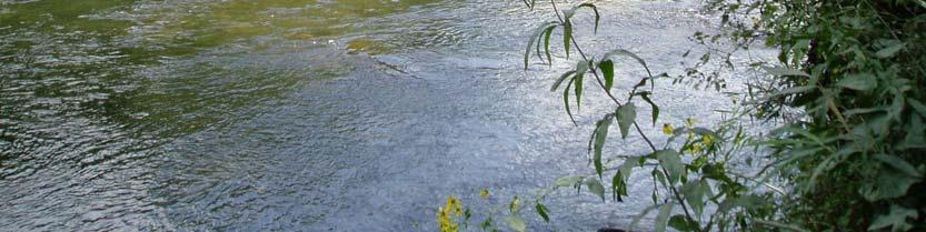
2 TABLE OF CONTENTS Introduction 1 What is a River Basin Restoration Priority? 1 Criteria for Selecting a Targeted Local Watershed (TLW) 2 Hiwassee River Basin Overview 3 Hiwassee River Basin Restoration Goals 4 River Basin and TLW Map 5 Targeted Local Watershed Summary Table 6 Discussion of TLWs in the Hiwassee River Basin 7 References 18 For More Information 18 Definitions 19 This document was updated by Andrea Leslie, western watershed planner. Cover Photo: Hiwassee River, Clay County
, Watershed Restoration Plan for the Hiwassee")
3 1 Introduction Tusquittee Creek This document, prepared by the North Carolina Ecosystem Enhancement Program (EEP), presents a description of Targeted Local Watersheds within the Hiwassee River Basin. This is an update of the original document developed in 2001 by the Wetlands Restoration Program (NCWRP, a precursor to EEP, which was formed in 2003), Watershed Restoration Plan for the Hiwassee Basin. The original plan selected five watersheds to be targeted for stream, wetland and riparian buffer restoration and protection and watershed planning efforts. This plan retains four of these original watersheds, plus presents an additional seven Targeted Local Watersheds (TLWs) for the Hiwassee River Basin. One 2001 TLW (Shooting Creek) was not retargeted in this document due to changes in the watershed and a reevaluation of local priorities. This document is a supplement to EEP s Watershed Restoration Plan for the Hiwassee River Basin (2001), and draws information from the detailed document, Hiwassee River Basinwide Water Quality Plan March 2007, which was written by the NC Division of Water Quality (NCDWQ). Therefore, this document does not provide detailed information found in those documents but provides a quick overview of EEP and the criteria EEP uses to select new Targeted Local Watersheds and then describes the newly selected Targeted Local Watersheds. In past documents, watersheds were delineated by the NCDWQ subbasin units and the smaller Targeted Local Watersheds were defined by USGS 14-digit hydrologic unit (HU). In this document, the watersheds are defined by the USGS 8-digit cataloging units and the Targeted Local Watersheds continue to be defined by the USGS 14-digit hydrologic unit. What is a River Basin Restoration Priority? EEP develops River Basin Restoration Priorities (RBRPs) to guide its mitigation activities within each of the major river basins. The RBRPs delineate specific watersheds that exhibit a need for restoration and protection of wetlands, streams and riparian buffers. These priority watersheds, or Targeted Local Watersheds (TLWs), are 14-digit hydrologic units which receive priority for EEP planning and project funds. The designation may also benefit stakeholders writing watershed improvement grants (e.g., Section 319 or Clean Water Management Trust Fund) by giving added weight to their proposals. North Carolina General Statute charges EEP to pursue wetland and riparian restoration activities in the context of basin restoration plans, one for each of the 17 major river basins in the State,
4 2 with the goal of protecting and enhancing water quality, fisheries, wildlife habitat, recreational opportunities and preventing floods. Criteria for Selecting Targeted Local Watersheds EEP evaluates a variety of GIS data and resource and planning documents on water quality and habitat conditions in each river basin to select TLWs. Public comment and the professional judgment of local resource agency staff also play a critical role in targeting local watersheds. TLWs are chosen based on an evaluation of three factors problems, assets, and opportunities. Problems reflect the need for restoration, assets reflect the ability for a watershed to recover from degradation and the need for land conservation, and opportunity indicates the potential for local partnerships in restoration and conservation work. TLWs that were chosen for the last Watershed Restoration Plan or River Basin Restoration Priorities document are reevaluated. If new information reveals that a watershed is not a good TLW candidate, then it will be removed from the TLW list. An explanation of the reasons for its removal from the list is provided in the last section of this document, which provides descriptions of each TLW chosen and delisted. Problems: EEP evaluates DWQ use support ratings, the presence of impaired /303(d)-listed streams, and DWQ Basinwide Assessment reports to identify streams with known problems. EEP also assesses the potential for degradation by evaluating land cover data, riparian buffer condition, and road density. Assets: In order to gauge the natural resource value of each watershed, EEP considers the amount of forested land, land in public or private conservation, riparian buffer condition, high and outstanding quality resource waters, and natural heritage elements. Opportunity: EEP reviews restoration and protection projects that are already on the ground, such as Clean Water Management Trust Fund projects, US Clean Water Act Section 319 projects, and land conservation projects. EEP also considers the potential for partnership opportunities by consulting with local, state, and federal resource agencies and conservation organizations, identifying their priority areas. Local Resource Professional Comments/Recommendations: The comments and recommendations of local resource agency professionals, including staff with Soil & Water Conservation districts, the Natural Resources Conservation Service (NRCS), county planning staff, NCDENR regional staff (e.g., Wildlife Resources Commission), and local/regional land trusts and watershed organizations are considered heavily in the selection of Targeted Local Watersheds. For the Hiwassee basin, input from the Hiwassee River Watershed Coalition was especially

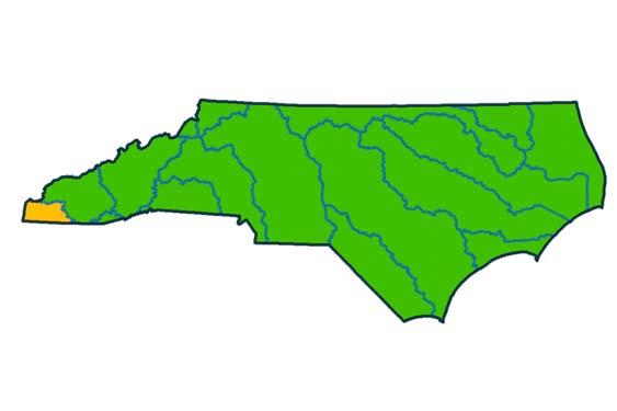
5 3 helpful. Local resource professionals often have specific and up-to-date information regarding the condition of local streams and wetlands. Furthermore, local resource professionals may be involved in local water resource protection initiatives that provide good partnership opportunities for EEP restoration and preservation projects and Local Watershed Planning initiatives. Hiwassee River Basin Overview Clay County horse farm The North Carolina portion of the Hiwassee River basin is 644 mi 2 and is located in the southwestern corner of North Carolina s Blue Ridge Province of the Appalachian Mountains. The headwaters of the Hiwassee River originate in North Carolina and north Georgia. It flows west into Tennessee and eventually merges with the Tennessee River. The Tennessee Valley Authority (TVA) dams the Hiwassee River for production of hydroelectric power, forming Lake Chatuge, Appalachia Lake, and Hiwassee Lake in North Carolina. The Hiwassee River basin is largely rural, with much of its population located in and around Hayesville, Murphy, and Andrews. It comprises most of Cherokee and Clay Counties, which have a combined population of 33,000 people, according to the 2000 census. Only about 2% of the area is considered urban. Agricultural land is important in the basin, with nearly 20% of the area in cultivated crop, pasture, and managed herbaceous vegetation. However, most of the land in the basin is forested, with about half of the forested land located in the Nantahala National Forest, which comprises 32% of the land area in the basin. The Hiwassee River and several of its tributaries (Valley River, Brasstown Creek, Hanging Dog Creek, Tusquitee Creek, and Fires Creek) are priority conservation areas for the Wildlife Resource Commission. Brasstown Creek and the Valley River are the largest unimpounded streams in the basin and host most of their historically known fauna (NCWRC, 2005). The draft (d) list includes a Persimmon Creek and a section of the Valley River. The basin consists of two larger watershed areas, called 8-digit catalog units, and , and it contains twenty-two smaller watershed areas, or 14-digit hydrologic units. Catalog unit is by far the larger of the two areas and contains twenty 14-digit hydrologic units. Catalog unit is at the far southwestern corner of the basin and contains only two 14-digit hydrologic units. From 2005 to 2007, EEP developed a local watershed plan for the Peachtree-Martins Creek watershed, which consists of four 14-digit hydrologic units. This plan identified a number of management strategies to address current problems and future problems resulting from additional population growth. This process resulted in a set of priority restoration

6 4 and preservation projects. EEP is implementing two stream and wetland restoration projects in the Martins Creek watershed. The Hiwassee River Watershed Coalition is also working to implement recommendations of the plan. Hiwassee River Basin Restoration Goals Bank erosion on Town Creek Based on an assessment of existing watershed characteristics and resource information, EEP has developed restoration goals for the Hiwassee River Basin. The goals reflect EEP s focus on restoring wetland and stream functions such as maintaining and enhancing water quality, restoring hydrology, and improving fish and wildlife habitat. Implement wetland and stream restoration projects that reduce sources of sediment and nutrients by restoring riparian buffer vegetation, stabilizing banks, and restoring natural geomorphology, especially in headwater streams. Restore and protect habitat for priority fish, mussel, snail, and crayfish species in the basin [see Wildlife Resource Commission (2005) for a complete list]. Prioritize project implementation in the Peachtree-Martins Creek local watershed planning area. Cooperate with the Hiwassee River Watershed Coalition and resource agencies to help leverage federal and state grant funding for watershed restoration efforts. Work with landowners, local resource agencies, local land trusts and other nongovernmental groups to protect and restore watersheds through restoration and preservation.

7 5 Hiwassee River Basin and Targeted Local Watershed Map
8 6 Targeted Local Watershed Summary Table Land Cover: % Developed Area Stream Miles Land Cover: on Draft 2008 % Agriculture 303(d) List Major Streams 14-digit Hydrologic Unit Area (sq mi) # of NHEOs Notes Hiwassee R, Local Sweetwater Cr priority Brasstown Cr TLW HQW & ORW Stream Miles WSW Stream Miles % of Streams with Trout Classification % of Streams with Forested Buffer Land Cover: % Forest & Wetland % of Land in Conservation Unnamed tributaries to Hiwassee R Peachtree- Martins LWP Upper Valley R TLW Middle Valley R ~5 miles of the Valley R TLW Lower Valley R ~3 miles of the Valley R TLW Peachtree Cr Peachtree- Martins LWP Mission Cr Peachtree- Martins LWP Martins Cr Peachtree- Martins LWP Persimmon Cr ~6 miles of Persimmon Cr Local priority S. Shoal, N. Shoal, Camp Cr *2001 TLW=targeted local watershed in 2001 plan; LWP=local watershed plan Other table acronyms: WSW=DWQ Water Supply Watershed; HQW=DWQ High Quality Water; ORW=DWQ Outstanding Resource Water; NHEO=Natural Heritage Element Occurrence, as maintained by the NC Natural Heritage Program Local priority

9 7 Discussion of Targeted Local Watersheds in Hiwassee River Basin This section provides a description and map of each watershed chosen as a Targeted Local Watershed (TLW) in 2008 and one watershed named as a TLW in 2001 but not targeted in Targeted Local Watersheds Hiwassee River/Sweetwater Creek: This watershed includes Hayesville and surrounding development. A majority of the streams are classified as Water Supply Waters. Twenty percent of its area is in agricultural use, primarily cattle pasture. Although there are no 303(d) listed streams in the watershed, it contains a number of degraded streams, including Sweetwater Creek, which is severely impacted by cattle access. It has much need for channel and riparian buffer restoration, and it is a restoration priority of the Hiwassee River Watershed Coalition. Hiwassee River/Sweetwater Creek watershed

10 8 Brasstown Creek: The Brasstown Creek watershed was a 2001 TLW and has long been a conservation priority of the Wildlife Resource Commission due to its important aquatic community. It is a major source of sediment to the Hiwassee River, and the Hiwassee River Watershed Coalition has been working with Brasstown landowners to restore channels and riparian areas since As with the Hiwassee River/Sweetwater Creek watershed, none of its streams are classified as Trout waters; however 100% of its streams are classified as Water Supply Waters. Brasstown Creek watershed

11 9 Unnamed Tributaries to Hiwassee River: This watershed is only 2 mi 2 and includes very small tributaries to the Hiwassee River near Murphy. Nineteen percent of the land area is in agricultural use, and half of its waters are classified as Water Supply Waters. The US-64 bypass, which is currently in construction, cuts through this watershed. It is one of four 14-digit hydrologic units in the Peachtree-Martins Creek local watershed planning area. Unnamed Tributaries to Hiwasse River watershed

12 10 Valley River Watersheds: Upper ( ), Middle ( ), and Lower ( ) All three of these watersheds were TLWs identified in 2001, and the Valley River watershed is a conservation priority of the NC Wildlife Resources Commission. This watershed is also a priority of the Hiwassee River Watershed Coalition, which began its Valley River Watershed Restoration Project in 2003, restoring key sites along the Valley River and its tributaries. The Land Trust for the Little Tennessee is developing a river corridor protection plan for the Valley River with the Coalition. Over half of the Upper Valley River watershed is in national forest, 58% of its streams are classified as Trout waters, and 89% of its streams have forested buffers. The Lower Valley River watershed has the highest amount of developed area (15%) in the Hiwassee basin, with the Valley River passing through Murphy. All three of the watersheds have high numbers of Natural Heritage Element Occurences. The Middle and Lower Valley River watersheds include a section of the Valley River that is on the draft (d) list due to excess turbidity. Upper Valley River watershed


13 11 Middle Valley River watershed Lower Valley River watershed

14 12 Peachtree Creek: The Peachtree Creek watershed is one of four 14-digit hydrologic units in the Peachtree-Martins Creek local watershed planning area. The US-64 bypass, which is currently in construction, cuts through this watershed, and it is expected that increased commercial and residential development will occur in this area. McComb Branch, a tributary to the Hiwassee River, is the focus of a stormwater impact and planning study by the Hiwassee River Watershed Coalition. Approximately 80% of this watershed is forested, and there are good opportunities to preserve forested tracts that are highly desirable for development. Peachtree Creek watershed

15 13 Mission Creek: This watershed is only 4 mi 2 and includes Mission Creek and Calhoun Creek. It is one of four 14-digit hydrologic units in the Peachtree-Martins Creek local watershed planning area. Twentytwo percent of this watershed is in agriculture, including cattle pasture and a large vegetable farm in the Hiwassee River valley. Mission and Calhoun Creeks are degraded by both residential and agricultural stressors. All of the streams in this watershed are classified as Water Supply Waters. Mission Creek watershed

16 14 Martins Creek: The Martins Creek watershed is one of four 14-digit hydrologic units in the Peachtree-Martins Creek local watershed planning area. The US-64 bypass, which is currently in construction, cuts through the downstream section of this watershed. Much of the Martins Creek valley is in cattle pasture, and the stream is impacted by high nutrient and fecal coliform bacteria levels and channelization; only 68% of the streams in this watershed have an adequate forested buffer. There are two EEP mitigation projects in design in this watershed, including one that will restore tributary that is severely impacted by cattle access, and another that will restore wetlands and streams in a former pasture area along Martins Creek and will preserve a number of high quality headwater streams. Martins Creek watershed
 list due to a degraded fish community.")
17 15 Persimmon Creek: Persimmon Creek and its northern neighbor, Beaverdam Creek, drain to Hiwassee Lake. Six miles of Persimmon Creek are on the draft (d) list due to a degraded fish community. About half of the streams in this watershed are classified as Trout waters, and almost 40% of the land area is in Nantahala National Forest, much along Hiwassee Lake and in the headwaters of Beaverdam Creek. The southern section of this watershed that drains Persimmon Creek is a new priority area of the Hiwassee River Watershed Coalition, which hopes to build on stream restoration efforts begun in 2006 by the Cherokee County Soil and Water Conservation District. The Coalition intends to develop a watershed plan for the Persimmon Creek watershed. As this is a very large watershed (80 mi 2 ), EEP recommends that any restoration or preservation efforts focus on the southern Persimmon Creek portion of the watershed. Persimmon Creek watershed

18 16 South Shoal/North Shoal/Camp Creek: South and North Shoal Creeks and Camp Creek drain a 50 mi 2 watershed to Appalachia Lake on the far western edge of the basin. About 90% of the land area in the watershed is forested, and 28% of the land is in Nantahala National Forest. There are a number of high value wetlands on the Camp and South Shoal Creek side of the lake that are not protected at this time but are conservation priorities of the Land Trust for the Little Tennessee. In addition, the acquisition of the Wilderness Lake tract, located on the southern side of the lake, is being considered by state officials. EEP recommends that any restoration or preservation efforts focus on the southern (South Shoal and Camp Creek) portion of this watershed. South Shoal/North Shoal/Camp Creek watershed
19 Targeted Local Watersheds Not Targeted in 2008 Shooting Creek: The Shooting Creek watershed was a 2001 TLW, but it is no longer considered a TLW for EEP. In 2001, it was listed as a TLW due to input from local stakeholders who described severe issues with bank erosion. However, a majority of these erosion problems were addressed with Emergency Watershed Protection funds designated for the area after 2004 Hurricanes Frances and Ivan. The Hiwassee River Watershed Coalition will continue to work with the Clay County Soil and Water Conservation District to plant backyard buffers in residential areas.
20 18 References NC Division of Water Quality Basinwide Planning Program. March Hiwassee River Basinwide Water Quality Plan. NC Wetlands Restoration Program Watershed Restoration Plan for the Hiwassee River Basin. NC Wildlife Resources Commission Wildlife Action Plan. For More Information Andrea Leslie Western Watershed Planner, EEP
21 19 Definitions EEP The North Carolina Ecosystem Enhancement combines existing wetlands restoration initiatives (formerly the Wetlands Restoration Program or NCWRP) of the N.C. Department of Environment and Natural Resources with ongoing efforts by the N.C. Department of Transportation (NCDOT) to offset unavoidable environmental impacts from transportation-infrastructure improvements. NCWRP The North Carolina Wetlands Restoration Program was a wetland restoration program under NC DENR and a predecessor of the NCEEP. USGS United States Geological Survey 8-digit Catalog Unit (CU) The USGS developed a hydrologic coding system to delineate the country into uniquely identified watersheds that can be commonly referenced and mapped. North Carolina has 54 of these watersheds uniquely defined by an 8-digit number. EEP typically addresses watershed based planning and restoration in the context of the 17 river basins (each has a unique 6-digit number), 54 catalog units and 1, digit hydrologic units. 14 digit Hydrologic Unit (HU) In order to address watershed management issues at a smaller scale, the U.S. Natural Resources Conservation Service (NRCS) developed methodology to delineate and uniquely identify watersheds at a scale smaller than the 8-digit catalog unit. A hydrologic unit is a drainage area delineated to nest in a multilevel, hierarchical drainage system. Its boundaries are defined by hydrographic and topographic criteria that delineate an area of land upstream from a specific point on a river, stream or similar surface waters. North Carolina has 1, digit hydrologic units. TLW - Targeted Local Watershed, are 14-digit hydrologic units which receive priority for EEP planning and restoration project funds. RBRP - The River Basin Restoration Priorities are documents that delineate specific watersheds (Targeted Local Watersheds) within a River Basin that exhibit both the need and opportunity for wetland, stream and riparian buffer restoration. Watershed Restoration Plan Older versions of RBRP documents were called Watershed Restoration Plans. In essence, they are the same thing. NCDWQ North Carolina Division of Water Quality
22 20 GIS - A geographic information system integrates hardware, software, and data for capturing, managing, analyzing, and displaying all forms of geographically referenced information.
Watershed Restoration Plan for the Hiwassee River Basin
 Watershed Restoration Plan for the Hiwassee River Basin i EXECUTIVE SUMMARY This document, prepared by the North Carolina Wetlands Restoration Program (NCWRP), presents a description of Targeted Local
State of the Water. October 25, 2016 Union County Community Center
 State of the Water October 25, 2016 Union County Community Center What is a Watershed? Nashville Birmingham Atlanta Athens Etowah Cleveland Murphy Andrews Hayesville Copper Hill Blue Ridge Young Harris
Maryland Chapter Trout Unlimited Brook Trout Conservation Effort
 Maryland Chapter Trout Unlimited Brook Trout Conservation Effort Photo by Matt Kline Portfolio of Recent Work MDTU Brook Trout Conservation Coordinator: Scott C. Scarfone, ASLA sscarfone@oasisdesigngroup.com
1.Mill Creek Watershed Summary Description and Land Use
 1.Mill Creek Watershed Summary Description and Land Use Table xxx: Mill Creek Watershed Overview Watershed Size 31,435 acres/49.1 sq miles/ 127.1 sq km Elevation Range 5,594 feet [4,967-10,561] Stream
Chagrin River TMDL Appendices. Appendix F
 Appendix F The following are excerpts from the Eastern Brook Trout Joint Venture s Conservation Strategy (Working Draft v.6), Conserving the Eastern Brook Trout: Strategies for Action Found at: http://www.easternbrooktrout.org/constrategy.html
Eastern Brook Trout. Roadmap to
 Eastern Brook Trout Roadmap to CONSERVATION Our Brook Trout heritage he wild Brook Trout is an American symbol of persistence, adaptability, and the pristine wilderness that covered North America prior
UTAH RECLAMATION MITIGATION AND CONSERVATION COMMISSION [RC0ZCUPCA0, 155R0680R1, RR ]
![UTAH RECLAMATION MITIGATION AND CONSERVATION COMMISSION [RC0ZCUPCA0, 155R0680R1, RR ]](/thumbs/86/94483046.jpg "UTAH RECLAMATION MITIGATION AND CONSERVATION COMMISSION [RC0ZCUPCA0, 155R0680R1, RR ]") This document is scheduled to be published in the Federal Register on 07/07/2015 and available online at http://federalregister.gov/a/2015-16600, and on FDsys.gov DEPARTMENT OF THE INTERIOR UTAH RECLAMATION
This document is scheduled to be published in the Federal Register on 07/07/2015 and available online at http://federalregister.gov/a/2015-16600, and on FDsys.gov DEPARTMENT OF THE INTERIOR UTAH RECLAMATION
Black Sturgeon Regional Plan
 Black Sturgeon Regional Plan This is one of twenty Regional Plans that support implementation of the Lake Superior Biodiversity Conservation Strategy (Strategy). The Strategy, prepared and overseen by
Example Applications
 Example Applications The following example applications are intended to present how the tools developed for Trout Unlimited s Brook Trout Conservation Portfolio and Range-wide Assessment of Habitat Condition
A Comparison of Western Watershed Councils. Presentation Prepared by Jeff Salt, Great Salt Lakekeeper
 A Comparison of Western Watershed Councils Presentation Prepared by Jeff Salt, Great Salt Lakekeeper Presentation Overview Introduction Jordan River Watershed Council Lower Boise Watershed Council Clackamas
DECISION MEMO. Pursuant to 36 C.F.R (e), the following persons are exempted from this order:
, the following persons are exempted from this order:") DECISION MEMO Forest Supervisor s Orders for the Upper Tellico Off-Highway Vehicle System USDA Forest Service Southern Region Nantahala National Forest Tusquitee Ranger District Cherokee County, North
DECISION MEMO Forest Supervisor s Orders for the Upper Tellico Off-Highway Vehicle System USDA Forest Service Southern Region Nantahala National Forest Tusquitee Ranger District Cherokee County, North
Trout Unlimited Comments on the Scope of Environmental Impact Statement for the Constitution Pipeline Project, Docket No. PF12-9
 October 9, 2012 Kimberly D. Bose, Secretary Federal Energy Regulatory Commission 888 First Street, NE, Room 1A Washington, DC 20426 RE: Trout Unlimited Comments on the Scope of Environmental Impact Statement
Outline. 1. Overview 2. Population 3. Flooding 4. Land Use 5. References. Overview
 Outline 1. Overview 2. Population 3. Flooding 4. Land Use 5. References Overview The two main rivers in the Cannon River watershed are the Cannon and Straight Rivers. The Cannon River originates in Shields
Searsville Dam Removal
 Searsville Dam Removal A unique opportunity for all Presented by the Beyond Searsville Dam Coalition San Francisquito Creek flows into the San Francisco Bay near the Palo Alto Airport and Golf Course seen
1.Warm Springs Creek (Anaconda) Watershed Description and Land Use
 Watershed Description and Land Use") 1.Warm Springs (Anaconda) Watershed Description and Land Use Table xxx: Warm Springs Watershed Overview Watershed Size 92,288 acres/144.2 sq miles/373.6 sq km Elevation Range 5,781 feet [4,800-10,581]
1.Warm Springs (Anaconda) Watershed Description and Land Use Table xxx: Warm Springs Watershed Overview Watershed Size 92,288 acres/144.2 sq miles/373.6 sq km Elevation Range 5,781 feet [4,800-10,581]
Executive Summary. Map 1. The Santa Clara River watershed with topography.
 Santa Clara River Steelhead Trout: Assessment and Recovery Opportunities December 2005 Prepared By: Matt Stoecker and Elise Kelley, Ph.D. University of California, Santa Barbara Prepared For: The Santa
Conserving the Forests, Lakes and Streams of Northeast Michigan
 4241 Old US 27 South, Suite 2, Gaylord, Michigan 49735 (989) 448-2293 www.huronpines.org info@huronpines.org Prioritized Restoration Projects in the AuSable River Watershed Summer 2015 Update from Huron
Trout Buffer Variance
 Trout Buffer Variance Ashley L. Rodgers, PE Spring 2015 Why a Trout Buffer Capturing pollutants in runoff to keep the water clean. Capturing sediment to keep mud out of the water. Providing shade to keep
SECTION 41 Table of Contents
 SECTION 41 Table of Contents 41 San Poil Subbasin Inventory of Existing Programs Terrestrial...2 41.1 Current Management Directions...2 41.2 Existing and Imminent Protections...3 41.3 Inventory of Recent
Upper Iroquois River atershed Management Plan
 2013 Upper Iroquois River atershed Management Plan Daniel M Perkins Jasper County Soil and Water Conservation District 12/30/2013 Table of Contents 1.1 WATERSHED COMMUNITY INITIATIVE... 12 1.2 Project
1.1 Subbasin Overview
 Chapter 1 Watauga River Subbasin 04-02-01 Including the: Watauga River, Boone Fork, Laurel Fork, Cove Creek, Beaverdam Creek, Beech Creek, Elk River and Cranberry Creek 1.1 Subbasin Overview Subbasin 04-02-01
Klickitat County Shoreline Master Program Update. Open House March 15, 2017
 Klickitat County Shoreline Master Program Update Open House March 15, 2017 Agenda 6:00 6:10 Welcome 6:10 6:40 Presentation SMP Update Process Shoreline Analysis review 6:40 8:00 Open House Topics SMP Process
The Spey Catchment Initiative
 The Spey Catchment Initiative Introducing the Spey Catchment Initiative The Spey Catchment Initiative is a new project which aims to help deliver the objectives of the River Spey Catchment Management Plan
Trout Unlimited and the Kittatinny Ridge Coalition.
 Trout Unlimited and the Kittatinny Ridge Coalition www.tu.org Trout Unlimited TU works to protect, reconnect, restore and sustain North America s coldwater fisheries and their watersheds. We use science
Interim Guidance Fish Presence Absence
 Interim Guidance Fish Presence Absence Source: Forest Practices Act Guidance for Division 635 of the forest practices act dealing with stream classification when no fish surveys have been done (referenced
Brook Trout in Massachusetts: A Troubled History, A Hopeful Future
 Brook Trout in Massachusetts: A Troubled History, A Hopeful Future Brook trout are one of the most beautiful and beloved fish in the Eastern United States. In Massachusetts, anglers prize opportunities
Fish and Wildlife Compensation Program Trevor Oussoren, program manager, Columbia region. CRT Workshop, Fauquier, June 15, 2013
 Angus Glass Fish and Wildlife Compensation Program Trevor Oussoren, program manager, Columbia region. CRT Workshop, Fauquier, June 15, 2013 The Fish and Wildlife Compensation Program is a partnership of:
Table xxx: Listed and Suspected Impairments for Willow Creek 2010 Reach Impairment Pollutant Impaired Uses
 1. (Fairmont) Watershed Summary Description and Land Use Table xxx: (Fairmont) Watershed Overview Watershed Size 18,331 acres/28.7 sq miles/74.3 sq km Elevation Range 2,615 feet [4,980-7,595] Stream Miles
Minnesota Department of Natural Resources Division of Fish and Wildlife Section of Fisheries. Stream Survey Report. Three Mile Creek 2011
 Minnesota Department of Natural Resources Division of Fish and Wildlife Section of Fisheries Stream Survey Report Three Mile Creek 2011 By Joseph D. Stewig Montrose Area Fisheries Office TABLE OF CONTENTS
COMMUNITY WATERSHED PROJECT
 SABINE RED RIVER COMMUNITY WATERSHED PROJECT A Watershed Approach to Aquatic Resources Do you have a stake in the water, the wildlife, the use of the land? Help us do for fish what was done for ducks*.
Project Webpage:
 Project Webpage: http://nature.ly/marinesatlanticbightera Coastal Data and Full Metadata: http://easterndivision.s3.amazonaws.com/marine/sab MA/SABMACoastalEcosystems.zip Coastal Chapter: http://easterndivision.s3.amazonaws.com/marine/sab
Mid-Columbia Fisheries Enhancement Group Annual Report Fiscal Year 06: July 1, 2005 June 30, 2006
 Mid-Columbia Fisheries Enhancement Group Annual Report Fiscal Year 06: July 1, 2005 June 30, 2006 Mission Statement The mission of the Mid-Columbia Fisheries Enhancement Group is to restore self-sustaining
DALE HOLLOW LAKE TROOPER ISLAND IMPROVEMENT PROJECT Proposal for Reservoir Fisheries Habitat Partnership (RFHP)
") DALE HOLLOW LAKE TROOPER ISLAND IMPROVEMENT PROJECT Proposal for Reservoir Fisheries Habitat Partnership (RFHP) A. Applicant Information: US Army Corps of Engineers, Dale Hollow Lake POC: Gregg Nivens
DALE HOLLOW LAKE TROOPER ISLAND IMPROVEMENT PROJECT Proposal for Reservoir Fisheries Habitat Partnership (RFHP) A. Applicant Information: US Army Corps of Engineers, Dale Hollow Lake POC: Gregg Nivens
Restoring the Kootenai: A Tribal Approach to Restoration of a Large River in Idaho
 Restoring the Kootenai: A Tribal Approach to Restoration of a Large River in Idaho Susan Ireland, Kootenai Tribe of Idaho Future of our Salmon Conference Technical Session August 2016 Healthy Floodplains,
Water in the Deschutes Who needs it?
 Water in the Deschutes Who needs it? Rivers and streams over appropriation and flow alteration. Junior water right holders production agriculture. The Cities long-term supply for growing populations. Climate
Chapter 1: Introduction
 Chapter 1: Introduction 1.0 The Report Card 1.0.1 Background People are becoming more aware of environmental issues locally and globally and want to know what they can do to improve their local watersheds.
OVERVIEW OF MID-COLUMBIA FISHERIES ENHANCEMENT GROUP
 Mid-Columbia Fisheries Enhancement Group MISSION STATEMENT The Mid-Columbia Fisheries Enhancement Group is a non-profit organization dedicated to restoring selfsustaining salmon and steelhead populations
Minnesota Department of Natural Resources Division of Fish and Wildlife Section of Fisheries. Stream Survey Report. Cold Spring Creek.
 Minnesota F-29-R(P)-24 Area 315 Study 3 March 2015 Minnesota Department of Natural Resources Division of Fish and Wildlife Section of Fisheries Stream Survey Report Cold Spring Creek 2014 Mark Pelham Montrose
Funding Habitat Restoration Projects for Salmon Recovery in the Snake River Region SRFB Grant Round Version: 2/19/16
 2016 SRFB Grant Round Version: 2/19/16 Funding Habitat Restoration Projects for Salmon Recovery in the Snake River Region The Project Funding Process Presented by the Snake River Salmon Recovery Lead Entity
Proposed Reclassification of Muskrat Creek, North Platte River Basin in Goshen County, Wyoming
 Proposed Reclassification of Muskrat Creek, North Platte River Basin in Goshen County, Wyoming October 25, 2010 Waterbody: Muskrat Creek - Mainstem of Muskrat Creek from its headwaters downstream to its
Okanagan Sockeye Reintroduction
 Okanagan Sockeye Reintroduction Backgrounder Elders accounts, and other forms of Traditional Ecological Knowledge (TEK) tell us that many species of salmon once came into the Okanagan Valley and tell us
TRCP National Sportsmen s Survey Online/phone survey of 1,000 hunters and anglers throughout the United States
 #17144 TRCP National Sportsmen s Survey Online/phone survey of 1,000 hunters and anglers throughout the United States Methodology Public Opinion Strategies conducted a national survey of N =1,000 voters
The Blue Heron Slough Conservation Bank
 1 The Blue Heron Slough Conservation Bank CONSERVATION BANKING July 19-23, 2010 CASE STUDY SERIES The Blue Heron Slough Conservation Bank (Washington) I. OVERVIEW & BACKGROUND: Location: Snohomish River
P.O. Box 65 Hancock, Michigan USA fax
 This PDF file is a digital version of a chapter in the 2005 GWS Conference Proceedings. Please cite as follows: Harmon, David, ed. 2006. People, Places, and Parks: Proceedings of the 2005 George Wright
NEVADA DEPARTMENT OF WILDLIFE STATEWIDE FISHERIES MANAGEMENT FEDERAL AID JOB PROGRESS REPORT F STREAM FISHERIES MANAGEMENT WESTERN REGION
 NEVADA DEPARTMENT OF WILDLIFE STATEWIDE FISHERIES MANAGEMENT FEDERAL AID JOB PROGRESS REPORT F-20-50 2014 STREAM FISHERIES MANAGEMENT WESTERN REGION NEVADA DEPARTMENT OF WILDLIFE, FISHERIES DIVISION ANNUAL
Unassessed Waters Initiative ( )
") Unassessed Waters Initiative (2010-2015) Robert Weber Fisheries Biologist PA Fish and Boat Commission Division of Fisheries Management Aiden Simpson Fisheries Biologist Western Pennsylvania Conservancy
Unassessed Waters Initiative (2010-2015) Robert Weber Fisheries Biologist PA Fish and Boat Commission Division of Fisheries Management Aiden Simpson Fisheries Biologist Western Pennsylvania Conservancy
FISH PASSAGE IMPROVEMENT in California s Watersheds. Assessments & Recommendations by the Fish Passage Forum
 FISH PASSAGE IMPROVEMENT in California s Watersheds Assessments & Recommendations by the Fish Passage Forum FISH PASSAGE IMPROVEMENT in California s Watersheds The mission of the Fish Passage Forum is
Burns Paiute Tribe Fisheries Department. Evaluate The Life History Of Native Salmonids Within The Malheur Subbasin Project #
 Burns Paiute Tribe Fisheries Department Evaluate The Life History Of Native Salmonids Within The Malheur Subbasin Project # 199701900 Prior to 1990 Technical and/or scientific background Malheur population,
FISHERIES MANAGEMENT PLAN FOR DUFFINS CREEK AND CARRUTHERS CREEK JUNE, 2004
 FISHERIES MANAGEMENT PLAN FOR DUFFINS CREEK AND CARRUTHERS CREEK JUNE, 2004 Toronto and Region Conservation 2004 ISBN0-9732764-0-1 www.trca.on.ca 5 Shoreham Drive, Toronto, Ontario M3N 1S4 phone: 416-661-6600
Climate Change Adaptation and Stream Restoration. Jack Williams;
 Climate Change Adaptation and Stream Restoration Jack Williams; jwilliams@tu.org 1 Goals for this presentation Develop strategies for adapting streams to climate impacts by Thinking like a watershed Understanding
The Cove Run Brook Trout Restoration Project with the Northern Garrett High School AP Environmental Science Class,
 The Cove Run Brook Trout Restoration Project with the Northern Garrett High School AP Environmental Science Class, 2012 2014. Image or Graphic Presented By: Alan W. Klotz, Western Region District I, Inland
PRE- PROPOSAL FORM - Lewis River Aquatic Fund
 PRE- PROPOSAL FORM - Lewis River Aquatic Fund 1. Applicant organization. USDA Forest Service Gifford Pinchot National Forest 2. Organization purpose Resource management agency 3. Project manager (name,
Minnesota Department of Natural Resources Division of Fish and Wildlife Section of Fisheries. Stream Survey Report. Luxemburg Creek.
 Minnesota F-29-R(P)-24 Area 315 Study 3 March 2016 Minnesota Department of Natural Resources Division of Fish and Wildlife Section of Fisheries Stream Survey Report Luxemburg Creek 2015 Mark Pelham Sauk
Gamefish Assessment Report
 MINNESOTA DEPARTMENT OF NATURAL RESOURCES Gamefish Assessment Report Spring Gamefish Assessment on the Mississippi River from Little Falls to Brainerd, MN May 31 through June 4, 2013 River Miles 966 to
 Time of Change We Are Growing We Are An Attractive Place To Live We Are Age Diverse + Living Longer 50000 40000 30000 20000 10000 0 2010 Census Job Density Housing Sheds Transit Sheds The Project FUNDING
Three point plan to addressing land use and habitat loss impacts on Chesapeake Bay tidal fish and shellfish
 Three point plan to addressing land use and habitat loss impacts on Chesapeake Bay tidal fish and shellfish 1. Establish Principles for Protection of Chesapeake Bay Fish and Shellfish The Fisheries GIT
FINAL REPORT. Yonkers Creek Migration Barrier Removal Project Wonderstump Road Del Norte County. Submitted By:
 FINAL REPORT Yonkers Creek Migration Barrier Removal Project Wonderstump Road Del Norte County Submitted By: Del Norte County Community Development Department Yonkers Creek Migration Barrier Removal Project
Sub-watershed Summaries
 Project Description The Salmon Drift Creek Watershed Council (SDCWC) has focused their efforts in the Salmon River estuary for the past few years. The multifaceted partnership effort is nearing completion
Warner Lakes Redband Trout
 Warner Lakes Redband Trout Existing Populations Warner Valley is an endorheic basin that contains a complex series of interconnected lakes, marshes, sloughs, and potholes, all of which are remnants of
Importance of Un-named tributaries to Brook Trout populations. Dr. Jonathan M. Niles
 Importance of Un-named tributaries to Brook Trout populations. Dr. Jonathan M. Niles PA Streams All streams of PA have a designated use - huge resource - 7,357 named streams: 33,687 total miles - 54,552
NEVADA DEPARTMENT OF WILDLIFE STATEWIDE FISHERIES MANAGEMENT
 NEVADA DEPARTMENT OF WILDLIFE STATEWIDE FISHERIES MANAGEMENT FEDERAL AID JOB PROGRESS REPORTS F-20-52 2016 REDBAND TROUT EASTERN REGION NEVADA DEPARTMENT OF WILDLIFE, FISHERIES DIVISION ANNUAL JOB PROGRESS
U.S. Fish and Wildlife Service Stream Habitat Improvement Projects
 U.S. Fish and Wildlife Service Stream Habitat Improvement Projects Melanie Car ter and Corey Kanuckel U.S. Fish & Wildlife Service Partners for Fish & Wildlife (PFW) Stream Team: Drew Langston Hunter Kittrell
Muskegon River Management Plan
 Muskegon River Management Plan River Management Plan 04, February, 2003 Richard P. O Neal Introduction This Plan is a companion document to the Muskegon River Watershed Assessment (O Neal 1997). The river
MCCAW REACH RESTORATION
 Final Report MCCAW REACH FISH RESTORATION PHASE B Jack McCaw Inland Empire Action Coalition http://www.wwccd.net/ Phone: 509-956-3777 Hours: 8:00-4:30 Walla Walla County Conservation District Snake River
Robert Weber PA Fish and Boat Commission Fisheries Biologist Fish Management Division
 Robert Weber PA Fish and Boat Commission Fisheries Biologist Fish Management Division Pennsylvania s Flowing Water Resources - Surveyed Stream Sections - Unassessed Stream Sections Pennsylvania s Flowing
Pennsylvania s Unassessed Waters Initiative ( )
") Pennsylvania s Unassessed Waters Initiative (2010-2013) Robert Weber PA Fish and Boat Commission Division of Fisheries Management Fisheries Biologist Renae Hodorowicz Western PA Conservancy Watershed Conservation
Pennsylvania s Unassessed Waters Initiative (2010-2013) Robert Weber PA Fish and Boat Commission Division of Fisheries Management Fisheries Biologist Renae Hodorowicz Western PA Conservancy Watershed Conservation
Columbia Lake Dam Removal Project
 Columbia Lake Dam Removal Project The Columbia Lake dam located 1/4 mile upstream of the Paulins Kill River's confluence with the Delaware River in Knowlton Township, Warren County has been proposed for
Salmon Five Point Approach restoring salmon in England
 Salmon Five Point Approach restoring salmon in England Our Mission To restore the abundance, diversity and resilience of salmon stocks throughout England We will do this by:- a) Maximising the production
Analysis Data Sources
 Page Technical Appendix D 1 SMP Analysis Data Sources the set bathymetry levee riprap mine lakebath_arc FloodHazardD ata.mdb\flood HazardZoneCo mponents\fhcl evee FloodHazardD ata.mdb\flood HazardZoneCo
Klamath Lake Bull Trout
 Klamath Lake Bull Trout Existing Populations The Klamath Lake Bull Trout SMU is comprised of seven existing populations and four populations classified as extinct or functionally extinct (Table 189). Populations
April 26, Chairman Rockefeller and members of the Fish and Wildlife Committee. Briefing from Mid-Columbia Regional Fish Enhancement Group (RFEG)
") Joan M. Dukes Chair Oregon Bruce A. Measure Montana James A. Yost Idaho W. Bill Booth Idaho Rhonda Whiting Vice-Chair Montana Bill Bradbury Oregon Tom Karier Washington Phil Rockefeller Washington April
Joan M. Dukes Chair Oregon Bruce A. Measure Montana James A. Yost Idaho W. Bill Booth Idaho Rhonda Whiting Vice-Chair Montana Bill Bradbury Oregon Tom Karier Washington Phil Rockefeller Washington April
Outstanding Iowa Waters, Trout Streams & Value to Northeast Iowa
 Outstanding Iowa Waters, Trout Streams & Value to Northeast Iowa Mike Steuck NE District Fisheries Supervisor Karst, WQ & Livestock: Finding a Balance for a Sensitive Geography May 30, 2017 Healthy Rivers,
3. The qualification raised by the ISRP is addressed in #2 above and in the work area submittal and review by the ISRP as addressed in #1.
 Please find attached a response from The Confederated Tribes of the Warm Springs Reservation of Oregon (CTWSRO) for Project # 2008-301-00, Habitat Restoration Planning, Design and Implementation within
Susquehanna University and the PFBC Unassessed Waters Initiative in the Susquehanna Basin Jonathan M. Niles Mike Bilger
 and the PFBC Unassessed Waters Initiative in the Susquehanna Basin 2011-2015 Jonathan M. Niles Mike Bilger Pennsylvania Streams All streams of PA have a designated use - Huge resource - 8,011 named tributaries:
Rebirth of the Pigeon River: Song of the Morning Dam Removal Project
 Major funding for this project was provided by: Michigan Department of Natural Resources Aquatic Habitat Grant Program $293,000 Golden Lotus, Inc. $100,000 Great Lakes Fishery Trust $46,000 Pigeon River
U.S. Fish and Wildlife Service Native American Crosscut Funding
 U.S. Fish and Wildlife Service Native American Crosscut Funding Tribal / Interior Budget Council National Budget Meeting L Enfant Plaza Hotel Washington, DC November 8, 2013 U.S. Fish and Wildlife Service
Wild Virginia and Heartwood first raised this issue at the May 19, 2014 public meeting.
 June 13, 2014 Karen Stevens Pat Sheridan, District Ranger Warm Springs Ranger District 422 Forestry Road Hot Springs, VA 24445 karenlstevens@fs.fed.us psheridan@fs.fed.us re: Lower Cowpasture Restoration
Aquatic Biological Assessment. Lassen 15 Restoration Project. Modoc National Forest Warner Mountain Ranger District
 Aquatic Biological Assessment Lassen 15 Restoration Project Modoc National Forest Warner Mountain Ranger District Prepared By:_/s/ Marty Yamagiwa Date: December 10, 2015 Marty Yamagiwa, Natural Resources
Results from the 2012 Quail Action Plan Landowner Survey
 Results from the 2012 Quail Action Plan Landowner Survey By Andrew W Burnett New Jersey DEP Division of Fish & Wildlife Mail Code 501 03 PO Box 420 Trenton 08625 0420 Abstract: A survey was conducted in
SOUTH CAROLINA ELECTRIC & GAS COMPANY COLUMBIA, SOUTH CAROLINA
 SOUTH CAROLINA ELECTRIC & GAS COMPANY COLUMBIA, SOUTH CAROLINA SALUDA HYDROELECTRIC PROJECT FERC NO. 516 DOWNSTREAM TEMPERATURE STUDY DRAFT REPORT MAY 28 Prepared by: SOUTH CAROLINA ELECTRIC & GAS COMPANY
PROTECTING LAND & RESTORING RIVERS FOR SALMON & STEELHEAD
 PROTECTING LAND & RESTORING RIVERS FOR SALMON & STEELHEAD Whychus Creek at Camp Polk Meadow Preserve. Photo: Russ McMillan Top photo: Deschutes River Conservancy 1 Photo: Byron Dudley A Unique Collaboration
Quarterly Progress Meeting - May Brook Trout Outcome. Stephen Faulkner, USGS Brook Trout Action Team Lead
 Quarterly Progress Meeting - May 2017 Brook Trout Outcome Stephen Faulkner, USGS Brook Trout Action Team Lead Through the Chesapeake Bay Watershed Agreement, the Chesapeake Bay Program has committed to
Tips for Using & Printing Spreadsheets
 Key to Spreadsheets Spreadsheet # Type Description/Purpose a Development & Construction in Waterways b Debits Development & Construction in Other Aquatic Areas c Indirect Impacts to Waterways from Development
Assessing Ecosystem Impacts from Road Stream Crossings through Community Involvement
 Assessing Ecosystem Impacts from Road Stream Crossings through Community Involvement Background Why is the NH Fish and Game Department interested in culverts? Block fish migration Reduce opportunities
Sustaining the Raritan River Watershed
 Sustaining the Raritan River Watershed 8 th Annual Sustainable Raritan River Conference June 10, 2016 Rick Lathrop Department of Ecology, Evolution & Natural Resources Rutgers School of Environmental and
BLM Cottonwood Field Office ATTN: Draft RMP/EIS 1 Butte Drive Cottonwood, ID Submitted Via to:
 Kevin Colburn National Stewardship Director American Whitewater 1035 Van Buren St. Missoula, MT 59802 406-543-1802 Kevin@amwhitewater.org BLM Cottonwood Field Office ATTN: Draft RMP/EIS 1 Butte Drive Cottonwood,
Environmental Review and Permitting for Wild Trout
 Environmental Review and Permitting for Wild Trout Tom Shervinskie Wild Trout Summit Watershed Analysis Section August 26, 2017 Division of Environmental Services The mission of the Pennsylvania Fish and
NEVADA DEPARTMENT OF WILDLIFE STATEWIDE FISHERIES MANAGEMENT
 NEVADA DEPARTMENT OF WILDLIFE STATEWIDE FISHERIES MANAGEMENT FEDERAL AID JOB PROGRESS REPORT F-20-50 2014 LAHONTAN CUTTHROAT TROUT STUDY WESTERN REGION NEVADA DEPARTMENT OF WILDLIFE, FISHERIES DIVISION
Eastern Brook Trout Joint Venture Completed Project Report Form
 Eastern Brook Trout Joint Venture Completed Project Report Form Project Title: Assessing the Efficacy of Remediating Episodic Low ph (and High Aluminum) Concentrations in Headwater Brook Trout Streams
Salmon River Cooperative Noxious Weed Program (CNWP) Presented by the Salmon River Restoration Council
 Presented by the Salmon River Restoration Council") Salmon River Cooperative Noxious Weed Program (CNWP) Presented by the Salmon River Restoration Council Some of you may be thinking So where is Salmon River? Isn t it in Idaho, Washington, or Oregon? The
Salmon River Cooperative Noxious Weed Program (CNWP) Presented by the Salmon River Restoration Council Some of you may be thinking So where is Salmon River? Isn t it in Idaho, Washington, or Oregon? The
Identifying and Executing Stream Projects Kristin Thomas, Aquatic Ecologist MITU
 Identifying and Executing Stream Projects Kristin Thomas, Aquatic Ecologist MITU Introduction 1. Methods for Identifying Projects 2. Methods in Action 3. The Partnership Paradigm 2 River Stewards Program
Undeveloped Zoning Inventory February 2004
 Undeveloped Zoning Inventory February 2004 Prepared by Planning Department Undeveloped Zoning Inventory February 2004 Project Description: The Undeveloped Zoning Inventory (the Inventory) is a periodic
A BLUEPRINT FOR THE PENOBSCOT RIVER WATERSHED
 A BLUEPRINT FOR THE PENOBSCOT RIVER WATERSHED About this series 2 # for a healthy Penobscot watershed M aine rivers used to be full of fish swimming upstream from the ocean every year on their spawning
Minnesota Department of Natural Resources Lanesboro Area Fisheries Office FAQ sheet
 Minnesota Department of Natural Resources Lanesboro Area Fisheries Office FAQ sheet 1) Can you fish with minnows in designated trout streams? Possessing live minnows or using them for bait on designated
Council Agenda Report
 Agenda Item #10 Council Agenda Report SUBJECT: REVIEW, DISCUSS AND APPROVE LETTER TO THE CENTRAL VALLEY FLOOD PROTECTION BOARD REGARDING ISSUES WITH THE CENTRAL VALLEY FLOOD PROTECTION PLAN MEETING DATE:
REVISED BIOLOGICAL OPINION FOR THE WLFW- Southwestern Willow Flycatcher. Stu Tuttle, USDA Natural Resources Conservation Service
 REVISED BIOLOGICAL OPINION FOR THE WLFW- Southwestern Willow Flycatcher Stu Tuttle, USDA Natural Resources Conservation Service The Working Lands for Wildlife Initiative (WLFW) WLFW is a national partnership
Restoring the Iconicc Lower Cache River
 Restoring the Iconicc Lower Cache River A new chapter holds promise of revitalizing cherished waters and woods The story of conservation in the lower Cache River and surrounding Big Woods of eastern Arkansas
FINAL Caples Lake Fisheries Management Plan. Version 4.0
 FINAL Caples Lake Fisheries Management Plan Version 4.0 August 15, 2008 Purpose The Caples Lake Fisheries Management Plan (Plan) outlines the stocking plan to reestablish a sport fishery in Caples Lake
2004 ANNUAL REPORT BOARD OF DIRECTORS
 2004 ANNUAL REPORT Enhancing and protecting the Upper Deschutes River watershed through collaborative projects in watershed stewardship, habitat enhancement, and community awareness. Dear Friends and Supporters,
Army Compatible Use Buffers (ACUB) Program
 Program") Army Compatible Use Buffers (ACUB) Program Region IV DoD/EPA/States Environmental Conference Janmichael Graine 29 June 2005 Janmichael Graine / SFIM-AEC-TSR / 410-436-1579 / DSN 584-1579 / janmichael.graine@us.army.mil
Army Compatible Use Buffers (ACUB) Program Region IV DoD/EPA/States Environmental Conference Janmichael Graine 29 June 2005 Janmichael Graine / SFIM-AEC-TSR / 410-436-1579 / DSN 584-1579 / janmichael.graine@us.army.mil