Sustaining the Raritan River Watershed
|
|
|
- Randolph Hoover
- 5 years ago
- Views:
Transcription


1 Sustaining the Raritan River Watershed 8 th Annual Sustainable Raritan River Conference June 10, 2016 Rick Lathrop Department of Ecology, Evolution & Natural Resources


2 Rutgers School of Environmental and Biological Science and the Edward J. Bloustein School of Planning and Public Policy launched the Sustainable Raritan River Initiative in 2009 in a collaboration for science informing planning informing policy. In Fall 2015 Jeanne Herb: EJB co-leader Rick Lathrop: SEBS co-leader Sara Malone: Program Assoc.

3 SRRI Action Plan (2009) Five Key areas of the Action Plan: Hazardous Site and Sediment Cleanup Improvements to Water Quality, Stormwater, and Infrastructure Stewardship of the Raritan River Basin Upgrade Public Access and Recreation Balancing Redevelopment and Restoration
4 Raritan Basin Watershed Management Plan ( ): Actions for moving forward Protection and preservation of critical watershed lands and headwater streams Maintenance and restoration of ground water recharge Improved control of stormwater Management of water supply resources Restoration of streams and riparian areas Restoration and protection of ground & surface waters

 for the Raritan")
5 The first priority of the Raritan Project was to characterize and assess the watersheds within the Basin to determine the current status of the environment, and how that status compares to community goals and to adopted standards in New Jersey. The characterization and assessment process determined a baseline condition (as of 1995) for the Raritan Basin against which future degradation or improvement can be compared.

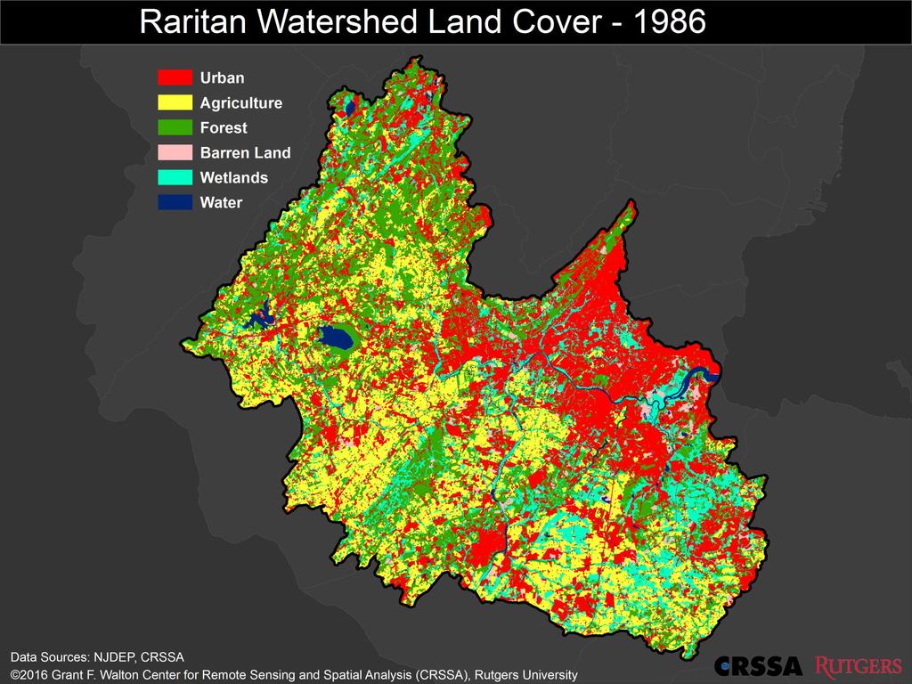
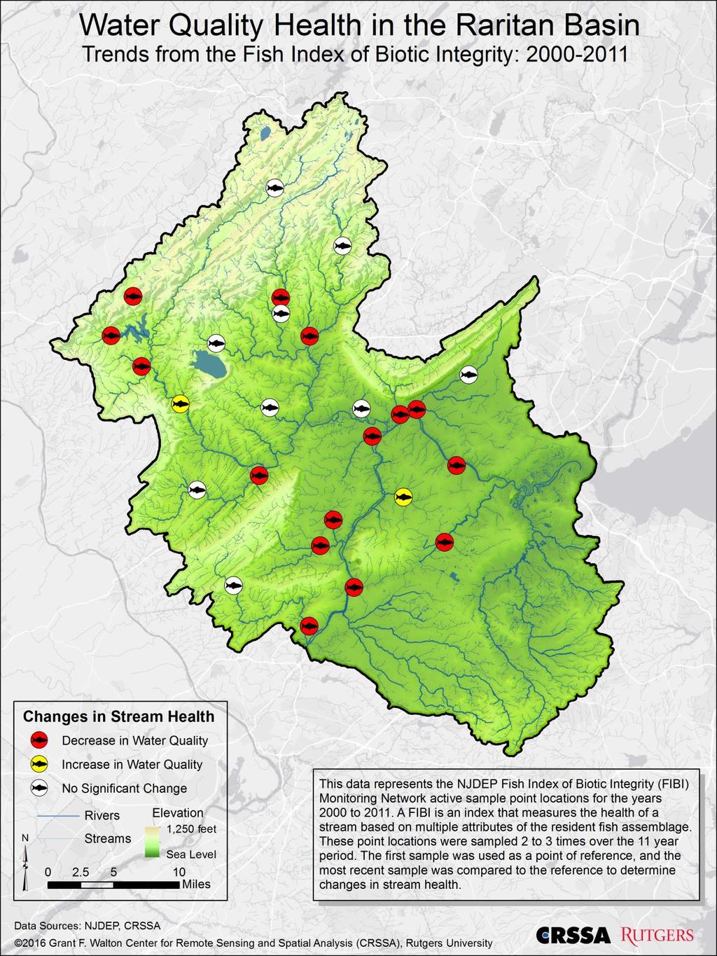
6 Raritan Basin Basin: Portrait of a Watershed (2002) Indicators: Land Use change Impervious Surface Wetlands Conversion Agricultural land & prime soil Groundwater recharge Contaminated Sites Bioassessment ratings Most of the indicators based on land use/land cover data as of 1995

7 So what is the state of the Raritan? An interim report. The population of the Raritan Basin is still growing. The Basin provides water to approximately million people in central New Jersey
8
9 Land Use change in the Raritan Land Cover in Acres Using a Modified 6 category Anderson Classification Scheme Agriculture 174, , , , ,102 Barren Land 12,930 9,780 9,836 7,859 6,949 Forest 187, , , , ,847 Water 13,073 13,516 14,643 15,596 15,806 Urban 224, , , , ,023 Wetlands 95,810 94,575 91,419 89,386 88,601 Impervious no data 77,197 85,342 89,482 91,082 Mean Annual Rate of Change in Acres Agriculture -2,813-3,184-1, Barren Land Forest , Water Urban 3,100 3,762 3,922 1,163 Wetlands Impervious no data 1,
10 4,500 3,500 3,762 3,922 3,100 Mean Annual Land Cover Changes for the Raritan Basin (acres) ,500 1,500 1, ,500-2, ,603-1, ,500-2,813-3,184 Urban Agriculture Barren Land Forest Water Agriculture


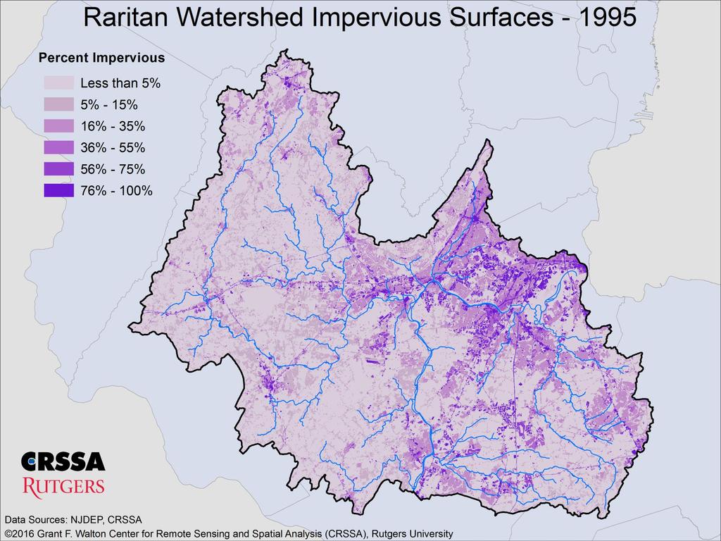
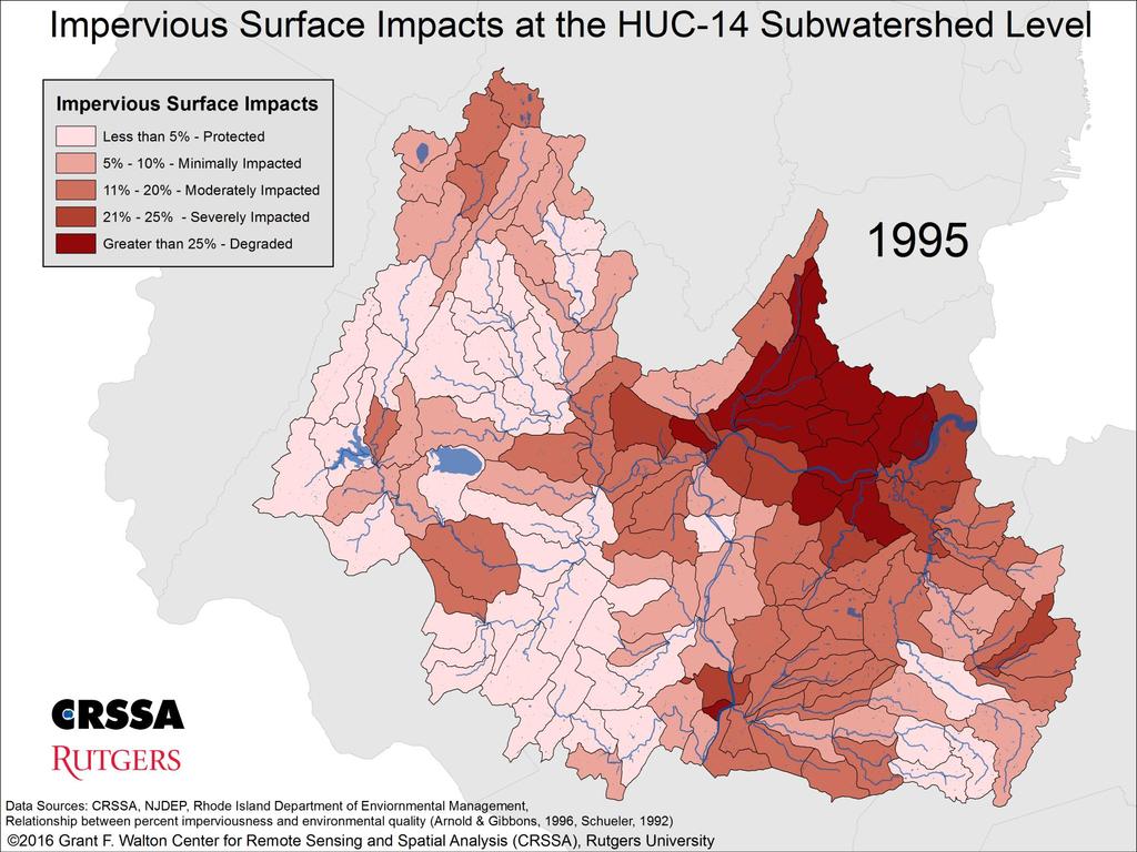
11 Impervious Surface and Stormwater runoff: Exporting problems downstream
12
13


14 Headwater streams and riparian zones critical linkages between upland watershed and downstream aquatic ecosystems
15


16 Proposed Rutgers Raritan River Station

17 Legacy of past contamination 980 as of ,723 KCS as of 2016

18 Many residents in the more rural areas of the Raritan River Basin get their drinking water from groundwater wells.


19 Flooding The Raritan River and Delaware and Raritan Canal spilled into Route 18 in New Brunswick following excessive rainfall from Tropical Storm Floyd. (Image: John Hasse/Rutgers University Department of Geography)


20 What are we doing about it? Peapack Brook Streambank Restoration Raritan Headwaters NJWSA- NJAES Photo courtesy of Central Jersey Stream Team)
21 Next Steps for the SRRI: Science informing planning informing policy Short term: Build on this conference s momentum in drawing together the disparate elements of Rutgers University to advance research, education and outreach efforts. Complete a State of the Raritan River report to assess progress on the Raritan Basin Watershed Management Plan and the SRRI Action Plan. Develop a Rutgers Raritan River real-time hydrological observatory to enhance the basin s real-time monitoring capacity and serve as a testbed for new sensor technology.
22 Next Steps for the SRRI: Science informing planning informing policy Longer term: Forge a stronger identity for the Raritan here on campus, Central Jersey and across the state. Assess the degree to which our stormwater management, watershed land preservation and riparian restoration efforts are counterbalancing the continued intensification of human land use to reverse the trend towards declining water quality. In this highly coupled human-environmental system, examine linkages between watershed health and human health.

23


24 One man s fight to save the canal Back in 1933, The Pennsylvania Railroad, which had a 999-year lease on the Delaware & Raritan Canal, announced the company s intention to abandon the canal. Morgan Seiffert, a New Brunswick attorney and Rutgers College graduate, in researching the original canal company charter found that that if the canal was ever abandoned, the charter would be annulled and the canal and associated land would revert to the state of New Jersey

25 One man s fight to save the canal In a subsequent legal case he coled, the Pennsylvania Railroad agreed not to contest the forfeiture and handed the canal over to the state in 1934 which subsequently turned it into a state park. Reflecting on the values of the D&R Canal 30 years later in 1965, People are beginning to realize the importance of our natural resources. They realize that our heavy industrialization and expanding population mean that added planning and money must be given to preserve the beauty of areas that we still have. --Morgan Seiffert
Maryland Chapter Trout Unlimited Brook Trout Conservation Effort
 Maryland Chapter Trout Unlimited Brook Trout Conservation Effort Photo by Matt Kline Portfolio of Recent Work MDTU Brook Trout Conservation Coordinator: Scott C. Scarfone, ASLA sscarfone@oasisdesigngroup.com
For Immediate Release
 c/o Environmental Analysis & Communications Group Edward J. Bloustein School of Planning & Public Policy Rutgers, The State University of New Jersey 33 Livingston Avenue New Brunswick, NJ 08901 raritan.rutgers.edu
Chagrin River TMDL Appendices. Appendix F
 Appendix F The following are excerpts from the Eastern Brook Trout Joint Venture s Conservation Strategy (Working Draft v.6), Conserving the Eastern Brook Trout: Strategies for Action Found at: http://www.easternbrooktrout.org/constrategy.html
Eastern Brook Trout. Roadmap to
 Eastern Brook Trout Roadmap to CONSERVATION Our Brook Trout heritage he wild Brook Trout is an American symbol of persistence, adaptability, and the pristine wilderness that covered North America prior
Minnesota Department of Natural Resources Division of Fish and Wildlife Section of Fisheries. Stream Survey Report. Luxemburg Creek.
 Minnesota F-29-R(P)-24 Area 315 Study 3 March 2016 Minnesota Department of Natural Resources Division of Fish and Wildlife Section of Fisheries Stream Survey Report Luxemburg Creek 2015 Mark Pelham Sauk
Trout Unlimited and the Kittatinny Ridge Coalition.
 Trout Unlimited and the Kittatinny Ridge Coalition www.tu.org Trout Unlimited TU works to protect, reconnect, restore and sustain North America s coldwater fisheries and their watersheds. We use science
A Comparison of Western Watershed Councils. Presentation Prepared by Jeff Salt, Great Salt Lakekeeper
 A Comparison of Western Watershed Councils Presentation Prepared by Jeff Salt, Great Salt Lakekeeper Presentation Overview Introduction Jordan River Watershed Council Lower Boise Watershed Council Clackamas
Climate Change Adaptation and Stream Restoration. Jack Williams;
 Climate Change Adaptation and Stream Restoration Jack Williams; jwilliams@tu.org 1 Goals for this presentation Develop strategies for adapting streams to climate impacts by Thinking like a watershed Understanding
Example Applications
 Example Applications The following example applications are intended to present how the tools developed for Trout Unlimited s Brook Trout Conservation Portfolio and Range-wide Assessment of Habitat Condition
Klickitat County Shoreline Master Program Update. Open House March 15, 2017
 Klickitat County Shoreline Master Program Update Open House March 15, 2017 Agenda 6:00 6:10 Welcome 6:10 6:40 Presentation SMP Update Process Shoreline Analysis review 6:40 8:00 Open House Topics SMP Process
Water in the Deschutes Who needs it?
 Water in the Deschutes Who needs it? Rivers and streams over appropriation and flow alteration. Junior water right holders production agriculture. The Cities long-term supply for growing populations. Climate
Searsville Dam Removal
 Searsville Dam Removal A unique opportunity for all Presented by the Beyond Searsville Dam Coalition San Francisquito Creek flows into the San Francisco Bay near the Palo Alto Airport and Golf Course seen
Removal of natural obstructions to improve Atlantic Salmon and Brook Trout habitat in western NL. 26/02/2015 Version 2.0
 Removal of natural obstructions to improve Atlantic Salmon and Brook Trout habitat in western NL 26/02/2015 Version 2.0 1 Table of Contents List of Tables... 2 Introduction... 3 Methods... 4 Preliminary
Outline. 1. Overview 2. Population 3. Flooding 4. Land Use 5. References. Overview
 Outline 1. Overview 2. Population 3. Flooding 4. Land Use 5. References Overview The two main rivers in the Cannon River watershed are the Cannon and Straight Rivers. The Cannon River originates in Shields
The North American Waterfowl Management Plan: Incorporating the New Goal
 The North American Waterfowl Management Plan: Incorporating the New Goal Mark P. Vrtiska, Ph.D. Waterfowl Program Manager Nebraska Game and Parks Commission Young Andy Bishop 2012 NAWMP Goals 1. Abundant
 Time of Change We Are Growing We Are An Attractive Place To Live We Are Age Diverse + Living Longer 50000 40000 30000 20000 10000 0 2010 Census Job Density Housing Sheds Transit Sheds The Project FUNDING
OPPORTUNITIES & CONSTRAINTS
 OPPORTUNITIES & CONSTRAINTS Grand Rapids Restoration August 2012 We have inherited the past; we can create the future Unknown TABLE OF CONTENTS ES-1 ES-1...... BACKGROUND CONCEPTUAL PLAN ES-2... OPPORTUNITIES
Audubon Cooperative Sanctuary Program for Golf Courses. Place Alternating Slideshow Photo Here
 Audubon Cooperative Sanctuary Program for Golf Courses Place Alternating Slideshow Photo Here Audubon Cooperative Sanctuary Program for Golf Courses In 1991, Audubon International, with the support of
Legacy Funding 2011 Special Session
 - Special Session FY2012 FY2013 Total FY2012 FY2013 Total Senate FY2012 FY2013 Total Senate 1 Art 1 - Outdoor Heritage Fund 2 3 Prairies 4 WMA, SNA, & Prairie Bank Easement Acq. Phase III 3,931-3,931 4,690-4,690
Managing Chesapeake Bay s Land Use, Fish Habitat, and Fisheries: Studies. Jim Uphoff & Margaret McGinty, Fisheries Service
 Managing Chesapeake Bay s Land Use, Fish Habitat, and Fisheries: Positive Image and or Negative Graphic Case Studies Jim Uphoff & Margaret McGinty, Fisheries Service Maryland Fisheries Service has been
Rutgers s future is the Raritan River 8 th Annual Sustainable Raritan River Conference June 10, 2016
 Rutgers s future is the Raritan River 8 th Annual Sustainable Raritan River Conference June 10, 2016 Oscar Schofield Marine and Coastal Sciences Center of Ocean Observing Leadership Right now, most Rutgers
Regional Planning & Tracking our Progress: Lessons from the Highlands
 Regional Planning & Tracking our Progress: Lessons from the Highlands New Jersey Highlands Water Protection and Planning Council Christine Danis, PP, AICP Director of Planning and Science 5 th Annual Sustainable
Brook Trout in Massachusetts: A Troubled History, A Hopeful Future
 Brook Trout in Massachusetts: A Troubled History, A Hopeful Future Brook trout are one of the most beautiful and beloved fish in the Eastern United States. In Massachusetts, anglers prize opportunities
Table xxx: Listed and Suspected Impairments for Willow Creek 2010 Reach Impairment Pollutant Impaired Uses
 1. (Fairmont) Watershed Summary Description and Land Use Table xxx: (Fairmont) Watershed Overview Watershed Size 18,331 acres/28.7 sq miles/74.3 sq km Elevation Range 2,615 feet [4,980-7,595] Stream Miles
Trout Unlimited Comments on the Scope of Environmental Impact Statement for the Constitution Pipeline Project, Docket No. PF12-9
 October 9, 2012 Kimberly D. Bose, Secretary Federal Energy Regulatory Commission 888 First Street, NE, Room 1A Washington, DC 20426 RE: Trout Unlimited Comments on the Scope of Environmental Impact Statement
1.Mill Creek Watershed Summary Description and Land Use
 1.Mill Creek Watershed Summary Description and Land Use Table xxx: Mill Creek Watershed Overview Watershed Size 31,435 acres/49.1 sq miles/ 127.1 sq km Elevation Range 5,594 feet [4,967-10,561] Stream
Preserving Biological Diversity for Future Generations
 The U.S. Fish and Wildlife Service Preserving Biological Diversity for Future Generations Flavia Rutkosky US Fish and Wildlife Service Delaware Bay Estuary Bay Project Office Smyrna, Delaware BIOLOGICAL
Eastern Brook Trout Joint Venture Completed Project Report Form
 Eastern Brook Trout Joint Venture Completed Project Report Form Project Title: Assessing the Efficacy of Remediating Episodic Low ph (and High Aluminum) Concentrations in Headwater Brook Trout Streams
MINUTES RARITAN & MILLSTONE RIVERS FLOOD CONTROL COMMISSION FEBRUARY 26, 2014
 MINUTES RARITAN & MILLSTONE RIVERS FLOOD CONTROL COMMISSION FEBRUARY 26, 2014 Chairman Jurewicz called the meeting to order at 7:07 p.m. Secretary McCarthy read the following Open Public Meetings Act Statement:
CHAPTER 7.0 IMPLEMENTATION
 CHAPTER 7.0 IMPLEMENTATION Achieving the vision of the Better Streets Plan will rely on the ability to effectively fund, build and maintain improvements, and to sustain improvements over time. CHAPTER
What is a River Basin Restoration Priority? 1. Criteria for Selecting a Targeted Local Watershed (TLW) 2. Hiwassee River Basin Overview 3
 2. Hiwassee River Basin Overview 3") Hiwassee River Basin Restoration Priorities 2008 TABLE OF CONTENTS Introduction 1 What is a River Basin Restoration Priority? 1 Criteria for Selecting a Targeted Local Watershed (TLW) 2 Hiwassee River
Hiwassee River Basin Restoration Priorities 2008 TABLE OF CONTENTS Introduction 1 What is a River Basin Restoration Priority? 1 Criteria for Selecting a Targeted Local Watershed (TLW) 2 Hiwassee River
Sea Level Rise in South Florida: Causes, Consequences and Opportunities
 Sea Level Rise in South Florida: Causes, Consequences and Opportunities Dr. Todd A. Crowl Director, Institute of Water & the Environment Director, Southeast Environmental Research Center Co-Founder, Sea
COLUMBIA LAKE DAM REMOVAL PROJECT
 COLUMBIA LAKE DAM REMOVAL PROJECT Major Goals of the Columbia Lake Dam Removal: Reconnect 10 miles of the Paulins Kill River to the Delaware River, restoring natural flow regime and sediment transport.
Advancing Fish Passage in the Menomonee River Watershed
 University of Massachusetts - Amherst ScholarWorks@UMass Amherst International Conference on Engineering and Ecohydrology for Fish Passage International Conference on Engineering and Ecohydrology for Fish
Eastern Brook Trout: Status and Threats
 david anderson Eastern Brook Trout: Status and Threats Background: Brook trout (Salvelinus fontinalis) are the only trout native to much of the eastern United States. They have inhabited the East s coldwater
Living Streets Policy
 Living Streets Policy Introduction Living streets balance the needs of motorists, bicyclists, pedestrians and transit riders in ways that promote safety and convenience, enhance community identity, create
Upper Iroquois River atershed Management Plan
 2013 Upper Iroquois River atershed Management Plan Daniel M Perkins Jasper County Soil and Water Conservation District 12/30/2013 Table of Contents 1.1 WATERSHED COMMUNITY INITIATIVE... 12 1.2 Project
By Lisa Barno, Chief, Bureau of Freshwater Fisheries and Pat Hamilton, Principal Fisheries Biologist
 Eastern Brook Trout Species in Peril By Lisa Barno, Chief, Bureau of Freshwater Fisheries and Pat Hamilton, Principal Fisheries Biologist New Jersey Fish & Wildlife Digest Buy your license or permit online
2. BACKGROUND. The West Branch Susquehanna River watershed
 2. BACKGROUND 2.1 The Susquehanna River watershed While the WBSR watershed includes several developed areas, forests cover about 83% of the land, and agricultural land makes up about 10%. Most abandoned
TRCP National Sportsmen s Survey Online/phone survey of 1,000 hunters and anglers throughout the United States
 #17144 TRCP National Sportsmen s Survey Online/phone survey of 1,000 hunters and anglers throughout the United States Methodology Public Opinion Strategies conducted a national survey of N =1,000 voters
The Cove Run Brook Trout Restoration Project with the Northern Garrett High School AP Environmental Science Class,
 The Cove Run Brook Trout Restoration Project with the Northern Garrett High School AP Environmental Science Class, 2012 2014. Image or Graphic Presented By: Alan W. Klotz, Western Region District I, Inland
Columbia Lake Dam Removal Project
 Columbia Lake Dam Removal Project Major Goals of the Columbia Lake Dam Removal: Reconnect 10 miles of the Paulins Kill River to the Delaware River, restoring natural flow regime and sediment transport.
Kissimmee River Channelization
 Environmental Restoration ti Update Phil Flood, South Florida Water Management District Presentation Overview Kissimmee River Restoration Everglades Stormwater Treatment Areas Comprehensive Everglades
State of the Water. October 25, 2016 Union County Community Center
 State of the Water October 25, 2016 Union County Community Center What is a Watershed? Nashville Birmingham Atlanta Athens Etowah Cleveland Murphy Andrews Hayesville Copper Hill Blue Ridge Young Harris
Three point plan to addressing land use and habitat loss impacts on Chesapeake Bay tidal fish and shellfish
 Three point plan to addressing land use and habitat loss impacts on Chesapeake Bay tidal fish and shellfish 1. Establish Principles for Protection of Chesapeake Bay Fish and Shellfish The Fisheries GIT
Restoring the Kootenai: A Tribal Approach to Restoration of a Large River in Idaho
 Restoring the Kootenai: A Tribal Approach to Restoration of a Large River in Idaho Susan Ireland, Kootenai Tribe of Idaho Future of our Salmon Conference Technical Session August 2016 Healthy Floodplains,
FISHERIES MANAGEMENT PLAN FOR DUFFINS CREEK AND CARRUTHERS CREEK JUNE, 2004
 FISHERIES MANAGEMENT PLAN FOR DUFFINS CREEK AND CARRUTHERS CREEK JUNE, 2004 Toronto and Region Conservation 2004 ISBN0-9732764-0-1 www.trca.on.ca 5 Shoreham Drive, Toronto, Ontario M3N 1S4 phone: 416-661-6600
FISHERIES BLUE MOUNTAINS ADAPTATION PARTNERSHIP
 FISHERIES A warming climate, by itself, substantially affects the hydrology of watersheds in the Blue Mountains. Among the key hydrologic changes projected under all scenarios for the 2040s and beyond
Drought Situations and Management Policy in Vietnam
 Regional Workshop for Asia-Pacific Capacity Development to Support National Drought Management Policy Drought Situations and Management Policy in Vietnam Nguyen Van Tinh, Dang Thanh Mai Hanoi, May 2014
middle deschutes progress in restoration
 middle deschutes progress in restoration Acknowledgements prepared by: Upper Deschutes Watershed Council Deschutes River Conservancy Oregon Department of Fish and Wildlife DESIGN & PRODUCTION FUNDED by:
Restoring the Iconicc Lower Cache River
 Restoring the Iconicc Lower Cache River A new chapter holds promise of revitalizing cherished waters and woods The story of conservation in the lower Cache River and surrounding Big Woods of eastern Arkansas
1.Warm Springs Creek (Anaconda) Watershed Description and Land Use
 Watershed Description and Land Use") 1.Warm Springs (Anaconda) Watershed Description and Land Use Table xxx: Warm Springs Watershed Overview Watershed Size 92,288 acres/144.2 sq miles/373.6 sq km Elevation Range 5,781 feet [4,800-10,581]
1.Warm Springs (Anaconda) Watershed Description and Land Use Table xxx: Warm Springs Watershed Overview Watershed Size 92,288 acres/144.2 sq miles/373.6 sq km Elevation Range 5,781 feet [4,800-10,581]
Columbia Lake Dam Removal Project
 Columbia Lake Dam Removal Project The Columbia Lake dam located 1/4 mile upstream of the Paulins Kill River's confluence with the Delaware River in Knowlton Township, Warren County has been proposed for
CATCHMENT HYDROLOGICAL RESPONSE TO CHANGING LAND SYSTEM IN KASHMIR HIMALAYA
 IGC, 2012 28 August, 2012 CATCHMENT HYDROLOGICAL RESPONSE TO CHANGING LAND SYSTEM IN KASHMIR HIMALAYA Prof. SHAKIL A ROMSHOO HEAD, DEPT OF EARTH SCIENCES KASHMIR UNIVERSITY PRESENTATION OVERVIEW KASHMIR
Iowa Department of Natural Resources Iowa Water Trails Grant Program
 Iowa Department of Natural Resources Iowa Water Trails Grant Program Submitted by the City of Story City in conjunction with the Skunk River Paddlers and the Story County Conservation Board Tuesday, January
Unassessed Waters Initiative ( )
") Unassessed Waters Initiative (2010-2015) Robert Weber Fisheries Biologist PA Fish and Boat Commission Division of Fisheries Management Aiden Simpson Fisheries Biologist Western Pennsylvania Conservancy
Unassessed Waters Initiative (2010-2015) Robert Weber Fisheries Biologist PA Fish and Boat Commission Division of Fisheries Management Aiden Simpson Fisheries Biologist Western Pennsylvania Conservancy
USING A LABYRINTH WEIR TO INCREASE HYDRAULIC CAPACITY. Dustin Mortensen, P.E. 1 Jake Eckersley, P.E. 1
 USING A LABYRINTH WEIR TO INCREASE HYDRAULIC CAPACITY Dustin Mortensen, P.E. 1 Jake Eckersley, P.E. 1 Plum Creek Floodwater Retarding Structure No. 6 is located in an area of Kyle, Texas, that is currently
Black Sturgeon Regional Plan
 Black Sturgeon Regional Plan This is one of twenty Regional Plans that support implementation of the Lake Superior Biodiversity Conservation Strategy (Strategy). The Strategy, prepared and overseen by
The Spey Catchment Initiative
 The Spey Catchment Initiative Introducing the Spey Catchment Initiative The Spey Catchment Initiative is a new project which aims to help deliver the objectives of the River Spey Catchment Management Plan
Faster, higher, stronger greener
 Faster, higher, stronger greener Sustainability at the 2012 London Olympics International events with a global audience are an ideal vehicle to promote sustainable development. In 1986 the President of
Deschutes River Conservancy Strategic Plan Executive Summary
 Deschutes River Conservancy Strategic Plan 2015-2025 Executive Summary 1 Mission The mission of the Deschutes River Conservancy (DRC) is to restore stream flow and improve water quality in the Deschutes
Corps Plays Vital Role in Protecting Pacific Reefs
 Public Affairs Office Contact: Joe Bonfiglio Honolulu Engineer District or Sarah H. Cox U.S. Army Corps of Engineers Telephone (808) 438-9862 Fort Shafter, Hawaii 96858-5440 FOR IMMEDIATE RELEASE May 17,
...A modern conservation solution. Mary Waclawski and Patrick Pham
 ...A modern conservation solution Mary Waclawski and Patrick Pham About Us - Class of 2019 at James Madison High School - Vienna, VA/Fairfax County - Members of Northern Virginia Trout Unlimited Purpose
ARKANSAS RIVER, LAKE FORK
 ARKANSAS RIVER, LAKE FORK 2012 The station just below County Road 11 (LF1) is routinely sampled as part of the protocol to monitor fish population changes relative to heavy metal cleanup in the Leadville
Developing a programme to make Taranaki predator-free
 Factsheet: 6 Developing a programme to make Taranaki predator-free The Taranaki Regional Council wants to initiate an innovative change in managing predators to benefit our native plants and wildlife,
ADOPT-A-STREAM WATERSHED APPROACH COMMUNITY-BASED STEWARDSHIP. Nova Scotia Salmon Association March 2005
 ADOPT-A-STREAM A WATERSHED APPROACH TO COMMUNITY-BASED STEWARDSHIP Nova Scotia Salmon Association March 2005 This manual is a revised and updated version of the 1994 Adopt-a-Stream manual that was prepared
2001 REVIEW OF THE ATLANTIC STATES MARINE FISHERIES COMMISSION FISHERY MANAGEMENT PLAN FOR WEAKFISH (Cynoscion regalis)
") 2001 REVIEW OF THE ATLANTIC STATES MARINE FISHERIES COMMISSION FISHERY MANAGEMENT PLAN FOR WEAKFISH (Cynoscion regalis) Plan Review Team Rick Cole, DE Louis Daniel, NC Charles Lesser, DE Rob O Reilly,
2001 REVIEW OF THE ATLANTIC STATES MARINE FISHERIES COMMISSION FISHERY MANAGEMENT PLAN FOR WEAKFISH (Cynoscion regalis) Plan Review Team Rick Cole, DE Louis Daniel, NC Charles Lesser, DE Rob O Reilly,
2009 Master Plan & Reexamination Report Verona, New Jersey
 2009 Master Plan & Reexamination Report Verona, New Jersey MASTER PLAN TOWNSHIP OF VERONA, NEW JERSEY PREPARED FOR THE PLANNING BOARD OF THE TOWNSHIP OF VERONA, NJ PREPARED BY KASLER ASSOCIATES, PA 34
U.S. Fish and Wildlife Service Stream Habitat Improvement Projects
 U.S. Fish and Wildlife Service Stream Habitat Improvement Projects Melanie Car ter and Corey Kanuckel U.S. Fish & Wildlife Service Partners for Fish & Wildlife (PFW) Stream Team: Drew Langston Hunter Kittrell
DALE HOLLOW LAKE TROOPER ISLAND IMPROVEMENT PROJECT Proposal for Reservoir Fisheries Habitat Partnership (RFHP)
") DALE HOLLOW LAKE TROOPER ISLAND IMPROVEMENT PROJECT Proposal for Reservoir Fisheries Habitat Partnership (RFHP) A. Applicant Information: US Army Corps of Engineers, Dale Hollow Lake POC: Gregg Nivens
DALE HOLLOW LAKE TROOPER ISLAND IMPROVEMENT PROJECT Proposal for Reservoir Fisheries Habitat Partnership (RFHP) A. Applicant Information: US Army Corps of Engineers, Dale Hollow Lake POC: Gregg Nivens
Delaware Basin Stream Management Program
 Delaware Basin Stream Management Program A partnership between NYCDEP and Delaware County Soil & Water Conservation District 2015 Update Delaware Basin - Topics 2015 Project Updates Restoration Projects
PROJECT TO INSTALL LARGE WOOD HABITAT STRUCTURES IN THE CARMEL RIVER USING CALIFORNIA DEPARTMENT OF FISH AND GAME GRANT FUNDS
 PROJECT TO INSTALL LARGE WOOD HABITAT STRUCTURES IN THE CARMEL RIVER USING CALIFORNIA DEPARTMENT OF FISH AND GAME GRANT FUNDS The Monterey Peninsula Water Management District (MPWMD), in cooperation with
Suitable Applications Check dams may be appropriate in the following situations: To promote sedimentation behind the dam.
 Categories EC Erosion Control SE Sediment Control TC Tracking Control WE Wind Erosion Control Non-Stormwater NS Management Control Waste Management and WM Materials Pollution Control Legend: Primary Category
OVERVIEW OF MID-COLUMBIA FISHERIES ENHANCEMENT GROUP
 Mid-Columbia Fisheries Enhancement Group MISSION STATEMENT The Mid-Columbia Fisheries Enhancement Group is a non-profit organization dedicated to restoring selfsustaining salmon and steelhead populations
Managing floodplain productivity: Slow it down, Spread it out, Grow em Up
 Managing floodplain productivity: Slow it down, Spread it out, Grow em Up Jacob Katz California Trout C. Jeffres Inland Sea J street Flood of 1862 A Shifting Mosaic of Wetland Habitat Types Dynamic Permanence
Volunteer Geographic Information: How Crowdsourced Data is Helping to Map the Spread of Brown Marmorated Stink Bug
 Volunteer Geographic Information: How Crowdsourced Data is Helping to Map the Spread of Brown Marmorated Stink Bug Noel Hahn, Alex Kaufman, George Hamilton Department of Entomology Rutgers University Background
DRAFT MEMORANDUM TO FILE
 FROM: SUBJECT: DRAFT MEMORANDUM TO FILE Unique Stream Segment Committee File [NTD02182] T:\Task 8 - Unique Designations and Regulatory Issues\Draft Committee Memo.doc Summary of Regional Water Planning
Tips for Using & Printing Spreadsheets
 Key to Spreadsheets Spreadsheet # Type Description/Purpose a Development & Construction in Waterways b Debits Development & Construction in Other Aquatic Areas c Indirect Impacts to Waterways from Development
City of Gainesville Transportation/Roadway Needs PROJECT SUMMARY
 A1 Roadway Resurfacing $23,846,000 TYPE: Preservation of existing system Roadway resurfacing A2 Signal Replacement $6,000,000 TYPE: Preservation of existing system Replace traffic signals. B1 W 6th St
A BLUEPRINT FOR THE PENOBSCOT RIVER WATERSHED
 A BLUEPRINT FOR THE PENOBSCOT RIVER WATERSHED About this series 2 # for a healthy Penobscot watershed M aine rivers used to be full of fish swimming upstream from the ocean every year on their spawning
Alberta Conservation Association 2016/17 Project Summary Report. Primary ACA staff on project: Stefanie Fenson, Jeff Forsyth and Jon Van Dijk
 Alberta Conservation Association 2016/17 Project Summary Report Project Name: Recreational Opportunity Enhancement Land Management Program Manager: Darren Dorge Project Leader: Stefanie Fenson Primary
One Truckee River Sparks City Council
 One Truckee River Sparks City Council What is the One Truckee River initiative? Working together for a sustainable, clean, thriving river community recognized in the hearts and minds of all for the treasure
Stewardship of the Lower Raritan River NEI Job Code: Project Code: S Final Report Grant dates July 25, 2011 March 31, 2013
 Stewardship of the Lower Raritan River NEI Job Code: 0294-002 Project Code: S-2011-042 Final Report Grant dates July 25, 2011 March 31, 2013 In 2011, the Association of New Jersey Environmental Commissions
Consortium Goals, Objectives, and Strategies FY18
 Consortium Goals, Objectives, and Strategies FY18 Introduction Rutgers Raritan River Consortium (R3C) is a collaborative effort at Rutgers University s New Brunswick-Piscataway campus that recognizes the
Integrated Pest Management Program Final Report
 Integrated Pest Management Program Final Report Shoreline Stewardship Program: Be a Lake Pan Pal Joan Bradshaw Specialized Regional Programs for Natural Resource Citrus, Hernando, Pasco and Sumter Counties
GRAND RAPIDS RESTORATION GRAND RAPIDS REVITALIZATION
 GRAND RAPIDS RESTORATION RETURNING THE RAPIDS TO THE GRAND WHY IS THIS PLACE CALLED GRAND RAPIDS? We have been asking for over 100- years, where are the rapids? WHY IS THIS PLACE CALLED GRAND RAPIDS? compare
San Luis Valley National Wildlife Refuge Complex, CO; Availability of Record of
 This document is scheduled to be published in the Federal Register on 12/11/2015 and available online at http://federalregister.gov/a/2015-31231, and on FDsys.gov Billing Code 4333 15 DEPARTMENT OF THE
PROTECTING LAND & RESTORING RIVERS FOR SALMON & STEELHEAD
 PROTECTING LAND & RESTORING RIVERS FOR SALMON & STEELHEAD Whychus Creek at Camp Polk Meadow Preserve. Photo: Russ McMillan Top photo: Deschutes River Conservancy 1 Photo: Byron Dudley A Unique Collaboration
UTAH RECLAMATION MITIGATION AND CONSERVATION COMMISSION [RC0ZCUPCA0, 155R0680R1, RR ]
![UTAH RECLAMATION MITIGATION AND CONSERVATION COMMISSION [RC0ZCUPCA0, 155R0680R1, RR ]](/thumbs/86/94483046.jpg "UTAH RECLAMATION MITIGATION AND CONSERVATION COMMISSION [RC0ZCUPCA0, 155R0680R1, RR ]") This document is scheduled to be published in the Federal Register on 07/07/2015 and available online at http://federalregister.gov/a/2015-16600, and on FDsys.gov DEPARTMENT OF THE INTERIOR UTAH RECLAMATION
This document is scheduled to be published in the Federal Register on 07/07/2015 and available online at http://federalregister.gov/a/2015-16600, and on FDsys.gov DEPARTMENT OF THE INTERIOR UTAH RECLAMATION
Chapter 7. Transportation. Transportation Road Network Plan Transit Cyclists Pedestrians Multi-Use and Equestrian Trails
 Chapter 7 Transportation Transportation Road Network Plan Transit Cyclists Pedestrians Multi-Use and Equestrian Trails 7.1 TRANSPORTATION BACKGROUND The District of Maple Ridge faces a number of unique
Unassessed Waters Initiative ( ) HOW CAN YOU HELP??
 HOW CAN YOU HELP??") Unassessed Waters Initiative (2010-2012) HOW CAN YOU HELP?? Robert Weber PA Fish and Boat Commission Fisheries Biologist Renae Greiner Western PA Conservancy Watershed Conservation Program Fisheries Biologist
Unassessed Waters Initiative (2010-2012) HOW CAN YOU HELP?? Robert Weber PA Fish and Boat Commission Fisheries Biologist Renae Greiner Western PA Conservancy Watershed Conservation Program Fisheries Biologist
Figure : Inflow/Outflow areas in the chain of lakes, characterized by flow reversal
 Leon County Lakes Ecology Bradford Brooks Chain of Lakes Lake Hiawatha, 2003 McGlynn Labs Inc. 5.3.1: Bradford Brooks Chain of Lakes Location: Munson Sandhills Drainage Basin: Bradford-Brooks, 3000 acres
Holderness. The Three Watersheds within the Newfound Lake Drainage Dorchester. Groton Plymouth. Ashland. Hebron. Canaan. Bridgewater.
 Background Brook trout are the only native stream dwelling trout species in New Hampshire, having a historic range that extended from Georgia to eastern Canada. It is believed that wild brook trout were
What was the historic coaster fishery like?
 1 of 6 1/30/2012 12:25 PM Home About Topics Contact Us Fishing Calendar Fish ID Tips FAQs Hack Noyes Research Vessel Is it a unique strain long lost from Wisconsin's shoreline? Fisheries Reports Tributaries
CHAPTER 4 DESIRED OUTCOMES: VISION, GOALS, AND OBJECTIVES
 CHAPTER 4 DESIRED OUTCOMES: VISION, GOALS, AND OBJECTIVES Vision One of the first steps in developing this Plan was articulating a vision - a clear statement of what the Plan strives to achieve and what
Amendment to a Biological Assessment/Evaluation completed for the Coon Creek Land Disposal completed December Grand Valley Ranger District
 Amendment to a Biological Assessment/Evaluation completed for the Coon Creek Land Disposal completed December 2007 Grand Valley Ranger District Grand Mesa, Uncompahgre, Gunnison National Forests Prepared
Urban Planning and Land Use
 Urban Planning and Land Use 701 North 7 th Street, Room 423 Phone: (913) 573-5750 Kansas City, Kansas 66101 Fax: (913) 573-5796 Email: planninginfo@wycokck.org www.wycokck.org/planning To: From: City Planning
Goal 3: Foster an environment of partnerships and collaboration to connect our communities and regions to one another.
 Non-Motorized Transportation Plan (NMTP) Draft Vision, Goal and,, Tri-County Regional Planning Commission (TCRPC) Purpose The purpose of the Tri-County Regional Planning Commission (TCRPC) Non-Motorized
Northwest Michigan Stream Connectivity
 Northwest Michigan Stream Connectivity Restoring Aquatic Ecosystems in the Upper Great Lakes CONSERVATION RESOURCE ALLIANCE Beaver Island 5 3 Iron Ore Creek Maple River Cheboygan Black River Petoskey Charlevoix
APPENDIX C. Fluvial and Tidal Hydraulics Report
 APPENDIX C Fluvial and Tidal Hydraulics Report BUENA VISTA LAGOON ENHANCEMENT PROJECT FLUVIAL AND TIDAL HYDRAULICS ANALYSES Prepared for: SANDAG 401 B Street, Suite 800 San Diego, California 92101 Contact: