Undeveloped Zoning Inventory February 2004
|
|
|
- Ferdinand May
- 5 years ago
- Views:
Transcription
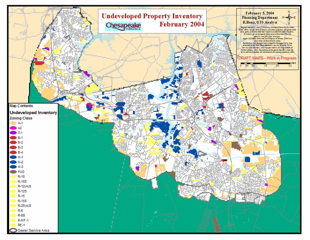
1 Undeveloped Zoning Inventory February 2004 Prepared by Planning Department
2 Undeveloped Zoning Inventory February 2004 Project Description: The Undeveloped Zoning Inventory (the Inventory) is a periodic tabulation of raw land by zoning classification within the existing service area for public utilities. The Inventory was originally limited to residentially zoned land; however, as a result of technological advancements associated with Geographic Information Systems (GIS), it has been expanded to include all zoning classifications. Also as a result of the improved technology, the Inventory now includes some indication of those areas that may be impacted by environmental constraints. This limitation has been estimated through the use of the information regarding the presence of vegetated hydric soils which provides some indication for the potential for wetlands. Project Parameters: In order for a site to be contained in the inventory, it must meet the following requirements: 1. Sites must be either undeveloped (unimproved) or a have an improvement value of less than $20,000 per acre. 2. Sites must be a minimum of 10 acres in size. 3. Sites must be within the City of Chesapeake s Public Utility Franchise Area. The Inventory does not include: Properties known to have an approved preliminary subdivision plat or site plan Future school or park sites Mitigation banks Borrow pits Holdings by the Nature Conservancy or other natural resource agencies State and Federal property Property zoned C-1 or C-2 (Conservation or Recreation) 2
3 Vegetated Hydric Soils The determination of whether or not wetlands exist on a property is subject to an official determination by the appropriate agencies and can only be definitively determined on a site by site basis. The general criteria for a wetland determination includes the presence of three criteria: 1) hydric soils, 2) hydrophytic vegetation, and 3) wetland hydrology. In an effort to estimate the lands that potentially meet these criteria, areas with hydric soils and areas which have natural vegetation have been mapped. Estimated Unit Yield Per Acre Calculations The calculation of estimated units is based upon typical density ranges provide by the Tidewater Builder s Association and from the Chesapeake Zoning Ordinance. The density ranges that have been used are as follows: Typical Zoning Class Unit Yield per Acre RE-1.33 R-40 1 R R-15 2 R R-10 3 R-8 4 R-6 4 R-TH 10 R-MF1 15 3
4 Results of the Inventory Inventory of Undeveloped Land by Zoning City Wide Totals February 4, 2004 Notes: 1. The results of this inventory conform to the project parameters outlined in the Project Parameters portion of this report. 2. Land designated to have vegetated hydric soils should not be considered to be undevelopable. This designation indicates that there is a likelihood that wetlands may exist on portions of the land given the presence of certain wetland indicators. Actual determinations must be made on a site by site basis. No accounting for the potential for wetland mitigation has been included in this estimate. Zoning District Total Acres Undeveloped Total Acres Undeveloped w/ Vegetated Hydric Soils % w/ Vegetated Hydric Soils A % AC % B % B % B % B % M % M % M % OI % PUD % R % R10S % R12AS % R12S % R % R15S % R25AS % R % R8S % RMF % RE % TOTALS % 4
5 5
6 Link to GIS Map in PDF Format Residential Zoning Summary Estimate of Unit Yield City Wide Totals February 4, 2004 Notes: 1. The results of this inventory conform to the project parameters outlined in the Project Parameters portion of this report. 2. Land designated to have vegetated hydric soils should not be considered to be undevelopable. This designation indicates that there is a likelihood that wetlands may exist on portions of the land given the presences of certain wetland indicators. Actual determinations must be made on a site by site basis. No accounting for the potential for wetland mitigation has been included in this estimate. Zoning District Total Acres Undevel Total Acres Undeveloped w/ Vegetated Hydric Soils % w/ Vegetated Hydric Soils Acres with No Potential Wetland Impact Typical Unit Yield per Acre Max Unit Yield (from Total Acres) Min Unit Yield (from No Impact Areas Only) R % R10S % R12AS % R12S % R % R15S % R25AS % R % R8S % RMF % RE % TOTALS % Residential Inventory Distribution by Zoning Classification 2% 5% 1% 2% 20% 0% 2% 68% R10 / R10s R12AS / R12s R15 / R15s R25AS R6 R8S RMF1 RE1
7 Distribution by Planning Area Undeveloped Property Inventory for Chesapeake, Virginia - February 5, 2004 Presented for each Planning Area in Acres by Zoning Classification and in Total Area in Acres Zoning Rivercrest South Norfolk Indian River Southern Chesapeake Western Branch Camelot Deep Creek Great Bridge Greenbrier Total A AC B B B B M M M OI PUD R R10S R12AS R12S R R15S R25AS R R8S RMF RE TOTALS
8 Zoning Rivercrest South Norfolk Indian River Distribution by Planning Area Undeveloped Residential Zoning -- Acres February 4, 2004 Southern Chesapeake Western Branch Camelot Deep Creek Great Bridge Greenbrier Total R R10S R12AS R12S R R15S R25AS R R8S RMF RE TOTAL Undeveloped Residential Zoning Typical Unit Yield February 4, 2004 Zoning Density Factor Rivercrest South Norfolk Indian River Southern Chesapeake Western Branch Camelot Deep Creek Great Bridge Greenbrier Total R R10S R12AS R12S R R15S R25AS R R8S RMF RE TOTAL Distribution of Residential Inventory by Planning Area 6% 1% 2% 1% 15% 18% 15% 9% 33% Rivercrest South Norfolk Indian River Southern Chesapeake Western Branch Camelot Deep Creek Great Bridge Greenbrier
9 Historical Results The following table summarizes the total number of residentially zoned acres from past Inventories. Some caution should be exercised in the comparison of past Inventories do to changes in project methodology. The previous Inventories did not use GIS technology and were conducted on paper zoning maps at a scale of 1 inch equals 200 feet. Actual acreage figure were measured using a digital planimeter. Due to the increased margin for human error, it is likely that some properties that were eligible for the Inventory in the past were not included. Other factors that contribute to differences between the Inventories include changes in zoning, development activity, and fluctuations in the limits of the utility service area. Total Acres Zoned for Residential Inventory Date Development Sep-92 6,993 Jul-94 5,956.9 Mar-95 5,558 Sep-95 5,349 May-96 5,090 Mar-97 5,151 Oct-97 4,928 Aug-98 4,783 Dec-99 4,131 Residential Inventory Over Time Sep-92 Sep-94 Sep-96 Sep-98 Sep-00 Sep-02 Acres Time
TRAFFIC STUDY GUIDELINES Clarksville Street Department
 TRAFFIC STUDY GUIDELINES Clarksville Street Department 9/1/2009 Introduction Traffic studies are used to help the city determine potential impacts to the operation of the surrounding roadway network. Two
COMPARISON OF FIXED & VARIABLE RATES (25 YEARS) CHARTERED BANK ADMINISTERED INTEREST RATES - PRIME BUSINESS*
 CHARTERED BANK ADMINISTERED INTEREST RATES - PRIME BUSINESS*") COMPARISON OF FIXED & VARIABLE RATES (25 YEARS) Fixed Rates Variable Rates FIXED RATES OF THE PAST 25 YEARS AVERAGE RESIDENTIAL MORTGAGE LENDING RATE - 5 YEAR* (Per cent) Year Jan Feb Mar Apr May Jun Jul
COMPARISON OF FIXED & VARIABLE RATES (25 YEARS) Fixed Rates Variable Rates FIXED RATES OF THE PAST 25 YEARS AVERAGE RESIDENTIAL MORTGAGE LENDING RATE - 5 YEAR* (Per cent) Year Jan Feb Mar Apr May Jun Jul
CCoWS. Central Coast Watershed Studies. Summary of Precipitation and Streamflow for Potrero and San Clemente Creeks in 2010
 Central Coast Watershed Studies CCoWS Summary of Precipitation and Streamflow for Potrero and San Clemente Creeks in Water-Year 2010 Santa Lucia Preserve Monterey County, California Publication No. WI-2011-01
Oakmont Area Structure Plan
 Oakmont Area Structure Plan Bylaw 12/97 Consolidated by Bylaw 25/2013 (Approved August 26, 2013) CITY OF ST. ALBERT CONSOLIDATION OF BYLAW 12/97 Consolidated by Bylaw 25/2013 Being a bylaw to adopt the
Minimum Bid: $4, Legal Description: DESCHUTES RIVER RECREATION HOMESITES UNIT 6, PART II, Lot 12, Block 79.
 Sale ID: 2016-17 Serial: 126490 Taxlot: 211002B004500 54688 Silver Fox Dr. Bend, OR 97707 Zoning RR-10; LM; WA Acreage: 0.34 Comments: Vacant platted lot (legal lot of record). In area of high groundwater
Minimum Bid: $7, Legal Description: DESCHUTES RIVER RECREATION HOMESITES, INC. UNIT 5; Lot 38; Block 27
 Sale ID: 2015-08 Serial: 115866 Taxlot: 201012C006300 16849 Fontana Rd. Bend, OR 97707 Zoning RR-10, WA Acreage: 0.49 TDC Number: Comments: Vacant platted legal lot. No permit history. Area of high ground
September 2017 MLS Statistical Report. Residential Inventory
 September 217 MLS Statistical Report Residential Inventory 2 2 1 1 21 216 217 Summary Inventories: Residential inventory is down 1%, Lots / Land inventory is down 13% and commercial inventory was down
Progress Report on the Design and Planning of an Infrastructure Improvement Project for the Sunnyside TIF District (Phase II)
") Presentation to the CNRC Board of Directors Regular Meeting March 11, 2015 1 Agenda Preferred Alternate Refinement for University Avenue, 3rd Street, and Beverly Avenue Intersection Improvements validate
Presentation to the CNRC Board of Directors Regular Meeting March 11, 2015 1 Agenda Preferred Alternate Refinement for University Avenue, 3rd Street, and Beverly Avenue Intersection Improvements validate
County of Orange Resources and Development Management Department Harbors, Beaches and Parks. Strategic Plan. HBP Strategic Plan Workshop 1.
 County of Orange Resources and Development Management Department Harbors, Beaches and Parks Strategic Plan HBP Strategic Plan Workshop 1 v18 PRESENTATION OUTLINE Harbors, Beaches & Parks (HBP) History
Planning & Zoning Commission
 Preliminary Plat Westwood, Section 3 Planning & Zoning Commission Planning & Development Department March 21, 2016 Request Subdivide approximately 38.1 acres of previously unplatted property to create
Bluetongue Disease (BT)
") Bluetongue Disease (BT) Analysis of ADNS data since 01/2018 Reporting period: 2018-01-01 2018-12-09 Data query: 2018-12-10 AGES DSR Austrian Agency for Health and Food Safety www.ages.at Parameters Data
Bluetongue Disease (BT) Analysis of ADNS data since 01/2018 Reporting period: 2018-01-01 2018-12-09 Data query: 2018-12-10 AGES DSR Austrian Agency for Health and Food Safety www.ages.at Parameters Data
Wetland Training Institute: 2018 Calendar of Courses
 Wetland Training Institute: 2018 Calendar of Courses Nov 2017 December 2017 Jan 2018 1 2 3 4 5 6 7 8 9 10 11 12 13 14 15 16 17 18 Opening date for all 2018 esessions esession Wetland Delineation with Emphasis
GALLUP NEWS SERVICE GALLUP POLL SOCIAL SERIES: WORLD AFFAIRS
 GALLUP NEWS SERVICE GALLUP POLL SOCIAL SERIES: WORLD AFFAIRS -- FINAL TOPLINE -- Timberline: 937008 IS: 954 Princeton Job #: 17-02-002 Jeff Jones, Lydia Saad February 1-5, 2017 Results are based on telephone
Lower Coquitlam River Project Water Use Plan. Temperature Monitoring Lower Coquitlam River Project Year 2 Report
 Lower Coquitlam River Project Water Use Plan Temperature Monitoring Lower Coquitlam River Project Year 2 Report COQMON#6 Temperature Monitoring Study Lower Coquitlam River Study Period: Year 2-2007 Report
GALLUP NEWS SERVICE GALLUP POLL SOCIAL SERIES: WORLD AFFAIRS
 GALLUP NEWS SERVICE GALLUP POLL SOCIAL SERIES: WORLD AFFAIRS -- FINAL TOPLINE -- Timberline: 937008 JT: 165 Princeton Job #: 18-02-002 Jeff Jones, Lydia Saad February 1-10, 2018 Results are based on telephone
GALLUP NEWS SERVICE GALLUP POLL SOCIAL SERIES: WORK AND EDUCATION
 GALLUP NEWS SERVICE GALLUP POLL SOCIAL SERIES: WORK AND EDUCATION -- FINAL TOPLINE -- Timberline: 937008 IS: 786 Princeton Job #: 16-08-012 Jeff Jones, Lydia Saad August 3-7, 2016 Results are based on
DISCLAIMER FOR ALL CITY OF KISSIMMEE DEVELOPMENT REVIEW APPLICATIONS
 DISCLAIMER FOR ALL CITY OF KISSIMMEE DEVELOPMENT REVIEW APPLICATIONS Important note: The Development Review process associated with this request (as outlined in the attached application) is intended to
Technical Report Culvert A Hydraulic Analysis
 DATE: November 3, 2011 Technical Report Culvert A Hydraulic Analysis TO: FROM: RE: Jim Reiser, P.E. Project Manager Parsons Brinckerhoff, Inc. Kurt Killian, P.E., CFM Parsons Brinckerhoff, Inc. Design
TRAFFIC IMPACT STUDY CRITERIA
 Chapter 6 - TRAFFIC IMPACT STUDY CRITERIA 6.1 GENERAL PROVISIONS 6.1.1. Purpose: The purpose of this document is to outline a standard format for preparing a traffic impact study in the City of Steamboat
CUPSIM Water Supply Variability Study All information subject to change.
 . 1 IN A NUTSHELL The CUP Water Supply Variability Study is an opportunistic, proactive example of responsible water system management The CUP is very complex and approaching full demand The study capitalizes
BULL CREEK RANCH 1,129± acres Osceola County, FL
 enjoy WATERFRONT, RECREATION & beautiful old Florida scenery COME DISCOVER ENDLESS POSSIBILITIES ON BULL CREEK RANCH! Located in the heart of Osceola County s ranch country, Bull Creek Ranch offers all
MEMORANDUM. 1. Modification of Map H to combine the 1.8 acre St. Johns County Courthouse Annex site with lands owned by the Tour as part of the DRI.
 MEMORANDUM DATE: JULY 3, 2017 TO: FROM: RE: NORTHEAST FLORIDA REGIONAL COUNCIL EXECUTIVE COMMITTEE BRIAN TEEPLE, CHIEF EXECUTIVE OFFICER CABALLOS DEL MAR DEVELOPMENT OF REGIONAL IMPACT NOTICE OF PROPOSED
Utility Debt Securitization Authority 2013 T/TE Billed Revenues Tracking Report
 Utility Debt Securitization Authority 2013 T/TE Billed Revenues Tracking Report Billing Budgeted Billed Dollar Percent Month Revenues Revenues Variance Variance Jan 2018 11,943,180.68 12,697,662.47 754,481.79
How did you hear about this meeting?
 How did you hear about this meeting? Please stick a dot in each category that applies Radio or TV Postcard Email City Website Advertisement (Newspaper, internet) Other (Facebook, word of mouth, etc.) Future
DISCLAIMER FOR ALL CITY OF KISSIMMEE DEVELOPMENT REVIEW APPLICATIONS
 DISCLAIMER FOR ALL CITY OF KISSIMMEE DEVELOPMENT REVIEW APPLICATIONS Important note: The Development Review process associated with this request (as outlined in the attached application) is intended to
Wind Resource Assessment for CHEFORNAK, ALASKA
 813 W. Northern Lights Blvd. Anchorage, AK 99503 Phone: 907-269-3000 Fax: 907-269-3044 www.akenergyauthority.org Wind Resource Assessment for CHEFORNAK, ALASKA Date last modified: 3/15/2006 Compiled by:
 Time of Change We Are Growing We Are An Attractive Place To Live We Are Age Diverse + Living Longer 50000 40000 30000 20000 10000 0 2010 Census Job Density Housing Sheds Transit Sheds The Project FUNDING
MARKET AND CAPACITY UPDATE. Matthew Marsh September 2016
 MARKET AND CAPACITY UPDATE Matthew Marsh September 2016 1980 1981 1982 1983 1984 1985 1986 1987 1988 1989 1990 1991 1992 1993 1994 1995 1996 1997 1998 1999 2000 2001 2002 2003 2004 2005 2006 2007 2008
Winter Drawdown Issues of Concern
 Winter Drawdown Issues of Concern Wetland Connectivity Amphibians Fisheries Winter Drawdown Wetland Connectivity Wetland complex near Osprey Creek is not responsive to lake level Wetland at upper end of
Coquitlam/Buntzen Project Water Use Plan
 Coquitlam/Buntzen Project Water Use Plan Temperature Monitoring Lower Coquitlam River Project Year 3 Report Reference: COQMON#6 Study Period: March 2008 April 2009 Report Date: April 2009 Trow Associates
Youngs Creek Hydroelectric Project
 Youngs Creek Hydroelectric Project (FERC No. 10359) Resident Trout Monitoring Plan Annual Report 2014 Survey Prepared by: Everett, WA November 2014 Final This document has been prepared for the District.
Eastern Brook Trout Joint Venture Annual Report The Nature Conservancy 2013
 Eastern Brook Trout Joint Venture Annual Report The Nature Conservancy 2013 2013 Annual Performance Report Enhancing Connectivity in the Ash-Black Rock Sub-basin of the West Branch Narraguagus River. Project
NEVADA SLOT MACHINES: HISTORICAL HOLD PERCENTAGE VARIATIONS ANNUAL AND MONTHLY HOLD PERCENTAGES, CENTER FOR GAMING RESEARCH, NOVEMBER 2017
 NEVADA SLOT MACHINES: HISTORICAL HOLD PERCENTAGE VARIATIONS ANNUAL AND MONTHLY HOLD PERCENTAGES, 2004-2017 CENTER FOR GAMING RESEARCH, NOVEMBER 2017 Executive Summary Hold percentage the portion of money
Kodiak, Alaska Site 1 Wind Resource Report
 Kodiak, Alaska Site 1 Wind Resource Report Report written by: Douglas Vaught, P.E., V3 Energy LLC, Eagle River, AK Date of report: March 16, 2007 Photo by Doug Vaught, V3 Energy LLC Summary Information
INNCOM SYSTEM MONITORING MARRIOT HOTEL DOWNTOWN PHILADELPHIA, PA. Report 9. July 2, CH2M HILL Project No
 INNCOM SYSTEM MONITORING MARRIOT HOTEL DOWNTOWN PHILADELPHIA, PA Report 9 CH2M HILL Project No. 421631 1. PURPOSE The purpose of this report is to present observations of the Inncom system operation in
City of Hanover TRANSPORTATION STUDY
 City of Hanover TRANSPORTATION STUDY AUGUST 2006 Prepared by: WSB & Associates, Inc. 701 Xenia Avenue South, Suite 300 Minneapolis, MN 55416 (763) 541-4800 (763) 541-1700 (Fax) City of Hanover Transportation
Initial Study Report Whitewater Boating
 Initial Study Report Whitewater Boating Prospect No. 3 Hydroelectric Project FERC Project No. P-2337 PacifiCorp May 2015 South Fork of the Rogue River, 2007 Reproduced with permission from Peter Gandesbery,
Nexus/Proportionality Study Lakeview Estates Off-Site Walking Route
 Draft Hearing Report Nexus/Proportionality Study Lakeview Estates Off-Site Walking Route Prepared for: County of Merced Prepared by: Economic & Planning Systems, Inc. January 2011 EPS #20544 Table of Contents
DISCLAIMER FOR ALL CITY OF KISSIMMEE DEVELOPMENT REVIEW APPLICATIONS
 DISCLAIMER FOR ALL CITY OF KISSIMMEE DEVELOPMENT REVIEW APPLICATIONS Important note: The Development Review process associated with this request (as outlined in the attached application) is intended to
Chapter 5 FUNCTIONAL CLASSIFICATION
 Chapter 5 FUNCTIONAL CLASSIFICATION Functional classification is a system by which streets and roadways may be distinguished by types according to their function within the entire transportation network.
City of Santa Cruz Interim Tarplant Management
 City of Santa Cruz Interim Tarplant Management 1995-2011 In 2002 65 acres of Arana Gulch was designated as critical habitat for the Santa Cruz tarplant by the U.S. Fish and Wildlife Service (USFWS). The
Traffic Impact Analysis Walton Acres at Riverwood Athletic Club Clayton, NC
 Traffic Impact Analysis Walton Acres at Riverwood Athletic Club Clayton, NC 1. TABLE OF CONTENTS INTRODUCTION...1 1.1. Site Location and Study Area...1 1.2. Proposed Land Use and Site Access...2 1.3.
2009 Master Plan & Reexamination Report Verona, New Jersey
 2009 Master Plan & Reexamination Report Verona, New Jersey MASTER PLAN TOWNSHIP OF VERONA, NEW JERSEY PREPARED FOR THE PLANNING BOARD OF THE TOWNSHIP OF VERONA, NJ PREPARED BY KASLER ASSOCIATES, PA 34
San Antonio Creek Spreading Grounds Rehabilitation Project Ojai Valley, CA
 Ventura County Watershed Protection District San Antonio Creek Spreading Grounds Rehabilitation Project Ojai Valley, CA Presentation to Ventura River Watershed Council Project Funding Proposition 50 Integrated
DISCLAIMER FOR ALL CITY OF KISSIMMEE DEVELOPMENT REVIEW APPLICATIONS
 DISCLAIMER FOR ALL CITY OF KISSIMMEE DEVELOPMENT REVIEW APPLICATIONS Important note: The Development Review process associated with this request (as outlined in the attached application) is intended to
35.46 ACRES FOR SALE
 San Diego County Jurisdiction Active Agriculture Use 1 DU/Acre SALE PRICE: $1,200,000 LILAC RD V ISTA VALLEY COUNTRY CLUB OLD CASTLE RD COLE GRANDE RD SUBJECT PROPERTY VALLEY CENTER RD TURNER LAKE N Lee
A G E N D A OKLAHOMA COUNTY PLANNING COMMISSION. November 16, Approval of Minutes of the Previous Meeting: (October 19, 2006)
") A G E N D A OKLAHOMA COUNTY PLANNING COMMISSION ROOM 103 1:30 p.m. November 16, 2006 1. Notice of meeting posted November 9, 2006. 2. Call to Order. 3. Roll Call. 4. Approval of Minutes of the Previous
A G E N D A OKLAHOMA COUNTY PLANNING COMMISSION ROOM 103 1:30 p.m. November 16, 2006 1. Notice of meeting posted November 9, 2006. 2. Call to Order. 3. Roll Call. 4. Approval of Minutes of the Previous
2015 Data review. Capturing Ready Lane NEXUS vehicles
 2015 Data review Capturing Ready Lane NEXUS vehicles Problem: NEXUS users make up the majority of traffic using the Ready Lane, but they are currently considered either standard traffic or Ready Lane traffic.
Administration Report Fiscal Year 2011/2012
 Administration Report Fiscal Year 2011/2012 Poway Unified School District Community Facilities District No. 3 June 20, 2011 Prepared For: Poway Unified School District Planning Department 13626 Twin Peaks
Administration Report Fiscal Year 2010/2011
 Administration Report Fiscal Year 2010/2011 Poway Unified School District Community Facilities District No. 3 June 21, 2010 Prepared For: Poway Unified School District 13626 Twin Peaks Road Poway, CA 92064
Overview Open Space and Recreation
 Overview Open Space and Recreation Open Space Plan (2004) Environmental Priority Areas Town Character Priority Areas Recreational Facilities maintained by the Town RSU 21 Recreational Facilities in Kennebunk
Carbondale to Murphysboro Bike Route JACKSON COUNTY
 Carbondale to Murphysboro Bike Route JACKSON COUNTY March, 2017 PREPARED BY: Southern Illinois Metropolitan Organization Table of Contents Introduction... 1 A. Project Purpose and Study Area... 1 B. Previous
Weather and Climate Impacts on Water Supply
 Weather and Climate Impacts on Water Supply Nolan Doesken Colorado Climate Center Atmospheric Science Department Colorado State University http://ccc.atmos.colostate.edu Presented at the South Platte Forum,
September 9, Planning and Land Development Regulation Commission (PLDRC)
") Page 1 of 19 GROWTH AND RESOURCE MANAGEMENT DEPARTMENT PLANNING AND DEVELOPMENT SERVICES DIVISION CURRENT PLANNING ACTIVITY 123 W. Indiana Avenue, Room 202, DeLand, FL 32720 (386) 943-7059 PUBLIC HEARING:
Page 1 of 19 GROWTH AND RESOURCE MANAGEMENT DEPARTMENT PLANNING AND DEVELOPMENT SERVICES DIVISION CURRENT PLANNING ACTIVITY 123 W. Indiana Avenue, Room 202, DeLand, FL 32720 (386) 943-7059 PUBLIC HEARING:
Plan B Dam Breach Assessment
 Plan B Dam Breach Assessment Introduction In support of the Local Sponsor permit applications to the states of Minnesota and North Dakota, a dam breach analysis for the Plan B alignment of the Fargo-Moorhead
Chapter 2: Alternatives
 Chapter 2: Alternatives 2.1 Introduction This chapter describes the alternatives that were considered for meeting the purpose of the State Route (S.R.) 30 Project as described in Section 1.2.1, Purpose
Discussion on the Selection of the Recommended Fish Passage Design Discharge
 Discussion on the Selection of the Recommended Fish Passage Design Discharge Introduction The provision of fish passage is a requirement for most proposed culvert and bridge installations in Alberta, depending
Little Spokane River Stream Gage Report: Deadman Creek, Dragoon Creek, and the West Branch of the Little Spokane River
 Little Spokane River Stream Gage Report: Deadman Creek, Dragoon Creek, and the West Branch of the Little Spokane River June 2010 Spokane County Conservation District N. 210 Havana St. Spokane, WA 99202
African swine fever in domestic pigs and wild boar (ASF)
") African swine fever in domestic pigs and wild boar (ASF) Analysis of ADNS data since 01/2018 Reporting period: 2018-01-01 2018-12-09 Data query: 2018-12-10 AGES DSR Austrian Agency for Health and Food
African swine fever in domestic pigs and wild boar (ASF) Analysis of ADNS data since 01/2018 Reporting period: 2018-01-01 2018-12-09 Data query: 2018-12-10 AGES DSR Austrian Agency for Health and Food
APPENDIX J HYDROLOGY AND WATER QUALITY
 APPENDIX J HYDROLOGY AND WATER QUALITY J-1 Technical Report on Airport Drainage, Northern Sector Airport and Ordinance Creek Watershed / Preliminary Creek Constructed Natural Channel Culvert J-2 Preliminary
Analysis of 2015 Trail Usage Patterns along the Great Allegheny Passage
 Analysis of 2015 Trail Usage Patterns along the Great Allegheny Passage Prepared for the Allegheny Trail Alliance, August 2016 By Dr. Andrew R. Herr Associate Professor of Economics Saint Vincent College
JACKRABBIT DEVELOPMENT
 JACKRABBIT DEVELOPMENT Now available in 4 parcels ranging from 50 to 79 acres and starting at $2.95M JACKRABBIT DEVELOPMENT County: Gallatin Location: Belgrade, MT NW 70± Acres (Top Left) $3.75M MLS#
2016 Virginia Department of Transportation Daily Traffic Volume Estimates Including Vehicle Classification Estimates
 2016 Virginia Department of Transportation Daily Traffic Volume Estimates Including Vehicle Classification Estimates where available Jurisdiction Report TOL Other Toll Prepared By Virginia Department of
Manufacturers continue capacity expansion as technology orders grow
 Contact: Penny Brown, AMT, 703-827-5275 pbrown@amtonline.org For Release: September 10, 2018 Manufacturers continue capacity expansion as technology orders grow Manufacturing technology orders for July
U.S. Fish and Wildlife Service Native American Crosscut Funding
 U.S. Fish and Wildlife Service Native American Crosscut Funding Tribal / Interior Budget Council National Budget Meeting L Enfant Plaza Hotel Washington, DC November 8, 2013 U.S. Fish and Wildlife Service
Manufacturers Continue Capacity Expansion as Technology Orders Grow
 Contact: Penny Brown, AMT, 703-827-5275 pbrown@amtonline.org For Release: October 8th, 2018 Manufacturers Continue Capacity Expansion as Technology Orders Grow Manufacturing technology orders posted an
I-395 Express Lanes Northern Extension Project Crystal City Civic Association September 21, 2016
 I-395 Express Lanes Northern Extension Project Crystal City Civic Association September 21, 2016 Mike Snare, PE, Project Manager Virginia Department of Transportation GEC Michelle Holland, Megaprojects
For Information Only. Pedestrian Collisions (2011 to 2015) Resolution. Presented: Monday, Apr 18, Report Date Tuesday, Apr 05, 2016
 Resolution. Presented: Monday, Apr 18, Report Date Tuesday, Apr 05, 2016") Presented To: Operations Committee For Information Only Pedestrian Collisions (0 to 0) Presented: Monday, Apr 8, 06 Report Date Tuesday, Apr 0, 06 Type: Correspondence for Information Only Resolution For
Presented To: Operations Committee For Information Only Pedestrian Collisions (0 to 0) Presented: Monday, Apr 8, 06 Report Date Tuesday, Apr 0, 06 Type: Correspondence for Information Only Resolution For
East Downtown Tax Increment Reinvestment Zone (TIRZ) No. 15 Infrastructure Assessment Study
 No. 15 Infrastructure Assessment Study") East Downtown Tax Increment Reinvestment Zone (TIRZ) No. 15 Infrastructure Assessment Study Houston, TX Technical Memorandum April 15 th, 2009 Prepare by: 2950 North Loop West, Ste. 900 Houston, TX 77092
East Downtown Tax Increment Reinvestment Zone (TIRZ) No. 15 Infrastructure Assessment Study Houston, TX Technical Memorandum April 15 th, 2009 Prepare by: 2950 North Loop West, Ste. 900 Houston, TX 77092
REPORT ON RED-LIGHT MONITORING SYSTEMS
 REPORT ON RED-LIGHT TRAFFIC CONTROL SIGNAL MONITORING SYSTEMS Prepared by the New Jersey Department of Transportation November 2011 Executive Summary Public Law 2007, Chapter 348 (P.L. 2007, c.348), signed
Roundabout Feasibility Memorandum
 Roundabout Feasibility Memorandum To From Gwen Pipkin Bill Howell Date June 18, 2013 Subject Roundabout Feasibility Study SR 29 PD&E Study From Oil Well Road to SR 82 Collier County, FL FPID 417540-1-22-01
Access Management Regulations and Standards
 Access Management Regulations and Standards Efficient highway operation Reasonable property access Concept of Access Management The way to manage access to land development while simultaneously preserving
Preston s Edmond Market Report
 Preston s Edmond arket Report July 2 Prepared By Brian Preston RE/AX Associates obile: 45-826-5725 Office: 45-359-87 bpreston88@sbcglobal.net www.edmond4sale.com Realtor of the Year 1995 & 22 Lifetime
Access Management Regulations and Standards for Minor Arterials, Collectors, Local Streets
 Access Management Regulations and Standards for Minor Arterials, Collectors, Local Streets September 2009 Paul Grasewicz Access Management Administrator Concept of Access Management The way to manage access
CITY OF ALPHARETTA DOWNTOWN MASTER PLAN TRAFFIC EVALUATION
 CITY OF ALPHARETTA DOWNTOWN MASTER PLAN TRAFFIC EVALUATION June 2015 CITY OF ALPHARETTA DOWNTOWN MASTER PLAN TRAFFIC EVALUATION Introduction The Alpharetta Downtown Master Plan was developed in the fall
APPROVED 10 LOT TENTATIVE MAP
 9.7 Acres Average Lot Size ±.65 Acres 1/2 Mile From Downtown Fallbrook Site is Gently Rolling SALE PRICE: $799,000 Beaman Lane Pizzo Lane Constant Creek Road Mission Road Old Stage Road SUBJECT PROPERTY
Regulatory Impact Analysis Framework for Hawaii Pelagic Fishery Management:
 Regulatory Impact Analysis Framework for Hawaii Pelagic Fishery Management: Progress and Future Plan Keiichi Nemoto (JIMAR) Minling Pan (NMFS-PIFSC) Sam Pooley (NMFS- PIAO) Past for MMPM Previous work:
2 History & Geography. 2.1 Geography The Delmarva Peninsula
 2 History & Geography 2.1 Geography 2.1.1 The Delmarva Peninsula The Delmarva Peninsula is a large peninsula on the east coast that contains land within the three states of Delaware, Maryland, and Virginia.
Analysis Data Sources
 Page Technical Appendix D 1 SMP Analysis Data Sources the set bathymetry levee riprap mine lakebath_arc FloodHazardD ata.mdb\flood HazardZoneCo mponents\fhcl evee FloodHazardD ata.mdb\flood HazardZoneCo
3.0 Basin and Watershed Characteristics
 3.0 Basin and Watershed Characteristics 3.1 Basin Characteristics 3.1.1 Crystal Lake Crystal Lake, located in the cities of Burnsville and Lakeville (Dakota County), covers an area of approximately 292
MONROE COUNTY NEW YORK
 MONROE COUNTY NEW YORK Intersection Accident Database Enhancement Project (UPWP 4380) FINAL January 2008 Prepared By: Prepared For: Bergmann Associates 200 First Federal Plaza 28 East Main Street Rochester,
13 August 14, 2013 Public Hearing
 13 August 14, 2013 Public Hearing APPLICANT/ PROPERTY OWNER: POCAHONTAS LANDING, L.L.C. STAFF PLANNER: Ray Odom REQUEST: Condition Use Permit (Non-Commercial Marina) ADDRESS / DESCRIPTION6: Terminus of
PUBLIC MEETINGS. Please see the City of Geneva Public Meeting Guide for more information regarding City Council and Committee of the Whole meetings.
 PUBLIC MEETINGS Citizens are welcome and encouraged to attend all City of Geneva public meetings. Public meeting guests are also urged to participate in any of the City s many public meetings that take
MAR DASHBOARD MAR. Compliant % Breakdown Mar % Late % On-time MAR APR MAY JUN JUL AUG SEP OCT NOV DEC
 Positive Response Compliance 215 Compliant 215 Non-Compliant 216 Compliant 216 Non-Compliant 1% 87% 96% 86% 96% 88% 97% 89% 89% 88% 86% 92% 93% 94% 96% 94% 8% 6% 4% 2% 13% JAN 4% 14% FEB 4% 12% 3% 11%
Groundwater Management Optimization. Dr. Issam NOUIRI
 Tenth Gulf Water Conference, 22-24 April 2012, Doha, Qatar Groundwater Management Optimization by ALL_WATER_gw New problem formulation & additional functionalities. Dr. Issam NOUIRI National Institute
Powder/Tongue River Basin Plan Available Surface Water Determination Task 3D
 Technical Memorandum Subject: Powder/Tongue River Basin Plan Available Surface Water Determination Task 3D Date: February 2002 Prepared by: HKM Engineering Inc. INTRODUCTION Spreadsheet water accounting
Estin Report: Summer 2015 Market Snapshot Aspen Snowmass Real Estate
 Estin Report: Summer 2015 Market Snapshot Aspen Snowmass Real Estate 09/03/2015 v2 The Estin Report began publishing monthly Aspen real estate market snapshots in 2012 on or near the 1st Monday of each
Albeni Falls Dam Downstream Water Temperature Study Interim Results
 Albeni Falls Dam Downstream Water Temperature Study Interim Results Amy Reese, Chief Water Management Section Seattle District June 24, 2014 US Army Corps of Engineers What we hope to cover today Albeni
JAN DASHBOARD. Positive Response Compliance JAN. Compliant Tickets : On-Time Performance Analysis. January % Late.
 Positive Response Compliance 216 Compliant 216 Non-Compliant 217 Compliant 217 Non-Compliant 1% 96% 97% 8% 6% 4% 2% 4% 3% FEB MAR APR MAY JUN JUL AUG SEP OCT NOV DEC 8% Late Compliant Tickets : On-Time
Staying in Tune with South Florida s Water Cycle for Scientists, Managers, and Policy Makers in 5 Minutes per Week
 Staying in Tune with South Florida s Water Cycle for Scientists, Managers, and Policy Makers in 5 Minutes per Week Robert Sobczak (Big Cypress Nat l Pres), Todd Hopkins (FWS), Kevin Kotun (Everglades National
Wind Resource Assessment for NOME (ANVIL MOUNTAIN), ALASKA Date last modified: 5/22/06 Compiled by: Cliff Dolchok
, ALASKA Date last modified: 5/22/06 Compiled by: Cliff Dolchok") 813 W. Northern Lights Blvd. Anchorage, AK 99503 Phone: 907-269-3000 Fax: 907-269-3044 www.akenergyauthority.org SITE SUMMARY Wind Resource Assessment for NOME (ANVIL MOUNTAIN), ALASKA Date last modified:
813 W. Northern Lights Blvd. Anchorage, AK 99503 Phone: 907-269-3000 Fax: 907-269-3044 www.akenergyauthority.org SITE SUMMARY Wind Resource Assessment for NOME (ANVIL MOUNTAIN), ALASKA Date last modified:
Drought and the Climate of the Ogallala Aquifer
 Drought and the Climate of the Ogallala Aquifer Nolan J. Doesken Colorado Climate Center Colorado State University Presented at Ogallala Symposium, Wray, Colorado February 20, 2006 Prepared by Odie Bliss
Site Description: Tower Site
 Wind Resource Summary for Elizabeth Site Final Report Colorado Anemometer Loan Program Monitoring Period: 7/3/6 /15/7 Report Date: December 22, 7 Site Description: The site is.6 miles northeast of the
2018 HR & PAYROLL Deadlines
 th (by payment date) EPAF 3rd PARTY FEEDS WTE Approval 2018 HR & PAYROLL s Normal Payroll day s 2017 B1-26 3 * 13-Dec-17 15-Dec-17 n/a n/a n/a 28-Dec-17 29-Dec-17 11:00 AM 16-Dec-2017 29-Dec-2017 JAN 2018
STATE OF ALASKA DEPARTMENT OF NATURAL RESOURCES DIVISION OF MINING, LAND AND WATER LAND USE PERMIT APPLICATION AS
 STATE OF ALASKA DEPARTMENT OF NATURAL RESOURCES DIVISION OF MINING, LAND AND WATER LAND USE PERMIT APPLICATION AS 38.05.850 Applicants must complete all sections of this application. In addition, applicants
PASSENGER RAIL STATION LOCATION AND DESIGN WORKING GROUP MEETING STOCKBRIDGE
 PASSENGER RAIL STATION LOCATION AND DESIGN WORKING GROUP MEETING STOCKBRIDGE Criteria for Passenger Rail Station Location Municipal Level To objectively compare Target Areas in all communities along the
Little Athletics NSW. 2018/2019 Season. Age Group Information Handbook / 1
 Little Athletics NSW Age Group Information Handbook 2018/2019 Season / 1 Little Athletics NSW 2018/19 Season Age Group Information Handbook Introduction From the commencement of the 2018/2019 competition
May 2018 MLS Statistical Report
 Jan Feb Mar Apr May Jun Jul Aug Sep Oct Nov Dec January February March April May June July August Septem October Novem Decemb Days on Market The graph on the right illustrates the drastic decline in the
Buoyancy Control Calculated Cost Allowance for 1 Year Study Cost Estimate
 Prepared for Millennium Project Revision A 21 March 2005 by Greg Lamberson Record of Revisions Prepared Rev Date Description By A 21 Mar 05 Buoyancy Control Study Report FGL Checked By Client Accept Approved
Current Hawaii Economic Conditions. Eugene Tian
 Current Hawaii Economic Conditions Eugene Tian Department of Business, Economic Development & Tourism At the PATA/TTRA 2016 Annual Outlook & Economic Forecast Forum February 3, 2016 Positive Signs in the