City of Hanover TRANSPORTATION STUDY
|
|
|
- Elfreda Barton
- 5 years ago
- Views:
Transcription
1 City of Hanover TRANSPORTATION STUDY AUGUST 2006 Prepared by: WSB & Associates, Inc. 701 Xenia Avenue South, Suite 300 Minneapolis, MN (763) (763) (Fax) City of Hanover Transportation Study August 2006 WSB Project No
2 TABLE OF CONTENTS ES.1 Background... 1 ES.2 Issues... 1 ES.3 Recommendations INTRODUCTION EXISTING CONDITIONS Study Area Existing Roadway Functional Classification Existing Roadway Jurisdictional Classification Existing Traffic Levels GENERAL PLANNING ISSUES Planning Documents Hanover Comprehensive Plan Northeast Wright County Sub-Area Study Hennepin County Transportation System Plan th Street Extension Potential Annexation Area Potential New River Crossings Connection of Wright CR 144 and Hennepin CSAH Connection of 8 th Street with Hennepin CSAH CSAH 19 ANALYSIS Existing Conditions Future Development Traffic Forecasts Level of Service and Traffic Analysis Methodology Analysis Results Conclusion CITY-WIDE ROADWAY NETWORK PLANNING Functional Classification Network Jurisdictional Classification Issues STANDARDS AND GUIDELINES Roadway Design and Right-of-Way Standards Access Management List of Tables Table 4.1 Roadway Segment Level of Service Thresholds Table Intersection Level of Service Summary Table Intersection Level of Service Summary Table 6.1 Recommended Right-of-Way Standards City Roadways Table 6.2 Recommended Access Spacing Guidelines City of Hanover Transportation Study August 2006 WSB Project No
3 List of Figures Please note that all figures, except for Figure 4.3, are compiled together at the end of the text. 1.1 Regional Location Map 2.1 Project Area Aerial Photograph 2.2 Existing Roadway Functional Classification 2.3 Existing Roadway Jurisdictional Classification 2.4 Traffic Counts 3.1 Hanover Land Use Plan 3.2 Wright County Long-Term Roadway Planning th Street Extension Conceptual Alignment 3.4 Potential Annexation Area General Location 3.5 Potential Annexation Area Preliminary Collector Roadway Network 4.1 Location of Proposed Developments 4.2 Projected Future Traffic Levels (2016, 2026) 4.3 Planning Level of Service Thresholds (within text) 4.4 Developments at CSAH 19/CSAH 123 as Proposed by Developers 4.5 Conceptual CSAH 19/CSAH 123 Realignment Roadway Functional Classification Map 6.1.a-e Typical Sections (sheets 1-6) Appendix Traffic Analysis Information City of Hanover Transportation Study August 2006 WSB Project No
4 EXECUTIVE SUMMARY ES.1 Background The City of Hanover is a small town, but one which is seeing rapid development. This growth, in addition to continuing development in the surrounding region, is beginning to stress the existing roadway network. This trend will continue into the foreseeable future. Sound, forward-thinking transportation analysis and planning, thus, are critically important for the City of Hanover. Of primary concern is County State Aid (CSAH) 19 which is the most important road through town, and is an increasingly important and heavily traveled regional corridor. The primary goals of this Hanover Transportation Study (Transportation Study) are: Summarize planning issues, including anticipated Hanover land use development, review other transportation studies, potential roadway improvement projects (8 th Street extension), and the potential annexation area west and southwest of the City. Assess the CSAH 19 corridor in terms of mid-range (ten year) and longer range (twenty year) issues and needs. Provide network planning for the overall City, including recommendations for the future roadway functional classification network, roadway jurisdiction issues, design/right-of-way standards, and access management guidelines. ES.2 Issues County Roadways The most significant roadways carrying the most traffic currently serving Hanover are County roadways. West of the Crow River, these roadways are under the jurisdiction of Wright County: CSAH 19 (LaBeaux Avenue) CSAH 34 (Beebe Lake Road) CSAH 20 (River Road) East of the Crow River, they are under the jurisdiction of Hennepin County: CSAH 19 (109 th Avenue) CSAH 123 (Rosedale Avenue) County Road (CR) 203 (Crow-Hassan Park Road) CR 117 Because of this fact, on-going coordination with Wright County and Hennepin County will be essential to provide continued high-roadway levels of service for Hanover and regional travelers. City of Hanover Transportation Study August 2006 WSB Project No Page ES 1
5 Wright County and Hennepin County have prepared transportation planning documents which were used in the preparation of this Transportation Study: Wright County (in partnership with the Cities of St. Michael, Albertville, Otsego, and other agencies) Northeast Wright County Sub-Area Transportation Study (2004) Hennepin County Hennepin County Transportation Systems Plan (2000, with updates) Review of these documents, along with coordination with staff from the Counties, provided valuable input into the assessments and recommendations of the Transportation Study. Projected Traffic Growth Traffic growth in the Hanover area is anticipated to be very rapid over the planning timeframe. Based on a review of historic traffic trends, the following approach was used to project traffic levels in Hanover: Assume background (regional) traffic flows to increase by five percent per year Add traffic generated by anticipated new local development on top of existing traffic and the background increases to provide overall traffic levels for 2016 and The assumed future local development included: Five proposed developments including three residential, one commercial, and one combination residential/commercial (Figure 4.1). For the remaining areas, development generally consistent with the Hanover Land Use Plan (Figure 3.1), with some modifications as directed by City staff. It is assumed remaining areas to be 50 percent developed by 2016 and 100 percent developed by The resulting 2016 and 2026 Hanover traffic projections (Figure 4.2) were used to analyze future intersection operations and assess network needs. Access Management and Intersection Control Evaluation A central factor in evaluating future transportation needs and improvements for Hanover involves access management. Both Wright County and Hennepin County have developed access management guidelines for their roadways. The most notable of these, for the purposes of this study, is the standard of ¼ mile spacing (minimum) between primary, full movement intersections. The Counties will use these guidelines to develop CSAH 19 as traffic grows and roadway improvements are implemented to maintain safe and efficient operations. When warranted, intersections would typically receive traffic control in the form of a traffic signal. However, roundabouts are increasingly being considered and implemented as alternative intersection control to traffic signals. Intersection control evaluation should be performed at each of the primary intersections to determine appropriate traffic control. The anticipated primary intersections on CSAH 19 for planning purposes are: City of Hanover Transportation Study August 2006 WSB Project No Page ES 2
6 CSAH 19 at CSAH 34/8 th Street extension CSAH 19 at CSAH 20 CSAH 19 at CSAH 123 CSAH 19 at CR 203/CR 117 Annexation Area The City has identified a potential annexation area west and south of the current City limits in Rockford Township. The overall area is large relative to the City itself (see Figure 3.4). There currently are a number of unknown factors regarding this area, including the schedule of potential development and the development intensities (average area per residential unit), to be implemented. In spite of these uncertainties, a preliminary network of collector level roadways has been identified to serve this area. It is presented on Figure 3.5. ES.3 Recommendations Overall CSAH 19 Corridor Probably the most important observation to be made regarding necessary improvements to the overall CSAH 19 corridor is that it will need to be expanded to add capacity within the next ten to fifteen years, or sooner if possible. As shown on Figure 4.2, the projected 2016 traffic volumes for CSAH 19 range from 19 to 23,000 average daily traffic (ADT). These are excessively high volumes for a two/three lane facility such as CSAH 19 in its current configuration. By 2026, this range is projected to be 30 to 39,000 ADT. Without expansion, intersection improvements alone are limited in their ability to address projected traffic conditions, even by This is reflected in the poor projected levels of service for all the key intersections along CSAH 19 in Table 4.2. CSAH 19 is assumed to be widened to four lanes by 2026, which results in improved operations at the key intersections as reflected in Table 4.3. Wright County has identified expanding CSAH 19 to a four-lane facility as a Mid-Term ( ) project. Hennepin County has not identified a specific timeframe for such expansion but anticipates continued high levels of traffic growth on the facility and is aware that a capacity shortfall will take place without improvements. It is critically important that the City of Hanover continue to work with Wright and Hennepin Counties to promote and facilitate the expansion of CSAH 19 at the earliest possible date. This will include on-going discussions and coordination, tracking operational and safety conditions as traffic levels increase, working with the counties on access management issues, and facilitating acquisition of right-of-way as needed. City of Hanover Transportation Study August 2006 WSB Project No Page ES 3
7 8 th Street Extension CSAH 19/CSAH 34/8 th Street Intersection It is recommended that the City commence activities to extend 8 th Street west to connect with CSAH 19 in alignment with CSAH 34. This overall project would allow 8 th Street to function well as a collector street and would support access management on CSAH 19 as a primary intersection. As discussed in Section 3.2, coordination with Wright County will be required to address potential CSAH 34 realignment issues, including wetland impacts and safety considerations. There may be significant wetland issues associated with the 8 th Street Extension. Full impacts to the wetlands will not be known until complete investigation and assessment is performed through appropriate agencies. Given the transportation value of such a project, it is recommended that the effort be initiated to advance the project. CSAH 19/CSAH 20 It is anticipated that this intersection will receive a traffic signal in Summer The operations of this intersection should periodically be monitored to determine if improvements will be needed in the future. CSAH 19/CSAH 123 Area The City of Hanover has received development proposals for both sides of CSAH 19 in the vicinity of CSAH 123. These sites are depicted on Figure 4.4. A traffic operational analysis was performed for the CSAH 123 area to assess existing and future traffic operations with and without the proposed developments. The northbound CSAH 123 movement operates poorly today at LOS E, and the intersection is expected to operate very poorly by 2016, even without adjacent development. It is evident that greater separation is needed between the CSAH 123 and CSAH 20 collector roadways to improve future operations in compliance with appropriate access spacing guidelines. It is recommended that CSAH 123 be realigned to form a new intersection approximately 500 feet to the east. If the intersection is relocated and a traffic signal installed, the increase from regional and local background traffic will still yield p.m. peak period LOS F for several movements and excessive delay can be expected even without adjacent development. Results of traffic operational analysis at the realigned CSAH 123 intersection is expected to yield intersection LOS F during the p.m. peak period for the 2016 scenario even with a traffic signal on the two-lane CSAH 19. While the LOS is very poor, it would be significantly worse without a traffic signal. The 2026 scenario in which CSAH 19 is improved to a four-lane roadway results in LOS D. The added capacity of CSAH 19 is a significant improvement on the operations even with additional background growth and the build out of the City of Hanover. The Maverick site plan should not preclude the ability to relocate the CSAH 123 and should consider appropriate right of way width, profile, alignment, managed access, and State Aid design standards. City of Hanover Transportation Study August 2006 WSB Project No Page ES 4
8 The primary Paumen access should be aligned with the relocated CSAH 123 intersection. Managed access should be evaluated with Hennepin County for other roadways and development access near CSAH 123. Detailed intersection control evaluation should be performed at CSAH 123 in coordination with intersection control at CSAH 20 to determine the best means of intersection control; traffic signal versus roundabout approach. CSAH 19/CSAH 203/CSAH 117 Intersection Hennepin County will begin reconstruction of CSAH 19 from this intersection south to TH 55 in The project will begin at the north end and is anticipated to be completed to TH 55 in CSAH 19 will be reconstructed as a widened two-lane facility with trail systems. The intersection itself will be reconstructed to operate as it currently does: three-way stop control with uninterrupted movement along the CSAH 19 route. Traffic analysis performed for this Transportation Study projects LOS F for this intersection for 2016 and The primary problem is the heavy flow of traffic on CSAH 19 making it difficult for motorists on other legs of the intersection to find gaps to enter the intersection. It is recommended that the City work with Hennepin County to track operational and safety performance of the intersection and assess traffic control approaches which may be utilized, including signalization or implementation of a roundabout. Traffic Impact Studies The intent of this Transportation Study has been to provide analysis and planning recommendations at a corridor and system-wide level. As stated under the CSAH 123 Area heading, more detailed traffic impact studies will be required for specific developments to assess traffic operation impacts. City of Hanover Transportation Study August 2006 WSB Project No Page ES 5
9 1.0 INTRODUCTION Background The City of Hanover is located in Wright County (west of Crow River) and Hennepin County (east of Crow River) approximately 25 miles northwest of downtown Minneapolis and 50 miles south of St. Cloud (see Figure 1.1). It is a small town which is experiencing rapid growth. The 2000 Census population was 1,355, and the State Demographers estimate for 2004 was 2,188, an increase of more than 60 percent. This local growth, in conjunction with dynamic regional development and associated traffic increases, requires sound transportation analysis and improvements. The purpose of this Transportation Study is to document existing transportation issues and needs, and provide information to City officials to plan for a transportation network that will meet future traffic demand and continue to provide acceptable traffic operations. The primary transportation issues currently facing the City involve County State Aid Highway (CSAH) 19 and its intersections with other key roadways including CSAH 34, CSAH 20, CSAH 123, and County Road (CR) 117 as impacted by local and regional growth. The work in this Transportation Study is generally consistent with the 2002 Hanover Comprehensive Plan. The City of Hanover is intending to update its Comprehensive Plan later in 2006, and it is anticipated that the information in this Transportation Study may be used in the preparation of the update. Coordination with Hennepin County and Wright County The key roadways serving Hanover currently are under the jurisdiction of Wright County or Hennepin County. In the process of preparing this Transportation Study, the City has coordinated closely with these counties regarding issues to be addressed along these roadways and, in particular, along CSAH 19. Structure of Document The remainder of this Transportation Study is structured as follows: Section 2.0 Description of existing transportation system, including traffic levels, roadway functional classification, and jurisdictional classification. Section 3.0 Planning considerations, including overview relevant planning documents, discussion of potential roadway extensions and/or improvements, and discussion of a potential annexation area southwest of the current City limits. Section 4.0 CSAH 19 analysis; projected traffic levels, operational analysis at key intersections, and recommended improvements. Section 5.0 Future roadway network planning, including estimated system-wide 2026 traffic levels, functional classification network, and jurisdictional classification considerations. WSB Project No Page 1
10 Section 6.0 Recommended standards and guidelines for roadway design, right-of-way requirements, and access management. WSB Project No Page 2
11 2.0 EXISTING CONDITIONS 2.1 Study Area The City of Hanover is a relatively small community which has been experiencing rapid growth due to local attributes and regional development forces. This growth trend is anticipated to continue. Figure 2.1 shows an aerial photograph of the City of Hanover. It can be seen that there are significant areas of land which are available for development. According to the 2000 census, the population of Hanover was 1,355 covering approximately 3,255 acres. The 2000 population was approximately 70 percent greater than in 1990, according to census data. Growth and development in surrounding communities will continue to impact the City of Hanover and its transportation system. CSAH 19 is the most significant roadway in Hanover and provides a direct link between I-94 to the north in Albertville and TH 55 to the south in Medina. To the west of the Crow River, CSAH 20 provides direct access between CSAH 19 in Hanover and TH 55 in the City of Rockford. CSAH 34 connects Hanover with Buffalo, another growing community in the area. The City of Hanover is somewhat fragmented as it is split by the Crow River and the Crow Hassan Park Reserve. In addition, Hanover is split between two counties; Wright County north and west of the Crow River and Hennepin County south and east of the Crow River. While the City of Hanover does not have large business, retail, or commercial districts at this time, there is a growing industrial district east of CSAH 19 in central Hanover. Further information on land use as it pertains to future transportation issues and needs for the City is presented in Section 3.1 of this Study. 2.2 Existing Roadway Functional Classification The functional classification system is the creation of a roadway and street network which collects and distributes traffic from neighborhood streets to collector roadways to arterials and ultimately, the interstate and Metropolitan Highway System. Roads are placed into categories based on the degree to which they provide access to adjacent land or provide mobility for through traffic. Ideally, roads are designed to perform a designated function and are located to best serve the type of travel needed. The functional classification system used in the City of Hanover, as described below and shown in Figure 2.2, conforms to the Metropolitan Council Functional Classification System. This plan separates roadways into four street classifications, including principal arterials, minor arterials, collectors and local streets. These classifications address the function of state, county and city streets from a standpoint of the safe and efficient movement of traffic through the City while providing satisfactory access to residents and businesses located within the City. A further description of design standards for streets within the City of Hanover is contained in Section 6.1 of this Transportation Study. WSB Project No Page 3
12 Principal Arterials Principal arterial roadways have the highest traffic capacities and volumes of all roadways. Their purpose is to provide a mobility, as opposed to access function. They are intended to connect metropolitan centers with one another as well as regions with one another. They usually connect only with other principal arterials and select minor arterials. There are no principal arterials in the City of Hanover. The nearest principal arterial is Interstate 94 (I-94). Minor Arterials Minor arterial roadways provide more access than principal arterials and serve shorter trips. However they still are intended to primarily provide a mobility function and should be designed accordingly. Only concentrations of commercial or industrial land uses should have access to them. Except in urban core areas, minor arterials should connect only with principal arterials, other minor arterials, and collector roadways. The minor arterials serving the Hanover area are identified below: A minor arterial: CSAH 19 B minor arterials: County Road 203 County Road 117 Collectors Collector roadways collect traffic from local streets and deliver these travelers to other collectors or the arterial network. Collectors serve shorter trips at lower speeds than arterials. In developing urban areas, only local streets and large traffic generators should have access to collectors, and collector spacing should every one-half mile to one mile. In rural areas, collectors can provide more of a mobility function than in urban areas because access needs are less significant. The collector roadways currently serving the Hanover area are listed below: CSAH 34 CSAH 20 CSAH th Street Northeast Main Street / River Road Northeast Local Streets Local streets are intended to provide access to individual parcels of land as their primary function. They generally serve short trips at low speeds. In most cases they will connect to other local streets or collectors. All roadways within Hanover not identified on Figure 2.2 as arterials or collectors are local streets. WSB Project No Page 4
13 2.3 Existing Roadway Jurisdictional Classification Roadways are classified on the basis of which level of government owns or has jurisdiction over the facility. The three levels of government involvement are the Minnesota Department of Transportation (Mn/DOT), Wright and Hennepin County, and the City of Hanover. Mn/DOT maintains the Interstate and State Trunk Highway system. Wright and Hennepin County maintains the County State Aid Highways (CSAH) and County Road (CR) systems. The remaining roads and streets located within the city are the responsibility of the City of Hanover. There are no roadways within the City of Hanover that Mn/DOT has jurisdiction over. However, many of the minor arterial and collector roadways have direct access outside of the city to Mn/DOT s roadways including TH 55, TH 241, and I-94. Figure 2.3 depicts the existing jurisdictional classification of the roadways serving the Project Area. 2.4 Existing Traffic Levels Average Daily Traffic (ADT) volumes on the most important streets in the City of Hanover are depicted on Figure 2.4. The ADT volumes represent the total traffic carried on an average 24-hour day for the year. The data shown is from and Mn/DOT and Hennepin County information. WSB Project No Page 5
14 3.0 GENERAL PLANNING ISSUES 3.1 Planning Documents Hanover Comprehensive Plan The current Hanover Comprehensive Plan was adopted in It is anticipated that this document will be updated in Hanover is not subject to Metropolitan Council requirements and procedures regarding land use planning. From the perspective of this Transportation Study, the primary aspects of the current Comprehensive Plan are summarized under the following headings. Land Use The Comprehensive Plan identifies that, given Hanover s attractive setting and proximity to Minneapolis/St. Paul and the large-scale development in the St. Michael/Albertville area, there continues to be strong development pressure within the City. The goal of the Comprehensive Plan is to accommodate and direct this growth in an orderly fashion. It includes a Land Use Plan, which shows existing and future development areas organized by residential, commercial, industrial, and other land use categories. The Hanover Land Use Plan is included as Figure 3.1 in this Transportation Study. Population Growth The 2000 Census population of Hanover was 1,355. The Comprehensive Plan projects the following population levels for the City: , , ,733 Full build-out within City Limits - 3,981. It may be noted that the State Demographer s population estimate for Hanover for 2004 was 2,188, which is higher than had been forecast in the Comprehensive Plan for 2005, and even Thus, the City appears to be growing at a more rapid rate than had been previously projected. However, the full build-out within the current City limits should not be different from the estimate presented above. These estimates do not include potential annexation areas in Rockford Township. This issue will be further discussed in Section 3.3 of this Transportation Study. Transportation River Road is identified as the only current City collector roadway. The goal to provide and maintain a safe, convenient, and efficient local transportation system for the movement of people WSB Project No Page 6
15 and goods is identified within the 2002 Comprehensive Plan. The Comprehensive Plan also identifies the City s desire to enhance safety and aesthetic factors, particularly along CSAH 19 through town. The Comprehensive Plan establishes the policy of promoting access management along the CSAH 19 corridor as consistent with new residential, commercial, and industrial development Northeast Wright County Sub-Area Study The Cities of St. Michael, Albertville, Otsego, and Wright County commissioned this study to evaluate transportation needs created by very rapid growth in the project area. It was completed in June It updated transportation plans or planning studies for Wright County and the cities involved. The City of St. Michael is of particular interest for this Transportation Study because it is directly north and west of Hanover. While Hanover was not part of the Detailed Study and Growth Area, it was within the Area of Influence. Issues from Northeast Sub-Area Study of primary interest relative to transportation analysis for the City of Hanover are summarized under the following headings. Expansion of Capacity on CSAH 19 The Northeast Wright County Sub-Area Study identifies that CSAH 19 needs to be expanded to a four-lane facility in the future. From TH 241 to the southern limits of Wright County at the Crow River, this is identified as a Mid Term ( ) project. Potential New North-South Arterial There are very few arterial roadways in the northeast Wright County area. CSAH 19 is the only major north-south arterial roadway in the Hanover area. Continued background growth and increased development will place increasing travel demand on CSAH 19. A new north-south arterial as an alternate to CSAH 19 is proposed in the Northeast Wright County Sub-Area Study. This future facility is identified west of Jamison Avenue NE in the City of St. Michael, and would incorporate Kadler Avenue in the City of Otsego. Its general alignment is depicted on Figure 3.2. This facility would significantly relieve traffic levels on CSAH 19. In the Northeast Wright County Sub-Area Study, it is identified as a Long Term ( ) project. Potential East-West Arterial Connection and New River Crossing The Northeast Wright County Sub-Area Study proposes a connection of CSAH 33/CR 144 to an extension of Hennepin CSAH 30 via a new river crossing (see Figure 3.2). If this new river crossing and connection were developed, it would have the affect of reliving traffic levels on CSAH 19 through Hanover. Hennepin County has not taken a formal position of this proposal. The Northeast Wright County Sub-Area Study identifies this as a Long Term ( ) project. Access Management The safety and operational benefits of sound access management are addressed, and access management guidelines are identified. Relative to this Transportation Study, the most significant WSB Project No Page 7
16 Wright County access management guideline is for one quarter mile spacing between primary full access intersections and traffic signals along A minor arterial roadways. This applies to CSAH 19 through Hanover. Access management will be further discussed in Section 6.2 of this Transportation Study. Jurisdictional Transfer The Northeast Wright County Sub-Area Study identifies CSAH 19 as being a potential jurisdictional turnback candidate in the Cities of Hanover, St. Michael, and Otsego. This transfer would likely be associated with the development of a new north-south arterial as discussed above, which presumably would be a County roadway Hennepin County Transportation System Plan The current Hennepin County Transportation Systems Plan (HC-TSP) was completed and adopted in Issues of primary importance from the document relative to the transportation analysis for the City of Hanover are summarized under the following headings. Traffic Growth Hennepin County used an extensive travel demand forecast model, which was based upon the Metropolitan Council regional model and refined to the level of Hennepin County roadways. The modeling for the current HC-TSP was performed some time between 1995 and 2000, and presents 1995 average daily traffic (ADT) volumes as the existing or base levels and 2020 traffic levels are forecasted in the HC-TSP. The 2010 forecast volumes for CSAH 19 through the Hennepin County (east of the Crow River) side of town were approximately double the 1995 counts, and the 2020 forecast volumes were approximately three times the 1995 counts. Hennepin County staff recently indicated that the County is generally anticipating approximately seven percent annual growth in traffic levels over the next ten to 20 years on CSAH 19. This reflects the rapid level of expected development in the area, including the Wright County side of the Crow River. Access Management For minor arterials, the HC-TSP calls for one quarter mile spacing between full movement intersections with other minor arterials or major collectors. Generally, these types of intersections would receive traffic control through a signal or other means. Jurisdictional Transfers The HC-TSP identifies CSAH 123 as a potential jurisdictional transfer from the County to the City/township between CSAH 10 and CSAH 19. This issue is further discussed in Section 5.2 of this Transportation Study. WSB Project No Page 8
17 3.2 8 th Street Extension Background A logical roadway project to improve the transportation network serving the City is the extension of 8 th Street from its current western terminus west of River Road to CSAH 19. From a transportation perspective, such a project would have the following benefits: Allow 8 th Street to become a future collector roadway It is anticipated that 8 th Street will become an increasingly important roadway with future development in the northeast portion of the City. It is also anticipated that 8 th Street will be extended to the north generally along the Crow River and connect to an extension of 15 th Street. 15 th Street will likely become a collector roadway in the future. Provide a direct link to CSAH 34 CSAH 34 provides an important link between Hanover and Buffalo and points beyond via roadways such as CSAH 55 and TH 25. In addition, this roadway will become more important for local traffic with anticipated future development south of the roadway within Hanover. The connection of CSAH 34 with 8 th Street would provide a continuous east-west link across Hanover in Wright County. Provide good access between the industrial park area to CSAH 19 This access will help keep trucks associated with the industrial park area from residential streets. Support access management on CSAH 19 Directing traffic from the eastern and northern portions of Hanover to a signalized access point on CSAH 19 will support effective access management for that facility. A preliminary concept alignment for the 8 th Street extension is provided on Figure 3.3. There are two issues involved with advancing this connection: Wetland impacts Alignment with CSAH 34 It can be seen from Figure 3.3 that the extension would have impacts to a DNR-protected wetland (428W). From an operational perspective, the intersection of CSAH 19, CSAH 34, and 8 th Street would function the most effectively if CSAH 34 were realigned perpendicular to CSAH 19 as depicted on Figure 3.3. This would bring both of the east/west legs of the intersection into approximately 90 degree angles with CSAH 19. However, such a realignment of CSAH 34 would result in impacts to Wetland 24W, and would introduce additional curves to CSAH 34. Wright County staff has indicated that the County would not currently favor a realignment of CSAH 34 as generally depicted on Figure 3.3 due to the wetland and curvature issues. As discussed under the Implementation heading below, the City will proactively work with Wright County to address wetland and alignment issues to arrive at the best approach to connect 8 th Street with CSAH 34 with the least possible impacts. Such a connection would be an important part of an access management WSB Project No Page 9
18 and spacing program for this segment of CSAH 19. The ultimate connection option may differ significantly from the information presented on Figure 3.3. The wetland issues are quite significant at this location. The following agencies would have jurisdiction over any project which would impact the wetland: Corps of Engineers the wetland is a tributary to a navigable water (the Crow River) Minnesota Department of Natural Resources (DNR) Wetland 428W and 24W are DNRprotected waters Minnesota Board Water and Soil Resources (BWSR) BWSR has jurisdiction over the ordinary high water (OHW) line and the edge of the delineated wetland Wright County Soil and Water Conservation District (SWCD) this is the Local Government Unit (LGU) with the local Wetland Conservation Act authority It is possible that constructing the connection as depicted on Figure 3.3 would not be viable due to wetland impacts. However, this cannot be known in advance, and it is recommended, given the transportation value of the extension, that the City pursues the option as outlined under the following heading. Implementation To implement the 8 th Street extension, the City should first meet with Wright County to discuss the benefits of the project, as well as the potential realignment of CSAH 34 and design of the new intersection. The potential for wetland impacts, based upon existing mapping, should be assessed as part of this coordination. Once the City and Wright County have done preliminary coordination regarding general design and implementation issues, it is recommended that the City proceed with the following steps outlined below. 1. Coordinate with Wright County to perform a wetland delineation report which will identify regulatory boundaries of the wetland, and will also identify the cross section of the drainage channel. This will allow precise definition of impacts which would take place under various development options. Whether or not the project would impact the cross section of the drainage channel has an important impact on environmental documentation and permitting requirements. 2. With concurrence from Wright County, identify a preliminary preferred roadway and intersection design option, and identify wetland impacts. Identify preliminary avoidance and mitigation alternatives. 3. Have a meeting with all of the jurisdictional agencies identified above to determine the overall viability of the preferred option and discuss mitigation measures which may be considered for implementation. WSB Project No Page 10
19 4. Pending the outcome of the meeting outlined above, determine whether or not to move ahead with wetland permitting for the project. If the project is successfully permitted, proceed with final design and construction activities. The basic approach of wetland permitting process is to require avoidance of all impacts where possible. If total avoidance is not feasible, then impacts must be limited through project design. For impacts which remain, mitigation measure must be implemented, generally in the form of replacing filled wetlands with new wetland areas, preferably as close as possible to the initial project location. 3.3 Potential Annexation Area The City of Hanover has identified a potential annexation area west and south of the current City limits in Rockford Township (see Figure 3.4). The timing of this annexation and development is not known at this time. The primary land use to be developed will be residential. However, the category and associated density of such development (rural residential, neighborhood residential, or some combination of the two) has not yet been determined. While there are a number of unknown factors regarding the potential annexation area identified on Figure 3.4, this Transportation Study represents a good opportunity to identify a preliminary network of collector level roadways to serve the area. The primary goals of establishing a transportation network is to assess potential right-of-way needs, and help establish general site plans for future development. The preliminary network of roadways serving the potential annexation area is identified on Figure 3.5. This network was established using the following factors: One-half mile spacing standard for collector level roadways Use of existing roadways where possible Continuation of collector roadways in St. Michael (Garrison Avenue, Ibarra Avenue) Avoidance of natural features Roadway design standards and associated right-of-way requirements for City roadways are discussed in Section 6.1 of this Transportation Study. Based upon this information, 80 feet of rightof-way will be required for the new City collector-level roadways Identified on Figure Potential New River Crossings Connection of Wright CR 144 and Hennepin CSAH 30 As discussed in Section 3.1.2, the Northeast Wright County Sub-Area Study proposed a future eastwest arterial connection approximately one half mile south of Hanover which would include a new crossing of the Crow River. It would link Wright CR 144 with an extension of Hennepin CSAH 30, WSB Project No Page 11
20 and would connect with a proposed new north-south arterial roadway west of CSAH 19 as presented in Figure 3.2 of this Transportation Study. The primary benefit to the City of Hanover of this river crossing would be to relieve traffic levels on CSAH 19 through town. This would be particularly true with the proposed north-south arterial depicted on Figure 3.2. The Northeast Wright County Sup-Area Study identifies these as long-term projects ( ). Hennepin County has not taken a formal position on the proposed river crossing, which would require CSAH 30 to be extended approximately three miles to the west with new roadway. It is recommended that the City of Hanover support the long-term planning and development of a new river crossing in this area along with associated improvements to the roadway network Connection of 8 th Street with Hennepin CSAH 203 One alternative which may be considered is a new crossing of the Crow River to connect 8 th Street in Hanover with Hennepin CSAH 203. From a transportation perspective, this alternative could have merit. As discussed in Section 3.2, 8 th Street is recommended to be extended west to connect with CSAH 34 at CSAH 19. This would allow 8 th Street to serve effectively as a collector roadway, connecting directly to a county-level collector to the west. A crossing of the Crow River would provide an easterly link to a B minor arterial roadway in Hennepin County, CR 203, which links with CSAH 19 to the south and also extends to the east. As with the proposed southern river crossing south of Hanover discussed above, this alternative could relieve traffic levels on CSAH 19 through the southern portion of Hanover. There are several issues which would have to be assessed if this option is to be further investigated. The bridge and roadway would need to be constructed in the Crow-Hassan Park Reserve, which is under the jurisdiction of the Three Rivers Park District. Severing the park with a local or regional roadway will have significant impacts to the park. Neither Wright County nor Hennepin County show a river crossing at this location in their respective long term plans for the area. It would need to be determined if this project would meet primarily a local or regional need. If it were considered to provide a regional function, support from Wright County and Hennepin County would be needed as part of their long term transportation network planning process. If the roadway were to become a regional facility (county road), access spacing/management and county roadway or State Aid design standards would apply. In addition, higher traffic volumes would have an impact on adjacent residential neighborhoods along 8 th Street. WSB Project No Page 12
21 4.0 CSAH 19 ANALYSIS CSAH 19 is the most significant roadway in the City of Hanover. As an A minor arterial, it provides a direct north-south route between I-94 and TH 55. The continued rapid growth in Hanover and neighboring communities will continue to put traffic pressure on CSAH 19 and its supporting roadways. The purpose of this section is to provide assessment of existing traffic conditions along CSAH 19 and assess conditions over a 20-year development build-out of the City of Hanover. The year 2016 and 2026 analysis periods were used for this study. Recommendations were developed to provide information to City officials to plan for a transportation network that will meet future traffic demand. 4.1 Existing Conditions Corridor Overview CSAH 19 is a currently a 2-lane facility through Hanover in Wright and Hennepin Counties with the exception of a 3-lane facility for the segment from CSAH 20 to CSAH 34. CSAH 19 provides uninterrupted traffic flow through Hanover except for the 4-way stop control at CSAH 20. A traffic signal will be constructed at that intersection during the summer of 2006 which will provide less intersection vehicle delay and better flow along CSAH 19. The bridge over the Crow River was widened and re-decked from a 2-lane bridge to a 3-lane bridge in 1998 to provide for a northbound left turn lane at the CSAH 19 at CSAH 20 intersection and an 8 foot wide raised walk on the west side of the bridge. Existing traffic volumes are presented in Figure 2.4. Traffic operations along the corridor operate at acceptable levels at the present time with the exception of the CSAH 19 at CSAH 20 intersection as identified below Intersections There are twelve intersections along CSAH 19 through Hanover. The following is a brief summary of each intersection and current operational functions. 15th Street Northern city limits. Local roadway. 24 rural approach sections on 15 th Street. 2-way stop control for 15 th Street. Provides access to residential areas east of CSAH 19, rural undeveloped to west. Left turn lanes on CSAH 19. Adequate capacity at intersection. 10 th Street Local roadway. WSB Project No Page 13
22 Access only on the east side of CSAH rural approach section on 10 th Street. Stop control for 10 th Street. Provides cul-de-sac access to low density residential areas east of CSAH 19. Bypass lane southbound on CSAH 19. Adequate capacity at intersection. 9 th Street Local roadway. Access only on the west side of CSAH rural approach section on 9 th Street. Stop control for 9 th Street. Provides cul-de-sac access to low density residential areas west of CSAH 19. Bypass lane northbound on CSAH 19. Adequate capacity at intersection. CSAH 34 Collector roadway; part of Wright County s County State Aid Highway System. Access only on the west side of CSAH rural approach section on CSAH 34, including 12 lanes and 8 shoulders. Stop control for CSAH 34. Provides east-west connection between the Cities of Buffalo and Hanover. Adequate capacity at intersection. 5 th Street Local roadway. Access only on the east side of CSAH rural approach section on 5 th Street Stop control for 5 th Street. Provides access to City Hall, park and residential areas east of CSAH lane section on CSAH 19 provides for a left turn lane. Adequate capacity at intersection. Church Street Local roadway. Access only on the east side of CSAH rural approach section on Church Street. Stop control for Church Street. Provides access to residential and commercial areas east of CSAH lane section on CSAH 19 provides for a left turn lane. Adequate capacity at intersection. WSB Project No Page 14
23 CSAH 20 / River Road Collector roadway on west leg; part of Wright County State Aid Highway System. Major local roadway on east leg. 40 rural approach section on CSAH 20, including 12 lanes and 8 shoulders. 40 urban approach section on River Road, including 12 lanes and 8 shoulders. Currently 4-way stop control. CSAH 20 provides north-south connection along the west side of Crow River between TH 55 in Rockford and CSAH 19 in Hanover. River Road provides access to the business district of Hanover. Its alignment turns and becomes parallel to CSAH 19 through eastern Hanover. Existing traffic operations is a 4-way stop control which yields excessive delay along CSAH 19 during the a.m. and p.m. peak hours. Northbound traffic backups in the p.m. peak period routinely back up beyond CSAH 123. Traffic Signal to be installed in CSAH 123 Collector roadway, part of Hennepin County Road System Access only on the south side of CSAH 19. Stop control for CR 123. CSAH 123 provides connection between CSAH 10 on the south and CSAH 19 on the north. Bypass lane westbound on CSAH 19. Adequate capacity at intersection. However, the northbound traffic backups along CSAH 19 in the p.m. peak period from the CSAH 20 4-way stop routinely backup beyond the CSAH 123 intersection. Northbound vehicles on CSAH 123 wanting to turn left onto CSAH 19 often experience excessive delay in the p.m. peak period. Prairie Lane Local roadway. Access only on the south side of CSAH rural approach section on Prairie Lane. Stop control for Prairie Lane. Provides access to low density residential areas south of CSAH 19. No turn or bypass lane provisions on CSAH 19. Adequate capacity at intersection. Jonquil Lane Local roadway. Access only on the south side of CSAH rural approach section on Jonquil Lane. Stop control for Jonquil Lane. Provides cul-de-sac access to low density residential areas south of CSAH 19. No turn or bypass lane provisions on CSAH 19. Adequate capacity at intersection. WSB Project No Page 15
24 Ginseng Lane Local roadway. Access only on the south side of CSAH rural approach section on Ginseng Lane. Stop control for Ginseng Lane. Provides cul-de-sac access to low density residential areas south of CSAH 19. No turn or bypass lane provisions on CSAH 19. Adequate capacity at intersection. CR 117 / CR 203 CR 117 and CR 203 are collector roadways; part of the Hennepin County roadway system. 40 rural approach section on CR 117, including 12 lanes and 8 shoulders. 40 rural approach section on CR 203, including 12 lanes and 8 shoulders. Currently 3-way stop control. Northbound CSAH 19 to westbound CSAH 19 does not stop and there is a free-right movement for the west to south movement. CR 117 provides an east-west connection between CSAH 19 on the west and CR 116 on the east in Hassan Township. CR 203 provides a north-south connection between CSAH 19 on the south and CR 116 on the north. It also provides access to the Crow Hassan Park Reserve. Adequate capacity at intersection. Accident data was not reviewed; however, the 3-way stop condition may inherently be confusion to drivers. 4.2 Future Development Comprehensive Land Use The anticipated future land use in Hanover was discussed in Section The future land use plan for the City is presented as Figure 3.1. The traffic analysis performed for this section assumes land use consistent with the information provided on Figure 3.1, with two exceptions, as directed by City staff: An approximate 40 acre undeveloped area north of the existing industrial area and directly west of River Road which is shown as Neighborhood Residential in the land use plan was assumed to be Industrial. An approximate 40 acre area located southwest of the CSAH 19 at CSAH 20 intersection between CSAH 20 and the Crow River which is shown as Park/Open Space in the land use plan was assumed to be Highway Commercial Proposed Development Sites There are five proposed development sites in the City of Hanover under consideration. Three of these sites are residential sites, and two are retail or combination of residential and retail sites. The locations of these proposed development areas relative to the Hanover overall street network are WSB Project No Page 16
25 presented on Figure 4.1. These developments have been addressed in a 2006 Environmental Assessment Worksheet (EAW) prepared by the City (Paumen-Maverick sites) Proposed Roadway Improvements 8 th Street Connection The most notable anticipated improvement to the City s transportation network is the connection of 8 th Street to CSAH 19. This project has been discussed in Section 3.2. While this extension, and associated potential realignment of CSAH 34 to provide a common intersection with CSAH 19 and 8 th Street, would have wetland issues, it would have substantial transportation benefits, and is assumed to be implemented in the traffic analysis for this study. The CSAH 19 at CSAH 34 intersection is currently operating at acceptable conditions as a 3-legged intersection. The proposal to connect an east leg with 8 th Street North would provide a continuous east-west collector roadway from beyond the western limits of Hanover to the Crow River. That connection will add traffic demand to the CSAH 19 at CSAH 34 intersection as it will provide the primary access for the growing industrial district along 8 th Street and growing residential developments east of River Road. Assessment of the 8 th Street connection is presented in subsequent sections. 4.3 Traffic Forecasts In order to estimate the traffic impacts of the proposed development in the study area, it is necessary to estimate the expected background traffic growth as well as the amount of traffic expected to be generated by the proposed developments and build-out of undeveloped land in Hanover. The traffic forecasting process consists of the following key components: Background traffic growth Site-generated traffic Trip distribution of development traffic Intersection assignment of development traffic Background Traffic Growth The first step of the traffic forecasting process is to determine the expected background growth in traffic. Traffic growth will occur in Hanover between existing conditions and any given future year due to growth in the region. This non-local growth will be considered as background growth and must be accounted for as part of the future volumes. The background traffic growth in the project area is expected to be very high. Trends over the past ten years have yield overall traffic growth rates in the range of six-nine percent per year. Population projections for Hanover and the surrounding regional area will continue to yield a high growth rate in traffic volumes. For this study, a five percent background growth rate was assumed through year 2026 for roadways in Hanover. In addition, build out of the City of Hanover will add increased local traffic to the roadways. Build out of the City was determined at the types and density of development indicated in the current Land Use Plan, with the exceptions discussed in WSB Project No Page 17
26 Section This planning level approach for this study was discussed with staff at the City of Hanover, Wright County, and Hennepin County, who found it reasonable. WSB Project No Page 18
27 4.3.2 Trip Generation Trip generation for the proposed developments was estimated using the ITE Trip Generation Manual. The manual is a compilation of daily and peak hour trip generation rates based on actual data collected from specific sites where similar developments have occurred. It is an accepted and widely used resource in the transportation field. The trip generation for the proposed land use under the development plan was estimated. These are the trips that will be added to the background traffic volumes forecasted for years 2016 and Expected trip generation for each development site is shown in the Appendix. These development sites are expected to be fully developed by year Additional build-out of the undeveloped areas in Hanover are assumed to be 50 percent built by year 2016 and fully built by year Primary Trips and Pass-by Trips Trips generated by the proposed commercial development sites near CSAH 123 include both primary and pass-by trips. Primary trips are trips made for the specific purpose of visiting the trip generator. These trips represent incremental traffic added to the roadway system. Pass-by trips are trips attracted to the development from the traffic already traveling on roadways within the vicinity of the trip generator. These trips are already in the transportation network, but divert their trip routes to gain access to the new development. For the purpose of this study, it was assumed the 70 percent of commercial trips are primary, and 30 percent are pass-by trips based on the proposed development and the ITE Trip Generation Handbook, An ITE Recommended Practice, March Trip Distribution Trip distribution refers to the geographic orientation of vehicles approaching or departing a site. For the purpose of this study, trip directional distribution was estimated in part from the ratio of existing roadway traffic volumes in relation to roadway functional classification. Future traffic distribution was considered less directional to the south toward TH 55 considering the rapid development north of Hanover Trip Assignment The final step of the traffic forecasting process is to assign the estimated new external site generated trips to the surrounding roadway system based on the directional trip distribution of traffic. A hand assignment of the estimated trips is performed for each intersection turn movement within the study area. This method assigns the future vehicle trips to the most logical travel route, for both arriving and departing directions, and takes into account the following: Directional access to local and regional roadways Intersection control WSB Project No Page 19
28 Roadway characteristics Applying the new development trips to the background traffic produces the estimated 2016 and 2026 traffic volumes. Projected traffic volumes on the major roadways for 2016 and 2026 are presented on Figure Level of Service and Traffic Analysis Methodology Level of Service for roadways and intersections is measured in various ways depending on the type of roadway facility. Level of Service (LOS) is a qualitative measure describing operational conditions within a traffic stream or at an intersection, generally in terms of service measures such as speed and travel time, freedom to maneuver, traffic interruptions, and comfort and convenience. Each type of roadway facility has its own measure to determine the qualitative LOS. Some different types of roadway facilities include: signalized intersections, unsignalized intersections, urban roadways, two-lane highway, multilane highways, and freeways. There are several factors that affect each type of roadway which can have a significant effect on the LOS. Roadway geometrics (lane widths, etc.), road conditions, traffic conditions, traffic control conditions, and technology are all factors that can have very significant impacts on the level of service and comfort level to the driver on any particular roadway or intersection. Typical measurements for roadway segments include volume to roadway capacity, density, and average travel speed. Typical measurements for signalized and unsignalized intersections include average delay per vehicle at the intersection. The methodology used for the traffic operation analysis for the Hanover Transportation Study follows procedures outlined in the Transportation Research Board s Highway Capacity Manual (HCM) for un-signalized and signalized intersections. The traffic analysis software Synchro/SimTraffic was used, which is based on HCM methodologies. The software is used to approximate traffic operations, and to estimate delay times and traffic queue lengths at each of the key intersections for the Build and No-Build conditions. Intersection LOS is given a grade from A to F to describe the average amount of delay per vehicle at the intersection over a one-hour period. LOS A is the best traffic operating condition, and drivers experience minimal delay at an intersection operating at LOS A. LOS E represents the condition where the intersection is at capacity and some drivers may have to wait excessively which includes waiting through more than one green signal phase to make it through an intersection. LOS F represents a condition where there is more traffic than can be handled by the intersection traffic control and many vehicles may have to wait through more than one green phase to make it through an intersection. In addition to intersection LOS, traffic operational analysis can determine the LOS for each movement of an intersection to further describe particular operations of an intersection. Typically, LOS D/E boundary is considered the minimum acceptable LOS in an urban area. This is represented here in Figure 4.3. WSB Project No Page 20
29 Figure 4.3 Level of Service Criteria LOS F 80.0 Congested Control Delay Per Vehicle (sec) LOS E LOS D LOS C LOS B LOS A Not Congested Control Delay Per Vehicle (sec) LOS F LOS E LOS D LOS C LOS B LOS A Congested Not Congested Signalized Intersection Unsignalized Intersection Rural areas similar to Hanover typically prefer to design and achieve roadway and intersection operations at a higher level of service, such as LOS C. 4.5 Analysis Results Operational assessment for the CSAH 19 corridor was performed, as well as detailed operational analysis for the key intersections along CSAH 19. These intersections were analyzed to determine LOS ratings for the p.m. peak period for years 2016 and The key intersections include the following: CSAH 19 at CSAH 34 / 8 th Street CSAH 19 at CSAH 20 CSAH 19 at CSAH 123 Area (including Maverick and Paumen Access Roads) CSAH 19 at CR 203 / CR CSAH 19 Corridor CSAH 19 is a 2-lane and 3-lane A minor arterial roadway with existing traffic volumes in the range of 7,600 to 10,200 vehicle per day as shown in Figure 2.4. Table 4.1 represents generalized annual average daily traffic level of service thresholds for various types of roadway facilities. WSB Project No Page 21
30 These are general parameters used for planning level activities based on the Highway Capacity Manual. Table 4.1 Roadway Segment Level of Service Thresholds Facility Type Maximum Daily Traffic Volume at Level of Number of Service Lanes A B C D E 3 (one-way) 12,900 20,700 33,100 37,400 41, ,400 18,200 29,100 32,600 36,300 Principal Arterial 4 7,600 12,100 19,400 23,300 27, ,900 7,900 12,700 17,000 21, ,100 5,000 8,000 12,000 15,900 3 (one-way) 11,300 18,100 28,900 32,600 36,300 Minor Arterial 4 or 5 8,500 13,600 17,000 25,200 28, ,300 6,900 11,100 14,800 18, ,700 4,300 6,900 10,300 13,700 3 (one-way) 10,600 16,900 27,000 30,200 33, ,000 14,400 23,100 25,900 28,600 Collector 4 6,100 9,800 15,700 19,100 22, ,700 5,900 9,400 12,500 15, ,200 3,600 5,800 8,800 11,700 Ramp 1 3,400 5,400 8,600 9,400 10, ,300 10,100 16,100 17,700 19,900 Note: the shaded areas represent the categories which cover CSAH 19 through the City of Hanover. Projected traffic volumes along CSAH 19 are estimated at over 30,000 vehicles per day in year 2026 as shown in Figure 4.2. At that level, excessive delay will be expected along CSAH 19 before the 20-year forecast volumes. Level of Service E/F can be expected along CSAH 19 by 2016 if projected traffic levels are realized on the existing roadway. It is anticipated that Wright and Hennepin County will plan for upgrades to CSAH 19 to a 3-lane and/or 4-lane facility prior to The Northeast Wright County Sub-Area Transportation Study has identified the expansion of CSAH 19 to a four lane facility as a Mid-Term ( ) project. Hennepin County has not identified any specific project or schedule to expand capacity on CSAH 19 east of the Crow River; however the County anticipates rapid growth of CSAH 19 traffic volumes and is aware that a capacity shortfall will take place in the future without improvements. It is important that the City of Hanover work closely with Wright and Hennepin Counties to strategically manage growth and cooperatively incorporate access management tools to provide a transportation network that maximizes the intended functionality of each roadway in Hanover. Access management issues are presented later in this study. WSB Project No Page 22
31 4.5.2 CSAH 19 Key Intersections Paumen-Maverick EAW Year 2008 Traffic Analysis A traffic study was performed for the City of Hanover EAW that collectively addressed the five proposed developments. A No-Build scenario for year 2008 was analyzed to determine existing conditions as a baseline. That study concluded that all intersections would operate at an intersection LOS A or B during the a.m. and p.m. peak period, with the assumption of a full traffic actuated signal system inplace at the CSAH 20 intersection. The most notable movement at all the key intersections that is expected to operate at a lower level is the northbound movement on CSAH 123. Even with a traffic signal at CSAH 20, which will create more gaps than the existing 4-way stop control, there will continue to be some delay due to the lack of available gaps in traffic along CSAH 19. The traffic study for the Hanover EAW also analyzed the 2008 Build condition. In that scenario, the CSAH 123 area was analyzed with the intersections as proposed. That is, CSAH 123 in its existing location with the Paumen site access as the fourth leg of the intersection. The Maverick main access to CSAH 19 was analyzed at the location as proposed, approximately 500 feet east of CSAH 123. From the results of analyzing the 2008 Build condition of the five proposed developments, all of the key intersections are expected to operate at acceptable levels with the exception of CSAH 19 at the CSAH 123/Paumen access site. The intersection is expected to operate at LOS E during the p.m. peak period, with the northbound CSAH 123 movement operating at LOS F. More information about that particular intersection is presented below in the separate intersection reviews. Year 2016/2026 Traffic Analysis Tables 4.2 and 4.3 summarize the intersection level of service for the traffic operations analysis performed at the key intersections in years 2016 and 2026 that includes background traffic and development traffic. The following assumptions are made for the analyses which are further described in the separate intersections reviews. CSAH 19 will be remain as a two-lane and three-lane facility through CSAH 19 will be expanded to a 4-lane roadway by 2026, including the bridge over the Crow River. CSAH 19 at CSAH 34/8 th Street intersection will be signalized when connection is made. CSAH 123 is relocated to the east and signalized by The Paumen site access is aligned with the relocated CSAH 123. Synchro/SimTraffic output results for each intersection can be found in the Appendix. WSB Project No Page 23
32 Intersection Table Level of Service Summary 2016 CSAH 19 Existing 2-Lane Roadway AM PM Delay LOS Delay LOS CSAH 19 at CSAH sec C > 62 sec E CSAH 19 at CSAH sec E > 80 sec F CSAH 19 at CSAH sec C > 80 sec F CSAH 19 at CR 203/CR 117 > 50 sec F > 50 sec F Intersection Table Level of Service Summary 2026 CSAH 19 4-Lane Roadway AM PM Delay LOS Delay LOS CSAH 19 at CSAH sec D 54 sec D CSAH 19 at CSAH sec D 53 sec D CSAH 19 at CSAH sec D 35 sec D CSAH 19 at CR 203/CR 117 > 50 sec F > 50 sec F CSAH 19 at CSAH 34 / 8 th Street Presently the existing intersection of CSAH 19 at CSAH 34 operates acceptably with little overall intersection delay. For 2016 and 2026 analysis of the CSAH 34 intersection, it was assumed that 8 th Street will be extended to the west and connected to CSAH 19 at CSAH 34 (please refer to Section 3.2 discussion). With that connection, a traffic signal or other form of intersection control (roundabout) will be required to mitigate excessive vehicle delay by Even with a traffic signal by 2016, the overall intersection delay will be excessive at LOS E during the p.m. peak period. This is due primarily from the overall traffic volumes on the 2-lane CSAH 19 and the inability to adequately service all other traffic movements. The northbound to westbound movement is of particular concern during the p.m. peak period. WSB Project No Page 24
33 Possible mitigation for 2016 Additional through lanes on CSAH 19. Dual left turn lanes northbound to westbound. Perform roundabout analysis to determine best traffic operations for intersection. CSAH 19 at CSAH 20 A traffic signal system will be constructed at this intersection in Summer The existing roadway geometry will remain the same with the exception of the east leg which will be re-striped to provide a turn lane. The intersection will not be widened or reconstructed to provide additional capacity at the intersection. The traffic signal will be equipped with video vehicle detection which will provide the opportunity to adjust lane operations if changes are needed. Traffic operations analysis indicates an intersection LOS E/F by year 2016 if traffic projections are realized. This can be attributed to several factors. Even with a traffic signal, by 2016 the overall intersection delay will be excessive due primarily from the overall traffic volumes on CSAH 19 and the inability to adequately service all other traffic movements. The northbound to westbound movement is of particular concern during the p.m. peak period. This directional movement will be compounded with potential commercial development on CSAH 20 southwest of this intersection as identified by City staff. In addition, the commercial and retail development immediately south near CSAH 123 will add to the traffic congestion. Depending on the timing of a future expansion of CSAH 19, a roundabout should be considered at this intersection. The traffic operations will likely operate very poorly in 2016 without additional lanes and bridge widening resulting is northbound queues that will extend beyond the existing location of CSAH 123. As such, a detailed intersection analysis should be performed to determine the best means of traffic control in combination with the timing of future infrastructure improvements. A roundabout should be analyzed to determine its benefit in reducing intersection delay on CSAH 19 as a 2-lane facility; thereby reduce the queuing for northbound traffic and lessen impacts on the upstream traffic operations at CSAH 123. This intersection is projected to operate at LOS D in 2026 assuming CSAH 19 is expanded to a 4- lane roadway with bridge widening. Possible mitigation for 2016 Additional through lanes on CSAH 19 including bridge widening. Additional turn lanes at the intersection. Optimize traffic signal operations. Perform roundabout analysis to determine best traffic operations for intersection short and long term. Preserve right-of-way to the north for future intersection expansion and/or roundabout as necessary due to proximity of bridge. WSB Project No Page 25
34 CSAH 123 Area There are two separate development proposals near the CSAH 123 intersection. The Maverick proposal is a mixed use retail and residential development plan south of CSAH 19 and east of CSAH 123. The Paumen proposal is a commercial development plan between CSAH 19 and the Crow River. The existing alignment of CSAH 123 is at the bend in CSAH 19 approximately 900 feet south of the CSAH 20. The current development site plans are shown in Figure 4.4. The site plans show multiple new access points onto CSAH 19 and CSAH 123 as shown in Figure 4.4. The Paumen access is proposed to align its access across from the existing CSAH 123 roadway. The Maverick site access is proposed with main retail access on CSAH 19 approximately 500 feet east of CSAH 123 and another retail/residential access east of the existing pedestrian bridge. Two secondary development access roads are also proposed onto CSAH 123. The traffic study performed for the Paumen-Maverick EAW analyzed the proposed developments with the intersections as shown in Figure 4.4 (as proposed by developers). However, no traffic signal was assumed because this would be too close to the signal at CSAH 19/CSAH 20 to be consistent with Hennepin County and Wright County standards. Results of that study conclude that the CSAH 123/Paumen intersection with CSAH 19 is expected to operate poorly at LOS E during the p.m. peak period at the year of opening in Major delays and queues would result on the CSAH 123 leg during peak travel times because of the difficulty of finding gaps in CSAH 19 traffic. A key factor in the evaluation of these proposed development sites is the on-going operational performance of CSAH 19 through Hanover. Hennepin County has developed access control guidelines necessary to preserve the operational integrity and safety characteristics of roadway facilities. These guidelines, which are generally consistent with similar guidelines recommended in the Northeast Wright County Sub-Area Transportation Study as discussed in Section of this Transportation Study, are presented in Table 4.4. CSAH 19 is Category 5B, Urbanizing Minor Arterial Roadway. Intersection spacing for that type of roadway should be limited to primary full movement intersections and signal spacing no closer than 1/4 mile, with conditional secondary intersections no closer than 1/8 mile. The evaluation and recommendations in this Transportation Study are based in part on these guidelines. Using these principle guidelines, greater separation between CSAH 123 and CSAH 20 is necessary to maintain the functionality of CSAH 19 in the future. If not, the existing delay for northbound vehicles on CSAH 123 will be greatly exacerbated in the future as traffic volumes continue to grow from background and development traffic. As such, development in this area should not be planned without consideration of a long term solution that includes appropriate access management measures along CSAH 19. For the purpose of this Transportation Study, the Maverick and Pauman sites were analyzed together to assess traffic impacts, and to recommend solutions that provide the best use of land development cooperatively with the transportation network. Two main aspects for access control were considered with this evaluation. WSB Project No Page 26
35 Location of CSAH 123 with respect to access spacing guidelines. Consolidation of development access points north and south of CSAH 19. These aspects are interrelated, in that the two developments are directly across CSAH 19, and the need to realign CSAH 123 to the east would put the currently proposed Paumen site access in an undesirable location as a full access intersection. As such, traffic operational analysis for this study included the consolidation of main access points of the Maverick and Paumen sites at a location that will be acceptable by Hennepin County guidelines. That location would be at the approximate location of the main retail access to the Maverick site as shown in Figure 4.5. Results of traffic operational analysis at a realigned CSAH 123 intersection is expected to yield intersection LOS F during the p.m. peak period for the 2016 scenario. This analysis includes a traffic signal and appropriate turn lanes on the 2-lane CSAH 19 roadway. While this LOS is very poor, it must be kept in mind that the intersection would see intolerable queues and delays if no traffic signal or other form of traffic control beyond stop signs were used. The issue is not so much the traffic generated by the Maverick and Pauman sites; by the year 2016 the anticipated background traffic increases on CSAH 19 and CSAH 123 would make this intersection function very poorly even if no development at all were assumed at these sites. The primary issue is the need for more capacity on CSAH 19 in the form of a 4-lane facility, which would allow the intersection to operate much better. The 2026 scenario, in which CSAH 19 is improved to a 4-lane roadway, results in intersection LOS D. Even with large background traffic growth over time, and assumed full build-out within the City limits, the results indicate substantial improvement from the 2016 scenario due to the added capacity on CSAH 19. If CSAH 123 is realigned to the east, the existing roadway at the old alignment could remain open as a right-in and right-out roadway along CSAH 19 to provide secondary controlled access. Likewise, additional secondary access points to the Maverick site along CSAH 19 could be controlled through similar means. It is beyond the scope of this study to recommend the detailed timing and feasibility of realigning CSAH 123 as discussed above. Rather, recommendations are provided from a transportation network planning perspective. The anticipated need to realign CSAH 123 to the east would, following, require redevelopment of the Maverick and Paumen sites plans to accommodate this realignment. A new CSAH 123 alignment would require that roadway to be designed to State Aid Standards and Hennepin County access spacing guidelines as a collector roadway. Although the intersection was analyzed with a traffic signal, a roundabout is another means for traffic control should be fully analyzed to determine the best means for traffic control. Possible mitigation for 2016 Additional through lanes on CSAH 19 including bridge widening (would be dictated by county prioritization and implementation) WSB Project No Page 27
36 Realignment of CSAH 123 to the east. The Maverick site plan should not preclude the ability to relocate the CSAH 123 intersection. The need for traffic control combined with county access spacing requirements are factors which must be addressed. The site plan should accommodate a future realignment of CSAH 123 in terms of right-of-way width, profile, alignment, and managed access. Consolidation of access to the new CSAH 123 alignment, including the Paumen driveway. Consider right-in, right-out access only at the old CSAH 123 roadway. Preserve right of way along CSAH 19 and CSAH 123 for future widening. Perform roundabout analysis to determine best traffic operations for the CSAH 123 area short and long term. CSAH 19 at CR 203 / CR 117 Hennepin County will begin reconstruction of CSAH 19 from TH 55 through this intersection in This northern one-third portion will be completed in 2006 and completion of the southern segment in The section will be a widened 2-lane roadway with shoulders and trail systems. This intersection will be reconstructed to operate as it does today; 3-way stop control with uninterrupted movement along the CSAH 19 route. There are no plans for a traffic signal. As shown on Table 4.2, the projected 2016 operations of this intersection will be LOS F. The primary difficulty is the heavy volume of traffic flow on CSAH 19, making it very difficult for motorists on the other legs to find gaps in traffic to enter the intersection. The three-way stop configuration may be problematic for drivers trying to navigate the intersection with the increase in future traffic volumes. If the intersection continues to operate as a 3-way stop control in 2026, the traffic operations will be very poor at intersection LOS F, even if CSAH 19 is expanded to 4-lanes. Possible mitigation for 2016 Perform detail intersection control evaluation to determine the best traffic operations for intersection; traffic signal or roundabout. Preserve right-of-way for future intersection expansion and/or roundabout. 4.6 Conclusion The following are recommendations from the CSAH 19 corridor assessment and traffic operational analysis of the key intersections along CSAH 19 in the City of Hanover CSAH 19 Corridor Proactively work with Wright and Hennepin Counties to advance improvements along CSAH 19 to provide appropriate 3-lane and 4-lane facilities as necessary. Preserve right of way for future widening of CSAH 19 to a 4-lane facility and intersection requirements for adequate turn lanes or roundabout designs. Widen the bridge over the Crow River. WSB Project No Page 28
37 Setbacks adjacent to CSAH 19 should be established to ensure that buildings and parking lots are not developed too close to the roadway right-of-way Key Intersections Provide additional through lanes on CSAH 19 to add capacity. Incorporate access management strategies to improve overall traffic operations and improve safety along the corridor. Perform roundabout analysis to determine the best traffic operations for each of the key intersections. Optimize traffic signal operations routinely at any installed traffic signal. Realign CSAH 123 to the east. The Maverick site plan should not preclude the ability to relocate the CSAH 123 intersection. The need for traffic control combined with county access spacing requirements are factors which must be addressed. The site plan should accommodate a future re-alignment of CSAH 123 in terms of right-of-way width, profile, alignment, and managed access. Consolidate the Paumen driveway access to the new CSAH 123 alignment. Consider right-in, right-out access only at the old CSAH 123 roadway and any other secondary access along CSAH 19 that does not meet full movement spacing requirements Traffic Impact Studies The intent of this Transportation Study has been to provide corridor and system-wide evaluations and recommendations. For specific developments, more detailed traffic impact studies may be required to evaluate project feasibility and improvement needs. WSB Project No Page 29
38 5.0 CITY-WIDE ROADWAY NETWORK PLANNING 5.1 Functional Classification Network The existing functional classification network was identified in Section 2.2 of this Transportation Study. As discussed previously, roadways are classified into arterials, collectors, and local streets, based upon the degree to which they perform a mobility versus access function. The proposed 2026 functional classification system for the City of Hanover is identified on Figure 5.1. The changes relative to the existing functional classification map involve collector roadways. Generally, collector roadways have one half mile spacing, subject to physical constraints, existing development patterns and associated roadways, and other factors. Collector roadways typically provide connections between other collector and higher levels of roadways (arterials). The proposed new collector roadways are as follows identified below. 4 th Avenue/Kalland Avenue East-west route linking new development in the western portion of the City to Kadler Avenue and CSAH 34. Kadler Avenue Primary north-south route serving new development in the western portion of the City, linking CSAH 20 to CSAH th Street Primary east-west route for traffic in the eastern portion of the City, connecting existing and future development with CSAH 19, CSAH 34, and River Road. North-south extension of 8 th Street North-south extension of 8 th street, west of the Crow River, providing a link from the eastwest portion of 8 th Street to an extension of 15 th Street. 15 th Street Extension east to connect with 8 th Street near Crow River to provide an important east-west in the northern portion of the City. 5.2 Jurisdictional Classification Issues Wright County has identified CSAH 19 as a potential turn-back to the City of Hanover. This would likely coincide with the development of a new north-south arterial roadway to the west as discussed in Section of this Transportation Study. It is not anticipated that this roadway will be constructed for another 25 years or more. Hennepin County has identified CSAH 123 as a potential turnback to Greenfield Township and the City of Hanover. There is no timeframe identified for this transition. This is part of the general policy of Hennepin County to turn back collector level roadways to local authorities. This has potential significance relative to right-of-way needs and access spacing along CSAH 123, particularly if a portion of it is relocated to allow a new intersection with CSAH 19 as discussed previously in this Transportation Study. WSB Project No Page 30
39 6.0 STANDARDS AND GUIDELINES 6.1 Roadway Design and Right-of-Way Standards A standard policy for roadway design guidelines and associated right-of-way needs is an effective tool to help provide safe, efficient, and consistent roadway networks. Some situations may require additional analysis due to unusual or unforeseen conditions, but established baseline standards will minimize design uncertainties in most circumstances. Using such guidelines, the City of Hanover can effectively communicate its design expectations to private developers. Figures 6.1a-e depict typical sections which could be used as consistent design standards by the City of Hanover. It is recommended that the City go through a formal review and approval process for design standards. Important considerations for establishing roadway design standards include the following: Width of roadway Some cities prefer wide streets for optimal parking, operations, and emergency vehicle access; others prefer narrower streets to maximize the area available for development and/or boulevards, or to provide potential traffic calming effects. Provision of trails/sidewalks Many cities require that collector level roadways and above have, at minimum, a trail or sidewalk adjacent to the roadway. Cities may also require trail/sidewalk facilities on either side of collector roads and above. This is a more a matter of community preference, than one of technical recommendation. Figures 6.1.a-e show an eight foot trail on one side, and a five foot sidewalk on the other, for all collector level streets and above. Table 6.1 provides potential right-of-way requirements for Hanover streets. These standards are based upon the typical sections identified in Figures 6.1.a-e. In conjunction with roadway design standards, it is recommended that the City of Hanover adopt typical right-of-way requirements to make the planning/design of streets and adjacent development an effective process. Table 6.1 Recommended Right-of-Way Standards City Roadways Roadway Category Right-of-Way Width Urban Design (curb/gutter) Rural Design (drainage ditches) Major Collector - four-lane divided 120 feet 150 feet Major Collector - four-lane undivided 100 feet (1) 100 feet (1) Major/Minor Collector - three-lane 80 feet 100 feet Minor Collector - two-lane 80 feet 100 feet Local Street - two-lane 60 feet N/A (1) Additional right-of-way may be needed at intersection locations with dedicated turn lanes. Note: Collector level roadways assume 8-foot trail on one side and 5-foot sidewalk on the other. WSB Project No Page 31
40 6.2 Access Management Access management is a central component of transportation planning and design. It follows from the functional classification approach; different roadways serve different functions, and thus need to be designed accordingly. Arterial roadways generally perform a high-speed, long-distance mobility function. Collectors serve a balanced combination of mobility and land use access functions. Local streets serve low-speed, short-distance vehicle trips, and are used to directly connect motorists with adjacent land uses. Access management is the control of access to arterial and collector roadways to allow these roadways to effectively perform their respective mobility functions. It includes a number of techniques that are designed to increase the capacity of arterials and collectors, manage congestion, and reduce crashes. Such techniques include: Appropriate spacing between primary intersections and traffic signals Appropriate driveway location, spacing, and design Use of exclusive turn lanes to remove turning vehicles from through traffic on the targeted roadway Roundabouts, representing an intersection design which substantially reduces the operating conflict points relative to traffic signals, thus potentially enhancing capacity and safety characteristics Median treatments, including two-way center left turn lanes, and raised medians to prevent traffic moving across a roadway (thus creating a partial access intersection) Local street design to support managed access to arterials Vehicles directly entering high volume/speed roadways at frequently spaced access points (intersections or driveways) cause disruptions of traffic flow on the primary roadway, thus reducing its capacity and safety characteristics. Traffic signals which are too frequently spaced on arterial and major collector roadways disrupt the speed and mobility characteristics of those types of roadways, and will also increase the number of crashes. Many studies have documented the operational and safety benefits resulting from limiting street and driveway access to arterial and collector roadways, and from increasing signal spacing on them. As discussed in Section 3.1.2, the Northeast Wright County Sub-Area Transportation Study recommended access and signal spacing guidelines. The direct study area did not include Hanover, but did include St. Michael directly to the north and west of Hanover. However, Hanover is within the study s Area of Influence. The Cities of St. Michael, Albertville, Otsego, were active participating agencies in the study, along with Wright County and others. The guidelines are presented in Table 6.2. It is recommended that the City of Hanover adopt and use these guidelines. These standards are also generally consistent with Hennepin County s access management guidelines. The roadway category which applies most directly to Hanover is 6.B.2, Local Collector. These are collector roadways which are under the jurisdiction of Hanover. WSB Project No Page 32
41 Table 6.2 Recommended Access Spacing Guidelines Category Area or Facility Type Typical Functional Class 1 High Priority Interregional Corridors Access Category Not Applicable for Study Area 2 Medium Priority Interregional Corridors Access Category Not Applicable for Study Area 3 High Priority Regional Corridors Access Category Not Applicable for Study Area 4 Principal Arterials in Primary Trade Centers Access Category Not Applicable for Study Area 5 Minor Arterials Intersection Spacing Primary Full Movement Intersection Conditional Secondary Intersection Signal Spacing 5A Urban Mobility Corridor 1/2 mile 1/4 mile 1/2 mile 5B Urbanizing Arterial Minor Arterials 1/4 mile 1/8 mile 1/4 mile 5C Urban Core Arterial feet dependent upon block length 1/4 mile 6 Collectors 6A Rural Collector 1/2 mile 1/4 mile 1/2 mile Rural/Urbanizing 6B1 1/4 mile 1/8 mile 1/4 mile Collector Collectors 6B2 Local Collector 1/8 mile NA 1/4 mile 6C Urban Core Collector feet dependent upon block length 1/8 mile 7 Specific Access Plan 7 All All By Adopted Plan Private Access Permitted Subject to Conditions By Exception or Deviation Only Permitted Subject to Conditions Permitted Subject to Conditions In addition to access/signal spacing guidelines, it is recommended that the City use the following practices: Use and/or support dedicated turn lanes on higher volume roadways whenever possible to remove turning traffic from through traffic. This will improve the operating and safety characteristics of the targeted intersection. Assess roundabouts as potential alternatives to traffic signals. This will be required on State Aid routes. In the right application, roundabouts can reduce vehicle delay and improve intersection safety. Use and/or promote local roadway design which supports the access spacing guidelines identified in Table 6.2. WSB Project No Page 33
42
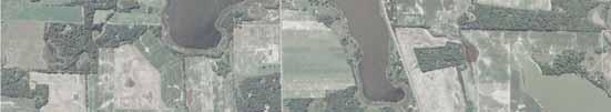
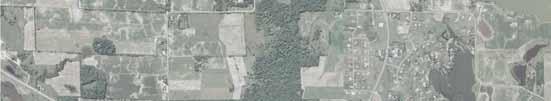
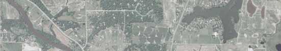
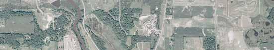
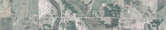
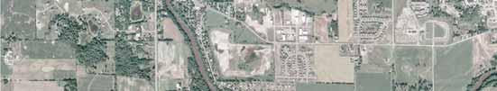

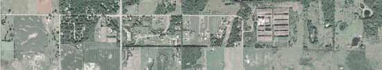
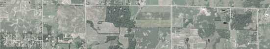
43
44
45
46


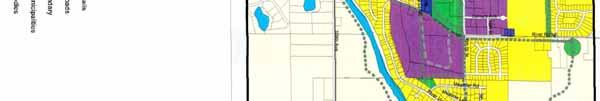


47

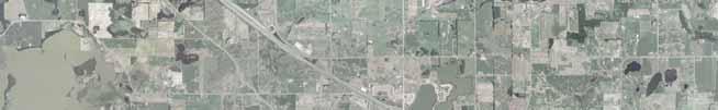


48


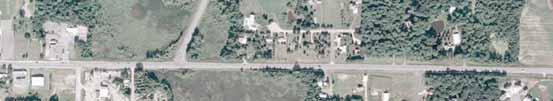
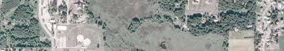
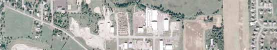
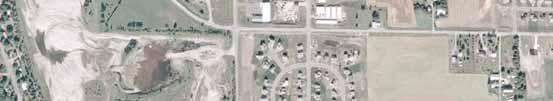

49
50
51
52
53


54
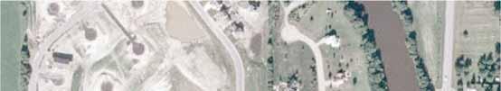
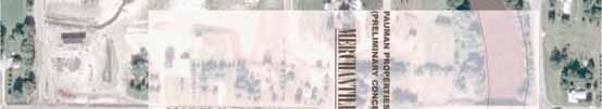
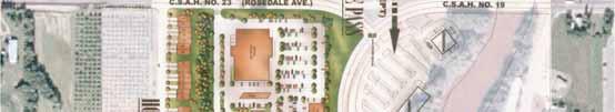
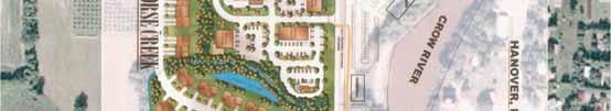

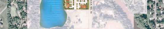

55
City of Wayzata Comprehensive Plan 2030 Transportation Chapter: Appendix A
 A1. Functional Classification Table A-1 illustrates the Metropolitan Council s detailed criteria established for the functional classification of roadways within the Twin Cities Metropolitan Area. Table
METHODOLOGY. Signalized Intersection Average Control Delay (sec/veh)
") Chapter 5 Traffic Analysis 5.1 SUMMARY US /West 6 th Street assumes a unique role in the Lawrence Douglas County transportation system. This principal arterial street currently conveys commuter traffic
Chapter 5 Traffic Analysis 5.1 SUMMARY US /West 6 th Street assumes a unique role in the Lawrence Douglas County transportation system. This principal arterial street currently conveys commuter traffic
CHAPTER 7 ACCESS MANAGEMENT. Background. Principles of Access Management. Hennepin County Transportation Systems Plan (HC-TSP)
") CHAPTER 7 ACCESS MANAGEMENT Background Principles of Access Management Hennepin County Transportation Systems Plan (HC-TSP) Chapter 7 Access Management 7.1 Background Access management has become an important
CHAPTER 7 ACCESS MANAGEMENT Background Principles of Access Management Hennepin County Transportation Systems Plan (HC-TSP) Chapter 7 Access Management 7.1 Background Access management has become an important
JONESBORO HIGHWAY 63 HIGHWAY 18 CONNECTOR STUDY
 JONESBORO HIGHWAY 63 HIGHWAY 18 CONNECTOR STUDY Craighead County May 2007 JONESBORO HIGHWAY 63 HIGHWAY 18 CONNECTOR STUDY Craighead County May 2007 Prepared by Planning and Research Division Arkansas State
Intersection Traffic Control Feasibility Study
 Intersection Traffic Control Feasibility Study CSAH 9 at CSAH 60 (185th Avenue) Prepared For: Dakota County Transportation Department Western Service Center 14955 Galaxie Avenue, 3rd Floor Apple Valley,
Traffic Impact Study. Westlake Elementary School Westlake, Ohio. TMS Engineers, Inc. June 5, 2017
 TMS Engineers, Inc. Traffic Impact Study Westlake Elementary School Westlake, Ohio June 5, 2017 Prepared for: Westlake City Schools - Board of Education 27200 Hilliard Boulevard Westlake, OH 44145 TRAFFIC
5.0 Roadway System Plan
 Southwest Boise Transportation Study Page 16 5.0 Roadway System Plan The Roadway System Plan outlines roadway improvements in the Initial Study Area. It forecasts future deficiencies on the arterial system,
TRANSPORTATION ANALYSIS REPORT US Route 6 Huron, Erie County, Ohio
 TRANSPORTATION ANALYSIS REPORT US Route 6 Huron, Erie County, Ohio December 12, 2012 Prepared for: The City of Huron 417 Main Huron, OH 44839 Providing Practical Experience Technical Excellence and Client
#!! "$% ##! &! # '#! % $ #!
 Executive Summary US Highway 16 (US 16) is the primary corridor connecting Rapid City to the Black Hills region. It serves a growing population of commercial and residential traffic, as well as seasonal
TRAFFIC STUDY. Birch Bluff Road / Pleasant Avenue 01/15/2018. City of Tonka Bay 4901 Manitou Road Tonka Bay, MN WSB PROJECT NO.
 TRAFFIC STUDY Birch Bluff Road / Pleasant Avenue 01/15/2018 City of Tonka Bay 4901 Manitou Road Tonka Bay, MN 55331 WSB PROJECT NO. 10805-000 Birch Bluff Road/ Pleasant Avenue Traffic Study For: City of
Chapter 4 Traffic Analysis
 Chapter 4 Traffic Analysis PURPOSE The traffic analysis component of the K-68 Corridor Management Plan incorporates information on the existing transportation network, such as traffic volumes and intersection
Appendix C. NORTH METRO STATION AREA TRAFFIC IMPACT STATEMENT 88th Avenue Station
 Appendix C NORTH METRO STATION AREA TRAFFIC IMPACT STATEMENT 88th Avenue Station Prepared for: Regional Transportation Department and URS Corporation as part of the North Metro EIS David Evans and Associates,
4. ENVIRONMENTAL IMPACT ANALYSIS 9. TRANSPORTATION AND TRAFFIC
 4. ENVIRONMENTAL IMPACT ANALYSIS 9. TRANSPORTATION AND TRAFFIC 4.9.1 INTRODUCTION The following section addresses the Proposed Project s impact on transportation and traffic based on the Traffic Study
TRAFFIC IMPACT STUDY COMPREHENSIVE UPDATE TOWN OF THOMPSON S STATION, TENNESSEE PREPARED FOR: THE TOWN OF THOMPSON S STATION
 TRAFFIC IMPACT STUDY COMPREHENSIVE UPDATE TOWN OF THOMPSON S STATION, TENNESSEE PREPARED FOR: THE TOWN OF THOMPSON S STATION Transportation Consultants, LLC 1101 17 TH AVENUE SOUTH NASHVILLE, TN 37212
Highway 49, Highway 351 and Highway 91 Improvements Feasibility Study Craighead County
 Highway 49, Highway 351 and Highway 91 Improvements Feasibility Study Craighead County Executive Summary March 2015 Highway 49, Highway 351 and Highway 91 Improvements Feasibility Study Craighead County
Owl Canyon Corridor Project Overview and Summary
 Owl Canyon Corridor Project Overview and Summary December 22, 2008 The Owl Canyon corridor (generally the connection between the I-25 / Larimer County Road 70 interchange and the US 287 / Larimer County
Roundabout Feasibility Memorandum
 Roundabout Feasibility Memorandum To From Gwen Pipkin Bill Howell Date June 18, 2013 Subject Roundabout Feasibility Study SR 29 PD&E Study From Oil Well Road to SR 82 Collier County, FL FPID 417540-1-22-01
APPENDIX G: INTERSECTION NEEDS AT OKEECHOBEE BOULEVARD
 APPENDIX G: INTERSECTION NEEDS AT OKEECHOBEE BOULEVARD INTERSECTION NEEDS AT SR 7 and OKEECHOBEE BOULEVARD SR 7 Extension Project Development and Environment (PD&E) Study From Okeechobee Boulevard (SR
DRAFT. Corridor study. Honeysuckle Road. October Prepared for the City of Dothan, AL. Prepared by Gresham, Smith and Partners
 DRAFT Corridor study Honeysuckle Road October 2017 Prepared for the City of Dothan, AL Prepared by TABLE OF CONTENTS SECTION I... 1 STUDY SUMMARY... 1 INTRODUCTION... 1 CONCLUSIONS... 5 SECTION II... 7
ADOT Statewide Bicycle and Pedestrian Program Summary of Phase IV Activities APPENDIX B PEDESTRIAN DEMAND INDEX
 ADOT Statewide Bicycle and Pedestrian Program Summary of Activities APPENDIX B PEDESTRIAN DEMAND INDEX May 24, 2009 Pedestrian Demand Index for State Highway Facilities Revised: May 29, 2007 Introduction
Capital Region Council of Governments
 March 23, 2018 Capital Region Council of Governments PROJECT CONCEPT REPORT Realignment of Swamp and Northfield Road s approaches to Route 44 (Boston Turnpike) Town of Coventry SUMMARY: The Town of Coventry
Chapter 5 FUNCTIONAL CLASSIFICATION
 Chapter 5 FUNCTIONAL CLASSIFICATION Functional classification is a system by which streets and roadways may be distinguished by types according to their function within the entire transportation network.
TRAFFIC IMPACT STUDY. Creekside Thornton, Colorado. For. August 2015 November 2015 Revised: August Prepared for:
 TRAFFIC IMPACT STUDY For Creekside Thornton, Colorado August 215 November 215 Revised: August 216 Prepared for: Jansen Strawn Consulting Engineers 45 West 2 nd Avenue Denver, Colorado 8223 Prepared by:
Subject: Solberg Avenue / I-229 Grade Separation: Traffic Analysis
 MEMORANDUM Transportation Bill Troe, AICP Jason Carbee, AICP 12120 Shamrock Plaza Suite 300 Omaha, NE 68154 (402) 334-8181 (402) 334-1984 (Fax) To: Project File Date: Subject: Solberg Avenue / I-229 Grade
Traffic Impact Analysis Walton Acres at Riverwood Athletic Club Clayton, NC
 Traffic Impact Analysis Walton Acres at Riverwood Athletic Club Clayton, NC 1. TABLE OF CONTENTS INTRODUCTION...1 1.1. Site Location and Study Area...1 1.2. Proposed Land Use and Site Access...2 1.3.
Traffic Impact Study. Roderick Place Columbia Pike Thompson s Station, TN. Transportation Group, LLC Traffic Engineering and Planning
 F i s c h b a c h Transportation Group, LLC Traffic Engineering and Planning Traffic Impact Study Roderick Place Columbia Pike Thompson s Station, TN Prepared March 2016 Ms. Gillian L. Fischbach, P.E.,
Chapter 6: Transportation
 Chapter 6: Transportation I. INTRODUCTION The purpose of the Transportation Plan element of the Comprehensive Plan is to provide guidance to the City of North Mankato, as well as existing and future landowners
City of Homewood Transportation Plan
 City of Homewood Transportation Plan Prepared for: City of Homewood, Alabama Prepared by: Skipper Consulting, Inc. May 2007 TABLE OF CONTENTS INTRODUCTION... 1 BACKGROUND INFORMATION... 1 EXISTING TRANSPORTATION
King Soopers #116 Thornton, Colorado
 Traffic Impact Study King Soopers #116 Thornton, Colorado Prepared for: Galloway & Company, Inc. 1.0 EXECUTIVE SUMMARY King Soopers #116, a grocery marketplace anchored commercial development, is proposed
Executive Summary June 2015
 Executive Summary June 2015 Highway 112 Corridor Study Benton and Washington Counties Executive Summary June 2015 Prepared by Transportation Planning and Policy Division Arkansas State Highway and Transportation
Date: September 7, Project #: Re: Spaulding Youth Center Northfield, NH Property. Traffic Impact Study
 To: Ms. Susan C. Ryan Spaulding Youth Center 72 Spaulding Road Northfield, NH 03276 Date: September 7, 2017 Project #: 52455.00 From: Robin Bousa Director of Transportation Systems Re: Spaulding Youth
Existing Conditions. Date: April 16 th, Dan Holderness; Coralville City Engineer Scott Larson; Coralville Assistant City Engineer
 Date: April 16 th, 2015 To: From: Re: Dan Holderness; Coralville City Engineer Scott Larson; Coralville Assistant City Engineer Darian Nagle-Gamm, Traffic Engineering Planner Highway 6 (2 nd Street) /
Welcome to the Public Meeting. Red Hill Business Park South Transportation Master Plan Addendum. December 4, :00 p.m. to 8:00 p.m.
 Welcome Welcome to the Transportation Master Plan Addendum December 4, 2012 6:00 p.m. to 8:00 p.m. Please sign-in Background PIC#1 Public Information Centre #1 (PIC#1) was held on June 25, 2012. Feedback
Project Report. South Kirkwood Road Traffic Study. Meadows Place, TX October 9, 2015
 Meadows Place, TX October 9, 2015 Contents 1 Introduction... 1 2 Data Collection... 1 3 Existing Roadway Network... 2 4 Traffic Volume Development... 2 5 Warrant Analysis... 3 6 Traffic Control Alternative
A plan for improved motor vehicle access on Railroad Avenue in Provincetown
 A plan for improved motor vehicle access on Railroad Avenue in Provincetown February 2011 A plan for improved motor vehicle access on Railroad Avenue in Provincetown INTRODUCTION AND PROBLEM IDENTIFICATION
Clackamas County Comprehensive Plan
 ROADWAYS The County s road system permits the movement of goods and people between communities and regions, using any of a variety of modes of travel. Roads provide access to virtually all property. They
Welcome to the Open House
 Leslie Street Between 19 th Avenue and Stouffville Road Addendum to Class Environmental Assessment Study Welcome to the Open House Please sign in at the front desk. March 28, 2017 Richmond Green Sports
TRAFFIC STUDY GUIDELINES Clarksville Street Department
 TRAFFIC STUDY GUIDELINES Clarksville Street Department 9/1/2009 Introduction Traffic studies are used to help the city determine potential impacts to the operation of the surrounding roadway network. Two
CITY OF ALPHARETTA DOWNTOWN MASTER PLAN TRAFFIC EVALUATION
 CITY OF ALPHARETTA DOWNTOWN MASTER PLAN TRAFFIC EVALUATION June 2015 CITY OF ALPHARETTA DOWNTOWN MASTER PLAN TRAFFIC EVALUATION Introduction The Alpharetta Downtown Master Plan was developed in the fall
Roadway Classification Design Standards and Policies. Pueblo, Colorado November, 2004
 Roadway Classification Design Standards and Policies Pueblo, Colorado November, 2004 Table of Contents Page Chapter 1. General Provisions 1.1 Jurisdiction 3 1.2 Purpose and Intent 3 1.3 Modification 3
Project Update May 2018
 Project Update May 2018 Dakota County, in cooperation with the City of Lakeville, is planning to reconstruct 202 nd Street West (County Road 50) from Holyoke Avenue to Cedar Avenue (County Road 23). 202
Donahue Drive Corridor Traffic Operational Evaluation
 Donahue Drive Corridor Traffic Operational Evaluation PREPARED FOR: THE CITY OF AUBURN PREPARED BY: JANUARY 2007 Donahue Drive Corridor Study--Auburn, Alabama TABLE OF CONTENTS Introduction... 1 Background
3.0 Future Conditions
 3.0 Future Conditions In order to be able to recommend appropriate improvements to the transportation system of the Town, it is important to first understand the nature and volume of traffic that is expected
Transportation Analysis and Plan
 The City of Waconia is a growing community that will need many miles of additional collector and local streets to serve the development that is forecast. This plan will examine ways to provide those improvements
4.0 ACCESS CONTROL PLAN - SH 14 (JEFFERSON STREET/RIVERSIDE AVENUE)
") 4.1 Existing Conditions Roadway Physical Characteristics Typical Sections Jefferson Street 4.0 ACCESS CONTROL PLAN - SH 14 (JEFFERSON STREET/RIVERSIDE AVENUE) The existing typical cross-section for SH
4.1 Existing Conditions Roadway Physical Characteristics Typical Sections Jefferson Street 4.0 ACCESS CONTROL PLAN - SH 14 (JEFFERSON STREET/RIVERSIDE AVENUE) The existing typical cross-section for SH
Traffic Circulation Study for Neighborhood Southwest of Mockingbird Lane and Airline Road, Highland Park, Texas
 ARIZONA TEXAS NEW MEXICO OKLAHOMA February 13, 2015 Mr. Meran Dadgostar P.E., R.S. Town of Highland Park 4700 Drexel Dr. Highland Park, Texas 75205 Re: Traffic Circulation Study for Neighborhood Southwest
APPENDIXB. Traffic Operations Technical Memorandum
 APPENDIXB Traffic Operations Technical Memorandum Environmental Assessment - Lincoln County, SD 85 th Street: Sundowner Avenue to Louise Avenue November 2017 MEMORANDUM Transportation Jim Kollbaum, PE
ENHANCED PARKWAY STUDY: PHASE 2 CONTINUOUS FLOW INTERSECTIONS. Final Report
 Preparedby: ENHANCED PARKWAY STUDY: PHASE 2 CONTINUOUS FLOW INTERSECTIONS Final Report Prepared for Maricopa County Department of Transportation Prepared by TABLE OF CONTENTS Page EXECUTIVE SUMMARY ES-1
City of Memphis On-Street Parking Modification Guidelines
 City of Memphis Effective Date: December 1, 2013 Bicycle/Pedestrian Program 125 N. Main Street Memphis, TN 38103 (901) 576-6710 www.bikepedmemphis.com City of Memphis Executive Summary It is current practice
Highway 111 Corridor Study
 Highway 111 Corridor Study June, 2009 LINCOLN CO. HWY 111 CORRIDOR STUDY Draft Study Tea, South Dakota Prepared for City of Tea Sioux Falls Metropolitan Planning Organization Prepared by HDR Engineering,
TRAFFIC IMPACT STUDY CRITERIA
 Chapter 6 - TRAFFIC IMPACT STUDY CRITERIA 6.1 GENERAL PROVISIONS 6.1.1. Purpose: The purpose of this document is to outline a standard format for preparing a traffic impact study in the City of Steamboat
FINAL Albertville Business Park AUAR Update Traffic Study
 FINAL Albertville Business Park AUAR Update Traffic Study Prepared for City of Albertville, MN July 20, 2017 SRF No. 10060.00 Table of Contents Introduction... 1 Existing Conditions... 1 Data Collection...
MoPac South: Impact on Cesar Chavez Street and the Downtown Network
 MoPac South: Impact on Cesar Chavez Street and the Downtown Network Prepared by: The University of Texas at Austin Center for Transportation Research Prepared for: Central Texas Regional Mobility Authority
INTRODUCTION THOROUGHFARE SYSTEM CLASSIFICATIONS
 INTRODUCTION The thoroughfare plan will assist public officials in the development of a specialized system for efficient and safe movement of vehicular traffic while minimizing potential conflicts with
Traffic Study 30th Street Specific Area Plan
 Prepared for HDR Engineering, Inc. River Quarry at Park Center 412 E. Parkcenter Blvd., Suite 100 Boise, ID 83706-6659 Prepared by 5561 N Glenwood Street, Suite B Boise, ID 83714-1336 208-898-0012 www.parametrix.com
University Hill Transportation Study Technical Memorandum Alternatives Modeling and Analysis May 2007
 Technical Memorandum May 2007 Syracuse Metropolitan Transportation Council Edwards and Kelcey with Wallace Roberts and Todd Alta Planning and Design CONTENTS SECTION ONE- INTRODUCTION...1 SECTION TWO-
Title. Metropolitan Council Transportation Committee December 12, Brad Larson Metro District MnDOT
 Title Metropolitan Council Transportation Committee December 12, 2016 Evaluating the potential for Bus Rapid Transit and MnPASS Express Lanes in the southwest Metro Brad Larson Metro District MnDOT Background
Main-McVay Transit Study: Phase 2 Options Definition and High Level Constraints Evaluation
 Main-McVay Transit Study: Phase 2 Options Definition and High Level Constraints Evaluation APRIL 2016 A collaborative study between: For Additional Information or to Comment If you would like additional
TRAFFIC IMPACT ANALYSIS
 TRAFFIC IMPACT ANALYSIS FOR THE CHAMPAIGN UNIT#4 SCHOOL DISTRICT PROPOSED HIGH SCHOOL (SPALDING PARK SITE) IN THE CITY OF CHAMPAIGN Final Report Champaign Urbana Urbanized Area Transportation Study 6/24/2014
Traffic Impact Analysis Chatham County Grocery Chatham County, NC
 Chatham County Grocery Chatham County, NC TABLE OF CONTENTS 1. INTRODUCTION... 1 1.1. Location and Study Area... 1 1.2. Proposed Land Use and Access... 2 1.3. Adjacent Land Uses... 2 1.4. Existing ways...
ACTION TRANSMITTAL No
 Transportation Advisory Board of the Metropolitan Council of the Twin Cities ACTION TRANSMITTAL No. 2016-15 DATE: January 14, 2016 TO: TAC Planning Committee PREPARED BY: Steven Elmer (651) 602-1756 SUBJECT:
APPENDIX 2 LAKESHORE ROAD TRANSPORTATION REVIEW STUDY EXECUTIVE SUMMARY
 APPENDIX 2 LAKESHORE ROAD TRANSPORTATION REVIEW STUDY EXECUTIVE SUMMARY Appendix 2 City of Mississauga Lakeshore Road FINAL REPORT Transportation Review Study December 2010 EXECUTIVE SUMMARY Study Purpose
M-58 HIGHWAY ACCESS MANAGEMENT STUDY Mullen Road to Bel-Ray Boulevard. Prepared for CITY OF BELTON. May 2016
 M-58 HIGHWAY ACCESS MANAGEMENT STUDY Prepared for CITY OF BELTON By May 2016 Introduction Missouri State Highway 58 (M-58 Highway) is a major commercial corridor in the City of Belton. As development has
Recommended Roadway Plan Section 2 - Land Development and Roadway Access
 Recommended Roadway Plan Section 2 - Land Development and Roadway Access SECTION 2 Land Development and Roadway Access 2.1 Land Use and Access Management The Federal Highway Administration (FHWA) defines
BUSINESS OF THE CITY COUNCIL CITY OF MERCER ISLAND, WA
 BUSINESS OF THE CITY COUNCIL CITY OF MERCER ISLAND, WA AB 4087 May 1, 2006 Regular Business PEAK PROJECT UPDATE - CITY RELATED ISSUES Proposed Council Action: Receive update. No action required. DEPARTMENT
Glenn Avenue Corridor Traffic Operational Evaluation
 Glenn Avenue Corridor Traffic Operational Evaluation PREPARED FOR: THE CITY OF AUBURN PREPARED BY: DECEMBER 2007 Glenn Avenue Corridor Study--Auburn, Alabama TABLE OF CONTENTS Introduction... 1 Background
Paul Huston, P.E., Design-Build Coordinator Chuck Gonderinger, HDR Engineering. Minnesota Department of Transportation (the Department)
") To: From: Paul Huston, P.E., Design-Build Coordinator Chuck Gonderinger, HDR Engineering Date: March 20, 2001 Subject: Roadway Geometric Design Criteria Project: TH 14/218 Design-Build Project, SP 7408-29,
To: From: Paul Huston, P.E., Design-Build Coordinator Chuck Gonderinger, HDR Engineering Date: March 20, 2001 Subject: Roadway Geometric Design Criteria Project: TH 14/218 Design-Build Project, SP 7408-29,
ACCESS MANAGEMENT PLAN: BLUFFTON PARKWAY BLUFFTON PARKWAY: PHASE FOUR TOWN OF BLUFFTON & BEAUFORT COUNTY, SC
 ACCESS MANAGEMENT PLAN: BLUFFTON PARKWAY BLUFFTON PARKWAY: PHASE FOUR TOWN OF BLUFFTON & BEAUFORT COUNTY, SC Prepared for: Beaufort County & Town of Bluffton Prepared by: SRS ENGINEERING, LLC 801 Mohawk
List of Attachments. Location Map... Site Plan... City of Lake Elsinore Circulation Element... City of Lake Elsinore Roadway Cross-Sections...
 List of Attachments Exhibits Location Map... Site Plan... City of Lake Elsinore Circulation Element... City of Lake Elsinore Roadway Cross-Sections... Existing Lane Geometry and Traffic Controls... Existing
Operational Comparison of Transit Signal Priority Strategies
 Operational Comparison of Transit Signal Priority Strategies Revision Submitted on: November, 0 Author: Adriana Rodriguez, E.I Assistant Engineer Parsons Brinckerhoff 0 South Orange Avenue, Suite 00 Orlando,
Traffic Calming Policy
 Article I. Purpose and Goal. The purpose of this policy is to establish criteria and procedures the City will use to evaluate requests for, and if appropriate, implement traffic calming measures. Neighborhood
Appendix A. Functional Classification
 Appendix A Functional Classification 1 Functional Classification Roadways serve two primary functions providing access to land uses, and providing mobility to travelers. The functional classification of
Committed to Service
 Development Services Department Committed to Service TO: FROM: Ada County Highway District Commissioners Mindy Wallace, AICP Planner III COMISSION HEARING: January 27, 2016 SUBJECT: Syringa Valley Specific
8 PROPOSED ROUNDABOUT DUFFERIN STREET AND KING VAUGHAN ROAD INTERSECTION CITY OF VAUGHAN
 8 PROPOSED ROUNDABOUT DUFFERIN STREET AND KING VAUGHAN ROAD INTERSECTION CITY OF VAUGHAN The Transportation Services Committee recommends the adoption of the recommendation contained in the following report
3.0 PROJECT DESCRIPTION
 The following section of the Draft EIR contains a description of the proposed Elk Grove Boulevard/SR 99 Interchange Modification project, consistent with the requirements of CEQA Guidelines Section 15124.
CHAPTER THREE MOBILITY
 CHAPTER THREE MOBILITY 70 MAJOR THOROUGHFARES Operations. The City of Ames is served by a combination of federal, state and local highways/streets that are interlinked in creating a regional and inter-city
Route 7 Corridor Study
 Route 7 Corridor Study Executive Summary Study Area The following report analyzes a segment of the Virginia State Route 7 corridor. The corridor study area, spanning over 5 miles in length, is a multi
MEMORANDUM. To: 1.0 PURPOSE
 MEMORANDUM To: Scott Holland, Elements Architecture From: Brian Grover, Dudek Date: July 16, 2014 1.0 PURPOSE In response to the November 4, 2013 request (RE: Incomplete Application Southern California
TRAFFIC IMPACT STUDY And A TRAFFIC SIGNAL WARRANT ANALYSIS FOR A SENIOR LIVING AND APARTMENT DEVELOPMENT
 TRAFFIC IMPACT STUDY And A TRAFFIC SIGNAL WARRANT ANALYSIS FOR A SENIOR LIVING AND APARTMENT DEVELOPMENT DEERFIELD TOWNSHIP, WARREN COUNTY, OHIO Nantucket Circle and Montgomery Road () Prepared for: ODLE
Los Altos Hills Town Council - June 18, 2015 Palo Alto City Council June 22, AGENDA ITEM #2.B Presentation
 Los Altos Hills Town Council - June 18, 2015 Palo Alto City Council June 22, 2015 AGENDA ITEM #2.B Presentation Previous Presentations Los Altos Hills Town Council in May 2014 and February 2015 Palo Alto
4APNOIPF Vh, YII PTC CITY COUNCIL AGENDA REPORT. Honorable Mayor and City Council Members. 8K TH 63 River Crossing Bridge Replacement Project
 City of RE 4APNOIPF Vh, X` W\ YII PTC ING, CITY COUNCIL AGENDA REPORT Council Meeting Date: September 26, 2016 To: From: Agenda Item: Honorable Mayor and City Council Members Ron Rosenthal, Engineering
CHAPTER 7 CIRCULATION
 CHAPTER 7 CIRCULATION A township s transportation network links its population with the surrounding communities. Transportation networks, including public and private, provide the means by which township
Figure 1: East West Connector Alignment Alternatives Concept Drawing
 Page 2 of 9 Figure 1: East West Connector Alignment Alternatives Concept Drawing The Montebello Drive extension will run north south and connect Wilsonville Road to the Boones Ferry Road to Brown Road
DUNBOW ROAD FUNCTIONAL PLANNING
 DUNBOW ROAD FUNCTIONAL PLANNING Final Report August 3, 216 #31, 316 5th Avenue NE Calgary, AB T2A 6K4 Phone: 43.273.91 Fax: 43.273.344 wattconsultinggroup.com Dunbow Road Functional Planning Final Report
Transportation Impact Study for Abington Terrace
 Transportation Impact Study for Abington Terrace Abington Township, Montgomery County, PA Sandy A. Koza, P.E., PTOE PA PE License Number PE059911 Prepared by McMahon Associates, Inc. 425 Commerce Drive,
TOWN OF CHAPEL HILL POLICY AND PROCEDURES FOR TRAFFIC CALMING MEASURES
 TOWN OF CHAPEL HILL POLICY AND PROCEDURES FOR TRAFFIC CALMING MEASURES (Adopted by the Town Council on June 30, 2004) (Revised December 6, 2010) (Revised February 8, 2016) POLICY AND PROCEDURES FOR TRAFFIC
DRAFT BUENA VISTA 2020 TRANSPORTATION PLAN
 DRAFT BUENA VISTA 2020 TRANSPORTATION PLAN DEVELOPED BY THE TRANSPORTATION PLANNING DIVISION OF THE VIRGINIA DEPARTMENT OF TRANSPORTATION IN COOPERATION WITH THE U.S. DEPARTMENT OF TRANSPORTATION, FEDERAL
Evaluation of M-99 (Broad Street) Road Diet and Intersection Operational Investigation
 Road Diet and Intersection Operational Investigation") Evaluation of M-99 (Broad Street) Road Diet and Intersection Operational Investigation City of Hillsdale, Hillsdale County, Michigan June 16, 2016 Final Report Prepared for City of Hillsdale 97 North Broad
Evaluation of M-99 (Broad Street) Road Diet and Intersection Operational Investigation City of Hillsdale, Hillsdale County, Michigan June 16, 2016 Final Report Prepared for City of Hillsdale 97 North Broad
NEIGHBORHOOD TRAFFIC CALMING POLICY
 NEIGHBORHOOD TRAFFIC CALMING POLICY I. PURPOSE The City of Kent continually strives to strengthen and protect its neighborhoods by improving the quality of life in residential areas. Traffic conditions
APPENDIX E: Transportation Technical Report
 New Jersey Pennsylvania Lackawanna Cut-Off Passenger Rail Service Reston Project Environmental Assessment APPENDIX E: Transportation Technical Report E.1 Introduction As part of the overall environmental
TRASBURG RANSPORTATION
 TRASBURG RANSPORTATION LAN DEVELOPED BY THE TRANSPORTATION PLANNING DIVISION OF THE VIRGINIA DEPARTMENT OF TRANSPORTATION IN COOPERATION WITH THE U.S. DEPARTMENT OF TRANSPORTATION, FEDERAL HIGHWAY ADMINISTRATION
5858 N COLLEGE, LLC N College Avenue Traffic Impact Study
 5858 N COLLEGE, LLC nue Traffic Impact Study August 22, 2016 Contents Traffic Impact Study Page Preparer Qualifications... 1 Introduction... 2 Existing Roadway Conditions... 5 Existing Traffic Conditions...
Bridge Street Corridor Study Report
 Bridge Street Corridor Study Report Prepared for: Prepared by: BRIDGE STREET CORRIDOR STUDY REPORT PREPARED FOR: CITY OF ARROYO GRANDE COMMUNITY DEVELOPMENT DEPARTMENT 300 EAST BRANCH STREET ARROYO GRANDE,
Exhibit 1 PLANNING COMMISSION AGENDA ITEM
 Exhibit 1 PLANNING COMMISSION AGENDA ITEM Project Name: Grand Junction Circulation Plan Grand Junction Complete Streets Policy Applicant: City of Grand Junction Representative: David Thornton Address:
SECTION 1 - TRAFFIC PLANNING
 SECTION 1 - TRAFFIC PLANNING 1.1 TRAFFIC OPERATIONS 1.1.1 Roadway Functional Classification The Multnomah County Comprehensive Framework Plan s Policy 34: Trafficways and the Functional Classification
APPENDIX F SUPPLEMENTAL TRAFFIC DATA
 APPENDIX F SUPPLEMENTAL TRAFFIC DATA Environmental and Planning Consultants 440 Park Avenue South 7th Floor New York, NY 10016 tel: 212 696-0670 fax: 212 213-3191 www.akrf.com Draft Memorandum To: Michael
Policy Number: Effective: 07/11/14 Responsible Division: Planning Date: 07/11/2014 FUNCTIONAL CLASSIFICATION AMENDMENT POLICY
 Policy Number: 2014-025 Effective: 07/11/14 Responsible Division: Planning Date: 07/11/2014 FUNCTIONAL CLASSIFICATION AMENDMENT POLICY POLICY STATEMENT: The Northeast Ohio Areawide Coordinating Agency
Walmart (Store # ) 60 th Street North and Marion Road Sioux Falls, South Dakota
 60 th Street North and Marion Road Sioux Falls, South Dakota") Walmart (Store #4865-00) 60 th Street North and Marion Road Sioux Falls, South Dakota Prepared for: Wal-Mart Stores, Inc. Bentonville, Arkansas Prepared by: Kimley-Horn and Associates, Inc. ã2013 Kimley-Horn
Walmart (Store #4865-00) 60 th Street North and Marion Road Sioux Falls, South Dakota Prepared for: Wal-Mart Stores, Inc. Bentonville, Arkansas Prepared by: Kimley-Horn and Associates, Inc. ã2013 Kimley-Horn
Cheyenne Metropolitan Planning Organization
 Dell Range Boulevard Corridor Study PHASE II SECTION 20 DRAFT Prepared for: Cheyenne Metropolitan Planning Organization November 20, 2015 (Section 20 is bordered by Powderhouse Road on the west, Storey
Dakota County CSAH 31. Corridor Transportation Study
 Dakota County CSAH 31 (Pilot Knob Road) Corridor Transportation Study FINAL REPORT May 10, 2007 Prepared for The City of Lakeville, The City of Apple Valley and Dakota County Prepared by SRF Consulting