APPENDIX F SUPPLEMENTAL TRAFFIC DATA
|
|
|
- Ruth Harrell
- 5 years ago
- Views:
Transcription
1 APPENDIX F SUPPLEMENTAL TRAFFIC DATA

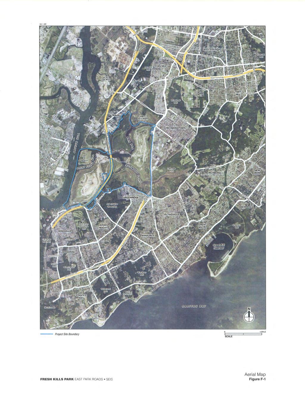
2 Environmental and Planning Consultants 440 Park Avenue South 7th Floor New York, NY tel: fax: Draft Memorandum To: Michael Marrella, New York City Department of Parks & Recreation, Fresh Kills Park Project From: Adnan Pasha, P.E., and James Seto, AKRF Date: October 6, 2009 Re: Evaluation of Proposed East Park Road Connections Purpose and Need Supporting Data cc: Robert White, AKRF A. INTRODUCTION This memorandum has been prepared to provide supporting data relative to the purpose and need for the park road connections proposed for the Fresh Kills Park East Park road system. It has been prepared in response to comments on the Fresh Kills Park East Park Roads Draft Supplemental Environmental Impact Statement DSEIS raised by the New York State Department of Environmental Conservation (DEC) regarding the purpose and need for the proposed East Park roads (in particular, the long-term projects) given that the traffic impacts would remain on the local network with the proposed project in place, and that given projected volumes of traffic, that the proposed road widths (specifically with respect to the four-lane road options) are not entirely justified. The comments also requested a clearer justification of the improvements in the traffic that would be expected with the proposed East Park Roads Project. This memorandum has therefore been prepared to provide further justification for the proposed roads with respect to the following points: Improvements in local travel time and shortened travel distances given that the proposed roads would eliminate the need for the public to drive around the large Fresh Kills property; Improvements in local traffic levels of service conditions that would otherwise not be realized without completion of park roads; and Neighborhood character benefits with respect to the reduced volumes of traffic through local communities such as the Travis neighborhood. One of the principal objectives of the proposed Fresh Kills Park circulation plan, a critical component of which in the proposed East Park roads and the connection to Richmond Avenue, is to provide improved local connectivity, specifically between Richmond Avenue, which runs along the east boundary of the project site, and the West Shore Expressway, a state highway with regional interstate connections that runs through the site. Once fully completed, the Fresh Kills Park road system will provide three AKRF, Inc. New York City Hudson Valley Region Long Island Baltimore / Washington Area New Jersey Connecticut
3 Draft Memorandum 2 October 6, 2009 connections on Richmond Avenue at Forest Hill and Richmond Hill Roads, and Yukon Avenue. The first connection at Yukon Avenue is proposed to be completed by 2016 providing access to the Confluence Loop Park Road, Creek Landing, and the West Shore Expressway. After 2016, the entire East Park road system (which could include two- or four-lane roads across East Park) will be completed providing two new connections at Richmond Hill Road and Forest Hill Road, in addition to the connection at Yukon Avenue. These three connections are necessary for improving traffic conditions along Richmond Avenue a major arterial providing connection between Richmond Parkway on the south and the Staten Island Expressway on the north which in addition to carrying the regular commuter traffic, accommodates significant traffic generated by the commercial and retail land uses (e.g., Staten Island Mall). In addition, by the EIS analysis year 2036, traffic volumes on Richmond Avenue are expected to increase significantly due to the background growth, other development (no build) projects and park generated traffic volumes. With the proposed East Park road system in place, the three proposed connections would help facilitate the flow of traffic, specifically on the heavily congested segment of Richmond Avenue between Forest Hill and Richmond Hill Roads. The East Park roads were analyzed in detail based on the City Environmental Quality Review (CEQR) methodologies in the June 2009 Fresh Kills East Park Roads Draft Supplemental Environmental Impact Statement (DSEIS). That analysis evaluated the new park road connections in terms of level-of-service (LOS), based on the CEQR criteria, and evaluation of other roadway measures-of-effectiveness (MOE), such as travel-time was not included in the DSEIS. As stated above, the purpose of this memorandum is to further explain the improvements in local traffic circulation that are expected with the proposed East Park road. As part of the environmental public review process, the DSEIS was reviewed by City and State agencies, including DEC which has the jurisdiction over the existing landfill infrastructure at the site. Therefore, as stated above, the principal goal of this memorandum is to provide supporting data and a better understanding of the purpose and need for the proposed East Park roads. B. ANALYSIS FRAMEWORK TRAFFIC VOLUMES As stated above, the proposed East Park roads would provide an alternative and more direct route between the West Shore Expressway and Richmond Avenue. In the absence of such a route, drivers will continue to have to drive around the Fresh Kills property (as they currently do) to access the West Shore Expressway. This increases travel distance and travel time, for traffic destined for West Shore Expressway from the neighboring communities of Richmond, Richmondtown, Oakwood, and New Dorp neighborhoods (see Figure F-1). In addition, in the absence of East Park roads, the corridors along the periphery of the park (i.e., Richmond Avenue, Arthur Kill Road, and Victory Boulevard/Travis Avenue) would experience more congested traffic conditions, specifically in 2036, when the overall traffic volumes in the study area will increase substantially due to the background growth, future developments and park generated traffic. These increased traffic volumes on the park periphery roads in the 2016 and 2036 future conditions without the East Park roads in place are presented in Figures F-2 through F-5 for the weekday PM and weekend midday peak hours. As shown in these figures, in the 2036 future conditions, without the proposed East Park roads, the Victory Boulevard and Arthur Kill Road corridors would experience up to approximately 950 and 1,100 additional vehicles, respectively, during the weekday and weekend peak hours, respectively. With the proposed East Park road connections in place, these additional vehicles would be dispersed to the internal park road system from Richmond Avenue without adding to the traffic levels along Victory Boulevard and Arthur Kill Road. TRAVEL TIME RUNS To estimate the increase in travel time without the East Park roads in place, travel time runs were conducted to determine current travel times as compared with the conditions under the proposed project. Five travel time runs were conducted on the corridors along the periphery of the park (i.e., Richmond
4 Draft Memorandum 3 October 6, 2009 Avenue, Arthur Kill Road, and Victory Boulevard/Travis Avenue). The results of travel time runs are discussed in detail in the proceeding sections. The travel time runs were conducted for two routes, which are the routes most likely to be travelled by the park-generated and diverted traffic. The two routes are presented in Figure F-6 and are described below. Alternate Route 1: Travis Avenue / Victory Boulevard In the absence of the proposed park road connections at Richmond Hill Road and/or Yukon Avenue, drivers would need to access the park and West Shore Expressway via Travis Avenue and Victory Boulevard. For travel time estimation purposes, vehicles were assumed to start their travel at the intersection of Richmond and Yukon Avenues. Heading northbound on Richmond Avenue, at the intersection of Draper Place, these vehicles would turn left to continue northwest on Draper Place to access Victory Boulevard via Travis Avenue. These vehicles were then assumed to continue southwest on Victory Boulevard until they reach the West Shore Expressway northbound and southbound service roads. Park-destined vehicles would continue along the southbound service road to the intersection of Wild Avenue to enter the Fresh Kills Park. Diverted traffic would access the West Shore Expressway via the existing northbound or southbound ramps. A total of five travel time runs were conducted along this route during the weekday PM and weekend (Saturday) midday peak hours to obtain travel times. Alternate Route 2: Arthur Kill Road In the absence of a park connection at Forest Hill Road and/or Yukon Avenue, drivers would be expected to access the park and West Shore Expressway via Arthur Kill Road. These vehicles are assumed to start their travel at the intersection of Richmond Avenue and Yukon Avenue, then head southbound on Richmond Avenue. From Richmond Avenue, the vehicles would continue onto Drumgoole Road West, and then travel west on Arthur Kill Road to reach the West Shore Expressway northbound and southbound service roads to reach the Fresh Kills Park and the Expressway. A total of five travel time runs were conducted along this route during the weekday PM and weekend (Saturday) midday peak hours to obtain current travel times. TRAFFIC CAPACITY ANALYSIS The DSEIS qualitatively assessed the traffic conditions in the absence of the proposed East Park roads (i.e., the No Build Alternative). However, for the purposes of this memorandum, a quantified traffic analysis was performed for the intersections located along the Fresh Kills Park perimeter roads in order to compare the LOS conditions both with-and without the proposed East Park road connections. In total, 19 intersections along the periphery of the park (previously analyzed in the FGEIS) were selected in the traffic study area (see Figure F-7) to assess the traffic conditions both with and without the East Park roads. The analysis presented in this memorandum compares the LOS conditions resulting from the construction of a single roadway connection (i.e., the Yukon Avenue Connection only) with conditions with all three road connections in place. The traffic analysis relied on the build conditions data presented in the March 2009 Fresh Kills Park FGEIS for the intersections along park s perimeter roads. The diverted and park generated traffic assumed to be using the East Park road system was added to the network in order to assess how it affects local intersections and operations along Arthur Kill road and Victory Boulevard as well as its affect on local intersections in places such as the Travis neighborhood. The analysis was performed for the weekday PM and weekend midday peak hours for the 2016 conditions with no East Park roads and the Yukon Avenue-Only Connection, and for the 2036 conditions with no East Park roads, the Yukon Avenue-Only Connection, and the Completed East Park road system. The capacity analysis was conducted as per the methodologies of the 2000 Highway Capacity Manual using Highway Capacity Software (HCS) Version 4.1f.
5 Draft Memorandum 4 October 6, Build Conditions For the 2016 condition, it is assumed that the build out of Fresh Kills Park and the roads west of East Park (including the connections and ramps associated with the West Shore Expressway) would proceed as described in the Fresh Kills Park FGEIS (March 2009). Absent the proposed East Park roads, vehicles would have to utilize the streets at the periphery of the park, including Richmond Avenue, Arthur Kill Road, Travis Avenue, and Victory Boulevard in order to access the park from the West Shore Expressway (see Table 1). Yukon Avenue Connection By 2016, the East Park roads proposed project would extend Yukon Avenue (as a two-lane park road) west into the park from its current intersection with Richmond Avenue. From there, the park road would extend across East Park to connect with the Confluence Loop Park Road near the Richmond Creek Bridge. This proposed park road would cross Landfill Section 6/7 and is referred to as the Yukon Avenue Connection in the DSEIS. The overall project generated traffic assignment inbound and outbound percentages for the park components which are expected to utilize the park connection on Richmond Avenue are presented in Appendix A to this memorandum. Table Conditions Assumptions Comparison Components 2016 Build Without East Park Roads (1) 2016 Build Yukon Avenue Only Connection (1) Fresh Kills Park Build-Out X X East Park Roads X Yukon Avenue Connection X Roads West of East Park X X WSE connections X X Note: WSE = West Shore Expressway. Source: 1. Fresh Kills Park East Park Roads DSEIS (June 2009). Therefore, for the 2016 analysis conditions, the traffic LOS and the travel time runs both with and without the proposed East Park roads were compared to the 2016 No Build traffic LOS presented in the FGEIS Build Conditions Absent the proposed East Park roads, it is assumed that the Fresh Kills Park and the roads west of East Park would be completed as described in the FGEIS (March 2009). With the build-out of Fresh Kills Park by the year 2036, an even greater number of park-generated vehicles (as compared with the year 2016) would need to utilize the streets and roadways (as described above) at the periphery of the park in order to access the park from the West Shore Expressway connections. Table Conditions Assumptions Comparison Components 2036 Build Without East Park Roads (1) 2036 Build Yukon Avenue-Only Option (1) 2036 Build Completed East Park Road System (1) Fresh Kills Build Out X X X East Park Roads X X Richmond Hill Road Connection X Yukon Avenue Connection X X Forest Hill Road Connection X Roads west of East Park X X X WSE connections X X X Note: WSE = West Shore Expressway. Source: 1. Fresh Kills Park East Park Roads DSEIS (June 2009). As described in greater detail in the DSEIS, under consideration are a number of options for completion of the East Park road system. These include two- or four-lane roads across East Park with new
6 Draft Memorandum 5 October 6, 2009 connections at Richmond Hill Road, Yukon Avenue, and Forest Hill Road, a two-lane loop road around the base of the landfill with connections at Richmond Hill Road, Yukon Avenue, and Forest Hill Road, and a Yukon Avenue only option (as a four-lane road) without the Richmond Hill Road and Forest Hill Road connections. Each of these roadway options are further described in Chapter 1, Project Description. C. ANALYSIS RESULTS TRAVEL TIME RUNS As stated above, five travel time runs were conducted on the street along the periphery of the Fresh Kills property to determine current travel times without the East Park road connections. The existing average travel times for the two routes (see Figure F-6) are summarized in Tables 3 and 4, respectively. Segment From To 1 Richmond Avenue and Richmond Avenue and Yukon Avenue Richmond Hill Road 2 Richmond Avenue and Richmond Avenue and Richmond Hill Road Draper Place 3 Richmond Avenue and Victory Boulevard and Draper Place Travis Avenue 4 Victory Boulevard and Victory Boulevard and Travis Avenue Wild Avenue 5 Victory Boulevard and Victory Boulevard and Wild Avenue WSE Service Roads 6 Victory Boulevard and Wild Avenue and WSE Service Roads WSE Service Roads 11 minutes Total Travel Time 16 seconds Note: WSE = West Shore Expressway. Source: Travel time surveys conducted by AKRF in September Segment From To A Richmond Avenue and Richmond Avenue and Yukon Avenue Forest Hill Road B Richmond Avenue and Arthur Kill Road and Forest Hill Road Drumgoole Road C Arthur Kill Road and Arthur Kill Road and Drumgoole Road Woodrow Road D Arthur Kill Road and Arthur Kill Road and Woodrow Road Arden Avenue E Arthur Kill Road and Arthur Kill Road and Arden Avenue WSE NB Service Road Subtotal Travel Time Table 3 Existing Average Travel Times: Alternate Route 1 Average Travel Time Weekday PM Weekend Midday Peak Period Peak Period 2 minutes 3 minutes 49 seconds 13 seconds 2 minutes 2 minutes 52 seconds 28 seconds 2 minutes 2 minutes 57 seconds 20 seconds 1 minute 1 minute 20 seconds 44 seconds 1 minute 1 minute 18 seconds 3 seconds 33 seconds 40 seconds 11 minutes 28 seconds Table 4 Existing Average Travel Times: Alternate Route 2 Average Travel Time Weekday PM Weekend Midday Peak Period Peak Period 51 seconds 1 minute 25 seconds 2 minutes 1 minute 47 seconds 55 seconds 1 minute 1 minute 28 seconds 34 seconds 2 minutes 2 minute 33 seconds 10 seconds 1 minute 1 minute 14 seconds 20 seconds 8 minute 8 minute 53 seconds 24 seconds 1 minute 1 minute 24 seconds 22 seconds F Arthur Kill Road and WSE Mainline at WSE NB Service Road Muldoon Avenue G WSE Mainline at WSE Mainline south of WSE Mainline Fresh Kills Creek 42 seconds 50 seconds Total Travel Time 10 minutes 10 minutes 59 seconds 36 seconds Notes: WSE = West Shore Expressway; NB = northbound. Source: Travel time surveys conducted by AKRF in September 2009.
7 Draft Memorandum 6 October 6, BUILD CONDITIONS Absent the proposed East Park road connections at the intersection of Richmond and Yukon Avenues, drivers (from east of Richmond Avenue) seeking to access the West Shore Expressway and the park would have to travel routes identified above. Park-destined vehicles would either travel north to reach the Expressway entrances at Victory Boulevard or south to reach the Expressway entrances at Arden Avenue. 1 On average, the Victory Boulevard/Travis Avenue route adds approximately 3.3 miles and an additional 11 minutes to the average travel time in the absence of the proposed East Park road connections. As for the Arthur Kill Road/Arden Avenue route, it adds approximately 2.8 miles and an additional 8 minutes to the average travel time in the absence of the proposed East Park road connections. With the proposed East Park roads and the park entrances at the Richmond and Yukon Avenues, drivers at the Richmond Avenue/Yukon Avenue intersection would continue west on the Yukon Avenue Connection park road to reach the Confluence Loop Park Road where they could either access the confluence area of the park or the northbound and the southbound West Shore Expressway. To reach the northbound West Shore Expressway, drivers would continue through onto the north leg of the Confluence Loop Park Road to reach the West Shore Expressway northbound service road on the east side of the West Shore Expressway mainline. To reach the southbound West Shore Expressway, drivers would make a left turn to reach the south leg of the Confluence Loop Park Road, across the Richmond Creek Bridge, under the West Shore Expressway, and turn left onto the West Shore Expressway southbound service road. The distance for drivers from this intersection to reach the northbound and southbound West Shore Expressway utilizing the East Park roads would be approximately 1.3 miles, resulting in approximately 3 minutes of travel time, assuming a 30 mph speed limit on the internal park roads. The travel distance and time comparison for the 2016 conditions are presented in Table 5a and 5b. Table 5a 2016 Build Conditions: Estimated Travel Distance Comparison To Without East Park Roads Yukon Avenue-Only Connection From WSE (Victory Boulevard) WSE (Arden Avenue) WSE (Confluence Loop Road) Richmond Avenue and Yukon Avenue 3.3 miles 2.8 miles 1.3 miles Note: Approximate travel distances based on Fresh Kills Park East Park Roads DSEIS (June 2009) and GIS aerials. Source: AKRF, Inc., October Table 5b 2016 Build Conditions: Estimated Travel Time Comparison To Without East Park Roads Yukon Avenue-Only Connection * From WSE (Victory Boulevard) WSE (Arden Avenue) WSE (Confluence Loop Road) Richmond Avenue and Yukon Avenue 11 minutes 8 minutes 3 minutes Note: * Estimated travel time assumes free flow speeds with no traffic controls on internal park road intersections. In the future conditions with the traffic controls in place, the estimated travel time based on free flow speeds is expected to increase by an additional 1 to 2 minutes. Source: AKRF, Inc., October With the reconfiguration of the West Shore Expressway connections and ramps in the future conditions.
8 Draft Memorandum 7 October 6, BUILD CONDITIONS As described in the preceding sections, under consideration are several options for the completed 2036 East Park road system. The travel time savings for each of these options (compared with the Build conditions without the East Park roads) are discussed in the following sections. Completed East Park Road System (Four-Lane Park Roads) Yukon Avenue Connection Absent the proposed East Park roads, the distance drivers would need to travel around the Fresh Kills property from the intersection of Richmond Avenue and Yukon Avenue to reach the West Shore Expressway and the park would be the same as described in the above section for the 2016 Build conditions. Likewise, with the Yukon Avenue Connection in place, the distance to travel across the park roads to reach the West Shore Expressway service roads would also be the same. Forest Hill Road Connection Absent the proposed East Park roads, drivers at the intersection of Richmond Avenue and Forest Hill Road seeking access to the West Shore Expressway and the park, would need to travel south on Richmond Avenue to reach the West Shore Expressway entrances at Arden Avenue. This more limited road network would require them to travel south on Richmond Avenue through Drumgoole Road to reach Arthur Kill Road. Drivers would turn west along Arthur Kill Road for a distance of about 1.6 miles to reach northbound or southbound entrances to the West Shore Expressway at the Arden Avenue. Thus, the total distance is about 2.4 miles (a travel time of approximately 7 minutes) to get around the Fresh Kills property. However, with the Richmond Avenue and Forest Hill Road connection in place, drivers could continue onto the Forest Hill Connection to reach the Confluence Loop Park Road. To access the northbound West Shore Expressway, drivers would turn north and cross the Main Creek Bridge to the north leg of the Confluence Loop Park Road to reach the West Shore Expressway northbound service road on the east side of the West Shore Expressway mainline. To access the southbound West Shore Expressway, drivers would continue onto the south leg of the Confluence Loop Park Road, across the Richmond Creek Bridge, under the West Shore Expressway, and then turn left onto the West Shore Expressway southbound service road. The distance for drivers from this intersection to reach the northbound and southbound West Shore Expressway utilizing the East Park roads would be approximately 1.7 miles (a projected travel time of about 3 minutes). Richmond Hill Road Connection Absent the proposed East Park roads, drivers seeking access to the West Shore Expressway and the park at the intersection of Richmond Avenue and Richmond Hill Road, would need to drive north on Richmond Avenue and make a left turn at the Draper Place/Travis Avenue intersection and then head west on Travis Avenue to the intersection with Victory Boulevard. At Victory Boulevard the driver would again have the make a left turn, and than travel through the commercial core of the Travis neighborhood to reach the ramps of the West Shore Expressway. Thus, this total diversion is about 2.4 miles (approximately 8 minutes) around the Fresh Kills property. However, with the Richmond Avenue and Richmond Hill Road Connection in place, drivers would continue on this park road to reach the Yukon Avenue Connection and then go west to reach the Confluence Loop Park Road at the center of Fresh Kills Park via either the Richmond Creek or Main Creek Bridges. The distance for drivers from this intersection to reach the northbound and southbound West Shore Expressway utilizing the East Park roads would be approximately 2.3 miles (approximately 5 minutes of travel time). Completed East Park Road System (Two-Lane Park Roads) Since the roadway alignment under this option would the same as the four-lane park road option described above, the travel distances would be the same.
9 Draft Memorandum 8 October 6, 2009 East Park Loop Road Option As described above, this option would have all three park connections on Richmond Avenue at Richmond Hill Road, Yukon Avenue, and Forest Hill Road as one option under the completed East Park road system. Therefore, the diverted travel distances and travel times without the proposed East Park roads would be the same as those described for the completed East Park road system. How they differ is the internal roadway alignment within East Park. The travel routes for each of the three Richmond Avenue connections under this road option are described below. Yukon Avenue Connection With the proposed East Park roads Loop Road Option and the park entrances at the Richmond and Yukon Avenues, drivers at the Richmond Avenue and Yukon Avenue intersection would continue west on the Yukon Avenue Connection park road and the East Park Loop Road in order to reach the Confluence Loop Park Road where they could access the confluence area of the park or the northbound and the southbound West Shore Expressway. To reach the northbound West Shore Expressway, drivers would continue across the Main Creek Bridge onto the north leg of the Confluence Loop Park Road to reach the West Shore Expressway norhtbound service road on the east side of the West Shore Expressway mainline. To reach the southbound West Shore Expressway, drivers would make a left-turn to reach the south leg of the Confluence Loop Park Road, across the Richmond Creek Bridge, under the West Shore Expressway, and turn left onto the West Shore Expressway southbound service road. The distance for drivers from this intersection to reach the northbound and southbound West Shore Expressway utilizing the East Park roads would be approximately 1.3 miles (approximately 3 minutes of travel time). Forest Hill Road Connection With the Forest Hill Road Connection and East Park Loop Road in place, drivers would continue west into the park and then take the East Park Loop Road south to reach the Confluence Loop Road. Once drivers are on the Confluence Loop Road, the routes to the northbound and southbound West Shore Expressway would be accessible. The distance for drivers from this intersection to reach the northbound and southbound West Shore Expressway utilizing the East Park Loop Road would be approximately 1.8 miles (approximately 4 minutes of travel time). Richmond Hill Road Connection With the Richmond Avenue and Richmond Hill Road Connection and East Park Loop Road in place, drivers would continue west into the park and then follow the East Park Loop Road alignment to connect with the Yukon Avenue connection park road just east of the Main Creek Bridge. To reach the northbound West Shore Expressway, drivers would make a right turn onto the Main Creek Bridge to reach the north leg of the Confluence Loop Park Road to access the northbound service road on the east side of the West Shore Expressway mainline. To reach the southbound West Shore Expressway, drivers would continue south to the south leg of the Confluence Loop Park Road, cross the Richmond Creek Bridge, continue under the West Shore Expressway mainline and then make a left-turn onto the southbound service road. The distance for drivers from this intersection to reach the northbound and southbound West Shore Expressway utilizing the East Park roads would be approximately 2.1 miles (approximately 4 minutes of travel time). Yukon Avenue Connection (Four-Lane Road Option) Since the roadway alignment within East Park and intersection of Richmond Avenue and Yukon Avenue would be the same as the 2016 conditions. The travel distances described for the 2016 conditions above would be the same for the 2036 conditions. The travel distance and time comparisons for the various options for the 2036 conditions are presented in Table 6a and 6b, respectively.
10 Draft Memorandum 9 October 6, 2009 Without East Park Roads Table 6a 2036 Build Conditions: Estimated Travel Distance Comparison To Yukon Avenue- Completed East Connection Park Road System WSE (Confluence Loop Road) East Park Loop Road Option From WSE (Victory Boulevard) WSE (Arden Avenue) WSE (Confluence Loop Road) Richmond Avenue and Yukon Avenue 3.3 miles 2.8 miles 1.3 miles 1.3 miles 1.3 miles Richmond Avenue and Forest Hill Road 3.7 miles 2.4 miles N/A 1.7 miles 1.8 miles Richmond Avenue and Richmond Hill Road 2.4 miles 3.7 miles N/A 2.3 miles 2.1 miles Note: Approximate travel distances based on Fresh Kills Park East Park Roads DSEIS (June 2009) and GIS aerials. Source: AKRF, Inc., October WSE (Confluence Loop Road) Table 6b 2036 Build Conditions: Estimated Travel Time Comparison To Without East Park Roads Yukon Avenue Connection * Completed East Park Road System * East Park Loop Road Option * WSE (Victory WSE (Arden WSE (Confluence WSE (Confluence WSE (Confluence From Boulevard) Avenue) Loop Road) Loop Road) Loop Road) Richmond Avenue and Yukon Avenue 11 minutes 8 minutes 3 minutes 3 minutes 3 minutes Richmond Avenue and Forest Hill Road 12 minutes 7 minutes N/A 3 minutes 4 minutes Richmond Avenue and Richmond Hill Road 8 minutes 11 minutes N/A 5 minutes 4 minutes Note: * Estimated travel time assumes free flow speeds with no traffic controls on internal park road intersections. In the future conditions with the traffic controls in place, the estimated travel time based on free flow speeds is expected to increase by an additional 1 to 2 minutes. Source: AKRF, Inc., October TRAFFIC ANALYSIS As discussed above, quantified traffic analysis was conducted for 19 intersections and the future park entrances at the periphery of the park for the 2016 and 2036 Build conditions for the weekday PM and weekend midday peak hours. Traffic LOS comparisons presented in this section evaluates study area intersection approaches/lane-groups in terms of changes in congestion levels, i.e., defined as LOS D, E, or F by the CEQR Technical Manual (delays in excess of 45 seconds for signalized intersections and in excess of 30 seconds for unsignalized intersections). Detailed traffic LOS comparisons between various scenarios are presented in Appendix B to this memorandum. A summary of traffic level of service analysis for each Build scenarios is presented as follows: 2016 Analysis Conditions As presented in Table 7, during the weekday PM peak hour (Without East Park Roads) there would be a total of 33 congested approaches/lane groups (31 signalized and 2 unsignalized). Similarly, under the Build (Yukon Avenue-Only Connection) conditions, there would also be a total of 33 congested approaches/lane groups (32 signalized and 1 unsignalized). During the weekend midday peak hour, under the Build (Without East Park Roads) conditions, there would be a total of 31 congested approaches/lane groups (29 signalized and 2 unsignalized). Under the
11 Draft Memorandum 10 October 6, 2009 Build (Yukon Avenue-Only Connection) conditions, there would be 29 congested approaches/lane groups (27 signalized and 2 unsignalized) Build Conditions As presented in Table 8, during the weekday PM peak hour Without East Park Roads conditions, there would be a total of 51 congested approaches/lane groups (45 signalized and 6 unsignalized). With the proposed park roads, the Yukon Avenue Connection only, there would be 49 congested approaches/lane groups (46 signalized and 3 unsignalized). With a full and completed Park Road System (3 connections), there would be 46 congested approaches/lane groups (43 signalized and 3 unsignalized). During the weekend midday peak hour, under the Build (Without East Park Roads) conditions, there would be a total of 56 congested approaches/lane groups (50 signalized and 6 unsignalized). Under the Build (Yukon Avenue Connection-Only), there would be 46 congested approaches/lane groups (43 signalized only and 3 unsignalized). With the completed East Park road system conditions, there would be 42 congested approaches/lane groups (39 signalized and 3 unsignalized). Congested Approaches/ Lane Groups Table No Build and Build Conditions Comparison Build Without East Park No Build Roads Weekday PM Peak Hour Signalized (1) Unsignalized (2) Total Weekend Midday Peak Hour Signalized (1) Unsignalized (2) Total Build Yukon Avenue Connection Notes: (1) As defined in the CEQR Technical Manual (2001), approaches/lane groups at signalized intersections are considered congested if the average vehicle delay exceeds mid-los D (45 seconds). (2) As defined in the CEQR Technical Manual (2001), approaches/lane groups at unsignalized intersections are considered congested if the delay exceeds mid-los D (30 seconds). Congested Approaches/ Lane Groups Table No Build and Build Conditions Comparison Build Completed East Park Road System No Build Build Without East Park Roads Build Yukon Avenue Connection Weekday PM Peak Hour Signalized (1) Unsignalized (2) Total Weekend Midday Peak Hour Signalized (1) Unsignalized (2) Total Notes: (1) As defined in the CEQR Technical Manual (2001), approaches/lane groups at signalized intersections are considered congested if the average vehicle delay exceeds mid-los D (45 seconds). (2) As defined in the CEQR Technical Manual (2001), approaches/lane groups at unsignalized intersections are considered congested if the average vehicle delay exceeds mid-los D (30 seconds)
12 Draft Memorandum 11 October 6, 2009 D. SUMMARY OF FINDINGS Without the proposed East Park road connections, traffic destined for the West Shore Expressway from the neighboring communities of Richmond, Richmondtown, Oakwood, and New Dorp would experience increased travel times as drivers would have to continue to drive around the Fresh Kills property to access the Expressway. This would result in increased traffic volumes on streets/roadways along the Fresh Kills Park periphery, specifically, on Victory Boulevard and Arthur Kill Road. On average, Victory Boulevard and Arthur Kill Road could experience an additional 1,000 hourly vehicles including the park-generated traffic as well as the diverted traffic accessing the West Shore Expressway in the absence of East Park road connections during the weekday PM and Weekend midday peak hours. Consequently, the additional driving along the Fresh Kills property would result in increased travel times for vehicles accessing the West Shore Expressway. Overall, without the East Park road connections in place, the average travel time for vehicles accessing the West Shore Expressway (from points along Richmond Avenue at Forest Hill Road, Yukon Avenue and Richmond Hill Road) would increase by approximately 4 to 8 minutes. In the absence of the proposed East Park road connections, the additional traffic volumes on streets/roadways along the Fresh Kills Park periphery would also cause in capacity constraints on the study area intersections. Specifically, during the weekend midday peak hour in the future 2036 conditions, the traffic conditions at the study area intersections would experience congestion. Overall, during this peak hour in 2036 future conditions, an additional 10 and 14 intersection approaches/lanegroups would operate under congested conditions without the proposed East Park road connections in place as compared to the future build conditions with the Yukon Avenue-Only and completed East Park road connections, respectively. In summary, the proposed East Park road connections in the future conditions would have an overall beneficial effect on the study area traffic and transportation conditions. Specifically, theses connections would provide the following benefits: Less traffic volumes on study area street/roadways and intersections in the future conditions by providing an alternative and more direct route to reach the West Shore Expressway from Richmond Avenue and vice-versa; Savings in travel time resulting from the more direct connection between West Shore Expressway and Richmond Avenue; and Less congestion on study area intersections along the Fresh Kills Park periphery as fewer vehicles would travel through these intersections to access park destinations and West Shore Expressway.
13
14
15

16
17
18
19
20
21
22
23

24
25
26
27
28
29
30
31
32
33
34
35
36
37
38
39
40
41
42
43
44
45

46

47
48
49
50

51
52
53
Chapter 16: Traffic and Parking A. INTRODUCTION
 Chapter 6: Traffic and Parking A. ITRODUCTIO This chapter examines the potential traffic and parking impacts of the proposed Fresh Kills Park roads. The analysis of transit and pedestrians is presented
Subject: Solberg Avenue / I-229 Grade Separation: Traffic Analysis
 MEMORANDUM Transportation Bill Troe, AICP Jason Carbee, AICP 12120 Shamrock Plaza Suite 300 Omaha, NE 68154 (402) 334-8181 (402) 334-1984 (Fax) To: Project File Date: Subject: Solberg Avenue / I-229 Grade
A. INTRODUCTION B. METHODOLOGY
 Chapter 17: Transit and Pedestrians A. INTRODUCTION This chapter assesses the potential impacts from the proposed park on transit and pedestrian systems. The proposed Fresh Kills Park would be located
Chapter 4 Traffic Analysis
 Chapter 4 Traffic Analysis PURPOSE The traffic analysis component of the K-68 Corridor Management Plan incorporates information on the existing transportation network, such as traffic volumes and intersection
APPENDIXB. Traffic Operations Technical Memorandum
 APPENDIXB Traffic Operations Technical Memorandum Environmental Assessment - Lincoln County, SD 85 th Street: Sundowner Avenue to Louise Avenue November 2017 MEMORANDUM Transportation Jim Kollbaum, PE
Appendix B: Forecasting and Traffic Operations Analysis Framework Document
 Existing Conditions Report - Appendix Appendix B: Forecasting and Traffic Operations Analysis Framework Document This document defines the methodology and assumptions that will be used in the traffic forecasting
Traffic Impact Analysis Chatham County Grocery Chatham County, NC
 Chatham County Grocery Chatham County, NC TABLE OF CONTENTS 1. INTRODUCTION... 1 1.1. Location and Study Area... 1 1.2. Proposed Land Use and Access... 2 1.3. Adjacent Land Uses... 2 1.4. Existing ways...
TRAFFIC IMPACT ANALYSIS
 TRAFFIC IMPACT ANALYSIS FOR THE CHAMPAIGN UNIT#4 SCHOOL DISTRICT PROPOSED HIGH SCHOOL (SPALDING PARK SITE) IN THE CITY OF CHAMPAIGN Final Report Champaign Urbana Urbanized Area Transportation Study 6/24/2014
Appendix C. NORTH METRO STATION AREA TRAFFIC IMPACT STATEMENT 88th Avenue Station
 Appendix C NORTH METRO STATION AREA TRAFFIC IMPACT STATEMENT 88th Avenue Station Prepared for: Regional Transportation Department and URS Corporation as part of the North Metro EIS David Evans and Associates,
Traffic Circulation Study for Neighborhood Southwest of Mockingbird Lane and Airline Road, Highland Park, Texas
 ARIZONA TEXAS NEW MEXICO OKLAHOMA February 13, 2015 Mr. Meran Dadgostar P.E., R.S. Town of Highland Park 4700 Drexel Dr. Highland Park, Texas 75205 Re: Traffic Circulation Study for Neighborhood Southwest
FINAL DESIGN TRAFFIC TECHNICAL MEMORANDUM
 FINAL DESIGN TRAFFIC TECHNICAL MEMORANDUM July 2014 FINAL (SR 43) Project Development and Environment Study From State Road 60 (Adamo Drive) to I-4 (SR 400) Hillsborough County, Florida Work Program Item
5858 N COLLEGE, LLC N College Avenue Traffic Impact Study
 5858 N COLLEGE, LLC nue Traffic Impact Study August 22, 2016 Contents Traffic Impact Study Page Preparer Qualifications... 1 Introduction... 2 Existing Roadway Conditions... 5 Existing Traffic Conditions...
TRANSPORTATION ANALYSIS REPORT US Route 6 Huron, Erie County, Ohio
 TRANSPORTATION ANALYSIS REPORT US Route 6 Huron, Erie County, Ohio December 12, 2012 Prepared for: The City of Huron 417 Main Huron, OH 44839 Providing Practical Experience Technical Excellence and Client
TRAFFIC ASSESSMENT River Edge Colorado
 TRAFFIC ASSESSMENT River Edge Colorado Submitted by: Fehr & Peers 621 17th Street, Ste. 231 Denver, CO 8293 (33) 296-43 December, 21 App. M-2 Traffic Assessment River Edge Colorado December 21 TABLE OF
TRAFFIC IMPACT STUDY And A TRAFFIC SIGNAL WARRANT ANALYSIS FOR A SENIOR LIVING AND APARTMENT DEVELOPMENT
 TRAFFIC IMPACT STUDY And A TRAFFIC SIGNAL WARRANT ANALYSIS FOR A SENIOR LIVING AND APARTMENT DEVELOPMENT DEERFIELD TOWNSHIP, WARREN COUNTY, OHIO Nantucket Circle and Montgomery Road () Prepared for: ODLE
Traffic Impact Study. Westlake Elementary School Westlake, Ohio. TMS Engineers, Inc. June 5, 2017
 TMS Engineers, Inc. Traffic Impact Study Westlake Elementary School Westlake, Ohio June 5, 2017 Prepared for: Westlake City Schools - Board of Education 27200 Hilliard Boulevard Westlake, OH 44145 TRAFFIC
Shockoe Bottom Preliminary Traffic and Parking Analysis
 Shockoe Bottom Preliminary Traffic and Parking Analysis Richmond, Virginia August 14, 2013 Prepared For City of Richmond Department of Public Works Prepared By 1001 Boulders Pkwy Suite 300, Richmond, VA
Figure 1: East West Connector Alignment Alternatives Concept Drawing
 Page 2 of 9 Figure 1: East West Connector Alignment Alternatives Concept Drawing The Montebello Drive extension will run north south and connect Wilsonville Road to the Boones Ferry Road to Brown Road
NO BUILD TRAFFIC OPERATIONS
 3. 23 NO BUILD TRAFFIC OPERATIONS This section addresses the operations of the transportation system and details how it would be expected to function under year 23 No Build conditions with the projected
Harrah s Station Square Casino
 Transportation Analysis Harrah s Station Square Casino Pittsburgh, Pennsylvania Submitted To: City of Pittsburgh and Pennsylvania Gaming Control Board Prepared By: DKS Associates GAI Consultants December
APPENDIX S REVISED PAGES OF THE SUPPLEMENTAL TRAFFIC IMPACT ANALYSIS
 APPENDIX S REVISED PAGES OF THE SUPPLEMENTAL TRAFFIC IMPACT ANALYSIS The capacity of the toll plaza was estimated based on data from numerous studies as well as traffic counts conducted at the toll plaza
Project Report. South Kirkwood Road Traffic Study. Meadows Place, TX October 9, 2015
 Meadows Place, TX October 9, 2015 Contents 1 Introduction... 1 2 Data Collection... 1 3 Existing Roadway Network... 2 4 Traffic Volume Development... 2 5 Warrant Analysis... 3 6 Traffic Control Alternative
MoPac South: Impact on Cesar Chavez Street and the Downtown Network
 MoPac South: Impact on Cesar Chavez Street and the Downtown Network Prepared by: The University of Texas at Austin Center for Transportation Research Prepared for: Central Texas Regional Mobility Authority
Magnolia Place. Traffic Impact Analysis. Prepared for: City of San Mateo. Prepared by: Hexagon Transportation Consultants, Inc.
 Magnolia Place Traffic Impact Analysis Prepared for: City of San Mateo Prepared by: Hexagon Transportation Consultants, Inc. Updated January 4, 2010 Table of Contents 1. Introduction...1 2. Existing Conditions...6
TRAFFIC IMPACT STUDY COMPREHENSIVE UPDATE TOWN OF THOMPSON S STATION, TENNESSEE PREPARED FOR: THE TOWN OF THOMPSON S STATION
 TRAFFIC IMPACT STUDY COMPREHENSIVE UPDATE TOWN OF THOMPSON S STATION, TENNESSEE PREPARED FOR: THE TOWN OF THOMPSON S STATION Transportation Consultants, LLC 1101 17 TH AVENUE SOUTH NASHVILLE, TN 37212
Traffic Impact Study. Roderick Place Columbia Pike Thompson s Station, TN. Transportation Group, LLC Traffic Engineering and Planning
 F i s c h b a c h Transportation Group, LLC Traffic Engineering and Planning Traffic Impact Study Roderick Place Columbia Pike Thompson s Station, TN Prepared March 2016 Ms. Gillian L. Fischbach, P.E.,
King Soopers #116 Thornton, Colorado
 Traffic Impact Study King Soopers #116 Thornton, Colorado Prepared for: Galloway & Company, Inc. 1.0 EXECUTIVE SUMMARY King Soopers #116, a grocery marketplace anchored commercial development, is proposed
Traffic Impact Analysis Walton Acres at Riverwood Athletic Club Clayton, NC
 Traffic Impact Analysis Walton Acres at Riverwood Athletic Club Clayton, NC 1. TABLE OF CONTENTS INTRODUCTION...1 1.1. Site Location and Study Area...1 1.2. Proposed Land Use and Site Access...2 1.3.
Table of Contents FIGURES TABLES APPENDICES. Traffic Impact Study Hudson Street Parking Garage MC Project No.: A Table of Contents
 Traffic Impact Study Hudson Street Parking Garage MC Project No.: 151714A Table of Contents Table of Contents I. INTRODUCTION... 2 II. EXISTING CONDITIONS... 5 III. 215 EXISTING TRAFFIC CONDITIONS... 6
Existing Conditions. Date: April 16 th, Dan Holderness; Coralville City Engineer Scott Larson; Coralville Assistant City Engineer
 Date: April 16 th, 2015 To: From: Re: Dan Holderness; Coralville City Engineer Scott Larson; Coralville Assistant City Engineer Darian Nagle-Gamm, Traffic Engineering Planner Highway 6 (2 nd Street) /
5.3 TRAFFIC, CIRCULATION AND PARKING
 5.3 TRAFFIC, CIRCULATION AND PARKING This section is based upon the Downtown Lancaster Specific Plan Traffic Impact Analysis (April 2, 2008) and the Downtown Lancaster Specific Plan Parking Analysis (May
Transportation Impact Study for Abington Terrace
 Transportation Impact Study for Abington Terrace Abington Township, Montgomery County, PA Sandy A. Koza, P.E., PTOE PA PE License Number PE059911 Prepared by McMahon Associates, Inc. 425 Commerce Drive,
THIS PAGE LEFT BLANK INTENTIONALLY
 GA SR 25 Spur at Canal Road Transportation Impact Analysis PREPARED FOR GLYNN COUNTY, GEORGIA 1725 Reynolds Street, Suite 300 Brunswick, Georgia 31520 PREPARED BY 217 Arrowhead Boulevard Suite 26 Jonesboro,
Traffic Technical Environmental Study
 Traffic Technical Environmental Study US Department of Transportation Federal Highway Administration New Jersey Department of Transportation Table of Contents I. Introduction Project Background. 1 Purpose
Cheyenne Metropolitan Planning Organization
 Dell Range Boulevard Corridor Study PHASE II SECTION 20 DRAFT Prepared for: Cheyenne Metropolitan Planning Organization November 20, 2015 (Section 20 is bordered by Powderhouse Road on the west, Storey
FRONT RANGE CROSSINGS TRAFFIC IMPACT STUDY
 FRONT RANGE CROSSINGS TRAFFIC IMPACT STUDY Prepared for: City of Thornton And Colorado Department of Transportation Prepared by: 11 Blake Street, Suite 2 Denver, Colorado 822 Contact: Brian Bern, PE, PTOE
ALLEY 24 TRAFFIC STUDY
 ALLEY 24 TRAFFIC STUDY in City of Frostburg, Maryland January 2013 3566 Teays Valley Road Hurricane, WV Office: (304) 397-5508 www.denniscorporation.com Alley 24 Traffic Study January 2013 Frostburg, Maryland
6060 North Central Expressway Mixed-Use Site Dallas, Texas
 Volume 1 Traffic Impact Analysis 6060 North Central Expressway Mixed-Use Site Dallas, Texas April 30, 2018 Kimley-Horn and Associates, Inc. Dallas, Texas Project #063238300 Registered Firm F-928 Traffic
Los Coyotes Country Club Development Plan Traffic Impact Analysis
 Los Coyotes Country Club Development Plan Traffic Impact Analysis Prepared For: Phil Martin Associates 2073007450 Los Coyotes Country Club Development Plan Traffic Impact Analysis June 19, 2014 Prepared
METHODOLOGY. Signalized Intersection Average Control Delay (sec/veh)
") Chapter 5 Traffic Analysis 5.1 SUMMARY US /West 6 th Street assumes a unique role in the Lawrence Douglas County transportation system. This principal arterial street currently conveys commuter traffic
Chapter 5 Traffic Analysis 5.1 SUMMARY US /West 6 th Street assumes a unique role in the Lawrence Douglas County transportation system. This principal arterial street currently conveys commuter traffic
Traffic Impact Study WestBranch Residential Development Davidson, NC March 2016
 Traffic Impact Study WestBranch Residential Development Davidson, NC March 216 TRAFFIC IMPACT STUDY FOR THE WestBranch Residential Development LOCATED IN DAVIDSON, NC Prepared For: Lennar Carolinas, LLC
FINAL Albertville Business Park AUAR Update Traffic Study
 FINAL Albertville Business Park AUAR Update Traffic Study Prepared for City of Albertville, MN July 20, 2017 SRF No. 10060.00 Table of Contents Introduction... 1 Existing Conditions... 1 Data Collection...
Highway 111 Corridor Study
 Highway 111 Corridor Study June, 2009 LINCOLN CO. HWY 111 CORRIDOR STUDY Draft Study Tea, South Dakota Prepared for City of Tea Sioux Falls Metropolitan Planning Organization Prepared by HDR Engineering,
 TRAFFIC IMPACT STUDY CANYON HILLS PROJECT LOS ANGELES, CALIFORNIA INTRODUCTION This traffic analysis has been conducted to identify and evaluate the potential traffic impacts of the proposed Canyon Hills
JONESBORO HIGHWAY 63 HIGHWAY 18 CONNECTOR STUDY
 JONESBORO HIGHWAY 63 HIGHWAY 18 CONNECTOR STUDY Craighead County May 2007 JONESBORO HIGHWAY 63 HIGHWAY 18 CONNECTOR STUDY Craighead County May 2007 Prepared by Planning and Research Division Arkansas State
Road Conversion Study Plumas Street
 Plumas Street Phase I Submitted to The Regional Transportation Commission of Washoe County Submitted by Zong Tian, Ph.D., P.E. Saeedeh Farivar Haiyuan Li, Ph.D. Center for Advanced Transportation Education
Henderson Avenue Mixed-Use Development
 Zoning Case: Z145-3 Traffic Impact Analysis Henderson Avenue Mixed-Use Development Dallas, TX October 26 th, 216 Kimley-Horn and Associates, Inc. Dallas, Texas Project #644827 Registered Firm F-928 Traffic
EAST AND SOUTH STREET CITY OF ANAHEIM, CALIFORNIA
 T R A F F I C I M P A C T A N A LY S I S EAST AND SOUTH STREET CITY OF ANAHEIM, CALIFORNIA April 217 T R A F F I C I M P A C T A N A LY S I S EAST AND SOUTH STREET CITY OF ANAHEIM, CALIFORNIA Submitted
List of Attachments. Location Map... Site Plan... City of Lake Elsinore Circulation Element... City of Lake Elsinore Roadway Cross-Sections...
 List of Attachments Exhibits Location Map... Site Plan... City of Lake Elsinore Circulation Element... City of Lake Elsinore Roadway Cross-Sections... Existing Lane Geometry and Traffic Controls... Existing
Waterford Lakes Small Area Study
 Waterford Lakes Small Area Study Existing Traffic Conditions PREPARED FOR: ORANGE COUNTY PUBLIC WORKS DEPARTMENT TRAFFIC ENGINEERING DIVISION ORLANDO, FLORIDA PREPARED WITH: INWOOD CONSULTING ENGINEERS
Lyons Avenue/Dockweiler Road Extension Project Draft Environmental Impact Report. Appendix I Traffic Impact Study
 Lyons Avenue/Dockweiler Road Extension Project Draft Environmental Impact Report Appendix I Traffic Impact Study Street 0 80-1947 500.4501 RITA ld Court 0 91355-1096 400.7401 LA n Avenue 0 590-3745 300-9301
MEMORANDUM INTRODUCTION/PURPOSE/OVERALL FINDINGS
 MEMORANDUM Date: To: From: Subject: Steve, City of Tacoma Dan Grayuski and Will Lisska, Fehr & Peers Schuster Corridor Trail Project SE12-0265.00 INTRODUCTION/PURPOSE/OVERALL FINDINGS The City of Tacoma
TECHNICAL MEMORANDUM
 TECHNICAL MEMORANDUM DATE: January 17, 2005 TO: Ted Idlof, URS FROM: Jeff Clark, Fehr & Peers RE: U.S. 50 Interchange Planning Study 1042-2011 This memorandum describes conceptual improvements for the
THE LANDMARK AT TALBOT PARK
 TRAFFIC IMPACT STUDY FOR THE LANDMARK AT TALBOT PARK IN NORFOLK, VA INTERMODAL ENGINEERING, P.C. OCTOBER, 200 The Landmark at Talbot Park is a proposed redevelopment of the existing apartments along the
V. ENVIRONMENTAL IMPACT ANALYSIS K. TRANSPORTATION AND CIRCULATION
 V. ENVIRONMENTAL IMPACT ANALYSIS K. TRANSPORTATION AND CIRCULATION ENVIRONMENTAL SETTING The following section is based on the Draft Traffic Circulation Study for the Malibu La Paz Project (Traffic Study),
REVIEW OF LOCAL TRAFFIC FLOW / LONG RANGE PLANNING SOLUTIONS STUDY
 ITEM Town of Atherton TRANSPORTATION COMMITTEE STAFF REPORT TO: FROM: MEMBERS OF THE COMMITTEE ROBERT OVADIA, PUBLIC WORKS DIRECTOR DATE: FEBRUARY 12, 2019 SUBJECT: REVIEW OF LOCAL TRAFFIC FLOW / LONG
DIMARCO CANANDAIGUA PROPERTIES HOUSING PROJECT CANANDAIGUA, ONTARIO COUNTY, NEW YORK
 TRAFFIC IMPACT STUDY FOR THE DIMARCO CANANDAIGUA PROPERTIES HOUSING PROJECT CANANDAIGUA, ONTARIO COUNTY, NEW YORK MARCH 14, 2017 PREPARED FOR: 1950 Brighton Henrietta Town Line Rd Rochester, NY 14623 PREPARED
Technical Memorandum TRAFFIC IMPACT STUDY. RIDLEY ROAD CONVENIENCE STORE Southampton County, VA. Prepared for: Mr. David Williams.
 Technical Memorandum TRFFIC IMPCT STUDY RIDLEY ROD CONVENIENCE STORE Southampton County, V Prepared for: Mr. David Williams By: Charles Smith, P.E., PTOE EPR Charlottesville, V July 2014 1 TBLE OF CONTENTS
CHAPTER 3 STUDY AREA OPERATIONAL OVERVIEW
 HPTER 3 STUY RE OPERTIONL OVERVIEW This chapter describes the overall traffic operations within the study area under existing and future conditions and focuses on individual intersections not directly
City of Homewood Transportation Plan
 City of Homewood Transportation Plan Prepared for: City of Homewood, Alabama Prepared by: Skipper Consulting, Inc. May 2007 TABLE OF CONTENTS INTRODUCTION... 1 BACKGROUND INFORMATION... 1 EXISTING TRANSPORTATION
Preliminary Transportation Analysis
 Preliminary Transportation Analysis Goals of a Robust, Multimodal Transportation Network Safe Accessible/Connected Efficient Comfortable Context-Sensitive Motor Vehicle: Continue to analyze the data to
Operation Green Light Traffic Signal Coordination Report North Oak Trafficway - New Mark Drive to NE 42nd Street
 Introduction Operation Green Light Traffic Signal Coordination Report North Oak Trafficway - New Mark Drive to NE 42nd Street Operation Green Light (OGL) is a regional effort to improve traffic flow and
2. Existing Conditions
 2. Existing Conditions The existing traffic and parking conditions on the site and the surrounding area were reviewed based on the study methodology in Section 1.2. 2.1 Existing Land Use The portion of
EXECUTIVE SUMMARY... vii 1 STUDY OVERVIEW Study Scope Study Area Study Objectives
 Contents EXECUTIVE SUMMARY... vii 1 STUDY OVERVIEW... 1-1 1.1 Study Scope... 1-1 1.2 Study Area... 1-1 1.3 Study Objectives... 1-3 2 EXISTING CONDITIONS... 2-1 2.1 Existing Freeway Conditions... 2-4 2.1.1
Focused Traffic Analysis for the 200 Nellen Avenue Project
 March 13, 2017 Mr. Phil Boyle Town of Corte Madera 300 Tamalpais Drive Corte Madera, CA 94976-0159 Focused Traffic Analysis for the 200 Nellen Avenue Project Dear Mr. Boyle; W-Trans has completed a focused
Place Vanier 250 Montreal Road Transportation Impact Study Addendum. Prepared for Broccolini Construction September 20 th, 2012
 Update for the May 31 st, 2012 Traffic Impact Study Prepared for Broccolini Construction 111-23596-00 September 20 th, 2012 2611 Queensview Drive, Suite 300, Ottawa, Ontario CANADA K2B 8K2 Telephone: 613-829-2800
MEMORANDUM. Trip Generation and Distribution. CyRide / ISU Intermodal Facility Steering Committee. Date: August 31, 2009
 MEMORANDUM Transportation Jim Kollbaum, PE 12120 Shamrock Plaza Suite 300 Omaha, NE 68154 (402) 334-8181 (402) 334-1984 (Fax) To: CyRide / ISU Intermodal Facility Steering Committee Date: August 31, 2009
Durrance Elementary School
 Durrance Elementary School SCHOOL ROUTE PLAN For DURRANCE ELEMENTARY SCHOOL LOCATION 9 ORANGE COUNTY Prepared for: ORANGE COUNTY SCHOOL ASSESSMENT PROGRAM ORANGE COUNTY PUBLIC WORKS Traffic Engineering
CITY OF ALPHARETTA DOWNTOWN MASTER PLAN TRAFFIC EVALUATION
 CITY OF ALPHARETTA DOWNTOWN MASTER PLAN TRAFFIC EVALUATION June 2015 CITY OF ALPHARETTA DOWNTOWN MASTER PLAN TRAFFIC EVALUATION Introduction The Alpharetta Downtown Master Plan was developed in the fall
Donahue Drive Corridor Traffic Operational Evaluation
 Donahue Drive Corridor Traffic Operational Evaluation PREPARED FOR: THE CITY OF AUBURN PREPARED BY: JANUARY 2007 Donahue Drive Corridor Study--Auburn, Alabama TABLE OF CONTENTS Introduction... 1 Background
CarMax Auto Superstore/ Reconditioning Center #6002 Murrieta, California
 CarMax Auto Superstore/ Reconditioning Center #6002 Murrieta, California TUSTIN 17782 17th Street Suite 200 Tustin, CA 92780-1947 714.665.4500 Fax: 714.665.4501 LOS ANGELES 145 S. Spring Street Suite 120
Corridor Studies. LA 415 and LA 73
 Corridor Studies LA 415 and LA 73 Project Approach for Both Corridors 1. Data Collection 2. Data Summary 3. Traffic Analysis 4. Micro-Simulation modeling 5. Generation of alternatives 6. Modeling alternatives
Evaluation of M-99 (Broad Street) Road Diet and Intersection Operational Investigation
 Road Diet and Intersection Operational Investigation") Evaluation of M-99 (Broad Street) Road Diet and Intersection Operational Investigation City of Hillsdale, Hillsdale County, Michigan June 16, 2016 Final Report Prepared for City of Hillsdale 97 North Broad
Evaluation of M-99 (Broad Street) Road Diet and Intersection Operational Investigation City of Hillsdale, Hillsdale County, Michigan June 16, 2016 Final Report Prepared for City of Hillsdale 97 North Broad
3.9 - Transportation and Traffic
 Transportation and Traffic 3.9 - Transportation and Traffic This section describes the potential transportation and traffic effects of project implementation on the project site and its surrounding area.
Volume 1 Traffic Impact Analysis. Texas Odyssey TIA Dallas, Texas. Kimley-Horn and Associates, Inc. Dallas, Texas. May 23, 2018
 Volume 1 Traffic Impact Analysis Texas Odyssey TIA Dallas, Texas May 23, 2018 Kimley-Horn and Associates, Inc. Dallas, Texas Project #064529800 Registered Firm F-928 Traffic Impact Analysis Texas Odyssey
APPENDIX H EXISTING TRAFFIC CONDITIONS ANALYSIS
 APPENDIX H EXISTING TRAFFIC CONDITIONS ANALYSIS MEMO : Peter Steacy, P.Eng. Date: December 3, 2014 : Ian Borsuk, P.Eng. Job No.: 3414015-000 Subject: City of Ottawa O-Train Extension Planning & EA Study
4. ENVIRONMENTAL IMPACT ANALYSIS 9. TRANSPORTATION AND TRAFFIC
 4. ENVIRONMENTAL IMPACT ANALYSIS 9. TRANSPORTATION AND TRAFFIC 4.9.1 INTRODUCTION The following section addresses the Proposed Project s impact on transportation and traffic based on the Traffic Study
North Shore Transportation Improvement Strategy
 North Shore Transportation Improvement Strategy Preliminary, Near-term Recommendation 2016 April Transportation Improvement Strategy (TIS) Comprehensive and Analytical A multi-modal transportation strategy
MEMORANDUM. Charlotte Fleetwood, Transportation Planner
 MEMORANDUM Date: Updated August 22, 2017 To: Organization: Charlotte Fleetwood, Transportation Planner Boston Transportation Department From: Jason DeGray, P.E., PTOE, Regional Director of Engineering
TRAFFIC IMPACT STUDY. Creekside Thornton, Colorado. For. August 2015 November 2015 Revised: August Prepared for:
 TRAFFIC IMPACT STUDY For Creekside Thornton, Colorado August 215 November 215 Revised: August 216 Prepared for: Jansen Strawn Consulting Engineers 45 West 2 nd Avenue Denver, Colorado 8223 Prepared by:
Traffic Study North Shore School District 112
 Traffic Study North Shore School District 112 Proposed Expansion of Northwood Junior High School Prepared By: May 1, 2015 1. Introduction Kenig, Lindgren, O Hara, Aboona, Inc. (KLOA, Inc.) has been retained
Traffic Impact Analysis
 Traffic Impact Analysis TRAFFIC IMPACT ANALYSIS FOR A PROPOSED NEIGHBORHOOD SHOPPING CENTER Civic Center Way and Cross Creek Road City of Malibu Prepared for: Goldman Firth Rossi Architects Prepared by:
South Albion-Bolton Community Plan North Hill Supermarket Transportation Study Part B: Evaluation of Alternatives
 Community Plan North Hill Supermarket Transportation Study Part B: Evaluation of Alternatives Prepared for: The Town of Caledon August 9 Transportation Solutions Ltd. 43 Forest Road Cambridge, ON N1S 3B4
Intersection Traffic Control Feasibility Study
 Intersection Traffic Control Feasibility Study CSAH 9 at CSAH 60 (185th Avenue) Prepared For: Dakota County Transportation Department Western Service Center 14955 Galaxie Avenue, 3rd Floor Apple Valley,
Defining Purpose and Need
 Advanced Design Flexibility Pilot Workshop Session 4 Jack Broz, PE, HR Green May 5-6, 2010 Defining Purpose and Need In your agency s project development process, when do design engineers typically get
Gateway Transportation Study
 Gateway Transportation Study Amherst, Massachusetts SUBMITTED TO University of Massachusetts Amherst Town of Amherst SUBMITTED BY Vanasse Hangen Brustlin, Inc. Watertown, Massachusetts March 213 Back of
Waterford Lakes Small Area Study
 Over the last several years, the Waterford Lakes area has experienced increased congestion due to a substantial increase in residential and commercial development. The current Existing and Future Conditions
RM 620 FEASIBILITY STUDY
 RM 620 FEASIBILITY STUDY Sections 5 & 6 December 7, 2015 STUDY PROCESS Study Purpose and Goals The RM 620 Feasibility Study was launched by the Texas Department of Transportation (TxDOT) to analyze transportation
APPENDIX E: Transportation Technical Report
 New Jersey Pennsylvania Lackawanna Cut-Off Passenger Rail Service Reston Project Environmental Assessment APPENDIX E: Transportation Technical Report E.1 Introduction As part of the overall environmental
SELECTED ROADWAY CAPACITY ANALYSIS
 CHAPTERFOUR SELECTED ROADWAY CAPACITY ANALYSIS 4.1 SELECTED ROADWAY CAPACITY ANALYSIS Introduction Capacity analysis was performed on six selected roadways within the Dearborn County study area using the
TABLE TRAFFIC ANALYSIS SCENARIOS
 4.11 TRANSPORTATION The potential traffic impacts of the proposed project are evaluated in the Buena Park Beach/Orangethorpe Mixed Use Project Traffic Analysis (Traffic Analysis) by Austin-Foust Associates
Abrams Associates. Transportation Impact Analysis. City of Rocklin. Prepared for: David Mohlenbrok City of Rocklin 4081 Alvis Court Rocklin, CA 95677
 Transportation Impact Analysis Sierra College Boulevard Commercial Project City of Rocklin Prepared for: David Mohlenbrok City of Rocklin 081 Alvis Court Rocklin, CA 95677 Prepared by: 1875 Olympic Boulevard,
SECTION 1 - TRAFFIC PLANNING
 SECTION 1 - TRAFFIC PLANNING 1.1 TRAFFIC OPERATIONS 1.1.1 Roadway Functional Classification The Multnomah County Comprehensive Framework Plan s Policy 34: Trafficways and the Functional Classification
Date: September 7, Project #: Re: Spaulding Youth Center Northfield, NH Property. Traffic Impact Study
 To: Ms. Susan C. Ryan Spaulding Youth Center 72 Spaulding Road Northfield, NH 03276 Date: September 7, 2017 Project #: 52455.00 From: Robin Bousa Director of Transportation Systems Re: Spaulding Youth
Appendix B. Environmental Resource Technical Memorandum. Assessment on Travel Pattern and Access Impacts
 Appendix B Environmental Resource Technical Memorandum Assessment on Travel Pattern and Access Impacts TECHNICAL MEMORANDUM ENVIRONMENTAL RE-EVALUATION FOR UNION STATION TO OAK CLIFF DALLAS STREETCAR To:
TRAFFIC IMPACT ANALYSIS OF PROPOSED CHESTNUT HILL COLLEGE MASTER PLAN DEVELOPMENT
 TRAFFIC IMPACT ANALYSIS OF PROPOSED CHESTNUT HILL COLLEGE MASTER PLAN DEVELOPMENT Prepared by Orth-Rodgers & Associates, Inc. December 14, 2009 Updated November 9, 2010 230 South Broad Street Philadelphia
T R A N S P O R T A T I O N M E M O R A N D U M
 WILKINSON LLC t raffic engineering and t ransportation p lanning 3405 Harbor Way Fort Collins, CO 80524 phone: 970-988-0143 fax: 970-472-0223 martinawilkinson@msn.com T R A N S P O R T A T I O N M E M
The current document is revised based on the comments received on:
 General Overview 1 Introduction Over the last several years, the Waterford Lakes area has experienced increased congestion due to a substantial increase in residential and commercial development. The current
Route 7/15 Norwalk. Route 7/15 Norwalk Project Project Advisory Committee Meeting #2. Tuesday, May 23 rd, Norwalk City Hall
 Project Project Advisory Committee Meeting #2 PAC Meeting #2 May 23, 2017 Tuesday, May 23 rd, Norwalk City Hall - AGENDA Introductions PAC Meeting #1 Summary Overview of Traffic Conditions Bicycle and
Northbound San Jose Avenue & I-280 Off-Ramp Road Diet Pilot Project
 Project Overview Fed by a two-lane Interstate-280 (I-280) off-ramp, high vehicular volumes and speeds are longstanding issues along San Jose Avenue. Residents in the surrounding neighborhoods have expressed