Catchment Characterisation Survey
|
|
|
- Cora Scott
- 5 years ago
- Views:
Transcription

1 Survey Electrofishing Report,
2 Project Report No. Revision No. Date of Issue Catchment Characterisation April 2017 Author: Rosie Law Project Officer Rosie Law Reviewed by: David Calvert Chairman David Calvert Approved by: Jodie Mills Director Jodie Mills 2
3 Contents Catchment Characterisation Contents Introduction Background Project Objectives Methodology Survey Method Survey Locations Survey timings Results Summary National Fisheries Classification Scheme Main river sites Habitat characterisation Site Habitat Scores Tributary Habitat Scores Invasive non-native species (INNS) Substrate Summary Findings from 2016 salmonid numbers Findings from 2016 habitat surveys Acknowledgements References
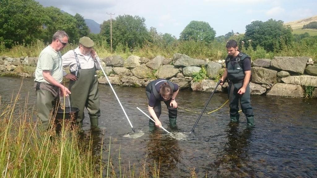
4 1 Introduction 1.1 Background West Cumbria Rivers Trust (WCRT) undertook a second year of catchment characterisation and electrofishing surveys in River Derwent catchment during the summer of This project is the second year of a long term study to obtain scientific data on fish numbers in the River Derwent catchment and yearly surveys will be carried out as part of WCRT s priority activities. This type of fisheries surveys are ideal for providing information to characterise and provide a general indication of the health of stretches of river and will inform where habitat improvement works are required and elicit future funding to carry out necessary measures The River Derwent is designated as a SSSI and SAC with Atlantic Salmon making up one of the key species for this designation. Other species included in this are brook lamprey, river lamprey and otters The Environment Agency (EA) is the statutory body responsible for fish, rivers and the environment in general and their fisheries monitoring programme provides comprehensive coverage of the catchment at a level appropriate to current legislative responsibilities. Monitoring by the EA has however been greatly reduced due to funding cuts and WCRT aims to share all the results, experience and knowledge from this project with them and interested parties. WCRT had also designed its programme to complement, rather than duplicate, the EA s programme and collaboration will take place to deliver many aspects of this work The project has been funded by a variety of sources including the Rivers Corridor Group, Derwent Owners Association, the EA, plus fishing organisations from Cockermouth and Keswick. 1.2 Project Objectives This project aims to determine the state of the Derwent Catchment with science based evidence along with investigating the effectiveness of habitat improvement work that has been completed or is planned for the future. This will be informed by assessing the status and distribution of the juvenile salmonid population, namely salmon (Salmo salar) and Trout (Salmo trutta) fry aged at less than one year The project objectives which were set out in the Project Plan were to undertake the following: Collect, analyse and record data for juvenile salmonid fry populations (and other fish species) to determine their distribution within the Derwent catchment at approximately 130 sites during the summer of 2016 (following the floods of December 2015) Use the data collected to characterise the habitat in the catchment to determine what habitat improvements could be done to encourage greater fish numbers. This will be split into the categories of maintain the current habitat, repair the existing habitat to enhance its future survival and restore the river to having appropriate habitat where this is currently missing. Work in collaboration with the EA to calibrate the different survey methods used in order to ensure wider application of the results and to enable the River Derwent results to be categorised using the National Fisheries Classification Scheme. 4
5 2 Methodology Catchment Characterisation 2.1 Survey Method Licences were applied for and granted by the Fish Movements Team within the EA to carry out surveys and fish rescues within the Derwent Catchment over the summer of Volunteers were recruited from a variety of sources including local fishing clubs, local secondary education institutions, University students and any other interested parties Suitable sites were identified and land custodian consent was asked for permission to access the river and carry out the surveys at each of these sites. A risk assessment of each site was compiled with safe parking and safe river access points noted, along with land custodian contact details for use by the survey team A standard semi-quantitative fish survey method was followed using a back pack electro fishing set. A five minute time period is programmed into the kit which only times when the electric pulse is being used. All fish species captured in the survey were then identified and recorded with the size of salmonid varieties also recorded. Salmonid fry were identified from parr following the method of Scottish Fisheries Co-ordination Centre, (2007) whereby the frequency of each fish length in discrete areas were plotted as histograms and the point where the distribution bell curves intersect is the cut-off point between fry and parr for Salmon and Trout individually In 2016 the WCRT team also worked with the EA to carry out calibration at 26 sites. This involved fully quantitative surveys which are area based to calculate the number of fish per 100m 2, which is the nationally used unit and allows comparison with the data collected by other researchers. To do a fully quantitative survey, a 100m 2 stretch of river is netted off at both ends and the whole area is fished multiple times (usually three) until no fish remain and the total number of fish per 100m 2 is discovered Habitat survey data were collected for each site and included: type of channel substrate (boulders, cobbles, gravel, silt etc.), occurrence of plant life, and large wooded debris (LWD). For each bankside, details of erosion and damage, fencing, vegetation, and adjacent land use were also recorded along with any signs of invasive species. Other details such as potential pollution sources, human activity in the river and signs of terrestrial species such as otter were also recorded. All the habitat survey data were scored, with a weighted scoring system to give an overall habitat condition for each site surveyed. Then additional in house knowledge of each tributaries overall condition and potential for habitat improvements was added to the site score to determine an overall tributary habitat score Data analysis consisted of statistically assigning the recorded fish densities to the national fisheries classification scheme (NFCS) using the calibration results obtained from working with the EA. The results from 2015 were also converted into density per 100m 2 to allow comparison with other areas in the country and also in an attempt to understand the effects of storm Desmond in December (Please note that a direct comparison of sites is not statistically robust as fish densities are extremely variable in space and time, and multiple years worth of data are required to build up a picture of trends in fish density) The NFCS has classifications ranging from A to F as shown in Figure 1. 5

6 Figure 1. NFCS grades from A (the top 20% of fisheries performance in England and Wales) to E (the bottom 20% of fisheries performance in England and Wales), with F as no fish present All of the data collected were plotted using Geographical Information System (GIS) software to provide maps of the distribution of survey results. 2.2 Survey Locations The survey sites were all within the River Derwent Catchment. The majority of tributaries were surveyed, access permitting, usually with multiple sites per tributary. All of the tributaries from the 2015 survey were repeated with additional locations included in the 2016 survey In 2016 a new approach was trailed for main river sites. This involved locating areas of the main Rivers Derwent and Cocker where it was shallow enough to use the backpack in order to estimate the fry distributions there The EA carried out additional surveys on Helvellyn Gill which have also been included in one of the maps in this report. 2.3 Survey timings Surveys were undertaken between August and September 2016 when the salmonid fry were of a reasonable size to capture without damage. 6
7 3 Results 3.1 Summary sites were surveyed by WCRT in the River Derwent Catchment during the summer of 2016 using a semi quantitative method. 26 of these sites were also calibrated with the EA by completing fully quantitative, area based surveys. An additional 10 sites on Helvellyn Gill were surveyed by the EA All fish numbers in 2016 were lower than in the summer of 2015 likely due to the effects of Storm Desmond. Notwithstanding the storm many sites still had salmonids present There were only two sites where no fish of any species were found, one of these is known to have historic mine pollution (Coledale beck) and the other was above a large barrier (Mill Beck). Brokkle Beck which drastically altered course due to the storms in December 2015 and has been allowed to remain in its new course, was already home to a large number of stoneloach (109 per 100m 2 ) and minnow (64 per 100m 2 ) by the summer of In total 1165 salmonids were caught in the summer 2016 surveys, 911 of these were fry with approximately equal numbers of Trout and salmon overall (451 and 461 respectively) sites or 44% of those surveyed had salmon fry present, whilst 92 sites or 67% of those surveyed had Trout present. 3.2 National Fisheries Classification Scheme The calibration of semi quantitative five minute surveys to the EA s fully quantitative area based surveys involved plotting the five minute surveys on a graph against the fully quantitative surveys and using the resulting trend lines to give the following equations which had randomly distributed residuals: Table 1. Calibration trend lines with coefficients of determination which can be used to convert numbers of fish per 5 minute survey to number of fish per 100m 2. Calibration trend line Coefficient of determination (r 2 ) Trout Y = x Salmon Y = x Using the equations in Table 1, the number of fish per 100m 2 could be calculated and therefore the NFCS could be used to classify fry numbers in the River Derwent for both the 2016 results (Table 2 and Figure 3) but also to convert the 2015 results (Table 2 and Figure 2). 7
8 Table 2. Number of sites within the River Derwent catchment in each category of the National Fisheries Classification Scheme for both 2015 and 2016, including ten sites surveyed by the EA. Classification Trout Salmon A B C D E F Total Figure 4 shows only the 2016 results which were in categories A, B and C, or the top 60% of fisheries in England and Wales according to the NFCS. This includes 49 sites for Trout and 19 sites for Salmon. Conversely Figure 5 shows the 2016 results which were in categories D, E and F, or the lower 40% of fisheries in England and Wales Figures 6 to 11 show the NFCS results for both Trout and Salmon broken down by tributary area for more clarity In 2016 the EA were only able to survey 10 sites on Helvellyn Gill in addition to the 25 sites which they calibrated with WCRT due to time constraints. The results for the September survey on Helvellyn Gill are shown in Figure 12 and the number of sites in each category have been added to Table Main river sites Figure 13 shows only the main river sites which was a novel approach for the 2017 surveys. The results show that Trout were not present in high numbers, with 10 of the 13 sites having no Trout fry present. Salmon fry numbers however, were higher, with only 7 of the 13 sites having no Salmon fry present, whilst 7 sites (over half of the main rivers sites surveyed) were in the top 60% of Salmon fisheries in England and Wales according to the NFCS. 8
9 Figure Results converted into NFCS 9
10 Figure NFCS results 10
11 Figure results showing all the scores in the river Derwent which are within the top 60% compared to the rest of England and Wales. Catchment Characterisation 11
12 Figure results showing all the scores in the river Derwent which are within the lowest 40% compared to the rest of England and Wales 12

13 Figure 6. NFCS 2016 Marron Catchment 13

14 Figure 7. NFCS 2016 Cockermouth Tributaries 14

15 Figure 8. NFCS 2016 Lorton Valley 15

16 Figure 9. NFCS 2016 Keswick area 16

17 Figure 10. NFCS 2016 Borrowdale area 17

18 Figure 11. NFCS 2016 Greta tributaries 18

19 Figure 12. NFCS 2016 EA sites on Helvellyn Gill 19

20 Figure 13. NFCS 2016 Main River Sites 20

21 3.4 Habitat characterisation The survey sites were scored using a weighted scoring system, with higher scores meaning better habitat for fish. For example the highest scoring sites had large riparian width, dappled shade, and no stock access, gravel provision with minimal silt, no barriers, no invasive species, and large wooded debris provision These scores where then split into three categories which were defined as requiring the following levels of work to provide the best habitat for fish; Maintain - limited small scale work required such as insertion of large woody debris or tree maintenance (for example, Figure 14) - modest work such as fencing off buffer strips, provision of new gravels, willow spiling and tree planting (for example, Figure 15), Restore - major restoration works such as re-routing the channel required (for example, Figure 16). 3.5 Site Habitat Scores Out of the 138 sites 52 were classed as Maintain, 65 as, and 21 as Restore, (Figure 17) however this only represents the small area observed directly at the survey sites (approximately metres in size). Figure 14. An example of a survey site classified as Maintain, with dappled shade, gravel provision, minimal silt and a fenced riparian strip. 21


22 Figure 15. An example of a survey site classified as, which currently has erosion problems caused by livestock access, but could easily be repaired with fencing and willow spiling or tree planting. Figure 16. An example of a survey site classified as Restore, which has a major siltation problem, invasive species such as Himalayan Balsam present, no shade from trees and minimal riparian fencing for livestock. 3.6 Tributary Habitat Scores The overall tributary habitat scores which incorporated the individual site scores and in house knowledge of each tributary are shown in Figure 18. Out of the 45 tributaries surveyed 9 were classed as Maintain (21%), 32 as (71%), and 4 as Restore (8%). The main rivers were more complicated to categorise, however overall it was considered that the main River Derwent should be classified as. The main River Cocker was split into Maintain at the source, Restore in the middle and further downstream. The notes which helped to decide the tributary habitat score are shown in appendix 1. 22
23 Figure 17. Site habitat score

24 Figure 18. Tributary habitat scores
25 3.7 Invasive non-native species (INNS) As part of the habitat surveys the presence of INNS on each river bank was one of the criteria checked. There were two sightings of Japanese Knotweed, which were treated within a few weeks of the survey and the rest were all the presence of Himalayan Balsam. Figure 19 shows the distribution of INNS within the River Derwent Catchment. 47 out of 138 sites had INNS present on the left river banks and 48 sites had INNS present on the right river bank. Most of the INNS seen were located in the lower catchment. 3.8 Substrate Another criterion in the habitat survey was the percentage of the river substrate made up of boulders, cobbles, gravel, sand and silt. Figure 20 shows the survey sites as the proportion of gravel and silt present in the substrate Gravel is the substrate required for successful salmonid spawning. 95 out of the 138 sites had more than 30% of the substrate made up of gravel, however 10 sites had less than 10% of the substrate made up of gravel. Silt usually prevents successful salmonid reproduction and Figure 20 also shows that 69 out of the 138 sites had no silt present, whilst 13 sites had more than 20% of the total substrate made up of silt. 25
26 Figure 19. Presence of INNS at survey sites 26

27 Figure 20. The percentage of substrate at each survey site made up of gravel (circles) and silt (triangles) 27
28 4 Summary 4.1 Findings from 2016 salmonid numbers Whilst the overall fish numbers were lower in 2016 than the 2015 surveys, most likely as a result of the severe floods in December 2015, a remarkable number of salmonid fry have survived A lot of the sites with low fry numbers in the 2016 surveys, still had parr present, which suggests that the floods in 2015 had greatest effect on redds whilst some fish were able to find shelter from the flood waters This is the second year of surveying juvenile salmonids in the River Derwent catchment so whilst the results cannot yet be used to detect trends, a database is being built using the results Following the calibration of WCRT surveys with those of the EA, the results produced from the River Derwent can be compared to those in the rest of England and Wales which have also used the NFCS. In proceeding years this will enable general trends in salmonid populations to be understood from a country wide perspective rather than just comparisons within the catchment The few main river sites surveyed have generally shown relatively high fry numbers, and have shown that this method is possible, although it is not necessarily representative of the entire main river as the site selection had the constraints of access and deep water Whilst these surveys are primarily to determine juvenile salmonid populations it is important not to ignore other fish species present in the surveys. Other species can be good indicators of potential problems in the river system which salmonids are more sensitive to. For example some sites which had low or no salmonids present had large numbers of Stoneloach, this species is out competed by salmonids but feeds on similar food and requires gravel for spawning in a similar manner to salmonids, however it is more resilient to siltation than Salmon and Trout and so indicates that by reducing silt in these areas salmonids would benefit. 4.2 Findings from 2016 habitat surveys With more sites surveyed in 2016 a greater database of habitat conditions has been built. This database will then be used to inform areas where habitat work would provide the greatest benefit for fish populations. Also considered in the tributary habitat scorings was the feasibility of doing the required habitat work, so that any potentially improvements undertaken have the best chance of being successful It was noted that sites with greater fish densities reflect the sections of river with good habitat and with room for flood waters to spread out across the flood plain and therefore reduce redd washout. In areas where the river has been modified, with built embankments, to flow down an over straight channel, the effects of fast flood flows appears to have reduced the survival of juvenile salmonids In order to test the effectiveness of previous habitat work, and any undertaken as a result of these surveys, it is essential that any habitat work completed is recorded. To be most useful this data would include the exact location with a grid reference, GPS tagged photographs, a description of the work and when it was completed. This would enable the choosing of future survey sites to incorporate known habitat work and to build up a database of the most effective techniques employed and the timescales required for habitat work to be effective. Other sites without habitat improvements would still have to be surveyed in order to provide a contrast to those where work has been completed. 28
29 5 Acknowledgements There are many organisations and individuals who have contributed to make this project, not only work but to become a success. Without all those mentioned below, this project would not be possible and WCRT is extremely grateful to all those who helped in a variety of different ways including; Approximately 100 landowners and tenants who gave permission to access the river from their land, encouraged us to do so and showed great interest in the results. Financial contributions from the Rivers Corridor Group, the Derwent Owners Association, Keswick Anglers, Cockermouth Anglers, and the EA. Advice from other Rivers Trusts, especially Ribble Rivers Trust, the EA and Scotland s Rural College. A lot of very willing and able volunteers who gave up a total of 430 hours of their time to catch fish! 6 References Scottish Fisheries Co-ordination Centre, Electrofishing Team Leader Training Manual. Fisheries Management SVQ Level 3. Manage Electrofishing Operations. Inverness College. 29
30 Appendix 1 Notes about habitat condition for each tributary in the River Derwent system. Tributary Range of habitat scores Broughton Beck Blumer Beck Coal Beck Site habitat categories 3 x Maintain 3 x 2 x Maintain 1 x Restore 2 x Maintain 2 x Tributary habitat category Comments / notes Dash Beck 55 1 x Some fencing potential. Chapel Beck Mill Beck (Chapel Beck) Lair Beck Glenderaterra Whit Beck - Glenderaterra 1 x Maintain 2 x Lots of stoneloach, invertebrates, algae and silt. Some sewage fungus. Lot of flood repair work ongoing. Potential for a lot more fencing projects, some gravel movement. Areas of newly planted trees. A lot of Himalayan Balsam. Channelised in sections and suffered from floods. Litter on river banks, silt in lower reaches. Some fencing done to a high standard but more to do. Very fast flowing, especially where channelised. Minimal invertebrates seen x Maintain Maintain Lots of invertebrates, lots of LWD, some movement in floods Glenderamackin x Maintain 1 x Restore 1 x Maintain 2 x 1 x 1 x Restore 1 x Maintain 3 x Maintain Maintain Maintain Barrow Beck 85 Maintain Lot of algae. Troutbeck x Maintain 2 x 1 x Restore Potential barrier and pollution problems but where fenced has good habitat with LWD. Severe flood damage, bridge washed away, landslip, resulting in dredging. Salmon with a damaged gill. Severe flood damage, lots of invertebrates, potential fencing project in one area. Some flood damage, potential for fencing where banks slumped or where there is livestock poaching. Potential pollution issues, lot of areas of good habitat. Mosedale x Maintain 2 x Maintain Lot of flood damage with gravels washed away and bank repairs already failing. Some fencing but livestock in the buffer strip. St Johns x Maintain 1 x 1 x Restore Potential for more fencing, habitat creation and dappled shade creation. 30
31 Tributary Range of habitat scores Site habitat categories Tributary habitat category Comments / notes Naddle Beck x Maintain 3 x 1 x Restore Flood damage, mainly good habitat, potential for some habitat work and crossings. Some stretches of gravel but with weed in places. Brockle Beck x Some big parr, new river course by lake with a lot of stoneloach already present. Watendlath x Lot of algae, straightened channel in places. Comb Gill x Maintain 1 x No fencing in places, over straightened in places. Stonethwaite 50 Flood damage, very wide channel, potential for dappled shade. Upper Derwent x Maintain 3 x Maintain Flood damage, affected by drought, need for dappled shade and fencing in places. Black Syke x Maintain Maintain Good habitat, mostly fenced although some grazing in buffer strips. Large parr found. Tonge Gill x 2 x Restore Restore Some large constraining embankments with flood damage below, affected by drought, very hot and open in need of dappled shade and fencing Pow Beck x Some livestock poaching but good shade and LWD in places, would benefit from fencing. Newlands Beck x Maintain 2 x Restore 3 x 2 x Restore Some fencing and habitat work required in upper reaches, very large embankments and straightened channels in lower reaches, affected by mine waste. Coledale Beck x 2 x Restore Affected by mine waste, in need of habitat especially shade. Chapel/Comb Beck 56 Restore Weak embankments, heavily grazed. Wythop beck x Maintain 2 x Where fenced has good habitat, good gravel except in lowest reaches. A lot of Himalayan Balsam and silt in lower reaches. Bitter Beck x Maintain 1 x Some litter nearer town, access to main river via culverts. Some potential for fencing. Tom Rudd x Maintain 3 x Potential pollution problems, some cattle poaching, where fenced is good habitat. Whit Beck x Maintain Maintain Two years post restoration. Hope Beck x Maintain 1 x A lot of flood damage, where fenced is good habitat. 31
32 Tributary Range of habitat scores Site habitat categories Tributary habitat category Comments / notes Liza Beck x Maintain 1 x Restore A lot of flood damage, where fenced is good habitat. Gatesgarthdale Beck x 2 x Restore Potential for a lot of habitat creation with shade. Good gravel provision and heterogeneous substrate. Warnscales Beck x Very straight and uniform, but breaking out of channel now it is maintained as wet meadow land. Loweswater x Maintain 2 x 3 x Maintain 2 x Park Beck 80 Maintain Maintain Good substrate, dappled shade and some LWD. Sandy Beck x Maintain 3 x Historically dredged but slowly improving, barrier on road culvert. Where fenced is good habitat. Some flood damage, a lot of Himalayan Balsam. Where not fenced there are a lot of cattle poaching problems. Paddle Beck x Potential pollution problems, very little fencing. A lot of algae, weed and silt in places. River Marron x Maintain 1 x 2 x Restore Black Beck 63 Good habitat and substrate where fenced. Snary Beck 77 Maintain Barrier under road bridges, some litter. Some pollution dealt with by EA. Himalayan Balsam and Japanese Knotweed. Good habitat where fenced and a lot of good substrate. Poaching and silt where no fencing. Wood Beck x Maintain 2 x 1 x Restore Restore Major pollution issue dealt with by EA. Barrier to fish passage from main river. Some steep eroding unfenced banks and a lot of gabions starting to fall into river. Lostrigg Beck x 2 x Restore Good mixed substrate throughout beck but a lot of silt on top. Potential pollution and silt problems throughout beck. Barrier to fish passage near top of catchment. Not much fencing resulting in a lot of livestock poaching. River Cocker x Maintain 2 x 1 x Maintain 1 x 3 x Restore Very channelised with embankments in most places. A lot of gravel with minimal silt. Some poor fencing in places. River Derwent x Maintain 3 x 2 x Restore A lot of flood damage especially to banks. Good habitat where fenced and trees but very poor in areas without. 32
Know Your River River Afan Salmon and Sea Trout Catchment Summary
 Know Your River River Afan Salmon and Sea Trout Catchment Summary Introduction This report describes the status of the salmon and sea trout populations in the Afan catchments. Bringing together data from
Know Your River River Neath Salmon and Sea Trout Catchment Summary
 Know Your River River Neath Salmon and Sea Trout Catchment Summary Introduction This report describes the status of the salmon and sea trout populations in the Neath catchments. Bringing together data
Know Your River - River Ogmore Salmon and Sea Trout Catchment Summary
 Know Your River - River Ogmore Salmon and Sea Trout Catchment Summary Introduction This report describes the status of the salmon and sea trout populations in the Ogmore catchments. Bringing together data
Know Your River River Loughor Salmon and Sea Trout Catchment Summary
 Know Your River River Loughor Salmon and Sea Trout Catchment Summary Introduction This report describes the status of the salmon and sea trout populations in the Loughor catchments. Bringing together data
Know Your River Dee Salmon & Sea Trout Catchment Summary
 Know Your River Dee Salmon & Sea Trout Catchment Summary Introduction This report describes the status of the salmon and sea trout populations in the Dee catchment. Bringing together data from rod catches,
Know Your River - Ogwen Salmon & Sea Trout Catchment Summary
 Know Your River - Ogwen Salmon & Sea Trout Catchment Summary Introduction This report describes the status of the salmon and sea trout populations in the Ogwen catchment. Bringing together data from rod
Know Your River Conwy Salmon & Sea Trout Catchment Summary
 Know Your River Conwy Salmon & Sea Trout Catchment Summary Introduction This report describes the status of the salmon and sea trout populations in the Conwy catchment. Bringing together data from rod
Fish population survey report
 Fish population survey report Upper River Avon Catchment This report provides a summary of results from recent fish population surveys on the Tetbury Avon, Sherston Avon and River Marden The surveys were
Know Your River - Clwyd Salmon & Sea Trout Catchment Summary
 Know Your River - Clwyd Salmon & Sea Trout Catchment Summary Introduction This report describes the status of the salmon and sea trout populations in the Clwyd catchment. Bringing together data from rod
The Spey Catchment Initiative
 The Spey Catchment Initiative Introducing the Spey Catchment Initiative The Spey Catchment Initiative is a new project which aims to help deliver the objectives of the River Spey Catchment Management Plan
Know Your River Conwy Salmon & Sea Trout Catchment Summary
 Know Your River Conwy Salmon & Sea Trout Catchment Summary Introduction This report describes the status of the salmon and sea trout populations in the Conwy catchment. Bringing together data from rod
Know Your River - Clwyd Salmon & Sea Trout Catchment Summary
 Know Your River - Clwyd Salmon & Sea Trout Catchment Summary Introduction This report describes the status of the salmon and sea trout populations in the Clwyd catchment. Bringing together data from rod
ELECTRO-FISHING REPORT 2016 UPPER TWEED
 ELECTRO-FISHING REPORT 2016 UPPER TWEED The electro-fishing programme carried out each summer by The Tweed Foundation is part of our management plan, which details the information that is required to manage
Pearls in Peril (PIP): Securing the future of the freshwater pearl mussel in Great Britain. Layman s Report LIFE project LIFE/NAT/000383: PIP GB
: Securing the future of the freshwater pearl mussel in Great Britain. Layman s Report LIFE project LIFE/NAT/000383: PIP GB") Pearls in Peril (PIP): Securing the future of the freshwater pearl mussel in Great Britain Layman s Report LIFE project LIFE/NAT/000383: PIP GB Where we worked Our aims Restore in-stream habitats for freshwater
Pearls in Peril (PIP): Securing the future of the freshwater pearl mussel in Great Britain Layman s Report LIFE project LIFE/NAT/000383: PIP GB Where we worked Our aims Restore in-stream habitats for freshwater
Cornwell brook Cornwell Manor
 Cornwell brook Cornwell Manor An Advisory Visit by the Wild Trout Trust February 2014 1 1. Introduction This report is the output of a Wild Trout Trust visit to a tributary of the Cornwell Brook at Cornwell
Salmon Five Point Approach restoring salmon in England
 Salmon Five Point Approach restoring salmon in England Our Mission To restore the abundance, diversity and resilience of salmon stocks throughout England We will do this by:- a) Maximising the production
THE RIVER ALUN (aka ALYN)
") THE RIVER ALUN (aka ALYN) Advisory Visit Report Undertaken On behalf of the Wild Trout Trust By Ron Holloway MIFM 22 nd April 2002-04-25 The River Alun The Rossett & Gresford Fly Fishing Club R H Associates
THE RIVER ALUN (aka ALYN) Advisory Visit Report Undertaken On behalf of the Wild Trout Trust By Ron Holloway MIFM 22 nd April 2002-04-25 The River Alun The Rossett & Gresford Fly Fishing Club R H Associates
Fish Survey Report and Stocking Advice for Loch Milton. (Loch a Mhuilinn), May 2011
, May 2011") Fish Survey Report and Stocking Advice for Loch Milton (Loch a Mhuilinn), May 2011 Jonah Tosney Freshwater Fisheries Biologist Wester Ross Fisheries Trust 1 Loch Milton (Loch a Mhuilinn) Fish Survey Report
Fish Survey Report and Stocking Advice for Loch Milton (Loch a Mhuilinn), May 2011 Jonah Tosney Freshwater Fisheries Biologist Wester Ross Fisheries Trust 1 Loch Milton (Loch a Mhuilinn) Fish Survey Report
Floating Pennywort Project. River Medway and River Cray locations
 Floating Pennywort Project River Medway and River Cray locations 2011 Andrea Griffiths (BSc) Partnership Officer Medway Valley Countryside Partnership MVCP Floating Pennywort Report 2011 Andrea Griffiths
Minnesota Department of Natural Resources Division of Fish and Wildlife Section of Fisheries. Stream Survey Report. Luxemburg Creek.
 Minnesota F-29-R(P)-24 Area 315 Study 3 March 2016 Minnesota Department of Natural Resources Division of Fish and Wildlife Section of Fisheries Stream Survey Report Luxemburg Creek 2015 Mark Pelham Sauk
Don Pedro Project Relicensing
 Don Pedro Project Relicensing M ODESTO I RRIGATION D ISTRICT TURLOCK I RRIGATION D ISTRICT FERC PROJECT N O. 2299 Resident Fish in Don Pedro Reservoir Don Pedro Reservoir Fish Stocking (1971-Present) CDFG
River Medway Upper Medway Fly Fishers
 River Medway Upper Medway Fly Fishers An Advisory Visit by the Wild Trout Trust April 2015 1 1. Introduction This report is the output of a site meeting and walk-over survey of a 2-km stretch of the River
Trust Projects Cromarty Firth Fishery Trust Report. Wild Fishery Reform. New hatchery and facilities. Education Programme
 Cromarty Firth Fishery Trust Report Wild Fishery Reform In February 2017 the Scottish Government announced a scaling down of the Wild Fishery Reform process. The proposed merger of Fishery Boards and Trusts,
TAY DISTRICT SALMON FISHERIES BOARD POLICY ON SALMON STOCKING
 TAY DISTRICT SALMON FISHERIES BOARD POLICY ON SALMON STOCKING August 2011 1 INTRODUCTION This document describes the policy adopted by the Tay District Salmon Fisheries Board for the artificial stocking
STEELHEAD SURVEYS IN OMAK CREEK
 STEELHEAD SURVEYS IN OMAK CREEK 2002 Annual Report Prepared by Chris Fisher John Arterburn Colville Confederated Tribes Fish and Wildlife Department P.O. Box 150 Nespelem, WA 99155 Prepared for Project
HABITAT ADVISORY VISIT TO THE RIVER CERNE, DORSET. UNDERTAKEN BY VAUGHAN LEWIS, WINDRUSH AEC LTD ON BEHALF OF THE GALLIA FAMILY
 HABITAT ADVISORY VISIT TO THE RIVER CERNE, DORSET. UNDERTAKEN BY VAUGHAN LEWIS, WINDRUSH AEC LTD ON BEHALF OF THE GALLIA FAMILY APRIL 2008 1.0 Introduction This report is the output of a site visit undertaken
Advisory Visit 25 th September Rivers Greta & Derwent, Cumbria. On Behalf of Keswick & District Angling Association
 Advisory Visit 25 th September 2007 Rivers Greta & Derwent, Cumbria On Behalf of Keswick & District Angling Association 1.0 Introduction (Advisory Visit) This report is the output of a site visit undertaken
Yours Aye Eddie. Chairman of the LLFT
 Welcome to the Loch Lomond Fisheries Trust (LLFT) second Annual Newsletter. Most of you will know the role of the Trust: we are an environmental charity which exists to champion the conservation of Loch
Advisory Visit. River Irthing, Cumbria. 7 th July, 2010
 Advisory Visit River Irthing, Cumbria 7 th July, 2010 1.0 Introduction This report is the output of a site visit undertaken by Tim Jacklin of the Wild Trout Trust to the River Irthing, Cumbria on 7 th
Steelhead Society of BC. Thompson River Watershed Restoration and Enhancement Project #4 Nicola River Bank Stabilization and Enhancement Project
 Steelhead Society of BC Presents: Thompson River Watershed Restoration and Enhancement Project #4 Nicola River Bank Stabilization and Enhancement Project Application for Funding December 2013 1.0 BACKGROUND
2013 Electrofishing Program Summary. Miramichi Salmon Association In collaboration with the Department of Fisheries and Oceans
 2013 Electrofishing Program Summary Miramichi Salmon Association In collaboration with the Department of Fisheries and Oceans Prepared by: Alex Parker Biologist Miramichi Salmon Association 485, Route
Big Spring Creek Habitat Enhancement and Fishery Management Plans
 Big Spring Creek Habitat Enhancement and Fishery Management Plans November 5, 2012 Big Spring Events and Activities Center Newville, PA Charlie McGarrell Regional Habitat Biologist Pennsylvania Fish and
White-clawed crayfish (Austropotamobius pallipes)
") Contents Objectives... 1 Introduction... 1 National Status... 2 Local Status... 2 Local Examples... 2 Legal Status... 3 Links to other Local Action Plans... 3 Threats... 3 Requirements... 4 Local Action...
Contents Objectives... 1 Introduction... 1 National Status... 2 Local Status... 2 Local Examples... 2 Legal Status... 3 Links to other Local Action Plans... 3 Threats... 3 Requirements... 4 Local Action...
Loughs Agency Gníomhaireacht na Lochanna Factrie fur Loughs
 CONSULTATION DOCUMENT PROPOSED AMENDMENTS OF THE FOYLE AREA (CONTROL OF FISHING) REGULATIONS 1999 Foyle Area (Control of Fishing) (Amendment) Regulations 2008 INTRODUCTION This Consultation Document sets
Advisory Visit. Bradshaw Brook, Lancashire. August 2010
 Advisory Visit Bradshaw Brook, Lancashire August 2010 1.0 Introduction This report is the output of a site visit undertaken by Tim Jacklin of the Wild Trout Trust to the Bradshaw Brook, Bolton, Lancashire
Fisheries Management Scotland
 Fisheries Management Scotland Our role and priorities Dr Alan Wells Fisheries Management Scotland Established in November 2016. ASFB constitution altered to change the name to Fisheries Management Scotland,
HABITAT ADVISORY VISIT TO THE RIVER ITCHEN, CHERITON BISHOP, HAMPSHIRE.
 HABITAT ADVISORY VISIT TO THE RIVER ITCHEN, CHERITON BISHOP, HAMPSHIRE. UNDERTAKEN BY VAUGHAN LEWIS, WINDRUSH AEC LTD ON BEHALF OF SUSSEX PISCATORIAL SOCIETY DECEMBER 2005 Sponsored by: 1.0 Introduction
Fish Stock Survey - Monitoring Report. Action E3
 Fish Stock Survey - Monitoring Report Action E3 LIFE09 NAT/IE/000220 BLACKWATER SAMOK 2014 The IRD Duhallow LIFE Project is supported through the LIFE financial instrument of the European Community. Contents
IFM SCOTLAND S CODE of GOOD PRACTICE for FRESHWATER FISHERIES MANAGEMENT part 1: Salmon & Trout
 IFM SCOTLAND S CODE of GOOD PRACTICE for FRESHWATER FISHERIES MANAGEMENT part 1: Salmon & Trout Guides to freshwater fisheries management have been one of the pillars of the British publishing industry
COA-F17-F-1343 YEAR END REPORT
 DAVE MARSHALL SALMON RESERVE RESTORATION, MAINTENANCE, AND UPGRADES YEAR END REPORT Prepared for: Fish and Wildlife Compensation Program Prepared by: Edith Tobe, RPBio, Executive Director Box 1791, Squamish,
Salmon spawning report 2010
 Salmon spawning report 21 Midlands Region, West Julie Cowley, April 211 We are the Environment Agency. It's our job to look after your environment and make it a better place - for you, and for future generations.
FINAL REPORT. Yonkers Creek Migration Barrier Removal Project Wonderstump Road Del Norte County. Submitted By:
 FINAL REPORT Yonkers Creek Migration Barrier Removal Project Wonderstump Road Del Norte County Submitted By: Del Norte County Community Development Department Yonkers Creek Migration Barrier Removal Project
South Cumbria Rivers Trust Electrofishing Report
 South Cumbria Rivers Trust Electrofishing - 2016 Report A project funded by CaBA & Natural Course 2 Contractor This document was produced by the South Cumbria Rivers Trust Jayne Wilkinson: Catchment Planning
Abundance of Steelhead and Coho Salmon in the Lagunitas Creek Drainage, Marin County, California
 scanned for KRIS Abundance of Steelhead and Coho Salmon in the Lagunitas Creek Drainage, Marin County, California Prepared for: Marin Municipal Water District 220 Nellen Drive Corte Madera, California
Old Stream is a highly productive cold water tributary to the Machias River located in Washington County, Maine. The Machias River contains a portion
 www.maine.gov/dmr Old Stream is a highly productive cold water tributary to the Machias River located in Washington County, Maine. The Machias River contains a portion of the Gulf of Maine Distinct Population
S U R V E Y R E P O R T
 S U R V E Y R E P O R T Isle of Mull Rivers Project: Summary of 2010 Fish Populations, Habitat Surveys and Potential Habitat Management Initiatives This report should be quoted as: Argyll Fisheries Trust
Holderness. The Three Watersheds within the Newfound Lake Drainage Dorchester. Groton Plymouth. Ashland. Hebron. Canaan. Bridgewater.
 Background Brook trout are the only native stream dwelling trout species in New Hampshire, having a historic range that extended from Georgia to eastern Canada. It is believed that wild brook trout were
Draft report on one day visit to Brampton Bryan, R. Teme
 Dr Nick Giles & Associates, 50 Lake Road, Verwood, Dorset, BH31 6BX. Telephone 01202 824245 Fax 01202 828056 email nickgiles@cix.co.uk Consultants : Freshwater Fisheries, Conservation & Wetland Ecology
The Salmonid Species. The Salmonid Species. Definitions of Salmonid Clans. The Salmonid Species
 The Salmonid Species The Salmonid Species N. American salmon (2 more Asian species) Chinook ( King ) Coho ( Silver ) Sockeye Chum ( Dog ) Pink ( Humpy ) Sea-run trout Steelhead, Cutthroat, Dolly Varden
Discussion on the Selection of the Recommended Fish Passage Design Discharge
 Discussion on the Selection of the Recommended Fish Passage Design Discharge Introduction The provision of fish passage is a requirement for most proposed culvert and bridge installations in Alberta, depending
NORTH WEST WATER AUTHORITY RIVERS DIVISION SCIENTISTS DEPARTMENT TECHNICAL SUPPORT GROUP
 NORTH WEST WATER AUTHORITY RIVERS DIVISION SCIENTISTS DEPARTMENT TECHNICAL SUPPORT GROUP ELECTROFISHING SURVEY OF THE RIVER AND ITS TRIBUTARIES APRIL 1978 CALDER B. Williams N.W.W.A. RIVERS DIVISION SCIENTISTS
Rehabilitation of Grimes Creek, a Stream Impacted in the Past by Bucket-lined Dredge Gold Mining, Boise River Drainage, July 2008 to August 2011.
 Rehabilitation of Grimes Creek, a Stream Impacted in the Past by Bucket-lined Dredge Gold Mining, Boise River Drainage, July 2008 to August 2011. Pam Harrington TU,1020 W. Main Street Suite 440, Boise,
RIVER CONONISH INVERTEBRATE SURVEY Dr Kjersti Birkeland
 RIVER CONONISH INVERTEBRATE SURVEY 26 Dr Kjersti Birkeland Background The Cononish, the upper reaches of the River Dochart, should be very important for spring salmon but surveys by the Tay District Salmon
Loughs Agency Water Framework Directive Fish in Rivers Classification Report 2014 Water Framework Directive Fish Population Assessment
 LOUGHS AGENCY OF THE FOYLE CARLINGFORD AND IRISH LIGHTS COMMISSION Loughs Agency Water Framework Directive Fish in Rivers Classification Report 214 Water Framework Directive Fish Population Assessment
Loughs Agency Freshwater Fisheries Monitoring Programme
 Loughs Agency Freshwater Fisheries Monitoring Programme Fisheries Coordination Centre/RAFTS Annual Biologists Meeting 29 th 30 th January 2014 Marine Scotland Freshwater Laboratory, Pitlochry Art Niven,
Fish population survey report
 Fish population survey report River Teme 2016 This report provides a summary of results from recent coarse fish population surveys on the River Teme between Tenbury Wells and Powick. The surveys were carried
14 OTTER SPECIES ACTION PLAN
 14 OTTER SPECIES ACTION PLAN 14.1 INTRODUCTION As a 'top predator' the Otter Lutra lutra is naturally scarce and also highly sensitive to the health of the whole ecosystem that supports it. As such, the
FISHERY MANAGEMENT ISSUES - LUNAN WATER
 ERFT Putting the fish in efficiency FISHERY MANAGEMENT ISSUES - LUNAN WATER A DESIGNATED SALMON RIVER UNDER NASCO OBJECTIVES OF THE TRUST: To advance environmental protection and improvement by conserving
Assessing Ecosystem Impacts from Road Stream Crossings through Community Involvement
 Assessing Ecosystem Impacts from Road Stream Crossings through Community Involvement Background Why is the NH Fish and Game Department interested in culverts? Block fish migration Reduce opportunities
5B. Management of invasive species in the Cosumnes and Mokelumne River Basins
 5B. Management of invasive species in the Cosumnes and Mokelumne River Basins Cosumnes River The Cosumnes River basin has a number of distinct habitat types that require different management strategies
MCCAW REACH RESTORATION
 Final Report MCCAW REACH FISH RESTORATION PHASE B Jack McCaw Inland Empire Action Coalition http://www.wwccd.net/ Phone: 509-956-3777 Hours: 8:00-4:30 Walla Walla County Conservation District Snake River
NASCO Guidelines for the Protection, Restoration and Enhancement of Atlantic Salmon Habitat
 NASCO Guidelines for the Protection, Restoration and Enhancement of Atlantic Salmon Habitat 1 NASCO Guidelines for the Protection, Restoration and Enhancement of Atlantic Salmon Habitat Additional copies
3. The qualification raised by the ISRP is addressed in #2 above and in the work area submittal and review by the ISRP as addressed in #1.
 Please find attached a response from The Confederated Tribes of the Warm Springs Reservation of Oregon (CTWSRO) for Project # 2008-301-00, Habitat Restoration Planning, Design and Implementation within
REPORT OF PHASE 1 OF AN EASTERN TAY DISTRICT RIPARIAN SURVEY. David Summers and Robert Mitchell Tay Foundation May 2010
 REPORT OF PHASE 1 OF AN EASTERN TAY DISTRICT RIPARIAN SURVEY 1. INTRODUCTON David Summers and Robert Mitchell Tay Foundation May 2010 The eastern half of the Tay district mainly consists of arable farmland
Guidance Note. Hydropower Guidance Note: HGN 8 Fish Passage. When do you need to install a fish pass?
 Guidance Note Hydropower Guidance Note: This guidance note is not intended as a statement of law. It should be read in combination with, and in the context of, the relevant enactments and EU obligations.
Fish population survey report
 Fish population survey report River Lugg This report provides a summary of results from recent fish population surveys on the River Lugg between Leominster and Hereford. The surveys were carried out to
River Darent Darent Valley Trout Fishers
 River Darent Darent Valley Trout Fishers An advisory visit carried out by the Wild Trout Trust April 2010 1. Introduction This report is the output of a Wild Trout Trust advisory visit undertaken on the
Little Kern Golden Trout Status:
 Little Kern Golden Trout Status: The Little Kern Golden trout (LKGT) was proposed for federal listing as Threatened under the Endangered Species Act (ESA) on September 1, 1977 by the U. S. Fish and Wildlife
Habitat Advisory visit to the River Fergus system Co.Clare, Eire. Undertaken on behalf of Ennis and District Anglers Association, by Vaughan Lewis,
 Habitat Advisory visit to the River Fergus system Co.Clare, Eire. Undertaken on behalf of Ennis and District Anglers Association, by Vaughan Lewis, Windrush AEC Ltd April 2006 1.0 Introduction This report
Fish Community. Fish Habitat, Streams and Rivers
 Clear, Ston(e)y and White Lake Plan Fish Community The lakes support a cool/warm water fishery including muskellunge, walleye, largemouth and smallmouth bass, yellow perch, pumpkinseed, rockbass, blue
Mid-Columbia Fisheries Enhancement Group Annual Report Fiscal Year 06: July 1, 2005 June 30, 2006
 Mid-Columbia Fisheries Enhancement Group Annual Report Fiscal Year 06: July 1, 2005 June 30, 2006 Mission Statement The mission of the Mid-Columbia Fisheries Enhancement Group is to restore self-sustaining
River Semington West Lavington
 River Semington West Lavington An advisory visit carried out by the Wild Trout Trust December 2009 1. Introduction This report is the output of a Wild Trout Trust advisory visit undertaken on the headwaters
Michigan Department of Natural Resources Status of the Fishery Resource Report Page 1
 Michigan Department of Natural Resources 2008-59 Status of the Fishery Resource Report Page 1 Bowens Manistee County, (T24N R16W Sec. 11, 12, 13, 14, 15, 24, and 30). Last surveyed 2008 Mark A. Tonello
Current Status and Management Recommendations for the Fishery in the Cloverleaf Chain of Lakes
 Current Status and Management Recommendations for the Fishery in the Cloverleaf Chain of Lakes Jason Breeggemann Senior Fisheries Biologist Wisconsin Department of Natural Resources Outline DNR fisheries
FISH PASSAGE IMPROVEMENT in California s Watersheds. Assessments & Recommendations by the Fish Passage Forum
 FISH PASSAGE IMPROVEMENT in California s Watersheds Assessments & Recommendations by the Fish Passage Forum FISH PASSAGE IMPROVEMENT in California s Watersheds The mission of the Fish Passage Forum is
SUMMARY OF MOVEMENT AND HABITAT USED BY TAGGED BROOK TROUT IN THE MAIN BRANCH AND NORTH BRANCH AU SABLE RIVER DURING SUMMER Data Submitted to:
 SUMMARY OF MOVEMENT AND HABITAT USED BY TAGGED BROOK TROUT IN THE MAIN BRANCH AND NORTH BRANCH AU SABLE RIVER DURING SUMMER 2014 Data Submitted to: Anglers of the Au Sable Submitted by: Dr. Mark R. Luttenton
Eastern Brook Trout. Roadmap to
 Eastern Brook Trout Roadmap to CONSERVATION Our Brook Trout heritage he wild Brook Trout is an American symbol of persistence, adaptability, and the pristine wilderness that covered North America prior
Green crabs: invaders in the Great Marsh Featured scientist: Alyssa Novak from the Center for Coastal Studies/Boston University
 Name Green crabs: invaders in the Great Marsh Featured scientist: Alyssa Novak from the Center for Coastal Studies/Boston University Research Background: Marshes are areas along the coast that flood with
Nechako white sturgeon are an Endangered Species
 Nechako white sturgeon are an Endangered Species There are likely less than 350 Nechako white sturgeon, and historically there were over 5000 in the Nechako Watershed. Endangered as per the Species at
Conservation Limits and Management Targets
 Conservation Limits and Management Targets Setting conservation limits The use of conservation limits (CLs) in England and Wales (E&W) has developed in line with the requirement of ICES and NASCO to set
Burns Paiute Tribe Fisheries Department. Evaluate The Life History Of Native Salmonids Within The Malheur Subbasin Project #
 Burns Paiute Tribe Fisheries Department Evaluate The Life History Of Native Salmonids Within The Malheur Subbasin Project # 199701900 Prior to 1990 Technical and/or scientific background Malheur population,
The Cromarty Firth Fishery Trust Education Programme.
 The Cromarty Firth Fishery Trust Education Programme. Mayfly in the classroom. Mayfly in the classroom projects have been underway within the Cromarty Firth Catchment for the last four years, visiting
Council CNL(16)30. Annual Progress Report on Actions Taken Under the Implementation Plan for the Calendar Year EU - Spain (Navarra)
30. Annual Progress Report on Actions Taken Under the Implementation Plan for the Calendar Year EU - Spain (Navarra)") Agenda item 6.1 For information Council CNL(16)30 Annual Progress Report on Actions Taken Under the Implementation Plan for the Calendar Year 2015 EU - Spain (Navarra) CNL(16)30 Annual Progress Report
Agenda item 6.1 For information Council CNL(16)30 Annual Progress Report on Actions Taken Under the Implementation Plan for the Calendar Year 2015 EU - Spain (Navarra) CNL(16)30 Annual Progress Report
Klamath Lake Bull Trout
 Klamath Lake Bull Trout Existing Populations The Klamath Lake Bull Trout SMU is comprised of seven existing populations and four populations classified as extinct or functionally extinct (Table 189). Populations
River Afan Afan Valley Angling Club
 River Afan Afan Valley Angling Club An advisory visit carried out by the Wild Trout Trust February 2010 1. Introduction This report is the output of a Wild Trout Trust advisory visit undertaken on the
FISHERIES BLUE MOUNTAINS ADAPTATION PARTNERSHIP
 FISHERIES A warming climate, by itself, substantially affects the hydrology of watersheds in the Blue Mountains. Among the key hydrologic changes projected under all scenarios for the 2040s and beyond
Chagrin River TMDL Appendices. Appendix F
 Appendix F The following are excerpts from the Eastern Brook Trout Joint Venture s Conservation Strategy (Working Draft v.6), Conserving the Eastern Brook Trout: Strategies for Action Found at: http://www.easternbrooktrout.org/constrategy.html
STREAM CLASSIFICATION AND MAPPING. Prepared For. MacMillan Bloedel Ltd. Menzies Bay Division BOX 6000, Campbell River V9W 5E1.
 STREAM CLASSIFICATION AND MAPPING OF STREAMS IN MENZIES AND OYSTER BAY Prepared For MacMillan Bloedel Ltd. Menzies Bay Division BOX 6000, Campbell River V9W 5E1 September 1998 a a North Island Biological
Angling Trust East of England Fisheries Forum (Cambridge)
") Angling Trust East of England Fisheries Forum (Cambridge) Chris Middleton & Kye Jerrom Fisheries, Biodiversity & Geomorphology East Anglia Area 17 November 2016 This presentation is a snap shot of where
Angling Trust East of England Fisheries Forum (Cambridge) Chris Middleton & Kye Jerrom Fisheries, Biodiversity & Geomorphology East Anglia Area 17 November 2016 This presentation is a snap shot of where
How Capel Brook An advisory visit carried out by the Wild Trout Trust July 2010
 How Capel Brook An advisory visit carried out by the Wild Trout Trust July 2010 1. Introduction This report is the output of a Wild Trout Trust advisory visit undertaken on the How Capel Brook, one of
Throughout the report, normal convention is followed, with right bank (RB) and left bank (LB) of the river identified when looking downstream.
 and left bank (LB) of the river identified when looking downstream.") Habitat Advisory visit to the River Robe, Co. Mayo, Eire. Undertaken on behalf of the River Robe Angling Club by Vaughan Lewis, Windrush AEC Ltd May 2013 1.0 Introduction This report forms the output of
Habitat Advisory visit to the River Robe, Co. Mayo, Eire. Undertaken on behalf of the River Robe Angling Club by Vaughan Lewis, Windrush AEC Ltd May 2013 1.0 Introduction This report forms the output of
D. Clifton-Dey M. Walsingham January 1995.
 REPORT ON THE ANALYSIS OF SALMON SCALE SAMPLES RETURNED BY AMGLERS ON THE RIVERS RJBBLE AND HODDER. NRA/NW/FTR/95/ D. CliftonDey M. Walsingham January 995. CONTENTS Page Summary Introduction 2 Methods
Current projects for Fisheries Research Unit of Minnesota Department of Natural Resources
 Current projects for Fisheries Research Unit of Minnesota Department of Natural Resources MAJOR RESOURCE ISSUES IN THE DIVISION OF FISHERIES Status of Fish Populations To effectively manage fish populations,
Rampart Stream Fish Stock Survey - Monitoring Report
 Rampart Stream Fish Stock Survey - Monitoring Report Action E3 LIFE09 NAT/IE/000220 BLACKWATER SAMOK 2015 The IRD Duhallow LIFE Project is supported through the LIFE financial instrument of the European
The Wild Trout Trust. Giving Wild Trout A Future!
 Giving Wild Trout A Future! Talk today: Quick introduction to the WTT and its work Case Study WTT habitat work and river flies Our Mission We are a charity dedicated to: The conservation of wild trout
The Fishery. Newfoundland Region Stock Status Report D2-05
 Fisheries Pêches and Oceans et Océans DFO Science Newfoundland Region Stock Status Report D2-05 ATLANTIC SALMON INSULAR NEWFOUNDLAND, SOUTHWEST COAST, SALMON FISHING AREAS 12-13 Background Salmon Fishing
River Leach Cotswold Fly Fishers
 River Leach Cotswold Fly Fishers A Project Proposal by the Wild Trout Trust - April 2015 1 1. Introduction This report is the output of a site visit to the River Leach on water controlled by the Cotswold
Proposed Marine Park in the Brothers Islands
 Proposed Marine Park in the Brothers Islands PURPOSE This paper presents the preliminary plan of the proposed marine park in the Brothers Islands (BIMP) for protection and enhancement of Chinese White
Warner Lakes Redband Trout
 Warner Lakes Redband Trout Existing Populations Warner Valley is an endorheic basin that contains a complex series of interconnected lakes, marshes, sloughs, and potholes, all of which are remnants of
Ecological Appraisal Monitoring ecosystems; identifying pollution causes & impacts
 Ecological Appraisal Monitoring ecosystems; identifying pollution causes & impacts Major issues over the last 3 months: Arctic Charr monitoring in Llyn Padarn Seine netting in North Wales estuaries Llyn