January 2012 (Revised July 2012) US Army Corps of Engineers Savannah District South Atlantic Division
|
|
|
- Laurence Lewis
- 5 years ago
- Views:
Transcription
 US Army Corps of Engineers Savannah District South Atlantic")
1 ENVIRONMENTAL IMPACT STATEMENT APPENDIX B: Biological Assessment of Threatened and Endangered Species SAVANNAH HARBOR EXPANSION PROJECT Chatham County, Georgia and Jasper County, South Carolina January 2012 (Revised July 2012) US Army Corps of Engineers Savannah District South Atlantic Division
2 This page intentionally blank
3 Biological Assessment of Threatened and Endangered Species TABLE OF CONTENTS ITEM Page No PROJECT DESCRIPTION Existing -42 Foot Depth Alternatives Foot Alternative Foot Alternative Foot Alternative Foot Alternative Foot Alternative Selected Plan AFFECTED ENVIRONMENT PRIOR COORDINATION SPECIES CONSIDERED UNDER THIS ASSESSMENT Updated lists of Federally Threatened and Endangered (T&E) species for the project area Updated lists of Georgia s Known Occurrences of Conservation Areas and Special Concern Animals and Plants on or Near Savannah Harbor Navigation Project, Chatham County, Georgia Updated lists of South Carolina s Rare, Threatened, and Endangered Species of Jasper County and Adjacent Counties DREDGING METHODS Hydraulic Dredges Pipeline Dredges Cutterhead Suction Dredge Hopper Dredge Mechanical Dredges Bed Levelers Impacts of Hydraulic Dredges and Mechanical Dredges General Impacts Pipeline Dredges Cutterhead Suction Dredge, Hopper Dredge and Mechanical Dredge PROPOSED CONDITIONS...44 i
4 ITEM TABLE OF CONTENTS Page No IMPACTS TO GEORGIA AND SOUTH CAROLINA PROTECTED SPECIES AND SPECIES OF CONCERN ANIMALS AND PLANTS AND NATURAL COMMUNITIES Primary and Secondary Impacts Species Listed for Chatham County, Georgia Spotted Turtle American Oystercatcher Black-necked Stilt Black-crowned Night Heron False Killer Whale Black Skimmer Least Tern Seaside Sparrow Wilson s Plover Eastern Diamond backed Rattlesnake Bald Eagle Migrant Loggerhead Shrike Northern Yellow Bat Robust Redhorse Yellow Crowned Night Heron Painted Bunting Gopher Frog Many Lined Salamander Eastern Mudminnow Narrowleaf Obedient Plan Swamp Hibiscus Wild Yellow Cowpea Conservation Areas, Chatham County, Georgia Species Listed for Jasper County, South Carolina Bachman s Sparrow Barrel Floater Spotted Turtle Bluebarred pygmy sunfish Carolina slabshell Striped mud turtle Pygmy sperm whale Yellow lampmussel Dwarf siren Gulf coast mud salamander Eastern floater...62 ii
5 TABLE OF CONTENTS ITEM Page No Black swamp snake Least tern Paper pondshell Eastern creekshell Coastal Plain water hyssop Cayaponia Buckwheat tree Creeping St. John s Wort Leafy pineweed Grassland arrowhead Florida yellow-eyed grass Acid swamp yellow-eyed grass Slender leaved Dragon Head Hairy Fever Tree Conservation Areas, Jasper County, South Carolina IMPACTS TO FEDERALLY LISTED THREATENED AND ENDANGERED SPECIES General Impacts Species Accounts Red-cockaded woodpecker, American chaffseed, Pondberry, Canby s dropwort, Kirtland s Warbler, Bachman s warbler, Eastern indigo snake, and Flatwoods salamander Wood stork Piping plover West Indian Manatee North Atlantic Right Whale, Finback Whale, Humpback Whale, Sei Whale, Blue Whale, and Sperm Whale Sea Turtles Atlantic Sturgeon and Shortnose Sturgeon SUMMARY EFFECT DETERMINATION LITERATURE CITED Addendum Responses to US Fish and Wildlife Service Comments iii
6 ITEM TABLES Page No. Table 1-1 Summary of Container Vessel Calls (One Way) Arriving at Garden City Terminal...1 Table 1-2 Present Advanced Maintenance Sections...7 Table 1-3 Existing Turning Basins in Savannah Harbor...8 Table 1-4 Existing CDFs in Savannah Harbor...8 Table 1-5 Proposed Two New Meeting Areas...20 Table 1-6 New Channel Bend Wideners...20 Table 1-7 Length of Bar Channel Extension Required for Depth Alternatives...20 Table 4-1 Federally Threatened and Endangered Species Potentially Present in Chatham County, Georgia and Jasper County, South Carolina...24 Table 4-2 Georgia s Known Occurrences of Conservation Areas and Special Concern Animals and Plants On or Near Savannah Harbor Navigation Project, Chatham County, Georgia...26 Table 4-3 South Carolina s Rare, Threatened, and Endangered Species of Jasper County...29 Table 8-1 Order of Contact of Corps Personnel for Dredging Contractor to Report Manatee Death or Injury...80 Table 8-2 Comparison of Sediment Disposal Activities for Alternate Alignments of the Proposed Bar Channel Extension Table 8-3 Hopper Dredges Expected to Dredge New Work and Maintenance Sediments Table 8-4 Number of Loggerhead Sea Turtle Nests in Georgia for Table 8-5 Sea Turtle Nest Totals; Tybee Island, GA Table 8-6 Loggerhead Sea Turtle Nest Totals for Daufuskie and Turtle Islands Table 8-7 Total Incidental Sea Turtle Takes by Species for SAD from Table 8-8 Mean Water Temperature, Salinity, and Dissolved Oxygen (D.O.) by Table 8-9 Season at Locations where Adult Shortnose sturgeon were Found Mean Water Temperature, Salinity, and D.O. by Season at Locations where Juvenile Shortnose sturgeon were Found Table 8-10 Summary of Shortnose sturgeon Habitat Suitability Criteria in the Savannah River Estuary Table 8-11 Known Shortnose Sturgeon Population Densities Table 8-12 Historic and Current Spawning Populations of Atlantic sturgeon in East Coast Estuarine Systems of the United States Table 8-13 Summary of Project-Related Impacts Without Mitigation Table 8-14 Summary of Project-Related Impacts With Mitigation Table 8-15 Benthic Substrate Frequency in Augusta Shoals Study Area Table 8-16 Comparison of Fish Passage Alternatives iv
7 ITEM FIGURES Page No. Figure 1-1 Overview Map of Savannah Harbor...4 Figure 1-2 Approved Unconfined Placement Sites for Maintenance Material Figure 1-3 Location of Savannah Harbor Placement Sites as authorized by 1996 LTMS...11 Figure 1-4 Project Vicinity Map...18 Figure 5-1 Cutterhead Pipeline Dredge Schematic...35 Figure 5-2 Hopper Dredge Schematic...36 Figure 5-3 Photograph Taken from Manson Construction Company, Hopper Dredge Bayport...37 Figure 5-4 Hopper Dredge in Operation and Figure of Draghead with Turtle Deflector...38 Figure 5-5 Mechanical Dredge (Clamshell Bucket and Barge)...40 Figure 8-1 Piping plover Critical Habitat...76 Figure 8-2 Proposed Southeastern US Area Mandatory Speed Restrictions (calving and nursery grounds)...95 Figure 8-3 Proposed Mid-Atlantic US area Mandatory Speed Restrictions (migratory route)...96 Figure 8-4 The Three aerial Early Warning System Zones...97 Figure 8-5 Northern Right Whale Critical Habitat Areas Defined for the Southeastern United States Figure 8-6 The Selected New Channel Alignment Figure 8-7 Location of Bar Channel Alignment and Pilot Boarding Areas Figure 8-8 Right Whale Sightings per Unit Effort (SPUE) Figure Right Whale Calving Season Data Figure Right Whale Calving Season Data Figure 8-11 Right Whale Sightings through March Figure 8-12 Plotted Frequency of Right Whale Sighting Events Figure 8-13 Example Design Drawings of Rigid Adjustable Turtle Deflector Figure 8-14 Photographs of Hopper Dredge Inflow and Overflow Screening Figure 8-15 Example Graphic Generated by DQM Figure 8-16 Map Depicting the Five Distinct Population Segments (DPSs) of Atlantic sturgeon Figure 8-17 Total Sturgeon Incidental Takes Documented from for Hopper, Pipeline, Clamshell Dredging Techniques Figure 8-18 Distribution of Sturgeon Incidental Take by Dredge Type and Channel Location since 1990 throughout the South Atlantic Division Figure 8-19 Conceptual Side Channel Fish Passage Design v
8 This page intentionally blank
9 BIOLOGICAL ASSESSMENT OF THREATENED AND ENDANGERED SPECIES FOR THE SAVANNAH HARBOR EXPANSION PROJECT CHATHAM COUNTY, GEORGIA AND JASPER COUNTY, SOUTH CAROLINA UNDER THE ENDANGERED SPECIES ACT OF 1973, AS AMENDED 1.00 PROJECT DESCRIPTION 1.1 EXISTING -42 FOOT DEPTH (EXISTING CONDITION or NO ACTION ALTERNATIVE). The No Action alternative serves as the baseline from which potential project impacts are measured. This plan is also the Without Project Condition; those actions which would occur even if the alternative proposed in this EIS is not implemented. The Plan consists of continued operation and maintenance of the Savannah Harbor Navigation Project at the existing -42 Foot Depth. This includes annual dredging to maintain authorized depths in the channel and associated areas. Federal use would continue for the existing confined disposal areas, the EPA-approved ocean disposal site (Savannah Harbor ODMDS), and Site 2 and Site 3 located adjacent to the entrance channel. As approved in the LTMS, suitable maintenance material could also be placed in the nearshore feeder berm sites off Tybee Island or directly on Tybee Island Beach. Cargoes would continue to move through the harbor. The volumes and types of those cargoes would depend on both the demand for those goods and options for ways in which those demands can be met (sources of supply, transportation methodologies and routes, etc.). Previous investigations indicate that demand for goods moving through Savannah Harbor, particularly as containerized cargos, will increase in the future. In addition, due to ongoing ship-building trends, the size of the vessels calling at ports along the US east coast is expected to increase. These trends are described in detail in the Economics Appendix of the GRR. Table 1-1 below illustrates the fleet expected to call on the Port of Savannah if the proposed harbor deepening does not occur compared to the fleet that would call at the various depth alternatives. Table 1-1. Summary of Container Vessel Calls (One Way) Arriving at Garden City Terminal 2016 Post-Panamax Gen II Post-Panamax Gen I Panamax Sub-Panamax Total -42 feet Baseline , , feet , , feet , , feet , , feet , , feet , ,141 1
10 2020 Post-Panamax Gen II Table 1-1. Continued Post-Panamax Gen I Panamax Sub-Panamax Total -42 feet Baseline , feet , feet , feet , feet , feet , Post-Panamax Gen II Post-Panamax Gen I Panamax Sub-Panamax Total -42 feet Baseline 382 1,006 1, , feet , feet , feet , feet , feet , Post-Panamax Gen II Post-Panamax Gen I Panamax Sub-Panamax Total -42 feet Baseline 527 1,421 1, , feet 1, , , feet 1, , , feet 1, , feet 1, , feet 1, , Post-Panamax Gen II Post-Panamax Gen I Panamax Sub-Panamax Total -42 feet Baseline 527 1,421 1, , feet 1, , , feet 1, , , feet 1, , feet 1, , feet 1, ,601 2
11 1.01 EXISTING -42 DEPTH The existing Savannah Harbor Federal Navigation Project can be described as follows (see paragraphs a through k, below): a. General Description. Savannah Harbor is a deep-draft harbor on the South Atlantic coast 75 statute miles south of Charleston Harbor and 120 miles north of Jacksonville Harbor, Florida. Within the inner harbor limits, the Savannah River is generally divided into two channels by a series of islands. From the Atlantic Ocean (Station 0+000) to Station (River Mile 10), where the river converges, the harbor is separated into South and North Channels. Within this area, the navigation channel is maintained in North Channel. After divergence of the river into Front and Back Rivers at Station (River Mile 11), the navigation channel is maintained in Front River and passes by the business district of the City of Savannah. The navigation channel is maintained in Front River to the upper limits of the harbor at Station (River Mile 21.3). Figure 1-1 shows the station numbering convention that is used in the harbor. The ocean ward extent of the ocean bar channel presently ends at Station B (or 60,000 feet east or ocean ward of the river entrance at Fort Pulaski and B stands for Ocean Bar Channel). The entrance to the river is at Station (or near the Fort Pulaski National Monument in Georgia). Upstream of the river entrance is Fort Jackson and the CSS Georgia at Stations to (or 55,000 to 60,000 feet upstream of the Fort Pulaski National Monument). The upstream end of the proposed deepening of the harbor at the Garden City Terminal is at Station (or 103,000 feet upstream of the river entrance). A separate navigation project the Savannah River below Augusta Project extends from the upper limits of the harbor to River Mile at Augusta, Georgia. The authorized channel is 9- feet deep and 90-feet wide, although it has not been maintained since The Atlantic Intracoastal Waterway (AIWW) crosses the deep-draft navigation channel at approximately Station (River Mile 5). The authorized depth of that channel is 12-feet deep, while the width varies from 90-feet in land cuts to 150-feet in open waters. b. Inner Harbor (Stations to 0+000). The authorized navigation channel in the inner harbor is 42-feet deep Mean Low Water and 500-feet wide upstream of Station to Station From Station (River Mile 19.5) to the upstream end of the Argyle Island Turning Basin Station (River Mile 19.9), the channel is 36-feet deep and 400-feet wide upstream. From Station (River Mile 19.9) to the harbor s upstream limit at Station (River Mile 21.3), the channel is 30-feet deep and 200-feet wide. 3

12 Figure 1-1. Overview map of Savannah Harbor. 4
13 The Federal channel was last modified in 2006 through two small realignments in the upper portion of the harbor (USACE 2006). These actions consisted of a realignment of the Federal navigation channel along Ranges 37 and 38 (here on referred to as the CB-8 realignment) and a separate realignment along Ranges 41, 42, and 43 (here on referred to as the Upper Harbor realignment). The CB-8 realignment consisted of a 1,652-foot realignment in the area of Ranges 37 and 38 across from the Georgia Ports Authority (GPA) Container Berth 8 (CB-8). The 1,652- foot segment of the channel was moved roughly 53 feet to the north. The realignment occurred in an area that was dredged in 2005 during construction of the GPA CB-8, therefore; no new dredging was required. The Upper Harbor realignment consisted of a 100-foot realignment in the area of Ranges 41 through 43, which create a bend in the Savannah River upper harbor near Port Wentworth (downstream of Station ). That action increased the width in the bend along the northern edge of the existing channel. Width changes on the three ranges making up the bend vary from 50 to150 feet. The centerline and the southern edge of the channel did not change. The proposed widening is located in an area with natural depths at or below the authorized project depth, so no new dredging was required. Sections of eroding shoreline along the CDFs located in South Carolina have been protected through several actions since The most recent of these was rock protection work that occurred along portions of CDFs 13A, 13B, 14A and 14B from 2006 to Environmental approvals for this work were obtained through prior agency approvals of the Long Term Management Strategy (LTMS). The work included bank protection along 4,400 feet of eroding riverbank in five non-continuous areas between Stations and The river shoreline along the Jones/Oysterbed Island CDF will be protected with rock starting in FY12, with completion scheduled for FY 13. The commercially-owned, Southern Liquefied Natural Gas-El Paso (SLNG-El Paso) Terminal, on Elba Island, near Station expanded its facility when it completed construction of a fourth storage tank in This expansion included construction of a berthing slip to accommodate larger Liquefied Natural Gas (LNG) carriers. SLNG-El Paso recently constructed a fifth storage tank to further expand the Elba Island Facility and expects to place that tank in service in These facility expansions are expected to result in increases in the number of LNG vessels calling at the SLNG-El Paso Terminal. The Economics Appendix in the GRR provides more detailed information on the expected extent of that growth. c. Outer Harbor or Ocean Bar Channel (Stations to B). Station is located at the mouth of the harbor near the Fort Pulaski National Monument in Georgia. The entrance channel is located north of Tybee Island and proceeds out to deep water in the ocean. The existing navigation channel is 44 feet deep and 600 feet wide from deep water in the ocean (mile 11.17B or Station B) to the channel between the jetties (mile 2.6B or Station B), thence 42 feet deep and 500 feet wide to the harbor entrance (River Mile 0.0 Station 0+000). The existing project includes allowable overdepth and advance maintenance dredging (see Section e and Table 3-1, below). 5
14 d. Annual Maintenance Dredging. Approximately 7 million cubic yards of sediments are removed each year from the Savannah Harbor Navigation Project. The dredged sediments are placed in areas which have been designated for use for the project: the CDFs, Site 2 and Site 3 adjacent to the Ocean Bar Channel, and/or the Savannah Harbor ODMDS. As approved in the LTMS, suitable maintenance material could also be placed in the nearshore feeder berm sites off Tybee Island or directly on Tybee Island Beach. e. Allowable Overdepth and Advance Maintenance Dredging. The following information is provided pursuant to Guidance Memorandum dated January 17, 2006 and ER : Congress specifically authorizes Federal navigation channels by specific depth and width. There is inherent imprecision in dredging processes which vary with the physical conditions (tides, currents, and waves); the dredged material characteristics (silt, clay, sand, gravel, rock, etc.); the channel design (depths being dredged, side slopes, etc.); and the type of dredging equipment (mechanical, hydraulic, hopper, etc.). Due to these variables and the resulting imprecision associated with the dredging activity, Corps engineering design, cost estimating and construction contracting documents recognize that dredging below the Congressionally authorized project dimensions will occur and is necessary to assure the required depth and width as well as cost effective operability. To balance project construction requirements against the need to limit dredging and disposal to the minimum required to achieve the designed dimensions, a paid or allowable overdepth (including side slopes) is incorporated into the project-dredging prism. Material removed from this allowable overdepth is paid under the terms of the dredging contract. Material removed beyond the limits of the allowable overdepth is not paid. Dredging contracts for the Savannah Harbor include a - 2 foot allowable overdepth. To ensure the contractor obtains the required dredging template, the Corps pays the contractor for up to 2- feet of sediment that he may remove below that required depth. Depending on the type of dredging equipment used, an additional depth of sediments may be disturbed in the dredging process but not removed. This depth is greater with the larger cutterhead dredges. The rotating cutterhead that loosens the deposited sediments extends below the elevation of the suction pipe. The suction is not sufficient to lift sediments up into the pipe for removal through the pipe to the dredge, but only enough to remove sediments which have been loosened and slurried by the rotating cutterhead. This results in sediments below the elevation of the suction pipe being disturbed by the rotating cutterhead, but not removed through the dredge pipe line. The disturbance can result in the mixing of sediments above and below the removal depth. For the large 30-inch cutterhead dredges, this disturbance depth can be 3 feet. Equipment such as hopper dredges or clamshell dredges would have a disturbance depth of less than 1 foot. Advance maintenance extends the length of time during which authorized channel depths are available. This reduces the frequency of dredging, thereby increasing dredging efficiency, reducing disturbance to the environment, and reducing overall maintenance costs. This sediment management technique is performed by enlarging the channel cross-section to provide storage for deposited sediments outside the authorized navigation channel prism. This storage is typically below the elevation of the navigation channel, but can be on the side of a channel if sediment deposition patterns reveal that such a design would be effective. This technique 6
15 increases dredging efficiency by concentrating the sediments to be removed. This lowers the unit cost of dredging, reducing overall maintenance costs. Under present Corps policy, a District office must request approval for all advance maintenance from higher Corps offices. Decisions to implement advance maintenance can be made at any time upon review of sediment accumulation records, and they are effective until future information indicates they are no longer necessary or cost effective. Compliance with all environmental, engineering, and economic criteria is required prior to implementation of authorized advance maintenance features. The currently authorized advance maintenance is found in Table 1-2, below. Begin Station Table 1-2. Present Advance Maintenance Sections End Station Authorized Advanced Maintenance (feet) Required Contract Depth (feet MLLW) Inner Harbor Port Wentworth TB Argyle Island TB Kings Island TB Marsh Island TB Fig Island TB Entrance Channel (B) (B) (B) No advance maintenance is presently performed between Stations and to reduce potential impacts to the CSS GEORGIA, which is located along that reach. f. Turning Basins. Six authorized turning basins are located along the navigation channel to allow ships to be turned before transiting the harbor. There is also a private turning basin at Elba Island between the Jones/Oysterbed and Fig Island turning basins. This basin is used by the LNG vessels calling at Elba Island. The turning basins are described in Table 1-3, below. 7
16 Table 1-3. Existing Turning Basins in Savannah Harbor (see Figure 1-1) Name Length (Feet) Width (Feet) Depth (Feet, MLLW) River mile Station Port Wentworth to Argyle Island to Kings Island 1,600 1, to Marsh Island 900 1, to Fig Island 1,500 1, to Elba Island (LNG Private) Oysterbed Island Rehandling Basin 2,300 1, Not Maintained , to , to g. Existing upland Confined Disposal Facilities (CDFs). The Georgia DOT (non-federal sponsor) has provided seven confined upland disposal facilities for use in the Savannah Harbor. Those areas are shown in Table 1-4. Area Number Table 1-4. Existing CDFs in Savannah Harbor Area Name Location (Channel Stations) Size (Acres) --- Jones/Oysterbed to B to A to B to A to 6+500BR 1,307 12A BR to BR 1,123 2A Argyle-Hutchinson to N Onslow-North to NOTES: "BR" indicates the Stationing up Back River as shown on the Annual Survey. Historic Area 12B was combined with 13A in The enlarged cell is now referred to as 13A. 8
17 h. Overall Management Strategy for CDFs. Savannah District is working with the Georgia Department of Transportation, the Project's non-federal sponsor, to maximize the useful life of the dredged material placement areas. As an overall strategy, beneficial uses are pursued for the dredged sediment to reduce the ultimate storage volume required and increase secondary benefits resulting from the storage and/or disposal operations. To reduce the required storage volume, sediments deposited in the CDFs are used when fill material is needed to raise the height of the confining dikes. Disposal Area 1N is not regularly used. The site is within the Savannah National Wildlife Refuge, and the Refuge managers have requested the Corps only deposit sands at that site so they can be readily reused and removed. Disposal Area 1S is no longer used because it is not diked. Disposal Area 2A is limited to about 125,000 cubic yards of maintenance material every three years and will be closed in Underdrains have been installed in Disposal Areas 12A, 13A, and 13B to shorten the sediment drying time. This aids the sediment consolidation process, thereby extending the useful life of the sites. A rotational program is being followed at Disposal Areas 12A, 13A, 13B, 14A, 14B, and Jones/Oysterbed Island to provide flooded acreage for wildlife habitat while the site is active and allow sufficient time for drying of the sediment so that construction equipment can safely work on the floor of the CDFs to remove sediments for dike raising. The District uses a suspended solids content standard of 500 mg/l for acceptability of its weir effluents. This ensures the discharges do not cause unacceptable impacts to aquatic life in the receiving waters. Selective placement of Bar Channel and other suitable sediments may be pursued when beneficial uses would be derived. As a component of the design process for maintenance dredging work, a review would be conducted of potential beneficial uses -- specifically alternative placement sites -- for sediments to be excavated during that contract. The placement location to be used for a specific dredging contract would be decided during project design and the award would be based on identification of the least cost, environmentally-acceptable option. If placement at a certain location is found to be more desirable for environmental or other reasons but would be more costly than one of the other acceptable options, it can be pursued with appropriate cost sharing using Section 933 (WRDA 1986) or Section 204 (WRDA 1992) authorities. i. Unconfined Placement Sites. The USEPA-designated Savannah Ocean Dredged Material Disposal Site (ODMDS) is the primary unconfined placement site used in the harbor. Additional authorized unconfined placement sites are a feeder berm system within the nearshore area off Tybee Island, and two sites adjacent to the ocean bar channel (see Figure 1-2). The ODMDS was designated by EPA for sediment placement under Section 103 of the Marine Protection, Research and Sanctuaries Act of 1972 (MPRSA), as amended (40 CFR Parts 220 to 228). The nearshore feeder berm sites off Tybee island and adjacent to the entrance channel were authorized through the Savannah Harbor Navigation Project s Long Term Management Strategy (LTMS) study under Section 404 of the Clean Water Act. As shown in Figure 1-3 below, there were five submerged berm sites (Sites 2-6) adjacent to the entrance channel that could be used for the placement of maintenance material. However, the USEPA recently indicated that any dredged material placement sites located outside of the three-mile limit should be designated as ocean disposal sites under the MPRSA. Consequently, any future use of the sites along the entrance channel outside the three-mile line would require that they be designated as ocean dredged material disposal sites. Exceptions to this requirement are Site 2 and Site 3 which are within the 3-mile limit. Site 2 and Site 3 would continue to be available for the placement of maintenance material from the entrance channel. 9

18 Although these dredged material placement sites have not been used in the past, the LTMS also authorized placement of maintenance material into nearshore feeder berm sites off Tybee Island as well as direct placement on the beach at Tybee Island. More discussion of these sites is provided in subsequent paragraphs. In 1987, EPA completed formal designation and approval of an offshore site (Savannah ODMDS) located 3.7 nautical miles east of the coastline and about 0.25 nautical miles (1,500 feet) south of the navigation channel as a dredged material disposal site. The site's center is located at 31 56'54"N and 80 45'34"W (Figure 1-2). The designated site was the one which Figure 1-2. Approved Unconfined Placement Sites for Maintenance Material. Savannah District had been using for many years for placement of sediments removed from the Bar Channel. Sediments are typically excavated from the Bar Channel by hopper dredges and then transported to the Savannah ODMDS for disposal. This procedure was previously evaluated in 1991 for new work sediments and determined to meet the criteria established to implement Section 103 of the Marine Protection, Research and Sanctuaries Act of 1972 (MPRSA), as amended (40 CFR Parts 220 to 228). This EIS contains an update of that evaluation in Appendix R, SECTION 103 Ocean Disposal Evaluation. More details on the historic use of the site can be found in that portion of this document. The site s designation as a sediment placement site extends until the site is full. 10
19 The LTMS (USACE 1996) authorized the placement of dredged maintenance sediment in feeder berm sites in the nearshore area off Tybee Island and adjacent to the entrance channel. The nearshore area is the shallow area immediately oceanward of the ocean shoreline. As shown in Figure 1-3, maintenance sediments dredged from the Bar Channel were authorized to be deposited in sites (Sites 2-6) adjacent to that channel to construct and maintain underwater berms in that nearshore environment. Figure 1-3. Location of Savannah Harbor Placement Sites (Site 2 through Site 6) as authorized by 1996 LTMS. The sites where these submerged berms would have been constructed would effectively serve as nearshore placement sites for use by hydraulic dredges maintaining the Bar Channel. Presently, that portion of the project is dredged by hopper dredges, but the four-month window during which the sea turtle restrictions allow hopper dredges to be used severely limits the ability of the District to respond to rapidly forming or shifting shoals in that channel. There are no seasonal restrictions on hydraulic dredges since that equipment does not adversely affect sea turtles. Sites 2-6 provided a cost-effective place for the hydraulic dredges to deposit the dredged sediments since they would be located relatively close to the channel. Some of the sites adjacent to the channel are too shallow for use by hopper dredges. Using a mooring barge and the pumpout 11
20 capability of some hopper dredges would make such placement technically feasible, but would probably increase the placement costs to unacceptable levels. Sites 2-6 are located south of and at least 2,000 feet away from the channel, in water averaging about 15 feet deep. Deposition on the berms would occur when their size has been significantly reduced, but in no case would it be performed on a yearly basis. When constructed, the berms would be either round or elliptical and oriented away from the channel so that tidal currents which converge and diverge from the channel are not significantly restricted. The minimum 2,000 foot spacing between the toes of adjacent berm sites is a design feature to ensure that tidal currents are not significantly restricted. The crest of the berm would not exceed about -5 feet MLLW to ensure recreational boats could pass over the berms unaffected. No hard structures are used in the formation or maintenance of the berms so that nothing would snag shrimp nets which may be dragged over the berms. If sediments are transported to the site through use of a hydraulic pipeline dredge, the discharge point would be below the water surface to reduce turbidity. The sites are located at least 4,000 feet offshore, so turbidity increases at the beach would not be significant. Site 5 was used in FY06, FY08, and FY10 and has received about 523,000 cubic yards of dredged material. Site 6 was used in FY08, FY09, and FY10 and has received about 1,021,000 cubic yards of material. As discussed previously, only Site 2 and Site 3 are available for future use at this time. Site 3, Site 4, Site 5, and Site 6 are beyond the 3-mile line and would require site designation studies and additional approval by EPA for use as approved ocean dredged material disposal sites. The 1996 LTMS also authorized the placement of suitable maintenance sediments into the nearshore area off Tybee Island as well as directly on the beach. The initial plan for placement of maintenance material into the nearshore area off Tybee Island involved the construction of a submerged feeder berm. The proposed feeder berm would have been constructed parallel to Tybee beach, about 4,000 to 7,000 feet offshore, in water with an average depth of about 8 feet MLLW. The berm's crest would have been up to 500 feet wide and at a depth of 5 feet MLLW. Restricting the berm height to -5 feet MLLW would ensure that pleasure boats could safely pass over the berm. The berm would have been located at least 5,000 feet away from the channel. It was determined that approximately 66,000 CY of fill material would be needed per 1,000 linear feet of berm. Assuming side slopes of 1(H) to 30(V) and a 50 percent loss of material volume during placement, 132,000 CY of channel dredging would have been placed per 1,000 linear feet of berm. The shallow depth of the area in which the feeder berm would be constructed would result in the berm being dispersive, with the deposited sediments subsequently being moved offsite by waves. The relatively close proximity of the berm to the beach would increase the likelihood that the sediments would migrate to the beach. As waves expend energy moving material from the berms, the waves will have less energy to erode the Tybee Island shoreline. This would increase the stability of that barrier island. No hard structures would be used in the formation or maintenance of the feeder berm so that nothing would snag shrimp nets which may be dragged over it. As with the submerged berms, 12
21 the feeder berm would effectively serve as a nearshore placement area for use by hydraulic dredges working in the Bar Channel. Sediments would be transported and deposited at the site through use of a hydraulic pipeline. The discharge point would be below the water surface to reduce turbidity. The sites would be located at least 4,000 feet offshore, so turbidity increases at the beach would not be significant. After completion of the 1996 LTMS study, further studies were conducted to refine the plan for placing maintenance sediments into the nearshore area off Tybee. This included model studies conducted by ERDC (2003). During SHEP studies, it became apparent that placement of new work material from construction of the project into the nearshore area off Tybee Island might also be advantageous. Rather than placing the new work dredged sediment from the Entrance Channel into the offshore Savannah Harbor ODMDS, the Corps proposed to place dredged sediment back into the nearshore zone of Tybee Island as a beneficial use to restore sand to the nearshore sand sharing system (USACE 2007). These sediment placement mounds would dampen wave action and provide protection from storm events, and increase bird and fish habitat. Savannah District followed an iterative process to develop a plan for placement of sediments from the entrance channel. The work started with an engineering determination of the quantity of sediments to be removed at various channel depths and the percent fines / percent sands of those sediments. The Corps reviewed previous information, including the Draft 2003 ERDC Report on Nearshore Placement at Tybee Island; the previously environmentally-approved placement areas on the south side of the entrance channel; and the changes to the GA CZM Program that incorporates Georgia HB 727. The Corps started by developing a placement plan with a priority placed on low cost. The plan was also reviewed from an environmental perspective. The Corps consulted GA DNR-CRD, who provided several alternate placement scenarios. The plan was also discussed with the coastal engineering consultant to Tybee Island to obtain his engineering views and learn, in general terms, what he would advise Tybee Island concerning the various issues and proposals. The Corps revised the plan to incorporate the views of GA DNR-CRD and Tybee s consultant. During that period, cost engineers were also consulted to learn what would be reasonable from a cost perspective (keep pumping distances under the length where booster pumps would be needed), and what placement designs would not cause adverse currents or result in rapid migration of deposited sediments toward the shipping channel. Using that information, a revised sediment placement plan was developed. The plan was coordinated with staff of GA DNR-CRD and CRD and Tybee s coastal engineering consultant. The Corps revised the plan again based on the results of this coordination. The revised plan included the following assumptions: a. A 30-inch pipeline dredge can pump material a total distance of about 3 miles without a booster pump. The design would be based on there not being a need for a booster pump. 13
22 b. Hopper dredges (with pump ashore capability) may not be effective since the nearshore water depths off Tybee Island are less than 15 feet mean high water. A loaded hopper dredge generally needs about 25 feet of water under its keel. c. For each Entrance Channel reach from Stations to , the dredge quantities in cubic yards for the greatest dredging depth (i.e., -47 foot depth) was used for all disposal sites. As a result of the extensive coordination with GA DNR-CRD and the City of Tybee Island, the Corps proposed in the DEIS to place new work and maintenance sediments in the nearshore area off Tybee Island which would provide beneficial use of dredged material and comply with the Georgia Coastal Management Program, including the changes that incorporate Georgia HB 727. The proposed dredged material placement plan also included two sites (Site 11 and Site 12) which would have been constructed from material from the entrance channel extension to provide additional fish habitat in the area. The sediment placement sites identified in this plan are shown in Figure 1-3 and described below: a. MLW 200 has a total capacity of 217,000 cubic yards and is located west of the North Groin on Tybee Island. The sediment would be deposited at the mean low water (MLW) line and be allowed to mound up to mean sea level (MSL) or mid-tide. When filled to capacity, the placement would create a mid-tide berm about 200 feet wide and 3,200 feet long. b. MLW 500 has a total capacity of 1.8 MCY and is located south of the North Groin on Tybee Island. The sediment would be deposited at the MLW line and be allowed to mound up to MSL or mid-tide. When filled to capacity, the placement would create a mid-tide berm about 500 feet wide and 11,000 feet long. c. ERDC Nearshore has a total capacity of 1.2 MCY and is located below the mean low water contour (MLW) in the nearshore area off Tybee Island. At total capacity, the top elevation of the placement site would be -4 feet so as not to interfere with boaters but allow potential for movement of material towards the Tybee Island shoreline by wave action. d. Site 2 has a total capacity of 3.2 MCY and is located below the mean low water contour (MLW) in the nearshore area off Tybee Island. At total capacity, the top elevation of the placement site would be at mean high water (Elevation +8 feet MLW). Site 2 would also provide bird and fish habitats. e. Site 2 Extension has a total capacity of 4.3 MCY and is located below the mean low water contour (MLW) in the nearshore area off Tybee Island. At total capacity, the top elevation of the placement site would extend to -4 feet MLW. f. Sites 2, 3, 4, 5 and 6 are located south of the entrance channel and between Site 2 and the ODMDS. These four sites were authorized through the LTMS (USACE 1996). g. Savannah Harbor Ocean Dredged Material Disposal Site (ODMDS). The USEPAapproved ODMDS is a 4.26 square mile (or 2,726.4 acres) site and is centered at 31 56' 54" N 14
23 and 80 45' 34" W. Total capacity is about 56,8 MCY and at capacity the top elevation would be -26 feet MLW. h. Site 11 has a total capacity of 2.1 MCY and is located south of the proposed channel extension. At total capacity, the top elevation of the placement site would extend to -10 feet MLW. This mound would provide fish habitat. i. Site 12 has a total capacity of 3.0 MCYand is located south of the proposed channel extension. At total capacity, the top elevation of the placement site would extend to -10 feet MLW. This mound would provide fish habitat. This site would provide habitat by establishing a variation in contours of the water bottoms. Based on comments received after coordination of the DEIS, the placement plan described above has been revised. Both the City of Tybee Island and the GADNR-CRD expressed concern over the quality (fines content) of the new work material proposed to be placed in the nearshore area, and they requested that the nearshore feeder berms off Tybee not be constructed. The GADNR also expressed concerns about adverse effects to recreational and commercial fishing associated with the use of Sites 11 and 12. Also, the EPA commented that Sites 4, 5, 6, 11, and 12 were beyond the 3-mile line and would require site designation studies and their site designation approval as dredged material ocean disposal sites before they could be used. Consequently, all new work material removed from the entrance channel would be placed in either a CDF or the ODMDS. From a maintenance perspective, placing inner harbor maintenance sediments into the seven upland CDFs and entrance channel maintenance sediments into the Savannah Harbor ODMDS or Site 2 and Site 3 is the least-cost environmentally acceptable disposal alternative (Base Plan) for long-term maintenance of the proposed harbor deepening project. However, suitable maintenance sediments from both the inner harbor and entrance channel of the deepened project could be used for beach renourishment or placed into the nearshore feeder berms authorized in the LTMS. A non-federal sponsor would be required to pay the expected additional costs to deposit the O&M sediments in areas that are not included in the Base Plan. Figure 1-2 shows the approved dredged material placement sites for maintenance material from the entrance channel as well as suitable material from the first portion of the inner harbor channel. Before sediment is initially placed in a nearshore site, Savannah District would perform confirmatory surveys to ensure that no hard-bottom communities and/or cultural resources are located at the proposed construction sites. If any hard-bottom areas are located, no maintenance sediments will be placed within these areas. Should any cultural resources be identified, the Georgia SHPO would be consulted. Deposition of dredged sediment on any unknown submerged cultural resource would not adversely affect it, but would instead provide additional protection from wave- or current-induced exposure and erosion. The LTMS (USACE 1996) also authorized a nearshore bird island (Tomkins Island) that was subsequently constructed approximately 10,000 feet offshore of Turtle Island, about 3,000 feet north of the north jetty in South Carolina waters that averaged 6 feet of depth. The island is horseshoe in shape with flat crown at +14 feet MLLW with a minimum size of 2 acres. The side 15
24 slopes from EL 14 to 8 are roughly 1:10, with the slopes below +8 feet MLLW being 1:35. The island provides a very productive habitat setting for colonial nesting birds and regularly provides one of the most successful nesting sites in South Carolina for several shorebird species. j. Sediment Control Works. The Sediment Control Works were authorized separately, but are features of the Savannah Harbor Navigation Project. Authorized sediment control works in the harbor consist of the Tidegate structure across Back River and a Sediment Basin immediately downstream of the Tidegate. These structures were designed to concentrate sedimentation outside the navigation channel in a location close to confined disposal facilities. Both the concentration of sediment and the short pumping distance reduced the cost of sediment removal in the harbor. The Sediment Basin was authorized at a 40-foot depth, 600-foot width and approximately 2-mile length, with an entrance channel 38 feet deep and 300 feet wide. The Tidegate became operative in May 1977, but was taken out of service due to adverse environmental impacts in October A drainage canal, known as New Cut, located across Argyle Island was constructed along with the Tidegate. New Cut was closed in 1990 to reduce salinity levels in the Savannah National Wildlife Refuge, restore approximately 4,000 acres of freshwater marsh, and reduce the flushing of striped bass eggs and larvae into the Front River. k. Freshwater Control Works. The Sediment Control Works also include a Freshwater Control System. During the development of the harbor deepening and sediment control features in the 1970 s, it was recognized that the saltwater wedge would move farther upstream as a result of these projects. This would have produced unacceptable salinity levels at the Savannah National Wildlife Refuge s (SNWR) freshwater intake on Little Back River and adverse impacts on freshwater marshes in the Savannah National Wildlife Refuge (NWR) and adjacent private lands. To offset these impacts, a freshwater supply system was included in the project. This system had the following five components: (1) 5,500-foot long canal through McCoombs Cut to provide freshwater to the Savannah NWR (Figure 4). The canal was constructed with a 200-foot bottom width at EL -7' MLLW and 2H:1V side slopes. The design flow through McCoombs Cut was 4,000 CFS. (2) a channel in Middle River with a 90-foot bottom width at EL -6' MLLW and 2H:1V side slopes. The design flow in Middle River was 1,500 CFS. (3) a channel in Little Back River with a 200-foot bottom width at EL -5.1' MLLW and 2H:1V side slopes. The design flow in Little Back River was 2,500 CFS. (4) 28,000-foot long freshwater supply canal with a 28-foot bottom width at EL -4' MLLW, 2H:1V side slopes, and water control structures. (5) 3,700-foot long connecting canal with a 6-foot bottom width at EL -4' MLLW, 2H:1V side slopes. Congress also authorized a freshwater canal extending from the Savannah NWR to private lands located north of the US Highway 17A Bridge on the South Carolina side of the river. That canal was designed with a 6-foot bottom width at EL -4' MLLW and 2H:1V side slopes. 16
25 The Federal government is responsible for maintenance of the Diversion Canal, the channels in Little Back River and Middle River, and the canals and control works for the Refuge. Although annual maintenance has been performed on this system, the maintenance costs have exceeded what was originally envisioned. The salinity levels corrode equipment, requiring more rapid replacement. The non-federal project sponsor, the Georgia Department of Transportation, is responsible for the canal serving private lands southeast of the Refuge. In 1982, the non-federal sponsor entered into a supplemental agreement with the private property owners, transferring responsibility for normal dike maintenance for facilities on the private lands to those property owners. The sponsor has delivered sand to the area for the property owners' use in dike maintenance. Recently, the Corps performed the first major rehabilitation of the water control features of the system. The Corps began rehabilitation of water control structures located on the SNWR in May 2010 to restore them to their original operating condition; that work is now complete. Work on water control structures located on the adjacent private lands will begin soon ALTERNATIVES. Six alternatives (i.e., No Action Alternative or the Without Project Condition, which is the existing project depth of -42 feet MLLW, -44 feet MLLW, -45 feet MLLW, -46 feet MLLW, -47 feet MLLW, and -48 feet MLLW) were considered in detail for Savannah Harbor. Please see Figure 1-4 below for a review of the project vicinity. All of the harbor deepening alternatives would include widening of the existing Kings Island Turning Basin, deepening eight berths at Garden City Terminal (Berths 2, 3, 4, 5, 6, 7, 8, and 9), implementing two meeting areas (see Table 1-5), and implementing four bend wideners (see Table 1-6). The length of the bar channel extension varies with the proposed depth alternative (Table 1-7). All of the proposed deepening alternatives would produce a narrower channel at the project depth than currently exists by maintaining the existing side slopes. By slightly decreasing the channel width (by maintaining the existing side slopes at different depths), the adjacent marine and estuarine habitat (substrate and tidal marsh) would not be adversely impacted. Moreover, by not disturbing the existing channel side slopes, the effects on sedimentation and shoaling within the new deeper channel would be minimized. 17
26 Figure 1-4 Project vicinity map. 18
27 The navigation channel side slopes will be 5H:1V in the ocean bar area (Stations to B) and 3H:1V in the rest of the harbor. 5H:1V and 3H:1V means for every 5 and 3 feet of horizontal distance there would be a change of 1 foot of vertical distance. For all dredging alternatives, dredging depths will include 2 feet of allowable overdepth and advanced maintenance. The allowable overdepths and advance maintenance allow for dredging inaccuracies and help the project remain at project depth between maintenance events (see detailed description of these terms, below) FOOT ALTERNATIVE (2 FEET DEEPER) This plan would involve dredging the inner harbor (described in Section 1.2, above) to -44 feet (2 feet deeper) from the mouth of the harbor (Station 0+000) to the end of the project Station Dredging improvements in the inner harbor would also include deepening and expanding the Kings Island Turning Basin and deepening of the eight container vessel berths at Garden City Terminal (Berths 2, 3, 4, 5, 6, 7, 8, and 9). Harbor channel deepening would also require the construction of two meeting areas (see Table 1-5, below), and three bend wideners (see Table 1-6, below). Improvements in the entrance channel would involve deepening of the existing channel to -46 feet MLLW from Stations to B. The depth of -46 feet MLLW would extend an additional 35,680 feet for the ocean bar channel extension (from Stations B to B). The total volume of excavated sediment associated with this project is about 10.3 million cubic yards. Estimated annual volume for maintenance dredging would be approximately 7.2 million cubic yards FOOT ALTERNATIVE (3 FEET DEEPER) This plan would involve dredging the inner harbor (described in Section 1.2, above) to -45 feet MLLW (3 feet deeper) from the mouth of the harbor (Station 0+000) to the end of the project Station Dredging improvements in the inner harbor would also include deepening and expanding the Kings Island Turning Basin and deepening of the eight container vessel berths at Garden City Terminal (Berths 2, 3, 4, 5, 6, 7, 8, and 9). Harbor channel deepening would also require the construction of two meeting areas (see Table 1-5, above), and three bend wideners (see Table 1-6, above). Improvements in the entrance channel would involve deepening of the existing channel to -47 MLLW from Stations to B. The depth of -47 feet MLLW would extend an additional 36,880 feet for the ocean bar channel extension (from Stations B to B). The total volume of excavated sediment associated with this project is about 14.6 million cubic yards. Estimated annual volume for maintenance dredging would be approximately 7.2 million cubic yards. 19
28 Table 1-5. Proposed Two New Meeting Areas (see Figure 1-1) Location GA waters: Station to GA and SC waters: Station to Description The existing 400 foot wide channel would be widened 100 feet on the south to provide an average width of 500 feet. Side slopes would be 3H:1V. The existing 400 foot wide channel would be widened 100 feet to the north to provide an average width of 500 feet. Side slopes would be 3H:1V. Table 1-6. Proposed New Channel Bend Wideners (see Figure 1-1) Widener Location Description SC waters: Stations to GA waters: Stations to SC waters: Stations to foot bottom width plus side slope of ~20 feet. North side of channel. 156-foot bottom width plus side slope of less than 100 feet. North side of channel. 76-foot bottom width plus side slope of less than 100 feet. North side of channel. Table 1-7. Length of Bar Channel Extension Required for Depth Alternatives Length of Bar Channel Extension Required for Depth Alternatives Depth Bar Channel Extension Length of Extension (Feet) (Stations) (Feet) B to B 35, B to B 36, B to B 37, B to B 37, B to B 38,600 20
29 FOOT ALTERNATIVE (4 FEET DEEPER) This plan would involve dredging the inner harbor (described in Section 1.2 above) to -46 feet MLLW (4 feet deeper) from the mouth of the harbor (Station 0+000) to the end of the project Station Dredging improvements in the inner harbor would also include deepening and expanding the Kings Island Turning Basin and deepening of the eight container vessel berths at Garden City Terminal (Berths 2, 3, 4, 5, 6, 7, 8, and 9). Harbor channel deepening would also require the construction of two meeting areas (see Table 1-5, above), and three bend wideners (see Table 1-6, above). Improvements in the entrance channel would involve deepening of the existing channel to -48 feet MLLW from Stations to B. The depth of -48 feet MLLW would extend an additional 37,510 feet for the ocean bar channel extension (from Stations B to B). The total volume of excavated sediment associated with this project is about 19.0 million cubic yards. Estimated annual volume for maintenance dredging would be approximately 7.2 million cubic yards FOOT ALTERNATIVE (5 FEET DEEPER) This plan would involve dredging the inner harbor (described in Section 1.2, above) to -47 feet MLLW (5 feet deeper) from the mouth of the harbor (Station 0+000) to the end of the project Station Dredging improvements in the inner harbor would also include deepening and expanding the Kings Island Turning Basin and deepening of the eight container vessel berths at Garden City Terminal (Berths 2, 3, 4, 5, 6, 7, 8, and 9). Harbor channel deepening would also require the construction of two meeting areas (see Table 1-5, above), and three bend wideners (see Table 1-6, above). Improvements in the entrance channel would involve deepening of the existing channel to -49 feet MLLW from Stations to B. The depth of -49 feet MLLW would extend an additional 37,680 feet for the ocean bar channel extension (from Stations B to B). The total volume of excavated sediment associated with this project is about 23.6 million cubic yards. Estimated annual volume for maintenance dredging would be approximately 7.2 million cubic yards FOOT ALTERNATIVE (6 FEET DEEPER) This plan would involve dredging the inner harbor (described in Section , above) to -48 feet MLLW (6 feet deeper) from the mouth of the harbor (Station 0+000) to the end of the project Station Dredging improvements in the inner harbor would also include deepening and expanding the Kings Island Turning Basin and deepening of the eight container vessel berths at Garden City Terminal (Berths 2, 3, 4, 5, 6, 7, 8, and 9). Harbor channel deepening would also require the construction of two meeting areas (see Table 1-5, above), and three bend wideners (see Table 1-6 above). Improvements in the entrance channel would involve deepening of the existing channel to -50 feet MLLW from Stations to B. The depth of -50 feet MLLW would extend an additional 38,600 feet for the ocean bar channel extension (from Stations B to B). The total volume of excavated sediment associated with this project is about 28.6 million cubic yards. Estimated annual volume for maintenance dredging would be approximately 7.2 million cubic yards. 21
30 1.03 SELECTED PLAN The District developed and evaluated five channel deepening alternatives, in addition to the No Action Alternative. Each channel deepening alternative contains mitigation features to address adverse environmental impacts that they would otherwise produce. With inclusion of the mitigation features, each depth alternative is environmentally acceptable. The 47-foot depth alternative is the National Economic Development (NED) Plan, the plan that maximizes net economic benefits to the Nation (See GRR). Under current Federal planning policy, the NED plan would be recommended for implementation unless there are overriding considerations that favor recommendation of another plan. Benefits that would accrue from the deepening of Savannah Harbor include reductions in light loading of vessels and vessel delays. Shippers will also be able to use larger, more efficient vessels. The economic benefits increase with each additional increment of channel deepening. Environmental impacts associated with a shallower depth would be less than those associated with the NED plan, but the lesser impacts of the 44- foot depth, 45-foot depth, and 46-foot depth alternatives are not considered sufficient to justify recommendation of these alternatives instead of the NED Plan. The State of Georgia asked the Corps to consider the 48-foot depth alternative as the Locally Preferred Plan. After reviewing the comments received on the Draft GRR and DEIS, and discussions with the State, the Corps elected to not select the 48-foot depth alternative for implementation. Selected Plan: -47-Foot Depth Alternative. Deepening of the existing channel from the ocean bar to the Georgia Port Authority s Garden City Terminal is the central feature of the proposed action. The total length of improvements is approximately 38.2 miles (from the upstream river end near Station to end of the ocean bar channel B). The proposed five foot deepening (-47 feet MLLW) of the Federal navigation channel would require the removal of approximately MCY of material. Subject to the availability of funds, the construction period for the entire project would be about four years. The recommended project provides for an ocean bar navigation channel at -49-feet MLW and 600-foot wide (Station B) from the Atlantic Ocean to the channel between the jetties (Station B). The ocean bar channel would continue at -49-feet MLLW and 500-foot wide from the jetties to the harbor entrance just north of Tybee Island (Stations B to 0+000). From the harbor entrance (Station 0+000) to the upstream limit of the proposed improvements (Station ) the river navigation channel would continue at -47-feet MLLW and about 500-foot wide. The eight berths at Garden City Terminal (Berths 2, 3, 4, 5, 6, 7, 8, and 9), three channel bend wideners and two meeting areas would also be deepened to -47-feet MLW. The existing Kings Island Turning Basin would be deepened to 47 feet. Given the 8 feet of advanced maintenance that is authorized within the Kings Island Turning Basin, the final depth would be 55 feet MLLW. The recommended deepening project ends near the Garden City Terminal (Station ), but the upstream terminus of the Savannah Harbor Federal Navigation Project extends to Station
31 Channel side slopes from the oceanward end of the bar channel would be 5H:1V. Side slopes for the remaining project (including Kings Island Turning Basin, the eight berths at Garden City Terminal (Berths 2, 3, 4, 5, 6, 7, 8, and 9), three channel bend wideners and two meeting areas would be 3H:1V. Because the side slopes of the navigation channel do not change, the estimated average annual maintenance dredging would remain about 7.1 MCY. Two feet allowable overdepth and advance maintenance (see Table 1-2, above) would be included for the proposed action. Dredging and Sediment Placement Methods Excavation methods include use of cutterhead pipeline, mechanical (i.e., bucket and barge), and hopper dredges. A cutterhead pipeline dredge and/or mechanical dredge will be used to deepen the Inner Harbor channel (from Stations to ) and a hopper dredge, mechanical and/or ocean certified pipeline dredges will be used to deepen the Entrance Channel (from Stations to B). About 13.0 MCY of newly excavated material from the Inner Harbor channel will be placed in the seven upland CDFs. Approximately 10.6 million cubic yards of newly excavated material from the entrance channel would be placed in the Savannah Harbor ODMDS (Figure 1-2) or upland CDF. Dredging and sediment placement methods for maintenance of the completed project would be similar to that used for construction. All maintenance material from the inner harbor would be placed in the seven CDFs. Maintenance material from the entrance channel would be placed in the ODMDS or Sites 2 and 3 adjacent to the entrance channel. This constitutes the Base Plan, the most cost effective and environmentally acceptable plan for maintenance of the 47-foot project. Suitable maintenance material from the entrance channel could also be placed into the feeder berm sites off Tybee Island or directly onto the beach on Tybee Island provided a non- Federal sponsor paid the additional costs for placement in areas not included in the Base Plan AFFECTED ENVIRONMENT A detailed description of the affected environment can be found in Section 4 of the Environmental Impact Statement PRIOR COORDINATION Potential impacts on listed species have also been identified previously for other projects in Savannah Harbor. Biological Assessments for Threatened and Endangered Species (BATES) were written for the Savannah Harbor Deepening Feasibility Report in 1991 and for the Savannah Harbor Long Term Management Strategy (LTMS), Chatham County, Georgia and Jasper County, South Carolina in USFWS has not issued any formal biological opinions for nesting sea turtles (i.e., leatherback, loggerhead, Kemp s ridley, hawksbill, and green sea turtles) in the Savannah Harbor area. By letter dated October 9, 1990, the USFWS concurred with the Corps determination that the proposed deepening of the Savannah Harbor by four feet (to 42 feet MLLW) was not likely to adversely affect these threatened and endangered species since the 23
32 Corps would abide by the conditions and restrictions found in the BATES dated September By letter dated May 8, 1991, the NOAA, National Marine Fisheries Service, concurred with the Corps determination that the proposed 4-foot deepening of the Federal Navigation channel was not likely to adversely affect these threatened and endangered species since the Corps would abide by NMFS Biological Opinion for the Deepening of the Savannah Harbor. The National Marine Fisheries Service (NMFS) Southeast Regional Office, St. Petersburg, FL., issued a Regional Biological Opinion (RBO) on September 25, 1997, concerning the continued hopper dredging of channels and borrow areas in the Southeastern United States. That opinion was written to amend their 1995 opinion and supersede the 1997 interim opinion. It set an annual (FY) documented incidental take for the region of seven Kemp s ridleys, seven greens, two hawksbills, thirty-five loggerheads, and 5 Shortnose sturgeon, and clarified monitoring requirements for beach nourishment projects. Furthermore, the hopper dredge windows, as established in the 1995 opinion, were incorporated into the 1997 RBO for hopper dredging along the South Atlantic coast, provided the Corps continued to minimize sea turtle takes by refining the turtle deflecting dragheads, work in the cool water months to the maximum extent practicable, and shut down operations when high numbers of turtle takes occur before approaching the incidental take limit for a given species. Work is presently underway to update that RBO SPECIES CONSIDERED UNDER THIS ASSESSMENT 4.01 Updated lists of Federally Threatened and Endangered (T&E) species for the project area Obtained from NMFS (Southeast Regional Office, St. Petersburg, FL) and the USFWS (Field Office, Charleston, SC and Athens, GA). These were combined to develop the following composite list, which includes Federally-listed T&E species that could be present in the area based upon their geographic range (see Table 4-1). However, the actual occurrence of a species in the area would depend upon the availability of suitable habitat, the season of the year relative to a species' temperature tolerance, migratory habits, and other factors. Table 4-1. Federally Threatened and Endangered Species Potentially Present in Chatham County, Georgia and Jasper County, South Carolina Species Common Names Scientific Name Federal Status Marine Turtles Leatherback sea turtle Dermochelys coriacea Endangered Loggerhead sea turtle Caretta caretta Threatened Kemp's ridley sea turtle Lepidochelys kempii Endangered Hawksbill sea turtle Eretmochelys imbricata Endangered Green sea turtle Chelonia mydas Threatened 24
33 Mammals North Atlantic right whale Eubaleana glacialis Endangered Blue whale Balaena musculus Endangered Humpback whale Megaptera novaeangliae Endangered Sperm whale Physeter macrocephalus Endangered Finback whale Balaenoptera physalus Endangered Sei whale Balaenoptera borealis Endangered West Indian Manatee Trichechus manatus Endangered Anadromous and Marine Fish Shortnose sturgeon Acipenser brevirostrum Endangered Atlantic sturgeon Acipenser oxrinchus oxyrinchus Endangered Vertebrates Kirtlands warbler Dendroica kirtlandii Endangered Bachman's warbler Vermivora bachmanii Endangered Piping plover Charadrius melodus Threatened Red-cockaded woodpecker Picoides borealis Endangered Wood stork Mycteria americana Endangered Eastern indigo snake Drymarchon corais couperi Threatened Flatwoods salamander Ambystoma cingulatum Threatened Vascular Plants Pondberry Lindera melissifolia Endangered Chaffseed Schwalbea americana Endangered Canby s dropwort Oxypolis candyi Endangered 1 Green turtles are listed as threatened, except for breeding populations in Florida and on the Pacific Coast of Mexico, which are listed as endangered. KEY: Status Endangered Threatened Definition A taxon "in danger of extinction throughout all or a significant portion of its range." A taxon "likely to become endangered within the foreseeable future throughout all or a significant portion of its range." 25
34 4.02 Updated list of Georgia s Known Occurrences of Conservation Areas and Special Concern Animals and Plants On or Near Savannah Harbor Navigation Project, Chatham County, Georgia. This list was obtained from the Georgia Department of Natural Resources, Wildlife Resources Division, Nongame Conservation Section, in an dated January 4, Table 4-2. Georgia s Known Occurrences of Conservation Areas and Special Concern Animals and Plants On or Near Savannah Harbor Navigation Project, Chatham County, Georgia Animals Scientific Name Common Name GRANK SRANK USESA SPROT Acipenser brevirostrum Shortnose Sturgeon G3 S2 LE E Acipenser oxyrinchus oxyrinchus Atlantic Sturgeon G3T3 SNR Ambystoma cingulatum Frosted Flatwoods Salamander G2 S2 LT T Ammodramus maritimus Seaside Sparrow G4 S3 Caretta caretta Loggerhead Sea Turtle G3 S2 LT E Charadrius melodus Piping plover G3 S1 LT T Charadrius wilsonia Wilson's Plover G5 S2 T Chelonia mydas Green Sea Turtle G3 S1 LT T Clemmys guttata Spotted Turtle G5 S3 U Crotalus adamanteus Eastern Diamond-backed Rattlesnake G4 S4 Dermochelys coriacea Leatherback Sea Turtle G2 S1 LE E Eubalaena glacialis Northern Atlantic Right Whale G1 S1 LE E Gopherus polyphemus Gopher Tortoise G3 S2 T Haematopus palliatus American Oystercatcher G5 S2 R Haliaeetus leucocephalus Bald Eagle G5 S2 Himantopus mexicanus Black-necked Stilt G5 S3 Lanius ludovicianus migrans Migrant Loggerhead Shrike G4T3Q S3 Lasiurus intermedius Northern Yellow Bat G4G5 S2S3 Lepidochelys kempii Kemp's or Atlantic Ridley G1 S1 LE E Moxostoma robustum Robust Redhorse G1 S1 E Mycteria americana Wood Stork G4 S2 LE E Nyctanassa violacea Yellow-crowned Night-heron G5 S3S4 Nycticorax nycticorax Black-crowned Night-heron G5 S4 Passerina ciris Painted Bunting G5 S3 Picoides borealis Red-cockaded Woodpecker G3 S2 LE E Pseudacris brimleyi Brimley's Chorus Frog G5 S1 Pseudorca crassidens False Killer Whale G4 SNRN Rana capito Gopher Frog G3 S3 R Rynchops niger Black Skimmer G5 S1 R Stereochilus marginatus Many-lined Salamander G5 S3 Sterna antillarum Least Tern G4 S3 R Trichechus manatus Manatee G2 S1S2 LE E Umbra pygmaea Eastern Mudminnow G5 S2S3 26
35 Plants Scientific Name Common Name GRANK SRANK USESA SPROT Acacia farnesiana Sweet Acacia G5 S1 Forestiera segregata Florida Wild Privet G4 S2 R Hibiscus grandiflorus Swamp Hibiscus G4? S2 Lindera melissifolia Pond Spicebush G2G3 S2 LE E Physostegia leptophylla Narrowleaf Obedient Plant G4? S2S3 Rhynchospora punctata Pineland Beaksedge G1? S1? Sageretia minutiflora Climbing Buckthorn G4 S2 T Sapindus marginatus Soapberry G5 S1S2 R Sarracenia minor var. minor Hooded Pitcherplant G4T4 SNR U Scutellaria mellichampii Mellichamp's Skullcap G3G4 S2? Sporobolus pinetorum Pineland Dropseed G3 S2? Vigna luteola Wild Yellow Cowpea G5 S2? Conservation Areas Fort Pulaski National Monument [National Park Service] Greenspace [Chatham County] Hunter Army Airfield [U.S. Department of' Defense] Little Tybee-Cabbage Island Natural Area [Georgia DNR] Savannah NWR [U.S. Fish and Wildlife Service] Savannah River [High Priority Stream] Skidaway Island State Park [Georgia DNR] Tybee Island Tract [Georgia DNR] Wormsloe Historic Site [Georgia DNR] Tybee NWR [U.S. Fish and Wildlife Service] Adjacent to project area Near project area Near project area Near project area On site On site Near project area Near project area Near project area On site G RANK: The Nature Conservancy rating of degree of global endangerment: G1 - Critically imperiled globally because of extreme rarity or because of some factor(s) making it especially vulnerable to extinction G2 - Imperiled globally because of rarity or factor(s) making it vulnerable G3 - Either very rare throughout its range or found locally in a restricted range, or having factors making it vulnerable G4 - Apparently secure globally, though it may be rare in parts of its range G5 - Demonstrably secure globally, though it may be rare in parts of its range GH - Of historical occurrence throughout its range, with possibility of rediscovery GX - Extinct throughout its range G? - Status unknown T# - Status of infraspecific taxa (subspecies or varieties). Rankings similar to G#. S RANK: The Nature Conservancy rating of degree of state endangerment: S1 - Critically imperiled state-wide because of extreme rarity or because of some factor(s) making it especially vulnerable to extirpation S2 - Imperiled state-wide because of rarity or factor(s) making it vulnerable 27
36 S3 - Rare or uncommon in state, found only in a restricted range, or factors making it vulnerable S4 - Apparently secure in state: Uncommon but not rare, and usually widespread S5 - Secure: Common, widespread, and abundant SA - Accidental in state (usually birds or butterflies that are far outside normal range) SE - Exotic established in state SH - Of historical occurrence in state, with possibility of rediscovery SN - Regularly occurring in state, but in a migratory, non-breeding form SR - Reported in state, but without good documentation SX - Extirpated from state S? - Rank not yet assessed. Other Qualifiers: B - Breeding N - Non-breeding? - Denotes inexact or uncertain numeric rank USESA is the US Endangered Species Act listed species designated as "LE" Listed Endangered or "LT" Listed Threatened. SPROT "Species Protected, Rare or Threatened" are the protected species in the state of Georgia. For SPROT they may have a listing as T - Threatened, E-Endangered, R-Rare, or U-Unknown. ** "US" indicates species with federal status (Protected, Candidate or Partial Status). Species that are federally protected in Georgia are also state protected. "GA" indicates Georgia protected species. All other are species of concern in Georgia. 28
37 4.03 Updated lists of South Carolina s Rare, Threatened, and Endangered Species of Jasper County and Adjacent Counties Table 4-3. South Carolina s Rare, Threatened, and Endangered Species of Jasper County (Taken from SC Dept. of Natural Resources, Heritage Trust Program. Date of information 4 January 2010**) ANIMALS LEGAL STATUS GLOBAL RANK STATE RANK SCIENTIFIC NAME COMMON NAME FE/SE G3 S3 ACIPENSER BREVIROSTRUM SHORTNOSE STURGEON SC G3 S3 AIMOPHILA AESTIVALIS BACHMAN S SPARROW FT/SE G2G3 S1 AMBYSTOMA CINGULATUM FLATWOODS SALAMANDER SC G4 S? ANODONTA COUPERIANA BARREL FLOATER ST G5 S5 CLEMMYS GUTTATA SPOTTED TURTLE SE G3G4 S2? CORYNORHINUS RAFINESQUII RAFINESQUE S BIG- EARED BAT SC G4 S3 CROTALUS ADAMANTEUS EASTERN DIAMONDBACK RATTLESNAKE SC G2G3 S? ELASSAMA OKATIE BLUEBARRED PYGMY SUNFISH SC G4 S? ELLIPTIO CONGARAEA CAROLINA SLABSHELL SE G3 S1 GOPHERUS POLYPHEMUS GOPHER TORTOISE SE G4 S2 HALIAEETUS BALD EAGLE LEUCOCEPHALUS SC G2 S? HETERODON SIMUS SOUTHERN HOGNOSE SNAKE SC G5 S5 HYLA AVIVOCA BIRD-VOICED TREEFROG SC G5 S? KINOSTERNON BAURII STRIPED MUD TURTLE SC G4 SA KOGIA BREVICEPS PYGMY SPERM WHALE SC G3G4 S? LAMPSILIS CARIOSA YELLOW LAMPMUSSEL SC G3 S? LAMPSILIS SPLENDIDA RAYED PINK FATMUCKET FE/SE G4 S1S2 MYCTERIA AMERICANA WOOD STORK SC G5 S3S4 NEOTOMA FLORIDANA EASTERN WOODRAT SC G3 S? OPHISAURUS MIMICUS MIMIC GLASS LIZARD FE/SE G3 S2 PICOIDES BOREALIS RED-COCKADED WOODPECKER SC G4T3? S2 PITUOPHIS MELANOLEUCUS FLORIDA PINE SNAKE MUGITUS ST G5 S2 PSEUDOBRANCHUS DWARF SIREN STRIATUS SC G5T4 S3S4 PSEUDOTRITON MONTANUS FLAVISSIMUS GULF COAST MUD SALAMANDER SC G5 S? PYGANODON CATARACTA EASTERN FLOATER SC G5 S4 SCIURUS NIGER EASTERN FOX SQUIRREL SC G5 S? SEMINATRIX PYGAEA BLACK SWAMP SNAKE ST G4 S3 STERNA ANTILLARUM LEAST TERN SC G5 S? UTTERBACKIA IMBECILLIS PAPER PONDSHELL SC G4 S? VILLOSA DELUMBIS EASTERN CREEKSHELL 29
38 SC G5 S4 TYTO ALBA BARN OWL SC G5 S? PLEGADIS FALCINELLUS GLOSSY IBIS SE G5 S2 ELANOIDES FORFICATUS AMERICAN SWALLOW-TAILED KITE RED-HEADED WOODPECKER SC G5 S? MELANERPES ERYTHROCEPHALUS SC G4 S1S2 PELECANUS OCCIDENTALIS BROWN PELICAN ST G5 S3? CHARADRIUS WILSONIA WILSON S PLOVER SC G5 S4 ICTINIS MISSISSIPPIENSIS MISSISSIPPI KITE SC G5 S3? ACCIPITER COOPERI COOPER S HAWK PLANTS SC G4? S? AGALINIS LINIFOLIA FLAX LEAF FALSE-FOXGLOVE SC G4G5 S1 AGARISTA POPULIFOLIA CAROLINA DOG-HOBBLE SC G4G5 S? ALETRIS OBOVATA WHITE COLICROOT SC G4? ANDROPOGON SHORT-SPIKE BLUESTEM BRACHYSTACHYUS SC G5T3T4 S1 ANDROPOGON PERANGUSTATUS NARROW LEAVED BLUESTEM SC G4Q S1 ANDROPOGON GYRANS VAR ELLIOTTS BLUESTEM STENOPHYLLUS SC G5 S? ANTHAENANTIA RUFA PURPLE SILKYSCALE SC G4? S? ARISTIDA CONDENSATA PIEDMONT THREE- AWNED GRASS SC G3G5 S1 BACOPA CYCLOPHYLLA COASTAL-PLAIN WATER-HYSSOP SC G4 S? BALDUINA UNIFLORA ONE-FLOWER BALDUINA SC G4? S4 CANNA FLACCIDA BANDANA-OF-THE- EVERGLADES SC G5 S? CAREX AMPHIBOLA NARROWLEAF SEDGE SC G4 S? CAYAPONIA QUINQUELOBA CAYAPONIA SC G4G5 S? CLIFTONIA MONOPHYLLA BUCKWHEAT-TREE SC G3G5 S? COREOPSISGLADIATA SOUTHEASTERN TICKSEED SC G5 S? CROTONOPSIS LINEARIS NARROWLEAF RUSHFOIL SC G4? S1 CYPERUS TETRAGONUS PIEDMONT FLATSEDGE SC G4G5 S1 DICERANDRA ODORATISSIMA ROSE BALM SC G4G5 S? DICHANTHELIUM BROOMSEDGE ACICULARE SC G2G3 SR EUPATORIUM ANOMALUM FLORIDA THOROUGH-WORT SC G4 S1 FORESTIERA SEGREGATA SOUTHERN PRIVET SC G5 S1 HALESIA DIPTERA TWO-WING SILVERBELL SC G? S? HALESIA PARVIFLORA SMALL-FLOWERED SILVERBELL-TREE RC G2G3 S1 HYPERICUM ADPRESUM CREEPING ST. JOHN S WORT SC G4G5 S? LEPUROPETALON SPATHULATUM SOUTHERN LEPUROPETALON SC G4G5 S? LICANIA MICHAUXII GOPHER-APPLE SC G4 S? LISTERA AUSTRALIS SOUTHERN TWAYBLADE 30
39 SC G3 S3 LITSEA AESTIVALIS PONDSPICE SC G5 S1 LYONIA FERRUGINEA RUSTY LYONIA SC G5 S1 LYSIMACHIA HYBRIDA LAND-LEAF LOOSESTRIFE SC G2G3 S? MACBRIDEA CAROLINIANA CAROLINA BIRD-IN-A- NEST SC G4G5 S? NYSSA OGECHE OGEECHEE TUPELO SC G3G4 S? ORBEXILUM LUPINELLUM SAMPSON SNAKEROOT; SCURF PEA SC G5? SR PANICUM NEURANTHUM SC G4 SNR PHYSOSTEGIA LEPTOPHYLLA SLENDER LEAVED DRAGON HEAD SC G4 S1 PINCKNEYA PUBENS HAIRY FEVER TREE SC G3 S? PLANTAGO SPARSIFLORA PINELAND PLANTAIN SC G3G4 S2 PLATANTHERA INTEGRA YELLOW FRINGELESS ORCHID SC G3 S1 POLYGALA HOOKERI MILKWORT SC G5 S1S2 POLYGALA NANA DWARF MILKWORT SC G5 S? POTAMOGETON FOLIOSUS LEAFY PONDWEED SC G2 S2 PTEROGLOSSASPIS ECRISTATA CRESTLESS PLUME ORCHID SC G5? S? PYCNANTHEMUM NUDUM PINELANDS MOUNTAIN MINT SC G5 S? QUERCUS MYRTIFOLIA MYRTLE-LEAF OAK SC G3G5 S1 RUDBECKIA MOLLIS SOFT-HAIR CONEFLOWER SC G4 S2 SAGERETIA MINUTIFLORA TINY-LEAVED BUCKTHORN SC G5T2 S? SAGITTARIA GRAMINEA GRASSLEAF ARROWHEAD VA WEATHERBIANA FE/SE G2 S2 SCHWALBEA AMERICANA CHAFFSEED SC G4 S1S2 SCLERIA BALDWINII BALDWIN NUTRUSH SC G3 S? SPIRANTHES LONGILABRIS GIANT SPIRAL LADIES TRESSES SC G3 SR SPOROBOLUS FLORIDANUS FLORIDA DROPSEED SC G4 S? THALIA DEALBATA POWDERY THALIA SC G5T4T5 SR XYRIS DIFFORMIS VAR FLORIDANA FLORIDA YELLOW-EYED GRASS SC G3G4 SR XYRIS SEROTINA ACID-SWAMPYELLOW- EYED GRASS G RANK: The Nature Conservancy rating of degree of global endangerment: G1 - Critically imperiled globally because of extreme rarity or because of some factor(s) making it especially vulnerable to extinction G2 - Imperiled globally because of rarity or factor(s) making it vulnerable G3 - Either very rare throughout its range or found locally in a restricted range, or having factors making it vulnerable G4 - Apparently secure globally, though it may be rare in parts of its range G5 - Demonstrably secure globally, though it may be rare in parts of its range GH - Of historical occurrence throughout its range, with possibility of rediscovery GX - Extinct throughout its range G? - Status unknown 31
40 T# - Status of infraspecific taxa (subspecies or varieties). Rankings similar to G#. S RANK: The Nature Conservancy rating of degree of state endangerment: S1 - Critically imperiled state-wide because of extreme rarity or because of some factor(s) making it especially vulnerable to extirpation S2 - Imperiled state-wide because of rarity or factor(s) making it vulnerable S3 - Rare or uncommon in state, found only in a restricted range, or factors making it vulnerable S4 - Apparently secure in state: Uncommon but not rare, and usually widespread S5 - Secure: Common, widespread, and abundant SA - Accidental in state (usually birds or butterflies that are far outside normal range) SE - Exotic established in state SH - Of historical occurrence in state, with possibility of rediscovery SN - Regularly occurring in state, but in a migratory, non-breeding form SR - Reported in state, but without good documentation SX - Extirpated from state S? - Rank not yet assessed. Other Qualifiers: B - Breeding N - Non-breeding? - Denotes inexact or uncertain numeric rank STATUS: legal status: FE - Federal Endangered FT - Federal Threatened NC - Of Concern, National (unofficial - plants only) RC - Of Concern, Regional (unofficial - plants only) SE - State Endangered (official state list - animals only) ST - State Threatened (official state list - animals only) SC - Of Concern, State SX - State Extirpated DM -- Delisted Taxon, Recovered, Being Monitored First Five Years PE/PT/C-Proposed or candidate for federal listing 32
 or the Savannah Ocean Dredged Material Disposal Site (ODMDS). 5.")
41 5.00 DREDGING METHODS For the purposes of this assessment, dredging methods discussed will be those, which lend themselves capable of placing sediment within the seven upland confined disposal areas (CDFs) or the Savannah Ocean Dredged Material Disposal Site (ODMDS) Hydraulic Dredges Hydraulic dredges are characterized by their use of a centrifugal pump to excavate sediment and transport a slurry of dredged material and water to identified discharge areas. The ratio of water to sediment within the slurry mixture is controlled to maximize efficiency. The main types of hydraulic dredges are pipeline and hopper dredges Pipeline Dredges - Cutterhead Suction Dredge Pipeline dredges are designed to handle a wide range of materials including clay, hardpan, silts, sands, gravel, and some types of rock formations without blasting. They are used for new work and maintenance in projects where suitable placement areas are available and operate in an almost continuous dredging cycle resulting in maximum production, economy, and efficiency. Pipeline dredges are capable of dredging in shallow or deep water and have accurate bottom and side slope cutting. Limitations of pipeline dredges include relative lack of mobility, long mobilization and demobilization, inability to work in high wave action and currents, and are impractical in high traffic areas. Pipeline dredges are rarely self-propelled and; therefore, must be transported to and from the dredge site. Pipeline dredge size is based on the inside diameter of the discharge pipe, which commonly range from 6 to 36. They require an extensive array of support equipment including pipeline (floating, shore, and submerged), boats (crew, work, survey), barges, and pipe 33
42 handling equipment. Most pipeline dredges have a cutterhead on the suction end. A cutterhead is a mechanical device that has rotating teeth to break up or loosen the bottom material so that it can be sucked through the dredge. Some cutterheads are rugged enough to break up rock for removal (Figure 5-1). During the dredging operation a cutterhead suction dredge is held in position by two spuds at the stern of the dredge, only one of which can be on the bottom while swinging. There are two swing anchors some distance from either side of the dredge, which are connected by wire rope to the swing wenches. The dredge swings to port and starboard alternately, passing the cutter through the bottom material until the proper depth is achieved. The dredge advances by walking itself forward on the spuds. This is accomplished by swinging the dredge to the port, using the port spud and appropriate distance, then the starboard spud is dropped and the port spud raised. The dredge is then swung an equal distance to the starboard and the port spud is dropped and the starboard spud raised. Cutterhead pipeline dredges work best in large areas with deep shoals, where the cutterhead is buried in the bottom sediment. A cutterhead removes dredged sediment through an intake pipe and then pushes it out the discharge pipeline directly into the disposal site. Most, but not all, pipeline dredging operations involve upland disposal of the dredged sediment. Therefore, the discharge end of the pipeline is connected to shore pipe. When effective pumping distances to the disposal site become too long, a booster pump is added to the pipeline to increase the efficiency of the dredging operation (USACE, 1993). 34

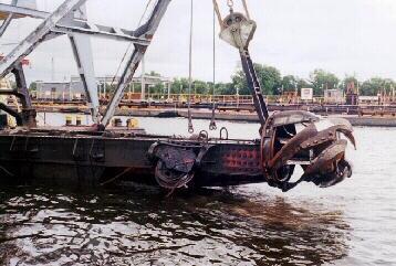
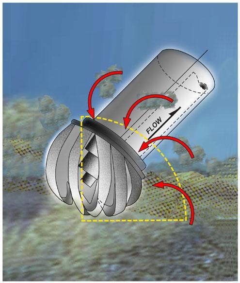
43 Figure 5-1. Cutterhead pipeline dredge schematic. 35

44 Hopper Dredge. The hopper dredge, or trailing suction dredge, is a self-propelled ocean-going vessel with a section of the hull compartmented into one or more hoppers. Fitted with powerful pumps, the dredges suck sediment from the channel bottom through long intake pipes, called drag arms, and store it in the hoppers. Normal hopper dredge configuration has two dragarms, one on each side of the vessel. A dragarm is a pipe suspended over the side of the vessel with a suction opening called a draghead for contact with the bottom. The dredged slurry is pumped into the vessel s hopper and allowed to settle and the water portion of the slurry discharged from the vessel through its overflow system. When the hopper attains a full load, dredging stops and the ship travels to an in-water disposal site, where the dredged sediment is discharged through the bottom of the ship by splitting the hull. Some hopper dredges are capable of pumping the material back out of the vessel through a series of shore-pipe to a designated placement location. Hopper dredges are well suited to dredging relatively thin layers of sediment. They can maintain operations safely, effectively, and economically in relatively rough seas and because they are mobile, they can be used in high-traffic areas. They are often used at ocean entrances and offshore, but cannot be used in confined or shallow areas. Hopper dredges can move quickly to placement sites under their own power, but since the dredging stops during the transit to and from the placement area, the operation loses efficiency if the haul distance is too far. Hopper dredges also have several limitations. Considering their normal operating conditions, hopper dredges cannot dredge continuously. The precision of hopper dredging is less than other types of dredges; therefore, they have difficulty dredging steep side banks and cannot effectively dredge around structures. In order to minimize the risk of incidental takes of sea turtles, the Corps requires the use of sea turtle deflecting dragheads on all hopper-dredging projects where the potential for sea turtle interactions exist. The leading edge of the deflector is designed to have a plowing effect of at least 6 depth when the drag head is being operated. Appropriate instrumentation is required on board the vessel to insure that the critical approach angle is attained in order to satisfy the 6 plowing depth requirement (USACE, 1993). Figure 5-2. Hopper dredge schematic. 36

45 Figure 5-3. Photograph taken from Manson Construction Company, Hopper Dredge Bayport. 37


46 Figure 5-4. Hopper dredge in operation and figure of draghead with turtle deflector. 38
47 5.02 Mechanical Dredges Mechanical dredges are characterized by the use of some form of bucket to excavate and raise the bottom sediment. They remove sediment by scooping it from the bottom and then placing it onto a waiting barge or directly into a placement area. Mechanical dredges work best in consolidated, or hard-packed, materials and can be used to clear rocks and debris. Dredging buckets have difficulty retaining loose, fine materials, which can be washed from the bucket as it is raised. Special buckets have been designed for controlling the flow of water and sediment from buckets and are used when dredging contaminated sediments. Mechanical dredges are rugged and can work in tightly confined areas. They are mounted on a large barge and are towed to the dredging site and secured in place by anchors or spuds. They are often used in harbors, around docks and piers, and in relatively protected channels, but are generally not well suited for areas of rough seas. Dipper dredges and clamshell dredges, named for the scooping buckets they employ, are the two most common types. A bucket dredge begins the digging operation by dropping the bucket in an open position from a point above the sediment. The bucket falls through the water and penetrates into the bottom material. The sides of the bucket are then closed and sediment is sheared from the bottom and contained in the bucket compartment. The bucket is raised above the water surface, swung to a point over the barge, and then released into the barge by opening the sides of the bucket. Usually two or more disposal barges, called dump scows, are used in conjunction with the mechanical dredge. While one barge is being filled, another is being towed to the placement site by a tug and emptied. If a diked disposal area is used, the sediment must be unloaded using mechanical or hydraulic equipment. Using numerous barges, work can proceed continuously, only interrupted by changing dump scows or moving the dredge. This makes mechanical dredges particularly well suited for dredging projects where the placement site is many miles away. The dipper dredge is essentially a power shovel mounted on a barge. It can dig hard materials and has all the advantages of the bucket dredge, except for its deep digging and sea state capabilities. Similar to the bucket dredge operation, the dipper dredge places sediment into a barge, which is towed to a disposal area (USACE, 1993) Bed Levelers A bed leveler is a device pulled or pushed along a dredged or dredged material placement area to smooth or remove humps of sediment lying above a target elevation. It can be used in place of a dredge during clean-up operations. A bed leveler would only be used after it has been demonstrated to NOAA Fisheries satisfaction that the device and method employed would be expected to result in no additional take of endangered species when compared to the alternative for accomplishing the required work. 39
; physical contact with dredging equipment and vessels (i.")

 or Savannah Outer Harbor (Ocean Bar Channel from Stations 0+000 to -97+680B).")
48 Photograph taken from Great Lakes Dredge & Dock Company, Dredge No. 52 Figure 5-5. Mechanical dredge (clamshell bucket and barge) Impacts of Hydraulic Dredges, Mechanical Dredges, and Bed-Levelers General Impacts. Dredging and placement of sediment have the potential to adversely affect animals and plants in a variety of ways. These include actions of the dredging equipment (i.e., cutting, suction, sediment removal, hydraulic pumping of water and sediment, and noise); physical contact with dredging equipment and vessels (i.e., impact); physical barriers imposed by the presence of dredging equipment (i.e., pipelines); and placement of excavated sediment in various placement locations (i.e., covering, suffocation). Potential impacts vary according to the type of equipment used, the nature and location of sediment discharged, the time period in relation to life cycles of organisms that could be affected, and the nature of the interaction of a particular species with the dredging activities. All the proposed work will occur in either the Savannah Inner Harbor (from near Stations to 0+000) or Savannah Outer Harbor (Ocean Bar Channel from Stations to B). Hydraulic cutter head pipeline dredges and/or mechanical dredges would be used to deepen the 40
49 inner harbor, while hopper, hydraulic, and/or mechanical dredges would be used to deepen the outer harbor. The pipeline dredges would pump the excavated sediment either to the existing seven confined disposal areas (CDFs). The hopper dredges and mechanical dredges would place any excavated material in the EPA-approved Ocean Dredged Material Disposal Site (ODMDS) Pipeline Dredges - Cutterhead Suction Dredge, Hopper Dredge and Mechanical Dredge. A. Lighting During Construction. Dredge plants and associated tugs and barges are required to meet Corps, US Coast Guard, and OSHA lighting standards for safety. With regard to sea turtles, lighting is only an issue during hatching. The hatchlings may be disoriented by bright lights and head toward those lights instead of toward the ocean. However, since hatching only occurs during the warmer months and no dredging operations near the beaches are proposed during that period, lighting on dredge equipment will not affect sea turtles. During this dredging project, additional lighting impacts may occur on the CDFs, floating pipeline (near the dredge and placement area) and associated heavy equipment working on the site to move anchors, etc. Ample lighting on a hopper dredge is specifically required for the observers on board to provide safe access at night to the inflow boxes and screens. B. Dredge plume. Studies performed by Dr. D.F. Hayes in 1986 on a hydraulic cutterhead dredge operating in Savannah Harbor indicated that average suspended sediment concentrations within 1,600 feet of the dredge were generally raised less than 200 mg/l in the lower water column and less than 100 mg/l and 50 mg/l in the middle and upper water column, respectively. The Savannah River has a naturally high suspended sediment load which during storm events increases well beyond the 200 mg/l increase created by a hydraulic dredge. In addition, during storm events the higher suspended sediment loads would likely be more uniform throughout the water column due to mixing as the plume proceeds down stream. Hopper dredges would predominantly be used within the ocean bar channel (Stations to ) of the harbor. Hopper dredge suction arms hydraulically remove sediment from the navigation channel and discharge the material into the storage hoppers on the dredge. During filling, fine sediments (primarily silt, clays, and fine-sands) are washed overboard to maximize the load of coarse sediments transported to the placement site. This washing and overflow process is a source of turbidity plumes and sedimentation generated by the hopper dredge. The distance that sediment plumes may extend is dependent upon the type of dredge, how it is operated, currents, and the nature of the sediments within the excavation area. Elevated sediment levels from hopper dredge operations have been recorded at about 1,100 feet from an excavation site (Blair et al. 1990). Furthermore, according to Neff (1981 and 1985), concentrations of 1000 ppm immediately after discharge decreased to 10 ppm within one hour. The minimal impact of settling particles from hopper dredge turbidity plumes was further supported by a study from Poopetch (1982), which found that the initial hopper dredge overflow concentrations of 3,500 mg/l were reduced to 500 mg/l within 50 meters. Another source of turbidity and sedimentation from hopper dredges is through the deposition of their sediment loads at the placement sites. 41
50 Mechanical dredges could be used throughout the proposed project (Station to B). The primary time when turbidity would be generated would be when the full bucket travels through the water column to the surface and is empted into an adjacent barge. However, the magnitude of the river flows (i.e., the Savannah River has an average discharge of 11,290 cubic feet per second) indicate that rapid dilution of effects can be expected. Moreover, turbidity within the ocean bar would be quickly dissipated due to currents, wind and wave action. D. Bed Leveler. Bed-levelers are currently permitted for certain reaches of the upper harbor with conditions required to minimize turbidity impacts. The use of bed levelers is requested as a part of this biological assessment. If approved by NOAA, the Corps will abide by any conditions associated with their use. The project proposes to also authorize their use in the Bar Channel. Furthermore, their use would be restricted to the leveling of high spots in the channel or placement area where use of a hopper dredge for such work would be expected to result in equal or greater take of endangered species. E. Noise. Within any harbor there are a number of noise sources. Ships arriving and departing (including tugs, etc.), recreational boats, dredges (cutterhead suction, mechanical, and hopper), wharf/dock construction (pile driving, etc.), wharf/dock operations (loading and unloading vessels), and natural (wind, storms, biological, etc.) all make up the harbor ambient noise. The following information was taken from ATM (2004): High levels of noise are generated from pile driving (either impact hammer or vibratory hammer). Impact pile driving according to Carlson (1997) on timber piles ranged from to db and Widener (2002) on steel piles ranged from to db. According to the NOAA fisheries (NOAA 2001), the Biological Opinion (BO) for the San Francisco-Oakland Bay Bridge East Span Seismic Safety Project considered noise an adverse effect to salmon at the following levels: 150 db (0.03 kpa) the level of take 180 db (1kPa) the level of physical harm 204 db (over 10kPa) the level of instantaneous death To comply with this NOAA Biological Opinion a fisheries biologist needed to be present to monitor pile driving noise (ATM 2004). No additional monitoring was needed if hydroacoustic monitoring from the first five piles did not indicate noise levels exceeding 150 db at three meters depth and 10 meters away. If noise levels exceeded 150 db 50% of the time or less and was not greater than 180 db for the first five pilings, work could continue with monitoring in place. If noise levels exceeded 180 db, then sound attenuation devices (i.e., sheet pile coffer cell, bubble curtain, etc.) would be required (ATM 2004). In order to deepen the Wilmington Harbor navigation channel in the Cape Fear River, rock was blasted to attain the authorized depth. Anadromous fish (Striped Bass, American shad, Hickory shad, blueback herring, etc), Shortnose sturgeon, and marine mammals are found within that portion of the river that was to be deepened by blasting. Moser (1999) and Rickman (2000) conducted a study within the Cape Fear River setting off test blasts and measuring the effects and blast pressure on caged fish (white mullet, cyprinodontids, and hatchery reared Striped bass and Shortnose sturgeon) arranged certain distances from the blast. ATM (2004) indicated that the underwater blasts were measured at 75 psi (234 db peak) and 18 psi root mean square (RMS) 42
51 impulse of (221 db impulse). Bubble curtains were used in some of the tests, but failed to be effective due to the river current deflecting them. Greater than 140-feet from the blast, there was no impact to the caged fish when compared to the control (Moser 1999). Richardson (Richardson et al 1995) speculates that for marine mammals the following underwater noise levels may be detrimental: Prolonged Exposure of 140 db re 1 micro Pascals (continuous manmade noise), at 1 km may cause Permanent Hearing Loss* Prolonged Exposure of 195 to 225 db re 1 micro Pa (intermittent noise), at a few meters or tens of meters, may cause Immediate Hearing Damage* Richardson states that Many marine mammals would avoid these noisy locations, although it is not certain that all would do so. According to Richardson et al (1995), received noise levels diminish by about 60 db between the noise source and a radius of 1 km. For marine mammals to be exposed to a received level of 140 db at 1 km radius, the source level would have to be about 200 db re 1 micro Pa-m (Richardson et al 1995). Richardson et al (1995) states that few human activities emit continuous sounds at source levels greater than or equal to 200 db re 1 micro Pam. According to Richardson et al (1995) supertankers and icebreakers may exceed the 195 db noise levels. According to Clarke (Clarke et al 2002), the underwater noise from a cutterhead suction dredge is continuous and muted. The noise is generated from the cutterhead rotating within the soft bottom sediment and from the pumps used to transport the effluent to the placement area. The majority of the sound generated was from 70 to 1,000 Hz and peaked at 100 to 110 db range. Noise from the cutterhead suction dredge became almost inaudible at about 500 meters (Clarke et al 2002 unpublished). These results from Clarke et al are preliminary and have not been published. The noise generated from a hopper dredge is similar to a cutterhead suction dredge except there is no rotating cutterhead. The majority of the underwater noise is generated from the dragarm sliding along the bottom, the pumps filling the hopper, and operation of the ship engine/propeller. Like the cutterhead suction dredge, the noise ranged from 70 to 1,000 Hz and peaked at 120 to 140 db (Clarke et al 2002). These results from Clarke et al are preliminary and have not been published. The underwater noise generated from a mechanical dredge entails lowering the open bucket through the water column, closing the bucket after impact on the bottom, lifting the closed bucket up through the water column, and emptying the bucket into an adjacent barge. Once the barge is full, it is towed by a tug offshore and empted either in the submerged berms adjacent to the ocean bar channel or the Savannah ODMDS. According to discussions with Doug Clarke and Charles Dickerson, US Army Engineer Research and Development Center for mechanical dredges the maximum underwater noise spike is when the bucket hits the bottom. All other noises from this operation (i.e., winch motor, spuds, etc.) are insignificant. The sediment within Savannah Harbor is predominantly sand/silt/mud/clay mixture. No rock, gravel, or cobbles are 43
52 located within the portion of the navigation channel to be deepened. According to Clarke et al (2002), the peak amplitude for the bucket hitting the rocky, gravel, cobble bottom at Cook Inlet, Alaska was about 120 db. Both Doug Clarke and Charles Dickerson (US Army Engineer Research and Development Center) stated that this peak amplitude of the bucket hitting the existing sand/silt/mud substrate of Savannah Harbor would be significantly less than 120dB PROPOSED CONDITIONS Dredging and disposal methods associated with the proposed deepening of the Savannah Harbor Navigation Project are generally similar to current maintenance dredging methods. At this time, approximately 7 million cubic yards of sediments are removed each year from the Savannah Harbor Navigation Project by the Corps. The dredged sediment is placed in one of the seven CDFs which have been designated for use for the project, the nearshore feeder berm sites off Tybee Island and adjacent to the ocean bar channel or the Savannah ODMDS. These methods have been addressed in a number of previous environmental documents (USACE 1991 and USACE 1996), including biological assessments and biological opinions rendered regarding threatened and endangered species. A more detailed description of the existing conditions is located in Section 4.0 of the EIS. The Selected Plan would deepen the existing -42 foot authorized Federal navigation channel to - 47 feet. The Corps will use pipeline and/or mechanical dredges within the inner harbor (Stations to 4+000) and pipeline, mechanical, and/or hopper dredges in the outer harbor (Stations to B). The proposed construction would not place any excavated dredged sediment from the harbor deepening on Tybee Island beach or in any of the nearshore feeder berm sites off Tybee Island or Sites 2 and 3 adjacent to the entrance channel. The Corps proposes to place new work sediments from the harbor deepening in the existing CDFs or the ODMDS. Maintenance sediments may be placed on Tybee Island beach or in the nearshore feeder berm sites off Tybee Island or Sites 2 and 3 adjacent to the entrance channel. Within the outer harbor (Stations to B) the following equipment would work: 1. A pipeline and/or mechanical dredge would work throughout the year. 2. A hopper dredge would work from 1 December to March 31 of any year as stated in the Biological Opinion. The occurrence of a particular protected species within the project area depends upon the availability of suitable habitat, the season of the year relative to the species' temperature tolerance and migratory habits, and other factors. 44
53 7.00 IMPACTS TO GEORGIA AND SOUTH CAROLINA PROTECTED SPECIES AND SPECIAL CONCERN ANIMALS AND PLANTS AND NATURAL COMMUNITIES Section 8.0 discusses impacts to Federally-listed T&E species and will not be duplicated in Section Primary and Secondary Impacts. The proposed deepening and continued maintenance of the Savannah Harbor Navigation Project will primarily affect palustrine, estuarine and marine habitats. Some direct impacts to marsh and/or wetlands, and adjacent shallow water habitats will occur as a result of excavation during the proposed action. No wet Savannas, Carolina Bays, vernal pools, wet pine flats, sandhills, or oak/pine flats would be excavated by the proposed action. The vast majority of work occurring on uplands would take place at the existing seven CDFs which the Corps uses annually for the placement of harbor maintenance sediments. More detailed information is found in Section 3.01 of the EIS. Sediment sampling and analyses conducted in 2005 concluded that the only sediment contaminant of concern that would be dredged during construction of the Savannah Harbor Expansion Project is naturally-occurring cadmium found in Miocene clays. The highest concentrations of cadmium (average mg/kg) are found between Stations and (River Mile 3.0 to 8.5) and medium concentrations (average of 6.67 mg/kg) are found between Stations to (River Mile 8.5 to 17.8). The sediment evaluation for the proposed deepening of the Federal navigation channel found minimal potential for contaminantrelated impacts to estuarine and marine species within the Savannah River. About 7.8 MCY cubic yards of dredged sediment contain cadmium (from Stations to , to , and to ). All of the cadmium-laden sediments would be placed and retained in existing CDF 14A and/or 14B and covered with about 2-feet of dredged sediment taken from the Federal navigation channel where cadmium concentrations are thought to be 4 mg/kg or less. This new work dredged sediment within CDFs 14A and 14B will not be used for future dike raisings or used for borrow material. Direct impacts of the proposed deepening would include an upstream shift in salinity and reduced dissolved oxygen (DO) levels in deepened channel waters. The upstream limit of the increased salinity and lowered DO would remain downstream of the I-95 bridge across the Savannah River (about Station ). Therefore, the proposed action will not affect any adjacent freshwater marsh and/or wetlands upstream of the I-95 bridge. The pages that follow describe potential impacts to individual species from construction and maintenance of the proposed work. Part of the description includes identification of present conservation status of the species. The conservation status scale used in this analysis was obtained from NatureServe.org whenever possible, and listed at the state (S) geographic level. Status assessments are based on the best available information, and consider a variety of factors such as abundance, distribution, population trends, and threats. The scale has the following definitions: 45
54 1 = critically imperiled 2 = imperiled 3 = vulnerable to extirpation or extinction 4 = apparently secure 5 = demonstrably widespread, abundant, and secure.? = Inexact Numeric Rank Denotes some uncertainty about the numeric rank (e.g. S3? - Believed most likely a S3, but some chance of either S2 or S4). S#S# = Range Rank A numeric range rank (e.g., S2S3) is used to indicate any range of uncertainty about the status of the species or community. Ranges cannot skip more than one rank (e.g., SU is used rather than S1S4). SNR = Unranked State/province conservation status not yet assessed. SH or NH = Possibly Extirpated (Historical) Species or community occurred historically in the nation or state/province, and there is some possibility that it may be rediscovered. Its presence may not have been verified in the past years. A species or community could become NH or SH without such a year delay if the only known occurrences in a nation or state/province were destroyed or if it had been extensively and unsuccessfully looked for. The NH or SH rank is reserved for species or communities for which some effort has been made to relocate occurrences, rather than simply using this status for all elements not known from verified extant occurrences Species Listed for Chatham County, Georgia. The following animal species will not be adversely affected by the proposed deepening because their habitat is either upland (i.e., sandy longleaf pine ridges, etc.), isolated wetlands (i.e., bogs, Carolina Bays, etc.), or river substrate that is sandy to rocky: Brimley s Chorus Frog (Pseudacris brimleyi) Gopher Tortoise (Gopherus polyphemus) The following animal species will not be adversely affected by the proposed deepening because, although the species has been recorded twice in the areas, it is not expected to be present on a regular basis: Gray Kingbird (Tyrannus dominicensis). 46
55 GEORGIA ANIMALS Spotted Turtle (Clemmys guttata) a. Status. S3 Vulnerable b. Background. Mostly unpolluted, small, shallow bodies of water such as small marshes, marshy pastures, bogs, fens, woodland streams, swamps, small ponds, and vernal pools; also occurs in brackish tidal streams. Ponds surrounded by relatively undisturbed meadow or undergrowth are most favorable. Favors waters with soft bottom and aquatic vegetation. Often basks along water's edge, on brush piles in water, and on logs or vegetation clumps. May spend much time on land in some areas during certain seasons. When inactive, hides in bottom mud and detritus, or in muskrat burrow. c. Project Impact. No alterations to marsh/wetlands or shallow water habitats are expected that would be detrimental to this species. d. Effect Determination. No effect American Oystercatcher (Haematopus palliatus) a. Status. S2 Imperiled b. Background. Georgia habitat is sandy beaches, tidal flats, and salt marshes. c. Project Impact. No new work dredged material would be placed onto beaches or tidal flats or into salt marshes. Maintenance material could be placed in the feeder berm sites in the nearshore area off Tybee Island or on the beach at Tybee Island. This could provide a temporary interruption to use of the beach as foraging habitat for the American oystercatcher. d. Effect Determination. May affect, not likely to adversely affect this species or any of its presently designated critical habitat Black-necked stilt (Himantopus mexicanus) a. Status. S3 Vulnerable b. Background. Feeds in shallow salt or fresh water with soft muddy bottom; grassy marshes, wet savanna, mudflats, shallow ponds, flooded fields, borders of salt ponds. Nests along the shallow water of ponds, lakes, swamps, or lagoons. May also nest on the ground or in shallow water on a plant tussock. c. Project Impact. This species sometimes feeds in intertidal areas and tidal pools. Blacknecked stilts commonly use the CDFs for breeding, feeding, and loafing. Sediment deposition within the CDFs provides nesting and feeding habitat for stilts and would be conducted in a manner to minimize interference with nesting stilts. It is expected that some birds may feed 47
56 along the edges of the CDFs in which cadmium-containing sediments would be placed. Since the sediments would be held underwater and the cover placed while the sediments are inundated, cadmium exposure is expected to be minimal. d. Effect Determination. May affect, not likely to adversely affect this species or any of its presently designated critical habitat Black-crowned Night-heron (Nycticorax nycticorax) a. Status. S4 Apparently secure b. Background. The breeding season begins in mid-march, peaks in mid-april to mid-may, and extends until the middle of June. Breeding habitat consists of wetland areas, including swamps, mangroves, and marshes. The species nests in colonies, with many birds nesting in the same area together. Non-breeding habitat is associated with wetlands. The diet includes fish, aquatic invertebrates, eggs and young birds, and other small vertebrates. The Black-crowned Nightheron captures aquatic prey by standing in or near the water to capture food. c. Project Impact. This species feeds primarily in wetlands, marshes and intertidal areas. Blackcrowned Night-herons use the CDFs for breeding, feeding, and loafing. Sediment deposition within the CDFs provides feeding habitat for the birds. It would be conducted in a manner to not interfere with nesting herons. The project is not expected to impact food resources or habitat used by this species. d. Effect Determination. May affect, not likely to adversely affect this species or any of its presently designated critical habitat False Killer Whale (Pseudorca crassidens) a. Status. Georgia Species of Special Concern b. Background. Habitat is open ocean. c. Project Impact. Hopper dredging of the ocean bar channel could lead to an encounter with this species. However, the conditions in the current NMFS Regional Opinion dated 1997 and the SAD Protocol, which the District would also abide by as long as the opinion is in effect, include the following: Monitoring by endangered species observers with at-sea large whale identification experience to conduct daytime observations for whales between December 1 and March 31. During daylight hours, the dredge operator must take necessary precautions to avoid whales. During evening hours or when there is limited visibility due to fog or sea states of greater than Beaufort 3, the dredge must slow down to 5 knots or less (or lowest safe speed) when transiting between areas if whales have been spotted within 15 nautical miles (nm) of the vessel's path within the previous 24 hours. (Contractors will be required to use daily available information on the presence of whales in the project area.) One hundred percent dedicated daytime whale/endangered species observer coverage is required between December 1 and March
57 With or without the proposed harbor deepening, the total number of vessels is expected to increase in the future in response to rising demands for exports and imports. Vessels would be able to load more deeply under the improved conditions, so (when comparing With and Without Project conditions) fewer vessels would be required to carry the cargo in a given year. This reduction in the number of vessels with the deepening project would reduce the number of potential ship/whale encounters. d. Effect Determination. Because of the habitat preferences of this species, potential effects are expected to be minimal. Since the number of vessels calling on the harbor is expected to decrease as a result of the proposed project, no effects are expected on this species. May affect, but not likely to adversely affect this species or any of its presently designated critical habitat Black Skimmer (Rynchops niger) a. Status. S1 Critically Imperiled b. Background. The breeding season begins in early May and lasts through mid-august. Skimmers nest on beaches or sandy islands. The nest is a scrape created by both the male and female. The young have mandibles of equal length when they are young, which helps them pick up insects and food from the adults. The young gain their unequal mandible length when they are old enough to forage on their own. In winter, most of this bird's time is spent resting on the beaches of the coast or skimming over the water. When a food item is found, the Black Skimmer "nods" its head to close the prey in its bill. It eats fish, aquatic invertebrates, and crustaceans. c. Project Impact. No new work dredged material would be placed onto beaches or sandy islands. Maintenance material could be placed in the nearshore feeder berm sites off Tybee Island or on the beach at Tybee Island. To protect nesting sea turtles, this placement could only occur from 1 August to 30 April of any year. This placement period would also avoid impacts to nesting Black skimmers. d. Effect Determination. This species nests on interior islands within the CDFs. Suitable nesting habitat will be maintained yearly so that the proposed action will not affect breeding, nesting or loafing areas. May affect, but not likely to adversely affect this species or any of its presently designated critical habitat Least Tern (Sterna antillarum) a. Status. S3 Vulnerable b. Background. Habitat is sandy beaches and sandbars. c. Project Impact. Least terns commonly use the CDFs for breeding, feeding, and loafing. Sediment deposition within the CDFs produces feeding habitat for the terns and would be conducted in a manner to not interfere with nesting terns, in compliance with the Migratory Bird Treaty Act. Specifically, management of the CDFs for birds has been and will continue to be 49
58 performed in accordance with the 1996 LTMS. In essence, the LTMS states that when the existing CDFs are used for sediment placement, they will remain wet for 3 years and then dry for 3 years. Thus, generally about half the CDFs are wet and the other half dry at any given time, and some CDFs will be available for breeding, feeding and loafing each year. The CDFs are monitored for colonial nesting birds and Black-necked Stilts. The dredger is required to set his head section so he won't flood any nests on sands around the head section. The Corps also holds water in the CDFs as high as possible prior to the onset of nesting to force the stilts to nest as high as possible in the areas so their nests won't be impacted by subsequent sediment disposal operations conducted during the nesting season. Construction of the project would not involve the placement of any new work material into the nearshore area off Tybee Island or onto Tybee Island beach. However, these areas could be used for placement of maintenance material from the project. This could temporarily impact use of these sites by this species. d. Effect Determination. The proposed action may affect breeding, nesting or loafing areas (within the CDFs). May affect, but not likely to adversely affect this species or any of its presently designated critical habitat Seaside Sparrow (Ammodramus maritimus) a. Status. S3 b. Background. Seaside Sparrow (Ammodramus maritimus), a sparrow that is almost always found in salt and brackish marshes, occurs along the Atlantic Coast of the United States from New Hampshire to central Florida (where it is now extirpated as a breeder), and along the Gulf Coast from central Florida to central Texas. c. Project Impact. The proposed deepening of the Savannah Harbor Navigation Project will primarily affect palustrine, estuarine and marine habitats. Some direct impacts to marsh and/or wetlands, and adjacent shallow water habitats would also occur as a result of excavation during the proposed action. The marsh that will be excavated is primarily smooth cordgrass growing along the shoreline of the river and would not adversely impact this species. d. Effect Determination. This species nests on interior islands within the CDFs. Suitable nesting habitat will be maintained yearly so that the proposed action will not affect breeding, nesting or loafing areas. May affect, but not likely to adversely affect this species or any of its presently designated critical habitat Wilson s Plover (Charadrius wilsonia) a. Status. S2 b. Background. Wilson s Plovers nest on sparsely vegetated saline areas, including beaches above high tide, dune areas, and edges of lagoons. They are territorial during the nesting season but engage in group defense of their nesting areas. During the nonbreeding season, individuals 50
59 congregate in groups of up to 30 or more, sometimes with other species of small plovers, for roosting and foraging. Wilson s Plovers feed primarily on crustaceans, particularly fiddler crabs (Uca spp.). c. Project Impact. Project impacts to this species are expected to be minimal. d. Effect Determination. This species nests regularly in open or lightly vegetated areas of the CDFs. Continued operation of the CDFs is necessary to produce nesting habitat for this species. The Corps plans to continue monitoring nesting of this species within the CDFs to avoid impacts to nests and foster continued nesting success. May affect, but not likely to adversely affect any of its presently designated critical habitat Eastern Diamondback Rattlesnake (Crotalus adamanteus) a. Status. S4 b. Background. Crotalus adamanteus can be found in the palmetto flatwoods and dry pinelands of South Eastern United States. It can be found from the coastal lowlands of southeast North Carolina to the extreme east of Louisiana, with the main concentration located in the state of Florida. This species is regularly observed in the CDFs located in South Carolina. This species has also been known to venture into salt water. c. Project Impact. The proposed deepening of the Savannah Harbor Navigation Project will primarily affect palustrine, estuarine and marine habitats. Some direct impacts to marsh and/or wetlands, and adjacent shallow water habitats would also occur during the proposed action. Sediment deposition in the CDFs occurs slowly allowing individuals to escape from the ponded water. When the dikes are raised, heavy equipment is used to move and shape dirt on the dikes. The vibrations from this heavy equipment may be sensed by the species, allowing them to avoid the activity. The project intends to continue to include conditions in its construction specifications requiring there be no intentional harming or killing of this species. d. Effect Determination. May affect, but not likely to adversely affect any of its presently designated critical habitat Bald Eagle (Haliaeetus leucocephalus) a. Status. S2 b. Background. The Bald Eagle prefers habitats near seacoasts, rivers, large lakes, oceans, and other large bodies of open water with an abundance of fish. c. Project Impact. The proposed deepening of the Savannah Harbor Navigation Project will primarily affect palustrine, estuarine and marine habitats. Some direct impacts to marsh and/or wetlands, and adjacent shallow water habitats would also occur during the proposed action. Bald Eagles are periodically observed foraging at the CDFs. The proposed continued use of the CDFs should not measurably affect this foraging activity. 51
60 d. Effect Determination. May affect, but not likely to adversely affect any of its presently designated critical habitat Migrant Loggerhead Shrike (Lanius ludovicianus migrans) a. Status. S3 b. Background. Shrikes are characteristically birds of open country (e.g., pastures with fence rows, old orchards, mowed roadsides, cemeteries, golf courses, agricultural fields, riparian areas, and open woodlands. They occur from deserts and prairies in the West to pastures and fields in the East. Longleaf pine (Pinus palustris) savannas and open, mature stands of loblolly pine (P. taeda)-shortleaf pine (P. echinata) also provide suitable habitat for the shrike in the Southeast. The species occurs irregularly within the disposal areas, but has been observed outside of the dikes. There is one summer record (one individual on July 6, 2006) and about forty-four fall and winter records of single individuals from August 14 (1 in 2003) to March 8 (1 in 2007). There are three records of two individuals on October 27, 2007, November 17, 2007, and November 18, c. Project Impact. The proposed deepening of the Savannah Harbor Navigation Project will primarily affect palustrine, estuarine and marine habitats. Some direct impacts to marsh and/or wetlands, and adjacent shallow water habitats will also occur during the proposed action. d. Effect Determination. May affect, but not likely to adversely affect any of its presently designated critical habitat Northern Yellow Bat (Lasiurus intermedius) a. Status. S2 S3 b. Background. Northern yellow bats (Lasiurus intermedius) are foliage roosting bats. Foliage roosting bats hang under leaves and branches, or, in the case of northern yellow bats, often under Spanish moss. These bats forage over open areas, such as fields, pastures, golf courses, marshes and along lake and forest edges. This species has not been observed in the CDFs. c. Project Impact. The proposed deepening of the Savannah Harbor Navigation Project will primarily affect palustrine, estuarine and marine habitats. Some direct impacts to marsh and/or wetlands, and adjacent shallow water habitats will also occur during the proposed action. d. Effect Determination. May affect, but not likely to adversely affect any of its presently designated critical habitat. 52
61 Robust Redhorse (Moxostoma robustum) a. Status. S1 b. Background. Habitat loss and disruption of spawning migrations resulting from dams and impoundments, predation by introduced non-native species, and significant deterioration of water quality due to sedimentation and pollution are believed to have contributed to the decline of the species. The robust redhorse is uncommon in the Ocmulgee, Savannah and Pee Dee rivers. c. Project Impact. The proposed deepening of the Savannah Harbor Navigation Project will primarily affect palustrine, estuarine and marine habitats. Constructing the fish bypass at New Savannah Bluff Lock and Dam would allow passage to historic upstream spawning areas at the Augusta Shoals (which would provide additional spawning habitat to this species). d. Effect Determination. Minor beneficial effect on this species. May affect, but not likely to adversely affect any of its presently designated critical habitat Yellow Crowned Night Heron (Nyctanassa violacea) a. Status. S3 S4 b. Background. Breeding habitat is wetland areas, including swamps, marshes, bottomland forests, and river systems. The diet is primarily crustaceans, especially crayfish and crabs, but also includes fish, aquatic invertebrates, eggs and young birds, and other small vertebrates. The Yellow-crowned Night-heron captures aquatic prey by standing in or near the water. This species forages at night and roosts during the day. c. Project Impact. Yellow Crowned Night Heron commonly use the CDFs for breeding, feeding, and loafing. Sediment deposition within the CDFs produces feeding habitat for these species and would be conducted in a manner to not interfere with nesting Yellow Crowned Night Herons. Specifics regarding the management of the CDFs to minimize impacts to birds are included above, in Section d. Effect Determination. The proposed action may affect breeding, nesting or loafing areas (within the CDFs). May affect, but not likely to adversely affect any of its presently designated critical habitat Painted Bunting (Passerina ciris) a. Status. S3 b. Background. The Painted Bunting is found in thickets, woodland edges and brushy areas, along roadsides, in suburban areas, and gardens. Painted Bunting depends on young shrub and grassland habitat for breeding and nesting primarily in upland maritime shrub-scrub habitat of 53
62 the South Atlantic Coastal Plain from North Carolina to northeastern Florida. Painted Buntings can also use shrub-scrub habitat in open pine and maritime oak forests. c. Project Impact. The proposed deepening of the Savannah Harbor Navigation Project will primarily affect palustrine, estuarine and marine habitats. Some direct impacts to marsh and/or wetlands, and adjacent shallow water habitats would also occur during the proposed action. The continued use of the CDFs should not adversely affect this species. d. Effect Determination. May affect, but not likely to adversely affect this species or any of its presently designated critical habitat Gopher Frog (Rana capito) a. Status. S3 b. Background. Gopher Frogs frequently inhabit the occupied or unoccupied burrows of Gopher Tortoises (Gopherus polyphemus) in the Deep South. These frogs can be found at night, feeding or calling outside of their burrows in pine flatwoods and other dry habitats, and can be found during the breeding season in ponds associated with these habitats. Fishless ponds are required for successful reproduction to occur. This species has not been observed at the CDFs. c. Project Impact. The proposed deepening of the Savannah Harbor Navigation Project will primarily affect palustrine, estuarine and marine habitats. Some direct impacts to marsh and/or wetlands, and adjacent shallow water habitats would also occur during the proposed action. d. Effect Determination. May affect, but not likely to adversely affect any of its presently designated critical habitat Many Lined Salamander (Stereochilus marginatus) a. Status. S3 b. Background. Many Lined Salamander can be found in the cypress and gum swamps, small ponds in pine forests, large drainage ditches, and sluggish streams. Adults occur in moss or under leaf debris in water, or under objects at water's edge. It is primarily freshwater aquatic. Eggs are laid in or under logs or attached to plants in or near water. c. Project Impact. The proposed deepening of the Savannah Harbor Navigation Project will primarily affect palustrine, estuarine and marine habitats. Some direct impacts to marsh and/or wetlands, and adjacent shallow water habitats would also occur during the proposed action. d. Effect Determination. May affect, but not likely to adversely affect this species or any of its presently designated critical habitat. 54
63 Eastern Mudminnow (Umbra pygmaea) a. Status. S2 S3 b. Background. Occur in quiet freshwater streams, sloughs, swamps and other wetlands over sand, mud and debris, often among dense vegetation. Juveniles also found among aquatic vegetation. c. Project Impact. The proposed deepening of the Savannah Harbor Navigation Project will primarily affect palustrine, estuarine and marine habitats. Some direct impacts to marsh and/or wetlands, and adjacent shallow water habitats would also occur during the proposed action. Some of the proposed mitigation activities would occur in freshwater areas, so there is the potential to encounter this species. d. Effect Determination. May affect, but not likely to adversely affect this species or any of its presently designated critical habitat. GEORGIA PLANTS The following plant species will not be adversely effected by the proposed deepening because their habitat is either upland (i.e., sandy ridges, longleaf pine savannas, etc.), wet savannas or isolated wetlands (i.e., bogs, Carolina Bays, etc.). Sweet Acacia (Acacia farnesiana) Florida Privet (Forestiera segregata) Pineland Beaksedge (Rhynchospora punctata) Climbing Buckthorn (Sageretia minutiflora) Soapberry (Sapindus marginatus) Hooded Pitcherplant (Sarracenia minor) Skullcap (Scutellaria mellichampii). Pineland Dropseed (Sporobolus pinetorum) Narrowleaf Obedient Plant (Physostegia leptophylla) a. Status. S2 Imperiled b. Background. Georgia habitat is freshwater and brackish tidal marshes; disjunct in wet savannas of extreme Southwest Georgia. This species has ecological value, but since this species is not a federally listed threatened or endangered species, a detailed survey is not warranted. c. Project Impact. This species is not known to exist within the project area and would not be expected to occur within the area, but its habitat is similar to what is found in portions of the estuary. d. Effect Determination. May affect, but not likely to adversely affect this species or any of its presently designated critical habitat. 55
64 Swamp Hibiscus (Hibiscus grandiflorus) a. Status. S2 b. Background. Tidal marshes, coastal flatwoods; wet savannas. This species has ecological value, but since this species is not a federally listed threatened or endangered species, a detailed survey is not warranted. c. Project Impact. This species is not known to exist within the project area and would not be expected to occur within the area, but its habitat is similar to what is found in portions of the estuary. d. Effect Determination. May affect, but not likely to adversely affect this species or any of its presently designated critical habitat Wild Yellow Cowpea (Vigna luteola) a. Status. S2? b. Background. Open swamps; maritime beaches and tidal flats. This species has ecological value, but since this species is not a federally listed threatened or endangered species, a detailed survey is not warranted. c. Project Impact. This species is not known to exist within the project area and would not be expected to occur within the area, but its habitat is similar to what is found in portions of the estuary. d. Effect Determination. If this species is present, the project may affect, but is not likely to adversely affect the species or any of its presently designated critical habitat Conservation Areas, Chatham County, Georgia The following conservation areas in Chatham County, Georgia will not be adversely affected by the proposed deepening of the navigation channel since they are located on uplands or some distance from the project site (Greenspace in Chatham County, Little Tybee Island and Cabbage Island, Skidaway Island State Park, Wormsloe Historic Site, which is located on the Isle of Hope, about ten miles south of Savannah). The following conservation areas may be affected by the proposed action: Fort Pulaski National Monument [National Park Service]. By deepening the proposed Federal navigation channel, the ongoing erosion of the riverine shoreline could be increased by shipgenerated wakes. The Corps conducted ship wake and bank erosion studies and determined that no significant impacts to shoreline erosion are expected from the proposed action (see Engineering Appendix to the GRR). 56
65 Savannah National Wildlife Refuge (NWR) [U.S. Fish and Wildlife Service]. By deepening the Federal navigation channel, increased salinity is expected to impact existing freshwater tidal marsh within the Savannah NWR. The effects would be mitigated by various components of the mitigations plans, including the flow re-routing features and the land acquisition and preservation. A portion of the Savannah NWR is located in South Carolina. Savannah River [High Priority Stream]. The Savannah River will be adversely impacted by increased salinity impacts from the proposed action. As a result of the mitigation plan (see Appendix C), the overall effect on the river and its fisheries are not expected to be significant. The dissolved oxygen within the harbor will be maintained and slightly improved by oxygen injection. A portion of the Savannah River is located in South Carolina Species Listed for Jasper County, South Carolina. The following animal species will not be adversely effected by the proposed deepening because their habitat is either upland (i.e., caves, sandy longleaf pine ridges, etc.), isolated wetlands (i.e., bogs, Carolina Bays, etc.), or river substrate that is sandy to rocky. Rafinesque s big-eared Bat* (Corynorhinus rafinesquii) Eastern Diamondback rattlesnake (Crotalus adamanteus) Gopher tortoise (Copherus polyphemus) Southern hognose snake (Heterodon simus) Eastern Woodrat (Neotoma floridana) (Neotoma floridana floridana) Mimic glass lizard (Ophisaurus mimicus) Florida pine snake (Pituophus melenoleucus mugitus) Eastern fox squirrel (Sciurus niger) Rayed pink fatmucket (Lampsilis splendida) Bird voiced treefrog (Hyla avivoca) *Note: Rafinesque s Big-Eared Bat (Corynorhinus rafinesquii), roosts in bottomland hardwood trees, which could be affected by salinity. SOUTH CAROLINA ANIMALS Bachman s Sparrow (Aimophila aestivalis) a. Status. S3 Vulnerable b. Background. Habitat specialist. Historically, found in mature to old growth southern pine woodland subject to frequent growing-season fires; a fugitive species, breeding wherever fires created suitable conditions. Requires well-developed grass and herb layer with limited shrub and hardwood midstory components. Ideal habitat was originally the extensive longleaf pine woodlands of the south. In the southeastern U.S., Coastal Plain breeding habitat usually is open pine woods with thick cover of grasses or saw palmetto. In South Carolina, higher densities 57
66 were recorded in mature (more than 80 years old) pine stands than in young stands. These habitats are not present within the immediate project area. c. Project Impact. No impact to feeding, nesting, or loafing areas. d. Effect Determination. No effect Barrel Floater (Anodonta couperiana) a. Status. Not ranked/ Under review. b. Background. Freshwater mussel, habitat is slow streams, mud and sand substrate. Has been recorded in Jasper County, but there are no known occurrences of the barrel floater in the project area (Personal Communication, Julie Holling, SC Department of Natural Resources, Heritage Trust Program, March 1, 2011). This species has ecological value, but since this species is not a federally listed threatened or endangered species, a detailed survey is not warranted. c. Project Impact. This species is not known to exist within the immediate project area, but its habitat is similar to what is found in portions of the estuary. If this species is found downstream of McCoy s Cut in the Front, Middle or Back Rivers, the proposed action would increase salinity and change the tidal freshwater habitat to a brackish habitat. d. Effect Determination. If the species is present, the change from freshwater to brackish habitat may affect this species. May affect, but not likely to adversely affect this species or any of its presently designated critical habitat Spotted Turtle (Clemmys guttata) a. Status. S5 Secure b. Background. Mostly unpolluted, small, shallow bodies of water such as small marshes, marshy pastures, bogs, fens, woodland streams, swamps, small ponds, and vernal pools; also occurs in brackish tidal streams. Ponds surrounded by relatively undisturbed meadow or undergrowth are most favorable. Favors waters with soft bottom and aquatic vegetation. Often basks along water's edge, on brush piles in water, and on logs or vegetation clumps. May spend much time on land in some areas during certain seasons. In South Carolina, gravid female spotted turtles spent a considerable amount of time on or at the edge of a powerline right-of-way, and they nested on the edge of the powerline and in relatively recent clearcuts (Litzgus and Mousseau 2004). This species has not been observed in the CDFs. c. Project Impact. No direct alterations to marsh/wetlands or shallow water habitat used by this species are expected that would be detrimental to this species. d. Effect Determination. If this species is present the project may affect, but is not likely to adversely affect the species or any of its presently designated critical habitat. 58
67 Bluebarred pygmy sunfish (Elassoma okatie) a. Status. Not ranked/ Under review b. Background. The bluebarred pygmy sunfish inhabits drainage ditches, stagnant ditches and the backwaters of creeks and rivers. It is found in shallow water with abundant submerged and/or emergent vegetation that is rooted in soft detritus-rich substrate. This species often inhabits disturbed areas such as roadside ditches and backwaters near boat ramps. Small range in quiet waters of the Edisto, New, and Savannah River systems in South Carolina; not much threatened but vulnerable to habitat alteration and pollution. Known from three areas in the Edisto, New, and Savannah river drainages, southern South Carolina; most specimens have been taken from roadside drainage ditches in Jasper County, New and Savannah river drainages (Rohde and Arndt 1987). Localized and uncommon (Page and Burr 1991). c. Project Impact. No direct impact to drainage ditches or the backwaters of creeks and rivers. d. Effect Determination. The project may affect this species if it is present, but it is not likely to adversely affect this species or any of its presently designated critical habitat Carolina slabshell (Elliptio congaraea) a. Status. Not ranked/ Under review b. Background. This mussel typically inhabits small streams and rivers with preference for sandy substrates. In South Carolina, the Carolina slabshell is found in a variety of habitats, including rivers and small streams, however, there are no known occurrences of the species in the project area (Personal Communication, Julie Holling, SC Department of Natural Resources, Heritage Trust Program, March 1, 2011). This species has ecological value, but since this species is not a federally listed threatened or endangered species, a detailed survey is not warranted. c. Project Impact. This species is not known to exist within the project area, but its habitat is similar to what is found in portions of the estuary. If this species is found downstream of McCoy s Cut in the Front, Middle or Back Rivers, the proposed action would increase salinity and change the tidal freshwater habitat to a brackish habitat. d. Effect Determination. The change from freshwater to brackish habitat may affect this species if it is present. May affect, but not likely to adversely affect this species or any of its presently designated critical habitat Striped mud turtle (Kinosternon baurii) a. Status. Not ranked/ Under review b. Background. Prefer slow moving or still bodies of fresh water with soft bottom (sand or mud). May be found from Florida to Virginia. 59
68 c. Project Impact. This species may inhabit freshwater pools within the project area. d. Effect Determination. Increase in salinity or flow may affect this species if it is present, however, only minor construction would occur on the banks of freshwater areas. May affect, but not likely to adversely affect this species or any of its presently designated critical habitat Pygmy sperm whale (Kogia breviceps) a. Status. SC b. Background. The pygmy sperm whale (Kogia breviceps) is a pelagic, deep-water species that inhabits the areas near the continental shelf edge, slope, and deep oceanic waters. c. Project Impact. Hopper dredging of the ocean bar channel could cause an encounter with this species. However, the conditions in the current NMFS regional opinion dated 1997 and the SAD Protocol, which the District would also abide by as long as the opinion is in effect, include the following: Monitoring by endangered species observers with at-sea large whale identification experience to conduct daytime observations for whales between December 1 and March 31. During daylight hours, the dredge operator must take necessary precautions to avoid whales. During evening hours or when there is limited visibility due to fog or sea states of greater than Beaufort 3, the dredge must slow down to 5 knots or less (or lowest safe speed) when transiting between areas if whales have been spotted within 15 nautical miles (nm) of the vessel's path within the previous 24 hours. (Contractors will be required to use daily available information on the presence of whales in the project area.) One hundred percent dedicated daytime whale/endangered species observer coverage is required between November 1 and April 30. Decreases in ship traffic are expected to occur in the future (when comparing With and Without Project conditions) as the larger Post-Panamax vessels come into service and replace the older, smaller vessels. Less shipping traffic should decrease the potential for a ship encounter with this species. Such encounters would be expected to be extremely rare since the pygmy sperm whale is a pelagic, deep-water species that inhabits the areas near the continental shelf edge, slope, and deep oceanic waters d. Effect Determination. No increases in vessel traffic are expected to result from the proposed project. Vessel traffic at the Port of Savannah is expected to decrease with the proposed project (when comparing With and Without Project conditions) because the larger vessels can carry a greater amount of cargo. Because of the habitat preferences of this species, potential effects are expected to be minimal. May affect, but not likely to adversely affect this species or any of its presently designated critical habitat Yellow lampmussel (Lampsilis cariosa) a. Status. Not ranked/ Under review b. Background. Occurs from the Ogeechee River Basin in Georgia to Nova Scotia and is found in gravel bars, stream margins, and cracks in bedrocks in both medium to large freshwater rivers. 60
69 Records indicate populations have declined in the Savannah River and are no known occurrences of the yellow lampmussel in the project area (Personal Communication, Julie Holling, SC Department of Natural Resources, Heritage Trust Program, March 1, 2011). This species has ecological value, but since this species is not a federally listed threatened or endangered species, a detailed survey is not warranted. c. Project Impact. This species may occur in the freshwater reaches of the river. Increasing salinity in these reaches could impact this species; however, this species is not known to exist within the project area. d. Effect Determination. If present, the project may affect, but is not likely to adversely affect this species or any of its presently designated critical habitat Dwarf siren (Pseudobranchus striatus) a. Status. S2 Imperiled b. Background. Habitat is cypress, gum swamps, and wetlands with dense vegetation. Occurs from coastal South Carolina to north Florida, however, there are no known occurrences of the dwarf siren in the project area (Personal Communication, Julie Holling, SC Department of Natural Resources, Heritage Trust Program, March 1, 2011). This species has ecological value, but since this species is not a federally listed threatened or endangered species, a detailed survey is not warranted. c. Project Impact. This salamander species is not known to exist within the project area, but its habitat is similar to what is found in portions of the estuary. d. Effect Determination. The change from freshwater to brackish habitat may affect this species if it is present. May affect, but not likely to adversely affect this species or any of its presently designated critical habitat Gulf coast mud salamander (Pseudotriton montanus flavissimus) a. Status. S3S4 Vulnerable/ Apparently secure b. Background. Habitat is freshwater streams and swamps. Has been recorded in Jasper County. This species has ecological value, but since this species is not a federally listed threatened or endangered species, a detailed survey is not warranted. c. Project Impact. This species is not known to exist within the project area, but its habitat is similar to what is found in portions of the estuary. If this species is found downstream of McCoy s Cut in the Front, Middle or Back Rivers, the proposed action would increase salinity and change the tidal freshwater habitat to a brackish habitat. 61
70 d. Effect Determination. The change from freshwater to brackish habitat may affect this species if it is present. May affect, but not likely to adversely affect this species or any of its presently designated critical habitat Eastern floater (Pyganodon cataracta) a. Status. Not ranked/ Under review b. Background. This species of mussel is common and wide ranging in the Atlantic drainages from the Lower St. Lawrence River basin south to the Altamaha River basin, Georgia, and in the Alabama-Coosa River drainage, and the Apalachicola and Choctawhatchee River basins, Georgia. Habitats are freshwater streams and swamps. Recently, this species was found in 3 sites in Great Pee Dee River and Lynches River in South Carolina (Catena Group, 2006), however there are no known occurrences of the eastern floater in the project area (Personal Communication, Julie Holling, SC Department of Natural Resources, Heritage Trust Program, March 1, 2011). In South Carolina, it is wide ranging from the Savannah, Cooper-Santee, Pee Dee, and Waccamaw River basins (Bogan and Alderman, 2004). This species has ecological value, but since this species is not a federally listed threatened or endangered species, a detailed survey is not warranted. c. Project Impact. This species is not known to exist within the project area, but its habitat is similar to what is found in portions of the estuary. If this species is found downstream of McCoy s Cut in the Front, Middle or Back Rivers, the proposed action would increase salinity and change the tidal freshwater habitat to a brackish habitat. d. Effect Determination. If the species is present, the change from freshwater to brackish habitat may have an effect. May affect, but not likely to adversely affect this species or any of its presently designated critical habitat Black swamp snake (Seminatrix pygaea) a. Status. Not ranked/ Under review b. Background. Habitats include swamps, bayheads, Carolina bays, ponds, marshes, grassy wet prairies, sphagnum bogs, sluggish streams, ditches, canals, and lakes with abundant floating or emergent vegetation. Sometimes this species has been found in salt marshes or brackish tidal water. Usually this snake is found among vegetation in water or in or under debris at the water's edge, including matted vegetation of round-tailed muskrat houses. It may travel on land after heavy summer rains or when pond basins dry. Adult population size is unknown but presumably exceeds 100,000. This snake was the most abundant snake species in two long-term studies in South Carolina and Florida (Dodd 1993, Seigel et al. 1995). This species has ecological value, but since this species is not a federally listed threatened or endangered species, a detailed survey is not warranted. c. Project Impact. This species is not known to exist within the project area, but its habitat is similar to what is found in portions of the estuary. If this species is found downstream of 62
71 McCoy s Cut in the Front, Middle or Back Rivers, the proposed action could increase salinity and change the tidal freshwater habitat to a brackish habitat. d. Effect Determination. The change from freshwater to brackish habitat may affect this species if it is present. May affect, but not likely to adversely affect this species or any of its presently designated critical habitat Least tern (Sterna antillarum) Covered in Section Paper pondshell (Utterbackia imbecillis) a. Status. S5 Secure b. Background. Habitat is muddy sand in moderate current and muddy sand and muddy substrates of reservoirs. c. Project Impact. This species of mussel is not known to exist within the project area, but its habitat is similar to what is found in portions of the estuary. If this species is found downstream of McCoy s Cut in the Front, Middle or Back Rivers, the proposed action would increase salinity and change the tidal freshwater habitat to a brackish habitat. d. Effect Determination. The change from freshwater to brackish habitat may affect this species. May affect, but not likely to adversely affect this species or any of its presently designated critical habitat Eastern creekshell (Villosa delumbis) a. Status. Not ranked/ Under review. b. Background. Freshwater mussel in flowing water over a variety of substrates including mud, sand, or gravel substrate. In South Carolina, it can be found in the Savannah, Salkehatchee- Cumbahee, Edisto, Cooper-Santee, Pee Dee, and Waccamaw River basins (Bogan and Alderman, 2004). Has been recorded in Jasper County, however, there are no known occurrences of the eastern creekshell in the project area (Personal Communication, Julie Holling, SC Department of Natural Resources, Heritage Trust Program, March 1, 2011). Recently, this species was found in 18 (of 61) sites in Pee Dee River drainage in South Carolina (Catena Group, 2006) including the Waccamaw River, Black River, Pocotaligo River, Lynches River, and Great Pee Dee River. This species has ecological value, but since this species is not a federally listed threatened or endangered species, a detailed survey is not warranted. c. Project Impact. This species is not known to exist within the project area, but its habitat is similar to what is found in portions of the estuary. If this species is found downstream of McCoy s Cut in the Front, Middle or Back Rivers, the proposed action would increase salinity and change the tidal freshwater to a brackish habitat. 63
72 d. Effect Determination. The change from freshwater to brackish habitat may affect this species if it is present. May affect, but not likely to adversely affect this species or any of its presently designated critical habitat. PLANTS The following plant species will not be adversely effected by the proposed deepening because their habitat is either upland (sandy ridges, hammocks, longleaf pine/wire grass uplands, etc.), dry prairie ecosystems, isolated wetlands (Carolina bays, bogs, wet savannas, etc.) or upstream of McCoy s Cut/Station (upper end of potential project effects). Flaxleaf False Foxglove (Agalinis linifolia) Carolina doghobble (Agarista populifolia) White colicroot (Aletris obovata) Short-spike bluestem (Andropogon brachystachyus) Narrow leaved bluestem (Andropogon perangustatus) Elliott s Bluestem (Andropogon gyrans var stenophyllus) Purple silkyscale (Anthaenantia rufa) Piedmont three-awned grass (Aristida condensata) One flower balduina (Balduina uniflora) Bandana of the Everglades (Canna flaccida) Narrowleaf sedge (Carex amphibola) Southeastern tickseed (Coreopsis gladiata) Narrowleaf rushfoil (Crotonopsis linearis) Piedmont flatsedge (Cyperus tetragonus) Rose balm (Dicerandra odoratissima) Broomsedge (Dichanthelium aciculare) Florida thorough-wort (Eupatorium anomalum) Southern privet (Forestiera segregata) Two wing silverbell (Halesia diptera) Small flowered silverbell tree (Halesia parviflora) Southern lepuropetalon (Lepuropetalon spathulatum) Gopher apple (Licania michauxii) Southern twayblade (Listera australis) Pondspice (Litsea aestivalis) Rusty lyonia (Lyonia ferruginea) Land leaf loosestrife (Lysimachia hybrida) Carolina bird in a nest (Macbridea caroliniana) Ogeechee Tupelo (Nyssa ogeche) Sampson Snakeroot; Scurf Pea (Orbexilum lupinellum) Panic grass (Panicum neuranthum) Pineland plantain (Plantago sparsiflora) Yellow fringeless orchid (Platanthera integra) Milkwort (Polygala hookeri) 64
73 Dwarf milkwort (Polygala nana) Crestless plume orchid (Pteroglossaspis ecristata) Pinelands Mountain Mint (Pycnanthemum nudum) Myrtle-leaf oak (Quercus myrtifolia) Soft-hair coneflower (Rudbeckia mollis) Tiny-leaved buckthorn (Sageretia minutiflora) Baldwin nutrush (Scleria baldwinii) Giant spiral ladies tresses (Spiranthes longilabris) Florida dropseed (Sporobolus floridanus) Powdery thalia (Thalia dealbata) Coastal Plain water hyssop (Bacopa cyclophylla) a. Status. S1 Critically imperiled b. Background. Habitat is shallow freshwater swamps, blackwater river bottomland hardwoods, or brownwater river bottomland hardwoods. Has been recorded in Jasper County, however, there are no known occurrences of the Coastal Plain water hyssop in the project area (Personal Communication, Julie Holling, SC Department of Natural Resources, Heritage Trust Program, March 1, 2011). This species has ecological value, but since this species is not a federally listed threatened or endangered species, a detailed survey is not warranted. c. Project Impact. This species is not known to exist within the project area, but its habitat is similar to what is found in portions of the estuary. If this species is found downstream of McCoy s Cut in the Front, Middle or Back Rivers, the proposed action would increase salinity and change the tidal freshwater marsh habitat to a brackish marsh. d. Effect Determination. The proposed deepening may affect this species if it is present. May affect, but not likely to adversely affect this species or any of its presently designated critical habitat Cayaponia (Cayaponia quinqueloba) a. Status. S1? Critically imperiled b. Background. Habitat is shallow freshwater swamps, blackwater river bottomland hardwoods or brownwater river bottomland hardwoods. c. Project Impact. Has been recorded in Jasper County. However, this species is not known to exist within the project area. Furthermore, its habitat has not been identified within and is not expected to occur within the potential area of effect. d. Effect Determination. No effect. 65
74 Buckwheat tree (Cliftonia monophylla) a. Status. SH Possibly extirpated b. Background. Habitat is non-riverine swamp forest or swamp hardwoods. c. Project Impact. Has been recorded in Jasper County. However, this species is not known to exist within the project area. Furthermore, its habitat is not known to occur and would not be expected to occur within the area of potential project effect. d. Effect Determination. No effect Creeping St. John s Wort (Hypericum adpressum) a. Status. S2 Imperiled b. Background. Habitat is depression marsh or freshwater marsh. This species' range includes most of the eastern portion of the United States but populations are widely scattered across that range. It is not common in any state, and has been extirpated or possibly extirpated in at least 5 states. The species has a specific habitat preference (seasonal, groundwater-driven depressional wetlands); this habitat is sensitive to disturbance and is frequently threatened by draining and filling for agriculture and development. Has been recorded in Jasper County. c. Project Impact. This species is not known to exist within the project area. Its preferential habitat of seasonal, groundwater-driven depressional wetlands has not been identified within the potential area of impact. d. Effect Determination. May affect, but not likely to adversely affect this species or any of its presently designated critical habitat Leafy pineweed (Potamogeton foliosus) a. Status. Not ranked/ Under review b. Background. Habitat is lakes, streams, and ponds. Has been recorded in Jasper County. c. Project Impact. This species is not known to exist within the project area, but its habitat is similar to what is found in portions of the estuary. If this species is found downstream of McCoy s Cut in the Front, Middle or Back Rivers, the proposed action would increase salinity and change the tidal freshwater marsh habitat to a brackish marsh habitat. d. Effect Determination. May affect, but not likely to adversely affect this species or any of its presently designated critical habitat. 66
75 Grassleaf arrowhead (Sagittaria graminea var weatherbiana) a. Status. S1 Critically Imperiled b. Background. Habitat is tidal freshwater marsh. Has been recorded in Jasper County, however, there have been no known occurrences of the grassleaf arrowhead in the project area (Personal Communication, Julie Holling, SC Department of Natural Resources, Heritage Trust Program, March 1, 2011). This species has ecological value, but since this species is not a federally listed threatened or endangered species, a detailed survey is not warranted. c. Project Impact. This species is not known to exist within the project area, but its habitat is similar to what is found in portions of the estuary. If this species is found downstream of McCoy s Cut in the Front, Middle or Back Rivers, the proposed action would increase salinity and change the tidal freshwater marsh to a brackish marsh. d. Effect Determination. If the species is present, the project may affect, but is not likely to adversely affect this species or any of its presently designated critical habitat Florida yellow-eyed grass (Xyris difformis var floridana) a. Status. S2 Imperiled b. Background. Habitat is a wet prairie, freshwater marsh, and depression meadow. There are no known occurrences of the Florida yellow-eyed grass in the project area (Personal Communication, Julie Holling, SC Department of Natural Resources, Heritage Trust Program, March 1, 2011). This species has ecological value, but since this species is not a federally listed threatened or endangered species, a detailed survey is not warranted. c. Project Impact. This species is not known to exist within the project area, but its habitat is similar to what is found in portions of the estuary. If this species is found downstream of McCoy s Cut in the Front, Middle or Back Rivers, the proposed action would increase salinity and change the tidal freshwater marsh to a brackish marsh. d. Effect Determination. If the species is present, the project may affect, but is not likely to adversely affect this species or any of its presently designated critical habitat Acid swamp yellow-eyed grass (Xyris serotina) a. Status. SC S2 Imperiled b. Background. Habitat is a wet prairie, freshwater marsh, and depression meadow. Has been recorded in Jasper County, but there are no known occurrences of the acid swamp yellow-eyed grass in the project area (Personal Communication, Julie Holling, SC Department of Natural Resources, Heritage Trust Program, March 1, 2011). This species has ecological value, but since this species is not a federally listed threatened or endangered species, a detailed survey is not warranted. 67
76 c. Project Impact. This species is not known to exist within the project area, but its habitat is similar to what is found in portions of the estuary. If this species is found downstream of McCoy s Cut in the Front, Middle or Back Rivers, the proposed action would increase salinity and change the tidal freshwater marsh to a brackish marsh. d. Effect Determination. If the species is present, the project may affect, but not likely to adversely affect this species or any of its presently designated critical habitat Slender leaved Dragon Head (Physostegia leptophylla) a. Status. SNR b. Background. Species may be found within tidal bald cypress tupelo gum swamp. There are no known occurrences of the slender leaved dragon head in the project area (Personal Communication, Julie Holling, SC Department of Natural Resources, Heritage Trust Program, March 1, 2011). This species has ecological value, but since this species is not a federally listed threatened or endangered species, a detailed survey is not warranted. c. Project Impact. This species is not known to exist within the project area, but its habitat is similar to what is found in portions of the estuary. If this species is found downstream of McCoy s Cut in the Front, Middle or Back Rivers, the proposed action would increase salinity and change the tidal freshwater marsh to a brackish marsh. d. Effect Determination. If the species is present, the project may affect, but is not likely to adversely affect this species or any of its presently designated critical habitat Hairy Fever Tree (Pinckneya pubens) a. Status. S 1 b. Background. Species may be found in wet areas, swamps and the understory of moist woods. There are no known occurrences of the hairy fever tree in the project area (Personal Communication, Julie Holling, SC Department of Natural Resources, Heritage Trust Program, March 1, 2011). This species has ecological value, but since this species is not a federally listed threatened or endangered species, a detailed survey is not warranted. c. Project Impact. This species is not known to exist within the project area, but its habitat is similar to what is found in portions of the estuary. If this species is found downstream of McCoy s Cut in the Front, Middle or Back Rivers, the proposed action would increase salinity and change the tidal freshwater marsh to a brackish marsh. d. Effect Determination. If the species is present, the project may affect, but is not likely to adversely affect this species or any of its presently designated critical habitat. 68
77 7.05 Conservation Areas, Jasper County, South Carolina The following conservation areas in Jasper County, South Carolina will not be adversely affected by the proposed deepening of the navigation channel since they are located on uplands or some distance from the project site (Greenspace in Jasper County). The following conservation areas may be affected by the proposed action: Savannah National Wildlife Refuge (NWR) [U.S. Fish and Wildlife Service]. By deepening the Federal navigation channel, increased salinity is expected to impact existing freshwater tidal marsh within the Savannah NWR. The effects would be mitigated by various components of the mitigations plans, including the flow re-routing features and the land acquisition and preservation. A portion of the Savannah NWR is located in Georgia. Tybee National Wildlife Refuge (NWR) [U.S. Fish and Wildlife Service]. By deepening the proposed Federal navigation channel, the ongoing erosion of the riverine shoreline may be increased by ship-generated wakes. The Corps conducted ship wake and bank erosion studies and determined that no significant impacts to shoreline erosion are expected from the proposed action (see Engineering Appendix to the GRR). Turtle Island is located in Jasper County, South Carolina. It is located just north of the navigation channel near the entrance of the inner harbor. The main potential threat to Turtle Island would be increased erosion. Turtle Island is protected from any erosion caused by vessels in the inner harbor since it is sheltered from the navigation channel by the entrance channel jetties and Jones/Oysterbed Island. Wave action and subsequent erosion on Turtle Island from vessels in the entrance channel is not a major problem because of its distance from the entrance channel. Also, ship wake and erosion studies conducted during SHEP studies indicate that harbor deepening would have very little impact on shoreline erosion rates in the vicinity of the project. Savannah River [High Priority Stream]. The Savannah River will be adversely impacted by increased salinity impacts from the proposed action. As a result of the mitigation plan (see Appendix C), the overall effect on the river and its fisheries is not expected to be significant. The dissolved oxygen within the harbor will be maintained and slightly improved by oxygen injection. A portion of the Savannah River is located in Georgia IMPACTS TO FEDERALLY LISTED THREATENED AND ENDANGERED SPECIES 8.01 General Impacts Dredging operations and placement of sediments within the existing CDFs or the ODMDS have the potential to adversely affect animals and plants in a variety of ways. These include actions of the dredging equipment (i.e., cutting, suction, sediment removal, hydraulic pumping of water and sediment); physical contact with dredging equipment and vessels (i.e. impact); physical barriers imposed by the presence of dredging equipment (i.e. pipelines); and placement of dredged sediment in various locations (i.e. covering, compaction, etc.). Potential impacts vary according 69
78 to the type of equipment used, the nature and location of sediment discharged, the time period in relation to life cycles of organisms that could be affected, and the nature of the interaction of a particular species with the dredging activities. All the proposed dredging activities will occur within the existing Savannah Harbor Navigation Project with the exception of the channel improvements in Middle River and Little Back River designed to facilitate the flow of freshwater down these streams. Any potential dredging impacts on Federally listed threatened and endangered species would primarily be limited to those species that occur in habitats occurring in those areas (i.e., within estuarine and marine habitats). A small amount of work associated with the mitigation plan would occur in tidal, freshwater areas and on lands adjacent to the rivers (features such as the DO systems). The proposed work would generally not affect any listed species which generally reside in forested, moist pine flatwoods, well drained sandy soils, or bottomland hardwood habitats, which would include the red-cockaded woodpecker, American chaffseed, Pondberry, Canby s dropwort, Kirtland s warbler, Bachman s warbler, eastern indigo snake, and flatwoods salamander. Bottomland hardwoods would be acquired and preserved as part of the mitigation plan. This action would protect the habitat of listed species, which use those areas. Species which could be present in the project area during the proposed action are the finback whale, humpback whale, right whale, sei whale, blue whale, sperm whale, West Indian manatee, Piping plover, green sea turtle, hawksbill sea turtle, Kemp s ridley sea turtle, leatherback sea turtle, loggerhead sea turtle, Shortnose sturgeon, Atlantic sturgeon, Piping Plover, and wood stork. The accounts, which follow, will summarize information about these species as it applies to the proposed action. Dredging and sediment placement methods associated with the proposed action are similar to current maintenance dredging methods. These methods have been addressed in a number of previous environmental documents, including biological assessments and biological opinions rendered regarding endangered and threatened species (see Section 3.0 Prior Coordination). Impacts in the project area are discussed in Sections 2.0 and 5.0 of the BATES. Additional information on the affected environment and impacts of the project is found in Sections 4 and 5 of the EIS and the Mitigation Plan found in Appendix C of the EIS Species Accounts Red-cockaded woodpecker, American chaffseed, Pondberry, Canby s dropwort, Kirtland s warbler, Bachman s warbler, Eastern indigo snake, and Flatwoods salamander. a. Status. Red-cockaded woodpecker is Endangered, American chaffseed is Endangered, Pondberry is Endangered, Canby s dropwort is Endangered, Kirtland s warbler is Endangered, Bachman s warbler is Endangered, Eastern indigo snake is Threatened, and Flatwoods salamander is Threatened. b. Background. The proposed project would not affect these species for the following reasons: 70
79 1. Red-cockaded woodpecker. This species requires forested habitat of at least 50 percent pine that is 30 years or older. No habitat that could potentially be used by this species would be impacted by the project. No known colony of these woodpeckers is located along the Savannah Harbor or on adjacent properties. The project would not destroy or modify any habitat determined critical for the species' survival. 2. American chaffseed. This species occurs in sandy (sandy peat, sandy loam), acidic, seasonally moist to dry soils. It is generally found in habitats described as open, moist pine flatwoods, fire-maintained savannas, ecotonal areas between peaty wetlands and xeric sandy soils, and other open grass-sedge systems (Source: Endangered and Threatened Species of the Southeastern United States (The Red Book) FWS Region 4 -- As of 1/95). No habitat that could potentially be used by this species would be impacted by the project. 3. Pondberry. This species occurs in freshwater wetland habitats such as interior bottomland hardwoods, and the margins of sinks, ponds and other depressions in the more coastal sites (Source: Endangered and Threatened Species of the Southeastern United States (The Red Book) FWS Region 4 -- As of 2/91). No habitat that could potentially be used by this species would be impacted by the project. 4. Canby s dropwort is a herbaceous perennial with tuberous roots and pale, fleshy rhizomes. Its habitat is moist areas in the coastal plain and sandhills such as Carolina bays, wet meadows, and wet pineland savannas. Best occurrences are in open bays and ponds with minimal cover that are wet for most of the year. No habitat that could potentially be used by this species would be impacted by the project. 5. Kirtland s warbler. The endangered Kirtland's warbler is one of the rarest members of the wood warbler (Parulidae) family. It nests in just a few counties in Michigan's northern Lower and Upper peninsulas, in Wisconsin and the province of Ontario. The winter range of the Kirtland's warbler was discovered in 1879 when a specimen was collected on Andros Island in the Bahama Islands archipelago. All sightings or collections of wintering Kirtland's warblers since then have been in the Bahamas and in the Turks, Caicos, and Hispaniola islands. Kirtland's warblers are one of more than 200 neo-tropical migratory species that nest in North America and winter in the tropics. No habitat that could potentially be used by this species would be impacted by the project. 6. Bachman s warbler. Historic records indicate the Bachman's warbler nest in low, wet forested areas containing variable amounts of water, but usually with some water that was permanent. These areas were described in general as being forested with sweet gum, oaks, hickories, black gum, and other hardwoods; and where there was an opening in the forest canopy, the ground being covered with dense thickets of cane, palmetto, blackberry, gallberry, and other shrubs and vines. Most authorities agree that if the Bachman's warbler still exists it is most likely in the I'On Swamp area in Charleston and Berkeley Counties, South Carolina (Source: Endangered and Threatened Species of the Southeastern United States (The Red Book) FWS Region 4 -- As of 6/91). No habitat that could potentially be used by this species would be impacted by the project. 71
80 7. Eastern indigo snake seems to be strongly associated with high, dry, well-drained sandy soils, closely paralleling the sandhill habitat preferred by the gopher tortoise. During warmer months, indigos also frequent streams and swamps, and individuals are occasionally found in flat woods (Source: Endangered and Threatened Species of the Southeastern United States (The Red Book) FWS Region 4 -- As of 1/91). No habitat that could potentially be used by this species would be impacted by the project. 8. Flatwoods salamander. Optimum habitat for the flatwoods salamander is an open, mesic (moderate moisture) woodland of longleaf/slash pine (Pinus palustris/p. elliottii) flatwoods maintained by frequent fires. Pine flatwoods are typically flat, low-lying open woodlands that lie between the drier sandhill community upslope and wetlands down slope (Wolfe et al. 1988). No habitat that could potentially be used by this species would be impacted by the project. c. Project Impacts. The proposed deepening of the Savannah Harbor, will only impact palustrine, estuarine and/or marine habitats. No upland habitats (i.e., sandhills, Carolina bays, wet savannas, flatwoods, etc.) will be adversely affected by the proposed action. The proposed plan would not destroy or modify any habitat determined critical for the species' survival. Bottomland hardwoods would be acquired and preserved as part of the mitigation plan. This action would protect the habitat of listed species which use those areas. d. Effect Determination. Since these eight species generally do not reside within palustrine, estuarine and marine habitats, the proposed action is expected to have No Effect on the following species -- Red-cockaded woodpecker, American chaffseed, Pondberry, Canby s dropwort, Kirtland s warbler, Backman s warbler, Eastern indigo snake, and Flatwoods salamander -- or their habitats Wood stork a. Status. Endangered b. Background. Wood storks are known to frequent the more protected palustrine and estuarine areas of the region for both feeding and nesting. Wood stork rookeries are located on hammocks and along the edges of the marsh behind the barrier islands. This species has been observed in the Savannah Harbor area, particularly at the Savannah National Wildlife Refuge and in the Wright River adjacent to the confined dredged material disposal facilities. They occasionally rest within the CDFs and feed there when conditions are right. Woodstorks have been recorded in the areas from April 25 (1 in 2007) to January 27 (1 in 2007), and they are found feeding in the areas primarily from late summer to early winter. In most years, individuals are more likely to be seen flying over the areas in the spring, rather than feeding in them: (Five birds on February 28, 2001 and three birds on April 25, 2001). They are most abundant (counts over 100) from early July to late October and occasionally late November. The high count feeding in the CDF areas was 415 recorded on October 17, A high number of 55 individuals were observed feeding in the disposal areas on 23 September 1995 (Personal Conversation, Steve Calver, USACE, Savannah District). These birds have a unique feeding technique and require higher prey concentrations than other wading birds. Optimal water regimes for the wood stork 72
81 involve periods of flooding, during which prey (fish) population s increase, alternating with dryer periods during which receding water levels concentrate fish at high densities. Fish trapped in the CDFs during maintenance dredging may provide a source of food for wood storks once dewatering of the disposal areas is near completion. c. Project Impacts. The proposed action would deepen the existing navigation channel and would not impact any habitat critical to the Wood stork. Continued use of upland CDFs for sediment placement could be considered a minor enhancement of Wood stork feeding habitat. Specifics with regard to management of the CDFs to minimize impacts to birds are included above, in Section All cadmium-laden sediment would be placed in CDFs 14A/14B and covered with 2-foot of sediment taken from areas of the channel where concentrations of cadmium in the sediment are expected to be 4 mg/kg or less. Therefore, birds feeding in CDF 14A/14B would not be exposed to cadmium-laden sediments. d. Effect Determination. The proposed project may affect but is not likely to adversely affect this species or any of its presently designated critical habitat Piping plover a. Status. Threatened b. Background. The Atlantic Coast Piping plover population breeds on coastal beaches from Newfoundland to North Carolina (and occasionally in South Carolina) and winters along the Atlantic Coast (from North Carolina south), the Gulf Coast, and in the Caribbean where they spend a majority of their time foraging. Since being listed as threatened in 1986, only 800 pairs were known to exist in the three major populations combined and by 1995 the number of detected breeding pairs increased to 1,350. The 2008 report cites 1848 nesting pairs for the Atlantic coast. This population increase can most likely be attributed to increased survey efforts and implementation of recovery plans. Piping plovers typically nest in sand depressions on un-vegetated portions of the beach above the high tide line on sand flats at the ends of sand spits and barrier islands, gently sloping foredunes, blowout areas behind primary dunes, sparsely vegetated dunes, and washover areas cut into or between dunes. They head to their breeding grounds in late March or early April and nesting usually begins in late April; however, nests have been found as late as July (Potter, et al., 1980). Feeding areas include intertidal portions of ocean beaches, washover areas, mud flats, sand flats, wrack lines, and shorelines of coastal ponds, lagoons, or salt marshes (USFWS, 1996). Prey consist of worms, fly larvae, beetles, crustaceans, mollusks, and other invertebrates (Bent, 1928). Loss and degradation of habitat due to development and shoreline stabilization have been major contributors to the decline of Piping plovers in southeast. The current commercial, residential, and recreational development has decreased the amount of coastal habitat available for Piping plovers to nest, roost, and feed. Furthermore, beach erosion and the abundance of predators, including wild and domestic animals as well as feral cats, have further diminished the potential for successful nesting of this species. 73
82 A majority of the existing shoreline throughout the state of Georgia is heavily developed and is experiencing significant shoreline erosion from both anthropogenic and natural causes. Habitat loss from coastal development, long-shore and cross-shore shoreline erosion, shoreline erosion impacts from hard structure protection measures (i.e. jetties, groins, etc.), and heavy public use has led to the degradation of Piping plover habitat throughout the State. As erosion and development persist throughout the coast of Georgia, Piping plover roosting and foraging habitat loss continues. Cross-island transport of sediment and subsequent washover fan formation is considered a primary constituent element used in defining Piping plover critical habitat. These low lying sand flats contain sparse vegetation and offer optimum habitat for Piping plovers. Though eroded roosting habitat may be restored with the placement of beach fill, an increase in the width and height of the constructed berm, as well as the potential incorporation of a protective dune, hard structure, etc., may function as a barrier to cross island transport of sediment during significant erosion events resulting in long-term washover foraging habitat loss. The formation of sand bars and emergent sand spit islands within inlet complexes serve as valuable habitat for Piping plovers and other shorebird species. In many cases these sites contain the important mosaic of habitat types including algal flats, sand flats, mud flats, etc. Though these formations are highly dynamic, they are often protected and isolated from human development pressures and associated disturbances; thus, they offer valuable roosting and foraging habitat. The size and frequency of occurrence is dependent on the sediment budget within an individual inlet complex and the interval period for inlet bypassing of sediment. Inlet bypassing of accreted sediments within inlet complexes is intended to mitigate down-drift erosion, and subsequent habitat loss, resulting from the interruption of longshore transport of sediments from hard structures and deep navigation channels. However, the resultant habitat from the bypassing of sediment on down-drift beaches is, in some cases, dependent on the removal of sediment accretion within the inlet. Bypassing of sediment to down-drift beaches may help mitigate lost intertidal foraging grounds for Piping plovers and other shorebirds. Similarly, placement of sediments in the nearshore area which either protect the existing shore or make their way to the adjacent shore would benefit Piping plovers by stabilizing their intertidal foraging habitat. Piping plovers feed along beaches and intertidal mud and sand flats. Primary prey includes polychaete worms, crustaceans, insects, and bivalves. Literature dating back to the early 1970 s along the southeast coast indicate that opportunistic infauna species (ex. Emerita, Donax, Haustorius spp., etc.) found in the nearshore areas are subject to direct mortality from burial; however, recovery often occurs within 1-3 years, (Hayden and Dolan, 1974; Saloman, 1984; Van Dolah et al., 1992; Van Dolah et al., 1993; Jutte, P.C. et al., 1999) especially if compatible material is placed on the beach (Hayden and Dolan, 1974; Reilly and Bellis, 1978; Saloman, 1984; Nelson and Dickerson, 1989; Van Dolah et al., 1992; Van Dolah et al., 1993; Hackney et al., 1996; Jutte, P.C. et al., 1999; Peterson et al., 2000). A literature review of polychaete annelid species affected by beach placement activities, performed by Hackney et. al. (1996), indicates that sediment disturbance has a strong negative effect on tube-building and sedentary polychaetes; however, minimal effects and, in some cases, enhancing effects of some mobile taxa. Some studies indicate that following beach placement activities, a population shift may 74
83 occur as an enhanced abundance of some polychaete species occurs within disturbed areas (Coastal Science Associates, 2003; Lindquist and Manning, 2001; Peterson and Manning, 2001). Critical Habitat for Wintering Piping Plover Designation Critical habitat receives protection under Section 7 of the Endangered Species Act through the prohibition against destruction or adverse modification of critical habitat. This prohibition applies to actions carried out, funded, or authorized by a Federal agency. Section 7 requires consultation on Federal actions that are likely to result in the destruction or adverse modification of critical habitat. The Piping Plover is a fairly common winter resident along the Atlantic Coast of Georgia and South Carolina where they spend a majority of their time foraging. When not foraging, plovers can be found roosting, preening, bathing, in aggressive encounters, and moving among available habitat locations (Zonick and Ryan, 1996). On July 10, 2001, the USFWS designated 137 areas along the coasts of North Carolina, South Carolina, Georgia, Florida, Alabama, Mississippi, Louisiana, and Texas as critical habitat for the wintering population of the Piping plover where they spend up to 10 months of each year on the wintering grounds. Piping plovers begin arriving on the wintering grounds in July, with some late-nesting birds arriving in September. A few individuals can be found in the wintering grounds throughout the year, but sightings are rare in late May, June, and early July. Constituent elements for the Piping plover wintering habitat are those habitat components that are essential for the primary biological needs of foraging, sheltering, and roosting, and only those areas containing these primary constituent elements within the designated boundaries are considered critical habitat. The primary constituent elements are found in coastal areas that support intertidal beaches and flats (mud flats, sand flats, algal flats, and washover passes) and associated dune systems and flats above annual high tide. Important components of intertidal flats include sand and/or mudflats with no or very sparse emergent vegetation. Adjacent non- or sparsely-vegetated sand, mud, or algal flats above high tide are also important, especially for roosting Piping plovers. Important components of the beach/dune ecosystem include surf cast algae, sparsely vegetated back beach and salt pans, spits, and washover areas. Designated critical habitat does not include existing developed sites consisting of buildings, marinas, paved areas, boat ramps, exposed oil and gas pipelines, and similar structures (Federal Register/Vol. 66, No 132, July 10, 2001). The USFWS designated the north end of Tybee Island, Georgia (Georgia Unit GA -1, see Figure 8-1 below) as critical habitat for the wintering Piping plover. The major threat to the birds use of the area during the winter months would be continued degradation of beach foraging habitat. Daufuskie Island has not been designated as critical habitat for the wintering Piping plover. 75

84 Figure 8-1. Piping plover critical habitat. 76
85 The USFWS has defined textual unit descriptions to designate areas within the critical habitat boundary. These units describe the geography of the area using reference points, include the areas from the landward boundaries to the MLLW, and may describe other areas within the unit that are utilized by the Piping plover and contain the primary constituent elements (Federal Register/Vol. 66, No 132, July 10, 2001). c. Project Impacts. (1) Habitat No new work dredged material would be placed in Piping plover habitat. Maintenance material from the entrance channel could be placed in the feeder berm sites within the Tybee nearshore or the beach on Tybee Island. This placement may temporarily affect foraging habitat for the species. (2) Critical Habitat The USFWS designated the north end of Tybee Island, Georgia (Georgia Unit GA -1) as critical habitat for the Wintering Piping plover. Should maintenance material be placed on the Tybee Beach, some of the material may be placed in the area designated as critical habitat. The major threat to the bird s use of the area during the winter months would be continued degradation of beach foraging habitat. The BATES was coordinated with the USFWS who state: The Service designated the north end of Tybee Island, Georgia, adjacent to the project, as critical habitat for the wintering piping plover. Some dredge sediments are planned to be placed in nearshore areas to migrate on-shore for beach renourishment. The placement may have temporary adverse impacts on foraging habitat. Small portions of the habitat would be directly affected short-term at any point in time and adjacent habitat will be available. Because erosion of the Tybee shoreline would be reduced, the intertidal areas that provide foraging habitat to the piping plover would experience a long term benefit. d. Effect Determination. The proposed action may affect, but is not likely to adversely affect the Piping plover or its critical habitat. The USFWS concurred with this determination West Indian Manatee a. Status. Endangered. b. Background. The West Indian manatee (Trichechus manatus), also known as the Florida manatee, is a Federally-listed endangered aquatic mammal protected under the Endangered Species Act of 1973, as amended (16 U.S.C et seq.), the Marine Mammal Protection Act of 1972, as amended (16 U.S.C 1461 et seq.), and the Florida Manatee Sanctuary Act of 1978, as amended. 77
86 Manatees inhabit both salt and fresh water and can be found in shallow (5 ft to usually <20 ft), slow-moving rivers, estuaries, saltwater bays, canals, and coastal areas (USFWS, 1991) throughout their range. The West Indian manatee is herbivorous and eats aquatic plants such as hydrilla, eelgrass, and water lettuce. During the cooler months between October and April, Florida manatees concentrate in areas of warmer water. Manatees are thermally stressed at water temperatures below 18ºC (64.4ºF) (Garrott et al., 1995); therefore, during winter months, when ambient water temperatures approach 20ºC (68ºF), the U.S. manatee population confines itself to the coastal waters of the southern half of peninsular Florida and to springs and warm water industrial outfalls as far north as southeast Georgia. Records in Georgia are primarily random sightings and carcass finds and are not the result of systematic research. Systematic aerial surveys were initiated in 1976, and sight records have been increasing in south Georgia in recent years. The US Fish and Wildlife Service has reported that several were observed in the Savannah Harbor in the summer of The Georgia population is primarily migratory in nature and, therefore, fluctuates with season. The majority are sighted southward along the Georgia coast from Chatham County toward Florida. Manatees have been observed infrequently in the Savannah River as far upstream as the King's Island Turning Basin (Rathbun et al., 1981). The occurrence of manatees in the Savannah River estuary is characterized as a small summer resident population. Manatees are found in Georgia and South Carolina mainly during the warmer months of the year. Severe cold fronts have been known to kill manatees when the animals did not have access to warm water refuges. During summer months, they may migrate as far north as coastal Virginia on the east coast and the Louisiana coast on the Gulf of Mexico and appear to choose areas based on an adequate food supply, water depth, and proximity to fresh water (USFWS, 1983). Annual migratory circuits of some individuals through the intracoastal waterway of the Atlantic Coast are 1,700 km round trips at seasonal travel rates as high as 50 km/day (Reid et al., 1991) Manatee population trends are poorly understood, but deaths have increased steadily. A large percent of mortality is due to collisions with watercrafts, especially of calves. Another closely related factor in their decline has been the loss of suitable habitat through incompatible coastal development, particularly destruction of sea grass beds by boating facilities (USFWS, 2001). From 1974 through 1994, 2,456 manatee carcasses were recovered in the southeastern U.S. Eight hundred and two (33 percent) were attributed to human-related causes. Of these, 613 were caused by collisions with watercraft, 111 were flood gate/canal lock-related, and another 78 were categorized as other human-related (USFWS, 2000). By September 6, 2008, representatives from the Georgia Department of Natural Resources, Nongame Conservation Section indicated that they had recovered three male manatee carcasses in the Savannah River. All three were located at the downtown Savannah waterfront and apparently died from ship propeller lacerations (e.g. one was cut in half). Field necropsies were conducted on each. 78
87 Critical Habitat From 1974 through 1994, 2,456 manatee carcasses were recovered in the southeastern U.S. Eight hundred and two (33 percent) were attributed to human-related causes. Of these, 613 were caused by collisions with watercraft, 111 were flood gate/canal lock-related, and another 78 were categorized as other human-related (USFWS, 2000). By September 6, 2008, representatives from the Georgia Department of Natural Resources, Nongame Conservation Section indicated that they had recovered three male manatee carcasses in the Savannah River. All three were located at the downtown Savannah waterfront and apparently died from ship propeller lacerations (e.g. one was cut in half). Field necropsies were conducted on each. c. Project Impacts. (1) Habitat. Direct effects on manatees from the project construction should be minor. (See Section 5.0) Additionally, the project would not adversely affect any site-specific conditions relating to habitat requirements such as sea grass beds and critical habitat designations. Vessel traffic, including crew boats, tugs, barges, etc., will be a component of all dredging operations and; therefore, the potential for collision may exist. To ensure that dredging does not affect manatees, Savannah District has adopted and would implement on this project the Standard State and Federal Manatee Protection Conditions. Those standard operating procedures are described as follows: Manatee Protection Conditions: 1. The Contractor shall instruct all personnel associated with the project of the potential presence of manatees, the need to avoid collisions with these animals and the need to be on constant lookout for manatees during all phases of operation. 2. All construction personnel shall be advised that there are civil and criminal penalties for harming, harassing, or killing manatees and right whales which are protected under the Marine Mammal Protection Act of 1972, the Endangered Species Act of 1973, and the Florida Manatee Sanctuary Act. The Contractor shall be held responsible for any manatee harmed, harassed, or killed as a result of construction activities. 3. If siltation barriers are used, they shall be made of material in which manatees cannot become entangled, are properly secured, and are regularly monitored to avoid manatee entrapment. Barriers must not block manatee entry to or exit from essential habitat. 4. All vessels associated with the project shall operate at "no wake/idle" speeds at all times while in waters where the draft of the vessel provides less than a four foot clearance from the bottom and vessels shall follow routes of deep water whenever possible. Boats used to transport personnel shall be shallow-draft vessels, preferably of the light-displacement category where navigational safety permits. 79
88 5. If a manatee(s) is sighted within 100 yards of the project area, all appropriate precautions shall be implemented by the Contractor to ensure protection of the manatee. These precautions shall include the operation of all moving equipment no closer than 50 feet of a manatee. If a manatee is closer than 50 feet to moving equipment or the project area, the equipment shall be shut down and all construction activities shall cease to ensure protection of the manatee. Construction activities shall not resume until the manatee has departed the project area. 6. Prior to commencement of construction, each vessel involved in construction activities shall display at the vessel control station or in a prominent location, visible to all employees operating the vessel, a temporary sign at least 8 1/2" x 11" reading, "Caution: Manatee Habitat/Idle Speed is Required in Construction Area." In the absence of a vessel, a temporary 3' x 4' sign reading "Caution: Manatee Area" will be posted adjacent to the issued construction permit. A second temporary sign measuring 8½" X 11" reading "Caution: Manatee Habitat. Equipment Must Be Shut down Immediately If A Manatee Comes Within 50 Feet Of Operation" will be posted at the dredge operator control station and at a location prominently adjacent to the displayed issued construction permit. The Contractor shall remove the placards upon completion of construction. 7. Any collisions with a manatee or sighting of any injured or incapacitated manatee shall be reported immediately to the Corps of Engineers. The order of contact within the Savannah District shall be as follows: Table 8-1. Order of Contact of Corps Personnel for Dredging Contractor to Report Manatee Death or Injury Title Order of Contact Telephone Numbers Work After Hours Dredge Inspector 1 On Site Lodging Location (CESAS-OP-[]) Contracting Officer s 2 TBP TBP Representative, (CESAS-OP-[ ]) Environmental Team 3 Member (CESAS-PD) Project Manager (CESAS-PM-C) 4 TBP The Contractor shall also immediately report any take of a manatee to Georgia Nongame- Endangered Wildlife Program coastal office at (800) during work hours or (800) after hours or on weekends as well as the U.S. Fish and Wildlife Service, [Charleston Field Station at Phone x211 ) 8. The Contractor shall maintain a daily log detailing sightings, collisions, or injuries to manatees occurring during the contract period. The data shall be recorded on forms provided by the Contracting Officer (sample form is appended to the end of this section). All data in original form shall be forwarded directly to the Chief of Environment and Resources Branch within 10 80
89 days of collection and copies of the data will be supplied to the Contracting Officer. Within 15 days, following project completion, a report summarizing the above incidents and sightings, including a list and addresses of all observers utilized during the construction will be submitted to the following: Georgia Nongame-Endangered Wildlife Program Chief, Planning Division U.S. Army Corps of Engineers (CESAS-PD) Contracting Officer s Representative U.S. Army Corps of Engineers (CESAS-OP-[ ] U.S. Fish and Wildlife Service Brunswick, GA Furthermore, during hopper dredge operations, National Marine Fisheries Service-approved observers will be on board 24 hours a day and will serve as a lookout to alert the vessel pilot of the occurrence of manatees in the project areas. If a manatee is observed, collisions shall be avoided either through reduced vessel speed, course alteration, or both. During the evening hours, when there is limited visibility due to fog, or when there are sea states of greater than Beaufort 3, the dredge must slow down to 5 knots or less when transiting between areas if manatees have been spotted within 15 nm of the vessel s path within 24 previous hours. With deepening, the total number of vessels would decrease (when comparing With and Without Project conditions) as vessels would be able to load more deeply under the improved conditions. Therefore, fewer ships would call on the port (when comparing With and Without Project conditions). Manatees are generally found in shallow water (<20 feet deep), but large ships must use the deep navigation channel. For these reasons, ship traffic is not expected to impact manatees more than under existing conditions. d. Effect Determination. Considering that the Manatee Protection Conditions will be adhered to and NMFS-approved observers will be on board all hopper dredge operations, the proposed action may affect but is not likely to adversely affect the manatee or any of its presently designated critical habitat North Atlantic Right Whale, Finback Whale, Humpback Whale, Sei Whale, Blue Whale, and Sperm Whale Of the six species of large whales being considered under this assessment, the North Atlantic right whale, sperm, and humpback whale would normally be expected to occur within the project area during the construction period. The blue, finback, and sei whales are not discussed in detail in this assessment as they are unlikely to be within the vicinity of the coastal action area since they are typically offshore species, residing in deep water, and the activities conducted by the Corps are coastal in nature. Additional information on blue, finback, and sei whales can be found in Blaylock et al. 1995; Waring et al. (1997, 1998, 1999, 2000, 2001, 2002, 2003, 2006, and 2007). Due to the rarity of sightings of these three whale species in the project area, the 81
90 Corps believes that any effects to them by the proposed dredging operations are discountable. Discountable effects under Section 7 of the ESA are those extremely unlikely to occur. Based on best judgment, a person would not: (1) be able to meaningfully measure, detect, or evaluate insignificant effects; or (2) expect discountable effects to occur. In support of this determination, the Corps has reviewed recent consultations conducted by NMFS on Naval, Coast Guard and Corps operations and for those consultations, NMFS has also found that vessel operations and naval ordinance operations were likely to have a discountable effect on the blue, finback, and sei whales (NMFS, 2003b; NMFS, 2002a; NMFS, 2000a; NMFS, 1998a, NMFS 1997c) within the Savannah Harbor Expansion project consultation boundaries. Therefore, the proposed action may affect but is not likely to adversely affect the Finback Whale, Sei Whale, and Blue Whale or any of their presently designated critical habitats. a. Species Biology for the Humpback Whale, Sperm Whale, and North Atlantic Right Whale 1. Humpback Whale (Megaptera novaeangliae) Life History and distribution Humpback whales typically migrate between tropical/sub-tropical and temperate/polar latitudes. Humpback whales feed on krill and small schooling fish on their summer grounds. The whales occupy tropical areas during winter months when they are breeding and calving and polar areas during the spring, summer, and fall, when they are feeding, primarily on small schooling fish and krill. In the Atlantic Ocean, humpback whales feed in the northwestern Atlantic during the summer months and migrate to calving and mating areas in the Caribbean. Six separate feeding areas are utilized in northern waters after their return. These areas are within the biologically important area defined by the 200-m (656-ft) isobath on the North American east coast. These areas are outside of the project s potential impact area. Humpback whales also use the mid-atlantic as a migratory pathway and apparently as a feeding area, at least for juveniles. Since 1989, observations of juvenile humpbacks in that area have been increasing during the winter months, peaking January through March (Swingle et al. 1993). Biologists theorize that non-reproductive animals may be establishing a winter-feeding range in the Mid-Atlantic since they are not participating in reproductive behavior in the Caribbean. Humpback whale reproductive activities occur primarily in winter. They become sexually mature at age four to six. Annual pregnancy rates have been estimated at about (NMFS unpublished and Nishiwaki, 1959). Cows will nurse their calves for up to 12 months. The age distribution of the humpback whale population is unknown, but the portion of calves in various populations has been estimated at about 12% (Chittleborough 1965, Whitehead 1982, Bauer 1986, Herman et al. 1980, and Clapham and Mayo 1987). 82
91 The information available does not identify natural causes of death among humpback whales or their number and frequency over time, but potential causes of natural mortality are believed to include parasites, disease, entrapment in ice, and predation (killer whales, false killer whales, and sharks). Other causes of mortality include: biotoxins, ship strikes, and entrapment in fishing or other gear. Humpback whales exhibit a wide range of foraging behaviors, and feed on a range of prey types including small schooling fishes (particularly sand lance and Atlantic herring), euphausiids, and other large zooplankton. Fish prey in the North Pacific include herring, anchovy, capelin, pollack, Atka mackerel, eulachon, sand lance, pollack, Pacific cod, saffron cod, arctic cod, juvenile salmon, and rockfish. In the waters west of the Attu Islands and south of Amchitka Island, Atka mackerel were preferred prey of humpback whales (Nemoto 1957). Invertebrate prey includes euphausiids, mysids, amphipods, shrimps, and copepods. They target fish schools and filter large amounts of water for the associated prey. Humpback whales have also been observed feeding on krill. Diving and social behavior In Hawaiian waters, humpback whales remain almost exclusively within the 1820 m isobath and usually within 182 m. Maximum diving depths are approximately 150 m (492 ft) (but usually <60 m [197 ft]), with a very deep dive (240 m [787 ft]) recorded off Bermuda (Hamilton et al. 1997). They may remain submerged for up to 21 min (Dolphin 1987). Dives on feeding grounds ranged from min in the north Atlantic (Goodyear unpubl. manus.). In southeast Alaska average dive times were 2.8 min for feeding whales, 3.0min for non-feeding whales, and 4.3 min for resting whales (Dolphin 1987). In the Gulf of California humpback whale dive times averaged 3.5 min (Strong 1989). Because most humpback prey is likely found above 300 m depths, most humpback dives are probably relatively shallow. Clapham (1986) reviewed the social behavior of humpback whales. They form small unstable groups during the breeding season. During the feeding season they form small groups that occasionally aggregate on concentrations of food. Feeding groups are sometimes stable for long periods of times. There is good evidence of some territoriality on feeding grounds (Clapham 1994, 1996), and on wintering ground (Tyack 1981). On the breeding grounds males sing long complex songs directed towards females, other males or both. The breeding season can best be described as a floating lek or male dominance polygyny (Clapham 1996). Inter-male competition for proximity to females can be intense as expected by the sex ratio on the breeding grounds that may be as high as 2.4:1. Humpbacks produce a wide variety of sounds. During the breeding season males sing long, complex songs, with frequencies in the Hz range and intensities as high as 181 db (Payne 1970; Winn et al. 1970a; Thompson et al. 1986). Source levels average 155 db and range from 144 to 174 db (Thompson et al. 1979). The songs appear to have an effective range of approximately six to 12 miles (10 to 20 km). Animals in mating groups produce a variety of sounds (Tyack 1981; Tyack and Whitehead 1983, Silber 1986). Sounds are produced less frequently on the summer feeding grounds. Feeding groups produce distinctive sounds ranging from 20 Hz to 2 khz, with median durations of sec and source levels of db 83
92 (Thompson et al. 1986). These sounds are attractive and appear to rally animals to the feeding activity (D=Vincent et al. 1985; Sharpe and Dill 1997). In summary, humpback whales produce at least three kinds of sounds: 1) complex songs with components ranging from at least 20Hz B 4 khz with estimated source levels from 144 B 174 db, which are mostly sung by males on the breeding grounds (Payne 1970; Winn et al. 1970a; Richardson et al. 1995); 2) social sounds in the breeding areas that extend from 50Hz B more than 10 khz with most energy below 3kHz (Tyack and Whitehead 1983, Richardson et al. 1995); and 3) Feeding area vocalizations that are less frequent, but tend to be 20Hz B 2 khz with estimated sources levels in excess of 175 db re 1 µpa-m (Thompson et al. 1986; Richardson et al. 1995). Sounds often associated with possible aggressive behavior by males (Tyack 1983; Silber 1986) are quite different from songs, extending from 50 Hz to 10 khz (or higher), with most energy in components below 3 khz. These sounds appear to have an effective range of up to 9 km (Tyack and Whitehead 1983). Humpback whales respond to low frequency sound. They have been known to react to low frequency industrial noises at estimated received levels of 115 B 124 db (Malme et al. 1985), and to conspecific calls at received levels as low as 102dB (Frankel et al. 1995). Humpback whales apparently reacted to 3.1 B 3.6 khz sonar by changing behavior (Maybaum ). Malme et al. (1985) found no clear response to playbacks of drill ship and oil production platform noises at received levels up to 116dB re 1 µpa. Studies of reactions to airgun noises were inconclusive (Malme et al. 1985). Humpback whales on the breeding grounds did not stop singing in response to underwater explosions (Payne and McVay 1971). Humpback whales on feeding grounds did not alter short-term behavior or distribution in response to explosions with received levels of about 150dB re 1 µpa/hz at 350Hz (Lien et al. 1993; Todd et al. 1996). However, at least two individuals were likely killed by the high intensity, impulse blasts and had extensive mechanical injuries in their ears (Ketten et al. 1993; Todd et al. 1996). The explosions may also have increased the number of humpback whales entangled in fishing nets (Todd et al. 1996). Frankel and Clark (1998) showed that breeding humpbacks showed only a slight statistical reaction to playback of 60 B 90 Hz bounds with a received level of up to 190 db. While these studies have shown short-term behavioral reactions to boat traffic and playbacks of industrial noise, the potential for habituation, and thus the long-term effects of these disturbances are not known. Population and Listing Status Humpback whales were listed as endangered under the ESA in They are also protected by the Convention on International Trade in Endangered Species of wild flora and fauna and the MMPA. Critical habitat has not been designated for the species. As of March 2007, NMFS Stock Assessment report on the North Atlantic population (including the Gulf of Maine stock) of humpback whales, the stock is currently estimated to be 4,894 males (95% CI=3,374-7,123) and 2,804 females (95% CI=1,776-4,463) (Waring et al, 2007). The minimum population estimate for the Gulf of Maine stock is 647. According to the stock assessment, current data suggests that the Gulf of Maine stock is steadily increasing in size. PBR for the Gulf of Maine humpback whale is calculated to be 1.3 whales. More detailed information on humpback whales can be located in the NMFS Stock Assessment reports under the MMPA ( and the Recovery Plan 84
93 for Humpback Whale (Megaptera novaeangliae) ( Impacts of human activity on this species In the 1990s, no more than 3 humpback whales were killed annually in U.S. waters by commercial fishing operations in the Atlantic and Pacific Oceans. Between 1990 and 1997, no humpback whale deaths have been attributed to interactions with groundfish trawl, longline and pot fisheries in the Bering Sea, Aleutian Islands, and Gulf of Alaska (Hill and DeMaster 1999). Humpback whales have been injured or killed elsewhere along the mainland U.S. and Hawaii (Barlow et al. 1997). In 1991, a humpback whale was observed entangled in longline gear and released alive (Hill et al. 1997). In 1995, a humpback whale in Maui waters was found trailing numerous lines (not fishery-related) and entangled in mooring lines. The whale was successfully released, but subsequently stranded and was attacked and killed by tiger sharks in the surf zone. Humpback whales seem to respond to moving sound sources, such as whale-watching vessels, fishing vessels, recreational vessels, and low-flying aircraft (Beach and Weinrich 1989, Clapham et al. 1993, Atkins and Swartz 1989). Their responses to noise are variable and have been correlated with the size, composition, and behavior of the whales when the noises occurred (Herman et al. 1980, Watkins et al. 1981, Krieger and Wing 1986). Several investigators have suggested that noise may have caused humpback whales to avoid or leave feeding or nursery areas (Jurasz and Jurasz 1979b, Dean et al. 1985), while others have suggested that humpback whales may become habituated to vessel traffic and its associated noise. Still other researchers suggest that humpback whales may become more vulnerable to vessel strikes once they habituate to vessel traffic (Swingle et al. 1993; Wiley et al. 1995). Humpback whales are killed by ship strikes along both coasts of the U.S. On the Atlantic coast, 6 out of 20 humpback whales stranded along the mid-atlantic coast showed signs of major ship strike injuries (Wiley et al. 1995). Almost no information is available on the number of humpback whales killed or seriously injured by ship strikes outside of U.S. waters. Critical Habitat No critical habitat has been designated for humpback whales under the ESA. 2. Sperm Whale (Physeter macrocephalus) Life History and distribution There are estimated to be approximately two million sperm whales worldwide. In the western North Atlantic they range from Greenland to the GOM and the Caribbean. The sperm whales that occur in the eastern US EEZ are believed to represent only a portion of the total stock (Blaylock, et al. 1995). Sperm whales generally occur in waters greater than 180 meters in depth. While they may be encountered almost anywhere on the high seas their distribution shows a preference for continental margins, sea mounts, and areas of upwelling, where food is abundant (Leatherwood and Reeves 1983). Waring, et al. (1993) suggest sperm whale 85
94 distribution is closely correlated with the Gulf Stream edge. Like swordfish, which feed on similar prey, sperm whales migrate to higher latitudes during summer months, when they are concentrated east and northeast of Cape Hatteras. Bull sperm whales migrate much farther poleward than the cows, calves, and young males. Because most of the breeding herds are confined almost exclusively to warmer waters many of the larger mature males return in the winter to the lower latitudes to breed. In the Atlantic Ocean, NMFS' most recent stock assessment report notes that sperm whales are distributed in a distinct seasonal cycle, concentrated east-northeast of Cape Hatteras in winter and shifting northward in spring when whales are found throughout the Mid-Atlantic Bight. Distribution extends further northward to areas north of Georges Bank and the Northeast Channel region in summer and then south of New England in fall, back to the Mid-Atlantic Bight. There is also a very large population of sperm whales found in the Gulf of Mexico near the Mississippi River delta. Female sperm whales take about 9 years to become sexually mature (Kasuya 1991, as cited in Perry et al. 1999). Male sperm whales take between 9 and 20 years to become sexually mature, but will require another 10 years to become large enough to successfully compete for breeding rights (Kasuya 1991). Adult females give birth after about 15 month s gestation and nurse their calves for 2-3 years. The calving interval is estimated to be about four to six years (Kasuya 1991). The age distribution of the sperm whale population is unknown, but sperm whales are believed to live at least 60 years (Rice 1978). Estimated annual mortality rates of sperm whales are thought to vary by age, but previous estimates of mortality rate for juveniles and adults are now considered unreliable (IWC 1980, as cited in Perry et al. 1999). Sperm whales are known for their deep foraging dives (in excess of 3 km). They feed primarily on mesopelagic squid, but also consume octopus, other invertebrates, and fish (Tomilin 1967, Tarasevich1968, Berzin 1971). Perez (1990) estimated that their diet in the Bering Sea was 82% cephalopods (mostly squid) and 18% fish. Fish eaten in the North Pacific included salmon, lantern fishes, lancetfish, Pacific cod, pollack, saffron cod, rockfishes, sablefish, Atka mackerel, sculpins, lumpsuckers, lamprey, skates, and rattails (Tomilin 1967, Kawakami 1980, Rice 1986b). Sperm whales taken in the Gulf of Alaska in the 1960s had fed primarily on fish. Daily food consumption rates for sperm whales ranges from 2-4% of their total body weight (Lockyer 1976b, Kawakami 1980). Population Dynamics and Status Sperm whales have been protected from commercial harvest by the IWC since 1981, although the Japanese continued to harvest sperm whales in the North Pacific until 1988 (Reeves and Whitehead 1997). Sperm whales were listed as endangered under the ESA in They are also protected by the Convention on International Trade in Endangered Species of wild flora and fauna and the MMPA. Critical habitat has not been designated for sperm whales. As of the NMFS December 2005 Stock Assessment Report on the North Atlantic Stock of sperm whales population is currently estimated at approximately between 3,539 and 4,804 (CV=0.38). According to the stock assessment, there is insufficient data to determine the population trend for the species. Potential Biological Removal (PBR) for the western North Atlantic sperm whale is calculated to be 7.0 whales. 86
95 More detailed information on sperm whales can be located in the NMFS Stock Assessment reports under the MMPA ( and the Draft Recovery Plan for Sperm Whale (Physeter macrocephalus). ( Threats Potential sources of natural mortality in sperm whales include killer whales and papilloma virus (Lambertson et al. 1987). In U.S. waters in the Pacific, sperm whales are known to have been incidentally taken only in drift gillnet operations, which killed or seriously injured an average of 9 sperm whales per year from (Barlow et al. 1997). Interactions between longline fisheries and sperm whales in the Gulf of Alaska have been reported over the past decade (Rice 1989, Hill and DeMaster 1999). Observers aboard Alaskan sablefish and halibut longline vessels have documented sperm whales feeding on fish caught in longlines in the Gulf of Alaska. During 1997, the first entanglement of a sperm whale in Alaska s longline fishery was recorded, although the animal was not seriously injured (Hill and DeMaster 1998). The available evidence does not indicate sperm whales are being killed or seriously injured as a result of these interactions, although the nature and extent of interactions between sperm whales and long-line gear is not yet clear. Critical Habitat No critical habitat has been designated for sperm whales under the ESA. 3. North Atlantic Right Whale (Eubaleana glacialis) Effective April 7, 2008, the NMFS listed the endangered northern right whale (Eubalaena spp.) as two separate, endangered species, North Pacific right whale (E. japonica) and North Atlantic right whale (E. glacialis). Therefore, for the purposes of this assessment, the right whale will be discussed as the North Atlantic right whale and all references to critical habitat designations will be for the North Atlantic right whale as set forth on June 3, 1994 (59 FR 22805). Life History and Distribution North Atlantic right whales (NARW) are highly migratory, summering in feeding and nursery grounds in New England waters and northward to the Bay of Fundy and the Scotian Shelf (Waring et al, 2001). They migrate southward in winter to the northeastern coast of Florida. The breeding and calving grounds for the right whale occur off of the coast of southern Georgia and north Florida and have been designated as critical habitat under the ESA in 1994 (59 FR 28793). The critical habitat does not extend to the Savannah Harbor area. During the winter months, right whales are routinely seen close to shore in the critical habitat area. There have been two sightings of northern right whales that migrated into the Gulf of Mexico. The first was a mother-calf pair (#2360 and calf New England Aquarium Right Whale Database) sighted north of the Port of Miami on January 30, 2004, swimming toward the south and was later seen 87
96 on several occasions that spring in the Gulf of Mexico off Panama City, Florida. These two animals were re-sighted in the Great South Channel near Massachusetts in May In December 2005, a mother/calf pair right whale that was seen off central Florida and later documented in the Corpus Christi ship channel, Corpus Christi, Texas in January This animal was also confirmed as being a member of the north Atlantic stock, NARW # 2503 and her calf. These two animals were re-sighted in the Bay of Fundy in the summer of 2006 (Amy Knowlton, New England Aquarium, 2008 pers. Comm.). These sightings mean that these two right whales and their calves passed by several very active east coast ports not once, but twice during their transit to and from the Gulf of Mexico. While North Atlantic right whales have been historically reported in south Florida and the Gulf of Mexico, these sightings are extremely rare (Dan O'Dell, Hubbs-Sea World Research Institute, 2002, personal communication; New England Aquarium North Atlantic right whale Catalog, accessed January 2008). Kraus et al. (1993) has found the area around the Florida/Georgia border and Jacksonville, Florida, in the widest area of the shallow-water shelf in the Georgia Bight, to be the primary and probably only calving ground for western North Atlantic right whales. They found cow/calf pairs to be primarily limited to the coastal waters between latitudes 27 degrees 30 minutes N and 32 degrees N. They also report right whales to be concentrated between Daytona Beach, Florida and Brunswick, Georgia. Highest densities are around Jacksonville, Florida, and the Florida/Georgia border. Most whale sightings occur between December and February within 15 miles of shore (but can be seen between November and late March). A few sightings have been reported as early as September and as late as June. This study documents six right whale sightings between Brunswick and Savannah. They quote an earlier estimate that no more than 350 right whales survive in the western North Atlantic and state that there have been 272 sightings of 87 identified non-calf right whales and 66 calves between 1980 and They further state that 74 percent of the known reproducing females have been documented off the southeast coast for the period 1980 to In a Wildlife Trust report that was prepared for NOAA, Schulte and Taylor (2009) reported, A total of 56 surveys were flown from November 15, 2008, to April 15, 2009, and extended from North Myrtle Beach, South Carolina (33.82ºN) to St. Catherine s Island, Georgia (31.58ºN). Preliminarily, 49 right whale sightings consisting of 121 right whales were documented (including resights of 21 individuals and two individuals sighted three times). Sightings consisted of 19 cow/calf pairs, 12 single whales, and 19 groups of two or more adult/juvenile right whales (one of which also included a cow/calf pair). Preliminary photo analysis has resulted in the confirmed identification of 14 individual cow/calf pairs and 28 of the individual adult/juvenile whales. The individuals documented include 27 males, 30 females, and 38 individuals of unknown gender (including calves), for a total of 95 individual whales in the study area. Of the 30 females seen, 21 gave birth to new calves this season, although only fourteen were seen with their calves within the study area. The remaining seven females were seen while pregnant prior to giving birth further south. Preliminary sightings of note include sixteen individuals that were unique to the study area and not sighted by other survey teams to the south. Other notable sightings include the first cow/calf pair of the season; eleven surface active groups; and a sighting of Ruffian (EGNO 3530), a whale with prior severe injuries. Using a photoidentification technique to estimate the minimum population size of individual whales, Kraus et al. (2001) identified 291 right whales in Based on this estimated population size, current 88
97 models suggest that, if current trends continue, the population could go extinct in less than 200 years (Caswell et al., 1999). Ship strikes are a major cause of mortality and injury to right whales within several major shipping corridors on the eastern U.S. and southeastern Canadian coasts. From the average reported mortality and serious injury due to ship strikes was 0.8 whales per year (Kraus 1990; Knowlton and Kraus 2001). According to Jensen and Silber (2003), a total of 292 large whale ship strikes have occurred worldwide from of which 38 (13%) were right whales (~1.4 whales per year). Based on the data provided for each strike, the average ship speed was 18.1 knots. Ship strikes are responsible for over 50 percent of known human-related right whale mortalities and are believed to be one of the principal causes for the lack of recovery of the population (Federal Register/Vol. 69, No. 105). Known occurrences of right whales in the Savannah area a (Dec 1992 to Mar 1993). Aerial surveys for right whales were conducted by the Savannah District during Savannah Harbor bar channel dredging. During the December 1992 bar channel dredging, aerial surveys were conducted by Christopher Slay, New England Aquarium, from November 30 to December 20, Surveys were flown on all but one day, December 19, One right whale was spotted during the survey (December 8, 1992). These data indicate that 5 percent of the survey days resulted in detection of a right whale. b (Dec 1993 to Mar 1994). Two right whales were spotted by a pilot boat and the pre-dredge turtle survey crew on December 4, Aerial surveys were flown every day that weather permitted from 12/12/93 to 2/22/94 (58 days flown out of 73 possible). Whales were spotted on 12/12/93 (3 subadults), 12/18/93 (cow/calf pair), 01/23/94 (cow/calf pair). These data indicate that 5 percent of the survey days resulted in detection of right whales. However, 2 out of 19 survey days in December (11 percent) resulted in detection of right whales. c (Dec 1994 to Mar 1995). Aerial surveys were conducted as weather allowed between December 1 and 31, Twenty complete surveys were flown and one whale was spotted on December 5, 1994 (5 percent of survey days). d (Dec 1995). No aerial survey was conducted. No whales were sighted from the dredge during the Bar Channel dredging performed from December 5 to 26, e. Analyses by Kraus et al., 1993, on the mean latitude of whale sightings by week, indicate that areas at or north of Savannah fall within one standard deviation of the mean for December 1 to January 4. This is also true for the weeks of March 16 through April 5. In other words, sightings data at that time indicated right whales were most likely to be encountered in the Savannah area during those timeframes. Ship strikes are known to be a major cause of anthropogenic mortality in the right whale (NMFS, 1991), although there are no documented strikes by ships associated with any southeastern dredging project (NMFS, 1991). Most right whales spotted in the southeast are found from 1 to 15 nautical miles from shore (Kraus et al., 1993, Ellis et al., 1993). Kraus et al. 1993, found that swimming speeds of cow-calf pairs averaged 0.41 km/hr and whales not accompanied by calves averaged 0.51 km/hr. Movements of individual cow-calf pairs ranged from less than 1 km/day to 38.8 km/day. One statistical test found that non-cow right whales travel significantly farther and faster than right whales accompanied by a calf. They also found that cows with calves are more 89
98 active at the surface than other classes of right whales in the region. It appears that the behavior of this species, including its swimming speed, makes it particularly susceptible to impact from collisions with ships. A review of the Large Whale Ship Strike Database (Jensen and Silber, 2003) found five recorded ship strikes of NARW s offshore of Florida, all between Fernandina and Jacksonville from There have been at least two additional ship strikes (one in 2003 and one in 2006) in that same area since Available data indicate that right whales can be expected to transit the Savannah entrance channel primarily during the month of December for the fall migration and for the spring migration to begin transit in mid-march. The current distribution and migration patterns of the eastern North Atlantic right whale population are not completely defined. However, sighting surveys from the eastern Atlantic Ocean suggest that right whales are rarely present in this region. Based on a census of individual whales identified using photo-identification techniques and the assumption that whales not seen for 7 years are dead, the western North Atlantic stock size was estimated to be 295 individuals in 1992 (Knowlton et al., 1994); an updated analysis using the same method gave an estimate of 299 animals in 1998 (Kraus et al., 2001). The National Recovery Plan for the Northern right whale, dated May 2005 (NMFS, 2005), defines the coastal waters of the southeastern United States and, especially, the shallow waters from Savannah, Georgia, south to Cape Canaveral, Florida, as the wintering ground for a small but significant part of the North Atlantic right whale population. According to the Recovery Plan, most records of sighting involve adult females, many of them accompanied by very young calves, although a few juveniles and males have been sighted in the region. The majority of individuals in the western North Atlantic population range from wintering and calving areas in coastal waters off the southeastern United States to summer feeding and nursery grounds in New England waters and north to the Bay of Fundy and Scotian Shelf. Five areas of "high use" were identified by NMFS in 1991, reconfirmed in the 2005 Recovery Plan and are still key habitat areas for right whales: 1. Coastal Florida and Georgia (Sebastian Inlet, Florida to the Altamaha River, Georgia) 2. The Great South Channel (east of Cape Cod) 3. Massachusetts Bay and Cape Cod Bay 4. The Bay of Fundy, and 5. The Scotian Shelf, including Browns and Baccaro Banks, Roseway Basin and areas to the east Note: These key habitat areas do not include the Port of Savannah Area While recent data may indicate other calving locations (RWC, 2007), Kraus et al. (1993) found the area around the Florida/Georgia border and Jacksonville, Florida, in the widest area of the shallow-water shelf in the Georgia Bight, to be the primary calving ground for western North Atlantic right whales. They found cow/calf pairs to be primarily limited to the coastal waters between latitudes 27 degrees 30 minutes N and 32 degrees N. They also report North Atlantic right whales to be concentrated between Daytona Beach, Florida and Brunswick Georgia. Highest densities are around Jacksonville, Florida, and the Florida/Georgia border. Most whales 90
99 occur between December and February within 15 miles of shore (but can be seen between November and late March). A few sightings have been reported as early as September and as late as June. Population Dynamics and Status Right whales are one of the most critically endangered whale species in the world and are protected under the Marine Mammal Protection Act (MMPA) and the Endangered Species Act (ESA). The North Atlantic right whale was listed as endangered under the Endangered Species Conservation Act in June 1970, the precursor to the ESA. The species was subsequently listed as endangered under the ESA in 1973, and designated as depleted under the MMPA. The official population of north Atlantic right whales stated in the Annual NMFS Marine Mammal Stock Assessment (Waring et al, 2007) is listed as 205 animals in More recent data from the North Atlantic Right Whale Consortium in 2006 and 2007 states that the minimum estimated population within the north Atlantic Region is between 179 and 176 animals (NARC, 2006; NARC, 2007). This estimate is based solely on the whales cataloged as alive in 2005 and 2006 in the New England Aquarium s right whale identification catalog. The conservative middle estimate of population is between 296 and 393 individual whales. This is based on the 2005 and 2006 survey data which is the sum of the cataloged whales presumed alive in 2005/06, the intermatch whales that were likely to be added to the catalog, calves from 2004 to 2006 that were also likely to be added to the catalog. The high estimate of the current population of North Atlantic right whales is between 591 and 579 individuals. This is a sum, based on 2005 and 2006 survey data, of the cataloged whales, minus known dead individuals; active intermatch animals without calves and calves ( calves) minus the known dead. These numbers are based on completed analysis of 2005/06 survey data and were presented at the annual Right Whale Consortium meeting held in New Bedford, Ma November 2006 and 2007 ( and As of the NMFS March 2007 Stock Assessment report on the NARW, the minimum population size is currently estimated at approximately 306 animals known alive in 2001 (based on the NE Aquarium sighting catalog) (Waring et al, 2007). No estimate of abundance with an associated coefficient of variability is available. There is disagreement in the literature over whether the population is growing, stagnant or in decline. Potential Biological Removal (PBR) for the western Atlantic right whale is calculated to be zero whales. Threats and Outlook Based on the current estimated population size, current models suggest that, if current trends continue, the population could go extinct in less than 200 years (Caswell et al., 1999). Ship strikes are known to be a major anthropogenic cause of mortality for North Atlantic right whales within several major shipping corridors on the eastern U.S. and southeastern Canadian coasts (NMFS, 1991c). The number of deaths from natural causes is unknown at the present time. Most North Atlantic right whales spotted in the southeast are found from 1 to 15 nautical miles from shore (Kraus et al., 1993; Ellis et al., 1993). Kraus et al. 1993, found that swimming 91
100 speeds of cow-calf pairs averaged 0.41 km/hr and whales not accompanied by calves averaged 0.51 km/hr. Movements of individual cow-calf pairs ranged from less than 1 km/day to 38.8 km/day. One statistical test found that non-cow North Atlantic right whales travel significantly farther and faster than North Atlantic right whales accompanied by a calf. They also found that cows with calves are more active at the surface than other classes of North Atlantic right whales in the region. It appears that the behavior of this species, including its swimming speed, makes it particularly susceptible to impact from collisions with ships. From the average reported mortality and serious injury due to ship strikes was 0.8 whales per year (Kraus 1990; Knowlton and Kraus, 2001). According to Jensen and Silber s (2003) large whale ship strike database, a total of 292 large whale ship strikes have occurred worldwide from of which 38 (13%) were North Atlantic right whales (~1.4 whales per year). Based on the data provided for each strike, the average ship speed was 18.1 knots. Ship strikes are responsible for over 50 percent of known human-related North Atlantic right whale mortalities and are believed to be one of the principal causes for the lack of recovery of the population (Federal Register/Vol. 69, No. 105). It should be noted that a review of Jensen and Silber, as well as the Corps own records has not found any ship strike attributed to a Corps-owned or Corps-contracted vessel. The number of deaths from natural causes is unknown at the present time. Additional threats to North Atlantic right whales may include habitat degradation, contaminants, climate and ecosystem change, and predators such as large sharks and killer whales. Disturbance from such activities as whale watching and noise from industrial activities may affect the population. These impacts would continue to increase even if the proposed harbor deepening project takes place. A complete assessment of NARW recovery efforts and activities is reviewed in the Recovery Plan for the North Atlantic Right Whale (Eubalaena glacialis) (NMFS, 2005) Speed Restrictions Final Rule - Speed Restrictions: Federal Register / Vol. 73, No. 198/ Friday, October 10, 2008; RIN 0648-AS36 On October 10, 2008, the NMFS implemented regulations for mandatory vessel speed restrictions of 10 knots (about 11 mph) or less on vessels 65 feet or greater in overall length in certain locations and at certain times of the year along the east coast of the US Atlantic seaboard. The purpose of this rule is to reduce the likelihood of deaths and serious injuries to endangered North Atlantic right whales that result from collisions with ships. Under an agreement between NMFS, US Coast Guard, US Navy and the Corps of Engineers, vessels operated by Federal agencies, or are under contract to Federal agencies are exempt from the proposed regulations; however, operation of these vessels will be subject to guidance provided through consultations under the ESA. The rule divides the US east coast into three large sub-areas: Southeast US, Mid-Atlantic US, and Northeast US. Within each, NMFS seasonal rules restrict vessels speed to 10 knots or less. 92
101 The areas, and the times in which they would be in effect, are as concisely and specifically defined as possible to reflect the known occurrences or right whales. Mandatory Speed Restriction Areas (1) Southeast U.S.: Vessels shall travel at a speed of 10 knots or less during the period of November 15 to April 15 each year in the area bounded by: the shoreline, 31º 27 N lat, 29º 45 N lat., and 80º 51.6 W long. (Figure 8-2) (2) Mid-Atlantic U.S.: Vessels shall travel 10 knots or less in the period November 1 to April 30 each year (Figure 8-3). (i) Within 30 nautical mile radius at the: (A) Ports of New York/New Jersey (B) Delaware Bay (Ports of Philadelphia and Wilmington); (C) Entrance to the Chesapeake Bay (Ports of Hampton Roads and Baltimore); (D) Ports of Morehead City and Beaufort, NC; (E) Port of Wilmington, NC (F) Port of Georgetown, SC; (G) Port of Charleston, SC; (H) Port of Savannah, GA; and (ii) In Block Island Sound, in the area with a 30 nm width extending south and east of the mouth of the sound. District-Specific Information on Speed Restrictions The Savannah District has been engaged in efforts to protect the Right Whale for many years. The District has participated in Southeast Regional Implementation Plan meetings and has helped to fund the Early Warning System aerial surveys. The District views the aerial surveys as both a means of lessening the potential for vessel collisions but more importantly as a means of assessing Right Whale abundance and population health in the southeast. In accordance with past Regional Opinions, the District also requires endangered species observers on all hopper dredges contracted by the District. In accordance with past practices regarding efforts to protect the North Atlantic Right Whale, the Savannah District intends to conduct the proposed project and future maintenance activities in accordance with the terms of the South Atlantic Region Biological Opinion (SARBO) that is in effect at that time. The District participated in and reviewed the draft South Atlantic Region Biological Assessment provided to the NMFS by CESAD as part of the consultation process for the new Biological Opinion. The District intends to comply with the new SARBO (and subsequent versions) once it is finalized and implemented. Savannah District reviewed data from the FY09/10 hopper dredging maintenance contract for the Savannah Harbor entrance channel the most recent contract. No whales were spotted in the Savannah entrance channel during that contract performance period. In that contract, the small hopper dredge (5,000 CY capacity) made 150 trips to the ODMDS to remove 623,000 CY of 93
102 sediment. The average distance to the ODMDS was 3.25 miles. The maximum speed of the dredge was 12 knots. Assuming the dredge needed to comply with a 10-knot speed restriction, sailing time will increase by approximately 1 day and incur approximately $22,000 in additional annual dredging costs. The Corps and NOAA Fisheries are jointly developing a new SARBO to replace the 1997 version. NOAA Fisheries has expressed a desire to include additional speed restrictions in the new SARBO for hopper dredges that operate during the right whale calving season of 15 November through 15 April. In the event that construction on SHEP is initiated prior to the resolution of the region-wide speed restriction issue, the Corps agrees to implement a nonprecedential, interim measure during construction of the Savannah Harbor Expansion Project as follows: hopper dredges will comply with a 10-knot speed limit during calving season in accordance with recent NMFS recommendations. The District would abide by the terms of new SARBOs when they are finalized. Right Whale Early Warning System (EWS) Aerial surveys and photo-identification of right whales have been conducted in the Southeast at least since 1984 (Kraus, 1985). In 1988, right whales were observed on two separate occasions (February 6, 1988 and April 11, 1988) by hopper dredges in transit to the offshore disposal area while dredging the Kings Bay entrance channel (NMFS BO for Brunswick Harbor channel deepening, included with May 8, 1991 NMFS letter to the Savannah District). NMFS stated in the BO that, during the February 6, 1988, encounter, the whale exhibited unexpected behavior when the vessel approached to within 100 yards. The animal oriented itself facing the vessel head on. If this behavior is the normal defense mechanism of this species, the possibilities of night collisions between vessels and right whales are greatly increased because the animals may take no action to avoid approaching vessels. That BO also contained the following language: NMFS concludes that the proposed activities are not likely to jeopardize the continued existence of the right whale (Eubalaena glacialis). This conclusion is based on assurances that measures will be taken to ensure that whales are not impacted by this activity. This position by NMFS encouraged development of methods by which whales could be detected. 94

103 Figure 8-2. Proposed Southeastern US area mandatory speed restrictions November 15 th through April 15 th (calving and nursery grounds). 95

104 Figure 8-3. Proposed Mid-Atlantic U.S. area mandatory speed restriction November 1 through April 30 (migratory route). The Savannah District required its hopper dredging contractors to conduct aerial surveys during dredging work during the winter of During the summer of 1993, the NMFS organized meetings through which agreement was reached under a Memorandum of Understanding between the Corps, Navy, Coast Guard, and NMFS to conduct coordinated aerial surveys. Due to an inability of NMFS to accept funding from the Corps in time for the dredging season, the Corps was forced to fund aerial surveys associated only with its dredging projects. An expanded program funded jointly by the four agencies was established by the dredging season. This expanded program of aircraft surveys for right whales was renamed the right whale Early Warning System (EWS). (M. Brown in Kraus and Rolland, 2007) (Figure 20). The original focus area of the EWS was limited to the coastal waters from Jacksonville, Florida north to Brunswick, Georgia. The funding for the aerial surveys continues to be provided by both the Savannah and Jacksonville Districts of the Corps, the Coast Guard, and the Navy, and for FY2008 is approximately $180,000 per agency. Based on the current contract between NOAA and the New England Aquarium this annual cost is expected to climb to as high as $200,000 before the current contract expires on September 30, Since FY 1999, the Corps has provided approximately $1.4 million to the EWS and the Jacksonville District has 96
.")
105 contributed an additional $200,000 toward the volunteer sighting network run by the Marineland Right Whale project and Associated Scientists of Woods Hole, which contributes right whale sighting information to the EWS. The original Early Warning System was modified in 2003, splitting the main survey area into three survey areas and expanding the survey areas further offshore (Figure 8-4). This modification emphasized the dual nature of the survey efforts as focusing on ship strike avoidance and demographic surveys. The three survey areas are now known as the Central, Southern and Northern EWS areas. The Northern and Southern survey areas are not paid for by Corps funding. Figure 8-4. The three aerial early warning system zones Northern, Central and Southern denoted by color changes (north green; central red, and southern blue). The Central EWS surveys are flown daily, weather permitting, from the beginning of December through the end March, covering over 1000 square miles of ocean encompassing the St. Mary s and St. John s rivers, which cover the Kings Bay, Fernandina, Mayport and Jaxport project areas and any shore protection projects in that area. The Brunswick and Savannah entrance channels area covered by Northern EWS. The survey team is comprised of two observers, and two pilots. A 1000' grid pattern over the water is used searching for right whales and documenting the presence of commercial, military and dredge vessel traffic. Right whale locations are radioed to 97
106 the team s ground station that relays the information to the FASFACSJAX EWS system Navtex, etc for locations to the vessels in the area so that course and speed changes may be made, as needed to avoid whales (Zani et al., 2006). All of the aerial surveys are flown by a contractor to detect right whales in the calving grounds and relay their locations immediately via a digital pager system to the funding agencies, harbor pilots, mariners in the area of sightings, Georgia and Florida state agencies, and others. Through this communication, vessel captains avoid collisions and can maintain an efficient speed into and out of the ports. It has also facilitated the gathering of important behavioral data on calf production, movement and other habitat related data. Furthermore, it has been suggested that monitoring the population on the wintering/calving grounds may be the best way to assess the population size and trends, thus the surveillance data is vitally important for several reasons. Detailed EWS reports and right whale sighting information can be found at: Savannah District Contract Specifications Beyond the aerial surveys funded by the Savannah District, the District has a specific set of specifications that deal with large whale (and sometimes specifically right whale) protection measures. These specifications apply to Savannah Harbor and require a NMFS-approved Endangered Species Observer approved for whale monitoring be onboard each hopper dredge during the time that right whales may be in the area. Savannah District s specification language is included below. WHALES a. No incidental take of right whales is authorized. Normal vessel speeds may be used at the Contractor's discretion, except as noted below, for the duration of this Contract during daylight hours (sunrise to sunset). However, the Contractor shall restrict dredge and attendant vessel speeds to 5 knots or less (or minimum safe speed) during night (sunset to sunrise) operations unless there is no information from the right whale early warning system (RWEWS) or any other observations/information that reveals any right whales within 15 nautical miles of the project area. If aerial surveys for right whales show no sightings on a particular day, the vessel speeds will be unrestricted during the following nighttime operations. If a right whale is determined through any means to be in the project area on a particular day, negative results from any other type of survey on that same day shall not serve to cancel that night's restriction of dredge and attendant vessel speeds. For Savannah Harbor, the project area is defined as the Savannah Harbor Entrance Channel (Stations to B), the designated offshore disposal areas shown on the Contract drawings, and transit routes. For Brunswick Harbor, the project area is defined as the Brunswick Harbor Entrance Channel (Stations to B), the designated offshore disposal areas shown on the Contract drawings, and transit routes. If right whale occurrence/distribution information is not available from the RWEWS due to severe weather restrictions, then vessel speeds will be restricted to 5 knots (or minimum safe speed) during night operations. It is currently expected that the RWEWS will be in effect from December through March for both Savannah and Brunswick. No aerial survey is required when the 98
107 RWEWS is not in effect. Nighttime speeds will still be restricted to 5 knots or less (or minimum safe speed) when the RWEWS is not in effect if other information indicates right whales are in the project area. b. The requirement for nighttime speed restrictions are available from the COR (OP-NN) or the RWEWS on a daily basis. Previous right whale monitoring along the Georgia coast indicates that for Savannah Harbor the Contractor might expect up to 8 nights of reduced speed operations between 1 December and 31 March. For Brunswick Harbor, the Contractor might expect up to 13 nights of reduced speed operations between 1 December and 31 March. Contractor should also expect at least 22 days of additional reduced speed operations between the period of 1 December and 31 March due to weather restricting RWES aerial surveys. c. During daylight hours, the dredge operator shall take necessary precautions to avoid whales. If whales have been spotted within 15 nautical miles of the project area in the previous 24 hours, then the dredge shall slow down to 5 knots or less (or minimum safe speed) when transiting to and from the dump site during evening hours or during daylight hours when there is limited visibility due to fog or sea states of greater than Beaufort 3. d. The hopper dredge shall not get closer than 500 yards to right whales. Note: These standard specifications would be revised to include the longer entrance channel if the harbor is deepened. Critical Habitat Published in the Federal Register on 03 June, 1994, NMFS designated critical habitat for the Northern right whale. By this final rule, NMFS designated areas essential for the reproduction, rest and refuge, health, continued survival, conservation and recovery of the northern right whale population. The following areas are designated as critical habitat: Great South Channel: The area designated as critical habitat in these waters is bounded by the following coordinates: 41 deg.40'n/ 69 deg.45'w; 41 deg.00'n/69 deg.05'w; 41 deg.38'n/68 deg.13'w; 42 deg.10'n/68 deg.31'w. Cape Cod Bay: The area designated as critical habitat in these waters is bounded by the following coordinates: 42 deg.04.8'n/ 70 deg.10.0'w; 42 deg.12'n/70 deg.15'w; 42 deg.12'n/70 deg.30'w; 41 deg.46.8'n/70 deg.30'w; and on the south and east, by the interior shoreline of Cape Cod, MA. Southeastern United States: The area designated as critical habitat (Figure 8-5) in these waters encompasses waters between 31 deg.15'n (approximately located at the mouth of the Altamaha River, GA) and 30 deg.15'n (approximately Jacksonville, FL) from the shoreline out to 15 nautical miles offshore; and the waters between 30 deg.15'n and 28 deg.00'n (approximately Sebastian Inlet, FL) from the shoreline out to five nautical miles. For the purposes of this assessment, no critical habitat is found within the Savannah Harbor Expansion Project and potential impact area. 99

108 Figure 8-5. Northern right whale critical habitat areas defined for the Southeastern United States. Preliminary Coordination with NMFS Concerning Right Whale In the fall of 2009, the Corps conducted a hydrographic survey beyond the terminus of the current project design. That confirmed that sufficient water depths would not be continuously available on that alignment for the 48-foot depth alternative. This prompted the Corps to consider alternatives for the alignment of the bar channel extension. On November 12, 2009, the NMFS provided the Corps with comments concerning the extension of the ocean bar channel in the Savannah Harbor Expansion Project. On December 9, 2009, the USACE provided the NMFS with an assessment of the alternative and preferred alignments, which included an assessment of potential effects to right whale. The Corps consulted the Savannah Harbor Pilots to ensure the proposed alignments would satisfy safety requirements for deep-draft vessel maneuverability and operations. Upon review of the initial extension designs, the harbor pilots advised that alignments should be avoided that 100

109 include bends and/or sharp angles. Alternatively, they recommended a relatively linear and contiguous bar channel alignment that would ensure maximum safety and stability for vessels located at the outer end of the entrance channel. The USACE subsequently eliminated some alignments that had sharper bends. Ultimately a new alignment for the extension (S-8), which is an approximately 14% offset from the original project design (S-1), was selected (Figure 8-6). Figure 8-6. The selected new channel alignment. Comparison of Dredge Disposal Activities for Both Alignments: The USACE considered construction and maintenance dredging activities associated with the original project design (S-1) and the proposed alignment (S-8) of the bar channel extension (Table 8-2). 101
110 Table 8-2. Comparison of Sediment Disposal Activities for Alternate Alignments of the Proposed Bar Channel Extension With respect to construction, the total cubic yards (CY) of new work sediments for the proposed alignment (S-8) would be approximately twice the amount of the original design (S-1). The number of trips (i.e., hopper dredge movements) required to deposit the sediment is contingent upon the barge size and the total amount of sediment to be removed (depth alternative selected). For purposes of estimating, the USACE considered hopper dredges with capacities in the range of 2,000-6,000 CY and a project depth of approximately -50 mean lower low water (MLLW). We believe it is more likely that a contractor would use a hopper dredge with a capacity of 3,600-4,000 CY (See response to NMFS Comment #1 in the following section). For the initial construction, the total number of hopper trips is estimated to range from 403 to 1207 and from 769 to 2307 for S-1 and S-8, respectively. Assuming approximately 3 trips per day, the project duration was estimated in the range of 5-13 and 9-26 months for S-1 and S-8, respectively (Table 8-1). The current construction schedule now includes hopper dredge activities in the entrance channel for approximately 4 months per year over a 2-year period. The estimated project duration for both alignments are comparable to the estimated construction time reported in the November 2008 Biological Assessment (BA) for the Naval Station (NAVSTA) Mayport project (i.e., months). Unlike the NAVSTA Mayport project, however, the S-8 alignment is not located in an area designated as NARW critical habitat. Moreover, the BA indicates dredging for the NAVSTA Mayport project would occur during the 5-month period (15 November 15 April) when NARW are located in the critical habitat. With respect to hopper dredge movements, the distance required to transport dredged sediment from the project area to the placement area is virtually identical for the S-1 and S-8 configurations. The average distance traveled from S-1 and S-8 to the placement site would be 17,009' ± 6,381' and 16,513' ± 5,293', respectively. On average, this represents less than a 3% difference in transit length with the S-8 configuration being the shorter distance. 102
111 Differences in maintenance dredging requirements were also evaluated. The annual amount of maintenance sediment expected for the extension would be approximately 8,400 CY and 12,480 CY for the S-1 and S-8 configuration, respectively. Assuming the same hopper dredge capacities and 3 disposal trips per day, the project duration for both configurations would equate to no more than 1-3 days effort. Finally, the fleet forecast for the 48-foot depth alternative was compared to the total number of hopper dredge movements that would occur during the construction period. For the S-1 and S-8 alignments, the estimated number of hopper dredge trips would result in an approximately 5-15% and 10-29% increase, respectively, in vessel traffic for the project area for a period of less than a week. This includes inbound and outbound trips of deep-draft vessels through the Savannah Harbor Entrance Channel. The resulting percent increases were based on an estimate of the annual number of vessels that would call on the Port of Savannah during the construction phase of the project; a period of time when hopper dredging activity would be greatest. When comparing the two alignments, there is a negligible variation in construction-related disturbances, which includes the associated increase in hopper dredge movements. Moreover, there is a negligible difference with respect to activities required to maintain the S-1 or S-8 alignment. Comparison of Vessel Approach and Departure Vectors: There has been no reported incident of a right whale being struck by commercial shipping vessels calling at the Port of Savannah. That suggests the Port of Savannah s approach and departure vectors, which are used by the ship captains and/or harbor pilots, are appropriately configured with respect to minimizing the risk of ship strike to NARW. The new bar channel extension-alignment would result in a 14 degree offset from the extension s original orientation and/or approach. With respect to the already-established vessel travel corridors in the area, the 14 degree offset for the extension constitutes a negligible correction factor for the Bar Channel, and the new alignment would not introduce any additional variability to the existing approach and departure vectors (i.e., vessel tracks) currently used by ship traffic. If the existing shipping corridors/tracks have not resulted in a recorded NARW strike, and the new bar channel extension-alignment does not result in substantial changes to the shipping corridors/tracks, then the new extension alignment does not warrant any additional studies to evaluate the risk of vessel strike on NARW. Review of Garrison Paper dated October 14, 2005 The 2005 Garrison paper entitled, Applying a spatial model to evaluate the risk of interaction between vessels and right whales in the southeastern United States critical habitat, provides information on a model that was developed to evaluate risk of vessel-whale interaction in the designated critical habitat of NARW. In brief, the author provides an equation that expresses the cumulative risk of interaction as a function of total vessel track and predicted whale density. Model results for the predicted whale sightings are provided in Figures 2 and 3 of the paper. Of note, the relative density of Predicted Sightings Per Unit Effort and the associated distance of those cells from the shoreline are comparable for offshore areas adjacent to the Port of Brunswick and the Port of Savannah. When evaluating the relative risk for the Port of 103
112 Brunswick, Garrison states, the benefits of potential routing are less pronounced for Brunswick (Figure 15) [Actually Figure 14 in paper provided to USACE]. There are relatively few approaches that result in reduced risk relative to the status quo. This results primarily from the fact that Brunswick is in an area where the relative densities of right whales are predicted to be high well offshore. The best approaches into Brunswick are generally those approaching from nearly due east. Given the similarities in the relative location of projected whale densities for Brunswick and Savannah (Figures 2 and 3), the conclusion that Garrison reached for Brunswick could be applied to the Port of Savannah. That is, ships traveling east (i.e., generally perpendicular to the projected whale densities along Georgia s coast) spend less time in high density areas and cross fewer high-density cells. The existing east/west vessel travel corridor minimizes the risk of whale strike. As described in previous paragraphs, the design of the bar channel extension maintains the general east/west alignment, and consequently ships would still be oriented to minimize interaction with right whales. Furthermore, the associated approach and departure vectors for deep-draft vessels (i.e., vessel tracks) would not change as a result of the minor variation in alignment. Garrison s paper also provides additional information of interest, which further substantiates the use of the aforementioned extrapolation rationale to validate the proposed alignment for the bar channel extension. Figure 1 in Garrison s paper illustrates the total right whale sightings within each spatial cell across the entire time series (i.e., December 1-March 30 for 1992/1993 and 2000/2001). For the Port of Savannah, only two (2) 4x4 km cells are identified with 1-2 right whale sightings, and these cells are approximately 8 km and 12 km, respectively, from the entrance channel (Figure 1-Garrison s paper). Alternatively, the number of cells and frequency of sighting are considerably more numerous for the Ports of Jacksonville and Brunswick (Figure 1-Garrison s paper). Subsequent Coordination with NMFS On February 4, 2010, the NMFS provided specific questions and comments concerning the extension of the bar channel. The following information is provided in response to those comments. 1. NMFS Comment: For your analysis, you assume that a hopper dredge with a capacity of 3,600-4,000 CY would most likely be used during the dredging of the channel extension. You also state that the range of hopper dredge volumes that may be used is as small as 2,000 CY. Unless such a small dredge is unrealistic, would it not be more conservative to conduct the analysis assuming smaller dredges with more transits? USACE Response: The USACE has identified seven of the hopper dredges that have recently worked the Port of Savannah. Table 8-2 illustrates the capacity of those hopper dredges. It can be reasonably assumed that these vessels, or dredges with similar capacities, would be responsible for dredging new work and maintenance sediments is support of a deeper harbor. 104
113 Table 8-3. Hopper Dredges Expected to Dredge New Work and Maintenance Sediments Hopper Dredge (Name) Capacity (CY) Liberty Island 6,500 Victorian Island 6,340 Bayport 4,850 Newport 4,000 Mighty Glenn Edwards 13,500 RN Weeks 4,000 BE Lindholm 4,000 Average Capacity 6,170 Thus, the capacity of the hopper dredges expected to work on the proposed deepening project is much larger than 2,000 CY, so a range of 3,600-4,000 CY was included in the analysis. Larger hopper dredges than those considered in the calculations would significantly reduce the number of movements originally estimated to occur. 2. NMFS Comment: The report states the project is likely to take anywhere from 9 to 26 months. Could the timing of construction activities be structured to avoid calving seasons? USACE Response: As reported by NMFS, the Mid-Atlantic Seasonal Management Area has a NARW migratory route to the calving grounds occurs from 1 November through 30 April. Presently, the USACE construction schedule has been designed such that hopper dredge activity will occur from 1 December to 31 March over a two-year time frame. This period of dredging activity coincides with the construction window that has been implemented by the Corps and NMFS to avoid impacting sea turtles. To date, there has been no recorded incident of a hopper dredge striking a right whale or disrupting migratory patterns. Since there is greater likelihood of increased turtle takes by hopper dredges operating outside the construction window, it is reasonable to conclude that the 1 December 31 March period represents the most opportune time for hopper dredge operations. The Savannah District requires hopper dredges to operate within specific conditions that protect right whales. These specifications apply to Savannah Harbor and require a NMFS-approved Endangered Species Observer approved for whale monitoring be onboard each hopper dredge during the time that right whales may be in the area. Please see the Section entitled, Savannah District Contract Specifications-Whales for more detailed information pertaining to the hopper dredge specifications. 3. NMFS Comment: Where is the placement area that is referred to in the comparison of dredge movement distances between the S-1 and S-8 bar channel alignments? USACE Position: The USACE utilized Site 12 as the placement area that would be utilized by the hopper dredges for depositing new work derived from the S-1 or S-8 alternative alignments (Figure 1-2 and Figure 8-7). Other placement areas such as the ODMDS or Site 11 might also be 105

114 used (Figure 1-2). However, the difference in transit lengths would still be < 5% for either channel configuration. The larger hopper dredge capacities further minimize the frequency with which hopper dredges would transit from the preferred channel alignment and any of the placement areas. (Note: The proposed use of Sites 11 and 12 have been removed from project plans). 4. NMFS Comment: It is unclear how much longer the channel will be or how much farther offshore the pilot boarding area will be located. Could a clearer map or shapefile be provided that shows these areas? USACE Response: The Bar Channel would extend from its current terminal point at Station B to Station B. This additional length constitutes approximately 38,600 feet (7.3 miles). Figure 8-7 illustrates the location of the existing and newly proposed pilot boarding areas relative to the channel alignment. The new boarding area would be approximately 25,500 feet (4.8 miles) seaward of the existing boarding area. Figure 8-7. Location of bar channel alignment and pilot boarding areas. 5. NMFS Comment: How will a channel extension affect harbor pilot operation? What is the frequency of trips to the boarding area and how fast does the pilot boat travel to and from its destination? USACE Response: The newly proposed boarding area is approximately 4.8 miles seaward of the existing boarding area. Both boarding areas would be utilized for future shipping operations, and the draft of the vessel calling on the Port of Savannah will dictate the area where pilots board the 106
115 ships. The frequency of trips to the boarding area is dependent on the number of ships that call on the Port of Savannah. With respect to the existing depth of the harbor, future-projected container vessel calls (one way) arriving at Garden City Terminal are expected to decrease with construction of a deeper navigation channel (Table 1-1). Thus, the proposed deepening project would reduce the number of container ships that call upon the Port of Savannah, and the action would similarly reduce the number of vessel movements required by the harbor pilots to access and serve those ships. The speed of the pilot vessels vary and can be affected by external factors such currents, weather, and available time. However, vessels used by the harbor pilots are greater than 65 feet in length, and therefore, these vessels are required to slow to speeds of 10 knots or less while operating in the Mid-Atlantic Seasonal Management Area. 6. NMFS Comment: We know ship collisions are one of two primary human-induced sources of mortality in right whales. The number of documented deaths may be as little as 17% of the actual number of deaths (Kraus et al., 2005). Additionally, when right whale carcasses are discovered, the location represents where the carcass was discovered and not where the mortality occurred. Therefore, no reports of right whale ship strikes in the Savannah area does not mean the approach and departure vectors are aligned to minimize risk to right whales from ship strikes or that right whales have not been ship struck in that area. USACE Response: On November 12, 2009, the NMFS provided the USACE with a copy of the Garrison paper for use in evaluating the proposed channel extension alignment. The USACE still asserts that the results of the Garrison paper justify that the proposed channel extension/alignment pose a negligible risk to the NARW population. Model results for the predicted whale sightings at the Port of Brunswick are provided in Figures 2 and 3 of the Garrison paper. Of note, the relative density of Predicted Sightings Per Unit Effort and the associated distance of those cells from the shoreline are comparable for offshore areas adjacent to the Port of Brunswick and the Port of Savannah. When evaluating the relative risk for the Port of Brunswick, Garrison states, the benefits of potential routing are less pronounced for Brunswick (Figure 15)[Actually Figure 14 in paper provided to USACE]. There are relatively few approaches that result in reduced risk relative to the status quo. This results primarily from the fact that Brunswick is in an area where the relative densities of right whales are predicted to be high well offshore. The best approaches into Brunswick are generally those approaching from nearly due east. Given the similarities in the relative location of projected whale densities for Brunswick and Savannah (Figures 2 and 3), the same conclusion for Brunswick could be extrapolated for the Port of Savannah. That is, ships traveling east (i.e., generally perpendicular to the projected whale densities along Georgia s coast) spend less time in high density areas and cross fewer high-density cells. The existing east/west vessel travel corridor minimizes the risk of whale strike. The new design of the bar channel maintains the general east/west alignment, and consequently ships would still be oriented to minimize interaction with right whales. Furthermore, the associated approach and departure vectors (i.e., vessel tracks) would not change as a result of the minor variation in alignment. 7. NMFS Comment: Garrison s analysis did not include air survey data from the upper coast of Georgia and lower South Carolina coast; these data should be included when considering the Savannah area. Without looking at those data, we don t know if right whale distribution there is 107
.")
116 even or clumped (i.e., S-8 or S-1 alignment may/may not funnel traffic over an area with a higher occurrence of right whales). USACE Response: On February 16, 2010, the NMFS provided a composite of right whale data from aerial surveys that reflects right whale sightings per unit effort (SPUE). The data were reported in terms of whale sightings per km 2 per flight. Figure 8-8 illustrates the NMFS results. The spectrum from blue to red illustrates an increasing number of whale sightings per unit effort. Figure 8-8. Right whale sightings per unit effort (SPUE). As illustrated in Figure 8-8, there are several areas off the coast of Georgia that trend toward the yellow, orange and red colors. A review of the data sets used to derive this analysis suggest that the numbers of whales observed at one site during one aerial survey (i.e., the numerator of the 108
.")
117 SPUE calculation) is the principle factor in determining the intensity of the output. That is, it is the number of whales observed at one point in time and location, and not the frequency (i.e., reoccurring event) of observation at any one site, that determines the intensity of the results in Figure 8-8. The raw data for the and clearly illustrate that point (Sayre and Taylor, July 2008; Schulte and Taylor, 2009). During the survey period, 3 cow/calf pairs, 12 single whales, and 21 groups of two or more adult/juvenile right whales were documented. Similarly, in the timeframe, 19 cow/calf pairs, 12 single whales, and 19 groups of two or more adult/juvenile right whales were documented (Figure 8-9 and 8-10) (Sayre and Taylor, July 2008; Schulte and Taylor, 2009). When comparing Figures 8-9and 8-10 with Figure 8-8, it is clear that the red intensity colors indicating greater SPUE correlate with a larger numbers of whales (red triangles) recorded during a single observation. Figure Right whale calving season data. 109

118 Figure Right whale calving season data. Raw data from the two reports also confirm that as many as 13 and 12 different whales were observed at a single latitude/longitude location and at the same time during the and calving season, respectively. This fact is important since the data do not demonstrate a reoccurrence of right whale sightings at a single point over time (i.e., many observations at the same location over several time periods). If numerous sightings are not recorded at the same position over time, then the data set illustrated in Figure 8-8 provides no conclusive way to identify hot spot locations where whales may transit during their migration to and from the calving grounds. That is, there is no evidence to suggest that the intensity values illustrated in Figure 8-8 are indicative of locations that right whales would frequent on a re-occurring basis. The randomness of observations is also validated upon inspection of data points observed in Figure 8-9 and When compared to Figures 8-9 and 8-10, data obtained as recently as March 2010 also illustrate the randomness of whale sightings with respect to time and spatial occurrence (Figure 8-12). Figure 8-11 also illustrates the number of sightings that occurred relative to the channel extension/alignment. To date, the sightings that have occurred during the calving season are a considerable distance from the project site (Figure8-12). In 110

119 addition, the frequency of whale sightings/distribution is weighted more heavily in the area of the Georgia/Florida border, which has been identified as critical habitat. Figure Right whale sightings through March There is also no evidence to suggest that the number of whales historically recorded per observation (individual, mother/calf pair, or group) at a given location would remain the same from year to year. The association of these groupings with a given location is highly variable as illustrated in a comparison of Figures 8-9, 8-10 and In order to evaluate the frequency of actual sighting events (independent of individual, mother/calf pair, or group numbers) occurring at a given location and time, the Corps plotted the historical data obtained from the and calving season. If more than one whale was observed at a specific time and location, then only one data point was plotted. Figure 8-12 illustrates the results of the analysis. Within the box, four independent observations of whales occurred within the vicinity of the proposed channel extension over a four year period, and the distance between those sightings and the channel varied from 3,000 to 10,460 feet (Figure 8-12). 111

120 Figure Plotted frequency of Right whale sighting events. In summary, the Corps believes the previously identified data and analysis demonstrates: (1) the randomness of whale movements and sightings; (2) the high variability (i.e., infrequency) associated with observed spatial locations over time; and (3) the location of the proposed channel extension is far removed from a more dense profile of whale sightings significantly south of the project area. Thus, the channel extension would have a minimal impact on right whale movements or migration patterns during the calving season. 8. NMFS Comment: Speed restrictions to protect North Atlantic Right Whales (50CFR224.i05) will only be a temporary protection measure because the speed rule is effective only through Dec. 9, 2013, but the channel will be long-lasting/permanent. USACE Response: It is premature to assume that the speed restrictions to protect North Atlantic Right Whales will be temporary. The Record of Decision for the speed restrictions (signed October 6, 2008) contained a five-year sunset provision which stated, While industry stakeholders were, in general, supportive of the five-year sunset, environmental organizations and many individuals were not. Environmental organizations commented on the sunset provision, raising issues such as limited funding that may interfere with the research NMFS will conduct to assess the effectiveness of the rule and that it would take decades for right whales to show signs of recovery. Other commenters indicated that the sunset provision provides a 112
121 disincentive for voluntary reporting of a collision by the shipping industry. Stakeholders from both groups urged NMFS to quantitatively and qualitatively monitor the effectiveness of the measures during the five-year period. To the extent possible with existing resources, NMFS will synthesize existing data, gather additional data, or conduct additional research on ship-whale interactions to assess the effectiveness of the measures during their period of application. NMFS will also review the economic consequences of the measures. Based on this analysis, NMFS will determine what further steps may be required. In a press release published in December 2008, NOAA also stated, Scientists will assess whether the speed restrictions are effective before the rule expires in If the acquired data demonstrate that speed restrictions have been successful in preventing right whale strikes, then there is a high likelihood that NOAA would continue with the 10 knot speed restriction for an additional time. Language in the press release suggests that NOAA would render a decision of continuing with the 10 knot speed restriction (if deemed successful) before the end of the current sunset provision. Therefore, there would be no lapse in the requirements of vessels greater than 65 feet in length to adhere to the 10 knot speed restriction. 9. NMFS Comment: Aerial surveys in Savannah are not considered Early Warning System surveys because surveys over Savannah are flown too infrequently. USACE Response: The following paragraph was identified in both the and Final Report to NOAA documenting spatial and temporal distribution of North Atlantic Right Whales off South Carolina and Northern Georgia (Sayer and Taylor, 2008; Schulte and Taylor, 2009). Upon completing data collection for each right whale sighting, the aircraft would immediately use the aircraft satellite phone to call a designated ground contact. The ground contact would then relay the right whale sighting information via to distribution lists which included harbor pilots, USCG, Navy, and other stakeholders and interested parties. The information sent included date, time, latitude, longitude, number of adults and calves, direction of movement, and distance in nm from the closest sea buoy. In addition, the information was sent to all other military and non-military interests via an alphanumeric pager system (Taylor and Brooks 2002) including all aerial survey teams, ship channel pilots, USCG NAVTEX, and state agencies. The communication system supported real-time notification of right whale presence to ships in order to minimize the probability of right whale death or injury due to ship strike. It also facilitated verification of sighting reports by aerial survey teams from other sources such as military ships and aircraft. Although the flights may occur too infrequently by NMFS standards to be considered an Early Warning System, it does provide ships in the area with real-time information on whale locations so avoidance measures can be initiated. Therefore, these flights do constitute a method of protection for the species. 113
122 EFFECTS OF PROPOSED ACTION ON SPECIES AND CRITICAL HABITAT Dredging Methods and Associated Impacts for the Humpback Whale, Sperm Whale, and North Atlantic Right Whale Direct Impacts Impacts from dredging operations, whether it be a hopper dredge, cutterhead/clamshell with tug/scow transport to offshore disposal area are expected to be consistent with previous findings by NMFS in 1991a and 1995a. Since these consultations were completed; (1) the estimated number of right whales has increased based on the data presented in the NMFS annual stock assessments and the numbers of whales reported by the New England Aquarium in their annual Right Whale Report Card, (2) the implementation of the Early Warning System associated with operations near or within the calving grounds has been solidified by Memorandum of Agreement and has been in place for 21 years (beginning in the Jacksonville District in 1989), and (3) the Corps involvement with and awareness of right whale issues has increased significantly. Based on these factors, the Corps expects that dredging operations will have a minimal effect on right whales. Additionally, a review of the NMFS large whale strike database does not indicate any records of large whale ship strikes associated with any dredging equipment. There is an account of a dredge/whale interaction observed in 1988 when a dredge approached within 100 yards of a right whale. This situation is unlikely to occur in the future, since dredges now maintain a distance of 500 yards from the known position of right whales, consistent with federal marine mammal approach regulations. The Corps has been a key partner in right whale protection, and as a carry over, all large whales observed in the vicinity of project areas. By requiring observers, as well as being a partner in aerial surveys of high use whale areas, USACE continues to demonstrate significant successful efforts to greatly diminish the potential interactions between large baleen whales and dredging equipment. Indirect Impacts Within any harbor or open water coastal environment, there are a number of underwater ambient noise sources such as: commercial and recreational vessel traffic, dredges, wharf/dock construction (pile driving, etc.), natural sounds (storms, biological, etc.), etc. There have been many studies on the potential underwater noise associated effects of vessels on cetaceans; however, until recently few data existed that adequately characterized sounds emitted by dredge plants. To better assess potential species impacts (i.e. disturbance of communication among marine mammals) associated with dredge-specific noise from navigation maintenance or deepening operations, Clarke et al. (2002) performed underwater field investigations to characterize sounds emitted by bucket, hydraulic cutterhead, and hopper dredge operations. A summary of results from this study are presented below and are a first step towards the development of a dredge sounds database which will encompass a range of dredge plant sizes and operational features: 114
123 Cutterhead Suction Dredge Noise generated by a cutterhead suction dredge is continuous and muted and results from the cutterhead rotating within the bottom sediment and from the pumps used to transport the effluent to the placement area. The majority of the sound generated was from 70 to 1,000 Hz and peaked at 100 to 110 db range. Though attenuation calculations were not completed, reported field observations indicate that the cutterhead suction dredge became almost inaudible at about 500 meters (Clarke et al., 2002). Hopper Dredge The underwater noise generated from a hopper dredge is similar to a cutterhead suction dredge except there is no rotating cutterhead. The majority of the noise is generated from the dragarm sliding along the bottom, the pumps filling the hopper, and operation of the ship engine/propeller. Similar to the cutterhead suction dredge, most of the produced sound energy fell within the 70 to 1,000 Hz range; however peak pressure levels were at 120 to 140 db (Clarke et al., 2002). Bucket Dredge Bucket dredges are relatively stationary and produce a repetitive sequence of sounds generated by winches, bucket impact with the substrate, bucket closing, and bucket emptying. The underwater noise generated from a mechanical dredge entails lowering the open bucket through the water column, closing the bucket after impact on the bottom, lifting the closed bucket up through the water column, and emptying the bucket into an adjacent barge. Based on the data collected for this study, which included dredging of coarse sands and gravel, the maximum noise spike occurs when the bucket hits the bottom (120 db peak amplitude). A reduction of 30 db re 1 µpa/m occurred between the 150 m and 5,000 m listening stations with faintly audible sounds at 7-km. All other noises from this operation (i.e., winch motor, spuds, etc.) were relatively insignificant (Clarke et al., 2002). According to Richardson et al. (1995) the following noise levels may be detrimental to marine mammals: Prolonged Exposure of 140 db re 1 µpa/m (continuous manmade noise), at 1 km may cause Permanent Hearing Loss Prolonged Exposure of 195 to 225 db re 1 µpa/m (intermittent noise), at a few meters or tens of meters, may cause Immediate Hearing Damage According to Richardson et al. (1995), Many marine mammals would avoid these noisy locations, although it is not certain that all would do so. In a study evaluating specific reaction of bowhead whales to underwater drilling and dredge noise, Richardson et al. (1990) also noted that bowhead whales often move away when exposed to drillship and dredge sound; however, the reactions are quite variable and may be dependent on habituation and sensitivity of individual animals. According to Richardson et al (1995), received noise levels diminish by about 60 db 115
124 between the noise source and a radius of 1 km. For marine mammals to be exposed to a received level of 140 db at 1 km radius, the source level would have to be about 200 db re 1 micro Pa-m. Furthermore, few human activities emit continuous sounds at source levels greater than or equal to 200 db re 1 micro Pa-m; however, supertankers and icebreakers may exceed the 195 db noise levels. According to Clarke et al. (2002), hopper dredge operations had the highest sustained pressure levels of db among the three measured dredge types; however, this measurement was taken at 40 m from the operating vessel and would likely attenuate significantly with increased distance from the dredge. Based on: (1) the predicted noise impact thresholds noted by Richardson et al. (1995), (2) the background noise that already exists within the marine environment, and (3) the ability of marine mammals to move away from the immediate noise source, noise generated by bucket, cutterhead, and hopper dredge activities will not affect the migration, nursing/breeding, feeding/sheltering or communication of large whales. Although behavioral impacts are possible (i.e., a whale changing course to move away from a vessel), the number and frequency of vessels present within a given project area is small and any behavioral impacts would be expected to be minor. Furthermore, for hopper dredging activities, endangered species observers (ESOs) will be on board and will record all large whale sightings and note any potential behavioral impacts. Vessel Traffic The Corps economics evaluations indicate that deepening the Federal navigation channel would not increase vessel traffic using Savannah Harbor, but would instead allow a decrease in the number of vessel calls. The Fleet Forecast found within the Economic Appendix in the GRR, states that over the 50-year project time (from 2015 to 2065) the projected number of vessels arriving at Savannah Harbor would be substantially higher for the existing -42 foot depth than for the proposed deepening project. The reason for this decrease of vessels with a deeper navigation channel is the same volume of cargo could be carried by fewer, larger vessels as could be carried by a vessel fleet with a higher proportion of smaller vessels. In addition, in excess of 70 percent of the vessels presently do not call on Savannah Harbor at their maximum capacity or design draft. The light loading of vessels increase costs to the shipper, which are eventually passed onto the consumer. The proposed deeper channel would allow these light loaded vessels to increase their loads to their maximum capacity, thereby decreasing the number of vessels calling on the Port of Savannah. Elba Island Liquefied Natural Gas (LNG) Terminal The commercially-owned, Southern Liquefied Natural Gas-El Paso (SLNG-El Paso) Terminal, on Elba Island, near Station expanded its facility when it completed construction of a fourth storage tank in This expansion included construction of a berthing slip to accommodate larger Liquefied Natural Gas (LNG) carriers. SLNG-El Paso is presently constructing a fifth storage tank to further expand the Elba Island Facility. This tank is expected to be placed in service by These facility expansions are expected to result in increases in the number of LNG vessels calling at the SLNG-El Paso Terminal. The Economics Appendix in the GRR provides more detailed information on the expected extent of that growth. 116
125 Conservation Measures To ensure that maintenance dredging operations does not adversely affect the North Atlantic right whale, humpback whale, or the sperm whale, the Corps has fully adopted the Terms and Conditions (T&C) set forth in the 1991 (T&C #2) and 1995 (T&C s # s 6-9) SARBO s, and reiterated in the 1997 SARBO. The Corps has established precautionary collision avoidance measures to be implemented during dredging and sediment placement operations that take place during the time North Atlantic right whales are present in waters offshore of the Savannah Harbor project. These include: a. Before the initiation of the project, at the pre-construction/partnering meeting, the Corps briefs the contractor on the presence of the species, and reviews the requirements for right whale protection. b. Each contractor will be required to instruct all personnel associated with the dredging/construction project about the possible presence of endangered North Atlantic right whales in the area and the need to avoid collisions. Each contractor will also be required to brief his personnel concerning the civil and criminal penalties for harming, harassing or killing species that are protected under the Endangered Species Act of 1973 and the Marine Mammal Protection Act of Dredges and all other disposal and attendant vessels are required to stop, alter course, or otherwise maneuver to avoid approaching the known location of a North Atlantic right whale. The contractor will be required to submit an endangered species watch plan that is adequate to protect North Atlantic right whales from the impacts of the proposed work. c. Monitoring by endangered species observers with at-sea large whale identification experience to conduct daytime observations for whales between December 1 and March 31. During daylight hours, the dredge operator must take necessary precautions to avoid whales. During evening hours or when there is limited visibility due to fog or sea states of greater than Beaufort 3, the dredge must slow down to safe navigable speed when transiting between areas if whales have been spotted within 15 nm of the vessel's path within the previous 24 hours. (Contractors will be required to use daily available information on the presence of North Atlantic right whales in the project area.) If the Early Warning System (EWS) is operational at the time of the project, it will be deemed to provide adequate information on the presence of whales during dredging operations. d. The Corps will notify the program manager for the EWS of projects that are likely to take place during calving season, likely beginning, ending and duration of the proposed projects. 117
126 Effect Determination Potential hopper dredging activities for these projects will continue to be accomplished under the Terms and Conditions (T&C s) set forth in the 1991, 1995 and 1997 NMFS South Atlantic Regional Biological Opinions and the SAD Hopper Dredging Protocol, which address North Atlantic right whale interactions. These T&C's and protocols have been more than protective of large whales and specifically North Atlantic right whales for 19 years. The Corps believes that continued adherence to these protective measures will continue to afford the whales the needed protections while not preventing the Corps from completing projects in a timely, cost effective and environmentally protective manner. Based on the implementation of these terms and conditions, as well as the conservation measures outlined above, the proposed activities may affect but are not likely to adversely affect North Atlantic right, humpback or sperm whales or their critical habitat Sea Turtles. a. Status. Leatherback Dermochelys coriacea Endangered Loggerhead Caretta caretta Endangered Kemp s Ridley Lepidochelys kempii Endangered Hawksbill Eretmochelys imbricata Endangered Green Chelonia mydas Threatened 1 1 Green turtles are listed as threatened, except for breeding populations in Florida and on the Pacific Coast of Mexico, which are listed as endangered. Leatherback The leatherback sea turtle was listed as endangered throughout its global range on June 2, Leatherbacks are widely distributed throughout the oceans of the world, and are found in waters of the Atlantic, Pacific, and Indian Oceans (Ernst and Barbour, 1972). Leatherback sea turtles are the largest living turtles and range farther than any other sea turtle species. The large size of adult leatherbacks and their tolerance to relatively low temperatures allows them to occur in northern waters such as off Labrador and in the Barents Sea (NMFS and USFWS, 1995). Adult leatherbacks forage in temperate and sub-polar regions from 71ºN to 47ºS latitude in all oceans and undergo extensive migrations to and from their tropical nesting beaches. Estimates for Leatherback turtle populations are not precise. In 1980, the leatherback population was estimated at approximately 115,000 adult females globally (Pritchard, 1982). That number, however, is probably an overestimation as it was based on a particularly good nesting year (1980) (Pritchard, 1996). By 1995, the global population of adult females had declined to 34,500 (Spotila et al. 1996). Pritchard (1996) also called into question the population estimates from Spotila et al. (1996), and felt they may be somewhat low, because it ended the modeling on data from a particularly bad nesting year (1994) while excluding nesting data from 1995, which was a good nesting year. However, the most recent population estimate for leatherback sea turtles from 118
127 just the North Atlantic breeding groups is a range of 34,000-90,000 adult individuals (20,000-56,000 adult females) (TEWG, 2007). In the Atlantic Ocean, leatherbacks have been recorded as far north as Newfoundland, Canada, and Norway, and as far south as Uruguay, Argentina, and South Africa (NMFS SEFSC, 2001a). Female leatherbacks nest from the southeastern United States to southern Brazil in the western Atlantic and from Mauritania to Angola in the eastern Atlantic. The most significant nesting beaches in the Atlantic, and perhaps in the world, are in French Guiana and Suriname (NMFS SEFSC, 2001a). Previous genetic analyses of leatherbacks using only mitochondrial DNA (mtdna) resulted in an earlier determination that within the Atlantic basin there are at least three genetically different nesting populations; the St. Croix nesting population (U.S. Virgin Islands), the mainland nesting Caribbean population (Florida, Costa Rica, Suriname/French Guiana), and the Trinidad nesting population (Dutton et al., 1999). Further genetic analyses using microsatellite markers in nuclear DNA along with the mtdna data and tagging data has resulted in Atlantic Ocean leatherbacks now being divided into seven groups or breeding populations: Florida, Northern Caribbean, Western Caribbean, Southern Caribbean/Guianas, West Africa, South Africa, and Brazil (TEWG, 2007). When the hatchlings leave the nesting beaches, they move offshore but eventually utilize both coastal and pelagic waters. Very little is known about the pelagic habits of the hatchlings and juveniles, and they have not been documented to be associated with the Sargassum areas as are other species. Leatherbacks are deep divers, with recorded dives to depths in excess of 1,000 m (Eckert et al. 1999, Hayes et al. 2004). Life History and Distribution Leatherbacks are a long-lived species, living for well over 30 years. It has been thought that they reach sexual maturity somewhat faster than other sea turtles (except Kemp s ridley), with an estimated range from 3-6 years (Rhodin, 1985) to years (Zug and Parham, 1996). However, some recent research using sophisticated methods of analyzing leatherback ossicles has cast doubt on the previously accepted age to maturity figures, with leatherbacks in the western North Atlantic possibly not reaching sexual maturity until as late as 29 years of age (Avens and Goshe, 2007). Continued research in this area is vitally important to understanding the life history of leatherbacks and has important implications in management of the species. They nest frequently (up to 10 nests per year) during a nesting season and nest about every 2-3 years. During each nesting, they produce 100 eggs or more in each clutch and, thus, can produce 700 eggs or more per nesting season (Schultz, 1975). However, a significant portion (up to approximately 30 percent) of the eggs can be infertile. Thus, the actual proportion of eggs that can result in hatchlings is less than this seasonal estimate. The eggs incubate for days before hatching. Based on a review of all sightings of leatherback sea turtles of <145 cm curved carapace length (ccl), Eckert (1999) found that leatherback juveniles remain in waters warmer than 26 C until they exceed 100 cm ccl. Although leatherbacks are the most pelagic of the sea turtles, they enter coastal waters on a seasonal basis to feed in areas where jellyfish are concentrated. Leatherback sea turtles feed primarily on cnidarians (medusae, siphonophores) and tunicates. 119
128 Evidence from tag returns and strandings in the western Atlantic suggests that adult leatherback sea turtles engage in routine migrations between boreal, temperate, and tropical waters (NMFS and USFWS, 1992). A 1979 aerial survey of the outer continental shelf from Cape Hatteras, North Carolina, to Cape Sable, Nova Scotia showed leatherbacks to be present throughout the area with the most numerous sightings made from the Gulf of Maine south to Long Island. Leatherbacks were sighted in waters where depths ranged from 1-4,151 m, but 84.4 percent of sightings were in areas where the water was less than 180 m deep (Shoop and Kenney, 1992). Leatherbacks were sighted in waters of a similar sea surface temperature as loggerheads; from C (Shoop and Kenney, 1992). However, this species appears to have a greater tolerance for colder waters because more leatherbacks were found at the lower temperatures (Shoop and Kenney, 1992). This aerial survey estimated the in-water leatherback population from near Nova Scotia, Canada to Cape Hatteras, North Carolina at approximately animals. General differences in migration patterns and foraging grounds may occur between the seven nesting assemblages, but data are limited. Per TEWG 2007: Marked or satellite tracked turtles from the Florida and North Caribbean assemblages have been re-sighted off North America, in the Gulf of Mexico and along the Atlantic coast and a few have moved to western Africa, north of the equator. In contrast, Western Caribbean and Southern Caribbean/Guianas animals have been found more commonly in the eastern Atlantic, off Europe and northern Africa, as well as along the North American coast. There are no reports of marked animals from the Western North Atlantic assemblages entering the Mediterranean Sea or the South Atlantic Ocean, though in the case of the Mediterranean this may be due more to a lack of data rather than failure of Western North Atlantic turtles moving into the Sea. The tagging data coupled with the satellite telemetry data indicate that animals from the western North Atlantic nesting subpopulations use virtually the entire North Atlantic Ocean in the South Atlantic Ocean, tracking and tag return data follow three primary patterns. Although telemetry data from the West African nesting assemblage showed that all but one remained on the shallow continental shelf, there clearly is movement to foraging areas of the south coast of Brazil and Argentina. There is also a small nesting aggregation of leatherbacks in Brazil, and while data are limited to a few satellite tracks, these turtles seem to remain in the southwest Atlantic foraging along the continental shelf margin as far south as Argentina. South African nesting turtles apparently forage primarily south, around the tip of the continent. Population Dynamics and Status The status of the Atlantic leatherback population has been less clear than the Pacific population. This uncertainty has been a result of inconsistent beach and aerial surveys, cycles of erosion and reformation of nesting beaches in the Guianas (representing the largest nesting area), a lesser degree of nest-site fidelity than occurs with the hardshell sea turtle species and inconsistencies in the availability and analyses of data. However, recent coordinated efforts at data collection and analyses by the Leatherback Turtle Expert Working Group have helped to clarify the understanding of the Atlantic population status (TEWG, 2007). The Southern Caribbean/Guianas stock is the largest known Atlantic leatherback nesting aggregation (TEWG, 2007). This area includes the Guianas (Guyana, Suriname, and French Guiana), Trinidad, Dominica, and Venezuela, with the vast majority of the nesting occurring in 120
129 the Guianas and Trinidad. Past analyses had shown that the nesting aggregation in French Guiana had been declining at about 15 percent per year since 1987 (NMFS SEFSC, 2001). However, from , the number of nests was increasing at about 15 percent annually which could mean that the current decline could be part of a nesting cycle which coincides with the erosion cycle of Guiana beaches described by Schultz (1975). It is thought that the cycle of erosion and reformation of beaches has resulted in shifting nesting beaches throughout this region. This was supported by the increased nesting seen in Suriname, where leatherback nest numbers have shown large recent increases concurrent with declines elsewhere (with more than 10,000 nests per year since 1999 and a peak of 30,000 nests in 2001), and the long-term trend for the overall Suriname and French Guiana population was thought to possibly show an increase (Girondot 2002 in Hilterman and Goverse 2003). In the past many sea turtle scientists have agreed that the Guianas (and some would include Trinidad) should be viewed as one population and that a synoptic evaluation of nesting at all beaches in the region is necessary to develop a true picture of population status (Reichart et al. 2001). Genetics studies have added support to this notion and have resulted in the designation of the Southern Caribbean/Guianas stock. Using both Bayesian modeling and regression analyses, the TEWG (2007) determined that the Southern Caribbean/Guianas stock had demonstrated a long-term, positive population growth rate (using nesting females as a proxy for population). This positive growth was seen within major nesting areas for the stock, including Trinidad, Guyana, and the combined beaches of Suriname and French Guiana (TEWG 2007). The Western Caribbean stock includes nesting beaches from Honduras to Columbia. The most intense nesting in that area occurs in Costa Rica, Panama, and the Gulf of Uraba in Columbia. The Caribbean coast of Costa Rica and extending through to Chiriqui Beach, Panama, represents the fourth largest known leatherback nesting locations in the world (Troëng et al., 2004). Examination of data from three index nesting beaches in the region (Tortuguero, Gandoca, and Pacuare, in Costa Rica) using various Bayesian and regression analyses indicated that the nesting population was likely not growing over the time series of available data (TEWG, 2007), though modeling of the nesting data for Tortuguero indicates a possible 67.8% decline between 1995 and 2006 (Troëng et al. in press). Nesting data for the Northern Caribbean stock is available from Puerto Rico, the U.S. Virgin Islands (St. Croix), and the British Virgin Islands (Tortola). In Puerto Rico the primary nesting beaches are at Fajardo, and on the island of Culebra. Nesting between has ranged between nests, and the population has been growing since 1978, with an overall annual growth rate of 1.1 (TEWG, 2007). At the primary nesting beach on St. Croix, the Sandy Point National Wildlife Refuge, nesting has fluctuated from a few hundred nests to a high of 1008 in 2001, and the average annual growth rate has been approximately 1.1 from (TEWG, 2007). Nesting in Tortola is limited, but has been increasing from 0-6 nests/year in the late 1980 s to 35-65/year in the 2000 s, with an annual growth rate of approximately 1.2 between (TEWG, 2007). The Florida nesting stock nests primarily along the east coast of Florida. This stock is of growing importance; with total nests between per year in the 2000 s following nesting totals fewer than 100 nests per year in the 1980 s (Florida Fish and Wildlife Conservation 121
130 Commission, unpublished data). Using data from the Index Nesting Beach Surveys, the TEWG (2007) has estimated a significant annual nesting growth rate of 1.17 between 1989 and The West African nesting stock of leatherbacks is a large, important, but mostly unstudied aggregation. Nesting occurs in various countries along Africa s Atlantic coast, but much of the nesting is undocumented and the data is inconsistent. However, it is known that Gabon has a very large amount of leatherback nesting, with at least 30,000 nests laid along their coast in one season (Fretey et al. in press). Fretey et al. (in press) also provide detailed information about other known nesting beaches and survey efforts along the Atlantic African coast. Because of the lack of consistent effort and minimal available data, trend analyses were not possible for this stock (TEWG, 2007). Two other small but growing nesting stocks include Brazil and South Africa. For the Brazilian stock the TEWG (2007) analyzed the available data and determined that between 1988 and 2003 there was a positive annual average growth rate of 1.07 using the regression analyses, and 1.08 using Bayesian modeling. The South African stock has an annual average growth rate of 1.06 based on regression modeling and 1.04 using the Bayesian approach (TEWG, 2007). Estimates of total population size for Atlantic leatherbacks are difficult to ascertain due to the inconsistent nature of the available nesting data. In 1996, the entire western Atlantic population was characterized as stable at best (Spotila et al. 1996), with numbers of nesting females reported to be on the order of 18,800. A subsequent analysis by Spotila (pers. comm.) indicated that by 2000, the western Atlantic nesting population had decreased to about 15,000 nesting females. Spotila et al. (1996) estimated that the leatherback population for the entire Atlantic basin, including all nesting beaches in the Americas, the Caribbean, and West Africa totaled approximately 27,600 nesting females, with an estimated range of 20,082-35,133. This is similar to the estimated figures of 34,000-95,000 total adults (20,000-56,000 adult females; 10,000-21,000 nesting females) determined by the TEWG (2007). Threats Zug and Parham (1996) pointed out that the main threat to leatherback populations in the Atlantic is the combination of fishery-related mortality (especially entanglement in gear and drowning in trawls) and the intense egg harvesting on the main nesting beaches. Other important ongoing threats to the population include pollution, loss of nesting habitat, and boat strikes. Of sea turtle species, leatherbacks seem to be the most vulnerable to entanglement in fishing gear. This susceptibility may be the result of their body type (large size, long pectoral flippers, and lack of a hard shell), their attraction to gelatinous organisms and algae that collect on buoys and buoy lines at or near the surface, possibly their method of locomotion, and perhaps their attraction to the lightsticks used to attract target species in longline fisheries. They are also susceptible to entanglement in gillnets and pot/trap lines (used in various fisheries) and capture in trawl gear (e.g., shrimp trawls). 122
131 Leatherbacks are exposed to pelagic longline fisheries in many areas of their range. Unlike loggerhead turtle interactions with longline gear, leatherback turtles do not usually ingest longline bait. Instead, leatherbacks are typically foul hooked by longline gear (e.g., on the flipper or shoulder area) rather than getting mouth hooked or swallowing the hook (NMFS SEFSC, 2001). A total of 24 nations, including the U.S. (accounting for 5-8 percent of the hooks fished), have fleets participating in pelagic longline fisheries in the area. Basin-wide, Lewison et al. (2004) estimated that 30,000-60,000 leatherback sea turtle captures occurred in Atlantic pelagic longline fisheries in the year 2000 alone (note that multiple captures of the same individual are known to occur, so the actual number of individuals captured may not be as high). Genetic studies performed within the Northeast Distant Fishery Experiment indicate that the leatherbacks captured in the Atlantic highly migratory species pelagic longline fishery were primarily from the French Guiana and Trinidad nesting stocks (over 95 percent). Individuals from West African stocks were surprisingly absent (Roden et al. in press). Leatherbacks are also susceptible to entanglement in the lines associated with trap/pot gear used in several fisheries. From , 92 entangled leatherbacks were reported from New York through Maine (Dwyer et al. 2002). Additional leatherbacks stranded wrapped in line of unknown origin or with evidence of a past entanglement (Dwyer et al. 2002). Fixed gear fisheries in the mid-atlantic have also contributed to leatherback entanglements. In North Carolina, two leatherback sea turtles were reported entangled in a crab pot buoy inside Hatteras Inlet (D. Fletcher, pers. comm. to S. Epperly in NMFS SEFSC 2001). A third leatherback was reported entangled in a crab pot buoy in Pamlico Sound near Ocracoke. This turtle was disentangled and released alive; however, lacerations on the front flippers from the lines were evident (D. Fletcher, pers. comm. to S. Epperly in NMFS SEFSC 2001). In the Southeast, leatherbacks are vulnerable to entanglement in Florida s lobster pot and stone crab fisheries. In the U.S. Virgin Islands, where one of five leatherback strandings from 1982 to 1997 was due to entanglement (Boulon, 2000), leatherbacks have been observed with their flippers wrapped in the line of West Indian fish traps (R. Boulon, pers. comm. to J. Braun-McNeill in NMFS SEFSC 2001). Because many entanglements of this typically pelagic species likely go unnoticed, entanglements in fishing gear may be much higher. Leatherback interactions with the southeast Atlantic shrimp fishery, which operates predominately from North Carolina through southeast Florida (NMFS, 2002b), have also been a common occurrence. Leatherbacks, which migrate north annually, are likely to encounter shrimp trawls working in the coastal waters off the Atlantic coast from Cape Canaveral, Florida, to the Virginia/North Carolina border. Leatherbacks also interact with the Gulf of Mexico shrimp fishery. For many years, TEDs required for use in these fisheries were less effective at excluding leatherbacks than the smaller, hard-shelled turtle species. To address this problem, on February 21, 2003, the NMFS issued a final rule to amend the TED regulations. Modifications to the design of TEDs are now required in order to exclude leatherbacks and large and sexually mature loggerhead and green turtles. Other trawl fisheries are also known to interact with leatherback sea turtles. In October 2001, a Northeast Fisheries Science Center observer documented the take of a leatherback in a bottom otter trawl fishing for Loligo squid off of Delaware; TEDs are not required in this fishery. The 123
132 winter trawl flounder fishery, which did not come under the revised TED regulations, may also interact with leatherback sea turtles. Gillnet fisheries operating in the nearshore waters of the Mid-Atlantic states are also suspected of capturing, injuring, and/or killing leatherbacks when these fisheries and leatherbacks co-occur. Data collected by the NEFSC Fisheries Observer Program from 1994 through 1998 (excluding 1997) indicate that a total of 37 leatherbacks were incidentally captured (16 lethally) in drift gillnets set in offshore waters from Maine to Florida during this period. Observer coverage for this period ranged from 54 to 92 percent. Poaching is not known to be a problem for nesting populations in the continental U.S. However, in 2001 the NMFS Southeast Fishery Science Center (SEFSC) noted that poaching of juveniles and adults was still occurring in the U.S. Virgin Islands and the Guianas. In all, four of the five strandings in St. Croix were the result of poaching (Boulon, 2000). A few cases of fishermen poaching leatherbacks have been reported from Puerto Rico, but most of the poaching is on eggs. Leatherback sea turtles may be more susceptible to marine debris ingestion than other species due to their pelagic existence and the tendency of floating debris to concentrate in convergence zones that adults and juveniles use for feeding areas and migratory routes (Lutcavage et al. 1997, Shoop and Kenney 1992). Investigations of the stomach contents of leatherback sea turtles revealed that a substantial percentage (44 percent of the 16 cases examined) contained plastic (Mrosovsky, 1981). Along the coast of Peru, intestinal contents of 19 of 140 (13 percent) leatherback carcasses were found to contain plastic bags and film (Fritts, 1983). The presence of plastic debris in the digestive tract suggests that leatherbacks might not be able to distinguish between prey items and plastic debris (Mrosovsky, 1981). Balazs (1985) speculated that the object might resemble a food item by its shape, color, size or even movement as it drifts about, and induce a feeding response in leatherbacks. It is important to note that, like marine debris, fishing gear interactions and poaching are problems for leatherbacks throughout their range. Entanglements are common in Canadian waters where Goff and Lien (1988) reported that 14 of 20 leatherbacks encountered off the coast of Newfoundland/Labrador were entangled in fishing gear including salmon net, herring net, gillnet, trawl line and crab pot line. Leatherbacks are reported taken by many other nations that participate in Atlantic pelagic longline fisheries, including Taipei, Brazil, Trinidad, Morocco, Cyprus, Venezuela, Korea, Mexico, Cuba, U.K., Bermuda, People s Republic of China, Grenada, Canada, Belize, France, and Ireland (see NMFS SEFSC 2001, for a description of take records). Leatherbacks are known to drown in fish nets set in coastal waters of Sao Tome, West Africa (Castroviejo et al. 1994, Graff 1995). Gillnets are one of the suspected causes for the decline in the leatherback sea turtle population in French Guiana (Chevalier et al. 1999), and gillnets targeting green and hawksbill turtles in the waters of coastal Nicaragua also incidentally catch leatherback turtles (Lagueux et al. 1998). Observers on shrimp trawlers operating in the northeastern region of Venezuela documented the capture of six leatherbacks from 13,600 trawls (Marcano and Alio-M, 2000). A study by the Trinidad and Tobago's Institute for Marine Affairs (IMA), in 2002 confirmed that bycatch of leatherbacks is high in Trinidad. IMA estimated that more than 3,000 leatherbacks were captured incidental to gillnet fishing in the coastal waters of Trinidad in As much as one half or more of the gravid turtles may be killed (Lee Lum, 124
133 2003). However, many of the turtles do not die as a result of drowning, but rather because the fishermen butcher them in order to get them out of their nets (NMFS SEFSC, 2001). Summary of Leatherback Status In the Atlantic Ocean, the scientific understanding of the status and trends of leatherback turtles is somewhat more confounded, although the overall trend appears to be stable to increasing, compared to the bleak situation in the Pacific. These data indicate increasing or stable nesting populations in all of the regions except West Africa (no long-term data are available) and the Western Caribbean (TEWG, 2007). Some of the same factors that led to precipitous declines of leatherbacks in the Pacific also affect leatherbacks in the Atlantic: leatherbacks are captured and killed in many kinds of fishing gear and interact with fisheries in state, federal, and international waters. Poaching is a problem and affects leatherbacks that occur in U.S. waters. Leatherbacks also appear to be more susceptible to death or injury from ingesting marine debris than other turtle species. Critical Habitat No critical habitat has been designated by the NMFS for Leatherback sea turtles in the project area. Loggerhead Sea Turtle The loggerhead sea turtle was listed as an endangered species throughout its global range on March 10, It was listed because of direct take, incidental capture in various fisheries, and the alteration and destruction of its habitat. Loggerhead sea turtles inhabit the continental shelves and estuarine environments along the margins of the Atlantic, Pacific, and Indian Oceans. In the Atlantic, developmental habitat for small juveniles is the pelagic waters of the North Atlantic and the Mediterranean Sea (NMFS and USFWS, 1991a). Within the continental United States, loggerhead sea turtles nest from Texas to New Jersey. Major nesting areas include coastal islands of Georgia, South Carolina, and North Carolina, and the Atlantic and Gulf of Mexico coasts of Florida, with the bulk of the nesting occurring on the Atlantic coast of Florida. On November 16, 2007, the NMFS received a petition from Ocean and the Center for Biological Diversity requesting that loggerhead turtles in the western North Atlantic Ocean be reclassified as a Distinct Population Segment (DPS) with endangered status and that critical habitat be designated. On March 5, 2008, the NMFS position was published in the Federal Register indicating that a re-classification of the loggerhead in the western North Atlantic Ocean as a DPS and listing of the DPS as endangered may be warranted (Federal Register/Vol. 73, No. 44/Wednesday, March 5, 2008/Proposed Rules). An affirmative 90-day finding requires that the NMFS commence a status review on the loggerhead turtle. Upon completion of this review, the NMFS will make a finding on whether reclassification of the loggerhead in the western North Atlantic Ocean as endangered is warranted, warranted but precluded by higher priority listing actions, or not warranted. As of March 2010, final action on the establishment of loggerhead DPSs and uplisting the western North Atlantic DPS as endangered was temporarily delayed 125
134 while some additional analysis and discussion occurs (Dennis Klemm-NOAA Protected Resource Division, Personal Communication). In the western Atlantic, most loggerhead sea turtles nest from North Carolina to Florida and along the Gulf coast of Florida. There are at least five western Atlantic subpopulations, divided geographically as follows: (1) A northern nesting subpopulation, occurring from North Carolina to northeast Florida at about 29ºN; (2) a south Florida nesting subpopulation, occurring from 29ºN on the east coast to Sarasota on the west coast; (3) a Florida Panhandle nesting subpopulation, occurring at Eglin Air Force Base and the beaches near Panama City, Florida; (4) a Yucatán nesting subpopulation, occurring on the eastern Yucatán Peninsula, Mexico (Márquez, 1990; TEWG, 2000); and (5) a Dry Tortugas nesting subpopulation, occurring in the islands of the Dry Tortugas, near Key West, Florida (NMFS 2001a). Additionally, there is evidence of at least several other genetically distinct stocks, including a Cay Sal Bank, Western Bahamas stock; a Quintana Roo, Mexico stock, including all loggerhead rookeries on Mexico s Yucatan Peninsula; a Brazilian stock; and a Cape Verde stock (SWOT Report, Volume II, The State of the World s Sea Turtles, 2007). The fidelity of nesting females to their nesting beach is the reason these subpopulations can be differentiated from one another. Fidelity for nesting beaches makes recolonization of nesting beaches with sea turtles from other subpopulations unlikely. Life History and Distribution Past literature gave an estimated age at maturity of years (Frazer and Ehrhart, 1985; Frazer et al., 1994), with the benthic immature stage lasting at least years. However, based on data from tag returns, strandings, and nesting surveys (NMFS 2001a), NMFS estimates ages of maturity ranging from years with the immature stage lasting from years. Mating takes place in late March through early June in the southeastern United States, and eggs are laid throughout the summer, with a mean clutch size of eggs. Individual females nest multiple times during a nesting season, with a mean of 4.1 nests/individual (Murphy and Hopkins, 1984). Nesting of an individual female loggerhead is usually on an interval of 2-3 years, but can vary from 1-7 years (Dodd, 1988). Generally, loggerhead sea turtles originating from the western Atlantic nesting aggregations are believed to lead a pelagic existence in the North Atlantic Gyre for as long as 7-12 years or more. Stranding records indicate that when pelagic immature loggerheads reach cm straight-line carapace length they begin to live in coastal inshore and nearshore waters of the continental shelf throughout the U.S. Atlantic and Gulf of Mexico, although some loggerheads may move back and forth between the pelagic and benthic (i.e., nearshore) environment (Witzell, 2002). Benthic immature loggerheads (sea turtles that have come back to inshore and nearshore waters), the life stage following the pelagic immature stage, have been found from Cape Cod, Massachusetts, to southern Texas, and occasionally strand on beaches in Northeastern Mexico. Tagging studies have shown loggerheads that have entered the benthic environment undertake routine migrations along the coast that are limited by seasonal water temperatures. Loggerhead sea turtles occur year round in offshore waters off North Carolina where water temperature is influenced by the Gulf Stream. As coastal water temperatures warm in the spring, loggerheads begin to immigrate to North Carolina inshore waters (e.g., Pamlico and Core Sounds) and also 126
135 move up the coast (Epperly et al., 1995a; Epperly et al., 1995b; Epperly et al., 1995c), occurring in Virginia foraging areas as early as April and on the most northern foraging grounds in the Gulf of Maine in June. The trend is reversed in the fall as water temperatures cool. The large majority leave the Gulf of Maine by mid-september but some may remain in mid-atlantic and Northeast areas until late fall. By December loggerheads have emigrated from inshore North Carolina waters and coastal waters to the north to waters offshore North Carolina, particularly off Cape Hatteras, and waters further south where the influence of the Gulf Stream provides temperatures favorable to sea turtles ( 11ºC) (Epperly et al., 1995a; Epperly et al., 1995b; Epperly et al., 1995c). Loggerhead sea turtles are year-round residents of central and south Florida. Pelagic and benthic juveniles are omnivorous and forage on crabs, mollusks, jellyfish, and vegetation at or near the surface (Dodd, 1988). Sub-adult and adult loggerheads are primarily coastal dwelling and typically prey on benthic invertebrates such as mollusks and decapod crustaceans in hard bottom habitats. Population Dynamics and Status A number of stock assessments (TEWG, 1998; TEWG, 2000; NMFS 2001a; Heppell et al. 2003) have examined the stock status of loggerheads in the waters of the United States, but have been unable to develop any reliable estimates of absolute population size. Based on nesting data of the five western Atlantic subpopulations, the south Florida-nesting and the northern-nesting subpopulations are the most abundant (TEWG 2000; NMFS 2001a). Between 1989 and 1998, the total number of nests laid along the U.S. Atlantic and Gulf coasts ranged from 53,014 to 92,182 annually with a mean of 73,751 (TEWG 2000). On average, 90.7 percent of these nests were of the south Florida subpopulation and 8.5 percent were from the northern subpopulation (TEWG 2000). The TEWG (2000) assessment of the status of these two better-studied populations concluded that the south Florida subpopulation was increasing at that time, while no trend was evident (may be stable but possibly declining) for the northern subpopulation. A more recent analysis of nesting data from by the Florida Wildlife Research Institute indicates there is a declining trend in nesting at beaches utilized by the south Florida nesting subpopulation (McRae letter to NMFS, October 25, 2006). Nesting data obtained for the 2006 nesting season are also consistent with the decline in loggerhead nests (Meylan pers. comm. 2006). It is unclear at this time whether the nesting decline reflects a decline in population, or is indicative of a failure to nest by the reproductively mature females as a result of other factors (resource depletion, nesting beach problems, oceanographic conditions, etc.). For the northern subpopulations, recent estimates of loggerhead nesting trends in Georgia from standardized daily beach surveys showed significant declines ranging from 1.5 to 1.9 percent annually (Mark Dodd, Georgia Department of Natural Resources, pers. comm., 2006). Nest totals from aerial surveys conducted by the South Carolina Department of Natural Resources showed a 3.3 percent annual decline in nesting since Another consideration that may add to the importance and vulnerability of the northern subpopulation is the sex ratios of this subpopulation. NMFS scientists have estimated that the northern subpopulation produces 65 percent males (NMFS 2001a). However, new research conducted over a limited time frame has found opposing sex ratios (Wyneken et al. 2004), so further information is needed to clarify the issue. Since nesting female loggerhead sea turtles exhibit nest fidelity, the continued existence 127
136 of the northern subpopulation is related to the number of female hatchlings that are produced. Producing fewer females will limit the number of subsequent offspring produced by the subpopulation. Sea turtle nesting occurs throughout the States of Georgia and South Carolina in all coastal counties. The stranding records for Chatham County, Georgia indicate that 4 turtles were stranded in the county from January 1 to June 30, 1989 and 212 stranding occurred in the State of Georgia during Approximately 95 percent of these stranding occurred from May to November. Table 8-4 shows the number of loggerhead sea turtle (Caretta caretta) nests in Georgia for 2006: Table 8-4. Number of Loggerhead Sea Turtle (Caretta caretta) Nests in Georgia for 2006 Location Loggerhead Nest Tybee Island 10 Little Tybee Island 7 Wassaw Island 141 Ossabaw Island 202 St. Catherine Island 124 Blackbeard Island 227 Sapelo Island 82 Little St. Simon Island 58 Sea Island 64 St. Simon Island 1 Jekyll Island 137 Little Cumberland Island 23 Cumberland Island 323 TOTAL 1,399 Within the Savannah project area primarily only one species of sea turtle, the loggerhead sea turtle (Caretta caretta) nests regularly on the adjacent beaches of Tybee and Daufuskie Islands (Personal Communication, Mark Dodd and DuBose Griffin, Georgia and South Carolina Sea Turtle Program Coordinators, respectively 2006). According to Mr. Mark Dodd, the Georgia Sea Turtle Program Coordinator, with the Georgia Department of Natural Resources, Table 8-5 provides the sea turtle nest totals for Tybee Island, Georgia through 2009: 128
137 Table 8-5. Sea Turtle Nest Totals; Tybee Island, GA, Year Loggerhead Nests Leatherback Nests Kemp's ridley Green Turtle Hawksbill Turtle * 3 *Georgia 2009 Turtle Nesting data taken from the following website: Ms. DuBose Griffin, South Carolina Sea Turtle Program Coordinator, SC Department of Natural Resources, Wildlife and Freshwater Fisheries Division provided the data illustrated in Table 8-6: Table 8-6 Loggerhead Sea Turtle Nest Totals for Daufuskie and Turtle Islands Island Length (km) * Daufuskie ~ Turtle ~ *South Carolina 2009 Turtle Nesting Data taken from the following website: 129
138 The remaining three subpopulations Dry Tortugas, Florida Panhandle, and Yucatán are much smaller, but also relevant to the continued existence of the species. Nesting surveys for the Dry Tortugas subpopulation are conducted as part of Florida s statewide survey program. Survey effort has been relatively stable during the 9-year period from (although the 2002 year was missed). Nest counts ranged from but with no detectable trend during this period (Florida Fish and Wildlife Conservation Commission, Florida Marine Research Institute, Statewide Nesting Beach Survey Data). Nest counts for the Florida Panhandle subpopulation are focused on index beaches rather than all beaches where nesting occurs. Currently, there is not enough information to detect a trend for the subpopulation (Florida Fish and Wildlife Conservation Commission, Florida Marine Research Institute, Index Nesting Beach Survey Database). Similarly, nesting survey effort has been inconsistent among the Yucatán nesting beaches and no trend can be determined for this subpopulation. However, there is some optimistic news. Zurita et al. (2003) found a statistically significant increase in the number of nests on seven of the beaches on Quintana Roo, Mexico, from where survey effort was consistent during the period. Threats The diversity of a sea turtle s life history leaves them susceptible to many natural and human impacts, including impacts while they are on land, in the benthic environment, and in the pelagic environment. Hurricanes are particularly destructive to sea turtle nests. Sand accretion and rainfall that result from these storms as well as wave action can appreciably reduce hatchling success. For example, in 1992, all of the eggs over a 90-mile length of coastal Florida were destroyed by storm surges on beaches that were closest to the eye of Hurricane Andrew (Milton et al. 1994). Also, many nests were destroyed during the 2004 hurricane season. Other sources of natural mortality include cold stunning and biotoxin exposure. Anthropogenic factors that impact hatchlings and adult female turtles on land, or the success of nesting and hatching include: beach erosion, beach armoring, and nourishment, artificial lighting, beach cleaning, increased human presence, recreational beach equipment, beach driving, coastal construction and fishing piers, exotic dune and beach vegetation, and poaching. An increase in human presence at some nesting beaches or close to nesting beaches has led to secondary threats such as the introduction of exotic fire ants, feral hogs, dogs and an increased presence of native species (e.g., raccoons, armadillos, and opossums) which raid and feed on turtle eggs. Although sea turtle nesting beaches are protected along large expanses of the northwest Atlantic coast (e.g., Merritt Island, Archie Carr, and Hobe Sound National Wildlife Refuges), other areas along these coasts have limited or no protection. Sea turtle nesting and hatching success on unprotected high density east Florida nesting beaches from Indian River to Broward County are affected by all of the above threats. Loggerhead sea turtles are affected by a completely different set of anthropogenic threats in the marine environment. These include oil and gas exploration, coastal development, and transportation, marine pollution, underwater explosions, hopper dredging, offshore artificial lighting, power plant entrainment and/or impingement, entanglement in debris, ingestion of marine debris, marina and dock construction and operation, boat collisions, poaching, and fishery interactions. Loggerheads in the pelagic environment are exposed to a series of longline 130
139 fisheries, which include the Atlantic highly migratory species (HMS) pelagic longline fisheries, an Azorean longline fleet, a Spanish longline fleet, and various longline fleets in the Mediterranean Sea (Aguilar et al. 1995; Bolten et al. 1996). Loggerheads in the benthic environment in waters off the coastal United States are exposed to a suite of fisheries in federal and state waters including trawl, purse seine, hook and line, gill net, pound net, longline, and trap fisheries. Summary of Status for Loggerhead Sea Turtles In the Atlantic Ocean, absolute population size is not known, but based on extrapolation of nesting information, loggerheads are likely much more numerous than in the Pacific Ocean. NMFS recognizes five subpopulations of loggerhead sea turtles in the western north Atlantic based on genetic studies. The Northern subpopulation is the DPS that would be most affected by the proposed action. The South Florida subpopulation may be critical to the survival of the species in the Atlantic Ocean because of its size (over 90 percent of all U.S. loggerhead nests are from this subpopulation). In the past, this nesting aggregation was considered second in size only to the nesting aggregation on islands in the Arabian Sea off Oman (Ross, 1979; Ehrhart, 1989; NMFS and USFWS, 1991a). However, the status of the Oman colony has not been evaluated recently and it is located in an area of the world where it is highly vulnerable to disruptive events such as political upheavals, wars, catastrophic oil spills, and lack of strong protections for sea turtles (Meylan et al., 1995). Given the lack of updated information on this population, the status of loggerheads in the Indian Ocean basin overall is essentially unknown. All loggerhead subpopulations are faced with a multitude of natural and anthropogenic effects that negatively influence the status of the species. Many anthropogenic effects occur as a result of activities outside of U.S. jurisdiction (i.e., fisheries in international waters). Critical Habitat No critical habitat has been designated by the NMFS for loggerhead sea turtles in the project area. Kemp s Ridley Sea Turtle The Kemp s ridley was listed as endangered on December 2, Internationally, the Kemp s ridley has been considered the most endangered sea turtle (Zwinenberg, 1977; Groombridge, 1982; TEWG 2000). Kemp s ridleys nest primarily at Rancho Nuevo, a stretch of beach in Mexico, Tamaulipas State. This species occurs mainly in coastal areas of the Gulf of Mexico and the northwestern Atlantic Ocean. Occasional individuals reach European waters (Brongersma, 1972). Adults of this species are usually confined to the Gulf of Mexico, although adult-sized individuals sometimes are found on the east coast of the United States. Life History and Distribution The TEWG (1998) estimates age at maturity from 7-15 years. Females return to their nesting beach about every 2 years (TEWG 1998). Nesting occurs from April into July and is essentially limited to the beaches of the western Gulf of Mexico, near Rancho Nuevo in southern 131
140 Tamaulipas, Mexico. Nesting also occurs in Veracruz, Mexico, and Texas, U.S., but on a much smaller scale. The mean clutch size for Kemp s ridleys is 100 eggs/nest, with an average of 2.5 nests/female/season. Little is known of the movements of the post-hatchling stage (pelagic stage) within the Gulf of Mexico. Studies have shown the post-hatchling pelagic stage varies from 1-4 or more years, and the benthic immature stage lasts 7-9 years (Schmid and Witzell, 1997). Benthic immature Kemp s ridleys have been found along the eastern seaboard of the United States and in the Gulf of Mexico. Atlantic benthic immature sea turtles travel northward as the water warms to feed in the productive, coastal waters off Georgia through New England, returning southward with the onset of winter (Lutcavage and Musick, 1985; Henwood and Ogren, 1987; Ogren, 1989). Studies suggest that benthic immature Kemp's ridleys stay in shallow, warm, nearshore waters in the northern Gulf of Mexico until cooling waters force them offshore or south along the Florida coast (Renaud, 1995). Stomach contents of Kemp's ridleys along the lower Texas coast consisted of nearshore crabs and mollusks, as well as fish, shrimp, and other foods considered to be shrimp fishery discards (Shaver, 1991). Pelagic stage Kemp s ridleys presumably feed on the available Sargassum and associated infauna or other epipelagic species found in the Gulf of Mexico. Population Dynamics and Status Of the seven extant species of sea turtles in the world, the Kemp's ridley has declined to the lowest population level. Most of the population of adult females nest on the Rancho Nuevo beaches (Pritchard, 1969). When nesting aggregations at Rancho Nuevo were discovered in 1947, adult female populations were estimated to be in excess of 40,000 individuals (Hildebrand, 1963). By the mid-1980s nest numbers were below 1,000 (with a low of 702 nests in 1985). However, observations of increased nesting with 6,277 nests recorded in 2000, 10,000 nests in 2005, and 12,143 nests recorded during the 2006 nesting season (Gladys Porter Zoo nesting database) show the decline in the ridley population has stopped and the population is now increasing. A period of steady increase in benthic immature ridleys has been occurring since 1990 and appears to be due to increased hatchling production and an apparent increase in survival rates of immature sea turtles beginning in The increased survivorship of immature sea turtles is attributable, in part, to the introduction of turtle excluder devices (TEDs) in the United States and Mexican shrimping fleets and Mexican beach protection efforts. As demonstrated by nesting increases at the main nesting sites in Mexico, adult ridley numbers have increased over the last decade. The population model used by TEWG (2000) projected that Kemp s ridleys could reach the Recovery Plan s intermediate recovery goal of 10,000 nesters by the year Next to loggerheads, Kemp s ridleys are the second most abundant sea turtle in Virginia and Maryland waters, arriving in these areas during May and June (Keinath et al., 1987; Musick and Limpus, 1997). The juvenile population of Kemp s ridley sea turtles in Chesapeake Bay is estimated to be 211 to 1,083 turtles (Musick and Limpus, 1997). These juveniles frequently forage in submerged aquatic grass beds for crabs (Musick and Limpus, 1997). Kemp s ridleys 132
141 consume a variety of crab species, including Callinectes spp., Ovalipes spp., Libinia sp., and Cancer spp. Mollusks, shrimp, and fish are consumed less frequently (Bjorndal, 1997). Upon leaving Chesapeake Bay in autumn, juvenile ridleys migrate down the coast, passing Cape Hatteras in December and January (Musick and Limpus, 1997). These larger juveniles are joined there by juveniles of the same size from North Carolina sounds, as well as smaller juveniles from New York and New England, to form one of the densest concentrations of Kemp s ridleys outside of the Gulf of Mexico (Musick and Limpus, 1997; Epperly et al., 1995a; Epperly et al., 1995b). Threats Kemp s ridleys face many of the same natural threats as loggerheads, including destruction of nesting habitat from storm events, natural predators at sea, and oceanic events such as cold stunning. Although cold stunning can occur throughout the range of the species, it may be a greater risk for sea turtles that utilize the more northern habitats of Cape Cod Bay and Long Island Sound. For example, in the winter of , there was a major cold-stunning event where 218 Kemp s ridleys, 54 loggerheads, and 5 green turtles were found on Cape Cod beaches (R. Prescott, pers. comm., 2001). Annual cold-stunning events do not always occur at this magnitude; the extent of episodic major cold-stunning events may be associated with numbers of turtles utilizing Northeast waters in a given year, oceanographic conditions, and the occurrence of storm events in the late fall. Many cold-stunned turtles can survive if found early enough, but cold-stunning events can still represent a significant cause of natural mortality. Although changes in the use of shrimp trawls and other trawl gear have helped to reduce mortality of Kemp s ridleys, this species is also affected by other sources of anthropogenic impacts similar to those discussed above. For example, in the spring of 2000, five Kemp s ridley carcasses were recovered from the same North Carolina beaches where 275 loggerhead carcasses were found. Cause of death for most of the turtles recovered was unknown, but the mass mortality event was suspected to have been from a large-mesh gill net fishery operating offshore in the preceding weeks. The five ridley carcasses that were found are likely to have been only a minimum count of the number of Kemp s ridleys that were killed or seriously injured as a result of the fishery interaction because it is unlikely that all of the carcasses washed ashore. Summary of Kemp s Ridley Status The only major nesting site for ridleys is a single stretch of beach near Rancho Nuevo, Tamaulipas, Mexico (Carr, 1963). The number of nests observed at Rancho Nuevo and nearby beaches increased at a mean rate of 11.3 percent per year from 1985 to Current totals are 12,059 nests in Mexico in 2006 (August 8, 2006, from Luis Jaime Peña - Conservation Biologist, Gladys Porter Zoo). Kemp s ridleys mature at an earlier age (7-15 years) than other chelonids, thus lag effects as a result of unknown impacts to the non-breeding life stages would likely have been seen in the increasing nest trend beginning in 1985 (NMFS and USFWS, 1992). The largest contributors to the decline of Kemp s ridleys in the past were commercial and local exploitation, especially poaching of nests at the Rancho Nuevo site, as well as the Gulf of 133
142 Mexico trawl fisheries. The advent of TED regulations for trawlers and protections for the nesting beaches has allowed the species to begin to rebound. Many threats to the future of the species remain, including interactions with fishery gear, marine pollution, foraging habitat destruction, illegal poaching of nests and potential threats to the nesting beaches from such sources as global climate change, development, and tourism pressures. Critical Habitat No critical habitat has been designated by the NMFS for Kemp s ridley sea turtles in the project area. Hawksbill Sea Turtle The hawksbill turtle was listed as endangered under the precursor of the ESA on June 2, 1970, and is considered Critically Endangered by the International Union for the Conservation of Nature (IUCN). The hawksbill is a medium-sized sea turtle, with adults in the Caribbean ranging in size from approximately 62.5 to 94.0 cm straight carapace length. The species occurs in all ocean basins, although it is relatively rare in the Eastern Atlantic and Eastern Pacific, and absent from the Mediterranean Sea. Hawksbills are the most tropical of the marine turtles, ranging from approximately 30ºN to 30ºS latitude. They are closely associated with coral reefs and other hard-bottom habitats, but they are also found in other habitats including inlets, bays and coastal lagoons (NMFS and USFWS, 1993). There are five regional nesting populations with more than 1,000 females nesting annually. These populations are in the Seychelles, Mexico, Indonesia, and two in Australia (Meylan and Donnelly, 1999). There has been a global population decline of over 80 percent during the last three generations (105 years) (Meylan and Donnelly, 1999). Life History and Distribution In the Western Atlantic, the largest hawksbill nesting population occurs in the Yucatán Peninsula of Mexico (Garduño-Andrade et al., 1999). With respect to the United States, nesting occurs in Puerto Rico, the USVI, and the southeast coast of Florida. Nesting also occurs outside of the United States and its territories in Antigua, Barbados, Costa Rica, Cuba, and Jamaica (Meylan, 1999). Outside of the nesting areas, hawksbills have been seen off of the U.S. Gulf of Mexico states and along the eastern seaboard as far north as Massachusetts, although sightings north of Florida are rare (NMFS and USFWS, 1993). The best estimate of age at sexual maturity for hawksbill sea turtles is about years (NMFS, 2004b). Reproductive females undertake periodic (usually non-annual) migrations to their natal beach to nest. Movements of reproductive males are less well known, but are presumed to involve migrations to their nesting beach or to courtship stations along the migratory corridor (Meylan, 1999). Females nest an average of 3-5 times per season (Meylan and Donnelly, 1999). Clutch size is larger on average (up to 250 eggs) than that of other turtles (Hirth, 1980). Reproductive females may exhibit a high degree of fidelity to their nest sites. 134
143 The life history of hawksbills consists of a pelagic stage that lasts from the time they leave the nesting beach as hatchlings until they are approximately cm in straight carapace length (Meylan and Donnelly, 1999), followed by residency in developmental habitats (foraging areas where juveniles reside and grow) in coastal waters. Adult foraging habitat, which may or may not overlap with developmental habitat, is typically coral reefs, although other hard-bottom communities and occasionally mangrove-fringed bays may be occupied. Hawksbills show fidelity to their foraging areas over several years (Van Dam and Díez, 1998). The hawksbill s diet is highly specialized and consists primarily of sponges (Meylan, 1988). Other food items, notably corallimorphs and zooanthids, have been documented to be important in some areas of the Caribbean (Leon and Díez, 2000). Population Dynamics and Status Estimates of the annual number of nests at hawksbill sea turtle nesting sites are of the order of hundreds to a few thousand. Nesting within the southeastern United States and U.S. Caribbean is restricted to Puerto Rico (>650 nests/yr), the USVI (~400 nests/yr), and, rarely, Florida (0-4 nests/yr) (Meylan, 1999; Florida Fish and Wildlife Conservation Commission; Florida Marine Research Institute s Statewide Nesting Beach Survey data 2002). At the two principal nesting beaches in the U.S. Caribbean where long-term monitoring has been carried out, populations appear to be increasing (Mona Island, Puerto Rico) or stable (Buck Island Reef National Monument, St. Croix, USVI) (Meylan, 1999). Threats As described for other sea turtle species, hawksbill sea turtles are affected by habitat loss, habitat degradation, fishery interactions, and poaching in some parts of their range. There continues to be a black market for hawksbill shell products ( tortoiseshell ), which likely contributes to the harvest of this species. Summary of Status for Hawksbill Sea Turtles Worldwide, hawksbill sea turtle populations are declining. They face many of the same threats affecting other sea turtle species. In addition, there continues to be a commercial market for hawksbill shell products, despite protections afforded to the species under U.S. law and international conventions. Critical Habitat No critical habitat has been designated by the NMFS for Hawksbill sea turtles in the project area. Green Sea Turtle Federal listing of the green sea turtle occurred on July 28, 1978, with all populations listed as threatened except for the Florida and Pacific coast of Mexico breeding populations, which are endangered. The nesting range of the green sea turtles in the southeastern United States includes 135
144 sandy beaches of mainland shores, barrier islands, coral islands, and volcanic islands between Texas and North Carolina, the U.S. Virgin Islands (USVI) and Puerto Rico (NMFS and USFWS, 1991b). Principal U.S. nesting areas for green sea turtles are in eastern Florida, predominantly Brevard through Broward counties (Ehrhart and Witherington, 1992). Green sea turtle nesting also occurs regularly on St. Croix, USVI, and on Vieques, Culebra, Mona, and the main island of Puerto Rico (Mackay and Rebholz, 1996). Life History and Distribution The estimated age at sexual maturity for green sea turtles is between years (Balazs, 1982; Frazer and Ehrhart, 1985). Green sea turtle mating occurs in the waters off the nesting beaches. Each female deposits 1-7 clutches (usually 2-3) during the breeding season at day intervals. Mean clutch size is highly variable among populations, but averages eggs/nest. Females usually have 2-4 or more years between breeding seasons, whereas males may mate every year (Balazs, 1983). After hatching, green sea turtles go through a posthatchling pelagic stage where they are associated with drift lines of algae and other debris. At approximately 20 to 25 cm carapace length, juveniles leave pelagic habitats and enter benthic foraging areas (Bjorndal, 1997). Green sea turtles are primarily herbivorous, feeding on algae and sea grasses, but also occasionally consume jellyfish and sponges. The post-hatchling, pelagic-stage individuals are assumed to be omnivorous, but little data are available. Green sea turtle foraging areas in the southeastern United States include any coastal shallow waters having macroalgae or sea grasses. This includes areas near mainland coastlines, islands, reefs, or shelves, and any open-ocean surface waters, especially where advection from wind and currents concentrates pelagic organisms (Hirth, 1997; NMFS and USFWS, 1991b). Principal benthic foraging areas in the southeastern United States include Aransas Bay, Matagorda Bay, Laguna Madre, and the Gulf inlets of Texas (Doughty, 1984; Hildebrand, 1982; Shaver, 1994), the Gulf of Mexico off Florida from Yankeetown to Tarpon Springs (Caldwell and Carr, 1957; Carr, 1984), Florida Bay and the Florida Keys (Schroeder and Foley, 1995), the Indian River Lagoon System, Florida (Ehrhart, 1983), and the Atlantic Ocean off Florida from Brevard through Broward counties (Wershoven and Wershoven, 1992; Guseman and Ehrhart, 1992). Adults of both sexes are presumed to migrate between nesting and foraging habitats along corridors adjacent to coastlines and reefs. Population Dynamics and Status The vast majority of green sea turtle nesting within the southeastern United States occurs in Florida (Meylan et al. 1995; Johnson and Ehrhart 1994). Green sea turtle nesting in Florida has been increasing since 1989 (Florida Fish and Wildlife Conservation Commission, Florida Marine Research Institute Index Nesting Beach Survey Database). Current nesting levels in Florida are reduced compared to historical levels, reported by Dodd (1981). However, total nest counts and trends at index beach sites during the past years suggest the numbers of green sea turtles that nest within the southeastern United States are increasing. 136
145 Although nesting activity is obviously important in determining population distributions, the remaining portion of the green turtle s life is spent on the foraging and developmental grounds. Some of the principal feeding pastures in the western Atlantic Ocean include the upper west coast of Florida and the northwestern coast of the Yucatán Peninsula. Additional important foraging areas in the western Atlantic include the Mosquito and Indian River Lagoon systems and nearshore wormrock reefs between Sebastian and Ft. Pierce Inlets in Florida, Florida Bay, the Culebra archipelago and other Puerto Rico coastal waters, the south coast of Cuba, the Mosquito Coast of Nicaragua, the Caribbean Coast of Panama, and scattered areas along Colombia and Brazil (Hirth, 1997). The summer developmental habitat for green turtles also encompasses estuarine and coastal waters from North Carolina to as far north as Long Island Sound (Musick and Limpus, 1997). There are no reliable estimates of the number of immature green sea turtles that inhabit coastal areas (where they come to forage) of the southeastern United States. However, information on incidental captures of immature green sea turtles at the St. Lucie Power Plant (they have averaged 215 green sea turtle captures per year since 1977) in St. Lucie County, Florida (on the Atlantic coast of Florida) show that the annual number of immature green sea turtles captured has increased significantly in the past 26 years (FPL, 2002). It is likely that immature green sea turtles foraging in the southeastern United States come from multiple genetic stocks; therefore, the status of immature green sea turtles in the southeastern United States might also be assessed from trends at all of the main regional nesting beaches, principally Florida, Yucatán, and Tortuguero. Trends at Florida beaches were previously discussed. Trends in nesting at Yucatán beaches cannot be assessed because of a lack of consistent beach surveys over time. Trends at Tortuguero (ca. 20,000-50,000 nests/year) showed a significant increase in nesting during the period (Bjorndal et al. 1999), and more recent information continues to show increasing nest counts (Troëng and Rankin, 2004). Therefore, it seems reasonable that there is an increase in immature green sea turtles inhabiting coastal areas of the southeastern United States; however, the magnitude of this increase is unknown. Threats The principal cause of past declines and extirpations of green sea turtle assemblages has been the over-exploitation of green sea turtles for food and other products. Although intentional take of green sea turtles and their eggs is not extensive within the southeastern United States, green sea turtles that nest and forage in the region may spend large portions of their life history outside the region and outside U.S. jurisdiction, where exploitation is still a threat. However, there are still significant and ongoing threats to green sea turtles from human-related causes in the United States. These threats include beach armoring, erosion control, artificial lighting, beach disturbance (e.g., driving on the beach), pollution, foraging habitat loss as a result of direct destruction by dredging, siltation, boat damage, other human activities, and interactions with fishing gear. Sea sampling coverage in the pelagic driftnet, pelagic longline, southeast shrimp trawl, and summer flounder bottom trawl fisheries has recorded takes of green turtles. There is also the increasing threat from green sea turtle fibropapillomatosis disease. Presently, this 137
146 disease is cosmopolitan and has been found to affect large numbers of animals in some areas, including Hawaii and Florida (Herbst, 1994; Jacobson, 1990; Jacobson et al., 1991). Summary of Status for Atlantic Green Sea Turtles Green turtles range in the western Atlantic from Massachusetts to Argentina, including the Gulf of Mexico and Caribbean, but are considered rare in benthic areas north of Cape Hatteras (Wynne and Schwartz, 1999). Green turtles face many of the same natural and anthropogenic threats as for loggerhead sea turtles described above. In addition, green turtles are also susceptible to fibropapillomatosis, which can result in death. In the continental United States, green turtle nesting occurs on the Atlantic coast of Florida (Ehrhart, 1979). Recent population estimates for the western Atlantic area are not available. Between 1989 and 2006, the annual number of green turtle nests at core index beaches ranged from 267 to 7,158 (Florida Marine Research Institute Statewide Nesting Database). While the pattern of green turtle nesting shows biennial peaks in abundance, there is a generally positive trend since establishment of index beaches in Florida in Critical Habitat No critical habitat has been designated by the NMFS for this species in the project area. Dredging Methods and Associated Impacts for Sea Turtles Hopper Dredge Hopper dredging along the southeastern USA potentially impacts five species of threatened or endangered sea turtles (i.e., leatherback, loggerhead, Kemp s ridley, hawksbill, and green). In the Savannah Harbor project area, Table 8-7 indicates a total of 37 incidental takes (incidents of mortalities or injuries) of sea turtles have been documented from hopper dredging activities in the project area. 138
147 Table 8-7. Total Incidental Sea Turtle Takes by Species for SAD (NC/VA border through Key West, FL) from SOUTH ATLANTIC DIVISION (NC/VA BORDER - KEY WEST, FL) DREDGING RELATED SEA TURTLE INCIDENTS Southeastern Atlantic (Jacksonville USACE District) Dredging Location Loggerhead Green Kemp's Unknown Total Dade County Shore Protection Project Miami, FL Duval County Shore Protection Project, FL Palm Beach Harbor, FL Jupiter Island Inlet, FL Ft. Pierce, FL Melbourne, FL Canaveral, FL Brevard County Shore Protection Project, FL Hutchinson Island Shore Protection, FL Melbourne, FL St. Augustine Harbor, FL Jacksonville Harbor, FL Mayport Naval Station, FL Kings Bay Entrance Channel, FL Key West, FL Total South Atlantic (Savannah USACE District) Dredging Location Loggerhead Green Kemp's Unknown Total Brunswick Harbor, GA Savannah Harbor, GA TOTAL South Atlantic (Charleston USACE District) Dredging Location Loggerhead Green Kemp's Unknown Total Port Royal, SC Charleston Harbor, SC Georgetown Harbor, SC Myrtle Beach, SC Arcadian Shores Private Shore Protection, SC TOTAL South Atlantic (Wilmington USACE District) Dredging Location Loggerhead Green Kemp's Unknown Total Wilmington Harbor, NC Military Ocean Terminal Sunny Point (MOTSU) Morehead City Channel, NC Bogue Banks Beach Nourishment, NC Oregon Inlet, NC Indian Salter Path Beach (Morehead City), NC Kure & Carolina Beach Shore Protection, NC TOTAL TOTAL SOUTH ATLANTIC DIVISION LAST UPDATED: 5 Nov 2007 POINT OF CONTACT: Dena Dickerson, 3909 Halls Ferry Road, Vicksburg, MS ( , FAX: ), dena.d.dickerson@erdc.usace.army.mil 139
148 The take of sea turtles by hopper dredges was first identified as a potential problem in the late 1970 s and NMFS requested that the Corps initiate ESA Section 7 consultation on the probable impacts of maintenance and construction dredging to sea turtles residing in Canaveral Harbor. On January 22, 1980 NMFS issued a biological opinion for Canaveral Harbor concluding that dredging may result in the loss of large numbers of loggerhead sea turtles but is not likely to result in jeopardizing either the loggerhead or Atlantic ridley sea turtle stocks. As required by this biological opinion, NMFS approved observers were required on board dredges to monitor for turtle takes. Between 11 July and 30 November 1980, a total of 71 turtle takes by hopper dredges was documented in the Canaveral channel; thus, the Corps acknowledged that hopper dredging posed a problem to sea turtles and the need to modify and/or improve operations to minimize impacts was recognized. Over the last 26 years, an increasing number of navigation projects have been monitored for incidental takes. Currently, 77 project sites in the southeastern United States are monitored. Of these locations, 44 have had documented incidental takes of sea turtles. Additionally, throughout the South Atlantic, all hopper dredging operations within designated offshore borrow sites for shore protection projects are monitored by NMFS approved observers. Since 1980, the Corps and dredging industry have worked to develop protocols, operational methods, and modified dredging equipment to reduce dredging impacts to sea turtles. Engineering and biological studies were completed to develop a suite of protective tools to reduce dredging impacts on marine turtles. These investigations have included sea turtle relative-abundance, behavioral, acoustic-detection and dispersal, and dredging equipment development. In addition to gaining valuable data for understanding sea turtle biology, these studies helped to establish environmental windows, draghead modifications, and draghead turtle deflectors. Furthermore, the USACE has established, and continues to update and improve an internet-based database to centralize and archive historical and future data regarding sea turtle impacts from dredging activities for long-term continuity and evaluation of these data ( In a report to the World Dredging Conference in 2004, Dickerson et. al. reviewed the hopper dredge take history and the reduction of take over time, including the measures implemented by the Corps to reduce hopper dredge impacts to sea turtles. Although the overall impacts to sea turtles from dredging activities is relatively small, the USACE and dredging industry are committed to the continued pursuit of efforts to further reduce dredging impacts on sea turtles. Current conservation measures implemented by the Corps to reduce impacts to sea turtles during hopper dredging operations are discussed in Section , below. Hydraulic Cutterhead The potential impacts of hydraulic cutterhead dredging on sea turtles have been considered by NMFS in their 1991, 1995, and 1997 SARBOs. Under each Biological Opinion the NMFS determined that cutterhead pipeline dredging may affect but is not likely to adversely affect sea turtles. In contrast to hopper dredges, pipeline dredges are relatively stationary and therefore act on only small areas at any given time. The cutterhead works most efficiently buried within thick sediment deposits and moves relatively slowly across the channel floor. Turtles can avoid the slow moving cutterhead. Therefore, for a turtle to be taken with a pipeline dredge, it would have to approach the cutterhead within the sediment and be caught in the suction. This type of 140
149 behavior is unlikely but may be possible if the turtle is cold stunned or brumating. On 29 December 2004, while conducting maintenance dredging of the Brownsville Entrance Channel in Texas, a live stranded green sea turtle was discovered outside of the dredge discharge area with a cracked plastron and carapace. This stranding was one of 42 cold-stunned green sea turtle strandings in the area relative to an arctic cold front that swept through South Texas on December 22. Though it is unlikely that this turtle was taken by the pipeline dredge, it is possible that an increased potential for take may occur if dredging is being conducted where cold-stunned turtles are present. In the 1980s, observer coverage was required by the NMFS at pipeline outflows during several dredging projects that used pipeline dredges along the Atlantic coast. No turtles or turtle parts were observed in the outflow areas. Additionally, the Corps' South Atlantic Division (SAD) office in Atlanta, Georgia, charged with overseeing the work of the individual Corps Districts along the Eastern Seaboard from North Carolina through Florida, provided documentation of hundreds of hours of informal observation by Corps inspectors during which no takes of listed species were observed. Additional monitoring by other agency personnel, conservation organizations or the general public has never resulted in reports of turtle takes by pipeline dredges (NMFS, 1991a). Mechanical Dredging - Clamshell (Bucket) Dredge The impacts of mechanical dredging operations on sea turtles have been previously assessed by the NMFS (NMFS, 1991a; NMFS, 1995a; NMFS 1997b; NMFS, 2003c) in the various versions of the SARBO. The 1991 SARBO states that clamshell dredges are the least likely to adversely affect sea turtles because they are stationary and impact very small areas at a given time. Any sea turtle injured or killed by a clamshell dredge would have to be directly beneath the bucket. The chances of such an occurrence are extremely low (NMFS, 1991a). NMFS also determined that Of the three major dredge types, only the hopper dredge has been implicated in the mortality of endangered and threatened sea turtles. This determination was repeated in the 1995 and 1997 SARBO s (NMFS, 1995a and 1997). No new information is available that suggests increased risk of sea turtle take by clamshell dredges since the 1991, 1995, and 1997 SARBOs were received. Lighting Potential impacts from lighting would apply to all types of dredging and associated construction equipment. The presence of artificial lighting on or within the vicinity of nesting beaches is detrimental to critical behavioral aspects of the nesting process, including nesting female emergence, nest site selection, and the nocturnal sea-finding behavior of both hatchlings and nesting females. Sea turtles rely on vision to find the sea upon completion of the nesting process and use a balance of light intensity within their eyes to orient towards the brightest direction (Ehrenfeld, 1968); thus, misdirection by lighting may occur resulting in more time being spent to find the ocean. Hatchlings rely almost exclusively on vision to orient to the ocean and brightness is a significant cue used during this immediate orientation process after hatch out (Mrosovsky and Kingsmill, 1985; Verheijen and Wilschut, 1973; Mrosovsky and Shettleworth, 1974; Mrosovsky et al., 1979). Hatchlings that are mis-oriented (oriented away from the most direct path to the ocean) or disoriented (lacking directed orientation or frequently changing direction or 141
150 circling) from the sea by artificial lighting may die from exhaustion, dehydration, predation, and other causes. Though hatchlings use directional brightness of a natural light field (celestial sources) to orient to the sea, light from artificial sources interferes with the natural light cues resulting in misdirection (Witherington and Martin, 2003). Female sea turtles approaching nesting beaches and neonates (i.e., hatchlings) emerging from nests and exiting their natal beaches, may be adversely affected by lighting associated with dredges and equipment operating in the nearshore (0-3 nmi) environment. Females approaching the beach to nest could be deterred from nesting by bright lights in the nearshore environment. Hatchlings emerging from their nests could be attracted away from the shortest path to the water and instead crawl or swim toward the bright lights of a nearshore dredge or associated anchored equipment (instead of crawling or swimming seaward toward the open horizon), thus increasing their exposure time to predation. Though the risk of disorientation from dredge associated lighting has been documented, as identified in a survey conducted in 2006 by the Florida Fish and Wildlife Conservation Commission on percentages of light sources contributing to disorientation events in Florida, boats (dredges were not specifically identified) were identified as contributing to 0.07% (N=1) of the total disorientation events recorded in the state ( For dredging vessels, appropriate lighting is necessary to provide a safe working environment during nighttime activities on deck (endangered species observers, etc.). In compliance with the US Army Corps of Engineers Safety and Health Requirements Manual (USACE, 2003), a minimum luminance of 30 lm/ft 2 is required for outside work performed on board the dredge during nighttime dredge operations. To reduce potential disorientation effects on female sea turtles approaching the nesting beaches and sea turtle hatchlings making their way seaward from their natal beaches, while still adhering to minimum luminance requirements, light emanating from offshore equipment will be minimized through reduced wattage, shielding, lowering, and/or use of low pressure sodium lights to the extent practicable. Shielded low-pressure sodium vapor lights have been identified by the FWCC as the best available technology for balancing human safety and security, roadway illumination, and endangered species protection. They provide the most energy efficient, monochromatic, long-wavelength, dark sky friendly, environmentally sensitive light of the commercially available street lights and will be highly recommended for all lights on the beach or on offshore equipment (Gallagher, 2006). Removal of the use of the nearshore dredged material placement sites off Tybee Island for new work placement has eliminated much of this concern. Conservation Measures Hopper dredges working in the Savannah District will implement the following conservation measures prior to any work being accomplished: a. Draghead Deflector The sea turtle deflecting draghead evolved from engineering studies performed in the 1980 s to modify draghead designs to minimize sea turtle takes (Figure 8-13). 142
151 Since its conception, turtle deflecting dragheads have been used on almost all hopper dredging projects in the South Atlantic and have significantly minimized the risk of sea turtle take (Nelson and Shafer 1996; Clausner et al. 2004; Dickerson et al. 2004). Specifically, Contractors are required to equip dragheads with rigid sea turtle deflectors which are rigidly attached to the draghead. In order to assure that the turtle deflecting draghead is engineered and installed correctly, the Contractor provides the Corps with drawings and calculations for the project depth to be dredged. These submittals are approved by the Corps prior to project commencement. Specifically, the leading V-shaped portion of the deflector must have an included angle of less than 90 degrees. Internal reinforcement must be installed in the deflector to prevent structural failure of the device. The leading edge of the deflector must be designed to have a plowing effect of at least 6 depth when the drag head is being operated so that turtles located in front of the draghead are pushed away by the resultant sand wave. The dragtender must have the appropriate instrumentation on board the dredge to assure that the critical approach angle is maintained during dredging operations. The design approach angle or the angle of lower drag head pipe relative to the average sediment plane is very important to the proper operation of a deflector. If the lower drag head pipe angle in actual dredging conditions varies tremendously from the design angle of approach used in the development of the deflector, the 6 plowing effect does not occur and the risk of sea turtle interactions increases. As a component of the Contractor s pre-project submittal to the Corps, approach angle calculations (relative to dredge specific draghead configurations and project specific dredging depths) are provided. 143
152 Figure Example design drawings of rigid adjustable turtle deflector. 144
153 Studies from US dredging projects have demonstrated that, due to the mode of operation for the trailing suction draghead, sea turtles most at risk for entrainment are those that are on or actually nestled into the sea floor sediment. If the dragtender allows the draghead to rise up or bounce along the bottom during suction dredging, turtles that are on or in the sea floor can become trapped underneath the draghead and suctioned into the pumps. Turtles swimming in the water column are not at risk for entrainment, primarily due to the extremely small area of suction influence around the draghead (< ½ meter). However, a turtle might be entrained if it happened to swim directly underneath (within ½ meter) a draghead suspended in the water column with the suction pumps still engaged. To minimize the risk of impingement or entrainment of sea turtles in the open water column, hopper dredge contract specifications require that dredge pumps not be operated when the dragheads are not firmly on the bottom, to the maximum extent practicable. Furthermore, pumping water through the drag heads is not allowed while maneuvering or during travel to/from the disposal area. During turning operations the pumps must either be shut off or reduced in speed to the point where no suction velocity or vacuum exists. If the required dredging section includes compacted fine sands or stiff clays, a properly configured arrangement of teeth is recommended to enhance dredge efficiency, which reduces total dredging hours and turtle takes. Pipe plugging shall not be corrected by raising the drag head off the bottom to increase suction velocities; therefore, dredge operators are required to configure and operate their equipment to eliminate the potential for low level suction velocities. An example recommendation for providing additional mixing water to the suction line is through the configuration of water ports openings on top of the drag head or on raised stand pipes above the drag head. All waterport configurations are required to be screened before they are utilized on the dredging project. To assure that these conditions are understood and implemented by the Contractor, the Corps requires that the Contractor develop a written operational plan to minimize turtle takes and submit it as part of the Environmental Protection Plan for approval prior to project commencement. Furthermore, in order to assure contractor compliance with all sea turtle protection measures during hopper dredge operations, detailed quality assurance inspections are performed by Corps personnel on each hopper dredge contract as well as after each sea turtle take. b. Environmental Windows To minimize risk of sea turtle incidental takes by dredges, environmental windows were established by NMFS, and further refined by the Corps, which restrict dredging to periods when turtles are least abundant or least likely to be affected by dredging. The environmental windows for turtle-safe dredging have targeted the winter months since sea turtle abundance is dramatically reduced at water temperatures below 13 C and typically absent during temperatures below 11 C (Matthew Godfrey, personal communication; Moon et al., 1997; STAC, 2006; USACE Sea Turtle Data Warehouse ( The recommended environmental window for most navigation hopper dredging activities (where sea turtle presence is controlled by water temperature) within the project area is from 1 December through 31 March of any year as indicated in the Biological Opinion. 145


154 No new work material would be placed into the nearshore area or on the beach at Tybee Island. However, maintenance material could be placed into these areas at some time in the future. In accordance with USFWS directives, placement of dredged material into these areas would be restricted to 1 August to 30 April of any year. c. Inflow/Overflow Screening and Observers Inflow/Overflow Screening In accordance with the Reasonable and Prudent Measures (RPM s) outlined in previous (1995 and 1997) NMFS SARBO s, all SAD hopper dredging contracts require 100% inflow screening throughout the duration of each contract. If possible, 100% overflow screening is also recommended; however, the configuration of the overflow for each hopper dredge is different and 100% overflow screening, in some cases, may not be possible. Nonetheless, if 100% inflow screening is not possible, 100% overflow screening is enforced. The configuration of inflow and overflow screening is hopper dredge specific, resulting in multiple Contractor configurations to meet Corps contract screening requirements. Corps hopper dredging contracts require a 4 x 4 screen mesh size for both inflow screening to allow biotic and abiotic debris to be screened and evaluated by endangered species observers before being allowed into the hopper (Figure 8-14). The same screen mesh size is used for overflow screening. The efficacy of this inflow and overflow screening mechanism depends on the dredge specific configuration. Some configurations are more prone to clogging with debris; thus, resulting in reduced monitoring efficiency and coverage. In some cases, debris accumulation in the inflow boxes is so significant that effective observer coverage is not possible and the Corps must replace the inflow screening with 100% overflow screening. Depending on the type of debris encountered, overflow screening may become clogged with floating debris and compromise the safety of the vessel. The Corps has consulted with the NMFS on a case-by-case basis to address these site specific circumstances. Figure Photographs of hopper dredge inflow (left) and overflow (right) screening. 146
155 Observers During hopper dredging operations, observers approved by the National Marine Fisheries Service (NMFS) for sea turtles, sturgeon, and whales are required to be aboard the hopper dredge to monitor for the presence of the species where appropriate. Specific observer requirements throughout the South Atlantic are outlined in Table 3 of the 1997 SARBO; however, the USACE SAD currently encourages a more stringent protocol of one hundred percent (24hr/day) observer coverage conducted year round for hopper dredge operations. During transit to and from offshore borrow or placement areas, the observer monitors from the bridge during daylight hours for the presence of endangered species, especially the right whale, during the period December through March. During dredging operations, while dragheads are submerged, the observer continuously monitors the inflow and/or overflow screening for turtles and/or turtle parts. Upon completion of each load cycle, dragheads are monitored as the draghead is lifted from the sea surface and is placed on the saddle in order to assure that sea turtles that may be impinged within draghead are properly accounted. Physical inspections of dragheads and inflow and overflow screening/boxes for threatened and endangered species take are performed to the maximum extent practicable. d. Dredging Quality Management (DQM) Program (Formerly known as Silent Inspector) The DQM program is an automated dredge monitoring system comprised of both hardware and software developed by the Corps. The Corps developed the DQM as a low cost, repeatable, impartial system for automated dredge monitoring. Currently, DQM is required for all Corps hopper and scow contracts; however, it is not on all Government-owned dredges yet. The DQM system integrates various automated systems to record digital dredging and disposal activities for both government-owned and contract dredges. Both DQM systems collect and record measurements from shipboard sensors, calculate the dredging activities, and display this information using standard reports and graphical displays. On hopper dredges, DQM monitors the operating conditions of the dredge in near real time. Once loaded in to the DQM database, graphical displays can be generated to help assure contractor compliance with the draghead operating requirements, as outlined in Section , in order to minimize sea turtle take risk. Visual graphs can be used (Figure 8-15) to display dredging data variables such as draghead elevation, slurry density, slurry velocity, etc. Specifically, if a sea turtle take occurs, these data can be used to generate graphs that may help in developing risk assessments to assess what the conditions of the dragheads were during any given load cycle (See paragraph (g) of Section ). If a sea turtle take can be correlated to incompliance with contract specification requirements through DQM, it is possible to correct the Contractor of his actions in order to minimize the risk of taking another turtle. 147

156 Figure Example graphic generated by DQM to help assess contractor compliance with sea turtle operating condition requirements during hopper dredging operations. Specific time periods when the dragheads are off the bottom with the pumps still on can be identified using this DQM tool. 148
157 Effect Determination A. Hydraulic Hopper Dredge Hopper dredges may be used to deepen the entrance channel (from Stations to B). All hopper dredging will be generally scheduled for 1 December through 31 March, and the following conditions will apply*: 1. One hundred percent inflow screening is required, and 100 percent overflow screening is recommended when sea turtle observers are required on hopper dredges in areas and seasons when sea turtles may be present. If conditions disallow 100 percent inflow screening, inflow screening can be reduced, but 100 percent overflow screening is required, and an explanation must be included in the preliminary dredging report. 2. The sea turtle deflecting draghead is required for all hopper dredging. 3. To prevent impingement of sea turtles within the water column, every effort should be made to keep the dredge pumps disengaged when the dragheads are not firmly on the bottom. 4. A trained turtle observer will be placed on the hopper dredges to monitor for sea turtles for 100 percent of the period from 1 through 31 March. 5. The water intake ports on the top of the draghead shall be screened with metal elliptical cages, or other suitable means to exclude sea turtles from entering the drag arm. No dredging shall be performed by a hopper dredge without a turtle deflector device in place. 6. Dredging shall be suspended upon the taking of more than two turtles in any 24-hour day, the taking of one hawksbill turtle, or once three turtles are taken. Dredging operations will not commence, again, until coordination with South Atlantic Division and the NMFS has taken place and any remediation requirements are implemented, such as relocation trawling with a shrimp boat, to ensure compliance with the Endangered Species Act. 7. A report summarizing the take of sea turtles will be submitted to the National Marine Fisheries Service (NMFS) immediately following completion of the project. NOTE: *These are the conditions currently being followed in accordance with the NMFS 1997 Biological Opinion for Navigation Channels in the Southeast, and additional guidance provided by South Atlantic Division. Should a new Regional Biological Opinion be issued, the District would consider the conditions listed here void, and would abide by the conditions as stated in that opinion and any further guidance provided by South Atlantic Division. B. Other Hydraulic and Mechanical Dredging Operations Though the potential exists for impacts to loggerhead, Kemp s ridley, hawksbill, and green sea turtles from other dredging operations such as mechanical dredging and cutterhead (pipeline) dredging, no sea turtle species are known to have been specifically taken by these operations. 149
158 Therefore, they continue to be considered as dredging alternatives which may affect, but are not likely to adversely affect sea turtle species. With deepening, the total number of vessels in the Harbor would decrease (when comparing With and Without Project conditions) as vessels would be able to load more deeply under the improved conditions. Therefore fewer ships would be calling on the Port of Savannah (when comparing With and Without Project conditions) and shipping is not expected to impact sea turtles more than under existing conditions. Summary of Critical Habitat for Sea Turtles in the Project Area NMFS has not designated any critical habitat designation for leatherback, loggerhead, Kemp s ridley, hawksbill, and green sea turtle species in the project area. Therefore, the proposed activities will not adversely modify designated critical habitat for leatherback, loggerhead, Kemp s ridley, hawksbill, and green sea turtle species. Summary Effect Determination With implementation of the conservation measures and construction windows mentioned above, the use of hopper, pipeline, and mechanical dredges in the project area may affect, but is not likely to adversely affect the leatherback, loggerhead, Kemp s ridley, hawksbill, and green sea turtles Atlantic Sturgeon and Shortnose Sturgeon The Shortnose and Atlantic sturgeon are different species. However, considering their similarities in habitat use, distribution throughout the proposed action area, foraging behavior and prey base, and subsequent risk of take relative to dredging and trawling operations (based on documented incidental take records), this assessment will consider impacts from the proposed activity to Shortnose and Atlantic sturgeon together. Information on these species can be obtained from the following link and other sources: On February 6, 2012, NOAA Fisheries Service issued a final determination to list the South Atlantic and Carolina population sement of Atlantic sturgeon as endangered under the Endangered Species Act (effective date of April 6, 2012). NOAA Fisheries Service recently conducted status reviews for five Atlantic sturgeon distinct population segments off the US East Coast (New York Bight, Chesapeake Bay, Carolinas, Gulf of Maine and South Atlantic). In February 2012, NOAA also reached decisions about the other East Coast population segments, listing the New York Bight and Chesapeake Bay populations as endangered, and the Gulf of Maine population as threatened. 150
159 Shortnose Sturgeon Life History and Distribution Life History The Shortnose sturgeon is an anadromous species restricted to the east coast of North America. Throughout its range, Shortnose sturgeon occur in rivers, estuaries, and the sea. It is principally a riverine species and is known to use three distinct portions of river systems: (1) non-tidal freshwater areas for spawning and occasional overwintering; (2) tidal areas in the vicinity of the fresh/saltwater mixing zone, year-round as juveniles and during the summer months as adults; and (3) high salinity estuarine areas (15 parts per thousand (ppt.) salinity or greater) as adults during the winter. The majority of populations have their greatest abundance and are found throughout most of the year in the lower portions of the estuary and are considered to be more abundant now than previously thought (NMFS, 1998a). The Shortnose sturgeon is a suctorial feeder and its preferred prey is small gastropods. Sturgeon forage by slowly swimming along the bottom, lightly dragging their barbels until they feel something that may resemble food, at which time they suck it up in their protrusible mouths. The non-food items are expelled through their gills. Juveniles may be even more indiscriminate, and just vacuum their way across the bottom. Soft sediments with abundant prey items such as macroinvertebrates are thought to be preferred by Shortnose sturgeon for foraging, so established benthic communities are important. They are thought to forage for small epifaunal and infaunal organisms over gravel and mud. A few prey studies have been conducted and prey include small crustaceans, polychaetes, insects, and mollusks (Moser and Ross 1995; NMFS, 1998a), but they have also been observed feeding off plant surfaces and on fish bait (Dadswell et al. 1984). Hall et al., 1991, mention the small clam Corbicula as being a possible prey item for the Shortnose sturgeon in the lower Savannah River. Three sites just upstream of the project upper limit were identified as feeding areas River Mile 24.6, 22.4, and 22.2 (rkm 39.6, rkm 36, and rkm 35.7). The species' general pattern of adult seasonal movement (spawning) involves an upstream migration from late January through March when water temperatures range from 9º C to 12º C. Post-spawning fish begin moving back downstream in March and leave the freshwater reaches of the river in May. Juvenile and adult sturgeon use the area located 1 to 3 miles from the freshwater/saltwater interface throughout the year as a feeding ground. During the summer, this species tends to use deep holes at or just above the freshwater/saltwater boundary (Flournoy et al., 1992; Rogers and Weber; 1994, Hall et al., 1991). Juvenile Shortnose sturgeon generally move upstream for the spring and summer seasons and downstream for fall and winter; however, these movements usually occur above the salt- and freshwater interface of the rivers they inhabit (Dadswell et al. 1984, Hall et al. 1991). Adult Shortnose sturgeon prefer deep, downstream areas with soft substrate and vegetated bottoms, if present. Because they rarely leave their natal rivers, Kieffer and Kynard (1993) considered Shortnose sturgeon to be freshwater amphidromous (i.e. adults spawn in freshwater but regularly enter saltwater habitats during their life). As with most fish, southern populations of Shortnose sturgeon mature earlier than northern ones: females reach sexual maturity at approximately 6 years, and males reach it at 3 years. In early 151
160 February to late March, Shortnose sturgeon spawn far upstream in freshwater. In most population segments, sturgeon spawn at the uppermost river reaches that are accessible. Damming rivers has blocked passage to many spawning grounds as a result; fortunately, the Savannah River is not dammed until just below the fall line. Hall et al. (1991) identified potential spawning sites at river kilometer (RKM) 179 to 190 and 275 to 278. Spawning habitat is well upstream of the project influence, in channels and curves in gravel sand, and log substrate in the Savannah River (Hall et al. 1991). Other suitable substrates include riffles near limestone bluffs with gravel to boulder-sized substrate (Rogers and Weber 1995). Spawning lasts for about 3 weeks, beginning when water temperatures are at about 8 to 9 C, and ending when it reaches approximately 12 to 15 C. The spent fish migrate downriver from March to May, and spend the summer from June to December in the lower river (Hall et al. 1991). Females likely do not spawn every year, while males may do so. Adult Shortnose sturgeon have been found at the base of the New Savannah Bluff Lock and Dam (the lowest dam on the Savannah River) during the spring months. The demersal, adhesive eggs hatch in freshwater, and develop into larvae within 9 to 12 days. Larvae start swimming and initiate their slow downstream migrations at about 20 mm in length (Richmond and Kynard, 1995). Shortnose sturgeon in the northern portion of the species range live longer than individuals in the southern portion of the species range (Gilbert, 1989). The maximum age reported for a Shortnose sturgeon in the St. John River in New Brunswick is 67 years (for a female), 40 years for the Kennebec River, 37 years for the Hudson River, 34 years in the Connecticut River, 20 years in the Pee Dee River, and 10 years in the Altamaha River (Gilbert 1989 using data presented in Dadswell et al. 1984). Male Shortnose sturgeon appear to have shorter life spans than females (Gilbert, 1989). The current best estimate (Collins et al 2001 and Collins et al. 2002) is that adult sturgeon can be expected throughout the year somewhere within the area from River Mile 3.4 to 29.5 (river kilometers 5.5 to 47.5) and juvenile sturgeon from River Mile 19.3 to 29.5 (river kilometers 31.2 to 47.5), respectively. Adult Life Stage Adult Shortnose sturgeons migrate extensively throughout an individual river system and may also migrate between different river basins (Wrona et al., 2007; Cooke and Leach, 2004). In 1999 and 2000, Collins et al. (2001) tracked adult and juvenile sturgeon in the Savannah River and identified distinct summer and winter habitats in terms of location and water quality (Table 8-8). Observations indicate that they seek relatively deep, cool holes upriver for sanctuary from warm temperatures (and possibly to escape low dissolved oxygen coupled with salinity stress), and in the winter, they migrate downstream to the estuary, perhaps to feed or escape extreme cold. When temperatures are below 22 C, it appears that both adult and juvenile sturgeon stay in the lower river. During warmer periods when temperatures exceed 22 C, telemetry observations and gill net surveys indicate that sturgeon use the upper estuary. While they are known to occur in 4 to 33 C, sturgeon show signs of stress at temperatures above 28, and this stress may be exacerbated by low dissolved oxygen conditions during summer critical months. Sturgeon may seek thermal refuges during these periods, deep cool waters where salinity conditions are appropriate and food is available with minimal foraging movements. For 152
161 example, Flournoy et al. (1992) found that sturgeon may use spring-fed areas for summer habitat in the Altamaha River system. The synergistic effects of high temperatures and low dissolved oxygen should be considered in any impact analysis, and the analysis for this project included these parameters. Based on work done in the Chesapeake Bay, sturgeon may suffer an "oxygen squeeze" in the summer when they seek deep cool areas that also have low dissolved oxygen (Secor and Niklitschek, 2001). Table 8-8. Mean Water Temperature, Salinity, and Dissolved Oxygen (D.O.) by Season at Locations where Adult Shortnose Sturgeon were Found (reproduced from Collins et al. 2001) Season C Salinity (ppt) D.O. (mg/l) Spring Summer Fall Winter Juvenile Life Stage Juvenile Shortnose sturgeon mature at approximately 3 to 6 years of age, and they live in the salt/fresh interface in most rivers. After spending their first year in the upper freshwater reaches, they adopt the adult migratory lifestyle and go upriver in the summer and down in the winter. Like adults, they need sand or mud substrate for foraging (Hall et al. 1991). They are less tolerant of low dissolved oxygen and high salinity than the adults and appear to migrate accordingly within the river system. According to Collins et al. (2001), when temperatures exceeded 22 C in the Savannah River, juveniles spent the summer in deep (5 to 7 m) holes with 0 to 1 ppt salinity levels (Table 8-9). During the winter, they use the warmer estuarineinfluenced lower river. For example, they move into more saline areas (0 to 16 ppt) when temperatures dropped below 16 C in the Ogeechee River. Warm summer temperatures over 26 limit movement of juveniles who may not be able to forage extensively during summers. Tolerance to both dissolved oxygen and salinity is thought to increase with age; very young sturgeon are known to be extremely sensitive to both (Jenkins et al., 1993). Jenkins et al (1993) reported that in a 6-hour test, fish 64 days old exhibited 86% mortality when exposed to dissolved oxygen concentrations of 2.5 mg/l. However, sturgeon >100 days old were able to tolerate concentrations of 2.5 mg/l with <20% mortality. Jenkins also reported that dissolved oxygen at less than 3 mg/l causes changes in sturgeon behavior: Fish hold still and pump water over their gills, an apparent adaptation to survive low dissolved oxygen conditions. If fish spawn in the spring, it is believed that late age individuals encounter these low dissolved oxygen conditions in the lower estuary. The Environmental Protection Agency (Chesapeake Bay Program Office) recently revised its D.O. criteria for living resources in Chesapeake Bay tributaries from 2.0 mg/l to 3.5 mg/l to be protective of sturgeons (Secor and Gunderson, 1998; Niklitschek and Secor, 2001). It is possible that 3.5 mg/l may be acceptable, but 4.0 mg/l would be safer for the higher temperatures in this southern river. As with adults, temperatures above 28 reduce tolerance to low dissolved oxygen (Flournoy et al. 1992). 153
162 Table 8-9. Mean Water Temperature, Salinity, and Dissolved Oxygen by Season at Locations where Juvenile Shortnose sturgeon were Found (reproduced from Collins et al. 2001) Season C Salinity D.O. Spring Summer Fall Winter Egg and Larval Life Stages The demersal, adhesive eggs hatch in freshwater, and develop into larvae within 9 to 12 days. Larvae start swimming and initiate their slow downstream migrations at about 20 mm in length. It is generally agreed that Shortnose sturgeon larvae are not in the project impact area. No Shortnose sturgeon larvae (including ichthyoplankton and ichthyofauna) were found in the 2- year study in the Savannah River estuary ("Temporal and Spatial Distribution of Estuarine- Dependent Species in the Savannah River Estuary") conducted by UGA for this project. However, an Atlantic sturgeon (A. oxyrinchus) larva was found at approximately RKM 41 during a recent ichthyoplankton study (Reinert et al. 1998). The maintained harbor extends up to RKM In addition to existing information, an extensive monitoring study in the SE US is being funded by NOAA on the Atlantic and Shortnose sturgeon. This effort began in the spring of 2011 and is scheduled to last for 5 years. The work in the Savannah River is being conducted by SC DNR. ( As information becomes available, the Corps and NOAA Fisheries will consider it. Present Conditions. Based on the known effects of dissolved oxygen, temperature, and salinity during the critical summer months, a safe threshold for suitable habitat for Shortnose sturgeon appears to be approximately 4.0 mg/l in the bottom meter of the water column when temperatures exceed 26 C and 3.5 mg/l when they do not exceed that temperature threshold (Secor and Gunderson, 1998; Niklitschek and Secor, 2001; and Flournoy et. al. 1992). Prolonged exposure to low oxygen levels may not produce acute impacts to fish health, but would result in extended periods of stress that would likely result in chronic or delayed complications to fish health that could influence condition, reproduction or survival. Salinity criteria are more complicated due to the migration patterns of sturgeon and various tolerance levels by life stage. For juveniles at age 1, salinity levels between 0 and 4 ppt could be considered suitable habitat. For adults, salinity from 0 to 17 ppt could be considered appropriate. However, for both juveniles and adults, salinity tolerances are likely related to temperature. During the winters of , juvenile Shortnose sturgeon consistently utilized a deep hole in Middle River near the confluence with the Front River. These juveniles enter and exit the Middle River area through its connection with the Front River. 154
163 The Fisheries Interagency Coordination Team (composed of representatives from USFWS, NOAA Fisheries, South Carolina DNR, Georgia DNR, and the Corps) developed criteria for acceptable Shortnose sturgeon habitat in the Savannah Harbor for impact evaluation purposes on this project. Those criteria are indicated in Table Table Summary of Shortnose sturgeon Habitat Suitability Criteria in the Savannah River Estuary Life Stage Adults Adults Juveniles Time of Year Winter Summer Winter Salinity <= 25 ppt <= 10 ppt <= 4 ppt D.O. Exceedance 10 % Same Same Dissolved Oxygen 3.5 mg/l 4.0 mg/l 3.5 mg/l D.O. Exceedance 5 % Same Same Dissolved Oxygen 3.0 mg/l 3.0 mg/l 3.0 mg/l D.O. Exceedance 1 % Same Same Dissolved Oxygen 2.0 mg/l 2.0 mg/l 2.0 mg/l Temperature Normal January Normal August Normal January River Flow Normal January Normal August Normal January Location depth Bottom layer Same Same Location width Where Hydrodynamic Model is 3 cells wide, use deepest cell; where >3 cells wide, use deepest 2 cells Same Same 155
164 Species Description, Distribution, and Population Structure Shortnose sturgeon occur within most major river systems along the Atlantic Coast of North America, from the St. John River in Canada to the St. Johns River in Florida. In the southern portion of the range, they are found in the St. Johns River in Florida; the Altamaha, Ogeechee, and Savannah Rivers in Georgia; and, in South Carolina, the river systems that empty into Winyah Bay and the Santee/Cooper River complex that forms Lake Marion. Data are limited for the rivers of North Carolina. In the northern portion of the range, Shortnose sturgeon are found in the Chesapeake Bay system, Delaware River from Philadelphia, Pennsylvania to Trenton, New Jersey; the Hudson River in New York; the Connecticut River; the lower Merrimack River in Massachusetts and the Piscataqua River in New Hampshire; the Kennebec River in Maine; and the St. John River in New Brunswick, Canada ( The Shortnose sturgeon recovery plan describes 20 Shortnose sturgeon population segments that exist in the wild. Two additional, geographically distinct populations occur behind dams in the Connecticut River (above the Holyoke Dam) and in Lake Marion on the Santee-Cooper River system in South Carolina (above the Wilson and Pinopolis Dams). Although these populations are geographically isolated, genetic analyses suggest that individual Shortnose sturgeon move between some of these populations each generation (Quattro et al. 2002, Wirgin et al. 2005) (Table 8-10). At the northern end of the species distribution, the highest rate of gene flow (which suggests migration) occurs between the Kennebec and Androscoggin Rivers. At the southern end of the species distribution, populations south of the Pee Dee River appear to exchange between 1 and 10 individuals per generation, with the highest rates of exchange between the Ogeechee and Altamaha Rivers (Wirgin et al. 2005). Wirgin et al. (2005) concluded that rivers separated by more than 400 km were connected by very little migration, while rivers separated by no more than 20 km (such as the rivers flowing into coastal South Carolina) would experience high migration rates. Coincidentally, at the geographic center of the Shortnose sturgeon range, there is a 400 km stretch of river with no known populations occurring from the Delaware River, New Jersey to Cape Fear River, North Carolina (Kynard, 1997) (Table 8-11). However, Shortnose sturgeon are known to occur in the Chesapeake Bay, and may be transients from the Delaware River via the Chesapeake and Delaware Canal (Skjeveland et al. 2000, Welsh et al. 2002) or remnants of a population in the Potomac River. Several authors have concluded that Shortnose sturgeon populations in the southern end of the species geographic range are extinct. Rogers and Weber (1994), Kahnle et al. (1998), and Collins et al. (2000) concluded that Shortnose sturgeon are extinct from the St. Johns River in Florida and the St. Marys River along the Florida and Georgia border. Historical distribution has been in major rivers along the Atlantic seaboard from the St. John River in Canada, south to the St. Johns River in Florida and rarely in the off-shore marine environment. Currently, Shortnose sturgeon are more prominent in northern river systems and severely depleted in southern river systems. 156
165 Table Known Shortnose Sturgeon Population Densities (table adapted from NMFS 2007 Biological Opinion for the issuance of Permit #1447) Population/Sub Distribution Datum Estimate Confidence Authority population Interval Neuse River NC Extirpated Oakley 2003 Cape Fear River NC 1997 >100 Kynard 1997, NMFS 1998 Winyah Bay NC, SC No data Waccamaw - SC No data Pee Dee River Santee River SC No data Cooper River SC No data ACE Basin SC No data Savannah River SC,GA 1,000-3,000 Bill Post, SCDNR 2003 Ogeechee River GA 1990s 266 Bryce et al Kirk et al Rogers and Weber / Bryce et al Kirk et al Kirk et al Altamaha River GA ,862 1,069-4,226 NMFS , 45 NMFS NMFS ,320 4,387-9,249 DeVries 2006 Satilla River GA Extirpated Kahnle et al Saint Mary s River FL Extirpated Kahnle et al. 1998, Rogers and Weber Saint Johns River 1994 FL extirpated Rogers and Weber 1994; FWC
166 Population Dynamics and Status Shortnose sturgeon were listed as endangered on March 11, 1967 (32 FR 4001) pursuant to the Endangered Species Preservation Act of Shortnose sturgeon remained on the list as endangered with the enactment of the ESA in Shortnose sturgeon were first listed on the International Union for Conservation of Nature and Natural Resources Red List in 1986 where it is still listed as vulnerable and facing a high risk of extinction based in part on: an estimated range reduction of greater than 30% over the past three generations, irreversible habitat losses, effects of habitat alteration and degradation, degraded water quality and extreme fluctuations in the number of mature individuals between rivers. Despite the longevity of adult sturgeon, the viability of sturgeon populations are highly sensitive to juvenile mortality that result in reductions in the number of sub-adults that recruit into the adult, breeding population (Anders et al., 2002; Gross et al., 2002; Secor et al., 2002). Sturgeon populations can be grouped into two demographic categories: populations that have reliable (albeit periodic) natural recruitment and those that do not. The Shortnose sturgeon populations without reliable natural recruitment are at the greatest risk (Secor et al., 2002). Alternatively, several authors have also demonstrated that sturgeon populations generally, and Shortnose sturgeon populations in particular, are much more sensitive to adult mortality than other species of fish (Boreman, 1997; Gross et al., 2002; Secor et al., 2002). These authors concluded that sturgeon populations cannot survive fishing related mortalities that exceed five percent of an adult spawning run and they are vulnerable to declines and local extinction if juveniles die from fishing related mortalities. Threats The construction of dams throughout the Shortnose sturgeon s range probably reduced their reproductive success by reducing the volume of suitable spawning habitat. Dredging activities have been known to take individual sturgeon and have the potential to alter the quality of their feeding, rearing, and overwintering habitat ( More recently, larval and juvenile Shortnose sturgeon in the different populations along the Atlantic have been killed after being impinged on the intake screens or entrained in the intake structures of power plants on the Delaware, Hudson, Connecticut, Savannah and Santee rivers (Dadswell et al., 1984). Sturgeon populations have also been reduced further by habitat fragmentation and loss, siltation, water pollution, decreased water quality (low D.O., salinity alterations), bridge construction, and incidental capture in coastal fisheries (Dadswell et al., 1984; Collins et al., 1996; NMFS, 1998a; Secor and Gunderson, 1998; Collins et al., 2000; Newcomb and Fuller, 2001). Construction of dams and pollution of many large northeastern river systems during the period of industrial growth in the late 1800's and early 1900's may have resulted in substantial loss of suitable habitat. In addition, habitat alterations from point source discharges, dredging or disposal of material into rivers, or related development activities involving estuarine/riverine mudflats and marshes, remain constant threats. Commercial exploitation of Shortnose sturgeon occurred throughout its range starting in colonial times and continued periodically into the 1950's. 158
167 Critical Habitat No critical habitat rules have been published for the Shortnose sturgeon Atlantic Sturgeon The following sections were taken from the 2007 NMFS Status Review of Atlantic Sturgeon: Life History and Distribution Life History Although specifics vary latitudinally, the general life history pattern of Atlantic sturgeon is that of a long lived, late maturing, estuarine dependent, anadromous species. The species historic range included major estuarine and riverine systems that spanned from Hamilton Inlet on the coast of Labrador to the Saint Johns River in Florida (Murawski and Pacheco, 1977; Smith and Clugston, 1997). Atlantic sturgeon spawn in freshwater, but spend most of their adult life in the marine environment. Spawning adults generally migrate upriver in the spring/early summer; February- March in southern systems, April-May in mid-atlantic systems, and May-July in Canadian systems (Murawski and Pacheco, 1977; Smith, 1985; Bain, 1997; Smith and Clugston, 1997; Caron et al., 2002). In some southern rivers, a fall spawning migration may also occur (Rogers and Weber, 1995; Weber and Jennings, 1996; Moser et al., 1998). Atlantic sturgeon spawning is believed to occur in flowing water between the fresh/salt water interface and fall line of large rivers, where optimal flows are cm/s and depths of meters (Borodin, 1925; Leland, 1968; Scott and Crossman, 1973; Crance, 1987; Bain et al., 2000). Sturgeon eggs are highly adhesive and are deposited on the bottom substrate, usually on hard surfaces (e.g., cobble) (Gilbert, 1989; Smith and Clugston, 1997). Upon reaching a size of approximately cm, the subadults may move to coastal waters (Murawski and Pacheco, 1977; Smith, 1985), where populations may undertake long range migrations (Dovel and Berggren 1983, Bain 1997, T. King supplemental data 2006). Tagging and genetic data indicate that subadult and adult Atlantic sturgeon may travel widely once they emigrate from rivers. Subadult Atlantic sturgeon wander among coastal and estuarine habitats, undergoing rapid growth (Dovel and Berggren, 1983; Stevenson, 1997). These migratory subadults, as well as adult sturgeon, are normally captured in shallow (10-50m) nearshore areas dominated by gravel and sand substrate (Stein et al., 2004). Coastal features or shorelines where migratory Atlantic sturgeon commonly aggregate include the Bay of Fundy, Massachusetts Bay, Rhode Island, New Jersey, Delaware, Delaware Bay, Chesapeake Bay, and North Carolina, which presumably provide better foraging opportunities (Dovel and Berggren, 1983; Johnson et al., 1997; Rochard et al., 1997; Kynard et al., 2000; Eyler et al., 2004; Stein et al., 2004; Dadswell, 2006). 159
168 Species Description, Distribution, and Population Structure Assessment of the current distribution and abundance of Atlantic sturgeon is based on a comprehensive review of the literature and interviews with provincial, state, and Federal fishery management personnel regarding historic and ongoing sampling programs which targeted or incidentally captured Atlantic sturgeon. Water bodies where no information is available, either historic or current, were assessed as to whether Atlantic sturgeon could use the present habitat based on the geomorphology of the system and expert opinion. Riverine systems where gravid Atlantic sturgeon or young-of-year (YOY)(< age-1; 41 cm TL or 35 cm FL) have been documented within the past 15 years were considered to contain extant spawning populations, as this is the average period of time to achieve sexual maturity. The presence of juveniles greater than age-0 (YOY) does not provide evidence of spawning within a river because subadults are known to undertake extensive migrations into non-natal riverine systems. Comprehensive information on current or historic abundance of Atlantic sturgeon is lacking for most river systems. Data are largely available from studies directed at other species and provide evidence primarily of presence or absence. Historic and current spawning populations of Atlantic sturgeon in East Coast estuarine systems of the United States are summarized in Table Size and age data were used to indicate how a particular habitat (i.e., spawning, nursery, or migrating habitat) is utilized by sturgeon. The presence of multiple year classes demonstrates successful spawning in multiple years but not necessarily in that system. Available quantitative data on abundance and, where available, data that document changes in abundance of sturgeon populations are included in the 2007 status review. 160
169 Table Historic and Current Spawning Populations of Atlantic sturgeon in East Coast Estuarine Systems of the United States State River Historical Spawning Status Current Spawning Status Use of River by Atlantic Sturgeon QE Saint Lawrence Yes Yes Spawning, Nursery NB Miramichi Unknown Unknown Nursery NS Avon Yes No Unknown NS Annapolis Yes Yes Spawning, Nursery NB Saint John Yes Yes Spawning, Nursery NB/ME Saint Croix Yes Possibly Nursery ME Penobscot Yes Possibly Nursery ME Kennebec Yes Yes Spawning, Nursery ME Androscoggin Yes Possibly Nursery ME Sheepscot Yes Possibly Nursery NH Piscataqua Unknown No Unknown NH/MA Merrimack River Yes No Nursery MA/RI Taunton Yes No Nursery RI/CT Pawcatuck Unknown No Unknown MA/RI/ CT Thames No No Unknown CT Connecticut Yes No Nursery CT Housatonic Unknown No Unknown NY Hudson Yes Yes Spawning, Nursery DE/NJ/ PA Delaware Yes Yes Spawning, Nursery MD/PA Susquehanna Yes No Nursery MD/VA Potomac Yes No Nursery VA James Yes Yes Spawning, Nursery VA York Yes Possibly Spawning, Nursery VA Rappahannock Yes No Nursery VA Nottoway Yes Unknown Unknown NC Roanoke Yes Yes Spawning, Nursery NC Tar-Pamlico Yes Yes Spawning, Nursery NC Neuse Yes Possibly Spawning, Nursery NC New Brunswick Yes Yes Spawning, Nursery SC Waccamaw Yes Yes Spawning, Nursery SC/NC Great Pee Dee Yes Yes Spawning, Nursery SC Black Unknown Unknown Unknown SC Santee Yes Yes Spawning, Nursery SC Cooper Yes Yes Spawning, Nursery SC Ashley Yes Unknown Nursery SC Ashepoo Unknown Unknown Nursery SC Combahee Yes Yes Spawning, Nursery SC Edisto Yes Yes Spawning, Nursery SC Sampit Yes No Nursery SC Broad-Coosawatchie Yes Unknown Unknown SC/GA Savannah Yes Yes Spawning, Nursery GA Ogeechee Yes Yes Spawning, Nursery GA Altamaha Yes Yes Spawning, Nursery GA Satilla Yes Yes Spawning, Nursery GA/FL St. Mary's Yes No Nursery FL St. John's Unknown No Nursery 161
170 Population Dynamics and Status In 1998, in response to a petition to list Atlantic sturgeon under the ESA, NMFS and the U.S. Fish and Wildlife Service (USFWS) published a determination that listing the species was not warranted at that time. In order to continue to monitor its status, the NMFS retained the Atlantic sturgeon on its candidate species list and later transferred it to its species of concern list. In 2003, a workshop sponsored by the NOAA Fisheries Service and U.S. Fish and Wildlife Service (USFWS) was held to review the status of Atlantic sturgeon. The workshop provided an opportunity to gain additional information to determine if a new review of the status of the species was warranted. The 2003 workshop attendees concluded that some populations seemed to be recovering while other populations continued to be depressed. As a result, NOAA Fisheries Service initiated a second status review of Atlantic sturgeon in 2005 to reevaluate whether this species required protection under the Endangered Species Act (ESA). Following two separate workshops in 2005 which highlighted ongoing concerns regarding the current status of Atlantic sturgeon, NMFS initiated a third status review. A biological review team (BRT) was formed comprised of representatives from NMFS, USFWS, and the U.S. Geological Survey to compile information on the status of Atlantic sturgeon. In 2007 the Status Review Team (SRT) made its status review report available to the public. The SRT concluded that Atlantic sturgeon populations should be divided into five distinct population segments (DPS s): (1) Gulf of Maine, (2) New York, (3) Chesapeake Bay, (4) Carolina, and (5) South Atlantic (Figure 8-16). These Atlantic sturgeon populations are markedly separated based on physical, genetic, and physiological factors; are located in a unique ecological setting; have unique genetic characteristics; and would represent a significant gap in the range of the taxon if one of them were to become extinct. Using an extinction risk analysis (ERA), the SRT concluded that three of the five DPSs (Carolina, Chesapeake, and New York Bight) were likely (> 50% chance) to become endangered in the foreseeable future (20 years). The SRT recommended that these three DPSs should be listed as threatened under the ESA. The remaining DPSs (South Atlantic and Gulf of Maine) were found to have a moderate risk (<50% chance) of becoming endangered in the next 20 years. However, the SRT did not provide a listing recommendation for these remaining DPS s as available science was insufficient to allow a full assessment of these populations. In the fall of 2010, NOAA Fisheries proposed that populations of Atlantic sturgeon along the southeast Atlantic coast be listed as endangered under the federal Endangered Species Act. On February 6, 2012, NOAA Fisheries Service issued a final determination to list the South Atlantic and Carolina population sements of Atlantic sturgeon as endangered under the Endangered Species Act (effective date of April 6, 2012). NOAA also reached decisions about the other East Coast population segments, listing the New York Bight and Chesapeake Bay populations as endangered, and the Gulf of Maine population as threatened. 162
171 Figure Map depicting the five Distinct Population Segments (DPSs) of Atlantic sturgeon: Gulf of Maine, New York Bight, Chesapeake Bay, Carolina, and South Atlantic. Threats 163
172 Of the stressors evaluated, bycatch mortality, water quality, and dredging activities were most often identified as significant threats to the viability of Atlantic sturgeon populations. Additionally, some populations were impacted by unique stressors, such as habitat impediments (e.g., Cape Fear and Santee-Cooper rivers) and apparent ship strikes (e.g., Delaware and James Rivers). Critical Habitat No critical habitat rules have been published for the Atlantic sturgeon Dredging Methods and Associated Impacts According to the Shortnose sturgeon recovery plan (NMFS, 1998) and Atlantic sturgeon status review (Atlantic Sturgeon Status Review Team, 2007), projects that may adversely affect sturgeon include dredging, pollutant or thermal discharges, bridge construction/removal, dam construction, removal and relicensing, and power plant construction and operation. Potential direct and indirect impacts associated with dredging that may adversely impact sturgeon include entrainment and/or capture of adults, juveniles, larvae, and eggs by dredging and trawling activities, short-term impacts to foraging and refuge habitat, water quality, and sediment quality, and disruption of migratory pathways. A. Hydraulic Hopper dredge Hopper dredges can lethally harm sturgeon by entraining them in dredge dragarms and impeller pumps. Hopper dredging activities throughout the Atlantic and Gulf coasts of the US are known for incidentally taking sturgeon species. Documented incidental takes of Atlantic (n=9), Shortnose (n=5), and Gulf (n=2) sturgeon have occurred during hopper dredging activities since 1990 throughout the Atlantic (North and South) and Gulf coasts. Hopper dredges are used within known sturgeon habitat throughout the proposed project area, including the ocean bar channels. In SAD, only 9 incidental takes have occurred during hopper dredging operations, all of which were Atlantic sturgeon. Considering that Atlantic sturgeon primarily lead a marine existence, with the exception of their spawning migration, and hopper dredging operations are often utilized in ocean bar channels or offshore borrow areas, it is likely that the risk of entrainment by hopper dredges is higher for Atlantic sturgeon than Shortnose sturgeon. It is often less economical to use a hopper dredge in upstream environments where Shortnose sturgeon predominantly spend their time. The unit of effort with respect to hopper dredging in Shortnose sturgeon habitat is less than Atlantic sturgeon habitat and; thus, the risk of Shortnose sturgeon take with a hopper dredge is likely less than Atlantic sturgeon in the South Atlantic region. 164
173 As identified in Section , the use of the turtle deflecting draghead reduces the potential for take of benthic oriented species (i.e. sea turtles and sturgeon) by creating a sand wave in front of the draghead and pushing animals out of the way that were otherwise at risk of entrainment. Though the use of the turtle deflecting draghead likely reduces potential risk of sturgeon entrainment based on the understanding of its operating conditions, it is likely that takes can still occur due to dragtender operator error, uneven bottom contours, difficult dredging conditions (currents, slope, etc.), etc. Few studies exist that evaluate entrainment risk relative to sturgeon behavior, size class, life cycle, etc; though effects of entrainment on adult fish are presumed low (Dickerson et al., 2004). Hopper dredges have been known to impact Shortnose sturgeons. The current best estimate (Collins et al 2001 and Collins et al. 2002) is that adult sturgeon can be expected throughout the year somewhere within the area from River Mile 3.4 to 29.5 (river kilometers 5.5 to 47.5) and juvenile sturgeon from River Mile 19.3 to 29.5 (river kilometers 31.2 to 47.5), respectively. Therefore, impacts from hopper dredges may occur if hopper dredges were used upstream of River Mile 3 (roughly Station ). There have been no documented takes of Shortnose sturgeon in Savannah Harbor by dredge operations. Shortnose sturgeon are not likely to be present near the river s mouth (downstream of Station ) and in the entrance channel (from Station to B), therefore, impacts from hopper dredges working in that portion of the channel are not anticipated to occur. B. Hydraulic Cutterhead Dredge (Pipeline) Adult and juvenile sturgeons are believed to be very mobile, even when occupying resting areas during the summer months (deep holes and other deep areas). Though five Shortnose sturgeon takes by a pipeline (hydraulic cutterhead) have been documented, the potential for significant numbers of adult and juvenile fish being hit by the cutterhead is fairly low. According to a shortnose sturgeon habitat suitability model review conducted by Applied Technology and Management, Inc. (ATM, 2003) for the SHEP Fisheries Interagency Coordination Team, it is generally agreed that Shortnose sturgeon larvae are not in the project impact area. No shortnose sturgeon larvae were found in a 2-year study in the Savannah River estuary. However, an Atlantic sturgeon larva was found at approximately RKM 41 during a recent ichthyoplankton study (Reinert et al. 1998). The maintained harbor extends up to RKM Therefore, no impacts to sturgeon eggs or larvae are expected. In addition to existing information, an extensive monitoring study in the SE US is being funded by NOAA on the Atlantic and Shortnose sturgeon. This effort began in the spring of 2011 and is scheduled to last for 5 years. The work in the Savannah River is being conducted by SC DNR. 165
174 C. Mechanical Dredges Clamshell (bucket) Dredge Though rare, documented incidental take of Shortnose and Atlantic sturgeon by mechanical dredges have been reported. Clamshell dredges operate by dropping an open bucket into the water column which slowly descends to the bottom where the bucket closes, ascends, and discards the dredged material into a scow, barge, etc. Since 1990, for all mechanical dredging operations throughout the North Atlantic, South Atlantic, and Gulf waters a total of three sturgeon (one Shortnose and two Atlantic) have been reported as captured by clamshell dredge operations. Of the three documented captures by a clamshell, one occurred in SAD on 12/03/00 while performing work for the Wilmington Harbor deepening project in the Cape Fear River, NC. Though this sturgeon was cited in various reports as a lethal incidental take, the endangered species incident report prepared by Coastwise Consulting indicated that the bucket brought up an Atlantic Sturgeon, Acipenser oxyphyncus, entangled in a net. The specimen was decomposing. Assuming that the specimen was killed by entanglement in a net prior to being captured by the bucket, this documented take can be discounted. Detailed information is not available for the other two mechanical dredge takes. Given the mobility of sturgeon, the lack of a suction field from mechanical dredging, and the small area of active dredging by a bucket during each load, the likelihood of mechanical dredging to incidentally take sturgeon species is small. Furthermore, compared to other hydraulic dredging techniques, mechanical dredging is often recommended by NMFS as the preferred dredging technique for minimizing incidental take of sea turtles and sturgeon. Though clamshell dredge operations have reported capture of larger sturgeon (adult/juvenile), it is unlikely that clamshell dredging operation would impact small juvenile and larval sturgeon since there is no suction field generated by mechanical dredges. Direct impacts Few studies exist that specifically evaluate dredging impacts to sturgeon. However, based on known incidental take history from both Endangered Species Observer (ESO) and non-eso reporting, maintenance dredging of federal navigation channels using hydraulic (cutterhead and hopper) and mechanical (clamshell) dredge types may adversely affect Shortnose and Atlantic sturgeon populations. From a total of 24 sturgeon takes (11 Atlantic, 11 Shortnose, and 2 Gulf) have been documented for hopper (n=16), cutterhead (n=5), and clamshell (n=3) dredging activities along the Atlantic (North and South) and Gulf coasts. Of all documented incidental takes, 15 were lethal, 8 were non-lethal, and 1 was unknown. All 11 Shortnose sturgeon takes occurred in NAD (Delaware River 5; Kennebec River 6) during cutterhead (n=5 (all lethal)), hopper (n=5), and clamshell (n=1) dredging operations (Figure 8-17 and 8-18). Though incidental take of sturgeon have been documented for hydraulic and mechanical dredging, only hydraulic hopper dredge operations are capable of effectively screening for incidental take and have included ESOs to monitor and report incidental take since The proportion of hydraulic cutterhead and clamshell dredging operations being observed (using ESOs or other observing method) are unknown, but probably relatively small; thus, take data do not consider equal observer coverage for all dredging operations. Based on the current understanding of the different dredging operations relative to sturgeon behavior, clamshell and 166
 incidental takes documented from 1990-2007 for hopper, pipeline (hydraulic cutterhead), clamshell dredging techniques.")
175 hydraulic cutterhead dredges are still considered by NMFS as alternative dredge types to reduce potential entrainment impacts to sturgeon (NMFS, 1998) Figure Total sturgeon (Shortnose, Atlantic, and Gulf) incidental takes documented from for hopper, pipeline (hydraulic cutterhead), clamshell dredging techniques. Throughout CESAD (including Savannah Harbor), only 10 sturgeon takes have been documented since 1990, all of which were Atlantic sturgeon and consisted of 1 take by a clamshell dredge and 9 by a hopper dredge. Though pipeline (hydraulic cutterhead) take of Shortnose sturgeon have been documented in CENAD (n=5) no incidental take of Shortnose or Atlantic sturgeon have been documented by pipeline (hydraulic cutterhead) dredging activities in CESAD (Figure 8-18). 167
176 Total Dredge Takes: 10 Atlantic Sturgeon Mechanical Dredge Hopper Dredge Charleston Harbor Savannah Harbor Brunswick Harbor Wilmington Harbor (Cape Fear, MOTSU) Georgetown Harbor Figure Distribution of sturgeon incidental take by dredge type and channel location since 1990 throughout the South Atlantic Division (SAD) (Only Atlantic sturgeon were documented with no reported pipeline (hydraulic cutterhead) take). Hoover (2005) evaluated the risk of entrainment of paddlefish and lake and pallid sturgeon by comparing the suction velocities generated by dredges, or flow fields with swimming performance data (i.e. rheotaxis, endurance, and behavior). Intake water velocity data are known for simulations of flow fields created by hydraulic dredges. For any given point within a flow field, entrainment risks presented by a given water velocity were determined based on swimming performance data for tested fish species. Calculated risk estimates can be used to identify species and size classes of sturgeon potentially susceptible to entrainment by various types and sizes of dredges. Though this type of assessment does not consider cumulative risk associated with behavioral, physiological, and demographic data; it does provide some insight towards escape probabilities for individual species. Additional data for other sturgeon species could help develop support for low risk dredging alternatives for areas where high sturgeon abundance is known. Atlantic and Shortnose sturgeon are both anadromous fish species; however, their habitat ranges, as a component of their migration cycle, are slightly different. Atlantic sturgeon spawn in freshwater but primarily lead a marine existence; whereas, Shortnose sturgeon spawn in freshwater but rarely occur in the marine environment aside from seasonal migrations to estuarine waters. When evaluating potential impacts, this difference in habitat range is most significant when considering the effects of hopper dredging activities to sturgeon species. As discussed in Section , hopper dredges are maneuverable sea going vessels that are capable of dredging in more dynamic environments, including open ocean and inlet systems. 168
177 Furthermore, because of the increase in cost for transport of dredged material to offshore dredged material disposal sites (ODMDS) via a hopper dredges from upstream riverine reaches, mechanical (clamshell) and/or pipeline (hydraulic cutterhead) dredging techniques are often the preferred dredging mechanism in upstream reaches. Considering that Atlantic sturgeon spend significantly more time in the nearshore marine environment than Shortnose sturgeon, the opportunity for hopper dredge interactions with Atlantic sturgeon are more significant. This could explain the predominance of Atlantic sturgeon taken by a hopper dredge identified in Figure Indirect impacts Indirect impacts to sturgeon from either mechanical or hydraulic dredging include (1) short-term impacts to benthic foraging and refuge habitat, (2) short-term impacts to water and sediment quality from resuspension of sediments and subsequent increase in turbidity/siltation, (3) disruption of spawning migratory pathways, and (4) long term changes to water quality parameters that effect sturgeon habitat. These potential impacts will be discussed in the following paragraphs. A. Benthic Foraging At individual dredged channels and ports throughout the South Atlantic, it is not known how extensively the channels and turning basins are used by sturgeon as feeding areas. Specific aggregation areas for spawning, feeding, resting, etc. have not been identified for all dredging locations throughout the distribution range for Shortnose and Atlantic sturgeon. However, since channel maintenance activities remove the bottom sediments and any benthos that reside there, these actions likely decrease sturgeon foraging habitat for a period of time. Benthos will recruit to the newly exposed bottom surface from adjacent river bed. Channels maintained at frequent dredging intervals are not expected to be used extensively for feeding or other activities (EA, 2008). This would be essentially the same for existing and maintenance conditions after the harbor is deepened. As identified in the 2007 Status Review of Atlantic Sturgeon, Hatin et al. (in press) tested whether dredging operations affected Atlantic sturgeon behavior by comparing Catch Per Unit Effort (CPUE) before and after dredging events in 1999 and The authors documented a three to seven-fold reduction in Atlantic sturgeon presence after dredging operations began, indicating that sturgeon avoid these areas during operations. Though initial loss of benthic resources are likely, quick recovery between 6-months (McCauley et al., 1977; Van Dolah et al., 1979; Van Dolah et al., 1984; and Clarke and Miller-Way, 1992) to two years (Bonsdorff, 1980; Ray, 1997) is expected; thus, the impacts to sturgeon foraging habitat are expected to be short-term. Recent benthic studies in Savannah Harbor, just prior to annual maintenance dredging, have shown primarily healthy benthic communities both inside and outside the navigation channel. For most sediment types, average abundance and biomass were found to be higher inside the channel compared to locations outside the channel with the exception of silt-sand substrates (USACE, 2008). Sturgeon foraging sites with soft mud bottoms and oligohaline or mesohaline salinities tend to recover quickly, likely due to the dominance of opportunistic species assemblages (e.g., Streblospio benedicti, Capitella capitata, Polydora Ligni) (Ray, 1997). Recovery in dredged sites occurs by four basic mechanisms: remnant 169
178 (undredged) materials in the sites, slumping of materials with their resident fauna into the site, adult immigration, and larval settlement. Remnant materials, sediments missed during the dredging operation, act as sources of seed populations to colonize recently defaunated sediments. Adult immigration can occur as organisms burrow laterally throughout the sediments, drift with currents and tides, or actively seek out recently defaunated sediments (Ray, 1997). Likewise materials slumping or falling into the site from channel slopes provide organisms for colonization (Kaplan et al., 1975). For benthic assemblages in estuarine and riverine systems, the distribution of individual species is consistent with their known sediment and salinity preferences (polyhaline, mesohaline, and oligohaline). The distribution of each of these assemblages varies depending on the intensity of river flow, often correlated with season (Ray, 1997; Posey et al., 1996). Therefore, in addition to the anthropogenic dredging impacts to benthic assemblages, natural community shifts are correlated with river flow rates. Considering the ephemeral nature of this environment, benthic assemblages consist of opportunistic species which are capable of adapting to natural fluctuations in the environment (Ray, 1997). Assuming that natural benthic community shifts are an inherent component of sturgeon foraging behavior, it is possible that post-dredging movements to more productive foraging grounds are not far outside of the normal foraging behavior response to natural benthic community shifts. Impacts from cadmium-laden sediment. Three rounds of sediment sampling and analysis were performed for the Savannah Harbor Expansion Project. Each round built on the results of the previous work. The second round of sampling was performed in 2005 and the analysis was completed in The conclusions from that evaluation were that the only sediment contaminant of concern for this project is naturally-occurring cadmium found in Miocene clays that would be dredged and/or exposed during construction. The highest concentrations of cadmium (average mg/kg) are found between Stations and (River Mile 3.0 to 8.5) and medium concentrations (average 6.67 mg/kg) are found between Stations to (River Mile 8.5 to 17.8). As indicated above, the current best estimate (Collins et al 2001 and Collins et al. 2002) is that adult sturgeon can be expected throughout the year somewhere within the area from River Mile 3.4 to 29.5 (river kilometers 5.5 to 47.5) and juvenile sturgeon from River Mile 19.3 to 29.5 (river kilometers 31.2 to 47.5), respectively. Initially, dredging of the navigation channel may expose these prey/food species to cadmium. If prey/food species uptake cadmium from Stations to , then it could adversely affect the adult Shortnose sturgeon. Several factors could influence the degree to which cadmium might move from channel bottom sediment to benthics to the aquatic food chain: (a) would clay sediment with elevated cadmium be exposed so that benthics growing in the clay could support an aquatic food chain, (b) can Miocene clays support benthic organisms, and (c) would cadmium in the bottom sediments be available to benthic organisms such that the organisms would accumulate cadmium and pass it through the food chain? EA Engineering, Science, and Technology (EA, 2008) conducted a benthic community assessment of the river bottom both inside and outside the channel. They found a substantial benthic community within the channel bottom. In addition, they found that the course sand/gravel/clay substrate was used by benthic organisms, although they were unable to 170
179 determine to what extent benthic organisms might burrow into the clay. They found that the substantial presence of benthic organisms within the channel maintenance sediments indicates that the impact of maintenance dredging is temporary. However, the limited availability of exposed high cadmium sediments within the navigation channel, as discussed above, limits the potential for clay dwelling benthic input to the riverine ecosystem. EA found that the clay substrate does support benthic organisms, but this substrate presently comprises less than 28 percent of the channel bottom between Stations and This finding indicates that benthic organisms residing in exposed Miocene clays should present a relatively small fraction of the benthic organisms within the channel ecosystem. Because of the predicted small fraction of available habitat, potential impacts through bioaccumulation of cadmium by benthic organisms within the Miocene clays appear to be minor, but not zero. To be conservative, the potential for bioaccumulation of cadmium by benthic organisms is addressed in section of the Final Sediment Quality Evaluation Savannah Harbor Expansion Project, dated April 2008 (Appendix M in the DEIS). Potential contaminant impacts associated with exposed high cadmium sediments within a deepened channel would be minimal, primarily because sediment cadmium was found to be unavailable and bioaccumulation tests found cadmium uptake below levels of concern. The essentially anoxic state of the channel sediments should preclude significant movement of cadmium to the environment. Furthermore, it is expected that exposure of the riverine environment to high cadmium clays would be restricted, since the majority of the exposed clays are expected to be covered by O&M sediments. Appendix M contains copies of the Final Sediment Quality Evaluation Savannah Harbor Expansion Project (SHEP), US Army Corps of Engineers, April 2008 and Savannah Harbor Expansion Project, Phase II Sediment Evaluation, Prepared by the USACE, Savannah District using data and analyses provided by EA Engineering, Science, and Technology, Sparks, Maryland 21152, January B. Water Quality Turbidity Extensive studies have been conducted on the behavioral responses of fish to increased turbidity. These studies measured reactions such as cough reflexes, swimming activity, gill flaring, and territoriality that may lead to physiological stress and mortality; however, specific studies on sturgeon responses are limited. The effects of suspended sediment on fish should be viewed as a function of concentration and exposure duration (Wilber and Clarke, 2001). The behavioral responses of adult salmonids for suspended sediment dosages under dredging-related conditions include altered swimming behavior, with fish either attracted to or avoiding plumes of turbid water (Newcombe and Jensen, 1996) Turbidity impacts to sturgeon as a result of proposed dredging activities are expected to be temporary, with suspended particles settling out within a short time frame. These sediment disturbance impacts are expected to be minimal in nature and are not expected to have a measurable effect on water quality beyond the frequent natural increases in sediment load. Refer to Section of this appendix as well as Section of the EIS for more information regarding the impacts of dredging. 171
180 Impacts due to changes in salinity and/or dissolved oxygen. The Hydrodynamic and Water Quality models completed by Tetra Tech Inc (Tetra Tech 2006) for this project indicate that portions of the Front River may increase in salinity and decrease in oxygen to an extent that could affect both juvenile and adult Shortnose sturgeon (without mitigation). Using the habitat suitability criteria developed in consultation with the Interagency Fisheries Coordination Team, the Corps evaluated the effects of these changes on Shortnose sturgeon habitats in the Savannah River system. The following table (without mitigation) shows the impacts to adult and juvenile Shortnose sturgeon habitat (in January and August 1999) at the various depths for the 50%-tile salinity (Table 8-13): Table Summary of Project-Related Impacts Without Mitigation - Shortnose sturgeon adult (January) - Shortnose sturgeon adult (August) - Shortnose sturgeon juvenile (January) DEPTH ALTERNATIVES Foot 45-Foot 46-Foot 47-Foot 48-Foot Loss (-) of Acceptable Habitat - 0.5% (-20.0 acres) % ( acres) -5.0 % (-86.0 acres) % (-20.0 acres) % ( acres) % ( acres) -0.8 % (-32.0 acres) % ( acres) % ( acres) -0.8% (-32.0 acres) % ( acres) % ( acres) -1.1 % (-44.0 acres) % ( acres) % ( acres) After the expected impacts to these resources were identified, the Corps used the hydrodynamic and water quality models to evaluate ways to reduce those impacts. A flow re-rerouting plan was developed for each depth alternative to minimize impacts to freshwater tidal wetlands, the resource which the agencies identified as being most at risk from this project. The Corps adopted the findings of a separate study which identified injection of oxygen as being the best method to improve D.O. levels in the harbor. Using the selected flow-re-routing plans, the water quality model was rerun to identify the impacts to fishery resources after all components of the mitigation plan were included. The table below summarizes the impacts of the depth alternatives after avoiding and reducing project impacts (Table 8-14). 172
181 Table 8-14: Summary of Project-Related Impacts With Mitigation - Shortnose sturgeon adult (January) - Shortnose sturgeon adult (August) - Shortnose sturgeon juvenile (January) DEPTH ALTERNATIVES Foot 45-Foot 46-Foot 47-Foot 48-Foot Loss (-) of Acceptable Habitat -3.9 % ( acres) % ( acres) - 6.7% ( acres) -4.6 % ( acres) +9.8 % ( acres) % ( acres) -6.2 % ( acres) +7.3 % ( acres) -7.3 % ( acres) % ( acres) % (+89.0) -7.6% ( acres) % ( acres) +2.8 % (+39.0 acres) % ( acres) Substantial adverse impacts would remain to Shortnose sturgeon after the flow re-routing and D.O. system components are included. Because of those remaining impacts, additional mitigation consisting of replacement or compensation is appropriate (see Conservation Measures, below). For Shortnose sturgeon, the maximum expected reduction in habitat acreage would be approximately 11.0 percent [439.0 acres], but actual losses vary by channel depth, life stage, and season. The adverse effects are most pronounced in the adult life stage during January. When the hydrodynamic modeling results indicated that the impacts would not be substantially reduced by the initial mitigation plan components, the Corps consulted natural resource agencies about potential ways to address remaining impacts. Neither the Corps nor the agencies could identify any measures that could be implemented in the estuary that would restore sturgeon habitat or enhance existing habitats. The habitat suitability analysis indicated that the main issue determining the quantity of acceptable sturgeon habitat in the estuary is salinity. The reductions in volume of acceptable habitat stem from increases in salinity to unacceptable levels at sites that presently provide suitable habitat characteristics. The fish could move further upstream to areas possessing lower salinity levels. Dial-Cordy and Associates (2010) conducted a study for the Corps to identify the bottom substrates in the Front River between Middle River and Interstate 95, where sturgeon are known to go during the summer when they leave poor habitat conditions in the harbor. The study found the bottom substrate to be primarily sand, which is the substrate type known to support diverse and vibrant benthic populations. The Corps consulted natural resource agencies about potential ways to address remaining adverse impacts to Shortnose sturgeon. See Section 5.16 for more details on impacts along with Tables 3-6 and 3-7 in Section 3 and EIS-Appendix C. Neither the Corps nor the agencies could identify any measures that could be implemented in the estuary that would restore sturgeon habitat or enhance existing habitats. The Corps acknowledged that removal of the lowest dam on the river, the New Savannah Bluff Lock and Dam (NSBL&D) at Augusta, Georgia, would be the preferred method to allow sturgeon and other anadromous fish to access upstream spawning habitat. The Corps also acknowledged that removal of the lock and dam would benefit the ecosystem. However, removal of the New Savannah Bluff Lock and Dam is not a feasible mitigation alternative for the following reasons: 173
182 1) The lock and dam is a Congressionally-authorized project; therefore, the Corps is obligated to maintain the project as Congress provides funding for such actions. 2) The current authorization language (WRDA 2000) amended in Omnibus Act 2001 calls for repair and rehabilitation of the lock and dam structure, construction of a fish passage, and conveyance of Lock and Dam to the City of North Augusta. 3) Removal of the structure would adversely impact the freshwater supply of eight major users. Since removing the NSBL&D is not feasible,, the Corps suggested an action that had previously been identified on the Savannah River that would increase the extent of sturgeon habitat a method of allowing fish to move by the lowest dam on the river, the New Savannah Bluff Lock & Dam (NSBL&D) at Augusta, Georgia. A fishway around the structure would allow migrating fish to move past the dam. That would open up an additional 20 miles of habitat upstream of the dam to Shortnose sturgeon, portions of the river that they had used in the past. The structure would also open up the river to American shad and Striped bass (some of the Striped bass population in the Savannah River is thought to spawn near the fall line), thereby helping those populations. Substrate data indicates that this portion of the Savannah River contains suitable Shortnose sturgeon habitat. In the 20-mile area, of the 57 sites where substrate data were observed/collected in Augusta Shoals/Savannah Rapids upstream of the New Savannah Bluff Lock and Dam, the combined frequency of sites associated with substrate types considered suitable by for sturgeon spawning (NMFS 2007) was 40% and the combined frequency of marginally suitable sites was 37%. Approximately 33% of sites appeared to have unsuitable substrates (Table 8-15). Table Benthic Substrate Frequency in Augusta Shoals Study Area Class Benthic substrate SI 1 Number of Sites Frequency (%) 1 Mud, soft clay/fines Silt, sand (diameter < 2.0 mm) Sand, gravel (diameter > 2.0 mm to < 64 mm) Cobble/gravel (diameter > 64 mm to < 250 mm) Boulder (diameter 250 mm to 4,000 mm) Bedrock w/ fissures w/ gravel/cobble mixtures Bedrock smooth w/ few fissures or gravel indicates highest suitability; 0.0 the lowest. The following link contains the full report of the investigation of shortnose sturgeon spawning habitat, in the Savannah River, Georgia and South Carolina: 174
183 The previously-approved horseshoe rock ramp design was proposed as a means of allowing Shortnose sturgeon and other anadromous species of fish to move pass the NSBL&D during spawning season. The fishway was designed to be located around the South Carolina abutment of the dam. It would operate continuously and pass 600 CFS during low flow conditions (95% exceedance). The 600 CFS minimum attraction flow is 5 percent of the mean river flow during upstream spawning migration period of February through June. Higher attraction flows are probably better, but Parasiewicz et al indicated that 5% of the river flow should be an adequate attraction flow for most fish. The fishway would pass higher flows when the river flows are higher. Flows in the fishway are designed to be self-regulating over a two-foot headwater variation, including a range of river flows from 3,600 to 20,000 CFS. The horseshoe rock ramp would have roughly a 75-foot width across the base and use boulder weirs at approximately a 25-foot spacing. There would be roughly a 9-inch drop per weir along the length of the fishway. The water depth would range between 3.5 and 5.5 feet in the fishway. Shortnose sturgeon have not been documented using constructed rapids fishways because none have been constructed within the shortnose sturgeon population range. However lake sturgeon have been observed passing constructed rapids covering the entire river width and in natural rapids in the upper mid-west. Some of these observations have been when water depths were shallower than the proposed water depth (3.5 to 5.5 feet) for the fish passage at the New Savannah Bluff Lock and Dam (Aadland 2010). Lake sturgeon are larger than shortnose sturgeon so the shortnose should also be able to pass similar rapids. In June 2007, representatives of the resource agencies agreed that a fishway at the NSBL&D appears to be the only measure within the basin to effectively compensate for the predicted loss in Shortnose sturgeon habitat in the estuary. The Corps conducted a preliminary review of the 2001 fishway design and confirmed that conditions had not changed that would reduce its effectiveness or implementability. Also in 2010, the Corps consulted the Federal and State regional natural resource agencies to determine if the state-of-the-art had advanced substantially since the design was completed for the fish passage structure at the NSBL&D. No fishery experts in the regional natural resource agencies identified any specific change to the proposed design that should be made as a result of recent documented fish passage research. The rock ramp design was provided to the cost estimators, who updated the cost for constructing the fishway. That fishway was added as a feature of the mitigation plan at an estimated ROM cost of $4.3 million (2006 price levels). A horseshoe rock ramp bypass design was presented in the DEIS with input from the Fisheries ICT. The horseshoe rock ramp bypass design would also allow fish to move downstream, thereby ensuring young fish spawned upriver could access other habitats needed in later life stages. In their comments on the EIS, some of the agencies expressed a belief that the bypass would need to carry more of the river flow to successfully pass Shortnose sturgeon. As a result, the Corps convened an interagency workshop on April to discuss and evaluate mitigation options available. Numerous options were evaluated in regards to fish passage at the NSBL&D. Using the input from the agencies at the workshop, the Corps screened the potential fish passage options and prepared preliminary designs for three fish passage alternatives: (1) Full River Rock Ramp, (2) Off-Channel Rock Ramp, and (3) Hybrid Rock Ramp. Although not specifically considered at the interagency workshop, the Corps considers the Off-Channel 175
184 Rock Ramp to be a variation of the Full River and Hybrid Rock Ramp designs since they would all transport roughly the same amount of water for Shortnose sturgeon to use while moving through that site on the river. These alternatives differ by their location across the channel s cross-section. For all three alternatives, a rock ramp would be constructed to allow Shortnose sturgeon to swim to the upstream pool. In each design, large boulders would be used to create pools with local areas of lower velocities. All three designs would also accommodate the larger Atlantic sturgeon and readily pass other anadromous species such as American Shad and Striped bass. Table 8-16 shows a comparison of three designs. The Full River Rock Ramp would capture all of the river flow (up to 10,000 cfs) 73% of the time from February-June (which is the Shortnose sturgeon spawning season). Flows over 10,000 cfs would flow through the flood bypass channel and the ramp. The Off-Channel Rock Ramp Design would capture all of the river flow (up to 8,000 cfs) 64% of the time from February-June, while the Hybrid Rock Ramp Design would capture all of the river flow (up to 9,000 cfs) 70% of the time. Since all three designs would achieve the objective of Shortnose sturgeon passage at the NSBL&D, the Off-Channel Rock Ramp Design was selected as the preferred design because it would be the most cost effective. Figure 8-19 shows the design for the Off-Channel Rock Ramp Design. A complete discussion of the analysis of fish passage alternatives at NSBL&D can be found in Appendix C. Table Comparison of Fish Passage Alternatives Parameter Full River Rock Ramp Off-Channel Rock Ramp Hybrid Rock Ramp 100% of flow through ramp up to X cfs 10,000 cfs 8,000 cfs 9,000 cfs Crest elevation of Rock Ramp 109 ft 109 ft ft Number of gates operational Modification to existing Lock & Dam structure Major Minor Moderate Modification to existing Lock & Dam project Major Minor Moderate Percent of time ramp captures all of river flow (February - June) 73% 64% 70% Effectiveness in fish passage (Upstream) 90% 75% 80% Effectiveness in fish passage (Downstream) 100% 85% 90% Effectiveness in fish passage (Overall) Acceptable Acceptable Acceptable ROM cost $100 mil $32 mil $41 mil Cost Effectiveness (Cost /% SNS passage effectiveness) $1,050,000 $325,000 $480,

185 Figure Conceptual side channel fish passage design. The project s Monitoring Plan includes studies to evaluate Shortnose sturgeon distribution at the NSBL&D, as well as the success of the fish passage structure. During the pre-construction monitoring, the movement of SNS at the NSBL&D would be monitored for one year. This monitoring would include capturing, tagging and tracking Shortnose sturgeon and possibly other representative species of fish indigenous to that area (Striped bass, Robust redhorse, and American shad). Fish would be collected and implanted with combined radio and acoustic transmitters. If possible, fish would be collected within one km of the dam. The fish would be monitored continuously in the vicinity of the dam using a fixed station radio receiver. In addition, the river would be searched weekly during migration season between NSBL&D and Jackson, SC Landing and between NSBL&D and the Augusta Diversion Dam. The Savannah River would also be searched from the Kings Island Turning Basin to the NSBL&D and above to the Augusta Diversion Dam on a monthly basis. When located, species, identification number and location would be recorded. Temperature would be recorded several times daily at locations above and below the dam. Dissolved oxygen, turbidity, and river stage at the dam would be recorded at least weekly and dam discharge recorded daily. This study would be continued during the Post-Construction monitoring for the project during years 1-5 and 9 of the post-construction monitoring program. The original scope of the study would be supplemented with additional tasks that would concentrate on SNS passage at NSBL&D. The results of this study would help the Corps determine if changes to the fish passage structure are warranted. If so, adaptive management funds would be available to make any required modifications. 177
APPENDIX M DREDGED MATERIAL MANAGEMENT PLAN (DMMP) FINAL INTEGRATED FEASIBILITY REPORT AND ENVIRONMENTAL ASSESSMENT
 FINAL INTEGRATED FEASIBILITY REPORT AND ENVIRONMENTAL ASSESSMENT") APPENDIX M DREDGED MATERIAL MANAGEMENT PLAN (DMMP) Brazos Island Harbor, Texas Channel Improvement Study FINAL INTEGRATED FEASIBILITY REPORT AND ENVIRONMENTAL ASSESSMENT This page is intentionally left
APPENDIX M DREDGED MATERIAL MANAGEMENT PLAN (DMMP) Brazos Island Harbor, Texas Channel Improvement Study FINAL INTEGRATED FEASIBILITY REPORT AND ENVIRONMENTAL ASSESSMENT This page is intentionally left
MOREHEAD CITY HARBOR, NC. Dredged Material Management Plan (DMMP)
") MOREHEAD CITY HARBOR, NC Dredged Material Management Plan (DMMP) Public Meeting/Info Session 15 January 2014 US Army Corps of Engineers Morehead City Harbor DMMP Presentation Topics Morehead City Harbor
MOREHEAD CITY HARBOR, NC Dredged Material Management Plan (DMMP) Public Meeting/Info Session 15 January 2014 US Army Corps of Engineers Morehead City Harbor DMMP Presentation Topics Morehead City Harbor
Ninilchik Harbor Page 2 of 11
 Ninilchik Harbor Ninilchik Harbor Page 2 of 11 Condition of Improvements 31 December 2017 Ninilchik Harbor, Alaska (CWIS No. 012640, 087345) Authorization Rivers and Harbors Act, 3 July 1958 (P.L. 85-500
Cat Island Chain Restoration
 Cat Island Chain Restoration 1820s Fox River Military Road Map to Fort Howard 1845 Chart of Green Bay & Fox River Cat Island Chain - 1938 Cat Island Brown County Aerial Photography, 1938 Historic Western
FINAL ENVIRONMENTAL IMPACT STATEMENT ON BROWARD COUNTY SHORE PROTECTION PROJECT SEGMENTS II AND III BROWARD COUNTY, FLORIDA
 FINAL ENVIRONMENTAL IMPACT STATEMENT ON BROWARD COUNTY SHORE PROTECTION PROJECT SEGMENTS II AND III BROWARD COUNTY, FLORIDA 1. PROJECT PURPOSE AND NEED 1.1. PROJECT AUTHORITY. 1.1.1. INITIAL AUTHORIZATION.
Planning Considerations for Nearshore Placement of Mixed Dredged Sediments
 Planning Considerations for Nearshore Placement of Mixed Dredged Sediments PURPOSE: Dredging planning and management decisions are based on a combination of engineering and economic factors tempered by
Dredged Material Management Plan Atlantic Intracoastal Waterway Port Royal Sound, South Carolina to Cumberland Sound, Georgia November 2015
 Dredged Material Management Plan Atlantic Intracoastal Waterway Port Royal Sound, South Carolina to Cumberland Sound, Georgia November 2015 Appendix B: Biological Assessment of Threatened and Endangered
Juneau Douglas Harbor
 Juneau Douglas Harbor Douglas Harbor Page 2 of 8 Condition of Improvements 31 December 2015 Douglas Harbor, Alaska (CWIS No. 072789, 180942) Authorization Rivers and Harbors Act, 3 July 1958 (House Doc.
Follets Island Nearshore Beach Nourishment Project
 Coast & Harbor Engineering A division of Hatch Mott MacDonald Follets Island Nearshore Beach Nourishment Project Arpit Agarwal, P.E. April 1, 2016 Project Site!"#$% &'(% &)*+% )#,'-+% Shoreline Erosion
30 DAY PUBLIC NOTICE MAINTENANCE DREDGING OF THE 8-FOOT CHANNEL OF THE FEDERAL NAVIGATION PROJECT IN KENNEBUNK RIVER KENNEBUNK & KENNEBUNKPORT, ME
 fr.iiif.i ~ US Anny Corps of Engineers New England District 696 Virginia Road Concord, MA 01742-2751 Public Notice In Reply Refer to: Mr. Jack Karalius nae-pn-nav@usace.army.mil Programs/Project Management
1-32 NOME HARBOR, ALASKA (CWIS NOS , 87755, 12270, & 10422) Condition of Improvement 30 September 2012
 Condition of Improvement 30 September 2012") NOME HARBOR 1-32 NOME HARBOR, ALASKA (CWIS NOS. 72742, 87755, 12270, & 10422) Condition of Improvement 30 September 2012 AUTHORIZATION: (1) Rivers and Harbors Act, 8 August 1917 (House Doc. 1932, 64th
NOME HARBOR 1-32 NOME HARBOR, ALASKA (CWIS NOS. 72742, 87755, 12270, & 10422) Condition of Improvement 30 September 2012 AUTHORIZATION: (1) Rivers and Harbors Act, 8 August 1917 (House Doc. 1932, 64th
Condition of Improvements 30 December 2014 Wrangell Harbors, Alaska (CWIS No , )
") Wrangell Harbors Condition of Improvements 30 December 2014 Wrangell Harbors, Alaska (CWIS No. 010435, 021500) Authorization (1) Rivers and Harbors Act, 22 September 1922 (House Doc. 161, 67th Congress,
Wrangell Harbors Condition of Improvements 30 December 2014 Wrangell Harbors, Alaska (CWIS No. 010435, 021500) Authorization (1) Rivers and Harbors Act, 22 September 1922 (House Doc. 161, 67th Congress,
Shoalwater Bay Shorline Erosion Dredging
 Shoalwater Bay Shorline Erosion Dredging ROSS ISLAND SAND & GRAVEL CO. Saving the Tokeland Penninsula Willapa Bay & Tokeland Penninsula Southwestern Washington Coast Shoalwater Bay Historic View Settlements
Navarre Beach & Dune Restoration Project Status Report to be regularly updated June 17, 2016 Report
 Navarre Beach & Dune Restoration Project Status Report to be regularly updated June 17, 2016 Report Work Completed (June 11 to June 17) Weeks Marine Inc. (Contractor): o continued filling Segment 4 including
2018 Beach Preservation Project Information
 QUICK FACTS Beach Renourishment to begin late April 2018 o U.S. Army Corps of Engineers project o Project Area: 8 th St. E. to end of E. Ashley Ave. o Project Length: 2 miles o Cost: $10,900,000 o Funding:
Nome Harbor Page 2 of 12
 Nome Harbor Nome Harbor Page 2 of 12 Condition of Improvements 30 December 2015 Nome Harbor, Alaska (CWIS No. 010422, 012270, 072742, 087755) Authorization (1) Rivers and Harbors Act, 8 August 1917 (House
VIDEO AUDIO Slide 1. Slide 2 Old timey 18 th century map of east coast
 VIDEO AUDIO Slide 1 1A Welcome to the Cooper River Rediversion Project at St. Stephen, Montage of exteriors of facility, South Carolina! Since 1985, this boating, fish runs, fishing, facility has served
Savannah River, Georgia and South Carolina
 Scope of Work for Use of the Fish Bypass at New Savannah Bluff Lock and Dam for the Savannah Harbor Expansion Project Monitoring and Adaptive Management Program Savannah River, Georgia and South Carolina
Atlantic Coast of Long Island, Jones Inlet to East Rockaway Inlet, Long Beach Island, NY Construction Update
 Atlantic Coast of Long Island, Jones Inlet to East Rockaway Inlet, Long Beach Island, NY Construction Update June 2016 US Army Corps of Engineers Project Purpose Three specific damage mechanisms of coastal
Inlet Management Study for Pass-A-Grille and Bunces Pass, Pinellas County, Florida
 Inlet Management Study for Pass-A-Grille and Bunces Pass, Pinellas County, Florida Final Report Submitted By Ping Wang, Ph.D., Jun Cheng Ph.D., Zachary Westfall, and Mathieu Vallee Coastal Research Laboratory
Sediment Management Plan Rehoboth Bay
 Sediment Management Plan Rehoboth Bay STAC Meeting November 16, 2007 Goals of the Study Improve planning for future dredging needs Reduce the dependency on dredging Study Tasks Environmental data Historical
La Quinta Channel Extension Port of Corpus Christi Ingleside, Texas. Mark Coyle
 La Quinta Channel Extension Port of Corpus Christi Ingleside, Texas Mark Coyle Corpus Christi Navigation Channel PCCA La Quinta Expansion Project History Corpus Christi Ship Channel Improvement Projects
RE: Hurricane Matthew Beach Damage Assessment and Recommendations [CSE 2416]
![RE: Hurricane Matthew Beach Damage Assessment and Recommendations [CSE 2416]](/thumbs/83/87675702.jpg "RE: Hurricane Matthew Beach Damage Assessment and Recommendations [CSE 2416]") October 25, 2016 Iris Hill Town Administrator Town of Edisto Beach 2414 Murray St Edisto Beach SC 29438 RE: Hurricane Matthew Beach Damage Assessment and Recommendations [CSE 2416] Dear Iris, Hurricane
October 25, 2016 Iris Hill Town Administrator Town of Edisto Beach 2414 Murray St Edisto Beach SC 29438 RE: Hurricane Matthew Beach Damage Assessment and Recommendations [CSE 2416] Dear Iris, Hurricane
UPPER BEACH REPLENISHMENT PROJECT RELATED
 ASSESSMENT OF SAND VOLUME LOSS at the TOWNSHIP of UPPER BEACH REPLENISHMENT PROJECT RELATED to the LANDFALL OF HURRICANE SANDY - PURSUANT TO NJ-DR 4086 This assessment is in response to Hurricane Sandy
1-32 NOME HARBOR, ALASKA (CWIS NOS , 87755, & 10422) Condition of Improvement 30 September 2009
 Condition of Improvement 30 September 2009") NOME HARBOR 1-32 NOME HARBOR, ALASKA (CWIS NOS. 72742, 87755, & 10422) Condition of Improvement 30 September 2009 AUTHORIZATION: (1) Rivers and Harbors Act, 8 August 1917 (House Doc. 1932, 64th Congress,
NOME HARBOR 1-32 NOME HARBOR, ALASKA (CWIS NOS. 72742, 87755, & 10422) Condition of Improvement 30 September 2009 AUTHORIZATION: (1) Rivers and Harbors Act, 8 August 1917 (House Doc. 1932, 64th Congress,
Proposed Terrestrial Critical Habitat for the Northwest Atlantic Loggerhead Sea Turtle Population. U.S. Fish and Wildlife Service
 Proposed Terrestrial Critical Habitat for the Northwest Atlantic Loggerhead Sea Turtle Population U.S. Fish and Wildlife Service History of Loggerhead Listing (joint responsibility USFWS and NOAA Fisheries)
KEYNOTE PRESENTATION FSBPA olsen
 AMELIA ISAND, FLORIDA BEACH MANAGEMENT PARTNERING AND PERSERVERENCE Erik Olsen, PE associates, inc. KEYNOTE PRESENTATION FSBPA 2009 IN ORDER TO ADDRESS SHORE PROTECTION TODAY LOCAL INTERESTS PARTNER WITH:
APPENDIX G DREDGING STUDIES. G.1: Fish Related Dredgi g I pacts a d Mitigatio
 APPENDIX G DREDGING STUDIES G.1: Fish Related Dredgi g I pacts a d Mitigatio A acis Isla d WWTP Ne Outfall Syste Va cou er Fraser Port Authority Project a d E iro e tal Re ie Applicatio This page intentionally
FACT SHEET MCGREGOR LAKE RESTORATION HABITAT PROJECT POOL 10, UPPER MISSISSIPPI RIVER, WISCONSIN ENVIRONMENTAL MANAGEMENT PROGRAM
 FACT SHEET MCGREGOR LAKE RESTORATION HABITAT PROJECT POOL 10, UPPER MISSISSIPPI RIVER, WISCONSIN ENVIRONMENTAL MANAGEMENT PROGRAM LOCATION McGregor Lake is located within a mid-river island in Pool 10
ST. LUCIE COUNTY, FLORIDA
 ST. LUCIE COUNTY, FLORIDA COASTAL STORM RISK MANAGEMENT STUDY Draft Feasibility Study & Integrated Environmental Assessment Public Meeting Presented by U.S. Army Corps of Engineers Jacksonville District
Refined Designated Uses for the Chesapeake Bay and Tidal Tributaries
 A-1 appendixa Refined Designated Uses for the Chesapeake Bay and Tidal Tributaries BACKGROUND Federal water quality standards regulations establish that states must specify appropriate water uses to be
Volume and Shoreline Changes along Pinellas County Beaches during Tropical Storm Debby
 Volume and Shoreline Changes along Pinellas County Beaches during Tropical Storm Debby Ping Wang and Tiffany M. Roberts Coastal Research Laboratory University of South Florida July 24, 2012 Introduction
Ketchikan Harbors Thomas Basin and Bar Point Harbor
 Ketchikan Harbors Thomas Basin and Bar Point Harbor Condition of Improvements 30 December 2014 Thomas Basin & Bar Point Harbors Ketchikan, Alaska (CWIS No. 000631 & 087071) Authorization (1) Rivers and
Unalaska Navigation Channel Improvements
 1 237 237 237 255 255 255 0 0 0 Unalaska Navigation Channel Improvements 217 217 217 200 200 200 163 163 163 131 132 122 239 65 53 80 119 27 252 174.59 110 135 120 112 92 56 62 102 130 102 56 48 130 120
The Blue Heron Slough Conservation Bank
 1 The Blue Heron Slough Conservation Bank CONSERVATION BANKING July 19-23, 2010 CASE STUDY SERIES The Blue Heron Slough Conservation Bank (Washington) I. OVERVIEW & BACKGROUND: Location: Snohomish River
Union Pacific Railroad
 Input Questions: 404/401 Pre Application Meeting, December 18, 2013, Portland, Oregon 1. What is the project purpose and need? The purpose of the project is to improve the efficiency and average velocity
North Shore of Long Island, Feasibility Study
 North Shore of Long Island, Asharoken New York Asharoken, Feasibility Study Asharoken, NY Public Meeting June 30, 2015 US Army Corps of Engineers US Army Corps of Engineers New York BUILDING STRONG BUILDING
Coastal Harbors and Waterways, NC (Shallow Draft Navigation) (O&M)
 (O&M)") Coastal Harbors and Waterways, NC (Shallow Draft Navigation) (O&M) Shallow draft coastal harbors include a subsistence harbor at Silver Lake CONGRESSIONAL DISTRICT: NC 3, 7 DATE: 23 April 2018 1. AUTHORIZATION:
Coastal Harbors and Waterways, NC (Shallow Draft Navigation) (O&M) Shallow draft coastal harbors include a subsistence harbor at Silver Lake CONGRESSIONAL DISTRICT: NC 3, 7 DATE: 23 April 2018 1. AUTHORIZATION:
Dredging Keeping Our Underwater Highways Open
 Dredging Keeping Our Underwater Highways Open Sedimentation Material that falls to the bottom of a liquid is called sediment. If enough sediment deposits to build a shallow spot on the river or ocean bottom,
CHAPTER 281 INFLUENCE OF NEARSHORE HARDBOTTOM ON REGIONAL SEDIMENT TRANSPORT
 CHAPTER 281 INFLUENCE OF NEARSHORE HARDBOTTOM ON REGIONAL SEDIMENT TRANSPORT Paul C.-P. Lin, Ph.D., P.E. 1 and R. Harvey Sasso, P.E. 2 ABSTRACT The influence of nearshore hardbottom on longshore and cross-shore
Grays Harbor O&M and Deepening Dredging
 Grays Harbor O&M and Deepening Dredging Elizabeth Chien Project Manager Seattle District 28 January 2016 US Army Corps of Engineers Grays Harbor Navigation Channel Inner Harbor O&M Dredging Summer 2015:
Species Conclusions Table
 Conclusions Table Project Name: Chesapeake Landing HOA- Breakwaters (NAO-14-0283) Date: February 25, 2014 /Resource Name Loggerhead sea turtle (Caretta caretta) Conclusion ESA Section 7 / Eagle Act Determination
US Beach Nourishment Experience:
 Beach Nourishment: Introduction of new sand to the beach by truck or dredge Large beach >1 million cubic yards (100,000 dump truck loads) Funding is a combination of federal, state, local & private Also
ST. LOUIS SECTION PROJECT OF THE YEAR AWARD
 ST. LOUIS SECTION PROJECT OF THE YEAR AWARD Originality and Innovation The St. Louis Harbor Project is located in the Upper Mississippi River between the entrance to the Chain of Rocks Canal at River
Cordova Harbor Page 2 of 9
 Cordova Harbor Cordova Harbor Page 2 of 9 Condition of Improvements 30 December 2017 Cordova Harbor, Alaska (CWIS No. 087136, 087186, 087711) Authorization Rivers and Harbors Act, 30 August 1935 (R & H
Coastal Harbors and Waterways, NC (Shallow Draft Navigation) (O&M)
 (O&M)") Coastal Harbors and Waterways, NC (Shallow Draft Navigation) (O&M) Shallow draft coastal harbors include a subsistence harbor at Silver Lake CONGRESSIONAL DISTRICT: NC 3 and 7 DATE: 23 February 2015 1.
Coastal Harbors and Waterways, NC (Shallow Draft Navigation) (O&M) Shallow draft coastal harbors include a subsistence harbor at Silver Lake CONGRESSIONAL DISTRICT: NC 3 and 7 DATE: 23 February 2015 1.
COUPLED MANAGEMENT STRATEGY LAKE CATHIE ESTUARY & COAST
 Lake Cathie Progress Association Inc. ABN 28 251 433 854 P.O. Box 247 Lake Cathie NSW 2445 PHONE/FAX: 02 6584 8211 EMAIL: r3packag@bigpond.com 20 th October 2009 Port Macquarie Hastings Council PO Box
DEPARTMENT OF THE ARMY JACKSONVILLE DISTRICT CORPS OF ENGINEERS P.O. BOX 4970 JACKSONVILLE, FLORIDA FINDING OF NO SIGNIFICANT IMPACT
 DEPARTMENT OF THE ARMY JACKSONVILLE DISTRICT CORPS OF ENGINEERS P.O. BOX 4970 JACKSONVILLE, FLORIDA 32232-0019 REPLY TO ATTENTION OF FINDING OF NO SIGNIFICANT IMPACT OPERATIONS AND MAINTENANCE DREDGING
The 2017 Panama City Beaches Beach Interim Renourishment Project. Answers to Common Questions
 The 2017 Panama City Beaches Beach Interim Renourishment Project The fourth renourishment of the Panama City Beaches will be under construction during March and April 2017, with a planned completion by
Assateague Island National Seashore North End Restoration Project Timeline
 Assateague Island National Seashore North End Restoration Project Timeline Date Event Some information provided in the Project Introduction document. Detailed events are available in a timeline compiled
SACO RIVER AND CAMP ELLIS BEACH SACO, MAINE SECTION 111 SHORE DAMAGE MITIGATION PROJECT APPENDIX F ECONOMIC ASSESSMENT
 SACO RIVER AND CAMP ELLIS BEACH SACO, MAINE SECTION 111 SHORE DAMAGE MITIGATION PROJECT APPENDIX F ECONOMIC ASSESSMENT Department of the Army New England District, Corps of Engineers 696 Virginia Road
Regular Workshop October 20, 2014 Agenda Item: Dr. Albert E. Browder, PE; Olsen Associates, Inc.
 Regular Workshop October 20, 2014 Agenda Item 8 Agenda Item: Presenter: Summary: Beach Update Town Manager; Dr. Albert E. Browder, PE; Olsen Associates, Inc. At the January 21, 2014 Regular Workshop Meeting,
Building Coastal Resiliency at Plymouth Long Beach
 Building Coastal Resiliency at Plymouth Long Beach Department of Marine and Environmental Affairs March 30, 2017 Introducing Green Infrastructure for Coastal Resiliency Plymouth Long Beach & Warren s Cove
Mouth of the Columbia River Jetties Three-Phase Construction Plan
 Mouth of the Columbia River Jetties Three-Phase Construction Plan Project Overview October 9, 2012 US Army Corps of Engineers MCR Jetties Major Rehabilitation Sand Island pile dikes 1930-1935 Columbia
Absecon Island Shore Protection The planning behind the project
 Absecon Island Shore Protection The planning behind the project Most residents of Atlantic City, Ventnor, Margate and Longport are now aware of upcoming plans to protect their common coastline with a beachfill
New Jersey Coastal Zone Overview. The New Jersey Beach Profile Network (NJBPN) 3 Dimensional Assessments. Quantifying Shoreline Migration
 3 Dimensional Assessments. Quantifying Shoreline Migration") New Jersey Coastal Zone Overview The New Jersey Beach Profile Network (NJBPN) Objectives Profile Locations Data Collection Analyzing NJBPN Data Examples 3 Dimensional Assessments Methodology Examples Quantifying
New Jersey Coastal Zone Overview The New Jersey Beach Profile Network (NJBPN) Objectives Profile Locations Data Collection Analyzing NJBPN Data Examples 3 Dimensional Assessments Methodology Examples Quantifying
Friends of the Detroit River Habitat Restoration Project Update
 Friends of the Detroit River Habitat Restoration Project Update 11 Beneficial Use Impairments (BUIs) were originally identified to be associated with the Detroit River: 1. Restrictions on fish and wildlife
Final Waterways Assets and Resources Survey Master Plan for Dredging and Beach Nourishment
 Final Waterways Assets and Resources Survey Master Plan for Dredging and Beach Nourishment For, Massachusetts Prepared For: Dennis Town Hall P.O. Box 2060 485 Main Street Dennis, MA 02660 Prepared By:
New Jersey Beach Profile Network Atlantic County Profile Site Locations
 215 RICHARD STOCKTON COLLEGE OF NEW JERSEY New Jersey Beach Profile Network Atlantic County Profile Site Locations COASTAL RESEARCH CENTER Figure 128 There are nine NJBPN survey sites on the Atlantic County
Public Notice U.S. Army Corps In Reply to Application Number CENAB-OP-RMS (NATIONAL HARBOR (FORMERLY PORT Baltimore District AMERICA])
![Public Notice U.S. Army Corps In Reply to Application Number CENAB-OP-RMS (NATIONAL HARBOR (FORMERLY PORT Baltimore District AMERICA])](/thumbs/89/100795623.jpg "Public Notice U.S. Army Corps In Reply to Application Number CENAB-OP-RMS (NATIONAL HARBOR (FORMERLY PORT Baltimore District AMERICA])") Public Notice U.S. Army Corps In Reply to Application Number of Engineers CENAB-OP-RMS (NATIONAL HARBOR (FORMERLY PORT Baltimore District AMERICA]) 88-01361 PN 14-05 Comment Period: January 16, 2014 to
Public Notice U.S. Army Corps In Reply to Application Number of Engineers CENAB-OP-RMS (NATIONAL HARBOR (FORMERLY PORT Baltimore District AMERICA]) 88-01361 PN 14-05 Comment Period: January 16, 2014 to
Beach Nourishment Impact on Beach Safety and Surfing in the North Reach of Brevard County, Florida
 Beach Nourishment Impact on Beach Safety and Surfing in the North Reach of Brevard County, Florida Prepared by John Hearin, Ph.D. Coastal Engineering Vice Chairman Cocoa Beach Chapter Port Canaveral Patrick
Request Number IR1-12: Flow Passage. Information Request
 Request Number IR1-12: Flow Passage Information Request Provide additional information about the 100 metre flow passage channel scenario between the Westshore Terminals and the proposed Project terminal
Eelgrass and Macroalgae Presence/Absence Preliminary Surveys BHP Proposed Grays Harbor Potash Export Facility A Task 400
 Memorandum 40600-HS-MEM-55036 Revision 0 Date: 26 July 2018 Subject: Eelgrass and Macroalgae Presence/Absence Preliminary Surveys BHP Proposed Grays Harbor Potash Export Facility A17.0202.00 Task 400 INTRODUCTION
Emergent Sandbar Habitat Program Middle Missouri River
 Emergent Sandbar Habitat Program Middle Missouri River Jeremiah Szynskie, P.E. Hydrologic Engineering Branch Introduction Main Stem System Dam Closures Fort Peck 1937 Fort Randall 1952 Garrison - 1953
JAP Additional Information Sheet
 JAP Additional Information Sheet Block 15: Purpose and Need The USACE purpose of the project is to provide a safe and reliable whitewater park for the recreational public in a city park, which will provide
ATLANTIC COAST OF LONG ISLAND, JONES INLET TO EAST ROCKAWAY INLET, LONG BEACH ISLAND, NY. Contract #2 Construction Scope. April 18th-19th 2018
 ATLANTIC COAST OF LONG ISLAND, JONES INLET TO EAST ROCKAWAY INLET, LONG BEACH ISLAND, NY Contract #2 Construction Scope April 18th-19th 2018 New York District PLAN COMPONENTS Length of Beachfill 35,000
MILE POINT TRAINING WALL JACKSONVILLE, FL. Geotextile Tube Installation
 MILE POINT TRAINING WALL JACKSONVILLE, FL Geotextile Tube Installation PROJECT DESIGN Remove portion of existing training wall Construct new eastern and western training walls Deepen new flow improvement
1-44. SITKA HARBOR, ALASKA (Western Channel, Crescent Bay Basin, Channel Rock Breakwaters) (CWIS NOS , 16840, 10322, 55030, 13787)
 (CWIS NOS , 16840, 10322, 55030, 13787)") SITKA 1-44 SITKA HARBOR, ALASKA (Western Channel, Crescent Bay Basin, Channel Rock Breakwaters) (CWIS NOS. 72845, 16840, 10322, 55030, 13787) Condition of Improvement 30 September 2011 AUTHORIZATION:
SITKA 1-44 SITKA HARBOR, ALASKA (Western Channel, Crescent Bay Basin, Channel Rock Breakwaters) (CWIS NOS. 72845, 16840, 10322, 55030, 13787) Condition of Improvement 30 September 2011 AUTHORIZATION:
ATTACHMENT F. Minnesota Department of Natural Resources. Marsh Lake Ecosystem Restoration Project
 ATTACHMENT F Minnesota Department of Natural Resources Marsh Lake Ecosystem Restoration Project Mussel Rescue and Translocation Plan for Pomme de Terre River Restoration (Prepared June, 2016) Attachment
3.9 Marine Transportation
 3.9 Marine Transportation 3. Affected Environment and Environmental Analysis 3.9 Marine Transportation 3.9.1 Introduction This section describes existing marine vessel transportation within the Port, the
Dauphin Island East End Beach and Barrier Island Restoration Project. Beau Buhring South Coast Engineers
 Dauphin Island East End Beach and Barrier Island Restoration Project Beau Buhring South Coast Engineers Funding Funded with qualified outer continental shelf oil and gas revenues by the Coastal Impact
New York District Briefing Template
 New York District Briefing Template New York District US Army Corps of Engineers Insert Text Here Dredging Windows Workshop November 30, 2011 Aquatic Biological Survey Winter Flounder Jenine Gallo & Kate
Long Term Success and Future Approach of the Captiva and Sanibel Islands Beach Renourishment Program
 2017 National Conference on Beach Preservation Technology February 8-10, 2017; Stuart, Florida Long Term Success and Future Approach of the Captiva and Sanibel Islands Beach Renourishment Program Thomas
SHORE PROTECTION AND HABITAT CREATION AT SHAMROCK ISLAND, TEXAS ABSTRACT
 SHORE PROTECTION AND HABITAT CREATION AT SHAMROCK ISLAND, TEXAS M. Cameron Perry, P.E., and Daniel J. Heilman, P.E. Coastal Engineer Shiner Moseley & Associates., Inc. 555 N. Carancahua Corpus Christi,
EVALUATION OF BEACH EROSION UP-DRIFT OF TIDAL INLETS IN SOUTHWEST AND CENTRAL FLORIDA, USA. Mohamed A. Dabees 1 and Brett D.
 EVALUATION OF BEACH EROSION UP-DRIFT OF TIDAL INLETS IN SOUTHWEST AND CENTRAL FLORIDA, USA Mohamed A. Dabees 1 and Brett D. Moore 1 The paper discusses the analysis of up-drift beach erosion near selected
SOUTH ATLANTIC FISHERY MANAGEMENT COUNCIL
 1 SOUTH ATLANTIC FISHERY MANAGEMENT COUNCIL ONE SOUTHPARK CIRCLE, SUITE 306 CHARLESTON, SOUTH CAROLINA 29407-4699 TEL 843/571-4366 or FAX 843/769-4520 Toll Free 1-866/SAFMC-10 E-mail: safmc@safmc.net Web
CLAM PASS RESTORATION AND MANAGEMENT PLAN BATHYMETRIC MONITORING REPORT NO. 7 Including Interior Bay Dredge Cuts and Tidal Data
 CLAM PASS RESTORATION AND MANAGEMENT PLAN BATHYMETRIC MONITORING REPORT NO. 7 Including Interior Bay Dredge Cuts and Tidal Data Submitted to: Florida Department of Environmental Protection DEP File No.
RESILIENCE THROUGH RESTORATION
 RESILIENCE THROUGH RESTORATION RECLAMATION DISTRICT NO. 1601 TWITCHELL ISLAND SAN JOAQUIN RIVER SETBACK LEVEE PROJECT TWITCHELL ISLAND BASICS Nearly 12 miles of levee Storm drainage facilities Protects
SPECIAL SPRING 2018 STORM REPORT ON THE CONDITION OF THE MUNICIPAL BEACHES FOR THE BOROUGH OF STONE HARBOR, CAPE MAY COUNTY, NEW JERSEY
 SPECIAL SPRING 2018 STORM REPORT ON THE CONDITION OF THE MUNICIPAL BEACHES FOR THE BOROUGH OF STONE HARBOR, CAPE MAY COUNTY, NEW JERSEY Aerial photograph taken April 21, 2018 showing the view up the beach
CORPS FACTS. Harbor Dredging U.S. ARMY CORPS OF ENGINEERS BUILDING STRONG
 CORPS FACTS Harbor Dredging U.S. ARMY CORPS OF ENGINEERS BUILDING STRONG Disaster Response Sedimentation in the channel is caused by the normal cycle of silt movement, erosion from high water or heavy
Long Beach Island Holgate Spit Little Egg Inlet Historical Evolution Introduction Longshore Transport Map, Survey and Photo Historic Sequence
 Appendix B Long Beach Island Holgate Spit Little Egg Inlet Historical Evolution Introduction The undeveloped southern end of Long Beach Island (LBI) is referred to as the Holgate spit as it adjoins the
X.B WETLANDS ROGUE RIVER ESTUARY
 X.B WETLANDS ROGUE RIVER ESTUARY The Rogue River has a drainage area of 5,100 square miles, yet the estuary of the Rogue River is one of the smallest in Oregon, measuring approximately 1,880 acres during
Comparison of Predicted and Measured Shoaling at Morro Bay Harbor Entrance, California
 Comparison of Predicted and Measured Shoaling at Morro Bay Harbor Entrance, California by Edward F. Thompson, Inocencio P. DiRamos, and Robert R. Bottin, Jr. PURPOSE: This Coastal and Hydraulics Engineering
Big Spring Creek Habitat Enhancement and Fishery Management Plans
 Big Spring Creek Habitat Enhancement and Fishery Management Plans November 5, 2012 Big Spring Events and Activities Center Newville, PA Charlie McGarrell Regional Habitat Biologist Pennsylvania Fish and
Water Resources Report RKLD Annual Meeting July 30, 2016
 Water Resources Report RKLD Annual Meeting 2016 July 30, 2016 Topics Hydrology Report Indianford Dam trash rack cleanout performance Experimental Project update Review of PAS project Twin floods- 1 to
ATLANTIC COUNTY 2006 to 2008
 ATLANTIC COUNTY 2006 to 2008 The Atlantic County oceanfront shoreline consists of three barrier islands where the northern one, Little Beach Island and a third of the second, Brigantine Island, are undeveloped
APPENDIX C. Fluvial and Tidal Hydraulics Report
 APPENDIX C Fluvial and Tidal Hydraulics Report BUENA VISTA LAGOON ENHANCEMENT PROJECT FLUVIAL AND TIDAL HYDRAULICS ANALYSES Prepared for: SANDAG 401 B Street, Suite 800 San Diego, California 92101 Contact:
Trout Unlimited Comments on the Scope of Environmental Impact Statement for the Constitution Pipeline Project, Docket No. PF12-9
 October 9, 2012 Kimberly D. Bose, Secretary Federal Energy Regulatory Commission 888 First Street, NE, Room 1A Washington, DC 20426 RE: Trout Unlimited Comments on the Scope of Environmental Impact Statement
Indian River Lagoon: Lessons, Challenges and Opportunities
 Indian River Lagoon: Lessons, Challenges and Opportunities Upper Chain of Lakes Lake Kissimmee Kissimmee River Indian River Lagoon Caloosahatchee Estuary Lake Okeechobee St. Lucie Estuary Mark Perry, Executive
PLAQUEMINES PARISH BARRIER ISLAND RESTORATION & SUSTAINABILITY. MVD/Gulf Coast Regional Dredging Meeting November 5, 2013
 PLAQUEMINES PARISH BARRIER ISLAND RESTORATION & SUSTAINABILITY MVD/Gulf Coast Regional Dredging Meeting November 5, 2013 OVERVIEW 1. Barrier Island Restoration Projects in Plaquemines Parish 2. Plaquemines
BALD HEAD ISLAND, NC SAND SHARING SYSTEM OVERVIEW AND ASSESSMENT. Erik J. Olsen, P.E. olsen associates, inc.
 BALD HEAD ISLAND, NC SAND SHARING SYSTEM OVERVIEW AND ASSESSMENT Erik J. Olsen, P.E. Olsen Associates, Inc. BACKGROUND Both the Village of Bald Head Island (VBHI) and the Bald Head Island Limited, LLC.
APPENDIX C VEGETATED EMERGENCY SPILLWAY. VERSION 1.0 March 1, 2011
 APPENDIX C VEGETATED EMERGENCY SPILLWAY VERSION 1.0 March 1, 2011 [NOTE: Could use a better photo more clearly showing the emergency spillway in the context of the dam.] SECTION C-1: DESCRIPTION OF PRACTICE
State of Texas Operations and Maintenance
 State of Texas Operations and Maintenance Barbour Terminal Ship Channel The Barbour Terminal Channel and Turning Basin is a 1.7-mile-long deep draft waterway that extends from the Houston Ship Channel
EcoLogic Memorandum. TO: Ben Brezell; EDR FROM: Mark Arrigo RE: Possible Impacts of Dredging Snooks Pond DATE: 6/4/07
 EcoLogic Memorandum TO: Ben Brezell; EDR FROM: Mark Arrigo RE: Possible Impacts of Dredging Snooks Pond DATE: 6/4/07 Background EDR P.C. (EDR) has been contracted by a landowner to assess the feasibility
Modeling of Oxygen Injection Experiment in Savannah Harbor
 593 Modeling of Oxygen Injection Experiment in Savannah Harbor S. Davie 1, H. Moorer 2, H. Rodriguez 1, Y. Plis 1 1 Tetra Tech, Inc., 2110 Powers Ferry Road, Suite 202, Atlanta, GA 30339, PH (770) 850-0949;
APPENDIX F. Biological Assessment of Threatened and Endangered Species CHARLESTON HARBOR POST 45 CHARLESTON, SOUTH CAROLINA
 U.S. Army Corps of Engineers Charleston District APPENDIX F CHARLESTON HARBOR POST 45 CHARLESTON, SOUTH CAROLINA Biological Assessment of Threatened and Endangered Species 03 October 2014 Table of Contents
Warm-up # 7 A day 5/17 - B day 5/18 UPDATE YOUR TABLE OF CONTENTS
 Warm-up # 7 A day 5/17 - B day 5/18 UPDATE YOUR TABLE OF CONTENTS Question: List all examples of surface water on Earth. Answer: Rivers and streams, lakes and reservoirs, (ponds) wetlands, estuaries and
CRC Inlet Management Study. Matt Slagel Shoreline Management Specialist
 CRC Inlet Management Study Matt Slagel Shoreline Management Specialist Study Origin CRC shall study feasibility of creating new AEC for lands adjacent to mouth of Cape Fear River (HB 819) Collaborate with
Grays Harbor Federal Project
 Grays Harbor Federal Project Elizabeth Chien Coastal Navigation Program Manager Seattle District 27 October 2016 US Army Corps of Engineers Grays Harbor Navigation Channel Inner Harbor Dredging Summer
Beach Restoration in Okaloosa and Walton Counties. FSBPA Technology Conference Clearwater, FL
 Beach Restoration in Okaloosa and Walton Counties FSBPA Technology Conference Clearwater, FL Presented by: Duncan Greer, E.I. February 5, 2015 PRESENTATION OUTLINE 1. Overview of Project Locations 2. Eglin