LAKE JESUP VEGETATION MAPPING: AN INTER-AGENCY COLLABORATION. Lakshmi Sankaran, GISP Public Works Department, Seminole County
|
|
|
- Jason Paul
- 5 years ago
- Views:
Transcription
1 LAKE JESUP VEGETATION MAPPING: AN INTER-AGENCY COLLABORATION Lakshmi Sankaran, GISP Public Works Department, Seminole County

2 LAKE JESUP Area - 12 sq miles Shoreline - 53 miles Watershed sq miles Runoff Creeks and Canals 7 Municipalities in Seminole County

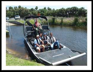
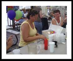
3 Lake Jesup Vegetation Survey July 16-19, 2007 Agencies: Florida Department of Environmental Protection Florida Fish and Wildlife Conservation Commission Seminole County Water Quality Seminole County Sherriff's Office St Johns River Water Management District And Seminole County Public Works GIS Seminole County Environmental Services Providing Boats GPS Units An ArcPad License Biologists GPS Operators And a whole lot of learning and fun!


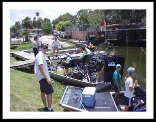
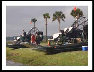
4 Logistics/scheduling by our Lake Management Program Coordinator 5 Teams Agencies bring their boats, biologists County provides GPS units and Operators
5
6 Survey of Shoreline Vegetation Survey of any Underwater Vegetation Survey of Floating Vegetation Questions: Which Shoreline? FEMA FIS Study 2005 shoreline How far inwards into the shoreline? Visible line from boat What species of vegetation are expected to be found? Species List provided How many Transect Sections? About 1000 ft apart


7 Procedure for Shorelines Shorelines sections assigned to a team Sections divided into sub-sections with a pre-assigned ID no. to match Field Book ID. GPS Operator navigates to start of section and calls out end of section. GPS operator records only the dominant vegetation from a domain drop down against the shoreline section ID Biologist records all other species by percentage of coverage of the shoreline section in Field Book. Polylines

8 Procedure for Floating Vegetation Empty polygon feature class Create polygon in field by running the airboat around the edge Assign ID GPS operator records only the dominant vegetation from a domain drop down against the shoreline section ID Biologist records all other species by percentage of coverage of the polygon in Field Book. Polygons


9 Procedure for Transects Boat follows transect line Biologist drops rake Drop a GPS point if underwater vegetation found If polygon is identifiable under water, drop points around perimeter Assign ID GPS operator records only the dominant vegetation from a domain drop down against the shoreline section ID Biologist records all other species in Field Book.
10


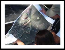
11 90 species domain Had to be re-typed into a table Field Book
12 What really happened I had never used a GPS before Had no ArcPad license The PW GIS team had used data loggers of the antiquated kind No team had an experienced GPS operator either Transect boats needed waypoints to navigate transects via their Garmin I don t like the sun Solution We managed 1 ArcPad license SemCo Environmental Services provided 4 GPS units (one did not work at all) they all had Arc Pad Went through a crash course on GPS from Environmental Services GPS Settings ArcPad Projects Data Dictionary Uploads and merges


13 Then we trained the GPS Operator team Test Run on July 16 GPS files were saved by date and team


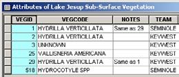
14 The Results All the field book data was entered into a table in the geodatabase
15 Lake Jesup Vegetation Survey May 3-4, 2010 Public Works Traffic Engineering has 2 GPS units Environmental Services has upgraded their GPS units We know what to expect However The shoreline no longer looks the same water is higher There has been a restoration project The Aquatic Habitat Restoration and Enhancement Sub-section (AHRES) is part of the Florida Fish and Wildlife Conservation Commission. Mission is to manage and restore freshwater aquatic habitats to benefit fish and wildlife.

16 Lake Jesup Vegetation Survey May 3-4, 2010 Keep the same shoreline sections, transects Map additional exposed shorelines with new ID


17 Map Analysis for a biologist Native vs Non-Native Species A Native column was added to the Species list

18 Map Analysis for a biologist Restoration Area changes A happy thing!


19 Map Analysis for a biologist Submersed Vegetation changes A happy thing!

20 Map Analysis for a biologist Floating Vegetation changes FLOATING VEGETATION YEAR TOTAL NATIVE NON-NATIVE Number of Polygons surveyed


21 Map Analysis for a biologist Floating Vegetation changes
22 And in the end The 2010 Survey was actually more difficult Biologists noted species not in the GIS domain The GPS Operators did not follow protocol especially along old shoreline sections and assigned their own IDs Satellite reception was particularly spotty Boat went faster than the GPS trace There were a few re-runs An airboat was not used to run the polygons so the polygons were larger than the actual occurrence There was actually additional work and QA/QC back at the office It is difficult to record/represent via maps, ever changing nature at such a small scale Survey of the SR 46 bridge area on 9/28/2010 Try photo interpretation with ArcGIS 10 using field samples
23 Gloria Eby Senior Environmental Scientist Seminole County Water Quality Section Lake Management Program Lakshmi Sankaran Sr GIS Analyst Seminole County Public Works
Aquatic Plant Point-Intercept Survey for Pike Lake, Scott County, Minnesota
 Campers on Pike Lake, Scott County, Minnesota, 2015 Aquatic Plant Point-Intercept Survey for Pike Lake, Scott County, Minnesota [Plant Survey Conducted August 24, 2015] Prepared for: Prior Lake/Spring
Osoyoos Lake Aquatic Plant Mapping
 Osoyoos Lake Aquatic Plant Mapping AquaTechnex, LLC Presented to Okanogan County NWCB by PO Box 30824 Bellingham WA, 98228 www.aquatechnex.com Introductions Myriophyllum spicatum or Eurasian Milfoil has
Aquatic Plant Point-Intercept Survey for Cates Lake, Scott County, Minnesota
 American Lotus in Cates Lake, Scott County, Minnesota, 2016 Aquatic Plant Point-Intercept Survey for Cates Lake, Scott County, Minnesota [Plant Survey Conducted August 29, 2016] Prepared for: Prior Lake-Spring
next trip? Bulrush and fishing areas Discussion of mitigation of ruined areas Better trip agenda (stick to times) or smaller sections/trip
 or smaller sections/trip") Overview Lake Istokpoga Advisory Committee Meeting 4 Bert J. Harris Jr. Agricultural Center, Conference Room 3 4509 George Blvd; Sebring, Florida 33875 December 13, 2018 Summary On Thursday, December 13,
Overview Lake Istokpoga Advisory Committee Meeting 4 Bert J. Harris Jr. Agricultural Center, Conference Room 3 4509 George Blvd; Sebring, Florida 33875 December 13, 2018 Summary On Thursday, December 13,
Survey Technique for Underwater Digital Photography with Integrated GPS Location Data
 Survey Technique for Underwater Digital Photography with Integrated GPS Location Data Tim Siwiec: United States Environmental Protection Agency Abstract This survey technique is an inexpensive method of
Instream Flow Water Rights in the Snake and Salt River Basins. Paul Dey, Wyoming Game and Fish Department
 Instream Flow Water Rights in the Snake and Salt River Basins Paul Dey, Wyoming Game and Fish Department Snake/Salt River Basin Instream Flow Water Rights Basis for instream flow work Segments, quantities,
New two-lane bridge to replace the existing structure spanning the Maple River just south of the Village s central business district
 New two-lane bridge to replace the existing structure spanning the Maple River just south of the Village s central business district Rehabilitate the old bridge Convert to a nonmotorized trail Restore
Eelgrass Survey Reporting Form 2222 Channel Road Newport Beach, CA Eelgrass (Zostera marina) Survey
 Survey") Eelgrass Survey Reporting Form 2222 Channel Road Newport Beach, CA 92660 Eelgrass (Zostera marina) Survey Survey Date: July 19th, 2013 Report Date: July 26 th, 2013 Prepared by: Coastal Resources Management,
Eelgrass Survey Reporting Form 2222 Channel Road Newport Beach, CA 92660 Eelgrass (Zostera marina) Survey Survey Date: July 19th, 2013 Report Date: July 26 th, 2013 Prepared by: Coastal Resources Management,
METHODS PAPER: Downstream Bathymetry and BioBase Analyses of Substrate and Macrophytes
 Mactaquac Aquatic Ecosystem Study Report Series 2015-006 METHODS PAPER: Downstream Bathymetry and BioBase Analyses of Substrate and Macrophytes Ben Wallace, Jae Ogilvie and Wendy Monk 17 February 2015
Analysis Data Sources
 Page Technical Appendix D 1 SMP Analysis Data Sources the set bathymetry levee riprap mine lakebath_arc FloodHazardD ata.mdb\flood HazardZoneCo mponents\fhcl evee FloodHazardD ata.mdb\flood HazardZoneCo
COMMUNITY WATERSHED PROJECT
 SABINE RED RIVER COMMUNITY WATERSHED PROJECT A Watershed Approach to Aquatic Resources Do you have a stake in the water, the wildlife, the use of the land? Help us do for fish what was done for ducks*.
Kasaan to Goose Creek Road Project Project Description U.S. Army Corps of Engineers Permit The following table presents the mile point of the culverte
 Kasaan to Goose Creek Road Project Project Description U.S. Army Corps of Engineers Permit The following table presents the mile point of the culverted open water crossings, name of water crossing if known,
Aquatic Plant Management and Importance to Sport Fisheries
 Aquatic Plant Management and Importance to Sport Fisheries Presentation to Michigan Inland Lakes Convention May 2014 Mike Maceina Professor Emeritus School of Fisheries, Aquaculture, and Aquatic Sciences
Kerr Lake Vegetation Survey. October November Report submitted by NC State University. Background
 Kerr Lake Vegetation Survey October November 2012 Report submitted by NC State University Background Hydrilla (Hydrilla verticillata) is a non-native invasive submersed aquatic plant. This plant was first
Behavior and survival of hatchery reared advanced fingerling largemouth bass using radio telemetry. Brandon Thompson
 Behavior and survival of hatchery reared advanced fingerling largemouth bass using radio telemetry Brandon Thompson Florida largemouth bass Micropterus salmoides floridanus Premier freshwater sportfish
THREATENED, ENDANGERED, AND SENSITIVE SPECIES 2010 ANNUAL REPORT
 LICENSE ARTICLE 410 THREATENED, ENDANGERED, AND SENSITIVE SPECIES 2010 ANNUAL REPORT REPORTING PERIOD JANUARY 1 DECEMBER 31, 2010 BAKER RIVER HYDROELECTRIC PROJECT FERC No. 2150 Puget Sound Energy Bellevue,
Striped Bass and White Hybrid (x) Striped Bass Management and Fishing in Pennsylvania
 Striped Bass Management and Fishing in Pennsylvania") Striped Bass and White Hybrid (x) Striped Bass Management and Fishing in Pennsylvania Prepared by R. Lorantas, D. Kristine and C. Hobbs PFBC Warmwater Unit 2005 (stocking numbers updated after 2005) Goal:
Striped Bass and White Hybrid (x) Striped Bass Management and Fishing in Pennsylvania Prepared by R. Lorantas, D. Kristine and C. Hobbs PFBC Warmwater Unit 2005 (stocking numbers updated after 2005) Goal:
Florida Seagrass Integrated Mapping and Monitoring Program
 Florida Seagrass Integrated Mapping and Monitoring Program - 2004 The following document is composed of excerpts taken from the 2011 publication, Seagrass Integrated Mapping and Monitoring for the State
Susquehanna University and the PFBC Unassessed Waters Initiative in the Susquehanna Basin Jonathan M. Niles Mike Bilger
 and the PFBC Unassessed Waters Initiative in the Susquehanna Basin 2011-2015 Jonathan M. Niles Mike Bilger Pennsylvania Streams All streams of PA have a designated use - Huge resource - 8,011 named tributaries:
Miccosukee Tribe of Indians of Florida. Rory Feeney: Fish and Wildlife Director Gintautas Zavadzkas: Fisheries Biologist
 Miccosukee Tribe of Indians of Florida Rory Feeney: Fish and Wildlife Director Gintautas Zavadzkas: Fisheries Biologist History/Background Priority Animal Species Priority Animals Burmese Python, exotic
Changes in Fish Composition in an Eutrophic, Lacustrine River
 Changes in Fish Composition in an Eutrophic, Lacustrine River Lori McCloud St. Johns River Water Management District Russell Brodie, Florida Fish and Wildlife Conservation Commission Justin Solomon, Florida
Video-Based Mapping of Oyster Bottom in the Upper Piscataqua River, Sturgeon Creek, and Spruce Creek
 University of New Hampshire University of New Hampshire Scholars' Repository PREP Reports & Publications Institute for the Study of Earth, Oceans, and Space (EOS) 1-21-2009 Video-Based Mapping of Oyster
Mud Bay SLELO-PRISM Water Chestnut & Hydrilla Surveillance 2012
 St. Lawrence Eastern Lake Ontario Partnership for Regional Invasive Species Management Mud Bay Water Chestnut & Hydrilla Surveillance 2012 June 27 th (Water Chestnut) & August 2 (Hydrilla), 2012 Figure
Maryland Chapter Trout Unlimited Brook Trout Conservation Effort
 Maryland Chapter Trout Unlimited Brook Trout Conservation Effort Photo by Matt Kline Portfolio of Recent Work MDTU Brook Trout Conservation Coordinator: Scott C. Scarfone, ASLA sscarfone@oasisdesigngroup.com
Pascagoula River Marsh 2017 REEL FACTS Stephen Brown Fisheries Biologist
 Pascagoula River Marsh 217 REEL FACTS Stephen Brown Fisheries Biologist stephenb@mdwfp.state.ms.us General Information: The Pascagoula River marsh is 25 acres of tidal creeks, canals, bays, and streams
Eelgrass Survey PARADISE CAY BELVEDERE, MARIN COUNTY CALIFORNIA. Prepared For:
 Eelgrass Survey PARADISE CAY BELVEDERE, MARIN COUNTY CALIFORNIA Prepared For: Radford (Skid) Hall, Ph.D. Land Planning and Permitting Consultant 500 Airport Blvd., Suite 350 Burlingame, CA 94010 (650)
Eglin Air Force Base, FL
 Determining Marine Movement and Behavior of the Gulf Sturgeon in the Gulf Sturgeon Critical Habitat of the Gulf Testing and Training Range and Santa Rosa Island Complex Bob Miller/J. Mike Nunley /Amanda
Black Sturgeon Regional Plan
 Black Sturgeon Regional Plan This is one of twenty Regional Plans that support implementation of the Lake Superior Biodiversity Conservation Strategy (Strategy). The Strategy, prepared and overseen by
las vegas wash coordination committee
 las vegas wash coordination committee lvwash.org Proposal to Conduct a Small Mammal Study in the Las Vegas Wash, Nevada March 2009 Proposal to Conduct a Small Mammal Study in the Las Vegas Wash, Nevada
Pascagoula River Marsh 2018 REEL FACTS Stephen Brown Fisheries Biologist
 Pascagoula River Marsh 218 REEL FACTS Stephen Brown Fisheries Biologist stephenb@mdwfp.state.ms.us General Information: The Pascagoula River marsh is 25 acres of tidal creeks, canals, bays, and streams
DRAFT TECHNICAL MEMORANDUM
 DRAFT TECHNICAL MEMORANDUM From: File No.: 213.001 Re: Beaux Arts Village Shoreline - 2016 Introduction The Washington Academy of Beaux Arts (WABA) completed shoreline habitat restoration at three locations
1.Mill Creek Watershed Summary Description and Land Use
 1.Mill Creek Watershed Summary Description and Land Use Table xxx: Mill Creek Watershed Overview Watershed Size 31,435 acres/49.1 sq miles/ 127.1 sq km Elevation Range 5,594 feet [4,967-10,561] Stream
Use of Conservation Moorings as a Component of Eelgrass Restoration in two Massachusetts Harbors
 Use of Conservation Moorings as a Component of Eelgrass Restoration in two Massachusetts Harbors Massachusetts Bays Program Division of Marine Fisheries Jay Baker, Tay Evans, Mass Bays Program MarineFisheries
Unit 1 Lesson 2: Reef Surveys and Deep Worker. When Coral Reefs Get in the Way...
 Unit 1 Lesson 2: Reef Surveys and Deep Worker Lesson Objectives: Upon completion of this unit students should gain knowledge and understanding of: factors that cause physical damage to coral reefs the
PROCEDURE FOR MONITORING AN AQUATIC PLANT PROBLEM 1
 PROCEDURE FOR MONITORING AN AQUATIC PLANT PROBLEM 1 The density, diversity, and growth patterns of aquatic plants are unique to each lake. Therefore, many of the details concerning sample site locations
Eurasian Water-milfoil Bed Mapping Survey Red Lake (WBIC: ) Douglas County, Wisconsin
 Douglas County, Wisconsin") Eurasian Water-milfoil Bed Mapping Survey Red Lake (WBIC: 2492100) Douglas County, Wisconsin Red Lake Eurasian water-milfoil with >12 leaflet pairs/limp whorls out of water EWM Beds on Red Lake 10/2/16
Eurasian Water-milfoil Bed Mapping Survey Red Lake (WBIC: 2492100) Douglas County, Wisconsin Red Lake Eurasian water-milfoil with >12 leaflet pairs/limp whorls out of water EWM Beds on Red Lake 10/2/16
2016 Biological Science Technician (Wildlife/Fish) Seasonal Positions
 Seasonal Positions") 2016 Biological Science Technician (Wildlife/Fish) Seasonal Positions USDA Forest Service, R-4 (Intermountain Region) Ashley National Forest, The Ashley National Forest will be filling Seasonal Biological
2016 Biological Science Technician (Wildlife/Fish) Seasonal Positions USDA Forest Service, R-4 (Intermountain Region) Ashley National Forest, The Ashley National Forest will be filling Seasonal Biological
Nalcor Energy Lower Churchill Project, Environmental Effects Monitoring Program 2017 Mealy Mountains Herd (MMH) Caribou
 Caribou") Nalcor Energy Lower Churchill Project, Environmental Effects Monitoring Program 2017 Mealy Mountains Herd (MMH) Caribou 2017 Aerial Survey Prepared for: Nalcor Energy Hydro Place, 500 Columbus Drive P.O.
Nalcor Energy Lower Churchill Project, Environmental Effects Monitoring Program 2017 Mealy Mountains Herd (MMH) Caribou 2017 Aerial Survey Prepared for: Nalcor Energy Hydro Place, 500 Columbus Drive P.O.
Tunica Cutoff 2018 REEL FACTS Keith Meals Fisheries Biologist
 Tunica Cutoff 218 REEL FACTS Keith Meals Fisheries Biologist keithm@mdwfp.state.ms.us General Information: Tunica Cutoff was created by the US Army Corps of Engineers (COE) in 1942 when a bend in the Mississippi
Interagency Special Status/Sensitive Species Program FY2005 Inventory & Conservation Planning Status Report
 Interagency Special Status/Sensitive Species Program FY2005 Inventory & Conservation Planning Status Report PROJECT TITLE: Crooked River National Grassland Pygmy Rabbit Habitat Assessment and Survey PROJECT
LaSalle Park Marina Wave Break
 LaSalle Park Marina Wave Break Federal and Municipal Environmental Assessment Background History of the Marina and LaSalle Park The LaSalle Park Marina is located in LaSalle Park at the foot of LaSalle
FACT SHEET MCGREGOR LAKE RESTORATION HABITAT PROJECT POOL 10, UPPER MISSISSIPPI RIVER, WISCONSIN ENVIRONMENTAL MANAGEMENT PROGRAM
 FACT SHEET MCGREGOR LAKE RESTORATION HABITAT PROJECT POOL 10, UPPER MISSISSIPPI RIVER, WISCONSIN ENVIRONMENTAL MANAGEMENT PROGRAM LOCATION McGregor Lake is located within a mid-river island in Pool 10
FINAL Caples Lake Fisheries Management Plan. Version 4.0
 FINAL Caples Lake Fisheries Management Plan Version 4.0 August 15, 2008 Purpose The Caples Lake Fisheries Management Plan (Plan) outlines the stocking plan to reestablish a sport fishery in Caples Lake
Tips for Using & Printing Spreadsheets
 Key to Spreadsheets Spreadsheet # Type Description/Purpose a Development & Construction in Waterways b Debits Development & Construction in Other Aquatic Areas c Indirect Impacts to Waterways from Development
ATTACHMENT F. Minnesota Department of Natural Resources. Marsh Lake Ecosystem Restoration Project
 ATTACHMENT F Minnesota Department of Natural Resources Marsh Lake Ecosystem Restoration Project Mussel Rescue and Translocation Plan for Pomme de Terre River Restoration (Prepared June, 2016) Attachment
Susitna-Watana Hydroelectric Project Document ARLIS Uniform Cover Page
 Alaska Resources Library & Information Services Document ARLIS Uniform Cover Page Title: Wildlife harvest analysis study, Study plan Section 10.20 : Final study plan SuWa 200 Author(s) Personal: Author(s)
Indiana Administrative Code Page IAC Aquaculture permit Authority: IC Affected: IC Sec. 17. (a) A person must not
 A person must not") Indiana Administrative Code Page 71 312 IAC 9-10-17 Aquaculture permit Affected: IC 14-22-27 Sec. 17. (a) A person must not import, raise, sell, or transport fish into or within Indiana without an aquaculture
Indiana Administrative Code Page 71 312 IAC 9-10-17 Aquaculture permit Affected: IC 14-22-27 Sec. 17. (a) A person must not import, raise, sell, or transport fish into or within Indiana without an aquaculture
2016 Field Survey Oneida Lake / Three Mile Bay WMA SLELO-PRISM Early Detection Surveillance
 St. Lawrence Eastern Lake Ontario Partnership for Regional Invasive Species Management 2016 Field Survey Oneida Lake / Three Mile Bay WMA Early Detection Surveillance August 3 rd, 4 th, 5 th, and 8 th,
Comparison of Acoustic and Aerial Photographic Methods for Quantifying the Distribution of Submersed Aquatic Vegetation in Sagamore Creek, NH
 Comparison of Acoustic and Aerial Photographic Methods for Quantifying the Distribution of Submersed Aquatic Vegetation in Sagamore Creek, NH by Bruce Sabol, Elizabeth Lord, Kevin Reine, and Deborah Shafer
Trout Unlimited and the Kittatinny Ridge Coalition.
 Trout Unlimited and the Kittatinny Ridge Coalition www.tu.org Trout Unlimited TU works to protect, reconnect, restore and sustain North America s coldwater fisheries and their watersheds. We use science
Conservation and Restoration Florida s Coastal Marshes: An Overview of MESS. Jeff Beal, Kent Smith, Erin McDevitt, Maria Merrill
 Conservation and Restoration Florida s Coastal Marshes: An Overview of MESS Jeff Beal, Kent Smith, Erin McDevitt, Maria Merrill FWC s MESS: -Marine/Estuarine Subsection -within Aquatic Habitat Conservation
Quantitative Freshwater Mussel Survey Date Prepared: 11/20/2017
 PARTNERSHIP FOR THE DELAWARE ESTUARY Science Group Quantitative Freshwater Mussel Survey Date Prepared: 11/20/2017 Prepared By: Kurt Cheng Suggested Citation: Cheng, K. 2017. Quantitative Freshwater Mussel
AGENCY/ORGANIZATION OFFICE/DIVISION SECTION/SUBSECTION ACTIONS (Related to Coral Reefs) Natural Resources Planning and Management Division
 Natural Resources Planning and Management Division") AGENCY/ORGANIZATION OFFICE/DIVISION SECTION/SUBSECTION ACTIONS (Related to Coral Reefs) Broward County Environmental Protection and Growth Department Natural Resources Planning and Division Broward County
AGENCY/ORGANIZATION OFFICE/DIVISION SECTION/SUBSECTION ACTIONS (Related to Coral Reefs) Broward County Environmental Protection and Growth Department Natural Resources Planning and Division Broward County
Willamette River Oregon Chub
 Willamette River Oregon Chub Interim Risk Assessment Oregon chub (Oregonichthys crameri), small minnows endemic to the Willamette Valley, were federally listed as endangered under the Endangered Species
Florida DOT Case Study
 Florida DOT Case Study 1 Background In 2013, MetroPlan Orlando became one of the first planning agencies in the world to use Strava Metro data to make better decisions about where to improve bicycle and
located Let s go fishing Hydrilla
 Our Lake of the Month for November is Lake August (set your GPS to 27.2750-81.4136). The elevation of Lake August is 102.5. Lake August is a 52 acre dredge hole lake (man-made from a former wetland; see
MISSISSIPPI MAKEOVER A Plan for Restoration, Just Around the Bend
 MISSISSIPPI MAKEOVER A Plan for Restoration, Just Around the Bend Interim Report Card 2013 Project coordinated by the Dakota County Soil and Water Conservation District and sponsored by the Minnesota Pollution
Estimated on-the-ground start and end dates: 1 June October 2018
 A. Applicant Information Name of Organization: U.S. Army Corps of Engineers, Carlyle Lake 801 Lake Road, Carlyle, IL 62231 Contact Information: Robert Wilkins, Operations Manager, (618) 594-2484, Robert.Wilkins@usace.army.mil
Ross Barnett Reservoir 2019
 Ross Barnett Reservoir 19 Reel Facts Ryan Jones Fisheries Biologist Ryan.Jones@wfp.ms.gov (1) 89-31 General Information: Ross Barnett Reservoir is a 33, acre impoundment of the Pearl River. It consists
SUMMARY REPORT FOR LAKE ST. MALO FISHERIES ASSESSMENT. Prepared for the St. Malo and District Wildlife Association
 SUMMARY REPORT FOR LAKE ST. MALO FISHERIES ASSESSMENT Prepared for the St. Malo and District Wildlife Association Presented by August 25, 2014 Study dates thus far: Date Tasks February 16 Fishing derby;
North Carolina Wildlife Resources Commission Agency Overview. Appropriations Subcommittee on Natural and Economic Resources February 22, 2011
 Agency Overview Appropriations Subcommittee on Natural and Economic Resources February 22, 2011 Agency Background Key Funding Elements Agency Board Economic Impacts Background Agency Purpose derived from
Environmental Review and Permitting for Wild Trout
 Environmental Review and Permitting for Wild Trout Tom Shervinskie Wild Trout Summit Watershed Analysis Section August 26, 2017 Division of Environmental Services The mission of the Pennsylvania Fish and
SKIATOOK LAKE MANAGEMENT PLAN
 SKIATOOK LAKE MANAGEMENT PLAN Background Skiatook Lake impounds Hominy Creek, 5 miles west of Skiatook in Osage County, Oklahoma (Figure 1). Skiatook Lake covers 10,540 surface acres and was constructed
LITTLE WHITE OAK Knox County 2006 Fish Management Report. Debbie King Assistant Fisheries Biologist
 LITTLE WHITE OAK Knox County 2006 Fish Management Report Debbie King Assistant Fisheries Biologist Fisheries Section Indiana Department of Natural Resources Division of Fish and Wildlife I.G.C.-South,
Chateaugay Lakes Milfoil Control Program
 Chateaugay Lakes Milfoil Control Program Summary of Activities and Findings for June August 29 Prepared By: Daniel L. Kelting Executive Director Adirondack Watershed Institute Paul Smith's College P.O.
Admiralty Inlet Pilot Tidal Project FERC No Appendix C. Derelict Gear Monitoring Plan
 Appendix C Derelict Gear Monitoring Plan ADMIRALTY INLET PILOT TIDAL PROJECT FERC PROJECT NO. 12690 DERELICT GEAR MONITORING PLAN (submitted with the Final Application for a New Pilot Project License)
Freshwater Mussel Tagging, Release, and Monitoring Date Prepared: 11/20/2017
 PARTNERSHIP FOR THE DELAWARE ESTUARY Science Group Freshwater Mussel Tagging, Release, and Monitoring Date Prepared: 11/20/2017 Prepared By: Kurt Cheng Suggested Citation: Cheng, K. 2017. Freshwater Mussel
Welcome to Paddle for the Edge!
 Welcome to Paddle for the Edge! Thank you for volunteering to conduct a survey of the Barnegat Bay s shorelines. As a citizen scientist, you become part of a project to collect critical data about current
Ross Barnett Reservoir 2018
 Ross Barnett Reservoir 18 Reel Facts Ryan Jones Fisheries Biologist Ryanj@mdwfp.state.ms.us (61) 89-341 General Information: Ross Barnett Reservoir is a 33, acre impoundment of the Pearl River. It consists
Estimating Summer Steelhead Escapement using Redd Surveys: What have we learned and where do we go? Jim Ruzycki Oregon Department of Fish & Wildlife
 Estimating Summer Steelhead Escapement using Redd Surveys: What have we learned and where do we go? Jim Ruzycki Oregon Department of Fish & Wildlife Spawner Abundance for the John Day Summer Steelhead
Lake Texoma Advisory Committee
 Lake Texoma Authorized by Flood Control Act of 1938 Construction of dam completed in 1944 89,000 surface acres Largest lake in capacity in the Tulsa District Operated by the U.S. Army Corps of Engineers
Table xxx: Listed and Suspected Impairments for Willow Creek 2010 Reach Impairment Pollutant Impaired Uses
 1. (Fairmont) Watershed Summary Description and Land Use Table xxx: (Fairmont) Watershed Overview Watershed Size 18,331 acres/28.7 sq miles/74.3 sq km Elevation Range 2,615 feet [4,980-7,595] Stream Miles
Saskatchewan Adult Invasive Mussel Monitoring (AIMM) Guide
 Guide") Saskatchewan Adult Invasive Mussel Monitoring (AIMM) Guide Background Coordinated by the Government of Saskatchewan s Fish, Wildlife and Lands Branch, the Adult Invasive Mussel Monitoring (AIMM) Program
Saskatchewan Adult Invasive Mussel Monitoring (AIMM) Guide Background Coordinated by the Government of Saskatchewan s Fish, Wildlife and Lands Branch, the Adult Invasive Mussel Monitoring (AIMM) Program
Annual Report for Fiscal Year and Future Plans for the Tillamook Bay Watershed Council
 Annual Report for Fiscal Year 2012-2013 and Future Plans for the Tillamook Bay Watershed Council A report prepared for the Tillamook County Board of Commissioners August 2013 Table of Contents: Recently
STRAVA - DATA ACCESS AND USES. March 9, 2016 Shaun Davis + Dewayne Carver Florida Dept. of Transportation
 STRAVA - DATA ACCESS AND USES March 9, 2016 Shaun Davis + Dewayne Carver Florida Dept. of Transportation AGENDA Training Accessing the Data Data Characteristics Potential Uses Question and Answer WHAT
Wild Virginia and Heartwood first raised this issue at the May 19, 2014 public meeting.
 June 13, 2014 Karen Stevens Pat Sheridan, District Ranger Warm Springs Ranger District 422 Forestry Road Hot Springs, VA 24445 karenlstevens@fs.fed.us psheridan@fs.fed.us re: Lower Cowpasture Restoration
Bathymetry Data Collection for Subaqueous Soil Mapping. Maggie Payne 2 nd National Workshop on Subaqueous Soils Rhode Island August 9-12, 2010
 Bathymetry Data Collection for Subaqueous Soil Mapping Maggie Payne 2 nd National Workshop on Subaqueous Soils Rhode Island August 9-12, 2010 Overview of Method Collect tide data Collect bathymetry data
Pennsylvania s Unassessed Waters Initiative ( )
") Pennsylvania s Unassessed Waters Initiative (2010-2013) Robert Weber PA Fish and Boat Commission Division of Fisheries Management Fisheries Biologist Renae Hodorowicz Western PA Conservancy Watershed Conservation
Pennsylvania s Unassessed Waters Initiative (2010-2013) Robert Weber PA Fish and Boat Commission Division of Fisheries Management Fisheries Biologist Renae Hodorowicz Western PA Conservancy Watershed Conservation
Everything a Lake Should Be
 Everything a Lake Should Be It's not what we do that sets us apart. It's how and why we do it so well. RESPONSIBLE LAKE MANAGEMENT Since 1977, Aquatic Systems has been solving difficult waterway management
Big Spring Creek Habitat Enhancement and Fishery Management Plans
 Big Spring Creek Habitat Enhancement and Fishery Management Plans November 5, 2012 Big Spring Events and Activities Center Newville, PA Charlie McGarrell Regional Habitat Biologist Pennsylvania Fish and
Jason Blackburn, Paul Hvenegaard, Dave Jackson, Tyler Johns, Chad Judd, Scott Seward and Juanna Thompson
 Alberta Conservation Association (ACA) Date: 2014-2015 Project Name: Owl River Walleye and Aquatic Habitat Assessment Fisheries Program Manager: Peter Aku Project Leader: Tyler Johns Primary ACA staff
PRE- PROPOSAL FORM - Lewis River Aquatic Fund
 PRE- PROPOSAL FORM - Lewis River Aquatic Fund 1. Applicant organization. USDA Forest Service Gifford Pinchot National Forest 2. Organization purpose Resource management agency 3. Project manager (name,
R & E Grant Application 13 Biennium
 R & E Grant Application 13 Biennium Project #: 13-090 Project Information R&E Project Request: Match Funding: Total Project: Start Date: End Date: Project Email: Project Biennium: Organization: Applicant
Free fish and invertebrate ID classes gets SCUBA divers involved in marine conservation
 Proceedings of the 2007 Georgia Basin Puget Sound Research Conference, Vancouver, BC pg. 1 Free fish and invertebrate ID classes gets SCUBA divers involved in marine conservation Janna Nichols, Anne Stoltz,
2010 Wildlife Management Unit 501 moose and deer
 2010 Wildlife Management Unit 501 moose and deer Section Authors: Barb Maile and Velma Hudson Suggested Citation: Maile, B., and V. Hudson. 2010. Wildlife Management Unit 501 moose and deer. Pages 73 77.
Site Tour, August 24, Fish Science - Big Lake Coho Salmon Migration and Habitat Use
 Matanuska-Susitna Basin Salmon Habitat Partnership Site Tour, August 24, 2015 Part 1 of Tour Big Lake watershed Fish Science - Big Lake Coho Salmon Migration and Habitat Use Presenter: Jon Gerken (U.S.
Aquatic Biological Assessment. Lassen 15 Restoration Project. Modoc National Forest Warner Mountain Ranger District
 Aquatic Biological Assessment Lassen 15 Restoration Project Modoc National Forest Warner Mountain Ranger District Prepared By:_/s/ Marty Yamagiwa Date: December 10, 2015 Marty Yamagiwa, Natural Resources
PRODUCING A TROPHY LARGEMOUTH BASS FISHERY (CASE STUDY) Greg Grimes President of Aquatic Environmental Services, Inc.
 Greg Grimes President of Aquatic Environmental Services, Inc.") PRODUCING A TROPHY LARGEMOUTH BASS FISHERY (CASE STUDY) Greg Grimes President of Aquatic Environmental Services, Inc. Background 32 acre lake in Harris County, Georgia o The construction of the lake began
PRODUCING A TROPHY LARGEMOUTH BASS FISHERY (CASE STUDY) Greg Grimes President of Aquatic Environmental Services, Inc. Background 32 acre lake in Harris County, Georgia o The construction of the lake began
Table 1. Physical Characteristics of Your Lake.
 The lake assessments are created in partnership with Hillsborough County and the Florida Center for Community Design and Research LAKE ASSESSMENT DOCUMENT White Trout Lake /8/98 Watershed: Sweetwater Creek
Update on Sediment Assessment
 Florida s Mercury TMDL Project Update on Sediment Assessment Lori Balinsky, Paul Blair, Keith Davie, Mike Eckles, Peter Folland, Chris Green, Shannon Gerardi, Pam Novak and Tom Seal Florida DEP Watershed
U.S. Army Corps of Engineers (USACE) P.O. Box 428 Smithville, MO
 P.O. Box 428 Smithville, MO") Applicant Information United States Army Corps of Engineers Kansas City District Principal Contact: Derek Dorsey, Natural Resource Manager U.S. Army Corps of Engineers P.O. Box 428 Smithville, MO 64089
Applicant Information United States Army Corps of Engineers Kansas City District Principal Contact: Derek Dorsey, Natural Resource Manager U.S. Army Corps of Engineers P.O. Box 428 Smithville, MO 64089
Teton County Related Hunting and Fishing Spending, For the Wyoming Wildlife Federation. David T. Taylor & Thomas Foulke
 Teton County Related Hunting and Fishing Spending, 2015 For the Wyoming Wildlife Federation University of Wyoming, Department of Agricultural & Applied Economics David T. Taylor & Thomas Foulke 1 February
Highly Migratory Species Essential Fish Habitat (EFH) Overlay February 27, 2015
 Overlay February 27, 2015") Highly Migratory Species Essential Fish Habitat (EFH) Overlay February 27, 2015 Prepared for: Northeast Regional Ocean Council (NROC) Northeast Ocean Data www.northeastoceandata.org Prepared by: Rachel
Highly Migratory Species Essential Fish Habitat (EFH) Overlay February 27, 2015 Prepared for: Northeast Regional Ocean Council (NROC) Northeast Ocean Data www.northeastoceandata.org Prepared by: Rachel
Creek Trash Assessment (CTA) Methodology (Demonstration: Mill Run Creek, Cheltenham, Pa.)
 Methodology (Demonstration: Mill Run Creek, Cheltenham, Pa.)") Creek Trash Assessment (CTA) Methodology (Demonstration: Mill Run Creek, Cheltenham, Pa.) Mill Run Creek emerges from a storm sewer in Philadelphia to an open creek in Cheltenham. The Creek downstream
Creek Trash Assessment (CTA) Methodology (Demonstration: Mill Run Creek, Cheltenham, Pa.) Mill Run Creek emerges from a storm sewer in Philadelphia to an open creek in Cheltenham. The Creek downstream
Deep-sea corals of the USA: Surveys, maps, & models for exploration and management
 Deep-sea corals of the USA: Surveys, maps, & models for exploration and management Heather Coleman Robert McGuinn Tom Hourigan Peter Etnoyer Matt Dornback Daniel Wagner Dan Dorfman Renee King Deep Sea
Annual Meeting and Director Elections
 Annual Meeting and Director Elections 6:00 p.m. Reception 6:30 p.m. Annual Meeting & Election 1 vacant seat on 5- member board 4-year term Candidate: Scott Hanshue Meet the Candidate Scott Hanshue: Scott
Great Lakes Coastal Wetland Communities: Vulnerabilities to Climate Change and Response to Adaptation Strategies
 Great Lakes Coastal Wetland Communities: Vulnerabilities to Climate Change and Response to Adaptation Strategies CCAF Wetlands Study Investigators: Susan Doka Fisheries & Oceans, Great Lakes Lab for Fisheries
Another essential characteristic of boat channel geography is the form and spacing of channel
 Another essential characteristic of boat channel geography is the form and spacing of channel segments.some channels are simple, and others are complex. The channel systems include: finger canals or basins;
CENTRAL PROJECT: PLANNING EVERGLADES CENTRAL EVERGLADES RESTORING THE HEART OF THE EVERGLADES
 CENTRAL EVERGLADES PLANNING PROJECT: PRESENTED BY Gina Paduano Ralph, Ph.D. U.S. Army Corps of Engineers Jacksonville District Guy Carpenter Florida Fish and Wildlife Conservation Commission APRIL 2014
Good Mooring to You! Jensen Beach Mooring Field. Kathy Fitzpatrick, P.E. Coastal Engineer, Martin County
 Good Mooring to You! Kathy Fitzpatrick, P.E. Coastal Engineer, Martin County Penny Cutt Regional Manager, Coastal Systems International Mooring Field Advantages Provide a safe and secure anchorage at a