Eurasian Water-milfoil Bed Mapping Survey Red Lake (WBIC: ) Douglas County, Wisconsin
|
|
|
- Miranda Hoover
- 5 years ago
- Views:
Transcription
 Douglas County, Wisconsin Red Lake")


1 Eurasian Water-milfoil Bed Mapping Survey Red Lake (WBIC: ) Douglas County, Wisconsin Red Lake Eurasian water-milfoil with >12 leaflet pairs/limp whorls out of water EWM Beds on Red Lake 10/2/16 Project Initiated by: The Red Lake Association and the Wisconsin Department of Natural Resources * Red Lake Canopied EWM on Red Lake s eastern flat 10/2/16 Survey Conducted by and Report Prepared by: Endangered Resource Services, LLC Matthew S. Berg, Research Biologist St. Croix Falls, Wisconsin October 2, 2016
2 TABLE OF CONTENTS LIST OF FIGURES AND TABLES.. Page ii INTRODUCTION METHODS RESULTS Fall Eurasian Water-milfoil Bed Mapping.. 3 Descriptions of EWM Beds... 4 DISCUSSION AND CONSIDERATIONS FOR MANAGEMENT LITERATURE CITED... 9 APPENDIX I: Fall 2016 Eurasian Water-milfoil Bed Map i
3 LIST OF FIGURES AND TABLES Page # Figure 1: Red Lake Bathymetric Map... 1 Figure 2: Rake Fullness Ratings.. 2 Figure 3: 2016 Fall EWM Bed Mapping Survey Transects Figure 4: 2016 Fall EWM Bed Map EWM Plant from Bed Figure 5: Typical EWM Density in Bed 7 East Midlake Flat Table 1: Fall Eurasian Water-milfoil Bed mapping Summary Red Lake, Douglas County October 2, Figure 6: EWM and Northern Water-milfoil Identification Figure 7: Limp Nature of EWM Leaflets along Stem Stiff Nature of NWM Leaflets along Stem and Overwintering Turions October ii
4 INTRODUCTION: Red Lake (WBIC ) is a 253 acre stratified seepage lake located in the Town of Wascott in south-central/southeastern Douglas County (T43N R11W S21, 28, 29, 32). The lake reaches a maximum depth of 37ft in the deep hole on the south end of the central basin and has an average depth of 11ft (WDNR 2009). Red Lake is mesotrophic in nature and water clarity is good with Secchi readings averaging 10.9ft from and 11.5ft in 2016 (WDNR 2016). This produced a littoral zone that extended to at least 20ft in the fall of The shoreline is dominated by sand with most areas transitioning to sandy muck at depths beyond 10ft. The lake s only nutrient rich organic muck occurs in areas adjacent to the tamarack bogs near the small bay in the far southeast corner and on the north and south ends of the northeast bay (Holt et al. 1973) (Figure 1). Figure 1: Red Lake Bathymetric Map On July 25, 2013, at the request of the Red Lake Association (RLA) and the Wisconsin Department of Natural Resources (WDNR), we conducted the original warm-water pointintercept survey of all aquatic plants in Red Lake. This extensive study established baseline data on the richness, diversity, abundance, and distribution of the lake s aquatic plant populations. At that time, we also found no evidence of Eurasian water-milfoil (Myriophyllum spicatum) (EWM), an invasive exotic aquatic plant, anywhere in the lake. Unfortunately, in July 2016, biologists from the Great Lakes Indian Fish & Wildlife Commission (GLIFWC) found a few EWM plants near the public boat landing on the lake s southwest side and near the Red Lake Resort in the northeast bay. A follow-up survey by WDNR also found plants in these areas. In order to quantify the level of infestation, the WDNR and RLA requested that we systematically search the lake and, if possible, rake remove any EWM found. This report is the summary analysis of that survey conducted on October 2,
5 METHODS: Fall Eurasian Water-milfoil Bed Mapping: We searched the visible littoral zone of the lake in overlapping visual transects and mapped all known beds of EWM. A bed was determined to be any place where we visually estimated that EWM made up >50% of the area s plants and was generally continuous with clearly defined borders. After we located a bed, we motored around the perimeter of the area; took GPS coordinates at regular intervals; estimated the rake range and mean rake fullness rating of EWM within the bed (Figure 2); recorded the depth range and mean depth EWM was growing at, and noted whether it was canopied or not. Using the WDNR s Forestry Tool s Extension to ArcGIS 9.3.1, we then generated bed shapefiles with these coordinates and determined the acreage to the nearest hundredth of an acre. As this was a new infestation, we also marked and attempted to rake remove any individual plants found outside the beds as they were generally few in number. Figure 2: Rake Fullness Ratings 2

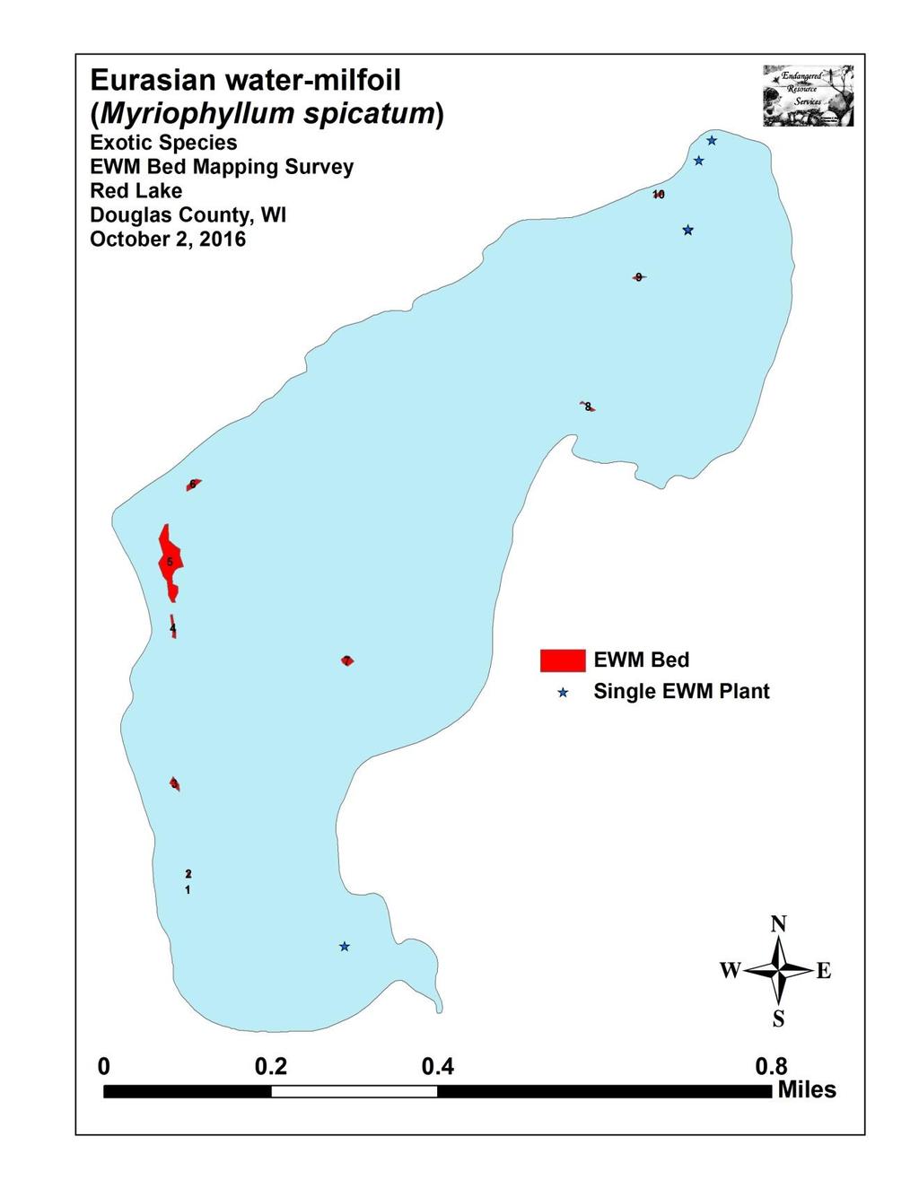
6 RESULTS: Fall Eurasian Water-milfoil Bed Mapping: During the survey, we had bright overhead sun, and winds were calm or nearly calm making for excellent survey conditions as it allowed us to easily find canopied beds. Overall clarity, however, was only fair as the water was somewhat milking, and we could only see the bottom clearly in 5-7ft meaning short plants in deep water may have gone unnoticed. In total, we searched over 34km (21 miles) of transects within Red Lake s visible littoral zone (Figure 3). Figure 3: 2016 Fall EWM Bed Mapping Survey Transects Along these transects, we located and mapped ten Eurasian water-milfoil beds ranging in size from <0.01 acre (Beds 1 and 2) to 0.83 acre (Bed 5) (Figure 4) (Appendix I). In total, these beds covered 1.18 acres or approximately 0.45% of the lake s surface area (Table 1). The vast majority of plants in Beds 1-7 were established in 8-11ft over sandy muck on the outer edge of the rooted littoral zone. At least early on in the infestation, this appeared to be the ecological niche where EWM had a significant competitive advantage and was having the easiest time establishing. Once well-established, as in Beds 4 and 5, EWM continued to expand inward as we documented it in increasingly shallow waters down to 4ft deep in these areas. In the northeastern bay where there were extensive native plant beds, Eurasian watermilfoil was much less common. It is possible EWM was having a harder time establishing in this more competitive environment, but it also may have simply been that these were early pioneer plants and there hadn t been enough time for them to expand beyond the few micro-beds and satellite plants we found. 3

 were found in up to 20ft, but they lack roots and tend to lie flat along the bottom in this type of deep water habitat).")
7 Figure 4: 2016 Fall EWM Bed Map EWM Plant from Bed 5 Descriptions of EWM Beds: Beds 1, 2 and 3 Although the shoreline and associated shallow sand flats along the western shoreline meander back and forth, the drop-off into 10ft+ tends to be rather sudden and is much more linear from north to south. Along this edge in 8-11ft of water, we found three small beds of EWM growing in a relatively narrow band to the edge of the rooted plant littoral zone (Coontail (Ceratophyllum demersum) and Nitella (Nitella flexilis) were found in up to 20ft, but they lack roots and tend to lie flat along the bottom in this type of deep water habitat). Interestingly, Common loons (Gavia immer) were seen foraging around each of these beds. As in other lakes with low levels of EWM, we ve learned that loons can be reliable help in finding small beds of EWM in deep water as the vertical structure EWM provides tends to hold bait fish which the loons key in on. Bed 4 Although most of this bed s EWM was growing along the 8-10ft contour ring, plants were spreading inward toward the shallows, and we found regular scattered towers in as little as 4ft of water. Located directly south of Bed 5, these two areas were almost connected, and, because of this, we expect pioneer sprouts will eventually grow to merge them into one large bed if left unchecked. Bed 5 We found this bed to be by far the worst area on the lake. At its core on the north end, EWM formed a solid canopied mat in 8-11ft, was full of prop-clipped plants, and was becoming an impairment to navigation that forced boaters to go around rather than through. Although the canopied bed ended abruptly on the outer edge, similar to Bed 4, scattered towers were found spreading into the shallow flats to the west. 4
8 Bed 6 This appeared to be the youngest deep-water bed in the lake as the overall mean density was low and plants were often difficult to locate as most of them were at least 3-4ft below the surface. Raking around the perimeter revealed that there were other short new pioneer plants just beyond what we can see. This raised the possibility and perhaps likelihood that there are additional plants/micro-beds that are just out of view along the 8-11ft bathymetric ring between Beds 4, 5, and 6. Bed 7 This bed was the second worst area on the lake in term of both size and density. Canopied at its core in 9ft of water (Figure 5), several plants had been prop-clipped, and, with an abundance of similar habitat in the broad eastern flat of the lake, we believe this bed has to potential to expand rapidly in Figure 5: Typical EWM Density in Bed 7 East Midlake Flat Beds 8, 9 and 10 These three micro-beds occurred in the northeast bay in generally shallow water from 5-7ft deep. Each was more of a cluster of EWM towers than a solid bed. In general, most plants were only a couple of feet tall and had not canopied, contained one or just a few stems, and had a poorly developed root system. All of these factors suggested to us they were likely recent pioneer plants. Because of this presumed recency, and because we saw many floating EWM fragments that had been blown into this bay by the prevailing southwest winds, it is possible, and perhaps likely that many more EWM sprouts will appear here by spring
9 Bed Number 2016 Area in Acres Table 1: Fall Eurasian Water-milfoil Bed Mapping Summary Red Lake, Douglas County October 2, 2016 Canopied Depth Range and Mean Depth (ft) Rake Range and Mean Rake Fullness Field Notes 1 <0.01 Near 9-11; ; 2 EWM about 2ft below surface 2 <0.01 Near 8-10; 9 1-3; 1 EWM about 2ft below surface; majority in 9ft Near 8-10; 9 1-3; 1 EWM about 2ft below surface; majority in 9ft Near 4-10; 9 2-3; 2 Scattered inner border becoming dense in 8-10ft Yes 4-11; 9 <1-3; 2 Worst area; highest density on north end of bed Near 9-11; 10 <1-3; 1 Most EWM 3-4ft below surface; plants 6-7ft tall Yes 8-10; 9 1-3; 2 Small dense bed canopied at core in 9ft Near 5-7; 6 <<1-1; 1 EWM 2ft below the surface no assoc. deep bed Near 5-7; 6 <<1-1; 1 Scattered towers no associated deep bed Near 5-7; 6 <<1-2; 1 Most EWM 2-3ft below the surface Total


10 DISCUSSION AND CONSIDERATIONS FOR MANAGEMENT: Eurasian water-milfoil is well-established in Red Lake making eradication an unrealistic expectation. With this in mind, controlling its spread in the most cost effective manner possible while simultaneously minimizing its impact on the lake s aquatic ecosystem will likely be the lake association s primary goal moving forward. To meet this goal in the short term, we believe that some form of management is warranted in early If chemical treatment is decided upon, one of the challenges will be that most EWM is established in 8-11ft of water and immediately adjacent to areas that routinely plunge to over 20ft making dilution a significant concern. How to best manage these conditions will require a group discussion between the WDNR, the lake association, and a potential applicator. Also complicating control is the fact that Red Lake has a significant amount of the very similar looking Northern water milfoil (Myriophyllum sibiricum) a valuable native plant that provides important fish habitat and is likely to be heavily impacted by chemical treatment. NWM is widely distributed throughout the lake s rooted littoral zone, but does best over sandy and organic muck. Despite its superficial resemblance to EWM, Northern water milfoil can be told apart by its leaflets numbering <24 that are usually held rigidly at 90 degree angles off the stem when out of water. Conversely, EWM normally has >26 leaflets that fall limp against the stem when out of water (Figure 6). EWM also tends to have a bright red growth tip on the top of the plant whereas NWM has a bright lime green growth tip. NWM on Red Lake is often mixed with other plants, is seldom bed-forming, and rarely canopies on the surface; whereas EWM was often found in nearly monotypic beds that excluded most native species and canopied even in deep water. In the fall, NWM also forms winter buds on the tips of shoots whereas EWM has none. These buds were readily visible during the October survey (Figure 7). Eurasian water milfoil Northern water milfoil Figure 6: EWM and Northern Water-milfoil Identification (Berg 2007) 7


11 Figure 7: Limp Nature of EWM Leaflets along Stem Stiff Nature of NWM Leaflets along Stem and Overwintering Turions October 2016 Although EWM currently occupies only a small percentage of the lake s surface area and is much less common than NWM, the results of our survey suggest it is spreading rapidly. Based on the number of beds already established as well as the number of floating fragments we observed on the lake, we believe it is likely that even more EWM will be found during the 2017 growing season. Based on this expectation, we encourage all residents on Red Lake to be on the lookout for new beds and promptly contact us (saintcroixdfly@gmail.com and/or ) with a picture, specimen, description of, and/or preferably GPS coordinates of anything they find that looks suspicious. These locations could then be added to the existing map for management consideration. 8
12 LITERATURE CITED Holt, C, C. Busch, K. Cable, and L. Sather. [online] Red Lake Bathymetric Map. (2016, October). WDNR. [online] Wisconsin Lake Citizen Monitoring Data for Red Lake - Douglas County. Available (2016, October). 9
13 Appendix I: Fall 2016 Eurasian Water-milfoil Bed Map 10
14 11
Eurasian water-milfoil (Myriophyllum spicatum) SCUBA Dive Monitoring Survey Sand Bar Lake WBIC: Bayfield County, Wisconsin
 SCUBA Dive Monitoring Survey Sand Bar Lake WBIC: Bayfield County, Wisconsin") Eurasian water-milfoil (Myriophyllum spicatum) SCUBA Dive Monitoring Survey Sand Bar Lake WBIC: 2494900 Bayfield County, Wisconsin 6ft EWM Towers with Rooted Branch Preparing to Fall Off (Berg 2016) EWM
Eurasian water-milfoil (Myriophyllum spicatum) SCUBA Dive Monitoring Survey Sand Bar Lake WBIC: 2494900 Bayfield County, Wisconsin 6ft EWM Towers with Rooted Branch Preparing to Fall Off (Berg 2016) EWM
Aquatic Plant Point-Intercept Survey for Pike Lake, Scott County, Minnesota
 Campers on Pike Lake, Scott County, Minnesota, 2015 Aquatic Plant Point-Intercept Survey for Pike Lake, Scott County, Minnesota [Plant Survey Conducted August 24, 2015] Prepared for: Prior Lake/Spring
Aquatic Plant Point-Intercept Survey for Cates Lake, Scott County, Minnesota
 American Lotus in Cates Lake, Scott County, Minnesota, 2016 Aquatic Plant Point-Intercept Survey for Cates Lake, Scott County, Minnesota [Plant Survey Conducted August 29, 2016] Prepared for: Prior Lake-Spring
Chateaugay Lakes Milfoil Control Program
 Chateaugay Lakes Milfoil Control Program Summary of Activities and Findings for June August 29 Prepared By: Daniel L. Kelting Executive Director Adirondack Watershed Institute Paul Smith's College P.O.
Management of Hybrid Watermilfoil (Myriophyllum sibericum x spicatum) using Diver Assisted Suction Harvesting
 using Diver Assisted Suction Harvesting") 2527 Lake Ottawa Road Iron River, MI 49935 906.284.2198 Management of Hybrid Watermilfoil (Myriophyllum sibericum x spicatum) using Diver Assisted Suction Harvesting Lake Ellwood, Florence, WI - 2014 Final
2527 Lake Ottawa Road Iron River, MI 49935 906.284.2198 Management of Hybrid Watermilfoil (Myriophyllum sibericum x spicatum) using Diver Assisted Suction Harvesting Lake Ellwood, Florence, WI - 2014 Final
Osoyoos Lake Aquatic Plant Mapping
 Osoyoos Lake Aquatic Plant Mapping AquaTechnex, LLC Presented to Okanogan County NWCB by PO Box 30824 Bellingham WA, 98228 www.aquatechnex.com Introductions Myriophyllum spicatum or Eurasian Milfoil has
Aquatic Plants of the Three Lakes
 Aquatic Plants of the Three Lakes Chris Doyle, CLM Senior Aquatic Biologist/Water Quality Program Supervisor Allied Biological, Inc. 580 Rockport Road Hackettstown, NJ 07840 Phone: 908-850-0303 E-mail:
Summary of Diver Assisted Suction Harvesting Efforts. Lake Ellwood Florence County, WI
 2527 Lake Ottawa Road Iron River, MI 49935 906.284.2198 Summary of Diver Assisted Suction Harvesting Efforts Lake Ellwood Florence County, WI 2015 WDNR Mechanical Harvesting Permit Annual Report Permit
located Let s go fishing Hydrilla
 Our Lake of the Month for November is Lake August (set your GPS to 27.2750-81.4136). The elevation of Lake August is 102.5. Lake August is a 52 acre dredge hole lake (man-made from a former wetland; see
Starry Stonewort in Silver Lake Washington County, WI BRAD STECKART AIS COORDINATOR FOR WASHINGTON AND WAUKESHA COUNTIES
 Starry Stonewort in Silver Lake Washington County, WI BRAD STECKART AIS COORDINATOR FOR WASHINGTON AND WAUKESHA COUNTIES Brad Steckart -AIS coordinator for Washington and Waukesha Counties -Graduated from
Kerr Lake Vegetation Survey. October November Report submitted by NC State University. Background
 Kerr Lake Vegetation Survey October November 2012 Report submitted by NC State University Background Hydrilla (Hydrilla verticillata) is a non-native invasive submersed aquatic plant. This plant was first
Mud Bay SLELO-PRISM Water Chestnut & Hydrilla Surveillance 2012
 St. Lawrence Eastern Lake Ontario Partnership for Regional Invasive Species Management Mud Bay Water Chestnut & Hydrilla Surveillance 2012 June 27 th (Water Chestnut) & August 2 (Hydrilla), 2012 Figure
2015 Macrophyte Survey Results
 Invasive Macrophyte Survey Pilot 2015 2015 Macrophyte Survey Results COMPLETED WITH SUPPORT FROM: Acknowledgments The Invasive Plant Monitoring Program was made possible through the support of Alberta
MEMORANDUM Comfort Lake-Forest Lake Watershed District
 MEMORANDUM Comfort Lake-Forest Lake Watershed District To: Board of Managers Date: December 7, 2016 From: Mike Kinney Subject: 2016 Watercraft Inspections and AIS Report Summaries Watercraft Inspection
EcoLogic Memorandum. TO: Ben Brezell; EDR FROM: Mark Arrigo RE: Possible Impacts of Dredging Snooks Pond DATE: 6/4/07
 EcoLogic Memorandum TO: Ben Brezell; EDR FROM: Mark Arrigo RE: Possible Impacts of Dredging Snooks Pond DATE: 6/4/07 Background EDR P.C. (EDR) has been contracted by a landowner to assess the feasibility
LAKE JESUP VEGETATION MAPPING: AN INTER-AGENCY COLLABORATION. Lakshmi Sankaran, GISP Public Works Department, Seminole County
 LAKE JESUP VEGETATION MAPPING: AN INTER-AGENCY COLLABORATION Lakshmi Sankaran, GISP Public Works Department, Seminole County LAKE JESUP Area - 12 sq miles Shoreline - 53 miles Watershed - 136 sq miles
BIG MARINE LAKE, WASHINGTON COUNTY: 2017 AQUATIC VEGETATION REPORT
 BIG MARINE LAKE, WASHINGTON COUNTY: 2017 AQUATIC VEGETATION REPORT Report by the Invasive Species Program Division of Ecological and Water Resources Minnesota Department of Natural Resources Lake: Big
LAKE PLEASANT Steuben County 2006 Fish Management Report. Larry A. Koza Assistant Fisheries Biologist
 LAKE PLEASANT Steuben County 2006 Fish Management Report Larry A. Koza Assistant Fisheries Biologist Fisheries Section Indiana Department of Natural Resources Division of Fish and Wildlife I.G.C.-South,
2014 Threatened and Endangered Fish Survey of. East Loon Lake and West Loon Lake. Lake County, Illinois
 2014 Threatened and Endangered Fish Survey of East Loon Lake and West Loon Lake Lake County, Illinois Prepared by Integrated Lakes Management 120 LeBaron St. Waukegan, IL 60085. Chris Ryan Chris Rysso
Current Status and Management Recommendations for the Fishery in the Cloverleaf Chain of Lakes
 Current Status and Management Recommendations for the Fishery in the Cloverleaf Chain of Lakes Jason Breeggemann Senior Fisheries Biologist Wisconsin Department of Natural Resources Outline DNR fisheries
CORRESPONDENCE/MEMORANDUM
 CORRESPONDENCE/MEMORANDUM State of Wisconsin DATE: November 13, 2012 FILE REF: [Click here and type file ref.] TO: FROM: Mike Donofrio Harpt Lake File Steve Hogler SUBJECT: 2012 Harpt Lake Electrofishing
Cedar Lake Comprehensive Survey Report Steve Hogler and Steve Surendonk WDNR-Mishicot
 Cedar Lake- 2006 Comprehensive Survey Report Steve Hogler and Steve Surendonk WDNR-Mishicot ABSTRACT Cedar Lake is a 142 acre lake located in the southwest corner of Manitowoc County. It is a seepage lake
Leech Lake Update 5/20/2009 Walker Area Fisheries Office State Hwy. 371 NW Walker, MN
 Frequency (N) Leech Lake Update 5/20/2009 Walker Area Fisheries Office 07316 State Hwy. 371 NW Walker, MN 56484 218-547-1683 Greetings! This update is part of a series of reports the Minnesota Department
Starry Stonewort (Nitellopsis obtusa) Removal Using Diver Assisted Suction Harvesting
 Removal Using Diver Assisted Suction Harvesting") Starry Stonewort (Nitellopsis obtusa) Removal Using Diver Assisted Suction Harvesting Silver Lake, Washington County, WI Brad Steckart, Aquatic Invasive Species Coordinator for Washington and Waukesha
Starry Stonewort (Nitellopsis obtusa) Removal Using Diver Assisted Suction Harvesting Silver Lake, Washington County, WI Brad Steckart, Aquatic Invasive Species Coordinator for Washington and Waukesha
Lake information report
 Page of 5 Lake information report Name: Whitewater Nearest Town: Hoyt Lakes Primary County: St. Louis Survey Date: 08/3/2007 Inventory Number: 69037600 Public Access Information Ownership Type Description
Fish Community and Aquatic Ecosystem Responses to the Cessation of Eurasian Watermilfoil Chemical Treatment on Lake Ellwood, Wisconsin
 Fish Community and Aquatic Ecosystem Responses to the Cessation of Eurasian Watermilfoil Chemical Treatment on Lake Ellwood, Wisconsin Greg G. Sass Wisconsin Department of Natural Resources Fisheries and
SKIATOOK LAKE MANAGEMENT PLAN
 SKIATOOK LAKE MANAGEMENT PLAN Background Skiatook Lake impounds Hominy Creek, 5 miles west of Skiatook in Osage County, Oklahoma (Figure 1). Skiatook Lake covers 10,540 surface acres and was constructed
Aquatic Plant Surveys in Donner Lake State Park, California: Report to California State Parks. Final Draft
 Aquatic Plant Surveys in Donner Lake State Park, California: 2017 Report to California State Parks Final Draft Brant Allen, Katie Senft, and Brandon Berry UC Davis Tahoe Environmental Research Center February
Citizen Lake Monitoring Network. Lakes Convention April 2011 Laura Herman Brenda Nordin Jay Schiefelbein
 Citizen Lake Monitoring Network Lakes Convention April 2011 Laura Herman Brenda Nordin Jay Schiefelbein Wisconsin s Lakes are Changing Faster than Ever: Algae blooms (phosphorus pollution) Destruction
Fisheries Survey of Saratoga Lake
 Fisheries Survey of Saratoga Lake 7- Mark D. Cornwell Kevin Poole State University of New York College of Agriculture & Technology Department of Fisheries & Wildlife Cobleskill, NY ABSTRACT: This survey
DRAFT AMENDMENT 1. Introduction
 DRAFT AMENDMENT 1 Aquatic Plant Management Plan, Yahara River and Upper Mud Lake, Lower Rock River Basin, Dane County Wisconsin Approved by the Dane County Lakes and Watershed Commission on and by the
NEVADA DEPARTMENT OF WILDLIFE STATEWIDE FISHERIES MANAGEMENT
 NEVADA DEPARTMENT OF WILDLIFE STATEWIDE FISHERIES MANAGEMENT FEDERAL AID JOB PROGRESS REPORTS F-20-52 2016 BOULDER RESERVOIR WESTERN REGION NEVADA DEPARTMENT OF WILDLIFE, FISHERIES DIVISION ANNUAL PROGRESS
Aquatic Plant Management and Importance to Sport Fisheries
 Aquatic Plant Management and Importance to Sport Fisheries Presentation to Michigan Inland Lakes Convention May 2014 Mike Maceina Professor Emeritus School of Fisheries, Aquaculture, and Aquatic Sciences
Phase II Final Report Port Canaveral Lionfish Project
 Phase II Final Report Port Canaveral Lionfish Project Contract PO # P14685 Report prepared for Carol Noble Director, Environmental Plans and Programs Canaveral Port Authority Suite 301 445 Challenger Road
MARTINDALE POND Wayne County 2004 Fish Management Report. Christopher C. Long Assistant Fisheries Biologist
 MARTINDALE POND Wayne County 2004 Fish Management Report Christopher C. Long Assistant Fisheries Biologist Fisheries Section Indiana Department of Natural Resources Division of Fish and Wildlife I.G.C.
Eurasian Water-milfoil
 Eurasian Water-milfoil Exotic Eurasian Water-milfoil 11 Native Species of Water-milfoil in USA 7 Native Species of Water-milfoil in WI EWM Native to Asia and Europe EWM Arrived in US in 1942 & WI in 1960s
MaxDepth Aquatics, Inc.
 MaxDepth Aquatics, Inc. Hydroacoustic Survey and Point Sampling of Macrophytes In Diamond Lake 2009 A Report to the Partners for Umpqua Rivers Roseburg, OR And the Umpqua National Forest Roseburg, OR By
Michigan Department of Natural Resources Status of the Fishery Resource Report Page 1
 Michigan Department of Natural Resources 2007-33 Status of the Fishery Resource Report Page 1 Grand Sable Lake Alger County, T49N, R14W, Sec. Many Lake Superior watershed, last year surveyed 2004 James
Chagrin River TMDL Appendices. Appendix F
 Appendix F The following are excerpts from the Eastern Brook Trout Joint Venture s Conservation Strategy (Working Draft v.6), Conserving the Eastern Brook Trout: Strategies for Action Found at: http://www.easternbrooktrout.org/constrategy.html
Summary of and Initial Response to public comments on MN Department of Natural Resources proposal to manage new waters for Muskellunge
 Summary of and Initial Response to public comments on MN Department of Natural Resources proposal to manage new waters for Muskellunge Summary of and Initial Response to public comments: This document
Beaver Creek Reserve Meets Success In 6-County AIS Prevention Effort. Anna Mares Beaver Creek Reserve April 13 th, 2011
 Beaver Creek Reserve Meets Success In 6-County AIS Prevention Effort Anna Mares Beaver Creek Reserve April 13 th, 2011 Outline Beaver Creek Reserve Five-county AIS Survey of Lakes With Public Access in
Aquatic Invasive Species : Update on AIS related efforts at Deep Creek Lake, Maryland
 Aquatic Invasive Species : Update on AIS related efforts at Deep Creek Lake, Maryland Presentation to the DCL Property Owners Association August 19, 2017 Julie Bortz Maryland Department of Natural Resources
ATTACHMENT F. Minnesota Department of Natural Resources. Marsh Lake Ecosystem Restoration Project
 ATTACHMENT F Minnesota Department of Natural Resources Marsh Lake Ecosystem Restoration Project Mussel Rescue and Translocation Plan for Pomme de Terre River Restoration (Prepared June, 2016) Attachment
Environmental. Effects of Dredging
 Envi~onmental Effects of Dredging Technical Notes THE VALUE OF GRAVEL DISPOSAL MOUNDS IN RIVER SIDE CHANNELS FOR FRESHWATER MUSSELS PURPOSE: This note provides information on the value of gravel disposal
Our foundation introduce Nature and conservation in Lake Izunuma Uchinuma.
 Our foundation introduce Nature and conservation in Lake Izunuma Uchinuma. The photo shows morning flight of greater white fronted geese. The geese leave their roosts for foraging at rice fields in the
REQUEST FOR BID FOR DIVER ASSISTED SUCTION HARVESTING
 REQUEST FOR BID FOR DIVER ASSISTED SUCTION HARVESTING Located on Black Otter Lake, Village of Hortonville, Outagamie County Issued on: January 18, 2018 Due Date: March 16, 2018, 12:00PM Administered by:
LITTLE WHITE OAK Knox County 2006 Fish Management Report. Debbie King Assistant Fisheries Biologist
 LITTLE WHITE OAK Knox County 2006 Fish Management Report Debbie King Assistant Fisheries Biologist Fisheries Section Indiana Department of Natural Resources Division of Fish and Wildlife I.G.C.-South,
Fish Assessment for Sanctuary Pond October 10, 2005
 83 Ambrogio Dr, Suite K Gurnee, IL 60030 8847-244-6662 847-244-0261 fax www.lakesmanagement.com Fish Assessment for Sanctuary Pond October 10, 2005 Prepared For: Dr. Mike Sands Executive Director Liberty
Lake information report
 Page 1 of 6 Lake information report Name: Saganaga Nearest Town: Grand Marais Primary County: Cook Survey Date: 08/08/2011 Inventory Number: 16063300 walleye stocking. Purchase a walleye stamp. Your voluntary
MANAGEMENT OF AQUATIC INVASIVE PLANT SPECIES USING DIVER ASSISTED SUCTION HARVESTING (DASH)
") MANAGEMENT OF AQUATIC INVASIVE PLANT SPECIES USING DIVER ASSISTED SUCTION HARVESTING (DASH) Wisconsin Lake Convention Stevens Point, WI March 31 st 2016 Photo Credit: GLIFWC Overview What is Diver Assisted
MANAGEMENT OF AQUATIC INVASIVE PLANT SPECIES USING DIVER ASSISTED SUCTION HARVESTING (DASH) Wisconsin Lake Convention Stevens Point, WI March 31 st 2016 Photo Credit: GLIFWC Overview What is Diver Assisted
PROCEDURE FOR MONITORING AN AQUATIC PLANT PROBLEM 1
 PROCEDURE FOR MONITORING AN AQUATIC PLANT PROBLEM 1 The density, diversity, and growth patterns of aquatic plants are unique to each lake. Therefore, many of the details concerning sample site locations
Preventing Aquatic Invasive Species
 Preventing Aquatic Invasive Species Photo by: Alison Fox, University of Florida, Bugwood.org Photo by: Chris Evans, Illinois Wildlife Action Plan, Bugwood.org Many drops make a bucket, many buckets make
MISSISSIPPI MAKEOVER A Plan for Restoration, Just Around the Bend
 MISSISSIPPI MAKEOVER A Plan for Restoration, Just Around the Bend Interim Report Card 2013 Project coordinated by the Dakota County Soil and Water Conservation District and sponsored by the Minnesota Pollution
TABLE ROCK LAKE 2014 ANNUAL LAKE REPORT. Shane Bush Fisheries Management Biologist Missouri Department of Conservation Southwest Region
 TABLE ROCK LAKE 14 ANNUAL LAKE REPORT Shane Bush Fisheries Management Biologist Missouri Department of Conservation Southwest Region March 1, 15 EXECUTIVE SUMMARY Table Rock Lake is a 43,1 acre reservoir
INLAND LAKE MANAGEMENT REPORT FY Spring 2008
 INLAND LAKE MANAGEMENT REPORT FY 2008 Spring 2008 Prepared by Robert O. Andress District Fisheries Biologist E. Daniel Catchings District Fisheries Supervisor Kevin W. Baswell District Biologist Aide Department
1. Distribute the activity sheet, and allow 20 minutes for the first use.
 A LOCAL WAY OF LEARNING Title: MISSING MANGROVE MESSAGE Author: Eulalie R. Rivera Elementary School Environmental Education Team Grade Level: 4-6 Concepts: 2.Ecosystem 6.Resources 9.Change Disciplines:
Delineation of the Asian Clam (Corbicula fluminea) Population at Sand Harbor State Park, Nevada
 Population at Sand Harbor State Park, Nevada") Delineation of the Asian Clam (Corbicula fluminea) Population at Sand Harbor State Park, Nevada Report to the Nevada Division of State Lands and the Tahoe Regional Planning Agency Final Draft Brant Allen,
Delineation of the Asian Clam (Corbicula fluminea) Population at Sand Harbor State Park, Nevada Report to the Nevada Division of State Lands and the Tahoe Regional Planning Agency Final Draft Brant Allen,
Survey Technique for Underwater Digital Photography with Integrated GPS Location Data
 Survey Technique for Underwater Digital Photography with Integrated GPS Location Data Tim Siwiec: United States Environmental Protection Agency Abstract This survey technique is an inexpensive method of
Fighting Milfoil at Lake Louise
 Fighting Milfoil at Lake Louise Presentation by Cottagers Council, Lake Louise Christian Community Charlevoix County Parks and Recreation Committee April 20, 2015 Lake Louise Christian Community (LLCC)
Comprehensive Fisheries Survey of High Falls Reservoir, Marinette County Wisconsin during 2004 and Waterbody Identification Code
 Comprehensive Fisheries of High Falls Reservoir, Marinette County Wisconsin during 2004 and 2005 Waterbody Identification Code 540600 Justine Hasz Senior Fisheries Biologist Wisconsin Department of Natural
Aquatic Invasive Species in Douglas County Waterways
 Aquatic Invasive Species in Douglas County Waterways Saturday, March 28, 2009 Douglas County Fish & Game League Sport Show Wessman Arena, Superior, WI The Public Trust Wisconsin lakes and rivers are public
Name of Applicant Phone Number # Mailing Address. City State Zip
 VIRGINIA DEPARTMENT OF GAME AND INLAND FISHERIES EXOTIC SPECIES APPLICATION/PERMIT TO IMPORT CERTIFIED TRIPLOID GRASS CARP FOR AQUATIC VEGETATION CONTROL IN PRIVATE PONDS (Under Authority of 4 VAC 15-30-40
Aquatic Invasive Species in the Yahara Lakes
 Aquatic Invasive Species in the Yahara Lakes M. Jake Vander Zanden Center for Limnology, UW Madison Thanks to: Dick Lathrop Scott Higgins Outline Yahara Lakes Global problem Local implications Management
Waupaca Chain O' Lakes Anonymous Stakeholder Survey Surveys Distributed: 804 Surveys Returned: 432 Response Rate: 54% Chain Property
 Waupaca Chain O' Lakes Anonymous Stakeholder Survey Surveys Distributed: 84 Surveys Returned: 432 Rate: 54% Chain Property 1. On which lake of the Chain do you reside or own property? Percent Columbia
KICKAPOO LAKE Shakamak State Park Sullivan, Greene, and Clay Counties 2009 Fish Management Report. David S. Kittaka Fisheries Biologist
 KICKAPOO LAKE Shakamak State Park Sullivan, Greene, and Clay Counties 2009 Fish Management Report David S. Kittaka Fisheries Biologist Fisheries Section Indiana Department of Natural Resources Division
Wild Virginia and Heartwood first raised this issue at the May 19, 2014 public meeting.
 June 13, 2014 Karen Stevens Pat Sheridan, District Ranger Warm Springs Ranger District 422 Forestry Road Hot Springs, VA 24445 karenlstevens@fs.fed.us psheridan@fs.fed.us re: Lower Cowpasture Restoration
Healthy lakes add value to our communities. They provide a place to relax and recreate,
 Big Bass Lake Eastern Marathon County Lake Study Final Study Results 2013 University of Wisconsin-Stevens Point and Marathon County Staff and Citizens Healthy lakes add value to our communities. They provide
NEVADA DEPARTMENT OF WILDLIFE STATEWIDE FISHERIES MANAGEMENT
 NEVADA DEPARTMENT OF WILDLIFE STATEWIDE FISHERIES MANAGEMENT FEDERAL AID JOB PROGRESS REPORTS F-2-52 216 CHIMNEY RESERVOIR WESTERN REGION NEVADA DEPARTMENT OF WILDLIFE, FISHERIES DIVISION JOB PROGRESS
FACT SHEET MCGREGOR LAKE RESTORATION HABITAT PROJECT POOL 10, UPPER MISSISSIPPI RIVER, WISCONSIN ENVIRONMENTAL MANAGEMENT PROGRAM
 FACT SHEET MCGREGOR LAKE RESTORATION HABITAT PROJECT POOL 10, UPPER MISSISSIPPI RIVER, WISCONSIN ENVIRONMENTAL MANAGEMENT PROGRAM LOCATION McGregor Lake is located within a mid-river island in Pool 10
Brook Trout Angling in Maine2009 Survey Results
 Maine State Library Maine State Documents Resource Management Documents Inland Fisheries and Wildlife 5-3-2010 Brook Trout Angling in Maine2009 Survey Results Marc Edwards University of Maine Cooperative
Jason Blackburn, Paul Hvenegaard, Dave Jackson, Tyler Johns, Chad Judd, Scott Seward and Juanna Thompson
 Alberta Conservation Association (ACA) Date: 2014-2015 Project Name: Owl River Walleye and Aquatic Habitat Assessment Fisheries Program Manager: Peter Aku Project Leader: Tyler Johns Primary ACA staff
Michigan Dept. of Natural Resources Status of the Fishery Resource Report Page 1. Weber Lake Cheboygan County, T34N, R3W, Sec.
 Michigan Dept. of Natural Resources 2012-143 Status of the Fishery Resource Report Page 1 Weber Lake Cheboygan County, T34N, R3W, Sec. 31 Neal Godby, Fisheries Biologist Environment Weber Lake is a 28.5-acre
MINNESOTA FRESHWATER MUSSEL SURVEY AND RELOCATION PROTOCOL
 MINNESOTA FRESHWATER MUSSEL SURVEY AND RELOCATION PROTOCOL Minnesota Department of Natural Resources, Division of Ecological and Water Resources U.S. Fish and Wildlife Service, Twin Cities Field Office
DIVING AS A TECHNIQUE TO CONTROL EXOTIC AQUATIC PLANTS: THE WEED CONTROL DIVER PROGRAM
 DIVING AS A TECHNIQUE TO CONTROL EXOTIC AQUATIC PLANTS: THE WEED CONTROL DIVER PROGRAM PREPARED BY: NEW HAMPSHIRE DEPARTMENT OF ENVIRONMENTAL SERVICES EXOTIC SPECIES PROGRAM 29 HAZEN DRIVE CONCORD, NH
Lake information report
 Lake information report: Minnesota DNR Page of 5 Lake information report jf Prinlable senior Name: Spring Nearest Town: Spring Lake (Scott) Primary County: Scott Survey Date: 08/02/200 Inventory Number:
NEVADA DEPARTMENT OF WILDLIFE STATEWIDE FISHERIES MANAGEMENT
 NEVADA DEPARTMENT OF WILDLIFE STATEWIDE FISHERIES MANAGEMENT FEDERAL AID JOB PROGRESS REPORTS F-20-52 2016 REDBAND TROUT EASTERN REGION NEVADA DEPARTMENT OF WILDLIFE, FISHERIES DIVISION ANNUAL JOB PROGRESS
CHAPTER 11.1 THE WORLD OCEAN MARINE BIOMES NOTES
 CHAPTER 11.1 THE WORLD OCEAN MARINE BIOMES NOTES 1. The world ocean can be divided into zones both and. The,, and zones that apply to large lakes also apply to the ocean. 2. In addition to the depth zones,
2016 Aquatic Invasive Species Management Report Upper Saranac Lake, NY
 2016 Aquatic Invasive Species Management Report Upper Saranac Lake, NY Submitted by: Aquatic Invasive Management, LLC. 52 Burt Lane Au Sable Forks, NY 12912 Submitted to: Upper Saranac Foundation P.O.
Onondaga Lake Fishery: 2011 Fact Sheet
 October, 2011 Onondaga County Department of Water Environment Protection SUNY College of Environmental Science and Forestry Joanne M. Mahoney, County Executive Tom Rhoads, P.E., Commissioner Onondaga Lake
BEAVER DAM LAKE Kosciusko County 2005 Fish Management Report. Angela C. Benson Assistant Biologist
 BEAVER DAM LAKE Kosciusko County 2005 Fish Management Report Angela C. Benson Assistant Biologist Fisheries Section Indiana Department of Natural Resources Division of Fish and Wildlife I.G.C.-South, Room
2016 Volunteer Program Annual Report
 The mission of the Oregon Department of Fish & Wildlife Volunteer Program is to actively involve citizens as volunteers in the protection and enhancement of Oregon s fish and wildlife resources for the
October Minnow Race Winners! Henry Moze and Ashlyn Zalesky. were the minnow race winners! They each received a new fishing rod! Congratulations!
 Fall NLA Newsletter October 2015 Raffle Winner Tom Beaudin was the winner! Bill Wilcox presented Tom with the Lenovo Yoga touch screen laptop. Tom is from Hayward and is a Vietnam vet. His son was leaving
To help protect Becker County s lakes and rivers, please keep these points in mind before transporting watercraft.
 BECKER COUNTY FORESTRY TOURISM INDUSTRY Established to Serve Since 1858 Becker County AGRICULTURE Minnesota is known for its clean water, good fishing, and incredible recreational opportunities. With your
Pickwick Lake 2018 REEL FACTS Trevor Knight Fisheries Biologist (662)
") Pickwick Lake 218 REEL FACTS Trevor Knight Fisheries Biologist trevork@mdwfp.state.ms.us (662) 84-5176 General Information: Covering 43,1 acres, Pickwick Lake, which borders Alabama, Tennessee, and Mississippi,
Pickwick Lake 218 REEL FACTS Trevor Knight Fisheries Biologist trevork@mdwfp.state.ms.us (662) 84-5176 General Information: Covering 43,1 acres, Pickwick Lake, which borders Alabama, Tennessee, and Mississippi,
CARL BLACKWELL LAKE MANAGEMENT PLAN
 CARL BLACKWELL LAKE MANAGEMENT PLAN Background Lake Carl Blackwell impounds Stillwater Creek, 10 miles west of Stillwater in Payne County, Oklahoma (Figure 1). The lake covers 3,370 surface acres and was
Wolverine Survey Plan for Upper Turnagain Arm and Kenai Mountains, Alaska
 Wolverine Survey Plan for Upper Turnagain Arm and Kenai Mountains, Alaska Interagency Collaborative Project Revised 10 October 2003 Participants: Howard Golden, Alaska Department of Fish and Game Mike
LITTLE SALMON AND MAGUNDY RIVERS
 MOOSE SURVEY LITTLE SALMON AND MAGUNDY RIVERS LATE-WINTER 2007 Prepared by: Mark O'Donoghue February 2013 MOOSE SURVEY LITTLE SALMON AND MAGUNDY RIVERS LATE-WINTER 2007 Yukon Department of Environment
BIG TWIN LAKE Kalkaska County (T28N, R05W, Section 18, and T28N, R06W, Section 13) Surveyed May 1999
 Surveyed May 1999") Michigan Department of Natural Resources Status of the Fishery Resource Report No. 2001-1, Year 2001 BIG TWIN LAKE Kalkaska County (T28N, R05W, Section 18, and T28N, R06W, Section 13) Surveyed May 1999
Michigan Department of Natural Resources Status of the Fishery Resource Report No. 2001-1, Year 2001 BIG TWIN LAKE Kalkaska County (T28N, R05W, Section 18, and T28N, R06W, Section 13) Surveyed May 1999
Crooked Lake Oakland County (T4N, R9E, Sections 3, 4, 9) Surveyed May James T. Francis
 Surveyed May James T. Francis") Michigan Department of Natural Resources Status of the Fishery Resource Report No. 2004-1, 2004 Crooked Lake Oakland County (T4N, R9E, Sections 3, 4, 9) Surveyed May 2002 James T. Francis Environment Crooked
Michigan Department of Natural Resources Status of the Fishery Resource Report No. 2004-1, 2004 Crooked Lake Oakland County (T4N, R9E, Sections 3, 4, 9) Surveyed May 2002 James T. Francis Environment Crooked
DMU 361 Fremont Deer Management Unit Newaygo, Oceana, N. Muskegon Counties
 DMU 361 Fremont Deer Management Unit Newaygo, Oceana, N. Muskegon Counties Area Description The Fremont Deer Management Unit (DMU 361) was established in 2013. It lies within the Southwest Region and covers
Missouri Non Native Aquatic Species and Watercraft Survey, October 2009
 Missouri Department of Conservation Missouri Non Native Aquatic Species and Watercraft Survey, October 9 Timothy J. Banek and Shelly N. Colatskie March 11 This project was funded by the U.S. Fish and Wildlife
NEVADA DEPARTMENT OF WILDLIFE STATEWIDE FISHERIES MANAGEMENT
 NEVADA DEPARTMENT OF WILDLIFE STATEWIDE FISHERIES MANAGEMENT FEDERAL AID JOB PROGRESS REPORTS F-20-50 2014 BILK CREEK RESERVOIR WESTERN REGION 1 NEVADA DEPARTMENT OF WILDLIFE, FISHERIES DIVISION JOB PROGRESS
Goldfish Removal Millar s Pond. Resort Municipality of Whistler
 Goldfish Removal Millar s Pond Resort Municipality of Whistler Site Specific Removal of goldfish will differ per site Millar s Pond Amphibians present Pond is isolated from other waterbodies presence of
Starry Stonewort. A new aquatic invader in Wisconsin. Michelle Nault Wisconsin Department of Natural Resources
 Starry Stonewort A new aquatic invader in Wisconsin Michelle Nault Wisconsin Department of Natural Resources Michelle.Nault@Wisconsin.gov Photo: Paul Skawinski What is starry stonewort? Starry stonewort
Conservation and Restoration Florida s Coastal Marshes: An Overview of MESS. Jeff Beal, Kent Smith, Erin McDevitt, Maria Merrill
 Conservation and Restoration Florida s Coastal Marshes: An Overview of MESS Jeff Beal, Kent Smith, Erin McDevitt, Maria Merrill FWC s MESS: -Marine/Estuarine Subsection -within Aquatic Habitat Conservation
The Montana Expression 2018: MT Residents Use of Fishing Access Sites & Public Lands and Waterways Values
 University of Montana ScholarWorks at University of Montana Institute for Tourism and Recreation Research Publications Institute for Tourism and Recreation Research 3- Kara Grau The University of Montana
Dexter Marsh Wildlife Management Area and Muskellunge Creek: Water Hyacinth (Eichhornia crassipes) Assessment
 Assessment") St. Lawrence Eastern Lake Ontario Partnership for Regional Invasive Species Management Special Note The partners of the SLELO PRISM have identified 2 Priority Conservation Areas on which we conduct early
St. Lawrence Eastern Lake Ontario Partnership for Regional Invasive Species Management Special Note The partners of the SLELO PRISM have identified 2 Priority Conservation Areas on which we conduct early
2015 Starry Stonewort Inspection and Assessment Report: Lake Koronis, Stearns County MNDNR Division of Ecological and Water Resources
 Lake: Koronis (DOW#73020000) County: Stearns Report type: Starry stonewort Inspection and Assessment MNDNR Field Contributors: Christine Jurek (Invasive Species Specialist), Courtney Millaway (Natural
6/23/2010. Characteristics of Invasive Species
 Aquatic Nuisance Species Aquatic Invasive Species Exotic Aquatics Biological Roulette By the end of the 21st century, biological invasions [will] become one of the most prominent ecological l issues on
Fisheries Survey of White Rapids Flowage, Marinette County Wisconsin during Waterbody Identification Code
 Fisheries Survey of White Rapids Flowage, Marinette County Wisconsin during 25 Waterbody Identification Code 6343 Michael Donofrio Fisheries Supervisor Wisconsin Department of Natural Resources Peshtigo,