View from the summit of Gun Hill, looking north-east
|
|
|
- Dortha Montgomery
- 5 years ago
- Views:
Transcription

1 GUN HILL Norfolk from the website for the book Discover Butterflies in Britain D E Newland View from the summit of Gun Hill, looking north-east Gun Hill is a high sand dune about a mile and a half from Burnham Overy Staithe on the North Norfolk Coast. It is accessible only by walking from the Overy Staithe or from a nearby informal car park on the A149 coast road. A wide, sandy beach runs all the way from Hunstanton to Morston. Its mix of high sand dunes, low mud flats and tidal estuaries are part of the Norfolk Coast AONB. Gun Hill is near Burnham Overy Staithe and within the Holkham NNR. This is owned by Lord Leicester s Holkham Estate and managed in cooperation with Natural England. TARGET SPECIES Dark Green Fritillaries, Graylings, Brown Argus, Small Heath and other commoner species. To reach Gun Hill, you have to walk for about half-an-hour, either from Burnham Overy Staithe or from informal roadside parking about ½ mile east of the Overy Staithe, on the A149 coast road. From the roadside lay-by, you walk for about ¾ mile through the Overy Marshes and then go up onto the sea wall. Here you join the Norfolk Coast Path from Burnham Overy Staithe to Wells-next-the-Sea. This is the footpath that you would be on if you started from Overy Staithe. It is a good, hard-surfaced path for about another ¾ mile, ending in a boardwalk as it approaches the sandy beach. Now the Coast Path bears
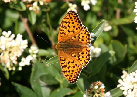
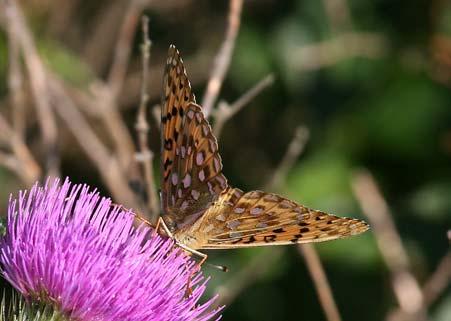
2 right across the sands, but you bear left for Gun Hill. Then it is an easy scramble across the dunes for about another ½ mile to reach the high point of Gun Hill. There are fine views, south to Burnham Overy Staithe and west towards Scolt Head. Gun Hill is a high sand dune, about 16 m above mean sea level, with well-established vegetation but with a volcano-like blow-out at its centre. This is where high winds have torn out the surface plants and lifted sand out to make a large, deep hollow. Around the sides and to the east and south of this hollow, wild privet has become strongly established, with many bushes at least 2m high. Gun Hill is at the western end of a long line of high sand dunes called the Holkham Meals. Dark Green Fritillaries and Graylings have been seen all along these dunes, but only occasionally, and the main Dark Green colony appears to be centred on Gun Hill. The first time I went, it was a sunny, hot afternoon in late June, the traditional weather for the first week of Wimbledon. But there was still a keen wind across the high dunes and butterflies were moving fast. During the walk to Gun Hill, there were plenty of Meadow Browns on the hedgerows through the marshes, and Painted Ladies were everywhere (this being the 2009 good year for them). Almost as soon as I climbed onto Gun Hill, I saw a rushing between its brief re-fuelling stops. Except during early morning and in the evening, males spend only a few seconds drinking nectar before rushing on to continue their search for females in the grass below. During the next hour or so, I must have had another half-dozen sightings, one of which was kind enough to wait on a thistle to be photographed. The next day I returned, and saw another 8 or 10 in the space of about an hour towards the end of the day. A couple of days before, I had been to Horsey Warren, where there were more Dark Greens on the wing but I have been told that they usually emerge later at Gun Hill and that the colony there builds up in July. Most of the fritillaries that I saw on the wing at Gun Hill and Horsey Warren were males. The females like to keep out of sight basking low down or egg-laying. Mating, if it occurs, is invariably low down in long grass. The time to take photographs and to look for females is towards the end of the day, when they will be found drinking nectar from thistles or knapweed, or from brambles if there are any, or, at Gun Hill, from the wild privet which flourishes here. The foodplant for caterpillars is usually one of the species of the violet family. In coastal locations, heath dog violets are used. These are quite similar to common dog violets in appearance, although they are more straggly and they are hard to identify when their flowers have faded. For generations, Burnham Overy provided a port for the surrounding villages, but commercial shipping ceased after the First World War when competition from the railway could be resisted no longer. Now Burnham Overy Staithe is a busy centre for sailing. To reach the sea, small boats come and go along Overy Creek which passes between Scolt Head Island and Gun Hill. Burnham Overy mill is a notable landmark on the A149 about ½ mile west of the Staithe. At the end of the 19 th century, there were three separate mills here. A 16 hp steam engine drove 4 millstones, a watermill used the power of the River Burn to drive 3 millstones, and the present windmill drove three more millstones. The windmill was given to the National Trust in 1958, having not worked since 1919 and has been partially restored. It is now used for holiday accommodation.
.")

3 Holkham National Nature Reserve stretches from Burnham Norton in the west to Blakeney in the east and covers some 4,000 ha (15.5 sq miles). Scolt Head is a separate NNR, and both Holkham and Scolt Head NNRs fall within the North Norfolk Coast SSSI which covers 7,700 ha (30 sq miles). Its management consortium includes the National Trust and the RSPB. For birders, the whole area is well-known for migratory birds and wintering waterflowl, including brent and pink-footed geese, and wigeon. Breeding bird communities include sandwich terns, little terns, common terns, avocets, and bearded tits. The dunes and salt marshes support many different plant communities. On the dunes you may find sea rocket and saltwort, sea sandwort, centaury, bird s-foot trefoil, pyramidal orchids and bee orchids. The rare Jersey cudweed may also be found on the damp, leeward side of the dunes. On the salt marshes, you can expect to see sea aster, sea lavender, sea purslane, sea plantain and sea wormwood as well as many other common and rare seaside plants. A feature of the North Norfolk coastline is that it is in a constant state of flux. To the west, at Holme and Brancaster, localised erosion is threatening grazing marches and the golf club, while at Holkham the opposite is taking place. The dune barriers in Holkham bay have been growing since the 1950s. The result is that the beach behind the dunes here has become muddy where once it was sandy, and samphire and other saltmarsh plants have taken hold. Recently, I met a couple at Holkham Gap who had not been there for ten years. They were astonished to find that the flat beach behind the dunes was now green where they had remembered it as yellow. West side of Gun Hill, looking east Boardwalk of the Norfolk Coast Path, approaching the shore


4 End of the boardwalk; Gun Hill is to the left Little Tern breeding area, north of Gun Hill Mudflats south of Gun Hill, looking west Mudflats in the evening sunshine Scrubby vegetation on Gun Hill Sheltered vegetation where a found a flowering thistle


5 Vegetation on Gun Hill, looking north Masonry relic on Gun Hill View from Gun Hill towards Burnham Overy View from Gun Hill towards Burnham Overy Ordnance Survey marker on Gun Hill Meadow Brown (f) in evening sunlight on the path through Burnham marshes


6 (m) at Gun Hill in late June


7 at Gun Hill


8 Wild privet on the south side of Gun Hill Grassy vegetation on the north side of Gun Hill, looking north with Scolt Head on the left Vegetation on the south side of Gun Hill Birds on the north side of Gun Hill
9 LOCATION Explorer Map 24: Norfolk Coast Central Landranger (pink) Map 132: North West Norfolk Grid references: A149 lay-by car park: TF Gun Hill: TF Gun Hill is on the North Norfolk coast near Burnham Overy Staithe. This is about 12 miles east of Hunstanton. There is parking at Burnham Overy Staithe or at an informal car park on the A149 about ½ mile east of the Overy Staithe. Both car parks are about 2 miles from Gun Hill. Walking is straightforward because the paths are easy, but they are not suitable for wheelchairs. It would be possible to sail to Gun Hill from the Overy Staithe, but landing is difficult because there is no landing stage. Walking on Gun Hill involves gentle scrambling and should not prove difficult except for the rabbit holes. These are everywhere and a dangerous trap for the unwary.
PRESTBURY HILL Gloucestershire
 PRESTBURY HILL Gloucestershire for www.discoverbutterflies.com the website for the book Discover Butterflies in Britain D E Newland 2009 Cheltenham Racecourse from Butterfly Conservation s Prestbury Hill
SHIPTON BELLINGER Hampshire
 SHIPTON BELLINGER Hampshire from www.discoverbutterflies.com the website for the book Discover Butterflies in Britain D E Newland Stonehenge from the north Shipton Bellinger is a small village on the edge
Murlough. Dunes open access, some restricted areas Woodland open access, some restricted areas
 A2 Belfast Road Dundrum Murlough P3 N Dundrum Bay boathouse Ballykinler MOD Firing Range P4 P5 Downshire Bridge inlet floods at high tide Murlough Farm Private PNT Murlough House Private Seals agricultural
Lincolnshire Walks. Grainthorpe. Three circular walks of 2 ¾, 9 and 9 ½ km (1 ¾, 5 ½ and 6 miles)
") Lincolnshire Walks Grainthorpe Three circular walks of ¾, 9 and 9 ½ km (1 ¾, ½ and 6 miles) Introduction Explore the coastal marshes, arable hinterland, Louth Navigation canal and the village of Grainthorpe
Lincolnshire Walks Grainthorpe Three circular walks of ¾, 9 and 9 ½ km (1 ¾, ½ and 6 miles) Introduction Explore the coastal marshes, arable hinterland, Louth Navigation canal and the village of Grainthorpe
Chapel Point to Anderby Creek
 Coastal Country Park Walks Chapel Point to Anderby Creek A CIRCULAR WALK OF 8.5 OR 6 KM (5.3 OR 3.75 MILES) INTRODUCTION The Lincolnshire Coastal Country Park lies between Sandilands, Chapel St Leonards
Holkham. National Nature Reserve
 Holkham National Nature Reserve Welcome to Holkham Holkham is the most extensive, diverse and dramatic nature reserve on a coastline famous for nature reserves. Windswept tidelines, a maze of creeks and
Sandilands to Huttoft Bank
 Coastal Country Park Walks Sandilands to Huttoft Bank A CIRCULAR WALK OF 11KM (7 MILES) INTRODUCTION The Lincolnshire Coastal Country Park lies between Sandilands, Chapel St Leonards and Huttoft on the
Lincolnshire Walks. Ancaster. Three cir cular walks of2 3/4,4or 6km (11/3, 21/2 or 33/4 miles)
") Lincolnshire Walks Ancaster Three cir cular walks of2 3/4,4or 6km (11/3, 21/2 or 33/4 miles) Introduction These walks are set in the attractive countryside around the historic town of Ancaster. The town
Lincolnshire Walks Ancaster Three cir cular walks of2 3/4,4or 6km (11/3, 21/2 or 33/4 miles) Introduction These walks are set in the attractive countryside around the historic town of Ancaster. The town
Outdoor property Access Statement Northumberland Coast
 Outdoor property Access Statement Northumberland Coast 7a The Square, Low Newton-by-the-Sea, Alnwick, Northumberland NE66 3EL T: 01665 576874 E: northumberlandcoast@nationaltrust.org.uk Introduction The
Wilderness Lost? Find out just how natural one of our wild places really is
 Trail Pauline E, Geograph (CCL) Wilderness Lost? Find out just how natural one of our wild places really is Time: 1 hr 30 mins Distance: 3 miles Landscape: coastal Mention Holkham to most people and you
BUTTERFLY REPORT FOR 2010 (Medina Valley Centre) Rachel Luxton
 Rachel Luxton") BUTTERFLY REPORT FOR 2010 (Medina Valley Centre) Rachel Luxton The butterfly index for 2010 is given in figure 1, together with the previous years records for comparison. The transect was walked 25 out
BUTTERFLY REPORT FOR 2010 (Medina Valley Centre) Rachel Luxton The butterfly index for 2010 is given in figure 1, together with the previous years records for comparison. The transect was walked 25 out
Cleeve Common Self-Guided Walk 1 Family Circular
 Cleeve Common Self-Guided Walk 1 Family Circular Start point: Quarry Car Park Nearest postcode: GL52 3PW please note this is for the golf club. To find the quarry car park drive past the golf club car
Green crabs: invaders in the Great Marsh Featured scientist: Alyssa Novak from the Center for Coastal Studies/Boston University
 Name Green crabs: invaders in the Great Marsh Featured scientist: Alyssa Novak from the Center for Coastal Studies/Boston University Research Background: Marshes are areas along the coast that flood with
Chesil Beach, Dorset UK High energy, shingle coastline. Brighton Beach, Sussex UK Pebble beach
 Beaches: Depositional landform Extends from the highest high tide to the lowest low tide. Very important temporary store in coastal system. Accretion: sediment returning to the visible portion of a beach
DYNAMIC COASTS BEACHES AT RISK: Key Stage 3 Resource Pack
 DYNAMIC COASTS BEACHES AT RISK: Key Stage 3 Resource Pack Introduction and Coastal Habitats Summary Beaches At Risk Beaches At Risk (BAR) is an Anglo-French project that brings together geomorphologists,
Warm-up # 7 A day 5/17 - B day 5/18 UPDATE YOUR TABLE OF CONTENTS
 Warm-up # 7 A day 5/17 - B day 5/18 UPDATE YOUR TABLE OF CONTENTS Question: List all examples of surface water on Earth. Answer: Rivers and streams, lakes and reservoirs, (ponds) wetlands, estuaries and
Coast Survey Stretch 03 Seaview High Street to Sandown Zoo
 Coast Survey Stretch 03 Seaview High Street to Sandown Zoo Overview map of the stretch Introduction The route starts at the attractive village of Seaview, through the wooded Priory Bay, passing the remains
Maps The maps provided are a guide and are not to scale. Please use OS Explorer Map 120 (Chichester).
.") A Walker s Guide - Chichester Harbour Useful Information Directions All the walks were tested in 2013. Please note, however, that some footpaths may be diverted and buildings such as pubs may have changed
A Walker s Guide - Chichester Harbour Useful Information Directions All the walks were tested in 2013. Please note, however, that some footpaths may be diverted and buildings such as pubs may have changed
Hatfield Marine Science Center Nature Trail Quest
 Hatfield Marine Science Center Nature Trail Quest 118 The Oregon Coast Book, 2019 20 Edition South Beach NOAA Marine Operations Center Marina Store HMSC HMSC Tsunami Sustainability Quest Quest START START
Examples of estuaries include bays, sounds, salt marshes, mangrove forests, mud flats, swamps, inlets, and sloughs.
 An estuary is a partially enclosed body of water where incoming seawater is mixed with fresh water coming from the land. Examples of estuaries include bays, sounds, salt marshes, mangrove forests, mud
WHAT ARE ECOSYSTEMS? Dr. V. N. Nayak Professor of Marine Biology (Retd)
") WHAT ARE ECOSYSTEMS? Dr. V. N. Nayak Professor of Marine Biology (Retd) An ECOSYSTEM is an interacting system of plant, animals, and humans and the surrounding environment. An ecosystem contains living
WHAT ARE ECOSYSTEMS? Dr. V. N. Nayak Professor of Marine Biology (Retd) An ECOSYSTEM is an interacting system of plant, animals, and humans and the surrounding environment. An ecosystem contains living
Weatherman Walking Sully to Penarth Approximate distance: 5 miles End Start
 Approximate distance: 5 miles For this walk we ve included OS grid references should you wish to use them. 4 End Start 2 3 N W E 1 S Reproduced by permission of Ordnance Survey on behalf of HMSO. Crown
Habitat Fact Sheets. Rocky habitats are dominated by seaweeds and often mussels, which rely on the rocks for attachment.
 Habitat Fact Sheets Habitats in the Gulf of Maine serve many important roles for the environment and for humans as well. These include: cycling nutrients, filtering pollution, trapping sediments, storing
Issues facing this region include the status of the Sluice Creek tide gates, various tidal wetlands, and locations of public access:
 5.6 Guilford Point to Madison Town Line Existing Resources This region extends from Guilford Point to the Madison town line. Named places include Grass Island and the East River. Residential, commercial,
Ravensgate Hill. Results of Butterfly Monitoring. Tricia Atkinson Glos Branch of Butterfly Conservation March Gloucestershire Branch Page 1
 Ravensgate Hill Results of Butterfly Monitoring 213 Gloucestershire Branch Page 1 Tricia Atkinson Glos Branch of Butterfly Conservation March 214 Results of 213 butterfly monitoring on Ravensgate Hill
Tideswell to Castleton
 Tideswell to Castleton 1 Walk summary Length: 14 km, 8.5 miles Maps: OS Explorer OL1 The Peak District - Dark Peak Area, OS Explorer OL24 The Peak District - White Peak Area, OS Landranger 110 Sheffield
coastal Safety challenge Leaders notes
 coastal Safety challenge Leaders notes Leaders notes COASTAL SAFETY CHALLENGE INTRODUCTION The Scout Association is pleased to be working with The Maritime and Coastguard Agency (MCA) to bring you the
Lincolnshire Limewoods Walks. Woodhall Spa. A circular walk of 13km (8 miles)
") Lincolnshire Limewoods Walks Woodhall Spa A circular walk of 13km (8 miles) Introduction The Lincolnshire Limewoods is an area between Wragby, Bardney and Woodhall Spa. It is a fantastic place to explore
Lincolnshire Limewoods Walks Woodhall Spa A circular walk of 13km (8 miles) Introduction The Lincolnshire Limewoods is an area between Wragby, Bardney and Woodhall Spa. It is a fantastic place to explore
MACHRIHANISH DUNES GC: FIXED QUADRAT MONITORING TO JULY
 MACHRIHANISH DUNES GC: FIXED QUADRAT MONITORING TO JULY 2007-2011 1. INTRODUCTION See Management Plan page 45 for summary purpose and table of quadrat types In 2010 four new fairway quadrats were set up:
Walk 2: doniford to east quantoxhead
 Walk 2: doniford to east quantoxhead Length: 9 ¼ miles / 15km Good For: Difficulty: Moderate Theme: Nature Notes: This walk is tidal - please check tide times before setting off. Dogs are welcome but need
Summer Visitors Play in Martha's Vineyard and Nantucket
 Summer Visitors Play in Martha's Vineyard and Nantucket Welcome to This Is America with VOA Learning English. This week on our program, we tell you about two islands in Massachusetts, in the New England
BALCOMBE AND ARDINGLY RESERVOIR, WEST SUSSEX
 BALCOMBE AND ARDINGLY RESERVOIR, WEST SUSSEX 7 miles Circular 4 hours 080816 Challenging Terrain Hi, I'm Luke and this is my West Sussex Weekends walk It's a 7 mile loop from Balcombe rail station, taking
PARCC Research Simulation Task Grade 4 Reading Lesson 8: Practice Completing the Research Simulation Task
 Rationale Goal Task Foci Objectives Materials Procedures PARCC Research Simulation Task Grade 4 Reading Lesson 8: Practice Completing the Research Simulation Task This lesson provides students with practice
ISBA Summer Seminar CALAIS FRANCE. 18 th to 25 th August 2018
 ISBA Summer Seminar CALAIS FRANCE 18 th to 25 th August 2018 THE SITE Location On the Strait of Dover, Calais is situated in a privileged position in North-West Europe with an Eastern access to the Benelux
Cat Island Chain Restoration
 Cat Island Chain Restoration 1820s Fox River Military Road Map to Fort Howard 1845 Chart of Green Bay & Fox River Cat Island Chain - 1938 Cat Island Brown County Aerial Photography, 1938 Historic Western
Slindon Folly - South Downs, West Sussex
 Slindon Folly - South Downs, West Sussex Starts at Park road-side near entrance to Slindon College 2 hours 15 minutes 4.5miles 7.2km Easy ID: 0.1598 Developed by: Chris Mumford Checked by: Rockpit www.ramblersroutes.org
Wattamolla to Big Marley Beach
 Wattamolla to Big Marley Beach 4 hrs 10.4 km Circuit Moderate track 4m This walk is an excellent loop which takes in both the coast and the heathy inland of Royal National Park. Nearly the whole walk has
The Griffon Guide The North Walsham and Dilham Canal Trail
 The Griffon Guide The North Walsham and Dilham Canal Trail This trail explores some of the most accessible and interesting parts of the North Walsham and Dilham Canal. The canal was built in 1825 to allow
Let s take a closer look at estuaries and learn why they are important.
 ave you ever wondered what happens where a river or stream flows into the ocean? When fresh water meets saltwater in a protected bay or inlet, a partially enclosed body of water called an estuary often
Who is Out at Night in the Kuse Nature Preserve, a Nearby Woods or Maybe in Your Backyard?
 Rabbit That Has Gnawed Bark of Cedars During the Night Who is Out at Night in the Kuse Nature Preserve, a Nearby Woods or Maybe in Your Backyard? A nature preserve is not like a zoo. At a zoo, animals
British Mammal Tour Trip Itinerary
 British Mammal Tour Trip Itinerary 2019 Operated by Wildlife Tours & Education Pine Marten Carl Chapman 1 Tour Dates 29 th May to 6 th June 2018 1867 This is a personalised 9 day round Britain trip taking
You, your canoe and the environment
 You, your canoe and the environment www.britishcanoeing.org.uk You, your canoe and the environment England and Wales have a wonderful network of inland and coastal water that are amongst the best in Europe.
Name: Form: 2.To know the difference between Constructive and Destructive wave # $
 Name: Form: Landforms and landscape processes: COASTS 1. To know what factors affect the strength of waves # $ 2.To know the difference between Constructive and Destructive wave # $ 3. To be able to draw
ORCHARD BOOKS 338 Euston Road, London NW1 3BH Orchard Books Australia Level 17/207 Kent Street, Sydney, NSW 2000 A Paperback Original
 RAINBOW Dedicated to Joanna Pilkington, who found fairies in her beautiful garden Special thanks to Narinder Dhami ORCHARD BOOKS 338 Euston Road, London NW1 3BH Orchard Books Australia Level 17/207 Kent
Spring Time Fun: Family, Friends & Solo Adventures
 Spring Time Fun: Family, Friends & Solo Adventures Sitting at work just thinking of fall time hunting for deer, elk, black bear, waterfowl, upland birds and fishing for salmon I wonder what adventures
CHAPTER 8 ASSESSMENT OF COASTAL VULNERABILITY INDEX
 124 CHAPTER 8 ASSESSMENT OF COASTAL VULNERABILITY INDEX 8.1 INTRODUCTION In order to assess the vulnerability of the shoreline considered under this study against the changing environmental conditions,
A circular walk of or km (2 1 4 or miles)
") Grantham A circular walk of 3 3 4 or 5 3 4 km (2 1 4 or 3 1 2 miles) Introduction This relatively short circular walk, which starts in the middle of Grantham, offers plenty of variety. The route takes
Grantham A circular walk of 3 3 4 or 5 3 4 km (2 1 4 or 3 1 2 miles) Introduction This relatively short circular walk, which starts in the middle of Grantham, offers plenty of variety. The route takes
Wallarah Coastal Walk
 Wallarah Coastal Walk 3 hrs 8.3 km Return Hard track 247m This walk starts at Caves Beach and travels south along the coastline, until reaching the Pinney s Headland Lookout. There are many opportunities
Coastal management has lagged behind the growth in population leading to problems with pollution
 Fifty percent of the population of the industrialized world lives within 100 km of a coast. Coastal management has lagged behind the growth in population leading to problems with pollution and natural
Upstreampaddle 25.South arm of the Brunswick River, Simpson s Creek drains the freshwater swamp lands of Tyagarah Nature Reserve, 750 hectares. Furthe
 Upstreampaddle 24 The Brunswick River is a shorter length river on the coastal plain of Northern New South Wales. The areas of interest to canoeists are: the reach from the town of Mullumbimby down to
Species Conclusions Table
 Conclusions Table Project Name: Chesapeake Landing HOA- Breakwaters (NAO-14-0283) Date: February 25, 2014 /Resource Name Loggerhead sea turtle (Caretta caretta) Conclusion ESA Section 7 / Eagle Act Determination
Spring in British Columbia s Great Bear Rainforest Edition. Explore the islands and beaches of the Great Bear Sea. Interact.
 Spring in British Columbia s Great Bear Rainforest 2017 Edition 8-days exploring the outer-islands, observe recovering sea otter populations, and spring bears as they emerge from hibernation. Explore the
Waves- how are they formed and how do they affect the coast?
 Question 7 Coasts Waves- how are they formed and how do they affect the coast? Waves are caused by friction between the wind and water causing the water to swell. The size and energy of a wave is influenced
Heartwood Forest, in Sandridge, Hertfordshire, is a place where everyone can find space, peace, wildlife and miles of beautiful woodland to explore.
 Heartwood Forest Accessibility Statement September 2016 Purpose: This accessibility statement outlines the available facilities and access information for Heartwood Forest. Welcome We, the Woodland Trust,
AFRICA SAFARI G
 AFRICA 2018 - SAFARI G THE ROMANCE OF THE BETTY S BAY PENGUINS AND HERMANUS TOWN BY THE SEA Betty s Bay is a wonderful and easy place to observe the cutest African penguins. They are so close, un- afraid
Beach. Coastal Fishing
 Coastal Discoveries PROGRAM FOR GRADES 6-8 Beach Beach Seine Students explore the high energy surf zone using seine nets to sift and sort organisms. They will learn about functions of producers, consumers,
For more information: Photography: Rijkswaterstaat (Leo Linnartz, Carrie de Wilde, Jurriaan Brobbel, Joop van Houdt), Deltares
, Deltares") Investing in your future. This project was made possible with support from the European Regional Development Fund. Photography: Rijkswaterstaat (Leo Linnartz, Carrie de Wilde, Jurriaan Brobbel, Joop van
Investing in your future. This project was made possible with support from the European Regional Development Fund. Photography: Rijkswaterstaat (Leo Linnartz, Carrie de Wilde, Jurriaan Brobbel, Joop van
Instructions: CLASSIFY ANIMALS AS BLOOD FEEDERS OR NON-BLOODFEEDERS 1. Take out the ADULT CARDS, and place them on the correct boxes 2.
 Instructions: CLASSIFY ANIMALS AS BLOOD FEEDERS OR NON-BLOODFEEDERS 1. Take out the ADULT CARDS, and place them on the correct boxes 2. March the LARVA CARDS with the correct adult cards 3. March the HABITAT
THE AMERICAN SYSTEM OF CONSERVATION FUNDING: CELEBRATING 75 YEARS OF SUCCESS, AND ENSURING ITS FUTURE. 9 th Annual Sportsman - Legislator Summit
 THE AMERICAN SYSTEM OF CONSERVATION FUNDING: CELEBRATING 75 YEARS OF SUCCESS, AND ENSURING ITS FUTURE. 9 th Annual Sportsman - Legislator Summit What The Annual Summit is the most important event of the
Outwood: oaks, buttercups and windmill
 point your feet on a new path Outwood: oaks, buttercups and windmill Distance: 9 km=5½ miles Region: Surrey Author: Schwebefuss Refreshments: Outwood easy walking Date written: 23-may-2014 Last update:
Greenwood. Walks. Cossall Canal Walk. Cossall Canal Walk
 Cossall Canal Walk C5 Cossall Canal Walk C5 Features: Cossall is a picturesque, relatively unspoiled village on the Nottingham canal, four miles south-east of Eastwood. Architecturally interesting. See
Formation and characteristics of different types of beaches
 Activity Title: Formation and characteristics of different types of beaches Focusing questions What different types of beaches are there in New Zealand? How are estuaries different to open coastal sandy
For Creative Minds. Salt Marsh Plants and Animals
 For Creative Minds The For Creative Minds educational section may be photocopied or printed from our website by the owner of this book for educational, non-commercial uses. Cross-curricular teaching activities,
Figure 1. Schematic illustration of the major environments on Mustang Island.
 STOP #1: PACKERY CHANNEL BEACH TO BAY We will start this field guide near the north jetty of Packery Channel and hike across the island to Corpus Christi Bay (fig. 1). The island emerges from the Gulf
Water vole presentations notes
 Water vole presentations notes Slide One Hello everyone, my name is and I work for the Norfolk Wildlife Trust. The Norfolk Wildlife Trust is a conservation charity. Our job is to care for and to protect
9.5 km Circular 3 hours
 MEDIEVAL WAVERLEY Challenging Terrain A 6 mile (9.5km) undulating circular walk from Tilford village passing close to The Sands village and the historic ruins of Waverley Abbey. From the top of Crooksbury
SIR JOSEPH BANKS VOYAGE Port Lincoln - Adelaide 30 January 2 February 2017
 SIR JOSEPH BANKS VOYAGE Port Lincoln - Adelaide 30 January 2 February 2017 Contact Details: Annie Roberts Marketing & Bookings 0432 495 603 enquireoneandall@live.com.au Friends of the One & All Sailing
& r al. Two circular walks of 8 km (5 miles) wal k
 wal k") & Ru r al Two circular walks of 8 km (5 miles) s ford Riv m a t S er wal k Introduction Stamford is noted as being one of the finest stone towns in the country. The stone being local limestone and Collyweston
& Ru r al Two circular walks of 8 km (5 miles) s ford Riv m a t S er wal k Introduction Stamford is noted as being one of the finest stone towns in the country. The stone being local limestone and Collyweston
COASTAL WETLAND SURVEY. Location: Sec. 35, 36 T. 13N R. 17W Quadrangle: Pt. Arena (7 1/2 min) Field Investigator: Gayle Dana Date of Survey : 2/22/78
 Field Investigator: Gayle Dana Date of Survey : 2/22/78") COASTAL WETLAND SURVEY Name of Area: Garcia River County : Mendocino Location: Sec. 35, 36 T. 13N R. 17W Quadrangle: Pt. Arena (7 1/2 min) Ownership : Private Field Investigator: Gayle Dana Date of Survey
COASTAL WETLAND SURVEY Name of Area: Garcia River County : Mendocino Location: Sec. 35, 36 T. 13N R. 17W Quadrangle: Pt. Arena (7 1/2 min) Ownership : Private Field Investigator: Gayle Dana Date of Survey
WALKING GROUP 9 th JANUARY 2013
 WALKING GROUP 9 th JANUARY 2013 For our first walk of 2013 we were fortunate to have a dry, sunny day. Val hand Fred had planned a walk around Stratford on hard footpaths as the fields were still very
3rd GRADE MINIMUM CONTENTS UDI 2: FAUNIA. LIVING THINGS (6)
") 3rd GRADE MINIMUM CONTENTS UDI 2: FAUNIA. LIVING THINGS (6) LIVING AND NON-LIVING THINGS Living things are born, grow, reproduce, grow old, and die. People, plants and animals are all living things. Living
3rd GRADE MINIMUM CONTENTS UDI 2: FAUNIA. LIVING THINGS (6) LIVING AND NON-LIVING THINGS Living things are born, grow, reproduce, grow old, and die. People, plants and animals are all living things. Living
CHAPTER 2. Native Americans and Their Land
 CHAPTER 2 Native Americans and Their Land 2.1 INTRODUCTION Native Americans are believed to be the first people to live in North America They first migrated into the Americas from the continent of Asia
The Arrowhead Patch. Emblem of the National Park Service
 The Arrowhead Patch Emblem of the National Park Service The arrowhead is the emblem of the National Park Service. You will see it in every National Park you visit. It is found at the entrance to the park
holly tree Wellhill Farm Woodyard Bramham House red kites Round House ha-ha
 This 6.4 mile walk around the magnificent Bramham Park Estate has been made possible with the active support of the owner of the Estate, Nick Lane Fox, with funding from Natural England, as part of Defra
Walk Description. Directions
 Title: East Hanningfield Distance: 8 miles / 9 miles Time taken: 3-3½ hours Location: 5 miles south east of Chelmsford Parking: Free car park off The Tye, East Hanningfield, next to the primary school
Blyth Estuary Green Travel Project
 Blyth Estuary Green Travel Project Green Infrastructure Case Study Creating the UK s first Active Travel Town The Connect 2 Blyth Estuary Green Travel Project shows how green infrastructure can enable
There are toilets at Manningtree Station, Flatford (close to the hump back bridge) and in Dedham.
 and in Dedham.") Arriving by Train Main Features of the Walk Outline Route Employs particularly attractive paths, many of which offer impressive views across Dedham Vale. Includes a section along the tidal section of the
Arriving by Train Main Features of the Walk Outline Route Employs particularly attractive paths, many of which offer impressive views across Dedham Vale. Includes a section along the tidal section of the
Studland Bay Context and Learning Aims
 Studland Bay Enquiry 7: How are coastal processes affecting Studland Bay? Context and Learning Aims Pupils will be supported in and outside of the classroom to: Identify; describe and explain the physical
Beautiful Walks from the Blue Ball Inn
 Walk No. 7 COAST AND VALLEY WALK Countisbury, Glenthorne, County Gate, Brendon, Rockford and Wilsham 10 MILES APPROX. Walking time 5 hours approx. (not including breaks)> OS Sheet 64/74 Lynton and Lynmouth.
Marine Ecosystems. Aquatic Ecosystems Section 2
 Marine Ecosystems Marine ecosystems are located mainly in coastal areas and in the open ocean. Organisms that live in coastal areas adapt to changes in water level and salinity. Organisms that live in
Around Spitsbergen Around Spitsb
 Around Spitsbergen Day 1: Largest town, biggest island You touch down in Longyearbyen, the administrative center of Spitsbergen, the largest island of the Svalbard archipelago. Enjoy strolling around this
copyrighted material the Rabbit Jill Mason Merlin Unwin Books
 Rabbit the Jill Mason Merlin Unwin Books Contents Glossary of Terms 6 Introduction 7 1 The Natural History of the Rabbit 9 2 Wild Rabbits around the World 33 3 Rabbits in the UK 43 4 Rabbit Diseases 51
Directions for Day 1: Colwood To Metchosin
 Colwood-Metchosin Page 1 of 8 Directions for Day 1: Colwood To Metchosin Start: Royal Roads University, Birds of a Feather B&B, or at Esquimalt Lagoon Finish: Your accommodation in Metchosin Time: 4-5
Grade 3 Curriculum Link Ideas
 Grade 3 Curriculum Link Ideas Subject Unit Season Activity Description Science Life Cycles All Habitat Survey Students investigate the conditions of habitats within the schoolyard. Spring, summer, fall
Habitat Development: Habitat Boulders Lawson Pier Foreshore Enhancement
 Habitat Development: Habitat Boulders Improve the existing habitat by stabilising beach sediments. Increase biodiversity by creating new habitats and colonisation opportunities. Loose cobble is unstable;
Sustainable Decision Making (SDM) (Foundation and Higher Tier)
 (Foundation and Higher Tier)") GENERAL CERTIFICATE OF SECONDARY EDUCATION GEOGRAPHY B Sustainable Decision Making (SDM) (Foundation and Higher Tier) B561/01/02/RB RESOURCE BOOKLET *B523590611* This resource booklet should be available
GENERAL CERTIFICATE OF SECONDARY EDUCATION GEOGRAPHY B Sustainable Decision Making (SDM) (Foundation and Higher Tier) B561/01/02/RB RESOURCE BOOKLET *B523590611* This resource booklet should be available
B Buckmoth. Look quickly or you ll miss the buckmoth! These bold black and white moths fly quickly and for only a few weeks in the fall.
 A Z A Amphibians The Pine Bush is home to many different amphibians. This is the eastern spadefoot toad. Spadefoot toads have back feet shaped liked shovels used for digging backward into soft sand. If
Beach Coastal ecology PROGRAM FOR GRADES Beach. Coastal Fishing
 Coastal ecology PROGRAM FOR GRADES 9-12 Beach Beach Seine Students explore the high energy surf zone using a seine net to sift and sort critters. They will learn about behavioral and structural adaptations
Ref: LCAA7289 2,000,000. Sea House, 29 Lusty Glaze Road, Porth, Newquay, Cornwall FREEHOLD
 2,000,000 Sea House, 29 Lusty Glaze Road, Porth, Newquay, Cornwall FREEHOLD Located directly above Porth beach. An exceptional, contemporary coastal residence with nearly 7,000sq.ft. of beautifully proportioned
GUIDE to FISH & FISHING on the NORTH YORK MOORS COAST
 GUIDE to FISH & FISHING on the NORTH YORK MOORS COAST HISTORY Fishing has always played an important part in North Yorkshire s maritime heritage. The industry still plays a significant role in everyday
Estuarine Shoreline Stabilization
 Estuarine Shoreline Stabilization Property Owner s Guide to Determining the Most Appropriate Stabilization Method Estuarine shorelines are dynamic features that experience continued erosion. Land is lost
Students use wildlife survey study techniques to discover the cause of the drop in a wood duck population.
 Fowl Play Summary Students use wildlife survey study techniques to discover the cause of the drop in a wood duck population. Background Wood ducks spend most of their time in ponds and streams near woods.
* Appalachian Mountains -the mountain range in the Eastern U.S. which terminates in north-central Alabama
 MR. SAND TEACHER'S MANUAL INTRODUCTION: Although Mr. Sand is a cartoon presentation that is attractive to children (of all ages), the material is technically accurate and quite significant to our understanding
Map 8: Ayrshire Coast: Ardrossan North Bay to Stevenston Pier Map Content Descriptions
 Map 8: Ayrshire Coast: Ardrossan North Bay to Stevenston Pier Map Content Descriptions 1. Built Heritage and Archaeology A total of twenty four sites were recorded in the area covered by Map 8. Of these
Wild Coast Adventure Trail, South Africa
 Wild Coast Adventure Trail, South Africa Itinerary Discover the rugged and unspoilt natural beauty of the Wild Coast. Explore rocky headlands, rolling hills and vast tracks of superb golden beaches. This
Site The fieldwork should be completed at a localised site on the Victorian coast (or elsewhere).
.") Coastal fieldwork Studying the coast provides the opportunity to conduct fieldwork in coastal regions. This fieldwork could investigate the geographic characteristics of the coast and how they change over
Coastal fieldwork Studying the coast provides the opportunity to conduct fieldwork in coastal regions. This fieldwork could investigate the geographic characteristics of the coast and how they change over
The. Griffon. Guide. raise the. length. success and
 The Griffon Guide The North Walsham and Dilham Canal Trail This trail explores some of the most accessible and nteresting parts of the North Walsham and Dilham Canal. The canal was built in 1825 to allow
F R E E R E s E R v o i R WA L K s REsERvoiR WALKs To BLoW AWAY THE CoBWEBs BRougHT To You BY
 F R E E r e s e r v o i r WALKS reservoir WALKS TO BLOW AWAY THE COBWEBS Brought to you by Only available in Yorkshire. We look after 72,000 acres of land in Yorkshire, spanning the North York Moors, the
lot across from the Barrington Post Office, please do not use Woolen Mill Museum parking if there are more than 1 vehicle.
 BARRINGTON Launch Rating Moderate to difficult depending on your skills. Launch Description This launch is usable at high tide using proper skills to enter and exit your kayak. Put in just above the concrete
Visual impact assessment viewpoint analysis
 Visual impact assessment viewpoint analysis 1 Introduction In this section we analyse the most important viewpoints affected by this development. In each viewpoint where it is relevant we have cross referred