Identifying Mule Deer Migration Routes Along the Pinedale Front
|
|
|
- Vernon Fields
- 6 years ago
- Views:
Transcription


1 Identifying Mule Deer Migration Routes Along the Pinedale Front Prepared for: The Wyoming Wildlife and Natural Resource Trust 500 East Fremont Riverton, Wyoming Prepared by: Hall Sawyer and Matthew Kauffman Wyoming Cooperative Wildlife Research Unit University of Wyoming 1000 E. University Ave, Laramie, WY May 10, 2008
2 Overview: There are an estimated 28,000 mule deer in the upper Green River Basin (i.e., Sublette Herd, Wyoming Game and Fish Department [WGFD] 2006), most of which annually migrate 40 to 100 miles to summer in portions of 5 mountain ranges (Sawyer et al. 2005). Accordingly, successful management of this deer herd will require that functional migration routes remain intact. Given the increased levels of both energy (Bureau of Land Management [BLM] 2005) and housing (Taylor and Lieske 2002) development in Sublette County, identifying and conserving migration routes has become increasingly important. Currently, migration routes are depicted by simply connecting the dots between locations of marked animals (e.g., Sawyer et al. 2005, Berger et al. 2006, White et al. 2007). However, because a line has no area associated with it (i.e., is it 10 feet or 1 mile wide?), the management value of this approach is limited and can be especially difficult to incorporate into planning documents (e.g., National Environmental Policy Act, Resource Management Plans, etc.) or on the ground management prescriptions (e.g., water development, prescribed burns, sagebrush treatments). Further, without specific knowledge of the relative amounts of use (high, medium, low) migration routes receive, it is difficult to prioritize specific segments for conservation or enhancement. The purpose of this project was to use existing GPS data collected from radio collared mule deer to estimate the utilization distributions (UD) of migration route(s) originating from the Pinedale Front Winter Range, located along the southwest base of the Wind River Range. The UD provides information on both the width of migration route(s) and intensity of use across the route(s). Having the ability to estimate the width and relative amounts of use migration routes receive should assist agencies, industry, and non government organizations (NGO) with incorporating them into land use planning and to identify specific segments for habitat improvement. This science based tool was also intended to compliment and improve on the ground enhancement projects aimed at benefiting mule deer migration by ensuring that they are implemented in appropriate areas. On the ground habitat manipulations are becoming more common in the region because of funding opportunities available through the Wildlife and Natural Resource Trust ( and the Jonah Interagency Mitigation and Reclamation Office ( Accordingly, there is a need to 2
3 identify areas where management prescriptions may be most beneficial to wildlife and provide effective off site mitigation. Additionally, the methods developed for this project may be used with other GPS data sets across the state to identify migration routes of other species, especially those threatened by energy or housing development (e.g., Sawyer and Kauffman 2008). Figure 1. Example of a utilization distribution (UD) estimated for an individual migration route. The UD provides information on both the width and relative amounts of use across the route, whereas a typical migration route line (blue) has no area associated with it. Project Area The project area begins approximately 15 miles northeast of Farson and extends 40 miles north to Pinedale and Fremont Lake (Figure 2). The project area overlaps with priority sagebrush (Figure 3) and mountain shrub habitats identified in the Strategic Habitat Plan developed by the WGFD (2001) and contains areas designated as crucial mule deer winter range (Figure 4). The general project area includes approximately 210,000 acres, of which 65% is administered by the BLM, 20% Private, 9% State, 3% WGFD, and 2% USFS (Figure 5). 3


4 Figure 2. Location of project area and sagebrush habitats in the Upper Green River Basin. Figure 3. Typical sagebrush habitat in the project area. 4


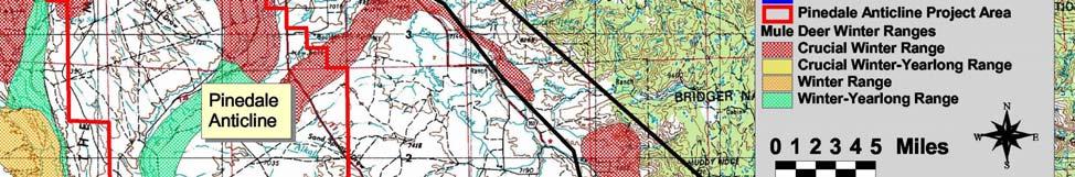

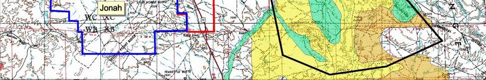
5 Figure 4. Location of designated mule deer winter ranges in the general project area. 5
6 Figure 5. Land ownership across the general project area. Methods We used existing GPS data collected from 24 radio collared mule deer between 2003 and 2007 to estimate the UDs of migration routes originating from the Pinedale Front Winter Range Complex. A UD refers to the relative frequency or probability of an animal s location over time (Worton 1987). In the case of migration routes, a UD provides a probabilistic measure of where mule deer migrations occurred. A portion of our GPS collars were deployed for 1 year, while others were functioning for a full 2 years. Depending on how long the GPS collar was deployed, an individual deer collected data for one or more spring and fall migrations (Table 1). We documented 40 migrations for the 24 radio collared mule deer, including 28 spring and 12 fall migrations (Table 1). 6
7 We used a Brownian Bridge Motion Model (BBMM; Horne et al. 2007) to estimate UDs for migration routes of individual deer (n=24), using the sequence of GPS locations that occurred between the Big Sandy River and Fremont Lake. Areas south of the Big Sandy River were not included because it was considered winter range. Areas north of Fremont Lake were not included because we did not have enough data to analyze beyond that point. The BBMM uses the time elapsed between locations and the rate of movement to estimate the probability of occurrence between successive locations (Horne et al. 2007). All of our mule deer locations were collected at 2 hr intervals, but depending on the rate of movement, the predicted width of the migration route varied (Figure 1). Probabilities were calculated for every 50 x 50m cell in the study area. Because mule deer demonstrated a high fidelity to their migration routes across seasons and years, we combined individual UDs to generate a population level UD or migration route. We color coded the probability values into 25% quartiles and classified the top 25% as high use and the lowest 25% were as low use. The width of the UD corresponds to a 99% contour interval. The population level migration route was generated as a grid theme in ArcView to provide easy digital access for agencies and others who want to access this information to indentify priority conservation areas. 7
8 Table 1. Utilization distributions (UD) were estimated for 40 migrations (28 spring, 12 fall) collected from 24 radio collared mule deer. The number of migrations collected for each mule deer ranged from 1 to 3. DEER ID Spring 2003 Fall 2003 Spring 2004 Fall 2004 Spring 2005 gps0203_871a gps0203_870 gps0203_873a gps0203_867 gps0203_855 gps0203_844 gps0203_874 gps0304_876 gps0304_870a gps0304_867a gps0304_864a gps0304_861 Fall 2005 Spring 2006 Fall 2006 gps0405_878a gps0405_877a gps0405_872 gps0405_869 gps0405_861 gps0405_860 gps0506_869a gps0506_867a gps0506_866a gps0506_862a gps0506_861a gps0506_860a Spring 2007 Results We calculated a UD for the population level migration route of mule deer that winter in the Pinedale Front Winter Range (Figures 6 and 7). The UD included 40 migrations from the 24 radio collared mule deer (Table 1). The UD represents a probabilistic measure of where both spring and fall migrations occurred during 2003 through 2007, although the fall migrations (n=12) were not represented as well as the spring (n=28). In Figures 6 and 7, the red and orange coloring represent areas with the highest probability of use, while yellow and brown represent areas with lowest probability of use. Importantly, higher use areas (red and orange) corresponded to areas where rates of movement were slow, whereas lower use areas (yellow and brown) corresponded to areas with high rates of movement. Two segments of the 8


9 migration route had unusually high movement rates, where deer spent little time. These segments included the area around Muddy Creek and the area between Silver and Scab Creek, where a pronounced split in the route occurred. Figure 6. Utilization distribution (UD) of population level migration route from the Pinedale Front Winter Range to Fremont Lake, based on 40 migrations collected from 24 radio collared mule deer, Background is 1:100,000 topo map. 9
 of population level")


10 Figure 7. Utilization distribution (UD) of population level migration route from the Pinedale Front Winter Range to Fremont Lake, based on 40 migrations collected from 24 radio collared mule deer, Background is satellite image taken in Discussion and Management Implications This project provides an objective and empirically based delineation of the populationlevel migration route used by a large segment of mule deer in the upper Green River Basin. When relative amounts of migration route use are mapped, as in Figures 6 and 7, the natural tendency is to interpret high use areas as the most biologically important and low use areas as 10
11 the least important. While this interpretation is generally correct, it is important to recognize that high use areas reflect habitats where deer moved slowly (e.g., foraging, resting) and lowuse areas reflect habitats where deer moved quickly. Thus, we assume that high use areas provide key foraging and resting habitat, while lower use areas provide movement corridors and connectivity between high use areas. High use areas were typically connected by mediumhigh (orange) and medium low (yellow) use areas, providing the necessary connectivity to ensure mule deer can move between winter and summer ranges. From a management perspective, distinguishing between high and low use areas across a population level migration route may be useful for planning, prioritizing land use decisions, and identifying where on the ground habitat enhancements should occur. For example, given that high use areas provide foraging and resting habitat along the migration route, management strategies may focus on maintaining healthy sagebrush habitats in these areas, while minimizing human disturbance (e.g., road construction) and habitat loss. Or, in a scenario where limited funds are available for a conservation easement, the high use segments would take priority over the low use. In contrast to the high use areas, the low use areas appear to function as simple movement corridors, rather than major foraging or resting areas. However, given that mule deer use these areas considerably less, they may have the most potential for improvement. For example, why do mule deer move quickly through the Muddy Creek region? And why does the migration route split into 2 distinct routes between Silver and Scab Creek? Is there potential to improve these areas for mule deer migration by habitat enhancement, fencing modification, or some other management prescription? Figures 6 and 7 provide a valuable tool for not only identifying where mule deer migrations occur, but also what segments of the migration route may require, and benefit from, the most attention. Another important management consideration is that mule deer migration routes tend to become less distinct as distance from winter range increases (Thomas and Irby 1990, Sawyer and Kauffman 2008). A recent analysis conducted in south central Wyoming illustrates that common and intensively used migration routes splinter into multiple, less distinct routes, as mule deer move further from winter range (Sawyer and Kauffman 2008). A useful analogy for this pattern is to think of the population level migration routes as a road system, where the 11
12 heavily used routes close to winter range are analogous to interstates. As distance from winter range increases, those interstates turn into highways that receive less deer use (traffic) and eventually county roads with even lower levels of use. Accordingly, the migratory segments most important to the mule deer population occur along the interstates (close to winter range), because those are the regions that receive the highest levels of use from the most number of deer. The mule deer in this study migrated miles between seasonal ranges, but we were only able to precisely document 32 miles of the migration route. Had we documented the entire length of the migration routes, we would have seen the population level route splinter into multiple routes with lower levels of deer use, as distance from winter range increased. It is important to recognize that the 32 mile segment in this study represents a common, high use route analogous to an interstate, and as such, conservation of this segment should be a top priority for managers. Because mule deer from this winter range migrate to 5 different mountain ranges (i.e., Wind River Range, Wyoming Range, Salt River Range, Snake River Range, and Gros Ventre Range), the benefits of conserving this relatively small migration route will indirectly affect a much larger area. And because the migration route occurs almost exclusively in sagebrush habitats, any subsequent conservation or enhancements efforts directed to the migration route will benefit other sagebrush dependent species, such as sage grouse and pronghorn. Delineating accurate boundaries of population level migration route should improve the ability of agencies, like the Jonah Interagency Office (JIO) to meet their stated objectives that include Maintaining migration corridors sufficient to allow the unimpeded seasonal movements of migratory wildlife. Maps and data from this project will be made available in digital (GIS) format to the WGFD, the BLM, the JIO, the Nature Conservancy, and the Wyoming Wildlife and Natural Resource Trust. We encourage conservation easements and habitat improvements aimed at benefiting migratory mule deer on the east side of the upper Green River Basin be targeted within the region delineated in Figures 6 and 7. We recommend future research efforts 1) identify migration routes to and from other winter ranges that support large numbers of ungulates, and 2) determine the habitat characteristics (e.g., shrub characteristics, 12
13 slope, aspect, etc.) of high use and low use areas, such that managers can determine how best to mitigate migratory segments when or if they are impacted by development. We recognize that most WWNRT and JIO funding is allocated to on the ground habitat manipulation or conservation easement projects, and we understand the importance of implementing these types of direct conservation efforts. However, in order for habitat improvements, conservation easements, or off site mitigation to benefit migratory species whose ranges extend miles, we must have the ability to identify where site specific improvements should occur. We hope this project provides the necessary tool to identify and prioritize those areas along the Pinedale Front that are most important for sustaining migration routes of mule deer in the upper Green River Basin. Literature Cited Bureau of Land Management [BLM] Oil and gas activity on public lands in the United States and Wyoming. USDI BLM, Wyoming State Office, Cheyenne, USA. Berger, J., S. L. Cain, and K. M. Berger Connecting the dots: an invariant migration corridor links the Holocene to the present. Biology Letters doi: /rsbl Horne, J. S., E. O. Garton, S. M. Krone, and J. S. Lewis Analyzing animal movements using Brownian Bridges. Ecology 88: Sawyer, H., F. Lindzey, and D. McWhirter Mule deer and pronghorn migration in western Wyoming. Wildlife Society Bulletin 33: Sawyer, H., and M. Kauffman Identifying mule deer migration routes in the Atlantic Rim Project Area. Wyoming Cooperative Fish and Wildlife Research Unit, Laramie, Wyoming. Thomas, T., and L. Irby Habitat use and movement patterns by migrating mule deer in southeast Idaho. Northwest Science 64: White, P. J., T. L. Davis, K. K. Barnowe Meyer, R. L. Crabtree, and R. A. Garrott Partial migration and philopatry of Yellowstone pronghorn. Biological Conservation 135: Worton, B. J A review of models of home range for animal movement. Ecological Modeling 38: Wyoming Game and Fish Department [WGFD] Strategic Habitat Plan. Wyoming Game and Fish Department, Cheyenne, Wyoming. Wyoming Game and Fish Department [WGFD) Job Completion Report for the Jackson/Pinedale Region. Wyoming Game and Fish Department, Cheyenne, Wyoming. 13
Identifying Mule Deer Migration Routes
 Identifying Routes in the Atlantic Rim Project Area Prepared for: The Wildlife Heritage Foundation of Wyoming Prepared by: Hall Sawyer and Matthew Kauffman Wyoming Cooperative Wildlife Research Unit University
Identifying mule deer migration routes to and from the Pinedale Anticline Project Area
 Identifying mule deer migration routes to and from the Pinedale Anticline Project Area Prepared For: University of Wyoming School of Energy Resources Dept. 3012, 1000 E. University Ave. Laramie, WY 82071
Evaluating the Influence of Development on Mule Deer Migrations
 2013 Annual Report Evaluating the Influence of Development on Mule Deer Migrations Teal Wyckoff 1,2, Matt Kauffman 3, Hall Sawyer 4, Shannon Albeke 2 1 Wyoming Cooperative Fish and Wildlife Research Unit,
The Role and Economic Importance of Private Lands in Providing Habitat for Wyoming s Big Game
 March 2004 B-1150 The Role and Economic Importance of Private Lands in Providing Habitat for Wyoming s Big Game By Roger Coupal, Department of Agricultural and Applied Economics; Gary Beauvais, Wyoming
Improving Big Game Migration Corridors in Southwest Wyoming
 June 2010 WYOMING open spaces William D. Ruckelshaus Institute of Environment and Natural Resources Department of Agricultural and Applied Economics Wyoming Natural Diversity Database Wyoming Geographic
Thank you in advance for considering this important issue. We hope that we may hear from you soon with a positive answer.
 TRANSMITTED BY EMAIL TO April 13, 2018 Mary Jo Rugwell State Director Bureau of Land Management 5353 Yellowstone Cheyenne, WY 82009 Dear Director Rugwell: I am writing on behalf of the
Mule deer migration and the Bald Mountain Mine a summary of baseline data
 Mule deer migration and the Bald Mountain Mine a summary of baseline data Prepared for: Nevada Department of Wildlife 1100 Valley Road Reno, NV 89512 Prepared by: Hall Sawyer and Megen Brittell Western
Interagency Special Status/Sensitive Species Program FY2005 Inventory & Conservation Planning Status Report
 Interagency Special Status/Sensitive Species Program FY2005 Inventory & Conservation Planning Status Report PROJECT TITLE: Crooked River National Grassland Pygmy Rabbit Habitat Assessment and Survey PROJECT
UTAH ACTION PLAN. For
 UTAH ACTION PLAN For Implementation of Department of the Interior Secretarial Order 3362: Improving Habitat Quality in Western Big-Game Winter Range and Migration Corridors Introduction - There was a great
2005 Annual Report. Prepared for: Questar Exploration and Production Company Independence Plaza th St., Suite 500 Denver, CO 80265
 2005 Annual Report SUBLETTE MULE DEER STUDY (PHASE II): Long-term monitoring plan to assess potential impacts of energy development on mule deer in the Pinedale Anticline Project Area. Prepared for: Questar
WYOMING ACTION PLAN. For
 WYOMING ACTION PLAN For Implementation of Department of the Interior Secretarial Order 3362: Improving Habitat Quality in Western Big-Game Winter Range and Migration Corridors Introduction The purpose
NEVADA ACTION PLAN. For
 NEVADA ACTION PLAN For Implementation of Department of the Interior Secretarial Order 3362: Improving Habitat Quality in Western Big-Game Winter Range and Migration Corridors Introduction - Secretarial
Hunting, Fishing, Recreational Shooting, and Wildlife Conservation Opportunities and Coordination with States, Tribes, and Territories
 THE SECRETARY OF THE INTERIOR WASHINGTON ORDER NO. 3356 Subject: Hunting, Fishing, Recreational Shooting, and Wildlife Conservation Opportunities and Coordination with States, Tribes, and Territories Sec.
Mule deer and pronghorn migration in western Wyoming
 Mule deer and pronghorn migration in western Wyoming Author(s): Hall Sawyer, Fred Lindzey, Doug McWhirter Source: Wildlife Society Bulletin, 33(4):1266-1273. 2005. Published By: The Wildlife Society DOI:
Influence of nutritional condition on migration, habitat selection and foraging ecology of elk (Cervus elaphus) in western Wyoming
 in western Wyoming") Influence of nutritional condition on migration, habitat selection and foraging ecology of elk (Cervus elaphus) in western Wyoming June 2010 Annual Report Wyoming Game and Fish Department Project WYGF
Influence of nutritional condition on migration, habitat selection and foraging ecology of elk (Cervus elaphus) in western Wyoming June 2010 Annual Report Wyoming Game and Fish Department Project WYGF
WADE WEST INCENTIVE TAGS 2016 NDOW- REPORTING BIOLOGIST SCOTT ROBERTS
 WADE WEST INCENTIVE TAGS 2016 NDOW- REPORTING BIOLOGIST SCOTT ROBERTS PROGRAM OVERVIEW As you are all aware, the difficulty of this program is that a large portion of it is subjective. It is not based
COLORADO ACTION PLAN. For
 COLORADO ACTION PLAN For Implementation of Department of the Interior Secretarial Order 3362: Improving Habitat Quality in Western Big-Game Winter Range and Migration Corridors INTRODUCTION Colorado Parks
Potential Effects of Oil and Gas Development on Mule Deer and Pronghorn Populations in Western Wyoming
 University of Nebraska - Lincoln DigitalCommons@University of Nebraska - Lincoln U.S. Bureau of Land Management Papers U.S. Department of the Interior 2002 Potential Effects of Oil and Gas Development
Wyoming Public Lands Initiative (WPLI) Fortification Creek Advisory Committee Meeting March 13, 2017
 Fortification Creek Advisory Committee Meeting March 13, 2017") Wyoming Public Lands Initiative (WPLI) Fortification Creek Advisory Committee Meeting March 13, 2017 Present: Commissioner Rusty Bell, Campbell County; Commissioner Bill Novotny, Johnson County; Commissioner
Wyoming Public Lands Initiative (WPLI) Fortification Creek Advisory Committee Meeting March 13, 2017 Present: Commissioner Rusty Bell, Campbell County; Commissioner Bill Novotny, Johnson County; Commissioner
BLACK GAP WMA/ECLCC MULE DEER RESTORATION PROJECT UPDATE. February 2, 2016
 //CEMEX USA BLACK GAP WMA/ECLCC MULE DEER RESTORATION PROJECT UPDATE February 2, 2016 Mule deer numbers at Black Gap Wildlife Management Area (BGWMA) and El Carmen Land & Conservation Company-CEMEX USA
PROTECTING SAGE GROUSE AND THEIR HABITAT IN THE WEST. John Harja Senior Counsel on Detail to the Public Lands Office
 PROTECTING SAGE GROUSE AND THEIR HABITAT IN THE WEST John Harja Senior Counsel on Detail to the Public Lands Office Chick Female (Hen) Male (Cock) Nest w eggs Lek Sage-grouse need sagebrush. Landscape-scale
Idaho State Action Plan, DOI Secretarial Order
 IDAHO ACTION PLAN For Implementation of Department of the Interior Secretarial Order 3362: Improving Habitat Quality in Western Big-Game Winter Range and Migration Corridors INTRODUCTION - Many wildlife
Chagrin River TMDL Appendices. Appendix F
 Appendix F The following are excerpts from the Eastern Brook Trout Joint Venture s Conservation Strategy (Working Draft v.6), Conserving the Eastern Brook Trout: Strategies for Action Found at: http://www.easternbrooktrout.org/constrategy.html
BLACK GAP WMA/ECLCC MULE DEER RESTORATION PROJECT UPDATE. October 1, 2017
 //CEMEX USA BLACK GAP WMA/ECLCC MULE DEER RESTORATION PROJECT UPDATE October 1, 2017 Mule deer numbers at Black Gap Wildlife Management Area (BGWMA) and El Carmen Land & Conservation Company-CEMEX USA
Losing Ground. Energy Development s Impacts on the Wildlife, Landscapes, and Hunting Traditions of the American West
 Energy Development s Impacts on the Wildlife, Landscapes, and Hunting Traditions of the American West Barbara Wheeler T he iconic game species of the American West are in perilous decline, as migratory
Sublette County WPLI Advisory Committee Meeting Summary April 5, 2017 Pinedale, WY
 Sublette County WPLI Advisory Committee Meeting Summary April 5, 2017 Pinedale, WY Draft for Review Committee Members Present: Dave Bell, General Public Bill Lanning, Motorized Recreation Monte Skinner,
Colorado West Slope Mule Deer Strategy Public Engagement Report
 Colorado West Slope Mule Deer Strategy Public Engagement Report S U M M A R Y P R E S E N T A T I O N T O C O L O R A D O P A R K S A N D W I L D L I F E C O M M I S S I O N P R E S E N T E D BY T H E
Copyright 2018 by Jamie L. Sandberg
 Copyright 2018 by Jamie L. Sandberg All rights reserved. This book or any portion thereof may not be reproduced or used in any manner whatsoever without the express written permission of the publisher,
Mule Deer. Dennis D. Austin. Published by Utah State University Press. For additional information about this book
 Mule Deer Dennis D. Austin Published by Utah State University Press Austin, D.. Mule Deer: A Handbook for Utah Hunters and Landowners. Logan: Utah State University Press, 2010. Project MUSE., https://muse.jhu.edu/.
The Lake Creek Ranch. Located in the foothills of the Owl Creek Mountains in western Hot Springs County, Wyoming
 The Lake Creek Ranch Located in the foothills of the Owl Creek Mountains in western Hot Springs County, Wyoming Experienced Professional Ranch Brokers Specializing in the sale of ranches, farms, & recreational
Utah. North Stansbury Mountains Wilderness Study Area Site-Specific Monitoring Guide
 Utah North Stansbury Mountains Wilderness Study Area Site-Specific Monitoring Guide 1 General Information WildSNAP Monitoring Peter Woodruff, American Conservation Experience Coordinator Phone (801) 989-7069
[FWS R1 ES 2015 N076; FXES FF01E00000] Endangered and Threatened Wildlife and Plants; Revised Draft Recovery Plan for
![[FWS R1 ES 2015 N076; FXES FF01E00000] Endangered and Threatened Wildlife and Plants; Revised Draft Recovery Plan for](/thumbs/87/96960993.jpg "[FWS R1 ES 2015 N076; FXES FF01E00000] Endangered and Threatened Wildlife and Plants; Revised Draft Recovery Plan for") This document is scheduled to be published in the Federal Register on 06/04/2015 and available online at http://federalregister.gov/a/2015-13624, and on FDsys.gov DEPARTMENT OF THE INTERIOR Fish and Wildlife
This document is scheduled to be published in the Federal Register on 06/04/2015 and available online at http://federalregister.gov/a/2015-13624, and on FDsys.gov DEPARTMENT OF THE INTERIOR Fish and Wildlife
Wyoming Range Mule Deer Project. Summer 2017 Update
 Wyoming Range Mule Deer Project Summer 2017 Update TABLE OF CONTENTS PROJECT BACKGROUND... 3 WINTER 2016/2017... 4 Adult Survival... 4 Fawn Survival... 4 MARCH 2017 ADULT CAPTURES... 5 Nutritional Condition...
2017 LATE WINTER CLASSIFICATION OF NORTHERN YELLOWSTONE ELK
 2017 LATE WINTER CLASSIFICATION OF NORTHERN YELLOWSTONE ELK A collaborative survey by the Northern Yellowstone Cooperative Wildlife Working Group Report Prepared by: Karen Loveless, Montana Fish Wildlife
Fremont County Related Hunting and Fishing Spending, 2015
 Fremont County Related Hunting and Fishing Spending, 2015 For the Wyoming Wildlife Federation University of Wyoming, Department of Agricultural & Applied Economics David T. Taylor & Thomas Foulke September,
Teton County Related Hunting and Fishing Spending, For the Wyoming Wildlife Federation. David T. Taylor & Thomas Foulke
 Teton County Related Hunting and Fishing Spending, 2015 For the Wyoming Wildlife Federation University of Wyoming, Department of Agricultural & Applied Economics David T. Taylor & Thomas Foulke 1 February
The Greater Sage-Grouse:
 The Greater Sage-Grouse: Hunter opinions regarding potential conservation strategies in eleven western states For: National Wildlife Federation October 30, 2014 PO Box 6435 Fernandina Beach, FL 32035 Tel
Owl Canyon Corridor Project Overview and Summary
 Owl Canyon Corridor Project Overview and Summary December 22, 2008 The Owl Canyon corridor (generally the connection between the I-25 / Larimer County Road 70 interchange and the US 287 / Larimer County
Instream Flow Water Rights in the Snake and Salt River Basins. Paul Dey, Wyoming Game and Fish Department
 Instream Flow Water Rights in the Snake and Salt River Basins Paul Dey, Wyoming Game and Fish Department Snake/Salt River Basin Instream Flow Water Rights Basis for instream flow work Segments, quantities,
2017 Wyoming Outdoor Hall of Fame Nomination Form
 2017 Wyoming Outdoor Hall of Fame Nomination Form Nominee Information: Name: Gary B. Butler Mailing Address: 1457 Turqouise, Cheyenne, WY 82009 Phone Number and Email: 307-214-7310 garybutler1908@gmail.com
Wyoming Game and Fish Department
 Wyoming Game and Fish Department Pinedale Region Newsletter Trumpeter Count Wyoming Game and Fish Department Nongame Biologist Susan Patla recently conducted an annual winter survey for trumpeter swans
2012 Diamond Complex Assessment BLM administered: Battle Mountain, Ely, Elko districts
 2012 Diamond Complex Assessment BLM administered: Battle Mountain, Ely, Elko districts wild horse removal scheduled January 2013 Horse Canyon, Diamond HMA July 2012 Preliminary Report (Final Version) of
WYOMING 2014 STATEWIDE HUNTING SEASON FORECAST. PRONGHORN (antelope)
") WYOMING 2014 STATEWIDE HUNTING SEASON FORECAST PRONGHORN (antelope) JACKSON REGION In the Jackson Region, northern portions of the Sublette pronghorn herd include Hunt Areas 85 and 86. Although hunter
WYOMING 2014 STATEWIDE HUNTING SEASON FORECAST PRONGHORN (antelope) JACKSON REGION In the Jackson Region, northern portions of the Sublette pronghorn herd include Hunt Areas 85 and 86. Although hunter
Sublette Moose Project! 2014 Capture Report
 Sublette Moose Project! 2014 Capture Report F67 makes her way back to the willows of Horse Creek after being released from capture. PROJECT BACKGROUND In February 2011, we began research on Shiras moose
The Blue Heron Slough Conservation Bank
 1 The Blue Heron Slough Conservation Bank CONSERVATION BANKING July 19-23, 2010 CASE STUDY SERIES The Blue Heron Slough Conservation Bank (Washington) I. OVERVIEW & BACKGROUND: Location: Snohomish River
Deer-Elk Ecology Research Project
 Deer-Elk Ecology Research Project 2016 Summer Update Spring helicopter captures for the DEER Project wrapped up in late April this year. Given concerns about potentially missing migratory animals that
United States Department of the Interior
 United States Department of the Interior FISH AND WILDLIFE SERVICE Virginia Ecological Services Field Office 6669 SHORT LANE GLOUCESTER, VA 23061 PHONE: (804)693-6694 FAX: (804)693-9032 URL: www.fws.gov/northeast/virginiafield/
5 CIRCULATION AND STREET DESIGN
 5 CIRCULATION AND STREET DESIGN This chapter describes circulation and streetscape improvements proposed for the Northwest Chico Specific Plan Area. It includes detailed design specifications for existing
Influence of nutritional condition on migration, habitat selection and foraging ecology of elk (Cervus elaphus) in western Wyoming.
 in western Wyoming.") Influence of nutritional condition on migration, habitat selection and foraging ecology of elk (Cervus elaphus) in western Wyoming. January 2011 Annual Report Wyoming Game and Fish Department Project WYGF
Influence of nutritional condition on migration, habitat selection and foraging ecology of elk (Cervus elaphus) in western Wyoming. January 2011 Annual Report Wyoming Game and Fish Department Project WYGF
Department of Environmental Quality
 Department of Environmental Quality To protect, conserve, and enhance the Quality of Wyoming s environment for the benefit of current and future generations Dave Freudenthal, Governor John Corra, Director
Job Title: Game Management, Subsection B Game Management Mountain Lion. SPECIES: Mountain Lion
 SPECIES: Goal: Manage the mountain lion population, its numbers and distribution, as an important part of Arizona s fauna and to provide mountain lion hunting recreation opportunity while maintaining existing
TRCP National Sportsmen s Survey Online/phone survey of 1,000 hunters and anglers throughout the United States
 #17144 TRCP National Sportsmen s Survey Online/phone survey of 1,000 hunters and anglers throughout the United States Methodology Public Opinion Strategies conducted a national survey of N =1,000 voters
United States Department of the Interior
 United States Department of the Interior FISH AND WILDLIFE SERVICE Virginia Ecological Services Field Office 6669 SHORT LANE GLOUCESTER, VA 23061 PHONE: (804)693-6694 FAX: (804)693-9032 URL: www.fws.gov/northeast/virginiafield/
Wildlife Issues With Oil and Gas Exploration. Peter D. McKone, CWB Senior Project Director
 Wildlife Issues With Oil and Gas Exploration Peter D. McKone, CWB Senior Project Director pmckone@wcgrp.com 817-946-7379 Outline Nationwide Issues Regional Issues Industry Examples General Wildlife Impacts
THE WESTERN NATIVE TROUT INITIATIVE PLAN FOR STRATEGIC ACTIONS November GOALS, OBJECTIVES, and KEY STRATEGIC ACTIONS
 THE WESTERN NATIVE TROUT INITIATIVE PLAN FOR STRATEGIC ACTIONS November 2016 INTRODUCTION In January 2008, after an intensive scoping and development process, the Western Native Trout Initiative (WNTI)
Instream Flow Segments In the Wind/Bighorn Basin. Paul Dey Wyoming Game and Fish Department
 Instream Flow Segments In the Wind/Bighorn Basin Paul Dey Wyoming Game and Fish Department WGFD Mission: Conserving Wildlife - Serving People Fish Division Mission As stewards of Wyoming s aquatic resources,
by Elizabeth Fairbank and Grace Stonecipher The Center for Large Landscape Conservation
 Summary of Corridors Proposed by States under Secretarial Order 3362: Improving Habitat Quality in Western Big-Game Winter Range and Migration Corridors by Elizabeth Fairbank and Grace Stonecipher The
NOTICE OF 30-DAY OPPORTUNITY TO COMMENT March 20, 2013
 NOTICE OF 30-DAY OPPORTUNITY TO COMMENT March 20, 2013 COMMENTS WELCOME The U.S. Forest Service (USFS) Sawtooth National Forest - Ketchum Ranger District is seeking public comments specific on proposal
TABLE I MOUNTAIN LION SUMMARY OF RECORDED MORTALITY STATEWIDE Male Female Total Average Days per Harvest
 MOUNTAIN LION TABLE I MOUNTAIN LION SUMMARY OF RECORDED MORTALITY STATEWIDE 2002 Male Female Total Average Days per Harvest 108 93 201 5.1 TABLE II MOUNTAIN LION COMPARISON OF RECORDED MORTALITY 2002 Year
Key Findings from a Statewide Survey of Wyoming Voters October 2018 Lori Weigel
 Key Findings from a Statewide Survey of Wyoming Voters October 2018 Lori Weigel #181147 2 Partners Involved Methodology A statewide survey of 600 registered voters throughout Wyoming conducted on both
WILDLIFE HERITAGE TRUST ACCOUNT PROJECT PROPOSAL FORM
 APPLICANT INFORMATION WILDLIFE HERITAGE TRUST ACCOUNT PROJECT PROPOSAL FORM Person/Organization/Agency Nevada Department Of Wildlife (NDOW) Name Mike Cox Title Big Game Staff Biologist Address 1 4600 Kietzke
Elko County Natural Resource Management Advisory Commission ELKO COUNTY NATURAL RESOURCE MANAGEMENT ADVISORY COMMISSION MINUTES
 Elko County Natural Resource Management Advisory Commission 540 COURT STREET, SUITE 104, ELKO, NV 89801 PH. (775)738-6816, FAX (775) 738-4581 ELKO COUNTY NATURAL RESOURCE MANAGEMENT ADVISORY COMMISSION
United States Department of the Interior
 United States Department of the Interior FISH AND WILDLIFE SERVICE Virginia Ecological Services Field Office 6669 SHORT LANE GLOUCESTER, VA 23061 PHONE: (804)693-6694 FAX: (804)693-9032 URL: www.fws.gov/northeast/virginiafield/
2009 Update. Introduction
 29 Update Introduction The Wyoming Game & Fish Department, the University of Wyoming, and the U.S. Fish & Wildlife Service initiated the Absaroka Elk Ecology Project in January 27. Objectives of this project
San Luis Valley National Wildlife Refuge Complex, CO; Availability of Record of
 This document is scheduled to be published in the Federal Register on 12/11/2015 and available online at http://federalregister.gov/a/2015-31231, and on FDsys.gov Billing Code 4333 15 DEPARTMENT OF THE
APPENDIX A. Population characteristics, movements, and disease surveillance in the Palisades mountain goat herd, Wyoming 2015.
 APPENDIX A Population characteristics, movements, and disease surveillance in the Palisades mountain goat herd, Wyoming 2015 Prepared by: Gary L. Fralick Wildlife Biologist Thayne/Big Piney Wyoming Game
DMU 065 Ogemaw County Deer Management Unit
 DMU 065 Ogemaw County Deer Management Unit Area Description Ogemaw County Deer Management Unit is in the Northern Lower Peninsula Region (NLP). It has roughly 99,000 acres of public land which is about
Job Title: Game Management, Subsection B Game Management Mountain Lion. SPECIES: Mountain Lion
 SPECIES: Goal: Manage the mountain lion population, its numbers and distribution, as an important part of Arizona s fauna and to provide mountain lion hunting recreation opportunity while maintaining existing
Albany County, Wyoming
 Albany County, Wyoming Western Land Sales 123 South 12th Street Thermopolis, WY 82443 www.westernland.net Roy Ready 307-234-2211 J.R. Kvenild 307-259-5000 China Wall Ranch Albany County, WY LOCATION &
Grizzly Bear Management Plan for the Gwich in Settlement Area
 1 Grizzly Bear Management Plan for the Gwich in Settlement Area Diana Campbell 2 Introduction Many of our Aboriginal communities have negotiated land claim, resource, or self-government agreements with
Frequently Asked Questions About Revised Critical Habitat and Economic Analysis for the Endangered Arroyo Toad
 Q Frequently Asked Questions About Revised Critical Habitat and Economic Analysis for the Endangered Arroyo Toad Q. What is the arroyo toad? The arroyo toad (Bufo californicus) is a small, light greenish-grey
EEL: THE EUROPEAN PERSPECTIVE. WFD Coordinator Fish Peter Philipsen, M.Sc. Nature at Work
 EEL: THE EUROPEAN PERSPECTIVE From Rhine Delta Roadmap for Fish Migration* Towards an European Eel Recovery Strategy WFD Coordinator Fish Peter Philipsen, M.Sc. Nature at Work * EU INBO: Best practice
Amendment to a Biological Assessment/Evaluation completed for the Coon Creek Land Disposal completed December Grand Valley Ranger District
 Amendment to a Biological Assessment/Evaluation completed for the Coon Creek Land Disposal completed December 2007 Grand Valley Ranger District Grand Mesa, Uncompahgre, Gunnison National Forests Prepared
Proposed Marine Park in the Brothers Islands
 Proposed Marine Park in the Brothers Islands PURPOSE This paper presents the preliminary plan of the proposed marine park in the Brothers Islands (BIMP) for protection and enhancement of Chinese White
Mule Deer and Energy. Federal Policy and Planning in the Greater Green River Basin. Theodore Roosevelt Conservation Partnership
 Mule Deer and Energy Federal Policy and Planning in the Greater Green River Basin Contents Executive Summary... 5 Introduction... 8 Figure 1. Geographic Distribution Map of Mule Deer in North America...
Federal Aid in Wildlife Restoration Annual Performance Report of Survey-Inventory Activities 1 July June IS 0 N
 Alaska Department of Fish and Game Division of Wildlife Conservation Federal Aid in Wildlife Restoration Annual Performance Report of Survey-Inventory Activities 1 July 1991-30 June 1992 8 IS 0 N Susan
2008 WMU 106 mule deer
 2008 WMU 106 mule deer Section Authors: Mike Grue and Kim Morton Suggested citation: Grue, M. and K. Morton. 2009. WMU 106 mule deer. Pages 50 54. In: N. Webb and R. Anderson. Delegated aerial ungulate
Questions and Answers: Proposed Rule to List Lesser Prairie-Chicken As Threatened
 U.S. Fish and Wildlife Service Questions and Answers: Proposed Rule to List Lesser Prairie-Chicken As Threatened Southwest Region (Arizona New Mexico Oklahoma Texas) www.fws.gov/southwest/ For Release:
Page 1. To: City of Durango - Parks and Recreation Advisory Board - Natural Lands Preservation Advisory Board Highland Avenue Durango, Colorado
 Page 1 To: City of Durango - Parks and Recreation Advisory Board - Natural Lands Preservation Advisory Board From: John Norton 2009 Highland Avenue Durango, Colorado Date: October 27, 2014 Regarding: Natural
OREGON DEPARTMENT OF FISH AND WILDLIFE
 OREGON DEPARTMENT OF FISH AND WILDLIFE Ladd Marsh Wildlife Area 1 Benefits for all Oregonians 2 The Mission To protect and enhance Oregon's fish and wildlife and their habitats for use and enjoyment by
Job Title: Game Management, Subsection B Game Management Mountain Lion. SPECIES: Mountain Lion
 SPECIES: Goal: Manage the mountain lion population, its numbers and distribution, as an important part of Arizona s fauna and to provide mountain lion hunting recreation opportunity while maintaining existing
Science Skills Station
 Science Skills Station Objective 1. Interpret and analyze data so to determine the relationship between resource availability and carrying capacity of a population. 2. Identify biotic and abiotic factors
United States Department of the Interior
 United States Department of the Interior FISH AND WILDLIFE SERVICE Virginia Ecological Services Field Office 6669 SHORT LANE GLOUCESTER, VA 23061 PHONE: (804)693-6694 FAX: (804)693-9032 URL: www.fws.gov/northeast/virginiafield/
TWENTY-SIX YEARS. Delisting the Yellowstone Grizzly Bear. A Lesson in Cooperation, Conservation, and Monitoring
 Delisting the Yellowstone Grizzly Bear A Lesson in Cooperation, Conservation, and Monitoring Christopher Servheen and Rebecca Shoemaker Grizzly bear monitoring by National Park Service staff on Pelican
Frequently Asked Questions and Answers Regarding the Draft Northern Continental Divide Ecosystem (NCDE) Conservation Strategy
 Conservation Strategy") Frequently Asked Questions and Answers Regarding the Draft Northern Continental Divide Ecosystem (NCDE) Conservation Chris Servheen, USFWS, chris_servheen@fws.gov 5/1/13 Q1. What is the NCDE Conservation?
Frequently Asked Questions and Answers Regarding the Draft Northern Continental Divide Ecosystem (NCDE) Conservation Chris Servheen, USFWS, chris_servheen@fws.gov 5/1/13 Q1. What is the NCDE Conservation?
US287 Asset Inventory Fort Collins. Figure 5-1 Fort Collins Bridges and Traffic Signals
 Chapter 5: City of Fort Collins US287 through Fort Collins is known as College Avenue, runs for approximately 9.25 miles, and bisects the City north to south. Within the City, US287 is a principal arterial.
2010 Wildlife Management Unit 501 moose and deer
 2010 Wildlife Management Unit 501 moose and deer Section Authors: Barb Maile and Velma Hudson Suggested Citation: Maile, B., and V. Hudson. 2010. Wildlife Management Unit 501 moose and deer. Pages 73 77.
Completing the Puzzle: Conserving the Florida Keys Ecosystem One Parcel At a Time
 2007 Public Land Acquisition & Management Partnership Conference Completing the Puzzle: Conserving the Florida Keys Ecosystem One Parcel At a Time Anne Morkill Florida Keys National Wildlife Refuges Complex
Carbon County Related Hunting and Fishing Spending, 2015
 Carbon County Related Hunting and Fishing Spending, 2015 1 For the Wyoming Wildlife Federation University of Wyoming, Department of Agricultural & Applied Economics AAAAddd David T. Taylor & Thomas Foulke
Northern Yellowstone Cooperative Wildlife Working Group 2012 Annual Report (October 1, 2012-September 30, 2012) Member Agencies
 Member Agencies") Northern Yellowstone Cooperative Wildlife Working Group 2012 Annual Report (October 1, 2012-September 30, 2012) Member Agencies Montana Fish, Wildlife & Parks National Park Service, Yellowstone National
Northern Yellowstone Cooperative Wildlife Working Group 2012 Annual Report (October 1, 2012-September 30, 2012) Member Agencies Montana Fish, Wildlife & Parks National Park Service, Yellowstone National
Conservation Planning in Vermont
 Conservation Planning in Vermont Today s outline 1. A primer on conservation biology 2. VT Wildlife Action Plan 3. How VTRANS & Fish and Wildlife work together 4. Discussion: How can we better work together?
OREGON ACTION PLAN. Introduction
 OREGON ACTION PLAN For Implementation of Department of the Interior Secretarial Order 3362: Improving Habitat Quality in Western Big-Game Winter Range and Migration Corridors Introduction Secretarial Order
Florida panther conservation challenges. Darrell Land, Florida Fish and Wildlife Conservation Commission
 Florida panther conservation challenges Darrell Land, Florida Fish and Wildlife Conservation Commission Map from Young and Goldman 1946 depicting Puma distribution in North and Central America Former and
Western native Trout Status report
 Bull trout (Salvelinus confluentus) Data: Draft Recovery Plan, USFWS, 2002; FR Final Critical Habitat Rule - 2005 Partners: ID, MT, OR, WA, NV, FWS, FS, BLM, NPS, Tribes, AK, Canada Species Status review:
MEMORANDUM INTRODUCTION AREA DESCRIPTION. DATE: December 8, 2017
 7719 SOUTH MAIN STREET MIDVALE, UT 84047 P 801.307.3400 MEMORANDUM DATE: December 8, 2017 TO: FROM: SUBJECT: PROJECT NUMBER: 344-7517-003 PROJECT NAME: Keith Ludwig, P.E. Midvale City Lesley Burns, Midvale
Status Report on the Yellowstone Bison Population, August 2016 Chris Geremia 1, Rick Wallen, and P.J. White August 17, 2016
 Summary: Status Report on the Yellowstone Bison Population, August 2016 Chris Geremia 1, Rick Wallen, and P.J. White August 17, 2016 The bison population is estimated near 5,500 (range = 5,200-5,800),
Sandhill Crane Hunting in Nebraska - Predicted Economic Effects
 University of Nebraska - Lincoln DigitalCommons@University of Nebraska - Lincoln Environmental Studies Undergraduate Student Theses Environmental Studies Program Fall 2014 Sandhill Crane Hunting in Nebraska
Lesson Two. The Horses We All Own - The Wild Horse & Burro Program. Lessons about the Unwanted Horse. Teacher Guide and Resources: Goals
 Lessons about the Unwanted Horse The Horses We All Own - The Wild Horse & Burro Program Content explores government ownership of horses, the Wild Horse and Mustang Program (Description of current state
MPC-432 January 1, December 31, 2013
 MPC-43 January 1, 013- December 31, 013 Project Title: Finding Innovative Solutions to Prevent Wildlife Access to Highways at Wildlife Guards University: Utah State University Principal Investigators:
440+ Acres. Laramie Mountains Cow Camp Converse County, Wyoming Offered at $660,000
 LAND FOR SALE Serving America s Landowners Since 1929 440+ Acres Laramie Mountains Cow Camp Converse County, Wyoming Offered at $660,000 L-1600011 440+ deeded acres Texas Creek runs the full length of