Appendix A: Study Plan for 2009 surveys
|
|
|
- Nelson Cameron
- 5 years ago
- Views:
Transcription
1 Appendices
2 Appendix A: Study Plan for 2009 surveys

3 Study Plan for Population Size Estimates of O. mykiss in the lower Tuolumne River Prepared for Turlock Irrigation District 333 East Canal Drive Turlock CA and Modesto Irrigation District th St Modesto, CA Prepared by Stillwater Sciences 2855 Telegraph Ave. Suite 400 Berkeley, CA January 2009
4 Study Plan O. mykiss Population Estimate Table of Contents 1 BACKGROUND AND PURPOSE FIELD SAMPLING AND DATA COLLECTION Habitat Typing Sample Site Selection Sampling Period Measurement Parameters and Sampling Methods Snorkel Surveys Electrofishing at Riverine Sites Fish Handling Protocols Hypothesis Testing Field Work Notification QUALITY ASSURANCE Data Quality Objectives for Measurement Data Training Requirements/Certification Instrument/Equipment Testing, Inspection, and Maintenance Requirements Instrument Calibration and Frequency Reconciliation with Data Quality Objectives Data Management DATA ANALYSIS REPORTING PERMITTING REQUIREMENTS REFERENCES List of Tables Table 1. Coarse scale habitat types to be used during snorkel surveys... 4 Table 2. Estimated number of sampling units that will meet study design assumption of sampling at least 10% of the total length of a given habitat type Table 3. Measurement parameters and methods for snorkel surveys... 8 Table 4. Preliminary sample unit selection and survey count... 9 Table 5. Field Work Notification Table 6. Data quality objectives for field parameters Appendices Appendix A Lower Tuolumne River Habitat Mapping and Habitat Types from RM Appendix B Preliminary Habitat Mapping and Habitat Types in the lower Tuolumne River from RM January Stillwater Sciences
5 Study Plan O. mykiss Population Estimate 1 BACKGROUND AND PURPOSE Fisheries monitoring for the Don Pedro Project (FERC Project No. 2299) by the Turlock Irrigation District (TID) and Modesto Irrigation District (MID) has long documented the presence of Oncorhynchus mykiss (O. mykiss) in the lower Tuolumne River (TID/MID 2005). On March 19, 1998 the National Marine Fisheries Service (NMFS) first listed the Central Valley steelhead as threatened under the Endangered Species Act (ESA). After several court challenges, NMFS issued a new final rule relisting the Central Valley steelhead on January 5, 2006 (71 FR 834). In a separate process regarding terms of the 1996 FERC license amendments for the Project, NMFS staff provided input to a draft limiting factors analysis for Tuolumne River salmonids (Mesick et al 2007) and included recommendations for developing abundance estimates, habitat use surveys and anadromy determination of resident O. mykiss. These recommendations were conceptually used to develop the Districts FERC Study Plan (TID/MID 2007) which was the subject of an April 3, 2008 FERC Order. As part of the Order, the Districts are required to conduct population estimate surveys in summer (June/July) and winter (February/March), starting in summer 2008 to determine O. mykiss population abundance by habitat type. The purpose of the proposed O. mykiss population surveys is to provide population size estimates over several sampling seasons of differing environmental conditions to determine habitat use and needs within the lower Tuolumne River. The surveys will be used to examine the following hypotheses: Hypothesis 1: Summertime distribution of suitable habitat by observed life stages of O. mykiss is related to ambient river water temperature. Hypothesis 2: Habitat use by O. mykiss juveniles and adults observed in the Tuolumne River occurs at the same density in both restored and nearby reference sites. As recommended by Stillwater Sciences (Stillwater), the surveys will employ a two-phase sampling approach of potential O. mykiss habitat using snorkel surveys for the development of a bounded count population estimate (Hankin and Mohr 2001). Although the methodology presented below discusses both repeated dive counts and calibration by depletion electrofishing, current ESA permit restrictions for both NMFS Section 10(a)(1)(A) permit No s 1280 (TID) and 1282 (Stillwater) do not allow sufficient incidental take to conduct the second phase surveys at this time using electrofishing. Discussions with NMFS permitting staff and Stillwater have occurred since submittal of the 2007 FERC Study Plan, resulting in a pending formal request to NMFS by Stillwater for modification of Permit 1282 (see Section 6 below). The Section 10 Permit 1280 issued to TID in 2005 authorized only up to 5 juvenile O. mykiss annually by electrofishing that was further restricted to River Mile during September to November. Thus that permit is not applicable or adequate to the season, location, and fish numbers needed to conduct the electrofishing for this population estimate study. Consequently, the July 2008 survey was conducted using snorkel surveys only as provided for in the 2007 study plan. It is not anticipated that the pending permit amendment request will be resolved prior to the winter 2009 survey, as such this will be conducted using snorkel surveys. If the pending amendment request is resolved prior to July 2008, then summer 2009 surveys will be conducted using the combined method presented below. 2 FIELD SAMPLING AND DATA COLLECTION The two-phase stratified sampling design involves snorkeling pre-selected habitat units (e.g., riffle, run, pool, etc.) multiple times in order to quantify the variance associated with density and January Stillwater Sciences
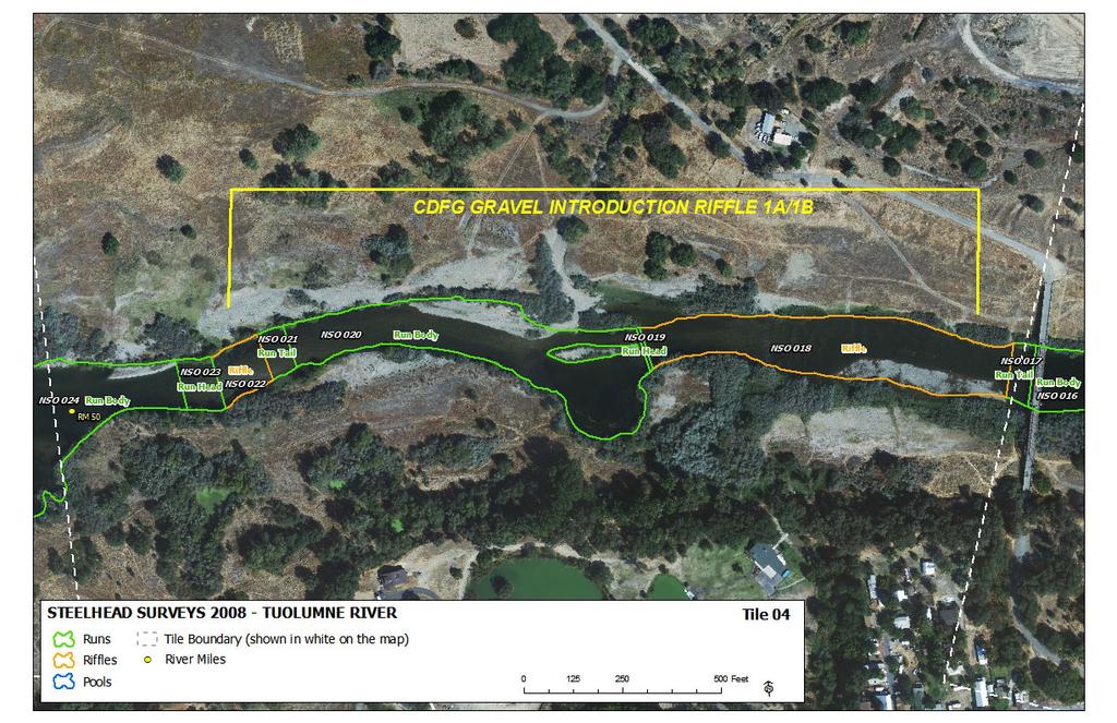
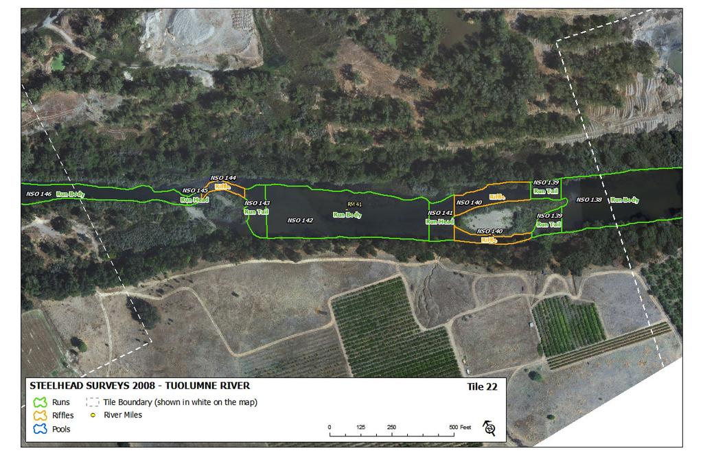
6 Study Plan O. mykiss Population Estimate subsequent population estimates. Habitat units are selected using stratified random sampling where the habitat types possess a pre-determined probability of occurrence within areas where O. mykiss have been frequently observed during the summer in the lower Tuolumne River, extending from approximately river mile (RM) during summers and potentially extending to near the city of Waterford (RM 30) during colder winter conditions. In a typical Phase 1 sampling approach, primary snorkel surveys (Edmundson et al. 1968, Hankin and Reeves 1998, McCain 1992, Dolloff et al. 1996) will be conducted across a subset of all habitat units. In Phase 2, approximately 20 70% of each habitat type sampled will be randomly selected for replicated surveys by either repeated dive counts or depletion electrofishing (Reynolds 1996). Although the bounded counts methodology was developed for use in smaller stream systems (Hankin and Mohr 2001), applying the methodology to a larger system such as the Tuolumne River is feasible provided key assumptions are satisfied. A critical assumption of the bounded counts approach is that all individuals have a chance of being observed. This may not be practically attainable due to the depths of some of the in-channel mining pits and also potentially due to low visibility conditions occurring at downstream locations or due to winter-time sediment inputs during rain events. Hankin and Mohr (2001) found that their survey designs were suitable for coho salmon (O. kisutch), but they were less confident about applying the methodology to O. mykiss juveniles because the fish s furtive nature may violate the assumption that all fish have an observation probability >0. Sampling sites and methods may be modified following initial surveys because local conditions cannot be anticipated and may dictate the use of other schedules, locations, or techniques. Stillwater Sciences will notify TID, FERC, and permitting authorities if substantive changes in the study design, methods or schedule are anticipated. 2.1 Habitat Typing On-the-ground mapping of potential habitat for O. mykiss will be delineated on digital ortho-rectified aerial photographs and information from previous habitat mapping efforts. Appendices A and B shows preliminary habitat units from RM based upon habitat mapping conducted by Stillwater Sciences (2008) between La Grange Dam (RM 52) and Roberts Ferry Bridge (RM 40) (Appendix A) as well as preliminary habitat units from RM 40 to Waterford (RM 30) based upon mapping conducted by McBain & Trush (2004) and EA Engineering (1997) shown in Appendix B. The Appendix B habitat maps will be updated for flow and morphological characteristics in the field in late February and late June in each year. The final habitat maps will delineate all potential O. mykiss habitats according to the major types listed in Table 1, as well as transitional habitats that may be preferentially used by various size classes (i.e., pool heads, pool bodies, pool tails, run heads, run bodies, run tails, and riffles). Table 1. Coarse scale habitat types to be used during snorkel surveys Habitat Description a Approximate Type Depth Riffle Shallow with swift flowing, turbulent water. Partially exposed substrate dominated by cobble or boulder. Gradient moderate (less than 4%). 0 4 ft Run Fairly smooth water surface, low gradient, and few flow obstructions. Mean column velocity generally greater than one foot per second (fts -1 ) ft Pool Slow flowing, tranquil water with mean column water velocity less than 1 fts -1. >10 ft a Major habitat types determined based upon observed hydraulic conditions (McCain 1992, Thomas and Bovee 1993, Cannon and Kennedy 2003) January Stillwater Sciences
7 Study Plan O. mykiss Population Estimate A Geographic Information System (GIS) will be used to update and refine habitat maps prior to thorough field verification of flow, depth, and habitat conditions in the river. Within each reach, individual habitat units will be digitized as two-dimensional features of varying shapes, or polygons, where each unit is a discrete functional habitat, as defined above. This approach is consistent with the general techniques of McCain (1992), Thomas and Bovee (1993), and Cannon and Kennedy (2003) and allows a flexible approach to evaluating habitat and habitat use patterns at a scale that can be easily delineated given available data, readily depicted, and is ecologically meaningful for aquatic species. Habitat units will be assigned a natural sequence order (NSO), starting at one which is the first unit at the upstream end of the site, and a habitat type unit number (1 N pools, runs and riffles). The maximum depth, length and width (usually at 1/3 and 2/3 of the units length) will be recorded and flagging tied at both upstream and downstream ends of units to be surveyed. Pertinent information such as date, unit number, and type is included on the flag. Lastly, the upper and lower end of each unit will be located by GPS and mapping from previous efforts will be verified or updated. 2.2 Sample Site Selection After all potential habitat units are typed and all pertinent information recorded, a subset of each habitat unit type will be selected for single-pass snorkel surveys. Although additional units may be selected at gravel augmentation and other in-channel restoration sites (See Hypothesis 2), selection for sampling proceeds by random selection of the starting sampling unit in the upper survey section, followed by a systematic uniform sampling of the remaining units in the survey reach. For example, every 3 rd, 4 th or larger selection interval will be used to distribute the selected units uniformly across the survey reach. Because the total length of river sampled affects the confidence bounds of the resulting O. mykiss population estimates, at least 10% of the total length of a given habitat type and a minimum of 5 units of each type will be sampled. Based upon preliminary habitat mapping and median unit lengths of various habitat types, Table 2 shows that 63 sampling units for the winter surveys will be selected from representative locations between RM to meet the minimums above. This estimate further assumes that, since detailed habitat type mapping has not been conducted from RM 40 30, habitat type distribution and median length from RM are similar to RM 52 40, as determined by summer 2008 habitat type mapping (Stillwater Sciences 2008). The exact number sampled will be determined after random selection of the habitat units prior to study implementation. During summer, an estimated 35 units will be selected for single-pass snorkel survey from representative locations between RM (Table 2). For both winter and summer surveys, the number and location of habitat units may be adjusted if initial systematic sampling does not allow the study to adequately to test Hypothesis 2. January Stillwater Sciences
8 Study Plan O. mykiss Population Estimate Table 2. Estimated number of sampling units that will meet study design assumption of sampling at least 10% of the total length of a given habitat type. # of units # of units Estimated Estimated Estimated Estimated to be to be Total sampled sampled Habitat total total Median sampled sampled length (ft) Type RM a length (ft) length (ft) length (ft) c Length Length Winter Summer RM b Winter Summer RM RM d 2009 RM d 2009 Riffle 14,320 13,590 27, % 5 11% Pool head , % 5 86% Pool body 6,741 6,795 13, % 5 29% Pool tail , % 5 79% Run head 2,067 1,853 3, % 5 12% Run body 37,350 35,829 73, % 5 11% Run tail 2,393 2,471 4, % 5 11% Total 64,271 61,775 e 126, a From Stillwater Sciences (2008) b Assumes same proportion of habitat types as from RM c Assumes median habitat unit lengths from RM52-40 are proportional to median lengths along RM d Assumes at least 10% of the total length of each habitat type will be sampled; Estimates based upon 10% of the total length of a habitat type by median habitat unit length to determine a minimum number of units e Actual river length from RM January 2009 Stillwater Sciences 6
9 Study Plan O. mykiss Population Estimate 2.3 Sampling Period Winter sampling will begin in late February with systematic random selection of habitat units from RM 52-30, based upon summer 2008 maps (Appendix A) and previous habitat typing between RM (Appendix B). Following habitat selection, Stillwater will use single-pass snorkel surveys and second phase calibration surveys within units of each type to develop uncertainty and bias estimates. Second phase sampling will be conducted using multi-pass snorkel surveys and/or depletion electrofishing methods as allowed under applicable permits (See Section 6). Summer sampling will use habitat maps from RM developed in summer 2008 (Appendix A). Although no additional habitat mapping is anticipated following winter 2009 surveys, habitat unit flagging will be established in advance of each snorkel survey effort and seasonal changes in habitat distribution may force revision of habitat type maps, specifically the upper and lower boundaries of habitat units and/or channel margins, prior to summer 2009 surveys. 2.4 Measurement Parameters and Sampling Methods Multiple parameters will be measured in order to meet the objectives for this study (Table 3). Photos and GPS locations will be taken at each site, and site locations identified on GIS maps corresponding to mapped aquatic habitat units. General site information recorded at fish sampling locations will include site name, GPS coordinates, time, date, and crew member names. In situ water quality parameters (Temperature, dissolved oxygen, and conductivity) will be collected using a precalibrated multi-probe (YSI 85, Yellow Springs Instruments, Yellow Springs, OH). Underwater visibility will also be estimated into the sun and away from the sun using a Secchi disk to monitor any changes in visibility. Dissolved oxygen probes will be recalibrated at each site and checked for accuracy against concentrations measured in Winkler titrations (Grasshoff et al 1983) at the beginning and end of the sampling effort using a dissolved oxygen test kit. January Stillwater Sciences
10 Study Plan O. mykiss Population Estimate Table 3. Measurement parameters and methods for snorkel surveys Parameter Method Metric/Descriptor Natural sequence order (Reach ID Habitat unit #) Latitude/Longitude Habitat Typing Attributes Method Reporting Limit N/A A-1, A-2, A-3, N/A Handheld GPS receiver UTM Habitat type Visual estimation See Table 1 N/A Average unit width Horizontal distance meters (feet) (measured at multiple transects) N/A 3 ft (1 m) Average unit length Horizontal distance meters (feet) 3 ft (1 m) Maximum/minimum depth Vertical distance meters (feet) 1 ft (0.3 m) Bed substrate composition Cover type Visual estimation Visual estimation Field Data During Snorkel Surveys bedrock, boulder, cobble, gravel, organic, sand, silt none, boulder, cobble, IWM, bedrock ledges, overhead vegetation, aquatic vegetation Temperature EPA C 0.1 C Dissolved Oxygen SM 4500-O mg/l 0.0 mg/l Conductivity SM 2510A umhos/cm 1.0 umhos/cm Visibility Secchi depth meters (feet) 0.01 m (0.1 ft) Date/Start time/end time N/A Day/month/year N/A Number of Individuals Visual estimation Number 1 Fish length snorkeling Visual estimation millimeter 50 mm Fish length electrofishing Fork length millimeter 1 mm Weight - electrofishing Electronic balance gram 0.1 g 10% 10% Snorkel Surveys Snorkel surveys will be conducted during daylight hours (7:00am 5:00pm winter; 6:00am 8:00pm summer). A two phase survey design will be used to survey the seven different strata (Table 4). At the first phase, single-pass dive surveys will be conducted by a four to five person crew depending upon river flows and underwater visibility. Sampling units will generally be sampled from downstream to upstream in dive lanes using a zigzag pattern, passing fish and allowing them to escape downstream of the diver. If fish are observed to escape upstream, the diver will take care to avoid counting these fish twice. Divers will record their observations of pertinent attributes (Table 3) and numbers of O. mykiss and Chinook salmon (O. tshawtscha) observed; with fish lengths to be estimated in 50 mm size ranges using a scale model or markings on the slates to correct for underwater size distortion. After the first dive pass is completed a tab is then pulled to determine if the unit is included in the second phase of sampling. January Stillwater Sciences
11 Study Plan O. mykiss Population Estimate Table 4. Preliminary sample unit selection and survey count. Winter 2009 Summer 2009 Phase I Dives Phase II Survey Phase I Dives Phase II Survey Habitat Initial Repeat Initial Repeat Passes Passes Passes Units Units Units Units Passes Riffle Pool head Pool body Pool tail Run head Run body Run tail Total 63 Total 28 Total 35 Total 28 The second phase of sampling collects data that will later be used to extrapolate dive counts to total population estimates by three passes of either repeated dive counts or depletion electrofishing. Ideally, if the count of O. mykiss from the Phase 1 snorkel survey is less than or equal to 20 individuals then three additional dive passes are made. If electrofishing is permitted, all units with a count of juvenile O. mykiss counts greater than 20 individuals will be surveyed by electrofishing. Lastly, occurrence of other native and non-native fish species will be recorded as presence/absence Electrofishing at Riverine Sites If employed during the summer 2009 survey, electrofishing will be conducted by a 4 person crew during the daylight hours (6:00am-8pm) following the dive surveys. Ideally, 3-pass electrofishing will be used on all second phase dive units where the first dive pass exceeded 20 O. mykiss. Dive units that require electrofishing for dive calibration will be completed as soon as possible after the dive survey. Shallow water habitat may be sampled using back pack electrofishing units while deep water habitat may be sampled using a boat electrofishing unit. Back pack electrofishing in shallow waters less than 3 4 ft depth will be conducted using two or more Smith-Root back pack electrofishers (Model LR-24 or Model 12 with 11-inch anode rings and standard rat-tail cathodes). Boat electrofishing may be used in deeper riverine habitats using a boat mounted Smith Root 1.5 KVA electrofishing unit. To ensure the health of all fish captured during electrofishing, all electrofishing will be conducted in accordance with NMFS (2000) electrofishing guidelines and an electrofishing logbook will be maintained and updated at each sampling site. Depending upon river flows and depth, electrofishing will use block nets placed at the upstream and downstream ends of the unit to be fished, taking care to avoid disturbance of the unit during net setup. Block nets will be set up where possible to prevent fish from moving out of the unit. If block nets are not feasible, then a snorkeler may be stationed at the upstream end of a unit to observe any fish moving out of the unit. First pass electrofishing will proceed slowly and deliberately upstream from the downstream end of the unit; members of an electrofishing crew will move to the top and back down to the bottom working closely together. To maintain equal effort on subsequent passes, electrofishing time (seconds) will be recorded to allow for any adjustments in sampling effort. A fourth pass will be conducted if one of the following applies: January Stillwater Sciences
12 Study Plan O. mykiss Population Estimate 1. The number of O. mykiss caught on the 2 nd pass exceeds the number of O. mykiss caught on the 1 st pass. 2. The number of O. mykiss caught on the 3 rd pass is greater than or equal to 25 percent of number caught on the 2 nd pass. The procedure may be modified in riffle habitats to facilitate capture of shocked fish in fast water. In the riffle strata, a pass consists of a sweep from the top to the bottom of the unit. Depending on the water velocity, block nets may or may not be set at the upstream end of riffle units Fish Handling Protocols Any fish captured during electrofishing surveys will be processed, and information collected regarding species identification, fork length (FL, mm), weight (g), and, if applicable, notes on general condition. All fish will be rapidly retrieved using dip nets and placed immediately into aerated live wells or buckets with water. Large fish will be kept separate from juvenile fish to avoid confinement predation. Fish will be identified to species and origin (hatchery or wild stock) where possible. Fish that are weighed and measured will be anesthetized using clove oil to minimize handling stress. After all fish are identified, counted, and measured, fish will be held for approximately 10 minutes, until they show signs of normal swimming patterns and behavior. 2.5 Hypothesis Testing The purpose of the proposed O. mykiss population surveys is to provide population size estimates over several sampling seasons of differing environmental conditions to determine habitat use and needs within the lower Tuolumne River. The surveys will be used to examine the following hypotheses: Hypothesis 1: Summertime distribution of suitable habitat by observed life stages of O. mykiss is related to ambient river water temperature. Hypothesis 2: Habitat use by O. mykiss juveniles and adults observed in the Tuolumne River occurs at the same density in both restored and nearby reference sites. While the selection for sampling proceeds by random selection of the starting sampling unit in the upper survey section, followed by a systematic uniform sampling of the remaining units in the survey reach, additional units adjacent to or near restoration sites may be non-randomly selected to provide treatment and control locations to test Hypothesis 2, especially during winter 2009 surveys when low ambient river water temperatures obviate the need to test Hypothesis Field Work Notification To ensure field staff safety and to satisfy scientific collecting permit requirements, the parties listed in Table 5 will be notified in advance of the proposed sampling in as required to confirm sampling dates. January Stillwater Sciences
13 Table 5. Field Work Notification Study Plan O. mykiss Population Estimate Contact Affiliation Address Phone and Tim Ford TID 333 East Canal Dr. Turlock, CA Tim Heyne CDFG P.O. Box 10 La Grange, CA x1# Jeffery Jahn NMFS 777 Sonoma Ave. Rm 325 Santa Rosa, CA Prior to mobilization, planned river operations by the Districts will be checked to determine if fish sampling would be safe under the anticipated flow and all parties will be notified of any delay or modification to the sampling schedule. 3 QUALITY ASSURANCE The objective of data collection for this Project is to produce data that represent as closely as possible, in situ conditions of the Tuolumne River with respect to river flow conditions, water quality, abundance and habitat use by O. mykiss. To meet this objective, field sampling, sample preparation, and analysis will follow general guidelines outlined in USEPA (2002) by ensuring that: the project's objectives, hypotheses and data quality objectives are identified and agreed upon, the intended measurements and methods are consistent with project objectives, the assessment procedures are sufficient for determining if data of the type and quality needed and expected are obtained, and any potential limitations on the use of the data can be identified and documented. Aquatic environments are inherently variable, but management decisions must be based on a data from a limited number of locations and often collected in short time periods. How well the information collected represent the reach or river-wide fish population depends upon a systematic approach to quality assurance. 3.1 Data Quality Objectives for Measurement Data The data quality parameters used to assess the acceptability of the data are precision, accuracy, representativeness, comparability, and completeness. Precision measures the reproducibility of measurements under a given set of conditions. Analytical precision is limited to water quality and physical habitat characteristics (Table 6). Accuracy is an expression of the degree to which a measured or computed value represents the true value. Field accuracy is controlled by adherence to sample collection procedures. Table 6. Data quality objectives for field parameters Parameter Units Accuracy Precision Completeness Dissolved Oxygen mg/l % 90% Temperature o C % 90% Conductivity umhos/cm + 5% + 5% 90% Depth meters N/A N/A Visibility (Secchi) meters N/A N/A January Stillwater Sciences
14 Study Plan O. mykiss Population Estimate Representativeness expresses the degree to which data accurately and precisely represent an environmental condition. For this study, monitoring site selection will be conducted based on physical habitat attributes. Additionally, specific measurement parameters have been identified as relevant based on numerous studies indicating factors associated with species distribution. Comparability expresses the confidence with which one data set can be evaluated in relation to another data set. For this biological assessment, comparability of data will be established through the use of standard analytical methodologies and reporting formats. The project goal for completeness, a measure of the amount of data that is determined to be valid in proportion to the amount of data collected, will be 90% for analytical water quality parameters. The data quality objective for completeness for all components of this study is 90%. 3.2 Training Requirements/Certification Specialized training is required for the proposed sampling activities, however none of the sampling activities require outside certification from an agency or another entity. Required permits for biological sampling are discussed in Section 5. Field crews will be staffed by a variety of qualified personnel, which due to the nature of extended field activities, will necessarily be rotated in and out of the field. 3.3 Instrument/Equipment Testing, Inspection, and Maintenance Requirements To ensure proper equipment performance in the field, maintenance and operational procedures, including preventative maintenance, will be performed on all YSI multiprobes (temperature, dissolved oxygen, and conductivity). YSI maintenance will be recorded in a logbook with the date the maintenance was performed and the initials of the technician. When the instruments are not deployed, the calibration or storage cup will be used to protect sensors from damage and desiccation. 3.4 Instrument Calibration and Frequency Field probes used for field sampling will be calibrated prior to use, midway through each sampling event, and at the end of each sampling event. Measurement devices for conductivity will be checked against a standard whose source is different than that selected for calibration. Dissolved oxygen will be checked against aerated water whose oxygen content is established by the Winkler method (Grashoff et al 1983). Temperature does not require calibration because of the unvarying nature of the temperature sensor and its conditioning circuitry. 3.5 Reconciliation with Data Quality Objectives If data do not meet the project s specifications, the following actions will be taken. First, the task leaders working with the field crew leaders (in some cases they will be the same person) will review the errors and determine if the problem is equipment failure, calibration/maintenance techniques, or monitoring/sampling techniques. They will suggest corrective action. If the problem cannot be corrected by training, revision of techniques, or replacement of supplies/equipment, then the task leaders will review the data quality objectives (DQOs) and determine if the DQOs are feasible. If the January Stillwater Sciences
15 Study Plan O. mykiss Population Estimate specific DQOs are not achievable, they will determine whether the specific DQO can be relaxed, or if the parameter should be eliminated from the monitoring program. 3.6 Data Management All field data will be amassed in a quality-checked database and summarized. QA checks will be applied to all data before data entry and data will be stored on Stillwater Sciences servers. Full backup of data from all offices is done on a weekly basis, while differential backup (files that have changed since the last full backup) is done on a nightly basis. The backup process is accomplished with a Fast Tape Library and backup processes are completed during off-peak hours. Two sets of tapes are taken offsite by two Information Technology (IT) staff members on a weekly basis to ensure recovery in case of failure or catastrophe. 4 DATA ANALYSIS Data analysis will be conducted to summarize in situ water quality and fish counts in each sampling strata. Bounded counts or depletion estimators will be used to determine populations and linear density for each sampled unit, together with estimates of uncertainty. In addition to comparisons of fish density between sampling strata, the density estimates and uncertainties will be propagated across the unsampled areas for an overall population estimate. Exploratory multiple regression analysis will also be used to determine relationships between fish density and recorded habitat variables. 5 REPORTING A data report will be prepared for use with permitting authorities that includes: date, time, and location of sampling activities; species and number of species collected; and a copy of field data sheets. Results of the winter 2009 surveys will be transmitted to TID electronically within three weeks of the survey completion (April/May 2009). A client review draft of the technical report covering the results of both winter and summer 2009 surveys will be submitted to TID by August 24, Assuming an internal and Agency review comments are received within one and three weeks of issuance of the client review and Agency review drafts, respectively, the Agency review draft will be available by September 8, 2009 and final report will be complete by October 16, PERMITTING REQUIREMENTS Stillwater Sciences will maintain the following permits to sample fish populations that may be present: NMFS Section 10(a)(1)(A) permit 1282 California Department of Fish and Game individual Scientific Collection Permits. A NMFS Section 10(a)(1)(A) permit 1282 has been obtained and all NMFS guidelines (e.g., notification, data gathering, preservation) will be followed if any Central Valley steelhead are captured. Under that existing NMFS permit, electrofishing is limited to an authorized incidental take of 40 juvenile O. mykiss and the <5% unintentional mortality limit, and no adults. An amendment to the sampling description was submitted to NMFS on June 2, 2008 with increased take limits for handling electrofishing of 100 adults and 200 juveniles at an unintentional mortality rate of <10%. Mr. Jeffrey Jahn of NMFS will be notified at least two weeks prior to applicable sampling to confirm January Stillwater Sciences
16 Study Plan O. mykiss Population Estimate sampling dates and locations. Electrofishing under an amended permit will be suspended in the event that the authorized incidental take limits were exceeded and all subsequent calibration surveys would be made by repeat dive surveys. Annual reporting will be provided to Mr. Jeffrey Jahn of NMFS by March 1, of each year. CDFG Scientific Collecting Permits (SCPs) will be maintained for species potentially present in the project area. CDFG guidelines (e.g., notification, data gathering, and preservation) will be followed if special-status species are captured and the CDFG 24-hr dispatch ( ) will be notified should unrelated events result in fish kills. No intentional mortality or removal of special-status species from the wild is included in this study plan. In the event unintentional mortality occurs beyond the take permit limits, NMFS staff will be contacted within 24 hrs and a fin-clip will be provided to the Salmonid Genetic Repository. CDFG will also be contacted to determine the disposition of the individual specimen and whether the individual may be retained for otolith analysis. January Stillwater Sciences
17 Study Plan O. mykiss Population Estimate 7 REFERENCES Cannon, T.C., and T. Kennedy Snorkel survey of the lower American River Prepared by Fishery Foundation of California, San Francisco for U. S. Fish and Wildlife Service, Central Valley Project Improvement Program,, California. Dolloff, C. A., J. Kershner, and R. Thurow Underwater observation. Pages in B. R. Murphy and D. W. Willis, editors. Fisheries techniques, 2nd edition. American Fisheries Society, Bethesda, Maryland. EA Engineering Tuolumne River GIS Database Report and Map. Prepared for the Turlock Irrigation District and Modesto Irrigation District by EA Engineering. FERC Project No. 2299, 1996 FERC Report, Volume VII, Attachment Edmundson, E.F,.E. Everest, and DW. Chapman Permanence of station in juvenile chinook salmon and steelhead trout. Journal of the Fisheries Research Board of Canada 25(7): Grashoff, K., M. Erhardt, and K. Kremling Methods in Seawater Analysis. 2nd ed. Verlag Chemie, Weinheim. Hankin, D.G. and M. Mohr Improved Two-Phase Survey Designs for Estimation of Fish Abundance in Small Streams. Preprint from David G. Hankin, Department of Fisheries Biology, Humboldt State University, Arcata, CA Hankin, D.G., and G.H. Reeves Estimating total fish abundance and habitat area in small streams based on visual estimation methods. Can. J. Fish. and Aqu. Sci. 45: McCain, M.E Comparison of habitat use and availability for juvenile fall chinook salmon in a tributary of the Smith River, California. FHR Currents. No. 7. USDA Forest Service, Region 5. McBain & Trush Habitat Maps for the upper 15.8 miles of the Gravel Bedded Reach Appendix D In Coarse Sediment Management Plan for the Lower Tuolumne River. Revised Final. Prepared for Tuolumne River Technical Advisory Committee, Turlock and Modesto Irrigation Districts, USFWS Anadromous Fish Restoration Program and the CALFED Bay Delta Authority. Prepared by McBain & Trush, Arcata, CA July 20. Mesick, C., J. McClain, D. Marston, and T. Heyne Draft Limiting Factor Analyses & Recommended Studies for Fail-run Chinook salmon and Rainbow Trout in the Tuolumne River, Attachment 2 to USFWS comments on FERC study plan. Available at the FERC website: Stillwater Sciences July 2008 Population Size Estimate of Oncorhynchus mykiss in the Lower Tuolumne River. Prepared for the Turlock Irrigation District and Modesto Irrigation District by Stillwater Sciences, Berkeley, CA. October TID/MID (Turlock and Modesto Irrigation Districts) Ten Year Summary Report of Turlock Irrigation District and Modesto Irrigation District Pursuant to Article 58 of the License for the Don Pedro Project, No Volume. March. January Stillwater Sciences
18 Study Plan O. mykiss Population Estimate TID/MID Tuolumne River Fisheries Study Plan - Don Pedro Hydroelectric Project (FERC NO. 2299). Prepared by T. Ford, N. Hume, S. Wilcox, and R. Yoshiyama for Turlock Irrigation District and Modesto Irrigation District. July 13. Available at the FERC website: Thomas, J.A., and K.D. Bovee Application and testing of a procedure to evaluate transferability of habitat suitability criteria. Regulated Rivers: Research and Management 8: USEPA (U.S. Environmental Protection Agency) Guidance for Quality Assurance Project Plans EPA QA/G-5. EPA/240/R-02/009. U.S. Environmental Protection Agency, Office of Environmental Information, Washington, DC. December. January Stillwater Sciences
19 Appendix B: 2008 Habitat Maps

20

21

22
23

24

25

26

27

28

29

30

31

32

33

34

35

36

37

38

39

40
41

42

43

44
45 Appendix C: 2004 Habitat Maps
46
47 Coarse Sediment Management Plan for the Lower Tuolumne River APPENDIX D
48
49 Coarse Sediment Management Plan for the Lower Tuolumne River APPENDIX D
50
51 Coarse Sediment Management Plan for the Lower Tuolumne River APPENDIX D
52
53 Coarse Sediment Management Plan for the Lower Tuolumne River APPENDIX D
54
55 Coarse Sediment Management Plan for the Lower Tuolumne River APPENDIX D
56
57 Coarse Sediment Management Plan for the Lower Tuolumne River APPENDIX D
58 Appendix D: Habitat Data
59 Technical Report March and July 2009 Population size estimates of O. mykiss in the Lower Tuolumne River Table D-1. Physical habitat types and dimensions of surveyed areas in the lower Tuolumne River (RM 52 40). Habitat unit (NSO) RM March 2009 survey site Length (ft) Average width (ft) Area (ft 2 ) Average depth (ft) Maximum depth (ft) July 2008 habitat type , Pool head , Pool body , Pool tail Yes , Pool head Yes , Pool body Yes , Pool tail Yes , Riffle , Run head , Run body , Run tail , Pool body , Run body , Run tail Yes , Riffle Yes , Run head Yes , Run body Yes , Run tail , Riffle , Run head , Run body , Run tail Yes , Riffle , Run head , Run body , Run tail , Riffle Yes , Pool head Yes , Pool body Yes , Pool tail , Run head , Run body , Run tail , Riffle , Run head , Run body , Run tail , Riffle , Run head , Run body , Run tail , Riffle D-1
60 Technical Report March and July 2009 Population size estimates of O. mykiss in the Lower Tuolumne River Habitat unit (NSO) RM March 2009 survey site Length (ft) Average width (ft) D-2 Area (ft 2 ) Average depth (ft) Maximum depth (ft) July 2008 habitat type , Run head , Run body , Run tail , Riffle , Run head , Run body , Run tail , Riffle , Run head , Run body , Run tail Yes , Riffle , Pool head , Pool body , Pool tail , Riffle Yes , Run head Yes , Run body Yes , Run tail , Riffle , Run head , Run body , Run tail , Riffle , Run head , Run body , Run tail , Run body , Riffle , Run head , Run body , Run tail , Riffle , Run head , Run body , Run tail , Riffle , Run head , Run body , Pool body Yes , Run head Yes , Run body Yes , Run tail , Riffle
61 Technical Report March and July 2009 Population size estimates of O. mykiss in the Lower Tuolumne River Habitat unit (NSO) RM March 2009 survey site Length (ft) Average width (ft) D-3 Area (ft 2 ) Average depth (ft) Maximum depth (ft) July 2008 habitat type Yes , Pool head Yes , Pool body Yes , Pool tail , Riffle , Run head , Run body Run tail , Riffle , Run head , Run body , Run tail Yes , Riffle Run head , Run body , Run tail , Riffle Run head , Run body , Pool body , Run body , Run tail Yes , Riffle Yes , Run head Yes , Run body Yes , Run tail Yes , Riffle Yes , Pool head Yes , Pool body Yes , Pool tail , Run head , Run body , Run tail Yes , Riffle , Run head , Run body Run tail , Riffle Run head , Run body , Run body , Riffle , Run body , Riffle Run head
62 Technical Report March and July 2009 Population size estimates of O. mykiss in the Lower Tuolumne River Habitat unit (NSO) RM March 2009 survey site Length (ft) Average width (ft) D-4 Area (ft 2 ) Average depth (ft) Maximum depth (ft) July 2008 habitat type , Run body , Run tail , Riffle , Run head , Run body , Run tail , Riffle , Run head , Run body , Run tail , Riffle , Run head , Run body , Run tail , Riffle , Run head , Run body , Run tail , Riffle , Run head , Run body , Run tail , Riffle , Run head , Run body , Run tail , Riffle Yes , Run head Yes , Run body Yes , Run tail Yes , Riffle , Run head , Run body , Run tail , Riffle , Pool head , Pool body , Pool tail Yes , Riffle , Run head , Run body , Pool body , Run head , Run body
63 Technical Report March and July 2009 Population size estimates of O. mykiss in the Lower Tuolumne River Habitat unit (NSO) RM March 2009 survey site Length (ft) Average width (ft) D-5 Area (ft 2 ) Average depth (ft) Maximum depth (ft) July 2008 habitat type , Run tail Yes , Riffle , Run head , Run body , Run tail , Riffle , Run head , Run body , Pool body , Pool tail , Run head , Run body , Run tail , Riffle Yes , Pool head Yes , Pool body Yes , Pool tail , Riffle Yes , Pool head Yes , Pool body Yes , Pool tail , Run head , Run body , Run tail , Riffle , Pool head , Pool body , Pool tail , Riffle , Run head , Run body , Run tail , Riffle , Run head , Run body , Run tail , Riffle , Run head , Run body , Run tail Yes , Pool head Yes , Pool body Yes , Pool tail , Riffle
64 Technical Report March and July 2009 Population size estimates of O. mykiss in the Lower Tuolumne River Habitat unit (NSO) RM March 2009 survey site Length (ft) Average width (ft) D-6 Area (ft 2 ) Average depth (ft) Maximum depth (ft) July 2008 habitat type Yes , Run head Yes , Run body Yes , Run tail , Riffle , Run head , Run body , Run tail , Riffle , Run head , Run body , Run tail , Riffle Yes , Pool head Yes , Pool body Yes , Pool tail , Pool head , Pool body , Pool tail , Riffle , Run head , Run body , Run tail , Riffle , Run head , Run body , Run tail , Riffle , Run head , Run body , Run tail , Riffle , Run head , Run body , Pool body , Pool tail , Riffle , Pool head , Pool body , Run body , Run tail , Riffle Yes , Run head Yes , Run body Yes , Run tail
Final Bull Trout Genetics Monitoring Plan for the Wallowa Falls Hydroelectric Project. (FERC No. P-308) June 2017
 June 2017") Final for the Wallowa Falls Hydroelectric Project (FERC No. P-308) June 2017 Prepared by: Jeremiah Doyle PacifiCorp 825 NE Multnomah Street Portland, OR 97232 June, 2017 Page 1 of 8 Table of Contents 1.0
Final for the Wallowa Falls Hydroelectric Project (FERC No. P-308) June 2017 Prepared by: Jeremiah Doyle PacifiCorp 825 NE Multnomah Street Portland, OR 97232 June, 2017 Page 1 of 8 Table of Contents 1.0
Don Pedro Project Relicensing
 Don Pedro Project Relicensing M ODESTO I RRIGATION D ISTRICT TURLOCK I RRIGATION D ISTRICT FERC PROJECT N O. 2299 Resident Fish in Don Pedro Reservoir Don Pedro Reservoir Fish Stocking (1971-Present) CDFG
Data Report : Russian River Basin Steelhead and Coho Salmon Monitoring Program Pilot Study
 Data Report 1999-1: Russian River Basin Steelhead and Coho Salmon Monitoring Program Pilot Study Sonoma County Water Agency 215 West College Avenue Santa Rosa, California 951 Prepared by David Cook Senior
2007 LOWER TUOLUMNE RIVER ANNUAL REPORT
 UNITED STATES OF AMERICA BEFORE THE FEDERAL ENERGY REGULATORY COMMISSION Turlock Irrigation District ) ) and ) Project No. 2299 ) Modesto Irrigation District ) LOWER TUOLUMNE RIVER ANNUAL REPORT Report
145 FERC 62,070 UNITED STATES OF AMERICA FEDERAL ENERGY REGULATORY COMMISSION
 145 FERC 62,070 UNITED STATES OF AMERICA FEDERAL ENERGY REGULATORY COMMISSION Public Utility District No. 1 of Douglas County, Washington Project No. 2149-163 ORDER APPROVING BULL TROUT STRANDING, ENTRAPMENT,
Final Bull Trout Redd Monitoring Report for the Wallowa Falls Hydroelectric Project
 Final for the Wallowa Falls Hydroelectric Project East Fork Wallowa River barrier to upstream fish migration, photo courtesy of Kendrick Moholt (FERC No. P-308) December 18, 2017 Prepared by: Jeremiah
Tuolumne River Gravel Introduction
 Tuolumne River Gravel Introduction 2000 2003 Tuolumne River La Grange Gravel Addition, Phase II Course Sediment Replenishment Program Tuolumne River Salmonid Habitat Improvement Project River Mile 49.9
Abundance of Steelhead and Coho Salmon in the Lagunitas Creek Drainage, Marin County, California
 scanned for KRIS Abundance of Steelhead and Coho Salmon in the Lagunitas Creek Drainage, Marin County, California Prepared for: Marin Municipal Water District 220 Nellen Drive Corte Madera, California
Big Spring Creek Habitat Enhancement and Fishery Management Plans
 Big Spring Creek Habitat Enhancement and Fishery Management Plans November 5, 2012 Big Spring Events and Activities Center Newville, PA Charlie McGarrell Regional Habitat Biologist Pennsylvania Fish and
Final Fish Salvage & Temporary Tailrace Barrier Report for the Wallowa Falls Hydroelectric Project Tailrace. (FERC No. P-308) December 18, 2017
 December 18, 2017") Final for the Wallowa Falls Hydroelectric Project Tailrace (FERC No. P-308) December 18, 2017 Prepared by: Jeremiah Doyle PacifiCorp 825 NE Multnomah Street Portland, OR 97232 December 18, 2017 Page 1
Final for the Wallowa Falls Hydroelectric Project Tailrace (FERC No. P-308) December 18, 2017 Prepared by: Jeremiah Doyle PacifiCorp 825 NE Multnomah Street Portland, OR 97232 December 18, 2017 Page 1
Final Fish Salvage & Temporary Tailrace Barrier Report for the Wallowa Falls Hydroelectric Project Tailrace. (FERC No. P-308) December 20, 2018
 December 20, 2018") Final Fish Salvage & Temporary Tailrace Barrier Report for the Wallowa Falls Hydroelectric Project Tailrace (FERC No. P-308) December 20, 2018 Prepared by: Jeremiah Doyle PacifiCorp 825 NE Multnomah Street
Final Fish Salvage & Temporary Tailrace Barrier Report for the Wallowa Falls Hydroelectric Project Tailrace (FERC No. P-308) December 20, 2018 Prepared by: Jeremiah Doyle PacifiCorp 825 NE Multnomah Street
Packwood Lake Intake Screen Velocity Test Report for Energy Northwest's Packwood Lake Hydroelectric Project FERC No Lewis County, Washington
 for Energy Northwest's Packwood Lake Hydroelectric Project FERC No. 2244 Lewis County, Washington Submitted to P.O. Box 968 Richland, Washington 99352-0968 Submitted by EES Consulting 1155 North State
STEELHEAD SURVEYS IN OMAK CREEK
 STEELHEAD SURVEYS IN OMAK CREEK 2002 Annual Report Prepared by Chris Fisher John Arterburn Colville Confederated Tribes Fish and Wildlife Department P.O. Box 150 Nespelem, WA 99155 Prepared for Project
Redd Dewatering and Juvenile Salmonid Stranding in the Lower Feather River,
 Redd Dewatering and Juvenile Salmonid Stranding in the Lower Feather River, 2005-2006 Interim Report for NOAA Fisheries Prepared by: California Department of Water Resources Division of Environmental Services
THE CONFEDERATED TRIBES OF THE WARM SPRINGS RESERVATION OF OREGON
 THE CONFEDERATED TRIBES OF THE WARM SPRINGS RESERVATION OF OREGON To: Branch of Natural Resources P.0. Box C, Warm Springs, Oregon 97761 Phone (541) 553-2002/2003 Fax (541) 553-1994 The Independent Science
Steve Hemstrom Sr. Fisheries Biologist Chelan PUD Natural Resources Desk: Cell:
 From: To: Cc: Subject: Date: Attachments: Hemstrom, Steven "Lewis, Stephen" Sokolowski, Rosana 2014 Rocky Reach Bull Trout Report Wednesday, June 18, 2014 3:01:07 PM Final 2014 Rocky Reach Bull Trout Observations
107 FERC 61,282 UNITED STATES OF AMERICA FEDERAL ENERGY REGULATORY COMMISSION
 107 FERC 61,282 UNITED STATES OF AMERICA FEDERAL ENERGY REGULATORY COMMISSION Before Commissioners: Pat Wood, III, Chairman; Nora Mead Brownell, and Joseph T. Kelliher. Public Utility District No. 1 of
Chinook Salmon Spawning Study Russian River Fall 2005
 Chinook Salmon Spawning Study Russian River Fall 2005 Sonoma County Water Agency 2150 West College Avenue Santa Rosa, California 95401 Prepared by David Cook - Senior Environmental Specialist March 27,
Amendment to a Biological Assessment/Evaluation completed for the Coon Creek Land Disposal completed December Grand Valley Ranger District
 Amendment to a Biological Assessment/Evaluation completed for the Coon Creek Land Disposal completed December 2007 Grand Valley Ranger District Grand Mesa, Uncompahgre, Gunnison National Forests Prepared
Smolt Monitoring Protocol at COE Dams On the Lower Snake and Lower Columbia rivers
 Smolt Monitoring Protocol at COE Dams On the Lower Snake and Lower Columbia rivers 1.0 Introduction There are two primary goals of the Smolt Monitoring Program (SMP); to provide realtime data on juvenile
FINAL Fish Salvage Plan for the Wallowa Falls Hydroelectric Project Tailrace. (FERC No. P-308) April 19, 2017
 April 19, 2017") FINAL for the Wallowa Falls Hydroelectric Project Tailrace (FERC No. P-308) April 19, 2017 Prepared by: Jeremiah Doyle PacifiCorp 825 NE Multnomah Street Portland, OR 97232 April 19, 2017 Page 1 of 10
FINAL for the Wallowa Falls Hydroelectric Project Tailrace (FERC No. P-308) April 19, 2017 Prepared by: Jeremiah Doyle PacifiCorp 825 NE Multnomah Street Portland, OR 97232 April 19, 2017 Page 1 of 10
ATTACHMENT F. Minnesota Department of Natural Resources. Marsh Lake Ecosystem Restoration Project
 ATTACHMENT F Minnesota Department of Natural Resources Marsh Lake Ecosystem Restoration Project Mussel Rescue and Translocation Plan for Pomme de Terre River Restoration (Prepared June, 2016) Attachment
Study Update Fish Distribution and Species Composition
 Study Update Fish Distribution and Species Composition Goals and Study Area Gain a better understanding of fish species composition and abundance in waters associated with the Packwood Lake Hydroelectric
Job 1. Title: Estimate abundance of juvenile trout and salmon.
 STUDY PERFORMANCE REPORT State: Michigan Project No.: F-53-R-13 Study No.: 461 Title: Population dynamics of juvenile rainbow trout and coho salmon in Lake Superior tributaries Period Covered: April 1,
The Blue Heron Slough Conservation Bank
 1 The Blue Heron Slough Conservation Bank CONSERVATION BANKING July 19-23, 2010 CASE STUDY SERIES The Blue Heron Slough Conservation Bank (Washington) I. OVERVIEW & BACKGROUND: Location: Snohomish River
Study Update Tailrace Slough Use by Anadromous Salmonids
 Study Update Tailrace Slough Use by Anadromous Salmonids Goals and Objectives Identify what anadromous salmonids use the tailrace slough by: Life Stage (Juvenile, migrating and spawning adults) Timing
REVISED DRAFT HABITAT SUITABILITY CURVES and COHO SALMON and STEELHEAD TROUT. Sawmill Creek Alaska
 REVISED DRAFT HABITAT SUITABILITY CURVES and COHO SALMON and STEELHEAD TROUT Sawmill Creek Alaska Blue Lake Hydroelectric Project, FERC No. 2230, Relicensing Prepared by: City and Borough of Sitka ( City
ACUTE TEMPERATURE TOLERANCE OF JUVENILE CHINOOK SALMON FROM THE MOKELUMNE RIVER
 ACUTE TEMPERATURE TOLERANCE OF JUVENILE CHINOOK SALMON FROM THE MOKELUMNE RIVER Charles H. Hanson, Ph.D. Hanson Environmental, Inc. SUMMARY A series of static acute tests were performed to determine the
2012 Hat Creek Trout Population Estimate
 2012 Hat Creek Trout Population Estimate Michael Dege Introduction In 1972 a section of Hat Creek, Shasta County (from PG&E s Hat Creek Powerhouse #2 to Lake Britton) became one of California s first designated
SECTION F FISH HABITAT CONDITION AND AQUATIC SPECIES DISTRIBUTION
 SECTION F FISH HABITAT CONDITION AND AQUATIC SPECIES DISTRIBUTION INTRODUCTION The fish species currently inhabiting the Gualala River WAU are steelhead trout (Oncorhynchus mykiss), sculpin (Cottus spp.),
Columbia Lake Dam Removal Project
 Columbia Lake Dam Removal Project The Columbia Lake dam located 1/4 mile upstream of the Paulins Kill River's confluence with the Delaware River in Knowlton Township, Warren County has been proposed for
A.23 RIVER LAMPREY (LAMPETRA
 A. RIVER LAMPREY (LAMPETRA AYRESII) A.. Legal and Other Status The river lamprey is a Class (Watch List) California Species of Special Concern (Moyle et al., DFG 0). It has no federal status. A.. Species
STUDY REPORT W&AR-03 RESERVOIR TEMPERATURE MODEL ATTACHMENT B DON PEDRO RESERVOIR BATHYMETRIC STUDY REPORT
 STUDY REPORT W&AR-03 RESERVOIR TEMPERATURE MODEL ATTACHMENT B DON PEDRO RESERVOIR BATHYMETRIC STUDY REPORT DON PEDRO RESERVOIR BATHYMETRIC STUDY REPORT Prepared for: TURLOCK IRRIGATION DISTRICT MODESTO
Summary of the Pilot Assessment of Three Potential Fish Barriers on Battle Creek
 Summary of the Pilot Assessment of Three Potential Fish Barriers on Battle Creek Laurie A. Earley March 2014 U.S. Fish and Wildlife Service, Red Bluff Fish and Wildlife Office 10950 Tyler Road, Red Bluff,
Monitoring of Downstream Fish Passage at Cougar Dam in the South Fork McKenzie River, Oregon February 8, By Greg A.
 Monitoring of Downstream Fish Passage at Cougar Dam in the South Fork McKenzie River, Oregon 1998- February 8, 2 By Greg A. Taylor Oregon Dept. of Fish & Wildlife 315 E. Main Street Springfield, OR 97478
Proposed Habitat Suitability Criteria (HSC) Curves For Application in Habitat Flow Modeling For the Sultan River Instream Flow Study RSP 3
 Curves For Application in Habitat Flow Modeling For the Sultan River Instream Flow Study RSP 3") - - Proposed Habitat Suitability Criteria (HSC) Curves For Application in Habitat Flow Modeling For the Sultan River Instream Flow Study RSP 3 Prepared for: Public Utility District No. 1 of Snohomish County
- - Proposed Habitat Suitability Criteria (HSC) Curves For Application in Habitat Flow Modeling For the Sultan River Instream Flow Study RSP 3 Prepared for: Public Utility District No. 1 of Snohomish County
THREATENED, ENDANGERED, AND SENSITIVE SPECIES 2010 ANNUAL REPORT
 LICENSE ARTICLE 410 THREATENED, ENDANGERED, AND SENSITIVE SPECIES 2010 ANNUAL REPORT REPORTING PERIOD JANUARY 1 DECEMBER 31, 2010 BAKER RIVER HYDROELECTRIC PROJECT FERC No. 2150 Puget Sound Energy Bellevue,
THE OREGON PLAN for. Salmon and Watersheds. Smith River Steelhead and Coho Monitoring Verification Study, Report Number: OPSW-ODFW
 THE OREGON PLAN for Salmon and Watersheds Smith River Steelhead and Coho Monitoring Verification Study, 2007 Report Number: OPSW-ODFW-2009-11 The Oregon Department of Fish and Wildlife prohibits discrimination
M E M O R A N D U M. Garcia and Associates P.O. Box 1268 Tahoe City, CA Phone: (530)
") M E M O R A N D U M Garcia and Associates P.O. Box 1268 Tahoe City, CA 96145 Phone: (530) 363-2008 ichan@garciaandassociates.com TO: Curtis Steitz (PG&E, Environmental Services) FROM: Ian Chan (Aquatic
M E M O R A N D U M Garcia and Associates P.O. Box 1268 Tahoe City, CA 96145 Phone: (530) 363-2008 ichan@garciaandassociates.com TO: Curtis Steitz (PG&E, Environmental Services) FROM: Ian Chan (Aquatic
August 11 Snorkel SCC side channel network (SBA, SCC3) feet 707
 feet 707") Date Survey Type Habitat July 29 Snorkel (reconnaissance) Table 1. Fish use survey schedule 2004 Water temperature 1 (ºC) Estimated Mean visibility 2 discharge 3 (cfs) Mainstem (units #1 42) ND ND 814
Date Survey Type Habitat July 29 Snorkel (reconnaissance) Table 1. Fish use survey schedule 2004 Water temperature 1 (ºC) Estimated Mean visibility 2 discharge 3 (cfs) Mainstem (units #1 42) ND ND 814
STUDY PERFORMANCE REPORT
 STUDY PERFORMANCE REPORT State: Michigan Project No.: F-80-R-4 Study No.: 702 Title: Effects of sediment traps on Michigan river channels Period Covered: October 1, 2002 to September 30, 2003 Study Objectives:
Little Kern Golden Trout Status:
 Little Kern Golden Trout Status: The Little Kern Golden trout (LKGT) was proposed for federal listing as Threatened under the Endangered Species Act (ESA) on September 1, 1977 by the U. S. Fish and Wildlife
Sontek RiverSurveyor Test Plan Prepared by David S. Mueller, OSW February 20, 2004
 Sontek RiverSurveyor Test Plan Prepared by David S. Mueller, OSW February 20, 2004 INTRODUCTION Sontek/YSI has introduced new firmware and software for their RiverSurveyor product line. Firmware changes
Columbia Lake Dam Removal Project
 Columbia Lake Dam Removal Project Major Goals of the Columbia Lake Dam Removal: Reconnect 10 miles of the Paulins Kill River to the Delaware River, restoring natural flow regime and sediment transport.
COLUMBIA LAKE DAM REMOVAL PROJECT
 COLUMBIA LAKE DAM REMOVAL PROJECT Major Goals of the Columbia Lake Dam Removal: Reconnect 10 miles of the Paulins Kill River to the Delaware River, restoring natural flow regime and sediment transport.
Peace River Water Use Plan. Monitoring Program Terms of Reference. GMSMON-1 Peace River Creel Survey
 Peace River Water Use Plan Monitoring Program Terms of Reference GMSMON-1 Peace River Creel Survey April 10, 2008 Terms of Reference for the Peace River Water Use Plan Monitoring Program: Peace River Creel
ASSESSMENT OF THE STATUS OF NESTUCCA RIVER WINTER STEELHEAD
 ASSESSMENT OF THE STATUS OF NESTUCCA RIVER WINTER STEELHEAD Gary Susac and Steve Jacobs Coastal Salmonid Inventory Project Oregon Department of Fish and Wildlife August 21, 2001 INTRODUCTION This report
Aquatic Habitats and Instream Flows at the Carmen-Smith Hydroelectric Project, Upper McKenzie River Basin, Oregon
 Aquatic Habitats and Instream Flows at the Carmen-Smith Hydroelectric Project, Upper McKenzie River Basin, Oregon FINAL REPORT Prepared for Eugene Water & Electric Board Eugene, Oregon Prepared by Stillwater
Manual of Fisheries Survey Methods II: with periodic updates. Chapter 22: Guidelines for Sampling Warmwater Rivers with Rotenone
 Manual of Fisheries Survey Methods II: with periodic updates : Guidelines for Sampling Warmwater Rivers with Rotenone P. W. Seelbach, G. L. Towns, and D. D. Nelson Suggested citation: Seelbach, Paul W.,
MARTINDALE POND Wayne County 2004 Fish Management Report. Christopher C. Long Assistant Fisheries Biologist
 MARTINDALE POND Wayne County 2004 Fish Management Report Christopher C. Long Assistant Fisheries Biologist Fisheries Section Indiana Department of Natural Resources Division of Fish and Wildlife I.G.C.
Tuolumne River O. mykiss Acoustic Tracking Study 2010 Technical Report
 Tuolumne River O. mykiss Acoustic Tracking Study 2010 Technical Report Submitted To: Turlock Irrigation District Modesto Irrigation District Prepared By: Jason Guignard Andrea Fuller FISHBIO Environmental,
State of San Francisco Bay 2011 Appendix O Steelhead Trout Production as an Indicator of Watershed Health
 State of San Francisco Bay 2011 Appendix O Steelhead Trout Production as an Indicator of Watershed Health Gordon Becker and Katherine Smetak, Center for Ecosystem Management and Restoration 290 Introduction
FINAL Caples Lake Fisheries Management Plan. Version 4.0
 FINAL Caples Lake Fisheries Management Plan Version 4.0 August 15, 2008 Purpose The Caples Lake Fisheries Management Plan (Plan) outlines the stocking plan to reestablish a sport fishery in Caples Lake
California Steelhead: Management, Monitoring and Recovery Efforts
 California Steelhead: Management, Monitoring and Recovery Efforts Jonathan Nelson Steelhead Restoration & Management Program Oncorhynchus mykiss irideus California Steelhead Distinct Population Segments
NEVADA DEPARTMENT OF WILDLIFE STATEWIDE FISHERIES MANAGEMENT
 NEVADA DEPARTMENT OF WILDLIFE STATEWIDE FISHERIES MANAGEMENT FEDERAL AID JOB PROGRESS REPORT F-20-50 2014 LAHONTAN CUTTHROAT TROUT STUDY WESTERN REGION NEVADA DEPARTMENT OF WILDLIFE, FISHERIES DIVISION
Youngs Creek Hydroelectric Project (FERC No. P 10359)
") Youngs Creek Hydroelectric Project (FERC No. P 10359) Resident Trout Monitoring Plan Annual Report 2010 Survey and Results of Pre Project Monitoring Prepared by: September 2010 Overview The Public Utility
Youngs Creek Hydroelectric Project (FERC No. P 10359) Resident Trout Monitoring Plan Annual Report 2010 Survey and Results of Pre Project Monitoring Prepared by: September 2010 Overview The Public Utility
c h a p t e r 6 n n n Related to the VAMP
 c h a p t e r 6 n n n Complimentary Studies Related to the VAMP Throughout 27 several fishery studies were conducted to advance the understanding of juvenile salmon abundance and survival in the San Joaquin
LOWER MOKELUMNE RIVER UPSTREAM FISH MIGRATION MONITORING Conducted at Woodbridge Irrigation District Dam August 2014 through July 2015.
 LOWER MOKELUMNE RIVER UPSTREAM FISH MIGRATION MONITORING Conducted at Woodbridge Irrigation District Dam August 2014 through July 2015 August 2015 Casey Del Real and Matt Saldate East Bay Municipal Utility
Susitna-Watana Hydroelectric Project (FERC No ) Salmon Escapement Study Study Plan Section 9.7
 Salmon Escapement Study Study Plan Section 9.7") (FERC No. 14241) Salmon Escapement Study Study Plan Section 9.7 Part D: Supplemental Information to June 2014 Initial Study Report Prepared for Prepared by LGL Alaska Research Associates, Inc. & Alaska
(FERC No. 14241) Salmon Escapement Study Study Plan Section 9.7 Part D: Supplemental Information to June 2014 Initial Study Report Prepared for Prepared by LGL Alaska Research Associates, Inc. & Alaska
WASHINGTON CONSERVATION DISTRICT STANDARD OPERATING PROCEDURE (S.O.P.)
") Page 1 of 18 Water Monitoring Program WASHINGTON CONSERVATION DISTRICT STANDARD OPERATING PROCEDURE (S.O.P.) No. 1 FLOW MONITORING Page 2 of 18 Water Monitoring Program Standard Operating Procedure No.
Page 1 of 18 Water Monitoring Program WASHINGTON CONSERVATION DISTRICT STANDARD OPERATING PROCEDURE (S.O.P.) No. 1 FLOW MONITORING Page 2 of 18 Water Monitoring Program Standard Operating Procedure No.
Trout Unlimited Comments on the Scope of Environmental Impact Statement for the Constitution Pipeline Project, Docket No. PF12-9
 October 9, 2012 Kimberly D. Bose, Secretary Federal Energy Regulatory Commission 888 First Street, NE, Room 1A Washington, DC 20426 RE: Trout Unlimited Comments on the Scope of Environmental Impact Statement
NEVADA DEPARTMENT OF WILDLIFE STATEWIDE FISHERIES MANAGEMENT
 NEVADA DEPARTMENT OF WILDLIFE STATEWIDE FISHERIES MANAGEMENT FEDERAL AID JOB PROGRESS REPORTS F-2-52 216 CHIMNEY RESERVOIR WESTERN REGION NEVADA DEPARTMENT OF WILDLIFE, FISHERIES DIVISION JOB PROGRESS
Santa Paula Creek Watershed Planning Project: Steelhead Habitat and Population Assessment
 Steelhead Habitat and Population Assessment TECHNICAL MEMORANDUM Prepared for Santa Paula Creek Fish Ladder Joint Powers Authority California Department of Fish and Game Prepared by Stillwater Sciences
FISH PASSAGE IMPROVEMENT in California s Watersheds. Assessments & Recommendations by the Fish Passage Forum
 FISH PASSAGE IMPROVEMENT in California s Watersheds Assessments & Recommendations by the Fish Passage Forum FISH PASSAGE IMPROVEMENT in California s Watersheds The mission of the Fish Passage Forum is
TECHNICAL MEMORANDUM
 279 Cousteau Place, Suite 400, Davis, CA 95618 phone 530.756.7550 fax 530.756.7586 TECHNICAL MEMORANDUM DATE: December 13, 2013 TO: FROM: SUBJECT: Steve Boyd, Turlock Irrigation District and Greg Dias,
UC Coho Salmon and Steelhead Monitoring Report: Summer 2016
 UC Coho Salmon and Steelhead Monitoring Report: Summer 2016 Prepared by: Mariska Obedzinski, Nick Bauer, Andrew Bartshire, and Andrew McClary California Sea Grant at University of California January 2017,
Admiralty Inlet Pilot Tidal Project FERC No Appendix C. Derelict Gear Monitoring Plan
 Appendix C Derelict Gear Monitoring Plan ADMIRALTY INLET PILOT TIDAL PROJECT FERC PROJECT NO. 12690 DERELICT GEAR MONITORING PLAN (submitted with the Final Application for a New Pilot Project License)
Study No. 18. Mystic Lake, Montana. PPL Montana 45 Basin Creek Road Butte, Montana 59701
 Study No. 18 Evaluation of the Current Fish Population and Habitat in West Rosebud Creek Downstream from Emerald Lake Mystic Lake Hydroelectric Project FERC No. 2301 Mystic Lake, Montana PPL Montana 45
MINNESOTA DEPARTMENT OF NATURAL RESOURCES DIVISION OF FISHERIES AND WILDLIFE. Gamefish Assessment Report
 Minnesota DNR F-29-R(P) Area F312 February 1, 2013 MINNESOTA DEPARTMENT OF NATURAL RESOURCES DIVISION OF FISHERIES AND WILDLIFE Gamefish Assessment Report Spring Gamefish Assessment on the Mississippi
Backgrounder and Frequently Asked Questions
 Backgrounder and Frequently Asked Questions Who Sent the Letter? The 60-day Notice of Intent to File Suit was sent by Conservation Angler, Wild Fish Conservancy, Snake River Waterkeeper, Friends of the
NEVADA DEPARTMENT OF WILDLIFE STATEWIDE FISHERIES MANAGEMENT FEDERAL AID JOB PROGRESS REPORTS F LAHONTAN CUTTHROAT TROUT EASTERN REGION
 NEVADA DEPARTMENT OF WILDLIFE STATEWIDE FISHERIES MANAGEMENT FEDERAL AID JOB PROGRESS REPORTS F-20-50 2014 LAHONTAN CUTTHROAT TROUT EASTERN REGION NEVADA DEPARTMENT OF WILDLIFE, FISHERIES DIVISION ANNUAL
Hydraulic Modeling of Stream Enhancement Methods
 Hydraulic Modeling of Stream Enhancement Methods Matthew J. Curry John J. Levitsky Abstract Development within watersheds increases the amounts of runoff causing stream erosion and degradation of stream
California Steelhead: Management, Monitoring and Recovery Efforts
 California Steelhead: Management, Monitoring and Recovery Efforts Jonathan Nelson Steelhead Management, Research and Restoration Program Oncorhynchus mykiss irideus California Steelhead - Hot Topics Implementation
Five Counties Salmonid Conservation Program - Fish Passage Design Workshop. February 2013
 Program - Aquatic Organisms and Stream Crossings Ecological Connectivity A watershed is a network of channels that drain a common boundary. Channel characteristics formed by interaction of precipitation,
1998 Willow Creek Downstream Migrant Trap Report. Draft. Prepared By: C. A. Walker. Lower Trinity Ranger District. Six Rivers National Forest
 1998 Willow Creek Downstream Migrant Trap Report Draft Prepared By: C. A. Walker Lower Trinity Ranger District Six Rivers National Forest September 1998 Executive Summary The downstream migrant trap was
Southern Oregon Coastal Cutthroat Trout
 Species Management Unit Description Southern Oregon Coastal Cutthroat Trout The Southern Oregon Coastal Cutthroat Trout SMU includes all populations of cutthroat trout inhabiting ocean tributary streams
FSOC Upstream Fish Passage Guidance Document
 FSOC Upstream Fish Passage Guidance Document STEP 1: Identify species and life stages in need of fish passage STEP 2: Identify fishway options and species applicability STEP 3 Fish passage criteria review
2014 Threatened and Endangered Fish Survey of. East Loon Lake and West Loon Lake. Lake County, Illinois
 2014 Threatened and Endangered Fish Survey of East Loon Lake and West Loon Lake Lake County, Illinois Prepared by Integrated Lakes Management 120 LeBaron St. Waukegan, IL 60085. Chris Ryan Chris Rysso
1. Project Title Bull Trout Habitat Restoration Project Identification Assessment. 3. Identification of problem or opportunity to be addressed
 PROPOSAL FORM - Lewis River Aquatic Fund 1. Project Title Bull Trout Habitat Restoration Project Identification Assessment 2. Project Manager Adam Haspiel USFS Abi Groskopf Mount S. Helens Institute (MSHI)
MINNESOTA FRESHWATER MUSSEL SURVEY AND RELOCATION PROTOCOL
 MINNESOTA FRESHWATER MUSSEL SURVEY AND RELOCATION PROTOCOL Minnesota Department of Natural Resources, Division of Ecological and Water Resources U.S. Fish and Wildlife Service, Twin Cities Field Office
Endangered Species Act and FERC Hydroelectric Projects. Jeff Murphy & Julie Crocker NHA New England Meeting November 16, 2010
 Endangered Species Act and FERC Hydroelectric Projects Jeff Murphy & Julie Crocker NHA New England Meeting November 16, 2010 Shortnose Sturgeon Federally listed as endangered in 1967 Listed under the sole
NEVADA DEPARTMENT OF WILDLIFE STATEWIDE SPORT FISHERIES MANAGEMENT
 NEVADA DEPARTMENT OF WILDLIFE STATEWIDE SPORT FISHERIES MANAGEMENT FEDERAL AID JOB PROGRESS REPORT F-20-49 2013 Urban Sport Fisheries SOUTHERN REGION NEVADA DEPARTMENT OF WILDLIFE, FISHERIES DIVISION ANNUAL
TABLE 1. Riverscape surveys completed in the upper Chehalis River, Newaukum, and Satsop rivers.
 RIVERSCAPE SURVEYS OF IN-STREAM FISH ASSEMBLAGES AND HABITAT IN THE CHEHALIS RIVER Mara Zimmerman and John Winkowski Washington Department of Fish and Wildlife, Fish Program EXECUTIVE SUMMARY Introduction
Union Pacific Railroad
 Input Questions: 404/401 Pre Application Meeting, December 18, 2013, Portland, Oregon 1. What is the project purpose and need? The purpose of the project is to improve the efficiency and average velocity
NEVADA DEPARTMENT OF WILDLIFE STATEWIDE FISHERIES MANAGEMENT
 NEVADA DEPARTMENT OF WILDLIFE STATEWIDE FISHERIES MANAGEMENT FEDERAL AID JOB PROGRESS REPORTS F-20-52 2016 Lake Tahoe Rainbow Trout Study WESTERN REGION NEVADA DEPARTMENT OF WILDLIFE, FISHERIES DIVISION
Appendix F: Ecology F-6 Methodology for Estimating Potential Hydroacoustic Impacts to Abundant Hudson River Fish Species and Shortnose Sturgeon from
 Appendix F: Ecology F-6 Methodology for Estimating Potential Hydroacoustic Impacts to Abundant Hudson River Fish Species and Shortnose Sturgeon from Pile-driving Activities during Construction of the Tappan
Draft Central Valley Salmon and Steelhead Recovery Plan
 Draft Central Valley Salmon and Steelhead Recovery Plan for Sacramento River winter-run Chinook salmon Central Valley spring-run Chinook Salmon Central Valley Steelhead National Marine Fisheries Service
Oregon Hatchery Research Center January 2014 David L. G. Noakes, Professor & Director
 Oregon Hatchery Research Center January 2014 David L. G. Noakes, Professor & Director Research Proposal Homing Homing behavior is a striking feature of the biology of Pacific salmon, and is the basis for
Summer Steelhead Surveys North Fork Trinity River Trinity County, California
 KRIS edition Summer Steelhead Surveys North Fork Trinity River Trinity County, California 1978-1997 By Loren Everest Fishery Biologist Weaverville Ranger District Shasta-Trinity National Forests October
LA GRANGE PROJECT FISH BARRIER ASSESSMENT STUDY REPORT
 LA GRANGE PROJECT FISH BARRIER ASSESSMENT STUDY REPORT LA GRANGE HYDROELECTRIC PROJECT FERC NO. 14581 Prepared for: Turlock Irrigation District Turlock, California Modesto Irrigation District Modesto,
NORTH RIVER FISH KILL PRELIMINARY REPORT 2014 SUMMARY
 NORTH RIVER FISH KILL PRELIMINARY REPORT 2014 SUMMARY A fish kill on Nor River was reported to e 1-800 Environmental emergency number on August 9, 2014. Representatives from e PEI Department of Environment,
Discussion on the Selection of the Recommended Fish Passage Design Discharge
 Discussion on the Selection of the Recommended Fish Passage Design Discharge Introduction The provision of fish passage is a requirement for most proposed culvert and bridge installations in Alberta, depending
SUMMARY OF MOVEMENT AND HABITAT USED BY TAGGED BROOK TROUT IN THE MAIN BRANCH AND NORTH BRANCH AU SABLE RIVER DURING SUMMER Data Submitted to:
 SUMMARY OF MOVEMENT AND HABITAT USED BY TAGGED BROOK TROUT IN THE MAIN BRANCH AND NORTH BRANCH AU SABLE RIVER DURING SUMMER 2014 Data Submitted to: Anglers of the Au Sable Submitted by: Dr. Mark R. Luttenton
New two-lane bridge to replace the existing structure spanning the Maple River just south of the Village s central business district
 New two-lane bridge to replace the existing structure spanning the Maple River just south of the Village s central business district Rehabilitate the old bridge Convert to a nonmotorized trail Restore
Perspectives of a State Director Selective fisheries as a tool in fisheries management and salmon recovery
 Perspectives of a State Director Selective fisheries as a tool in fisheries management and salmon recovery Jeffrey P. Koenings, PhD. Washington Department of Fish and Wildlife American Fisheries Society
Creek Trash Assessment (CTA) Methodology (Demonstration: Mill Run Creek, Cheltenham, Pa.)
 Methodology (Demonstration: Mill Run Creek, Cheltenham, Pa.)") Creek Trash Assessment (CTA) Methodology (Demonstration: Mill Run Creek, Cheltenham, Pa.) Mill Run Creek emerges from a storm sewer in Philadelphia to an open creek in Cheltenham. The Creek downstream
Creek Trash Assessment (CTA) Methodology (Demonstration: Mill Run Creek, Cheltenham, Pa.) Mill Run Creek emerges from a storm sewer in Philadelphia to an open creek in Cheltenham. The Creek downstream
DRAFT TECHNICAL MEMORANDUM
 DRAFT TECHNICAL MEMORANDUM From: File No.: 213.001 Re: Beaux Arts Village Shoreline - 2016 Introduction The Washington Academy of Beaux Arts (WABA) completed shoreline habitat restoration at three locations
State of California The Resources Agency DEPARTMENT OF FISH AND GAME
 State of California The Resources Agency DEPARTMENT OF FISH AND GAME FINAL REPORT SHASTA AND SCOTT RIVER JUVENILE SALMONID OUTMIGRATION MONITORING PROJECT Prepared for the Pacific States Marine Fisheries
Packwood Hydroelectric Project Barrier Analysis December 12, 2006
 Packwood Hydroelectric Project Barrier Analysis December 12, 2006 Study Area Natural barriers to upstream fish passage on Lake Creek at RM 1.03 and RM 1.95 Snyder Creek culvert under the Project tailrace
NEVADA DEPARTMENT OF WILDLIFE STATEWIDE FISHERIES MANAGEMENT
 NEVADA DEPARTMENT OF WILDLIFE STATEWIDE FISHERIES MANAGEMENT FEDERAL AID JOB PROGRESS REPORTS F-20-48 2012 RYE PATCH RESERVOIR WESTERN REGION NEVADA DEPARTMENT OF WILDLIFE, FISHERIES DIVISION JOB PROGRESS