Expe ition. Volume 10 Number 3. Spring 1968
|
|
|
- Ethan Bernard Casey
- 5 years ago
- Views:
Transcription

1 Expe ition Volume 10 Number 3 Spring 1968

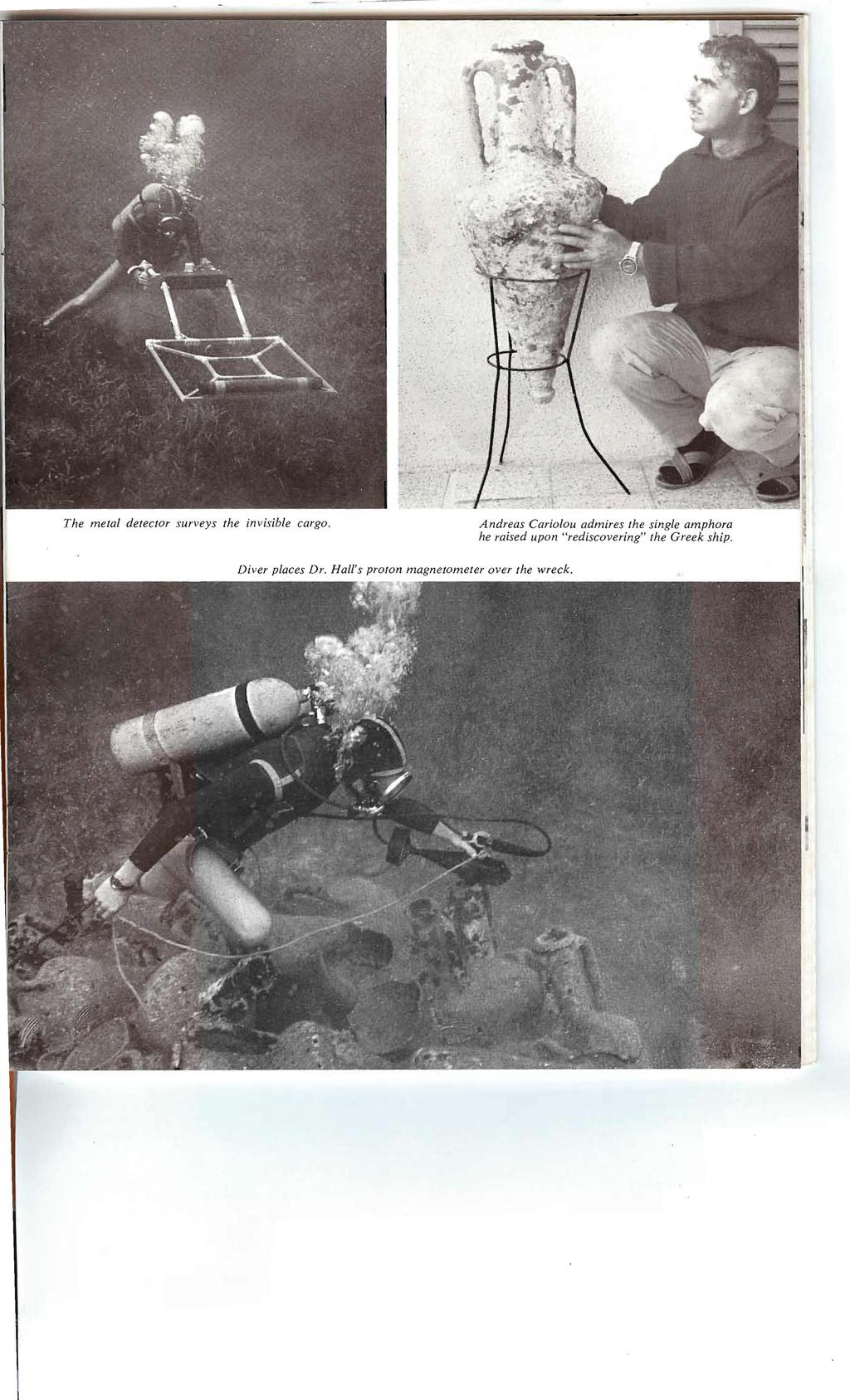
2 By MICHAEL and SUSAN WOMER KATZEV The 1967 survey expedition was made possible through the generous sponsorship of 'he University Museum; the Cyprus Mines Corporation of Los Angeles, whose offices on Cyprus also provided us with assistance in technical, mechanical, and medical problems; the National Geographic Society; the Dietrich Foundation, Inc. of Philadelphia; and the Houghton-Carpenter Foundation, also of Philadelphia. We wish to express thanks for their special assistance to Archbishop Makarios, President of the Republic of Cyprus; Dr. Vassos Karageorghis, Director of the Department of Antiquities; Ambassador Taylor Belcher and his staff of the American Embassy, Nicosia; and Mr. John D. Burgess, General Manager of the Cyprus Division of Cyprus Mines Corporation. Over twenty-two centuries ago a merchant ship sailing the waters off the northern coast of Cyprus somehow came to grief and sank. The reason for her destruction remains buried with her some ninety feet below the surface. Her existence would be still unknown to us had it not been for a most extraordinary day some three years ago. Andreas Cariolou, a diver from the town of Kyrenia, had anchored his boat that day to gather sponges from a deep reef which he had visited many times before. He noticed nothing out of the ordinary as he assembled his diving gear and jumped over the side. In the silence of the sea he descended to the sponge bed and set about prying loose the sponges best in quality and stowing them in his bag. It was some time before he became aware that his anchor was beginning to drag away from the reef, heading toward the flat SPRING,

3 CRETE.. RHODES TURKE.I' CYPRUS CYPRUS o I! MILES sea bed below. He knew that he dare not lose sight of it, for that would likely mean coming to the surface far from his boat. The anchor was moving fast into deep water. The sponger swam after it, just able to keep in sight the wisps of mud it was turning up as it bumped away. As he was straining to match the anchor's pace he caught sight of a mound of shapes unfamiliar to him on the sea bed. Forgetting the anchor, Andreas swam towards the curiosity. He lived then a moment few men will ever know in a diving lifetime. In the sand before him lay a pile of ancient wine jars stacked in neat rows, as on the deck of some ancient merchantman. The diver hovered over the mound to the last minutes of his limited air supply. He broke surface to find himself in the midst of the sudden storm which had just dragged his boat almost half a mile towards shore. He swam for the boat, his diving equipment now a burden in a near gale sea, and in so doing he did not think to take bearings on the spot where the ancient cargo lay. Indeed, he was to spend the next three years searching before he rediscovered the wreck and was able to chart its location. The story is dramatic, and it would be doing it an injustice to tell it in anything less than these terms. Every discovery of a new segment from antiquity is, of course, momentous. But for a diver the sensation must be multiplied, for he moves in an environment to which he is ill-suited. He is not free to stay there long or survey great distances or move at all quickly through the water. It is simply an incredible bit of fortune that brings him upon a deep shipwreck. Three years ago Mr. Cariolou lived an extraordinary day, and it is to the good fortune of the University Museum that he did. When our search team arrived on Cyprus to begin a survey for ancient shipwrecks we heard it rumored that the diver at Kyrenia knew of "some sunken pottery." We had located four shallow wrecks in depths of ten to seventy feet, ranging in date from the Hellenistic to Early Byzantine periods, before the time when we were able to meet with Mr. Cariolou. He agreed to show us something he had just recently refound. With directions as precise as "move the boat twenty feet back and ten feet left," he put our first team of divers directly on the wreck. Mr. Cariolou is an unusual man. He has not only an interest in the antiquity of Cyprus but also an intense concern for the future of his community. He told us much later that few people knew of the wreck's presence, that he had been guarding it against intruders for the time when archaeologists capable of dealing with the find should come to Kyrenia. It had been his fear that weekend divers from the numerous foreign missions on the island might rob the site systematically and disperse the cargo to their own countries. Our director assured him that the Museum team would excavate the ship with care and would preserve its artifacts and the story of its excavation for the town of Kyrenia, hoping to establish there a museum to display the results. We then set ourselves to learn as much as possible from the amphora mound before returning to the Museum to plan its excavation. A curious feature of the site is that the amount of cargo visible is exceedingly small, measuring only ten by sixteen feet. Were we dealing with an ancient "miniature"-perhaps a dingy? We wished to know whether the cargo extended further beneath the sand and, if so, what would be the nature of some of the objects lying in the 12 EXPEDITION
4

5 wreckage. We had for this purpose two metal detecting instruments: the proton magnetometer designed by Dr. E. T. Hall, Oxford, for underwater survey; and a newly developed metal detector devised by Me. Jeremy Green, also from Oxford. Our first task was to layover the wreck site some means of orientation. We fashioned a simple cord grid 10 x 28 meters and divided it into two-meter squares. Being non-metallic, this would not interfere with the metal sensing instruments. Moving across this grid with the proton magnetometer, we located two fairly large concentrations of iron very close to the visible amphora mass. They lie about three feet under the sand. With the metal detector we again located these iron deposits but also charted seven additional concentrations of metallic substance. Having plotted these, we realized that the wreck was indeed larger than the small mound would suggest. Using then a thin metal rod, we systematically probed the surrounding sand to determine the extent of the amphora cargo. It proved to measure approximately 33 x 63 feet, suggesting the size of the vessel below. The distribution of the submerged cargo furthermore showed that the true axis of the wreckage is at some angle to that suggested by the visible mound. Knowing this true axis, we will be able to position a more permanent reference grid with some accuracy once excavation begins. Three different types of amphoras make up the cargo we can see, and these form the basis for our fourth century dating. The predominant type has been dated by Miss Virginia Grace of the American School of Classical Studies at Athens to the last third of the fourth century before Christ. She believes that they were manufactured on Rhodes and indeed stand as the earliest known style of wine jars produced on that island. The origins of the other two types are as yet unknown. The excavation of this wreck beginning in 1968 will add yet another ship to our growing catalogue of merchant vessels. It is, to date, the finest preserved Classical Greek shipwreck yet reported. The fact that it lies on a muddy sand bottom suggests that the wood from the hull remains sufficiently intact to provide us with the material to reconstruct the vessel's hull design. Standing as it does in the 1,700 year span between the Museum's Late Bronze Age shipwreck at Cape Gelidonya and current excavation of a Roman ship at Yassi Ada, it promises to fill an important chapter in our log of seafaring within the ancient Mediterranean world. ~ MICHAEL KATZEV is currently working towards a Ph.D. degree from the University of Pennsylvania in Classical Archaeology. He received his M.A. (1963) from the University of California, Berkeley, in Greek Art History. In 1964 he was a student at the American School of Classical Studies at A thens and participated in their excavation at Nemea, Greece, that spring. He joined the University Muse U/71'S underwater excavations off Yassi Ada, Turkey, in the summer of 1964 and has been a Research Associate in the Museum's Underwater Archaeology Section since SUSAN WOMER KATZEV received her B.A. (1963) in History of Art from Swarthmore College. She has taken part in the underwater excavations of the Museum as staff artist since Currently she is a special assistant to Dr. Bass and her husband in the Underwater Section. Susan and Michael first met in the summer of 1964 while participating in Dr. Bass' excavation of a Byzantine shipwreck off Yassi Ada. 14 EXPEDITION
Exploring the Prinz Eugen Indiana Jones Goes Underwater Lesson Plan
 Exploring the Prinz Eugen Indiana Jones Goes Underwater Lesson Plan Jonathan Bird travels to Kwajalein Atoll in the South Pacific to explore the sunken German Nazi heavy cruiser Prinz Eugen. The Eugen
Underwater excavation of a shipwreck. Bougianen Project (Menorca, Spain)
") Course 049 Underwater excavation of a shipwreck. Bougianen Project (Menorca, Spain) 1. General Information The Sanisera Archaeology Institute for International Field Schools offers annual programs in archaeology.
Course 049 Underwater excavation of a shipwreck. Bougianen Project (Menorca, Spain) 1. General Information The Sanisera Archaeology Institute for International Field Schools offers annual programs in archaeology.
John Broadwater studies the sonar record as it emerges from the sonar recorder.
 Spring 1974 Discovery 73 The American Institute of Nautical Archaeology's first field project, funded mostly by the National Geographic Society, was a survey for ancient shipwrecks off the southwest coast
MAHS Survey of Unidentified Shipwreck Remains on Pickles Reef within the Florida Keys National Marine Sanctuary
 MAHS Survey of Unidentified Shipwreck Remains on Pickles Reef within the Florida Keys National Marine Sanctuary Conducted under Permit FKNMS -2009-054-A1 Key Largo and the FKNMS MAHS was issued a revised
EXPEDITION ADVENTURE PART 2: HIGHER RESOLUTION RANGE SEISMIC IMAGING TO LOCATE A SUNKEN PIRATE SHIP OFF ILE ST MARIE.
 EXPEDITION ADVENTURE PART 2: HIGHER RESOLUTION RANGE SEISMIC IMAGING TO LOCATE A SUNKEN PIRATE SHIP OFF ILE ST MARIE. Jakob B.U. Haldorsen, and Douglas E. Miller, Schlumberger-Doll Research, Ridgefield,
Wind Advisory. March 30, Dr. Stephen D. McConnell. Many of you met a couple years ago a dear pastor friend of mine name Tim.
 1 Wind Advisory March 30, 2014 Dr. Stephen D. McConnell Many of you met a couple years ago a dear pastor friend of mine name Tim. You met him at the point when he was a field worker for the Presbyterian
HMS Colossus Dive Trail
 HMS Colossus Dive Trail HMS Colossus Dive Trail Read this page before the dive HMS Colossus was a 74 gun warship built in 1787 at Gravesend and wrecked in 1798. These 74 gun ships were one of the most
MAHS Field School 2018 Pickles Reef Florida Keys National Marine Sanctuary
 MAHS Field School 2018 Pickles Reef Florida Keys National Marine Sanctuary MAHS returned to Pickles Reef in June of 2018 to hold its annual field school. Pickles Reef lies about 6 miles from Key Largo
CLUE, New Wreck Dive Report
 Cleveland Underwater Explorers (CLUE) is proud to announce the existence of yet another new wreck in Lake Erie off the Cleveland area. This report describes the wreck for the first time, and a tentative
PARTS OF A SHIP. Fore and Aft Rigged Schooner. Square-Rigged Brig. Side-Wheel Steamer. Steam Propeller. Bulk Freighter. Great Lakes Schooner
 PARTS OF A SHIP Pilothouse Porthole Life Boat Steam Propeller STERN Ship s Wheel Cornelia B. Windiate Great Lakes Schooner Site Plan Yawl Boat Mizzen Mast Smoke Stack Bulk Freighter Propeller Deck Planks
WRECK BARON GAUTSCH WRECK DRAGA WRECK HANS SCHMIDT (ISTRA)
") WRECK BARON GAUTSCH Distance from center: 14 NM Maximum depth: 39 meters Minimum depth: 28 meters Length: 89 meters This is an Austrian traveling ship and is the most popular destination in Istria. It
WRECK BARON GAUTSCH Distance from center: 14 NM Maximum depth: 39 meters Minimum depth: 28 meters Length: 89 meters This is an Austrian traveling ship and is the most popular destination in Istria. It
A Remote-sensing Survey of Key West Harbor and Approaches,
 A Remote-sensing Survey of Key West Harbor and Approaches, 2003-2004 Magnetometers Ready to be Deployed, Key West Harbor, December, 2003 Prepared by: Corey Malcom Mel Fisher Maritime Heritage Society 200
Ohio Shipwreck Inventory Data Entry Instructions
 Ohio Shipwreck Inventory Data Entry Instructions VESSEL IDENTIFICATION 1. Vessel Name (required information): Name given to vessel by owner. If vessel name is unknown type Unknown in this field. 2. Name:
Analyzing the Japanese Sailing Ship Model. museum was founded) and 1932 (the year the models were discovered and categorized)
 and 1932 (the year the models were discovered and categorized)") Miles McCollum Anthro 1218 Professor Damian 11 March 2016 Analyzing the Japanese Sailing Ship Model Arriving at the Peabody Museum at Harvard University between 1867 (the year the museum was founded) and
Miles McCollum Anthro 1218 Professor Damian 11 March 2016 Analyzing the Japanese Sailing Ship Model Arriving at the Peabody Museum at Harvard University between 1867 (the year the museum was founded) and
Readiness: Scuba Diving
 Readiness: Scuba Diving AUTHOR INTENT Scuba diving is a real-world activity where each diver has to be responsible for their own safety. The safety of the divers relies on mathematics. The math reviewed
MARINE ANTIQUITIES SCHEME
 For more information on the Marine Antiquities Scheme visit www.marinefinds.org.uk The MAS support team Wessex Archaeology Portway House Old Sarum Park Salisbury SP4 6EB T: 01722 326867 E: mas@wessexarch.co.uk
Telemark 2012: In Search of Dalen s Submerged History
 Telemark 2012: In Search of Dalen s Submerged History Dalen Dalen is a small town at the start of the Telemark waterway. The population is approximately 800. We worked here Planning For hundreds of years,
UNDERWATER ARCHAEOLOGY Pickles Reef Florida Keys National Marine Sanctuary
 UNDERWATER ARCHAEOLOGY Pickles Reef Florida Keys National Marine Sanctuary MAHS Survey and Field School 2011 MAHS returned to Florida in June of 2011 to continue a survey of Pickles Reef begun in 2010.
--The First Stage-- October monthly meeting- Wednesday the 13 th, 7pm, at the Pacific Club. Remember to wear any dive shirt for extra points!
 Kwajalein Scuba Club, October 2010 --The First Stage-- Due to ongoing technical issues last month, there was no photo contest at last month s meeting. So, we will simply have three photo contests at the
Nautical Chart Challenge
 Discover Your World With NOAA Nautical Chart Challenge For as long as anyone in his family could remember, Francis Beaufort wanted to make scientific observations from the deck of a ship. In 1789 at the
Rocks, Wrecks, Obstructions, Aquaculture K
 General 1 Danger line: A danger line draws attention to a danger which would not stand out clearly enough if represented solely by its symbol (e.g. isolated rock) or delimits an area containing numerous
Installation, Compensation and Maintenance Instructions for. RITCHIE Compasses. Made In U.S.A
 Installation, Compensation and Maintenance Instructions for RITCHIE Compasses Made In U.S.A All Magnetic Compasses are vulnerable to magnetic interference, which will produce errors, called deviation.
Jane C. Waldbaum Archaeological Field School Scholarship Field Report
 Jane C. Waldbaum Archaeological Field School Scholarship Field Report Due to the extreme generosity of the Archaeological Institute of America in awarding me a Jane C. Waldbaum Archaeological Field School
Between East and West The Phoenician Shipwreck off Gozo
 Between East and West The Phoenician Shipwreck off Gozo Season Report Dr Timmy Gambin Department of Classics & Archaeology University of Malta October 2017 Preamble Research on the Phoenician shipwreck
The X-craft secret to D-Day revealed: Submariners who led invasion after spending FIVE DAYS on seabed just yards from Nazi guns
 Read more: http://www.dailymail.co.uk/news/article-2015984/honours-submariners-ledsecret-d-day-invasion.html#ixzz1bnmnpg4s The X-craft secret to D-Day revealed: Submariners who led invasion after spending
State of the Art Mapping of Portland Harbour - August 2004
 State of the Art Mapping of Portland Harbour - August 2004 In 2003 and 2004, as part of the "Diving with a Purpose" initiative the Nautical Archaeology Society mapped some of the wrecks in and around Portland
When Admiral Tryon gave
 By Vic Verlinden When Admiral Tryon gave the order that positioned both mighty war vessels Victoria and Camperdown on a collision course, he made a huge mistake. So huge that it cost the lives of more
EXPLORE THE DEEP SUBMERSIBLE PRODUCT OVERVIEW
 EXPLORE THE DEEP SUBMERSIBLE PRODUCT OVERVIEW A NEW HORIZON For centuries, mankind has explored and conquered the surface of the world s oceans. In more recent times we have started to unmask the mysteries
v.36f, no Circuit Court, S. D. New York. October 15, THE NEWPORT. HATCH ET AL. V. THE NEWPORT, (NEW YORK & C. S. S. CO., CLAIMANT.
 YesWeScan: The FEDERAL REPORTER THE NEWPORT. v.36f, no.14-58 HATCH ET AL. V. THE NEWPORT, (NEW YORK & C. S. S. CO., CLAIMANT.) Circuit Court, S. D. New York. October 15, 1888. COLLISION EVIDENCE SUFFICIENCY
Note that this arming distance is not affected by the speed setting of your torpedoes.
 Torpedoes From SilentHunterIII Community Manual Range The minimum (arming) range for the torpedoes in SH3 is officially stated as 300m. However, some [subsim.com (http://www.subsim.com)] forum members
An Example of Adaptive Ship Construction: Examining the Vinta in Its Geographic Context
 Jacob Bradt Anthro1218 Museum Project: Pt. III An Example of Adaptive Ship Construction: Examining the Vinta in Its Geographic Context To analyze the construction of the Peabody Museum s model of a vinta,
Lake Ontario Historic Shipwrecks
 EXPEDITION REPORT Lake Ontario Historic Shipwrecks May 1 October 31, 2016 The Explorers Club Flag # 202 Purpose: To research, locate, and document the undiscovered historic ships in Lake Ontario. Background:
Lake Ontario Historic Shipwrecks
 EXPEDITION REPORT Lake Ontario Historic Shipwrecks May 1 October 31, 2014 The Explorers Club Flag # 202 Purpose: To research, locate, and document the undiscovered historic ships in Lake Ontario. Background:
6. SS RICHARD MONTGOMERY 6.1 INTRODUCTION The purpose of this chapter is to describe the assessment of the extent to which the construction and
 6. SS RICHARD MONTGOMERY 6.1 INTRODUCTION The purpose of this chapter is to describe assessment of extent to which construction operation of a new hub airport in inner Thames Estuary could impact upon
Your web browser (Safari 7) is out of date. For more security, comfort and the best experience on this site: Update your browser Ignore
 is out of date. For more security, comfort and the best experience on this site: Update your browser Ignore") Your web browser (Safari 7) is out of date. For more security, comfort and the best experience on this site: Update your browser Ignore TIDAL BO RE For the complete encyclopedic entry with media resources,
Your web browser (Safari 7) is out of date. For more security, comfort and the best experience on this site: Update your browser Ignore TIDAL BO RE For the complete encyclopedic entry with media resources,
Properties of the Deep Sea
 Properties of the Deep Sea Key Concepts 1. Internal and external pressure must be balanced for an object to retain its shape. 2. Objects may reflect light, absorb light, or let light pass through; the
Navigation with Leeway
 Navigation with Leeway Leeway, as we shall use the term, means how much a vessel is pushed downwind of its intended course when navigating in the presence of wind. To varying extents, knowledge of this
Engineering Surveying - II CE313. Hydrographic Survey Lecture 06 Muhammad Noman
 Engineering Surveying - II CE313 Hydrographic Survey Lecture 06 Muhammad Noman Hydrographic Surveying Hydrographic surveying is the branch of the survey which deal with any body of still or running water
Vieques Underwater Demonstration Project
 Vieques Underwater Demonstration Project NOAA Office of Response and Restoration National Ocean Service 2006-2007 2007 University of New Hampshire Joint Hydrographic Center 2006 Science Application International
Survey Technique for Underwater Digital Photography with Integrated GPS Location Data
 Survey Technique for Underwater Digital Photography with Integrated GPS Location Data Tim Siwiec: United States Environmental Protection Agency Abstract This survey technique is an inexpensive method of
I Can Survive This Storm
 I Can Survive This Storm Pastor Eddie Turner Sunday, June 12, 2016 Mark 4:35-41(NLT) - 35 As evening came, Jesus said to his disciples, Let s cross to the other side of the lake. 36 So they took Jesus
EXPLORE THE DEEP SUBMERSIBLES OVERVIEW
 EXPLORE THE DEEP SUBMERSIBLES OVERVIEW A NEW HORIZON For centuries, mankind has explored and conquered the surface of the world s oceans. In more recent times we have started to unmask the mysteries beneath
Shipwrecks of Coron AKITSUSHIMA Sunk on September 24, 1944 by US Task Force 38 Location: Access: Condition:
 Shipwrecks of Coron AKITSUSHIMA One of the few true warships among the Coron wrecks, was the Akitsushima, a Japanese flying boat tender Location: Between Lajo Island and Manglet Island, south of Concepcion
ARGO Incident. Marine Safety Unit Toledo, OH U.S. Coast Guard Sector Detroit, MI Ohio Environmental Protection Agency
 ARGO Incident Marine Safety Unit Toledo, OH U.S. Coast Guard Sector Detroit, MI Ohio Environmental Protection Agency ARGO Background: Built 1911, sunk in 1937 (78 yrs ago), 120ft x 35ft x 12ft with 4 to
1.0 PURPOSE AND NEED
 1.0 PURPOSE AND NEED 1.0 PURPOSE OF AND NEED FOR THE PROPOSED ACTION 1.1 INTRODUCTION The National Environmental Policy Act (NEPA) of 1969, as amended (42 United States Code Section 4321 et seq.); the
EXPLORE THE DEEP SUBMERSIBLES OVERVIEW
 EXPLORE THE DEEP SUBMERSIBLES OVERVIEW A NEW HORIZON For centuries, mankind has explored and conquered the surface of the world s oceans. In more recent times we have started to unmask the mysteries beneath
Charlottetown Marine Terminal Pipeline Decommissioning Project Description
 Charlottetown Marine Terminal Pipeline Decommissioning Project Description 69 Marr Road Unit B Rothesay NB, E2E 3J9 Tel (506) 848-1920 Fax (506) 848-1929 Charlottetown Marine Terminal Pipeline Decommissioning
Red Sea Liveaboard. Welcome to every divers Paradise! Friday 5th - Friday 12th October 2018
 Red Sea Liveaboard Welcome to every divers Paradise! Friday 5th - Friday 12th October 2018 Crystal clear azure waters abundant with marine life and teeming with wrecks, with a warm and sunny backdrop Welcome
With a team of highly qualified divers Vision offers a wide range of services including;
 Commercial Diving Services With a team of highly qualified divers Vision offers a wide range of services including; Civils Diving Services Inspections, Construction and maintenance on bridges, piles, quay
New Jersey Division of Fish and Wildlife. Excerpts from REEF NEWS 1999 OBJECTIVES OF THE REEF PROGRAM. WHAT DO ANGLERS THINK of the REEF PROGRAM?
 New Jersey Division of Fish and Wildlife Excerpts from REEF NEWS 1999 OBJECTIVES OF THE REEF PROGRAM New Jersey's Reef Program is administered by the DEP's Division of Fish and Wildlife. The objectives
3.6 Magnetic surveys. Sampling Time variations Gradiometers Processing. Sampling
 3.6 Magnetic surveys Sampling Time variations Gradiometers Processing Sampling Magnetic surveys can be taken along profiles or, more often, on a grid. The data for a grid is usually taken with fairly frequent
Summary Report. Grounding Twofold Bay. 20 July 2006
 Summary Report Grounding Twofold Bay 20 July 2006 NARRATIVE On the evening of 19 July 2006, the Skipper of Twofold Bay brought the vessel into Whangawehi Roads on the north coast of the Mahia Peninsula
Chapter 1. The Science of Marine Biology - Why is it important? Marine Biology. The scientific study of the organisms that live in the sea
 Chapter 1 The Science of Marine Biology - Why is it important? Marine Biology Marine Biology - The scientific study of the organisms that live in the sea 1 Practical Reasons to study marine biology Vast
FIGURE 1. TOTAL LENGTH OF FISH, IN THIS CASE A PILE PERCH, IS MEASURED FROM MOUTH TO TIP OF TAIL (ILLUSTRATION LARRY G. ALLEN).
.") Fish Transect Updates- 2013 Sizing Fish Before discussing how to size fish underwater, we must have a picture of what we are measuring. For the purposes of Reef Check California, we will be measuring total
Fish Transect Updates- 2013 Sizing Fish Before discussing how to size fish underwater, we must have a picture of what we are measuring. For the purposes of Reef Check California, we will be measuring total
History/Explorers/Expeditions/Technology Webquest!
 Name Block History/Explorers/Expeditions/Technology Webquest! http://www.divediscover.whoi.edu/history-ocean/21st.html Click on: History of Oceanography (on the left side of the page) 1. Oceanography may
Telling a Fisherman How to Fish. He probably learned his skills from his father, John. So we can suppose that he had fished most of his life.
 Telling a Fisherman How to Fish Luke 5:1-11 Peter was a fisherman. And very likely a good one. He probably learned his skills from his father, John. So we can suppose that he had fished most of his life.
Underwater Archeology off the cost of Magna Graecia
 3-17 June 2012, Praia a Mare - San Nicola Arcella, Italy The Association ETRURIA NOVA ONLUS and Pro-Loco Praia a Mare and San Nicola Arcella, in collaboration with DEEP INSIDE DIVING CENTER and GIANO SNC,
New Millennium Dive Expeditions
 New Millennium Dive Expeditions 15030 N Timberline Drive Reno, NV 89511 (775)850-2510 * nmde@att.net www.nmde.org Project Report July 12, 2013: Phase 1 of 2 (Phase 2: August 26 th 30 th, 2013) Supporting
Perth Schooner Sarah MacDonad
 The Purton Hulks Phase 1 Report No 33 Perth Schooner Sarah MacDonad The Friends of Purton Compiled 1 st March 2010 - 2 - Contents 1.1 Vessel identification page 5 1.2 Photographic comparison page 6 1.2.1
ROMAN MANCETTER. CBA West Midlands Summer Field Day. in conjunction with Atherstone Civic Society
 ROMAN MANCETTER CBA West Midlands Summer Field Day in conjunction with Atherstone Civic Society An introduction to the day from Margaret Hughes, ACS committee member ROMANCETTER No, that s not a typo,
Artificial Reef Uses. Mitigation Shore Protection Scientific Studies Habitat Creation Conservation Economic Stimulus Diver Attractions
 Artificial Reef Uses Mitigation Shore Protection Scientific Studies Habitat Creation Conservation Economic Stimulus Diver Attractions Barbados Study The Relationship between Diver Experience Levels and
2014 Global Underwater Discovery
 2014 Global Underwater Discovery The oceans make up 70% of the Earth's surface, yet our knowledge of the biodiversity and functioning of marine ecosystems is relatively scarce. A new relationship between
Plot the Path. Mary Anne Otten. lesson three
 Plot the Path Mary Anne Otten lesson three Subject/Grade: Grade 2, Math, Social Studies, Science Duration: one class period Materials needed: Per class: Day the Great Lakes Drained Away by Charles Ferguson
FINAL REPORT DERELICT FISHING GEAR REMOVAL PROJECT PORT GARDNER
 1900 W. NICKERSON, STE. 207 SEATTLE, WASHINGTON 98119-1650, U.S.A. TELEPHONE: (206) 285-3480 TELEFAX: (206) 283-8263 E-Mail : jjune@nrccorp.com (corporate) FINAL REPORT DERELICT FISHING GEAR REMOVAL PROJECT
STUDYING THE BOOK OF ACTS IN SMALL GROUP DISCUSSIONS
 STUDYING THE BOOK OF ACTS IN SMALL GROUP DISCUSSIONS Lesson 67 - Paul Sails for Rome - Acts 27:1-12 Read the following verses in the Last Days Bible or a translation of your choice. Then discuss the questions
Anchoring Is Important
 BCC Sailing Classes - Third Theory Anchoring Anchoring Is Important 1 The Anchor is your last resort. Anchoring Keep off a lee shore. Needs to be shaped (type of anchor) to bury in the type of bottom for
Chemistry for the gifted and talented 13
 Chemistry for the gifted and talented 13 Rusting Class discussion (teacher-led) from a PowerPoint presentation: CDROM index 07CD There is no student worksheet for this activity. Discussion of answers:
CARLETON ISLAND UNDERWATER ARCHAEOLOGY PROJECT SUGGESTED APPROACH
 CARLETON ISLAND UNDERWATER ARCHAEOLOGY PROJECT SUGGESTED APPROACH - 1 - CARLETON ISLAND UNDERWATER ARCHAEOLOGY PROJECT SUGGESTED APPROACH SITE: Sunken remains of a wooden sailing vessel, probably late
New Jersey Division of Fish, Game and Wildlife Excerpts from REEF NEWS 1998
 New Jersey Division of Fish, Game and Wildlife Excerpts from REEF NEWS 1998 OBJECTIVES OF THE REEF PROGRAM New Jersey's Reef Program is administered by the DEP's Division of Fish, Game and Wildlife. The
S0300-A6-MAN-010 CHAPTER 2 STABILITY
 CHAPTER 2 STABILITY 2-1 INTRODUCTION This chapter discusses the stability of intact ships and how basic stability calculations are made. Definitions of the state of equilibrium and the quality of stability
marine sanctuary 1 of 5
 This website would like to remind you: Your browser (Apple Safari 4) is out of date. Update your browser for more security, comfort and the best experience on this site. Encyclopedic Entry marine sanctuary
Ontario Underwater Council 2006 Report on Scuba-Diving Related Fatalities in Ontario
 Ontario Underwater Council 2006 Report on Scuba-Diving Related Fatalities in Ontario Compiled by Ron Irvine, Director, Sport Safety, Ontario Underwater Council Foreword: This report has been created to
REPORT OF INITIAL SURVEY OF AN UNKNOWN BARGE OFF OF CEDAR POINT, SANDUSKY, OHIO. July 26-27, Submitted to Cleveland Underwater Explorers, Inc.
 REPORT OF INITIAL SURVEY OF AN UNKNOWN BARGE OFF OF CEDAR POINT, SANDUSKY, OHIO July 26-27, 2008 Submitted to Cleveland Underwater Explorers, Inc. By Jack Papes SUBJECT Report of Initial survey of an unknown
Scout Skills Compass INFORMATION SHEET
 Scout Skills Compass 0845 300 1818 INFORMATION SHEET A compass is an instrument with a magnetised needle which points to (magnetic) north and is therefore used for determining direction. They come in different
Bezaisen: A Symbol of Feudal Era Japan. The Edo Period ( ) was a period of Japanese history characterized by strict
 was a period of Japanese history characterized by strict") Kathy Tran ANTHRO1218: Shipwrecks and Seafarers, Piracy and Plundering Bezaisen: A Symbol of Feudal Era Japan The Edo Period (1603-1868) was a period of Japanese history characterized by strict isolationist
Kathy Tran ANTHRO1218: Shipwrecks and Seafarers, Piracy and Plundering Bezaisen: A Symbol of Feudal Era Japan The Edo Period (1603-1868) was a period of Japanese history characterized by strict isolationist
MicroROV Technology Helps in USS Arizona Preservation By: Bob Christ, VideoRay LLC
 MicroROV Technology Helps in USS Arizona Preservation By: Bob Christ, VideoRay LLC Abstract ROVs are forging ahead in fragile and hazardous even sacred environments that divers dare not tread. The 8-pound
Instructor Development News September/October Edition 2012
 Instructor Development News September/October Edition 2012 Bridging the Gap Dive Theory and the PADI Divemaster Program The last iteration of the PADI Divemaster program included a revision to the PADI
ANTH318 Nautical Archaeology of the Americas
 ANTH318 Nautical Archaeology of the Americas Class 14 Sea Venture, 1609 Left Plymouth, England, on June 7 1609 with six other ships and two pinnaces bound for Jamestown. The fleet carried 600 new settlers
4 wild winds AND white water
 94 PoSTcArDS from THe edge 4 wild winds AND white water Above: Being regarded as the most famous lighthouse in the world has meant that eddystone featured extensively on early postcards and you ll see
FINAL REPORT DERELICT FISHING GEAR IDENTIFICATION AND REMOVAL PROJECT PORT SUSAN
 1900 W. NICKERSON, STE. 207 SEATTLE, WASHINGTON 98119-1650, U.S.A. TELEPHONE: (206) 285-3480 TELEFAX: (206) 283-8263 E-Mail : jjune@nrccorp.com (corporate) FINAL REPORT DERELICT FISHING GEAR IDENTIFICATION
AE2 Submarine Expedition VSAG May Meeting
 AE2 Submarine Expedition VSAG May Meeting By Lloyd Borrett www.borrett.id.au Around 55 people attended the VSAG meeting on Thursday, 17 May 2007 to hear Dr Stuart Cannon and Helena Cannon talk about the
Salvaging the past to save the future
 Salvaging the past to save the future 30 MAMMOET WORLD Issue 13 2014 In 1946, the US Army transport ship, the Zalinski, was on its final journey. The vessel had served for almost three decades and all
New Jersey Scuba Diver - Artificial Reefs - Townsends
 Page 1 of 7 Townsends Reef Home & Search Artificial Reefs Contents Top of Page Deepwater Reef Latest News Prev Next Dive Sites Marine Biology Artifacts & Shipwrecks Gear & Training Bay Jack Donna's Star
Dr. Gino Bottino, MD Chairman, Safety at Sea Committee By Direction
 The Officers, Directors and Members of US SAILING are pleased to present the ARTHUR B. HANSON RESCUE MEDAL to PAOLO FREDIANI for the rescue as follows: The conditions that Saturday were extremely rough
Suncoast Treasured Times
 Suncoast Treasured Times Suncoast Research & Recovery Club Newsletter Website: www.srarc.com Volume: 27 Issue: 2 Date: February, 2017 Tom s Tips The Ground Hog saw his shadow and headed back in for 6 more
Your web browser (Safari 7) is out of date. For more security, comfort and the best experience on this site: Update your browser Ignore
 is out of date. For more security, comfort and the best experience on this site: Update your browser Ignore") Your web browser (Safari 7) is out of date. For more security, comfort and the best experience on this site: Update your browser Ignore BATHYSCAPHE For the complete encyclopedic entry with media resources,
Your web browser (Safari 7) is out of date. For more security, comfort and the best experience on this site: Update your browser Ignore BATHYSCAPHE For the complete encyclopedic entry with media resources,
The Hepburn Expedition
 The Hepburn Expedition Be part of the Crime of the Millennium AboutUsuUsUs A Dramatic Disappearance. In 2008, Midlands was transfixed when Hollywood legend and local resident Jacob Bennett seemed to vanish
The Mary Ellis Report. Team 2. The ketch Mary Ellis (official number: ) was constructed in Kircumber, New
 was constructed in Kircumber, New") The Mary Ellis Report Team 2 Historical Background The ketch Mary Ellis (official number: 106163) was constructed in Kircumber, New South Wales in 1987 by George Frost. Recorded dimensions for the vessel
The Mary Ellis Report Team 2 Historical Background The ketch Mary Ellis (official number: 106163) was constructed in Kircumber, New South Wales in 1987 by George Frost. Recorded dimensions for the vessel
Quantification of trawl damage to premodern shipwreck sites: Case studies from the Aegean and Black Seas
 UNESCO SCIENTIFIC COLLOQUIUM ON FACTORS IMPACTING THE UNDERWATER CULTURAL HERITAGE 10 th Anniversary of the Convention on the Protection of the Underwater Cultural Heritage Royal Library of Belgium, Brussels,
HOW TO DIG A TEST PIT
 HOW TO DIG A TEST PIT An archaeological test pit is a small 1m by 1m trench dug in a series of layers, or spits, to a depth of approximately 1m. The archaeological materials collected from these layers
TP 11249E SHIP SAFETY STANDARD FOR IN-WATER SURVEYS
 TP 11249E SHIP SAFETY STANDARD FOR IN-WATER SURVEYS Canadian Coast Guard Ship Safety Branch 1992 TP 11249E RECORD OF CHANGES STANDARD FOR IN WATER SURVEYS DATE OF AMENDMENT AMENDMENT NUMBER SECTION AMENDED
Fluids. James H Dann, Ph.D. Say Thanks to the Authors Click (No sign in required)
") Fluids James H Dann, Ph.D. Say Thanks to the Authors Click http://www.ck12.org/saythanks (No sign in required) To access a customizable version of this book, as well as other interactive content, visit
Fluids James H Dann, Ph.D. Say Thanks to the Authors Click http://www.ck12.org/saythanks (No sign in required) To access a customizable version of this book, as well as other interactive content, visit
Utilizing Vessel Based Mobile LiDAR & Bathymetry Survey Techniques for Survey of Four Southern California Breakwaters
 Utilizing Vessel Based Mobile LiDAR & Bathymetry Survey Techniques for Survey of Four Southern California Breakwaters Western Dredging Association: Pacific Chapter September 2012 Insert: Pipe Location
Work and pastimes questionnaire
 Work and pastimes questionnaire Lower Abbey Street Dublin 1 Ireland Telephone 01 704 2000 Fax 01 704 1900 Please read each question carefully before answering and use capital letters throughout. Name of
Stourport motor barge Severn Collier
 The Purton Hulks Phase 1 Report No 21 Stourport motor barge Severn Collier The Friends of Purton Compiled 1 st March 2010 - 2 - Contents 1.1 Vessel identification page 5 1.2 Photographic comparison page
An overview of anchorages used by s/v Field Trip
 Papua New Guinea An overview of anchorages used by s/v Field Trip Mark Silverstein - January 9, 218 Mortlock Islands, PNG ANCHORAGES & PROVISIONING 1 Introduction Papua New Guinea can be challenging in
L Jll111I.6 3 = MICROCOPy RESOLUTION TEST CHART L40. NATIONAt TIRFAII nlf qtanpar[os IQ64 A
 RD-RI52 286 EXPLORATORY MAGNETIC SURVEY OF NURRELL'S INLET SOUTH Ido CAROLINA AND PORTION..(U) GULF SOUTH RESEARCH INST BATON ROUGE LA A R SALTUS APR 79 DACNS4-77-C-1139 IE IIIIIIIIIIII UNCLASSIFIED F/G
Sebastian Cermeno ( )
") Sebastian Cermeno (1560-1602) Sebastian Rodriguez Cermeno was a Portuguese adventurer who explored the coast of California for Spain. He was a skilled navigator and had lots of experience sailing across
Sebastian Cermeno (1560-1602) Sebastian Rodriguez Cermeno was a Portuguese adventurer who explored the coast of California for Spain. He was a skilled navigator and had lots of experience sailing across
Day 1 - Departure from Batangas International Port Embarkation time is between 2-4 pm
 Northern Palawan 8D/7N cruise Diving and non-divers itinerary Day 1 - Departure from Batangas International Port Embarkation time is between 2-4 pm Boat Briefing Dinner Day 2 - Apo Reef Apo Reef is regarded
Wrecking barge Petrus
 The Purton Hulks Phase 1 Report No 14 Wrecking barge Petrus The Friends of Purton Compiled 1 st March 2010 - 2 - Contents 1.1 Vessel identification page 5 1.2 Photographic comparison page 6 1.2.1 Historic