DUKC Chart Overlay. Presentation to IHO TWL and DQ Working Groups Wollongong, March 2014
|
|
|
- Beverly Berry
- 5 years ago
- Views:
Transcription
1 DUKC Chart Overlay Presentation to IHO TWL and DQ Working Groups Wollongong, March 2014
2 Outline Who is OMC? DUKC description & methodology. DUKC Chart Overlay concept. Chart Overlay application example. Where to from here...? OMC Wish List


3 Who is OMC International? Provide under-keel clearance advice Inventor and sole supplier of DUKC Installed at 21 Australian, NZ and EU ports

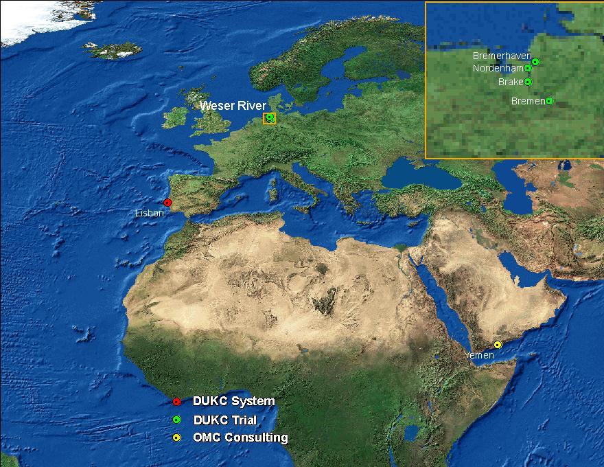

4 DUKC Users
5 What is DUKC? Decision support system for the planning and monitoring of deep draft vessel movements in shallow waters. Provides under keel clearance and sailing advice: On-shore, and On-board Used by: Schedulers / planners VTS officers Mariners (pilots & masters) Regulators

6 What is DUKC? An example
7 Dynamic vs. Static PREDICTED TIDE DRAFT DATUM X % OF DRAFT X MUST ACCOUNT FOR - WAVE RESPONSE - CHANGES IN TIDAL RESIDUAL - SQUAT - SAFETY ALLOWANCES DEPTH
8 DUKC Methodology DUKC Bathymetry Nodes

9 DUKC Methodology predicted waves predicted tide & currents predicted wind & pressure Minimum Keel Elevation latest sounded depths astronomical tides ship in given load state NOTE: Minimum depth anywhere in the DUKC 8 Bathymetry Node ship speed envelopes
10 CHART OVERLAY
11 DUKC Chart Overlay Marine Information Overlay for UKC Shows go and no-go areas ECS dynamic depth contours DUKC Chart Overlay Based on static UKC allowance Based on dynamic UKC calculation Shows live go / no-go Dependant on resolution of ENC bathy Computed on-board Shows predicted go / no-go for ETAs, speeds and conditions along route Uses latest locally-sourced high resolution bathy Computed on-shore and transmitted to vessel

12 Computing the 2D overlay High resolution sounded depths DUKC Bathymetry Nodes 10m x 10m overlay grid Minimum depth Compare DUKC minimum keel elevation to overlay grid cell depth

13 High-resolution bathymetry grid
14 Prototype Chart Overlay on ECS High waves / Low waves Transit Details Passage plan High swell

15 What If Low Waves...? High waves / Low waves Low swell
16 Prototype Chart Overlay on ECS High waves / Low waves High swell

17 Deep-draught transit Bahamas Spirit (Tanker) LBP 247m, Beam 42m Draught 13.9m Place: Port Phillip Bay Date Taken: :04
18 Use in Passage Planning Forecast effect of departure time and transit speed. Hypothetical example in Port of Melbourne. Planning a deep draft tanker movement.

19 What If 14.7m at 16 knts?
20 What If 14.7m at 14 knts?

21 What If 14.7m at 12 knts?
22 Early implementation Initial integration with QPS Qastor ECS. Qastor used by pilots at Melbourne and Port Hedland. Integration not exclusive to Qastor. Deployed to Port Hedland December Web map version under delivery to AMSA for Torres Strait by June On-board trial proposed.
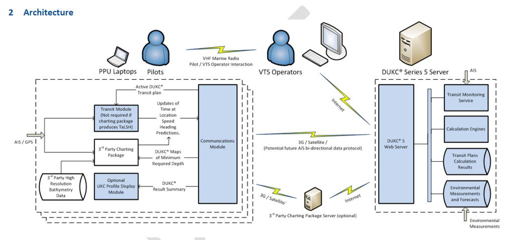
23 System Architecture


24 User feedback Overwhelmingly positive Pilots Assists time-critical decisions in conjunction with shore based support. Invaluable information for emergency situations. Reduces unknowns and allows better-informed decision making. Ports Valuable tool to maximise channel usage Some concern about misuse of the information. Must go hand in hand with operating procedures
25 WHERE TO FROM HERE?
26 Where to from here? Predictive UKC overlay concept has been proved Merge with ongoing e-navigation developments Improve integration and robustness Live UKC?
27 Relevant standards Exchange of: Wave and tide (spatial) forecasts. Vessel passage plan (and updates). High resolution bathymetry data. Datum definitions and separation models
28 E-navigation elements Vessel static and loading details. Vessel dynamic motion models. Ship shore ship data communications. Integration with ECS or ECDIS display software.
29 Design decisions Which calculations on-board? Which calculations on-shore? Low bandwidth communications. Reliability of results (ensuring accurate, up to date input data). Robustness of system to communications or hardware failure. Speed / simplicity / useability of the system. Degree of coordination required with 3 rd party developers.
30 Outstanding issues Custom hardware must be taken on-board (by pilot). Display of time dimension on ECS. Better integration of passage planning with ECS desirable. Transmission and display of space and time varying forecasts. Standard approaches to using high resolution bathymetry data. Relies on 3G phone coverage for updates. Lack of international standard for transmitting UKC data. Possible discrepancy between navigational systems. Lack of fall-back systems.
31 What does OMC need? Specifics Details on data uncertainty: total water depth (depth + tide) Spatial variability (like ZOC) Details on vertical datum and datum relations E.g. CD to WGS84 Example: Real-time UKC measurement through GPS Spatial variations Details on bathymetry: Shoal biased? Rounded? Bed material Tide reduction method applied (to ensure OMC applies same method) Ideally can be queried in CD and WGS84 Ideally an indication of seabed mobility Tide data: Measurement location Vertical datum of measurement Relation to WGS84 ellipsoid At least 2 decimal places Has filtering been applied to provided data? Spatial variation Astronomical predictions Tidal streams (observations and predictions)
32
Underkeel Clearance Management Systems. Captain Jonathon Pearce Senior Pilotage Advisor
 Underkeel Clearance Management Systems Captain Jonathon Pearce Senior Pilotage Advisor Underkeel Clearance Risk Management (UKCM) The management of the touch bottom or grounding hazard Risk = Frequency
The role of UKCM now and the future
 The role of UKCM now and the future NAV18 Torres Strait use case omcinternational.com Who is OMC International? Inventor (1993) and sole supplier of DUKC (>160,000 deep draft transits without incident)
Paper for consideration by ENC Working Group. Use of AU6 ENC cells as an option for Bathymetric ENCs (benc)
") Paper for consideration by ENC Working Group Use of AU6 ENC cells as an option for Bathymetric ENCs (benc) Submitted by: Alvaro Sanchez (AHS) Executive Summary: Compilation of high density bathymetric
Paper for consideration by ENC Working Group Use of AU6 ENC cells as an option for Bathymetric ENCs (benc) Submitted by: Alvaro Sanchez (AHS) Executive Summary: Compilation of high density bathymetric
DUKC DYNAMIC UNDER KEEL CLEARANCE
 DUKC DYNAMIC UNDER KEEL CLEARANCE Information Booklet Prepared in association with Marine Services Department 10/10/2005 Dynamic Under Keel Clearance (DUKC) integrates real time measurement of tides and
Underkeel Clearance. Refresher and changes since EMPA 2015 Lisboa CATZOC s Under-keel clearance methodology
 Underkeel Clearance Refresher and changes since EMPA 2015 Lisboa CATZOC s Under-keel clearance methodology 11 May 2017 Captain Jonathon Pearce Business Development Manager jpearce@omcinternational.com
AHO s experience on HD bathymetric ENCs
 AHO s experience on HD bathymetric ENCs ENCWG3 Wollongong 16 18 April 2018 Alvaro Sanchez DD Charting Quality Assurance, Standards and Specifications Australian Hydrographic Office Background 2016 As part
FULL SCALE MEASUREMENT OF DYNAMIC SHIP MOTIONS AND SQUAT
 FULL SCALE MEASUREMENT OF DYNAMIC SHIP MOTIONS AND SQUAT Mr. Gary Rolph Chief Hydrographic Surveyor Port of Brisbane Corporation Mr. Peter Rumball Surveyor Port of Brisbane Corporation Dr. Terry O'Brien
PORTS AUSTRALIA. PRINCIPLES FOR GATHERING AND PROCESSING HYDROGRAPHIC INFORMATION IN AUSTRALIAN PORTS (Version 1.5 November 2012)
") PORTS AUSTRALIA PRINCIPLES FOR GATHERING AND PROCESSING HYDROGRAPHIC INFORMATION IN AUSTRALIAN PORTS (Version 1.5 November 2012) PREFACE These Principles have been prepared by the Hydrographic Surveyors
PORTS AUSTRALIA PRINCIPLES FOR GATHERING AND PROCESSING HYDROGRAPHIC INFORMATION IN AUSTRALIAN PORTS (Version 1.5 November 2012) PREFACE These Principles have been prepared by the Hydrographic Surveyors
Admiralty e-navigator
 Admiralty e-navigator Admiralty e-navigator Service e-navigation is the harmonised collection, integration, exchange, presentation and analysis of maritime information onboard and ashore by electronic
Paper for Consideration by HSSC8 Development of an Additional Bathymetry Layer standard based on S-57/S-52
 Paper for Consideration by HSSC8 Development of an Additional Bathymetry Layer standard based on S-57/S-52 Submitted by: CIRM, Germany, USA (NOAA) Executive Summary: Proposal for the standardization of
1 st Tidal and Water Level Working Group Meeting DHN, Niteroi, Brazil 31/03/09 02/04/09 Vertical Offshore Reference Framework (VORF) Chris Jones
 Chris Jones") 1 st Tidal and Water Level Working Group Meeting DHN, Niteroi, Brazil 31/03/09 02/04/09 Vertical Offshore Reference Framework (VORF) Chris Jones United Kingdom Hydrographic Office Presentation Structure
1 st Tidal and Water Level Working Group Meeting DHN, Niteroi, Brazil 31/03/09 02/04/09 Vertical Offshore Reference Framework (VORF) Chris Jones United Kingdom Hydrographic Office Presentation Structure
TIME VARYING OBJECTS IN ECDIS Today, tomorrow and soon after
 TIME VARYING OBJECTS IN ECDIS Today, tomorrow and soon after by Bohdan PILLICH 1 Abstract ECDIS is about to become a commercial reality. However, the full potential of the system is not likely to be realised
S-44 edition 5 The IHO s New Standard For Hydrographic Surveys Chris Howlett Head of Seabed Data Centre United Kingdom Hydrographic Office
 S-44 edition 5 The IHO s New Standard For Hydrographic Surveys Chris Howlett Head of Seabed Data Centre United Kingdom Hydrographic Office Chairman of IHO Working Group that created S-44 edition 5 S-44
Outcome of the discussion with other HSSC WG on contribution to the MSP MSP development work
 NIPWG 4-43.1 Submitted by: Executive Summary: Paper for Consideration by NIPWG IMO e-navigation Hydrographic Services Related Documents: HSSC7 (action item 7/35) Related Projects: IMO e-navigation NIPWG
EMPA 2017 How can the S-102 Bathymetric Surface Product improve safety in navigation and pilotage?
 EMPA 2017 How can the S-102 Bathymetric Surface Product improve safety in navigation and pilotage? Operated by the Norwegian Mapping Authority, Hydrographic Service FREEDOM TO CHOOSE Content What is the
Paper 52 The St Lawrence River DUKC System Implementation
 Paper 52 The St Lawrence River DUKC System Implementation TURNER M. and VILLELLA, M. (OMC International, Australia; Pilotage S.A, Argentina) Email (1 st author): m.turner@omcinternational.com ABSTRACT:
HELSINKI COMMISSION HELCOM SAFE NAV 4/2014 Group of Experts on Safety of Navigation Fourth Meeting Helsinki, Finland, 4 February 2014
 HELSINKI COMMISSION HELCOM SAFE NAV 4/2014 Group of Experts on Safety of Navigation Fourth Meeting Helsinki, Finland, 4 February 2014 Agenda Item 3 Accidents and ship traffic in the Baltic Sea Document
GNSS Technology for the Determination of Real-Time Tidal Information
 GNSS Technology for the Determination of Real-Time Tidal Information Benjamin Kidder C-Nav Positioning Solutions European region Outline of Topics Covered Introduction to Tides Past and Present Methods
V Complying with IHO S-52/S-63/S-64
 Model FEA-2107/2807 V.06.50 Complying with IHO S-52/S-63/S-64 The software has been upgraded to V.06.50 in accordance with the IHO standards. IHO S-52 Ed. 6.1.1 Specifications for Chart Contents and Display
14/10/2013' Bathymetric Survey. egm502 seafloor mapping
 egm502 seafloor mapping lecture 10 single-beam echo-sounders Bathymetric Survey Bathymetry is the measurement of water depths - bathymetry is the underwater equivalent of terrestrial topography. A transect
Concept Channel Design & Channel Development Strategy D R A F T. Document Ref: AGH-CEP0-EG-REP-0012
 Concept Channel Design & Channel Development Strategy Document Ref: AGH-CEP0-EG-REP-0012 In May 2016 the Special Minister of State asked Infrastructure Victoria to provide advice on the future capacity
THE CHALLENGES OF A LARGE-AREA BATHYMETRIC SURVEY
 THE CHALLENGES OF A LARGE-AREA BATHYMETRIC SURVEY Agenda: - Introduction - Tender - Project Planning - Survey - Processing - Delivery - Conclusion 2 Introduction We know less of the oceans at our feet,
Activities of KHOA on creation of S-10X test data sets and S-100 sea trial
 Activities of KHOA on creation of S-10X test data sets and S-100 sea trial Submitted by: Executive Summary: Related Documents: Related Projects: Republic Of Korea (KHOA) KHOA has been conducting a research
Marine Renewables Industry Association. Marine Renewables Industry: Requirements for Oceanographic Measurements, Data Processing and Modelling
 Marine Renewables Industry Association Marine Renewables Industry: Requirements for Oceanographic Measurements, Data Processing and Modelling October 2009 Table of Contents 1. Introduction... 1 2. Measurements
New generation of Electronic Card Systems: The 4-D Card
 New generation of Electronic Card Systems: The 4-D Card Capt. Alain Richard Project director Maritime Innovation arichard@imar.ca Context In the present context of globalization and competitiveness, it
Preventing Damage to Harbour Facilities and. Ship Handling in Harbours PART 2 INDEX
 Preventing Damage to Harbour Facilities and Ship Handling in Harbours PART 2 INDEX 1 Vessel handling is based on the basic knowledge that a vessel floats in the water and returns to its original position
Measurement of vertical motions of bulk carriers navigating in port entrance channels
 HYDROGRAPHIC CONFERENCE Technical Awareness Seminar 2007 Cape Town, 19 21 June 2007 Measurement of vertical motions of bulk carriers navigating in port entrance channels J Moes CSIR, PO Box 320, Stellenbosch,
INTERNATIONAL HYDROGRAPHIC ORGANIZATION
 INTERNATIONAL HYDROGRAPHIC ORGANIZATION S-67 MARINERS GUIDE TO ACCURACY OF ELECTRONIC NAVIGATIONAL CHARTS (ENC) Edition 0.5 July 2017 Copyright International Hydrographic Organization 2017 This work is
PROJECT 1 REMOVAL OF WRECKS IN THE TRAFFIC SEPARATION SCHEME IN THE STRAITS OF MALACCA AND SINGAPORE OBJECTIVE. Generally to enhance the safety of
 PROJECT 1 REMOVAL OF WRECKS IN THE TRAFFIC SEPARATION SCHEME IN THE STRAITS OF MALACCA AND SINGAPORE OBJECTIVE Generally to enhance the safety of navigation in the Straits of Malacca and Singapore (Straits)
Figure 1: The squat effect. (Top) Ship at rest. (Bottom) Ship under way.
 Ship at rest. (Bottom) Ship under way.") Under-Keel Clearance of Frigates and Destroyers in Shallow Water Tim Gourlay, Centre for Marine Science and Technology, Curtin University CMST Research Report 013-53 Abstract For RAN ships operating in
Under-Keel Clearance of Frigates and Destroyers in Shallow Water Tim Gourlay, Centre for Marine Science and Technology, Curtin University CMST Research Report 013-53 Abstract For RAN ships operating in
13. TIDES Tidal waters
 Water levels vary in tidal and non-tidal waters: sailors should be aware that the depths shown on the charts do not always represent the actual amount of water under the boat. 13.1 Tidal waters In tidal
Port of Melbourne DUKC Implementation
 Port of Melbourne DUKC Implementation Giles R. Lesser, Matthew R. Turner and Peter W. O Brien OMC International Pty Ltd, Australia Abstract Port Phillip Heads (PPH) is rightly considered one of the most
MARINE NOTICE MARINE NOTICE. Marine Notice 7/2012. Guidance on ECDIS for ships calling at Australian ports 7/2012
 MARINE NOTICE MARINE 7/2012 NOTICE Marine Notice 7/2012 Guidance on ECDIS for ships calling at Australian ports This notice aims to clarify some of the emerging issues relating to the carriage requirements
ECDIS Chart Layers. And. Their Navigational Impact
 ECDIS Chart Layers And Their Navigational Impact 1 ONE COMPANY ONE PARTNER To the benefit of all: Added value from integrated products and services IS Value Chain Partner for the maritime industry 2 SYSTEM
SAFETY OF NAVIGATION OPERATING ANOMALIES IDENTIFIED WITHIN ECDIS
 E 4 ALBERT EMBANKMENT LONDON SE1 7SR Telephone: +44 (0)20 7735 7611 Fax: +44 (0)20 7587 3210 SN.1/Circ.312 9 July 2012 SAFETY OF NAVIGATION OPERATING ANOMALIES IDENTIFIED WITHIN ECDIS 1 The Sub-Committee
ICES Guidelines for Multibeam Echosounder Data (Compiled September 2006)
") ICES Guidelines for Multibeam Echosounder Data (Compiled September 2006) If you are considering producing a hydrographic survey please read the following information first. Your survey could be used to
ICES Guidelines for Multibeam Echosounder Data (Compiled September 2006) If you are considering producing a hydrographic survey please read the following information first. Your survey could be used to
Accommodating Larger Vessels: Ship Maneuverability and Channel Depth; A discussion of vessel motion in shallow water and future research needs.
 Accommodating Larger Vessels: Ship Maneuverability and Channel Depth; A discussion of vessel motion in shallow water and future research needs. PANELISTS: Paul Amos: President, Columbia River Pilots. Larry
: Hydrodynamic input for 2D Vessel Simulations (HY- 0027)
") Technical Note To : Christian Taylor (PoHDA) From : Rohan Hudson Cc : Ben Gray Date : 1/04/2015 (Final Draft) Subject : Hydrodynamic input for 2D Vessel Simulations (HY- 0027) Introduction This Technical
Technical Note To : Christian Taylor (PoHDA) From : Rohan Hudson Cc : Ben Gray Date : 1/04/2015 (Final Draft) Subject : Hydrodynamic input for 2D Vessel Simulations (HY- 0027) Introduction This Technical
International Conference of Advanced Intelligent Maritime Safety and Technology. Original article
 A MAST 2015 International Conference of Advanced Intelligent Maritime Safety and Technology Original article Human Factors in e-navigation: a study of Dynamic NoGo Area Visualization in Electronic Nautical
INTERNATIONAL HYDROGRAPHIC SURVEY STANDARDS
 INTERNATIONAL HYDROGRAPHIC SURVEY STANDARDS by Gerald B. MILLS 1 I. Background The International Hydrographic Organization (IHO) traces its origin to the establishment of the International Hydrographic
Stars and Compass Trophy and Novice Paper 2014!
 Stars and Compass Trophy and Novice Paper 2014 The Stars and Compass Trophy was established to promote the use and development of traditional navigation skills. This year, in a bid to encourage novice
NEED FOR SUPPLEMENTAL BATHYMETRIC SURVEY DATA COLLECTION
 305 West Grand Avenue, Suite 300 Montvale, New Jersey 07645 Phone 201.930.9890 Fax 201.930.9805 www.anchorqea.com M EMORANDUM To: Caroline Kwan and Nica Klaber U.S. Environmental Protection Agency Region
Infrastructure Victoria Second Container Port Advice
 Infrastructure Victoria 4 May 2017 Infrastructure Victoria Second Container Port Advice Navigation Study Revision 0 3 May 2017 Navigation Study Client: Infrastructure Victoria ABN: 83 184 746 995 Prepared
Search Techniques. Contents
 Search Techniques Contents Overview... 2 1. Developing the Search Plan... 2 1.1 Search Planning Sequence... 2 2. Search Terminology... 3 3. Search Patterns... 6 4. Searching and GPS... 8 5. Search Protocols...
TITLE: The Importance of Model Validation: Two Case Studies. AUTHOR:Julie Thomas. Scripps Institution of Oceanography, La Jolla, CA.
 TITLE: The Importance of Model Validation: Two Case Studies AUTHOR:Julie Thomas Scripps Institution of Oceanography, La Jolla, CA jothomas@ucsd.edu CO-AUTHOR: Corey Olfe Scripps Institution of Oceanography,
MARINE NOTICE MARINE NOTICE. Marine Notice 11/2012 Supersedes 15/2010 and 7/2012. Guidance on ECDIS for ships calling at Australian ports 11/2012
 MARINE NOTICE MARINE 11/2012 NOTICE Marine tice 11/2012 Supersedes 15/2010 and 7/2012 Guidance on ECDIS for ships calling at Australian ports This notice aims to clarify some of the emerging issues relating
SOCIEDAD CHILENA DE INGENIERIA HIDRÁULICA V SEMINARIO INTERNACIONAL DE INGENIERÍA Y OPERACIONES PORTUARIAS OCTUBRE 2008, CONCEPCIÓN, CHILE
 UKC management an Australasian perspective. MATTHEW TURNER 1 PETER O BRIEN 2 RESUMEN Historically UKC management in Australia and New Zealand has been based on empirical static rules. Depending on the
Utilizing Vessel Based Mobile LiDAR & Bathymetry Survey Techniques for Survey of Four Southern California Breakwaters
 Utilizing Vessel Based Mobile LiDAR & Bathymetry Survey Techniques for Survey of Four Southern California Breakwaters Western Dredging Association: Pacific Chapter September 2012 Insert: Pipe Location
Study of Passing Ship Effects along a Bank by Delft3D-FLOW and XBeach1
 Study of Passing Ship Effects along a Bank by Delft3D-FLOW and XBeach1 Minggui Zhou 1, Dano Roelvink 2,4, Henk Verheij 3,4 and Han Ligteringen 2,3 1 School of Naval Architecture, Ocean and Civil Engineering,
Understanding the waves at Port Phillip Heads, Melbourne, Australia
 Understanding the waves at Port Phillip Heads, Melbourne, Australia Giles Lesser Matthew Turner David Provis OMC International, Melbourne, Victoria Cardno Lawson Treloar, Melbourne, Victoria Abstract Waves
Introduction. VORF - Model Development and Principles. The required VORF model transformation accuracies were as follows:
 Introduction In 2006, the United Kingdom Hydrographic Office (UKHO) began testing of the Vertical Offshore Reference Frame (VORF), which had been developed on their behalf by the Department of Geomatic
ENVIRONMENT AGENCY GREAT OUSE AND 100 FT DRAIN QUARTERLY BATHYMETRIC SURVEY DECEMBER 2013 SITE SURVEY REPORT NO. H6787
 ENVIRONMENT AGENCY GREAT OUSE AND 100FT DRAIN QUARTERLY BATHYMETRIC SURVEY DECEMBER 2013 NO. H6787 LONGDIN & BROWNING (SURVEYS) LIMITED CHERRY TREE HOUSE CARMARTHEN ROAD SWANSEA SA1 1HE H6787 1 Measured
AN IMPROVED INTEGRATED APPROACH FOR OPTIMISING SHIPPING CHANNEL CAPACITY FOR AUSTRALIAN PORTS
 An Improved Integrated Approach for Optimising Shipping Channel Capacity for Australian Ports 17 S. MORTENSEN, B. JENSEN, A. HARKIN, M. TREE, T. WOMERSLEY AND R. NAVE AN IMPROVED INTEGRATED APPROACH FOR
Beach Wizard: Development of an Operational Nowcast, Short-Term Forecast System for Nearshore Hydrodynamics and Bathymetric Evolution
 Beach Wizard: Development of an Operational Nowcast, Short-Term Forecast System for Nearshore Hydrodynamics and Bathymetric Evolution Ad Reniers Civil Engineering and Geosciences, Delft University of Technology
Chart Specifications of the IHO Publication S-4 (Formerly M-4)
") TWLWG3/4/11A Publication S-4 (Formerly M-4) Attached to this document is an extract from IHO Publication S-4 which relate to Tidal and Water Level Information. The TWLWG is requested to review this information
TWLWG3/4/11A Publication S-4 (Formerly M-4) Attached to this document is an extract from IHO Publication S-4 which relate to Tidal and Water Level Information. The TWLWG is requested to review this information
The Maritime Law Association of Australia and New Zealand
 The Maritime Law Association of Australia and New Zealand Protecting the Environment and Promoting Safe Navigation: Australia s System of Pilotage in the Torres Strait Adam McCarthy Assistant Secretary
Marine Guide for Ship Masters Contents
 Marine Guide for Ship Masters Contents Marine Guide for Ship Masters... 1 Port Operating Company... 2 Harbour Authority... 2 Location... 2 Pilotage... 2 Pilot Boat... 3 Pilot Ladder... 3 Pilots and Tugs
Chittagong, Bangladesh (Asia Region)
") General Information: Port Information (Asia Region) Extract of port information from Chittagong Port Authority: The Port of Chittagong is the principal Port of the People's Republic of Bangladesh. It is
General Information: Port Information (Asia Region) Extract of port information from Chittagong Port Authority: The Port of Chittagong is the principal Port of the People's Republic of Bangladesh. It is
NIGERIAN NOTICES TO MARINERS November 2017 EDITION PUBLISHED BY THE HYDROGRAPHIC OFFICE LAGOS. Notice 01 November 2017 Supplied Gratis
 NIGERIAN NOTICES TO MARINERS November 2017 EDITION PUBLISHED BY THE HYDROGRAPHIC OFFICE LAGOS Notice 01 November 2017 Supplied Gratis November 2017 CONTENTS I II Explanatory Notes and Index Nigerian Navy
Wheatstone Marine Operations - Pilotage - Passage Plan - Onslow Port Limit to WMT
 Wheatstone Marine Operations - Pilotage - Passage Plan - Onslow Port Limit to WMT 1.0 INTRODUCTION Vessels entering the Port of Ashburton require an approved berth to berth passage plan in accordance with
E4014 Construction Surveying. Hydrographic Surveys
 E4014 Construction Surveying Hydrographic Surveys Charts And Maps Hydrographic Chart an information medium and a tool for maritime traffic for the safety and ease of navigation contains information on
Preliminary Wake Wash Impact Analysis Redwood City Ferry Terminal, Redwood City, CA
 Technical Memorandum Preliminary Wake Wash Impact Analysis Redwood City Ferry Terminal, Redwood City, CA 1. Introduction The following preliminary wake wash impact analysis was initiated by the Port of
PILOTAGE INFORMATION
 PILOTAGE INFORMATION Revised A PILOTAGE DIRECTIONS The Gloucester Harbour Trustees is the Competent Harbour Authority for the Gloucester Harbour under the Pilotage Act 1987 and responsible for the provision
SeaSmart. Jonathan Evans
 SeaSmart A new approach for rapid, on-site resource assessment at potential tidal stream energy array sites using MAS Marine Solutions for the Deep Data World Jonathan Evans Presentation Outline Marine
UNIT Coastal Navigation 1 (Intermediate 1)
") National Unit Specification: general information NUMBER DC63 10 COURSE SUMMARY This unit is designed to enable candidates to understand the basic elements of coastal navigation and to plan a coastal passage
National Unit Specification: general information NUMBER DC63 10 COURSE SUMMARY This unit is designed to enable candidates to understand the basic elements of coastal navigation and to plan a coastal passage
High Precision Hydrography in Canada, the ST. Lawrence River Channel, HD Bathymetry, Production, Distribution and Updating
 High Precision Hydrography in Canada, the ST. Lawrence River Channel, HD Bathymetry, Production, Distribution and Updating Marc Journault Canada CHS, Louis Maltais Canada CHS, and Richard Sanfaçon Canada
Offshore Wind Energy Stringent quality assurance and quality control. Coastal and Freshwater Fast responding and flexible organisation
 Services Oceanographic and Positioning Equipment Rental Meteorological and Oceanographic Surveys Data Analysis and Characterisation Marine Energy Resource Assessment Real-Time Monitoring Founded in 2010,
LP Focus. Is your ECDIS contributing to safe navigation or introducing risk? Issue 7
 LP Focus June 2018 Issue 7 Is your ECDIS contributing to safe navigation or introducing risk? Numerous groundings and near misses have occurred on ECDISequipped ships that could have been avoided but for
Subsea Wellhead and Conductor Fatigue
 Subsea Wellhead and Conductor Fatigue 29th January 2014 Simeon Powell, PE Importance of Wellhead Fatigue Fatigue failure of high pressure wellhead housing Due to VIV West of Shetland Region 440 meter water
Uncertainty Estimates in Satellite Derived Bathymetry
 Uncertainty Estimates in Satellite Derived Bathymetry Richard Flemmings, TCarta #chcnsc2018 Introduction and Overview 1. TCarta 2. Satellite Derived Bathymetry Overview 3. Satellite Derived Bathymetry
Visiting Lake Macquarie
 Visiting Lake Macquarie Lake Macquarie is the largest coastal salt water lake in Australia and is a prime boating destination for both small and large vessels. Many sailing regattas and fishing activities
AMSA A Roadmap Forward & Relevant Alaska Activities. Captain Bob Pawlowski, NOAA (Ret), MNI Legislative Liaison to the Denali Commission
, MNI Legislative Liaison to the Denali Commission") AMSA A Roadmap Forward & Relevant Alaska Activities Captain Bob Pawlowski, NOAA (Ret), MNI Legislative Liaison to the Denali Commission Selected AMSA Key Findings UNCLOS: Fundamental framework IMO: Competent
AMSA A Roadmap Forward & Relevant Alaska Activities Captain Bob Pawlowski, NOAA (Ret), MNI Legislative Liaison to the Denali Commission Selected AMSA Key Findings UNCLOS: Fundamental framework IMO: Competent
WOODFIBRE LNG VESSEL WAKE ASSESSMENT
 Woodfibre LNG Limited WOODFIBRE LNG VESSEL WAKE ASSESSMENT Introduction Woodfibre LNG Limited (WLNG) intends to build a new LNG export terminal at Woodfibre, Howe Sound, British Columbia. WLNG has engaged
Competency framework for Skipper Coastal / Offshore. Competency framework for Skipper Coastal/ Offshore
 Competency framework for Skipper Coastal/ Offshore Table of Contents... 1... 1 Function: Safety at the management level... 11 Manage safety aboard a coastal and vessel... 11 Competency framework for Skipper
Nautical sub-committee
 Nautical sub-committee Accomplishments, latest work and developments Capt. Pantelis Patsoulis Nautical sub-committee INTERTANKO s most recently established subcommittee. Established from parent committee
UNITED NEW YORK SANDY HOOK PILOTS BENEVOLENT ASSOCIATION AND UNITED NEW JERSEY SANDY HOOK PILOTS BENEVOLENT ASSOCIATION
 UNITED NEW YORK SANDY HOOK PILOTS BENEVOLENT ASSOCIATION AND UNITED NEW JERSEY SANDY HOOK PILOTS BENEVOLENT ASSOCIATION TO: All Shipping Agents and Interested Parties January 19, 2017 SUBJECT: Anchorage
Gorgon - Pilotage - Passage Plan - PBG to Gorgon Marine Terminal - Alternative Route
 1.0 Introduction This work instruction outlines the passage plan to be used by vessels transiting from the Port of Barrow Island PBG to the Gorgon Marine Terminal, via the alternative route, with a Pilot
Forth Ports Limited. Port of Dundee. Marine Guidelines and Port Information
 Forth Ports Limited Port of Dundee Marine Guidelines and Port Information LIST OF AMENDMENTS DATE PAGE NUMBER 22 NEW EDITION 7 March 2016 Ruling Depths 18 23 rd Application updated 3 23 rd - Tug fleet
GPS-based Vertical Control, Unaided by a Shore Station
 GPS-based Vertical Control, Unaided by a Shore Station John Shannon Byrne, SAIC, Newport, R.I. Gail Smith, NAVOCEANO, Stennis Space Center, Miss. Walter Simmons, SAIC, Newport, R.I. Bill Mehaffey, NAVOCEANO,
RESOLUTION MSC.161(78) (adopted on 17 May 2004) AMENDMENTS TO THE EXISTING MANDATORY SHIP REPORTING SYSTEM "THE TORRES STRAIT AND INNER ROUTE OF THE
 (adopted on 17 May 2004) AMENDMENTS TO THE EXISTING MANDATORY SHIP REPORTING SYSTEM THE TORRES STRAIT AND INNER ROUTE OF THE") MSC 78/26/Add.2 RESOLUTION MSC.161(78) REPORTING SYSTEM THE TORRES STRAIT AND INNER ROUTE OF THE GREAT BARRIER REEF THE MARITIME SAFETY COMMITTEE, RECALLING Article 28(b) of the Convention on the International
MSC 78/26/Add.2 RESOLUTION MSC.161(78) REPORTING SYSTEM THE TORRES STRAIT AND INNER ROUTE OF THE GREAT BARRIER REEF THE MARITIME SAFETY COMMITTEE, RECALLING Article 28(b) of the Convention on the International
THE REPUBLIC OF LIBERIA LIBERIA MARITIME AUTHORITY
 Office of Deputy Commissioner of Maritime Affairs THE REPUBLIC OF LIBERIA LIBERIA MARITIME AUTHORITY Marine Notice NAV-003 Rev. 06/12 TO: SUBJECT: ALL SHIPOWNERS, OPERATORS, MASTERS AND OFFICERS OF MERCHANT
Evaluation of the Klein HydroChart 3500 Interferometric Bathymetry Sonar for NOAA Sea Floor Mapping
 Evaluation of the Klein HydroChart 3500 Interferometric Bathymetry Sonar for NOAA Sea Floor Mapping Yuhui Ai, Straud Armstrong and Dean Fleury L-3 Communications Klein Associates, Inc. 11 Klein Dr. Salem,
2005 ABC. Chapter 3 Part 2. Navigating with ATON's. Revision to D-13 Local Notes. Instructor Notes for Mike Brough. Mike Brough
 2005 ABC Chapter 3 Part 2 Navigating with ATON's Revision to D-13 Local Notes Instructor Notes for Mike Brough Mike Brough June 24 2008 June 24 2008 Slide 1 June 24 2008 New graphics Navigating on Water
Gorgon - Pilotage - Passage Plan PBG to Materials Offloading Facility (MOF)
") 1.0 Introduction Vessels transiting within port limits from the Barrow Island Pilot Boarding Ground (PBG) to the require an approved passage plan which can be shared between Pilots and vessel Masters.
1.0 Introduction Vessels transiting within port limits from the Barrow Island Pilot Boarding Ground (PBG) to the require an approved passage plan which can be shared between Pilots and vessel Masters.
BWS ONLINE FORECASTING BERTH OPERATING SAFETY. Matthew R. O Halloran, Daphne Choong
 BWS ONLINE FORECASTING BERTH OPERATING SAFETY Matthew R. O Halloran, Daphne Choong OMC International Pty Ltd, 2/2 Walmer St, Abbotsford, Vic 3067, Australia matthew@omc-international.com.au daphne@omc-international.com.au
(Refer Slide Time: 00:32)
") Port and Harbour Structures By Prof R. Sundaravadivelu Department of Ocean Engineering, Indian Institute of Technology Madras Module 8, Lecture 43 Detailed Project Report So last class we discussed about
Port and Harbour Structures By Prof R. Sundaravadivelu Department of Ocean Engineering, Indian Institute of Technology Madras Module 8, Lecture 43 Detailed Project Report So last class we discussed about
Gorgon - Pilotage - Passage Plan Materials Offloading Facility (MOF) to PBG
 to PBG") Gorgon - Pilotage - Passage Plan Materials Offloading Facility (MOF) to PBG 1.0 Introduction Vessels transiting within port limits from the Materials Offloading Facility (MOF) to the Barrow Island Pilot
Gorgon - Pilotage - Passage Plan Materials Offloading Facility (MOF) to PBG 1.0 Introduction Vessels transiting within port limits from the Materials Offloading Facility (MOF) to the Barrow Island Pilot
PORT OF PORT HEDLAND PORT USER GUIDELINES AND PROCEDURES
 TABLE OF CONTENTS DISTRIBUTION LIST... 4 1. OBJECTIVE... 5 2. SCOPE... 5 3. VESSEL MOVEMENT GUIDELINES... 5 3.1 ARRIVALS / BERTHING... 6 3.2 CHANNEL ENTRY DEPTHS... 6 3.3 BERTHING DRAFTS... 6 3.3.1 Strong
WORK-REST REQUIREMENTS FOR PILOTS
 AN ORDER OF THE BOARD OF PILOT COMMISSIONERS FOR THE PORT OF CORPUS CHRISTI AUTHORITY REGARDING WORK-REST REQUIREMENTS FOR PILOTS AND COMBINED BEAM RESTRICTION Whereas, the current Rules and Regulations
Transport Infrastructure Act 1994 Gladstone Ports Corporation. Port Notice 04/17 LNG Vessel Operating Parameters
 Transport Infrastructure Act 1994 Gladstone Ports Corporation Port Notice 04/17 LNG Vessel Operating Parameters 1. These operating parameters have been developed based on navigation simulations with LNG
OPERATIONS SEAFARER CERTIFICATION GUIDANCE NOTE SA MARITIME QUALIFICATIONS CODE. Deck: Chart Work
 Page 1 of 6 Compiled by Approved by Chief Examiner Syllabus Committee: 26 February 2013 OPERATIONS SEAFARER CERTIFICATION GUIDANCE NOTE SA MARITIME QUALIFICATIONS CODE Deck: Chart Work Page 2 of 6 COLUMN
NAEST(M) training Course Structure and Session Objectives. Day Introduction and enrolment
 training Course Structure and Session Objectives. Day Introduction and enrolment") NAEST(M) training Course Structure and Session Objectives Day 1 0830-0930 Introduction and enrolment 0930-1330 Effective Bridge Procedures & Rule of the Road Lecturer will go through the PowerPoint on
NAEST(M) training Course Structure and Session Objectives Day 1 0830-0930 Introduction and enrolment 0930-1330 Effective Bridge Procedures & Rule of the Road Lecturer will go through the PowerPoint on
Influence of Marine Operations on Site Selection & Design of Marine Terminals
 SOCIEDAD CHILENA DE INGENIERIA HIDRÁULICA V SEMINARIO INTERNACIONAL DE INGENIERÍA Y OPERACIONES PORTUARIAS OCTUBRE 2008, CONCEPCIÓN, CHILE Influence of Marine Operations on Site Selection & Design of Marine
BASELINE SURVEY, VISUAL - SITE SPECIFIC
 BASELINE SURVEY, VISUAL - SITE SPECIFIC Introduction As stated in SEPA s policy and in the Fish Farm Manual (1998), scientific data are required by SEPA in order to assess the existing condition on the
START SAD & SAC KNOWLEDGE CHECK TEST
 Marine SAR Technical START SAD & SAC KNOWLEDGE CHECK TEST New Zealand Land Search and Rescue Inc. 2016 With thanks to Martin Paget, NZ Police. CREATIVE COMMONS These works may be downloaded or shared as
NAVIGATIONAL AID SYSTEM WITH DYNAMIC TIDE
 NAVIGATIONAL AID SYSTEM WITH DYNAMIC TIDE Mohd Razali Mahmud 1 and Tengku Afrizal Tengku Ali 2 1 Institute for Geospatial Science and Technology, Faculty of Geoinformation Science and Engineering Universiti
BILLY BISHOP TORONTO CITY AIRPORT PRELIMINARY RUNWAY DESIGN COASTAL ENGINEERING STUDY
 Bâtiment Infrastructures municipales Transport Industriel Énergie Environnement BILLY BISHOP TORONTO CITY AIRPORT PRELIMINARY RUNWAY DESIGN COASTAL ENGINEERING STUDY N. Guillemette 1, C. Glodowski 1, P.
Whitstable Harbour Pilotage Information
 Whitstable Harbour Pilotage Information (Issue 4 October 2014) Contents 1. Pilotage Services 2. Pilotage Directions 3. Pilotage Directions - Supporting Information 4. Passage Plan 5. Pilotage Recruitment
Introduction. Measuring vertical motions using GPS
 Full-Scale Measurements of Containership Sinkage, Trim and Roll Tim Gourlay & Kim Klaka Centre for Marine Science and Technology Curtin University, GPO U1987, Perth 6845, Western Australia Abstract We
S-102 v2.0 Status Brief
 S-102 v2.0 Status Brief S-100 TSM6 (SEP 2018) David W Brazier, US Navy Stacy Johnson, US Navy The views expressed in this article are those of the author and do not necessarily reflect the official policy