Uncertainty Estimates in Satellite Derived Bathymetry
|
|
|
- Rachel Florence Griffith
- 5 years ago
- Views:
Transcription


1 Uncertainty Estimates in Satellite Derived Bathymetry Richard Flemmings, TCarta #chcnsc2018
2 Introduction and Overview 1. TCarta 2. Satellite Derived Bathymetry Overview 3. Satellite Derived Bathymetry Limitations 4. IHO Standards 5. Satellite Derived Bathymetry Uncertainty 6. Future Developments


3 Satellite Derived Bathymetry Global GIS Bathymetry Package Topo Bathymetry Model Vector Shoreline Products Marine Basemap 2m spacing Satellite Derived Bathymetry: British Virgin Islands Remote Sensing

4 What is Satellite Derived Bathymetry (SDB)? Depths extracted by analyzing the multispectral bands available within satellite images; Passive system using only reflected sunlight; No indication of depth quality; this is something that TCarta provide as part of our product offering; TCarta produces SDB at 2m density with an uncertainty estimate for each depth.

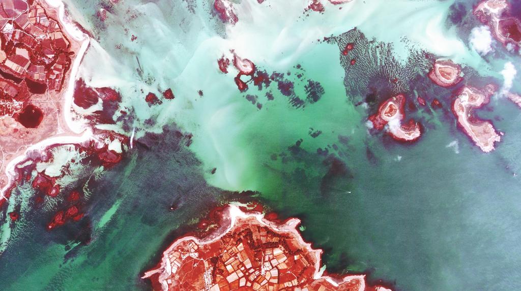
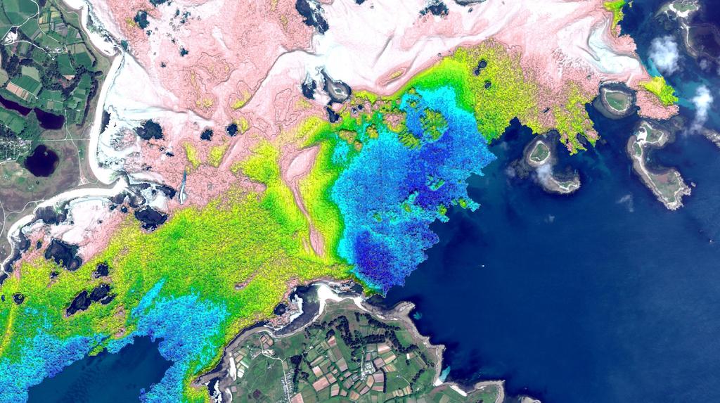
5 resolution optical image image 2 metre grid spacingmulti-spectral bathymetry Example Location: Scilly Isles, UK


6 Applying Satellite Derived Bathymetry Engineering and Environment Ports Construction Dredging Aquaculture Pipelines Modelling Government and Defence Navigation Fisheries Military Transport Urban Planning Energy and Renewables Seismic operations Environmental impact assessments Pipeline routing Monitoring Exploration


 Program; 2m")

7 Application Example Change Detection, Antigua & Barbuda Pre and Post Hurricane Irma, part of disaster relief; UK government tender; Part of the Commonwealth Marine Economies (CME) Program; 2m SDB + Seamless 0.5m land model; Derived from 8-band DigitalGlobe imagery Kilometers

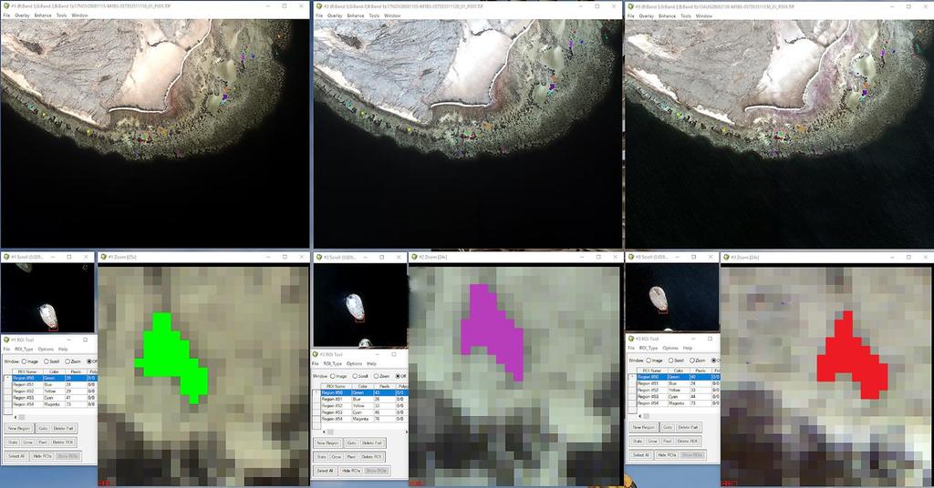
8 Application Example Additional Intelligence, Red Sea Multispectral Image Bathymetry Surface benc


9 Application Example Filling the data gap, UK 1. Freely available data: 2. Freely available data close up the white ribbon: 3. Satellite derived bathymetry data infill: 4. Improved morphological modelling:
; Tide needs to be predicted or modelled in some way meaning uncertainties; Ground truth data is needed to limit uncertainties; difficult in areas where SDB is attractive.")
10 Satellite Derived Bathymetry: Limitations Very dependent on water clarity; 20m depth limit (30m in ideal conditions), and potentially <5m in poor conditions (possibly both exist on same satellite image!); Tide needs to be predicted or modelled in some way meaning uncertainties; Ground truth data is needed to limit uncertainties; difficult in areas where SDB is attractive. 8-band, stretched image

11 IHO: S-44 Standard to 1m Good to 6m
; Tidal predictions are based on UKHO s Total")

12 Satellite Derived Bathymetry: Tide Adjust ground truth to reflect the height of tide when satellite image was taken; Tide is needed to reduce SDB depths to required vertical datum (LAT); Tidal predictions are based on UKHO s Total Tide stations adjusted to location of image by local co-tidal chart; Tide at the satellite image is checked for consistency from surrounding stations. Even if agreement, the min vertical uncertainty is set at 0.3m to account for prediction.

 During MWC production a quality indicator places outputs into 3 bands; Good; Moderate; and Unusable; Good depths are assigned a MWCU of 10% of MWC;")
13 Satellite Derived Bathymetry: Uncertainty Tidal Uncertainty (TU) PT is based on an average of predictions at multiple local tide stations; TU allows for this average, assigning a value based on the difference between the local tide station predictions; TU is always minimum 0.3 metres Measured Water Column (MWC) from satellite image Predicted Tide (PT) relative to Admiralty Chart Datum at time of satellite image Derived Depth (Z) relative to Admiralty Chart Datum Sea Surface Chart Datum MWC Uncertainty (MWCU) During MWC production a quality indicator places outputs into 3 bands; Good; Moderate; and Unusable; Good depths are assigned a MWCU of 10% of MWC; Moderate depths are assigned a MWCU of 20% of MWC; Unusable depths are discarded. Error in depth Actual Sea Floor Derived Sea Floor


14 Satellite Derived Bathymetry: Uncertainty Ground Truth data comparison: Comparison: Shallow Comparison: (12% +0.75m) Deep Comparison: (12% -0.75m)


15 Future Developments: Stereo Bathymetry Advantages of Technique: Object based extraction, independent of seabed type Accounts for differential in Tidal heights Can utilize any HR sensor Ground Truth data collection replacement potential Validation of Optical method St. Croix - SPB accurate to within 4.66% of LiDAR Survey
16
17 Conclusions 1. Satellite Derived Bathymetry is a useful tool, but not in all situations; 2. Satellite Derived Bathymetry must be used with caution and the pitfalls must be known; 3. Uncertainty can only be measured when you have something to measure it and check against.
18 Questions? Richard Flemmings Operations Director
Monetisation of sustainable business models for Satellite Derived Bathymetry
 Monetisation of sustainable business models for Satellite Derived Bathymetry Who are we? We are a UK & UAE based company specialising in satellite derived seabed & environmental mapping products We aim
1 st Tidal and Water Level Working Group Meeting DHN, Niteroi, Brazil 31/03/09 02/04/09 Vertical Offshore Reference Framework (VORF) Chris Jones
 Chris Jones") 1 st Tidal and Water Level Working Group Meeting DHN, Niteroi, Brazil 31/03/09 02/04/09 Vertical Offshore Reference Framework (VORF) Chris Jones United Kingdom Hydrographic Office Presentation Structure
1 st Tidal and Water Level Working Group Meeting DHN, Niteroi, Brazil 31/03/09 02/04/09 Vertical Offshore Reference Framework (VORF) Chris Jones United Kingdom Hydrographic Office Presentation Structure
THE CHALLENGES OF A LARGE-AREA BATHYMETRIC SURVEY
 THE CHALLENGES OF A LARGE-AREA BATHYMETRIC SURVEY Agenda: - Introduction - Tender - Project Planning - Survey - Processing - Delivery - Conclusion 2 Introduction We know less of the oceans at our feet,
Utilizing Vessel Based Mobile LiDAR & Bathymetry Survey Techniques for Survey of Four Southern California Breakwaters
 Utilizing Vessel Based Mobile LiDAR & Bathymetry Survey Techniques for Survey of Four Southern California Breakwaters Western Dredging Association: Pacific Chapter September 2012 Insert: Pipe Location
Reply of Guyana Annex R2
 Summary of Findings: Analysis of Recent Shoreline Revisions to the This report assesses recent shoreline changes made to the 2005 edition of Dutch nautical chart NL 2218. This new edition is credited jointly
Introduction. VORF - Model Development and Principles. The required VORF model transformation accuracies were as follows:
 Introduction In 2006, the United Kingdom Hydrographic Office (UKHO) began testing of the Vertical Offshore Reference Frame (VORF), which had been developed on their behalf by the Department of Geomatic
EMPA 2017 How can the S-102 Bathymetric Surface Product improve safety in navigation and pilotage?
 EMPA 2017 How can the S-102 Bathymetric Surface Product improve safety in navigation and pilotage? Operated by the Norwegian Mapping Authority, Hydrographic Service FREEDOM TO CHOOSE Content What is the
Paper for consideration by ENC Working Group. Use of AU6 ENC cells as an option for Bathymetric ENCs (benc)
") Paper for consideration by ENC Working Group Use of AU6 ENC cells as an option for Bathymetric ENCs (benc) Submitted by: Alvaro Sanchez (AHS) Executive Summary: Compilation of high density bathymetric
Paper for consideration by ENC Working Group Use of AU6 ENC cells as an option for Bathymetric ENCs (benc) Submitted by: Alvaro Sanchez (AHS) Executive Summary: Compilation of high density bathymetric
S-44 edition 5 The IHO s New Standard For Hydrographic Surveys Chris Howlett Head of Seabed Data Centre United Kingdom Hydrographic Office
 S-44 edition 5 The IHO s New Standard For Hydrographic Surveys Chris Howlett Head of Seabed Data Centre United Kingdom Hydrographic Office Chairman of IHO Working Group that created S-44 edition 5 S-44
Marine Renewables Industry Association. Marine Renewables Industry: Requirements for Oceanographic Measurements, Data Processing and Modelling
 Marine Renewables Industry Association Marine Renewables Industry: Requirements for Oceanographic Measurements, Data Processing and Modelling October 2009 Table of Contents 1. Introduction... 1 2. Measurements
BASELINE SURVEY, VISUAL - SITE SPECIFIC
 BASELINE SURVEY, VISUAL - SITE SPECIFIC Introduction As stated in SEPA s policy and in the Fish Farm Manual (1998), scientific data are required by SEPA in order to assess the existing condition on the
Challenges in determining water surface in airborne LiDAR topobathymetry. Amar Nayegandhi, Dewberry 15 th Annual JALBTCX Workshop, June 11 th 2014
 Challenges in determining water surface in airborne LiDAR topobathymetry Amar Nayegandhi, Dewberry 15 th Annual JALBTCX Workshop, June 11 th 2014 Why topobathy LiDAR? Complements acoustic (multi-beam sonar)
Small Footprint Topo-Bathymetric LiDAR
 May 8, 2013 Small Footprint Topo-Bathymetric LiDAR PNAMP Remote Sensing Forum Russ Faux, Co-CEO, WSI Amar Nayegandhi, Manager of Elevation Technologies, Dewberry Colin Cooper, Senior Analyst, WSI Watershed
GNSS Technology for the Determination of Real-Time Tidal Information
 GNSS Technology for the Determination of Real-Time Tidal Information Benjamin Kidder C-Nav Positioning Solutions European region Outline of Topics Covered Introduction to Tides Past and Present Methods
Advanced PMA Capabilities for MCM
 Advanced PMA Capabilities for MCM Shorten the sensor-to-shooter timeline New sensor technology deployed on off-board underwater systems provides navies with improved imagery and data for the purposes of
14/10/2013' Bathymetric Survey. egm502 seafloor mapping
 egm502 seafloor mapping lecture 10 single-beam echo-sounders Bathymetric Survey Bathymetry is the measurement of water depths - bathymetry is the underwater equivalent of terrestrial topography. A transect
INTERNATIONAL HYDROGRAPHIC ORGANIZATION
 INTERNATIONAL HYDROGRAPHIC ORGANIZATION S-67 MARINERS GUIDE TO ACCURACY OF ELECTRONIC NAVIGATIONAL CHARTS (ENC) Edition 0.5 July 2017 Copyright International Hydrographic Organization 2017 This work is
Data Collection and Processing: Elwha Estuary Survey, February 2013
 Data Collection and Processing: Elwha Estuary Survey, February 2013 Ian Miller, WA Sea Grant Olympic Peninsula Field Office, 1502 E. Lauridsen Blvd #82, Port Angeles, WA 98362 immiller@u.washington.edu
Hydrographic Surveying at The Port of London
 Hydrographic Surveying at The Port of London John Dillon-Leetch Port and Terminal Technology 2009 14 th October, Antwerp Overview Introduction Surveying the Thames Navigational Charting High Resolution
Sailing Blind: The Challenges of a Submarine's Navigator
 Sailing Blind: The Challenges of a Submarine's Navigator John Clark, Physics Teacher and Military Historian, Deltona HS, Deltona 2012 Naval Historical Foundation STEM-H Teacher Fellowship Instructional
DUKC Chart Overlay. Presentation to IHO TWL and DQ Working Groups Wollongong, March 2014
 DUKC Chart Overlay Presentation to IHO TWL and DQ Working Groups Wollongong, March 2014 Outline Who is OMC? DUKC description & methodology. DUKC Chart Overlay concept. Chart Overlay application example.
Training program on Modelling: A Case study Hydro-dynamic Model of Zanzibar channel
 Training program on Modelling: A Case study Hydro-dynamic Model of Zanzibar channel Mayorga-Adame,C.G., Sanga,I.P.L., Majuto, C., Makame, M.A., Garu,M. INTRODUCTION Hydrodynamic Modeling In understanding
Paper for Consideration by HSSC8 Development of an Additional Bathymetry Layer standard based on S-57/S-52
 Paper for Consideration by HSSC8 Development of an Additional Bathymetry Layer standard based on S-57/S-52 Submitted by: CIRM, Germany, USA (NOAA) Executive Summary: Proposal for the standardization of
FishRamp Irish Sea VMS
 2015 FishRamp Irish Sea VMS Laurence Rooney AFBI 24/02/2015 Contents Summary Page 2 Data and Method details Page 4 Overview of competing interests Page 6 GB designated Wind-farms in the Irish Sea Page
LiDAR My favourite tool in the bag 2011 St Kitts & Nevis
 LiDAR My favourite tool in the bag 2011 St Kitts & Nevis Lt Cdr Rupert Forester-Bennett RN (ret d) December 5 th to 11 th 2011 Content Collection of geospatial data reasons Overcoming the White Ribbon
The Importance of Mina site within Mecca urban cover change between 1998 and 2013
 FINAL INTERNSHIP REPORT Internship in Urban Remote Sensing Period: February through May 2015 Company: Starlab Ltd, UK The Importance of site within Mecca urban cover change between 1998 and 2013 Author
Comparative Study of Satellite Images Performance in Mapping Lake Bathymetry: Case Study of Al-Manzala Lake, Egypt
 American Journal of Geographic Information System 2018, 7(3): 82-87 DOI: 10.5923/j.ajgis.20180703.02 Comparative Study of Satellite Images Performance in Mapping Lake Bathymetry: Case Study of Al-Manzala
Creation of bathymetric maps using satellite imagery
 Creation of bathymetric maps using satellite imagery Bradley L. McCarthy, Richard C. Olsen, Angela M. Kim Naval Postgraduate School, 1 University Circle, Monterey, CA ABSTRACT Coastal bathymetry near Camp
13. TIDES Tidal waters
 Water levels vary in tidal and non-tidal waters: sailors should be aware that the depths shown on the charts do not always represent the actual amount of water under the boat. 13.1 Tidal waters In tidal
Where are the Bathymetric Hot-Spots?
 Where are the Bathymetric Hot-Spots? Dave Monahan Center for Coastal and Ocean Mapping University of New Hampshire If I win really BIG at the Casino tonight Every now and then, there are news stories of
INTERNATIONAL HYDROGRAPHIC SURVEY STANDARDS
 INTERNATIONAL HYDROGRAPHIC SURVEY STANDARDS by Gerald B. MILLS 1 I. Background The International Hydrographic Organization (IHO) traces its origin to the establishment of the International Hydrographic
Reprocessed QuikSCAT (V04) Wind Vectors with Ku-2011 Geophysical Model Function
 Wind Vectors with Ku-2011 Geophysical Model Function") Reprocessed QuikSCAT (V04) Wind Vectors with Ku-2011 Geophysical Model Function Lucrezia Ricciardulli and Frank Wentz Introduction In April 2011, we reprocessed the QuikSCAT ocean wind vectors using a
Reprocessed QuikSCAT (V04) Wind Vectors with Ku-2011 Geophysical Model Function Lucrezia Ricciardulli and Frank Wentz Introduction In April 2011, we reprocessed the QuikSCAT ocean wind vectors using a
AHO s experience on HD bathymetric ENCs
 AHO s experience on HD bathymetric ENCs ENCWG3 Wollongong 16 18 April 2018 Alvaro Sanchez DD Charting Quality Assurance, Standards and Specifications Australian Hydrographic Office Background 2016 As part
ICES Guidelines for Multibeam Echosounder Data (Compiled September 2006)
") ICES Guidelines for Multibeam Echosounder Data (Compiled September 2006) If you are considering producing a hydrographic survey please read the following information first. Your survey could be used to
ICES Guidelines for Multibeam Echosounder Data (Compiled September 2006) If you are considering producing a hydrographic survey please read the following information first. Your survey could be used to
Advantages of Using Combined Bathymetry and Side Scan Data in Survey Processing T.M. Hiller, L.N. Brisson
 Advantages of Using Combined Bathymetry and Side Scan Data in Survey Processing T.M. Hiller, L.N. Brisson EdgeTech, West WareHam MA, USA EdgeTech 6205 Combined Bathymetric and Side Scan Sonar EdgeTech
Bathymetry Data Collection for Subaqueous Soil Mapping. Maggie Payne 2 nd National Workshop on Subaqueous Soils Rhode Island August 9-12, 2010
 Bathymetry Data Collection for Subaqueous Soil Mapping Maggie Payne 2 nd National Workshop on Subaqueous Soils Rhode Island August 9-12, 2010 Overview of Method Collect tide data Collect bathymetry data
Monitoring tidal movements in Cook Inlet, Alaska, using the integration of remote sensing data, GIS, and inundation models
 Monitoring tidal movements in Cook Inlet, Alaska, using the integration of remote sensing data, GIS, and inundation models Hua Liu Department of political Science and Geography Old Dominion University
ENVIRONMENT AGENCY GREAT OUSE AND 100 FT DRAIN QUARTERLY BATHYMETRIC SURVEY DECEMBER 2013 SITE SURVEY REPORT NO. H6787
 ENVIRONMENT AGENCY GREAT OUSE AND 100FT DRAIN QUARTERLY BATHYMETRIC SURVEY DECEMBER 2013 NO. H6787 LONGDIN & BROWNING (SURVEYS) LIMITED CHERRY TREE HOUSE CARMARTHEN ROAD SWANSEA SA1 1HE H6787 1 Measured
APPENDIX A Hydrodynamic Model Qualicum Beach Waterfront Master Plan
 Page 1 of 21 CLIENT: Town of Qualicum Beach PROJECT: SIGNATURE DATE CONTRIBUTORS : M. Marti Lopez REVIEWED BY : P. St-Germain, EIT APPROVED BY: J. Readshaw, P.Eng ISSUE/REVISION INDEX Issue Details Code
PORTS AUSTRALIA. PRINCIPLES FOR GATHERING AND PROCESSING HYDROGRAPHIC INFORMATION IN AUSTRALIAN PORTS (Version 1.5 November 2012)
") PORTS AUSTRALIA PRINCIPLES FOR GATHERING AND PROCESSING HYDROGRAPHIC INFORMATION IN AUSTRALIAN PORTS (Version 1.5 November 2012) PREFACE These Principles have been prepared by the Hydrographic Surveyors
PORTS AUSTRALIA PRINCIPLES FOR GATHERING AND PROCESSING HYDROGRAPHIC INFORMATION IN AUSTRALIAN PORTS (Version 1.5 November 2012) PREFACE These Principles have been prepared by the Hydrographic Surveyors
Pathways Interns: Annika O Dea, Ian Conery, Andrea Albright
 1 REMOTE SENSING OF COASTAL MORPHODYNAMICS 237 237 237 217 217 217 2 2 2 8 119 27 252 174.59 255 255 255 163 163 163 131 132 122 239 65 53 11 135 12 112 92 56 62 12 13 12 56 48 13 12 111 Kate Brodie Brittany
AGGREGATE DREDGING AND THE MARINE ENVIRONMENT
 AGGREGATE DREDGING AND THE MARINE ENVIRONMENT The marine Aggregate Levy Sustainability Fund ( marine ALSF ) programme represents one of the most substantial investments in UK marine research. The research
HYDROGRAPHIC AND SITE SURVEY REPORT
 HYDROGRAPHIC AND SITE SURVEY REPORT Proposed Pen Site at Dounie, Sound of Jura Prepared for: Kames Fish Farming Ltd Kilmelford Argyll PA34 4XA Tel: +44 (0)1631 720699 TransTech Limited www.transtechltd.com
Boost Your Skills with On-Site Courses Tailored to Your Needs
 Boost Your Skills with On-Site Courses Tailored to Your Needs www.aticourses.com The Applied Technology Institute specializes in training programs for technical professionals. Our courses keep you current
Satellite-Derived Bathymetry Modelling in Shallow Water: A Case Study of Lighthouse Creek, Lagos
 Satellite-Derived Bathymetry Modelling in Shallow Water: A Case Study of Lighthouse Creek, Lagos This is a Peer Reviewed Paper Dupe N. OLAYINKA and Chukwuma J. OKOLIE, Nigeria Keywords: Bathymetry, Satellite-Derived
Interferometric Swath Bathymetry for Large Scale Shallow Water Hydrographic Surveys
 Interferometric Swath Bathymetry for Large Scale Shallow Water Hydrographic Surveys Lisa N. Brisson 1, Damon A. Wolfe 1, Matthew Staley P.S.M. 2 1 EdgeTech 4 Little Brook Rd West Wareham, MA 02576 2 USACE
Welcome! Did You Know...? Aquatic Centre Dock Rebuild. Key Objectives
 1 Welcome! Aquatic Centre Dock Rebuild The City of Vancouver is improving the dock at the Vancouver Aquatic Centre, which is nearing the end of its service life and is in need of replacement. This creates
Airborne Remote Sensing of Surface and Internal Wave Processes on the Inner Shelf
 Airborne Remote Sensing of Surface and Internal Wave Processes on the Inner Shelf Ken Melville, Luc Lenain Scripps Institution of Oceanography North Wind/Wave NDBC Station 42040 29.212 N 88.207 W 19 Oct
CERTIFICATES OF COMPETENCY IN THE MERCHANT NAVY DECK OFFICER STCW 95 OFFICER IN CHARGE OF NAVIGATIONAL WATCH REG. II/1 (UNLIMITED)
") CERTIFICATES OF COMPETENCY IN THE MERCHANT NAVY DECK OFFICER EXAMINATIONS ADMINISTERED BY THE SCOTTISH QUALIFICATIONS AUTHORITY ON BEHALF OF THE MARITIME AND COASTGUARD AGENCY STCW 95 OFFICER IN CHARGE
CERTIFICATES OF COMPETENCY IN THE MERCHANT NAVY DECK OFFICER EXAMINATIONS ADMINISTERED BY THE SCOTTISH QUALIFICATIONS AUTHORITY ON BEHALF OF THE MARITIME AND COASTGUARD AGENCY STCW 95 OFFICER IN CHARGE
Real Time Surveying GPS and HYDRO Software for Tide and Swell Compensation
 Real Time Surveying GPS and HYDRO Software for Tide and Swell Compensation by Mr Michael Walker, B.Surv. (Otago) HYDRO Division Trimble Navigation New Zealand Ltd. Abstract This paper focuses on the use
Evaluation of the Klein HydroChart 3500 Interferometric Bathymetry Sonar for NOAA Sea Floor Mapping
 Evaluation of the Klein HydroChart 3500 Interferometric Bathymetry Sonar for NOAA Sea Floor Mapping Yuhui Ai, Straud Armstrong and Dean Fleury L-3 Communications Klein Associates, Inc. 11 Klein Dr. Salem,
Coastal Engineering Technical Note
 Coastal Engineering Technical Note CETN VI-31 The SHOALS System - A Comprehensive Surveying Tool by Larry E. Parson and W. Jeff Lillycrop PURPOSE The U.S. Army Corps ofengineers (USACE) conducts extensive
Admiralty e-navigator
 Admiralty e-navigator Admiralty e-navigator Service e-navigation is the harmonised collection, integration, exchange, presentation and analysis of maritime information onboard and ashore by electronic
Geospatial Positioning Accuracy Standards Part 5: Standards for Nautical Charting Hydrographic Surveys - Public Review Draft
 Appendix B FGDC Hydrographic Accuracy Standard Geospatial Positioning Accuracy Standards Part 5: Standards for Nautical Charting Hydrographic Surveys - Public Review Draft Subcommittee on Marine and Coastal
The rate versus time can then be the subject of whatever calculation the user chooses, for example:
 Using Neptune Planner Plus to Export Tidal Rates to Excel These notes are intended to assist the interested user in exporting predicted tidal stream rates into a spreadsheet for the estimation of tidal
The impact of ocean bottom morphology on the modelling of long gravity waves from tides and tsunami to climate
 The impact of ocean bottom morphology on the modelling of long gravity waves from tides and tsunami to climate Christian Le Provost and Florent Lyard Laboratoire d Etudes en Géophysique et Océanographie
David Wolcott Lijuan Huang Stephen Gill. Center for Operational Oceanographic Products and Services National Ocean Service/ NOAA Silver Spring, MD
 Establishing Tide Control in an Area with Insufficient Observational Water Level Data: A Case Study of the Kuskokwim River, AK David Wolcott Lijuan Huang Stephen Gill Center for Operational Oceanographic
OCN 201 Tides. Tsunamis, Tides and other long waves
 OCN 201 Tides Tsunamis, Tides and other long waves Storm surges Caused by winds and low atmospheric pressure associated with large storms Can raise sea surface by up to 25 ft, bottom contours magnify effect
Offshore Wind Energy Stringent quality assurance and quality control. Coastal and Freshwater Fast responding and flexible organisation
 Services Oceanographic and Positioning Equipment Rental Meteorological and Oceanographic Surveys Data Analysis and Characterisation Marine Energy Resource Assessment Real-Time Monitoring Founded in 2010,
GPS-based Vertical Control, Unaided by a Shore Station
 GPS-based Vertical Control, Unaided by a Shore Station John Shannon Byrne, SAIC, Newport, R.I. Gail Smith, NAVOCEANO, Stennis Space Center, Miss. Walter Simmons, SAIC, Newport, R.I. Bill Mehaffey, NAVOCEANO,
Appendix 3. Hydrodynamic and sedimentation studies
 Appendix 3 Report EX 4945 Rev 3.0 November 2004 Document Information Project Report title Client Borough of Poole Client Representative Mr Stuart Terry Project No. DDR3553 Report No. EX 4945 Doc. ref.
An Atlas of Oceanic Internal Solitary Waves (February 2004) by Global Ocean Associates Prepared for Office of Naval Research Code 322 PO
 by Global Ocean Associates Prepared for Office of Naval Research Code 322 PO") Overview The is located in the North Atlantic Ocean between southern Ireland and southwest England (Figure 1). The Sea s western edge covers a continental shelf region characterized by rough and irregular
Overview The is located in the North Atlantic Ocean between southern Ireland and southwest England (Figure 1). The Sea s western edge covers a continental shelf region characterized by rough and irregular
T H E A R E A I N VO LV E D
 SEABED DREDGING: THE AREA INVOLVED In the past thirty years the UK marine aggregate industry has become a major supplier of sand and gravel for the UK and European construction industries and domestic
Bathymetry User Needs and Challenges in Australia and New Zealand
 Bathymetry User Needs and Challenges in Australia and New Zealand Nathan Quadros nquadros@crcsi.com.au Shallow Water Survey February 212 Background Recent significant investment in Bathymetric LiDAR acquisition
Analysis of Wave Predictions from the Coastal Model Test Bed using cbathy
 Analysis of Wave Predictions from the Coastal Model Test Bed using cbathy Spicer Bak, Ty Hesser, Jane Smith U.S. Army Engineer Research & Development Center Duck, NC Coastal Model Test Bed Purpose: Automated
HYDROGRAPHIC SECTION QATAR NATIONAL REPORT TO THE 4 TH ROPME SEA AREA HYDROGRAPHIC COMMISSION MEETING
 HYDROGRAPHIC SECTION QATAR NATIONAL REPORT TO THE 4 TH ROPME SEA AREA HYDROGRAPHIC COMMISSION MEETING MUSCAT, OMAN 21 23 MARCH 2011 1. Hydrographic Office / Service This report summarizes the activities
SeaSmart. Jonathan Evans
 SeaSmart A new approach for rapid, on-site resource assessment at potential tidal stream energy array sites using MAS Marine Solutions for the Deep Data World Jonathan Evans Presentation Outline Marine
Crowdsourced Bathymetry Data via Electronic Charting Systems
 Crowdsourced Bathymetry Data via Electronic Charting Systems Evan Robertson evan.robertson@noaa.gov Cooperative Institute for Research in Environmental Sciences (CIRES), University of Colorado, Boulder,
Tracking Marsh Elevation and Water Levels in Elkhorn Slough January 2017
 Tracking Marsh Elevation and Water Levels in Elkhorn Slough January 2017 1931 Charlie Endris GIS Specialist Elkhorn Slough NERR Elkhorn Slough Foundation Central Coast Wetlands Group 2015 Questions Are
Oceanographic Research With The LiquID Station
 Oceanographic Research With The LiquID Station Application Note OCEANOGRAPHIC RESEARCH The field of oceanography relies on knowing the precise physical, chemical, and biological state of seawater at different
EFFECTS OF WAVE, TIDAL CURRENT AND OCEAN CURRENT COEXISTENCE ON THE WAVE AND CURRENT PREDICTIONS IN THE TSUGARU STRAIT
 EFFECTS OF WAVE, TIDAL CURRENT AND OCEAN CURRENT COEXISTENCE ON THE WAVE AND CURRENT PREDICTIONS IN THE TSUGARU STRAIT Ayumi Saruwatari 1, Yoshihiro Yoneko 2 and Yu Tajima 3 The Tsugaru Strait between
Activities of KHOA on creation of S-10X test data sets and S-100 sea trial
 Activities of KHOA on creation of S-10X test data sets and S-100 sea trial Submitted by: Executive Summary: Related Documents: Related Projects: Republic Of Korea (KHOA) KHOA has been conducting a research
3 Maps and Charts In order to navigate we need to use some form of map. The two choices are nautical charts, or land maps.
 13 3 Maps and Charts In order to navigate we need to use some form of map. The two choices are nautical charts, or land maps. Charts Nautical Charts only show the land detail that is visible from the sea.
Project Context. Legend. Jacky. Project Boundary. Fixed Platform/Structure Existing Demonstrator Turbine. Scottish Territorial Waters Boundary
 3 0'0"W Legend C A Jacky B Project Boundary Fixed Platform/Structure Existing Demonstrator Turbine Scottish Territorial Waters Boundary 58 0'0"N British Crown and SeaZone Solutions Limited. All rights
STUDY REPORT W&AR-03 RESERVOIR TEMPERATURE MODEL ATTACHMENT B DON PEDRO RESERVOIR BATHYMETRIC STUDY REPORT
 STUDY REPORT W&AR-03 RESERVOIR TEMPERATURE MODEL ATTACHMENT B DON PEDRO RESERVOIR BATHYMETRIC STUDY REPORT DON PEDRO RESERVOIR BATHYMETRIC STUDY REPORT Prepared for: TURLOCK IRRIGATION DISTRICT MODESTO
Sconser Quarry, Caol Mor
 Sconser Quarry, Caol Mor AUTODEPOMOD MODELLIN G REPORT 4.2017 Registered in Scotland No. 138843 Registered Office, 1st Floor, Admiralty Park, Admiralty Road, Rosyth, FIFE, KY11 2YW Marine Harvest ( Scotland)
April 7, Prepared for: The Caribbean Disaster Emergency Response Agency Prepared by: CEAC Solutions Co. Ltd.
 April 7, 2006 Prepared for: The Caribbean Disaster Emergency Response Agency Prepared by: Introduction CEAC Solutions Co. Ltd was commissioned in May 2005 to prepare coastal beach erosion hazard maps for
Click to edit Master title style Advanced Military Layers. and the Historic Environment
 Advanced Military Layers and the Historic Environment Paul Baggaley and Louise Tizzard Wessex Archaeology 1 Click to edit Objectives Master title style to establish the degree of mutual benefit in integrating
RESOLUTION A.817(19) adopted on 23 November 1995 PERFORMANCE STANDARDS FOR ELECTRONIC CHART DISPLAY AND INFORMATION SYSTEMS (ECDIS)
 adopted on 23 November 1995 PERFORMANCE STANDARDS FOR ELECTRONIC CHART DISPLAY AND INFORMATION SYSTEMS (ECDIS)") A 19/Res.817 15 December 1996 Original: ENGLISH ASSEMBLY 19th session Agenda item 10 RESOLUTION A.817(19) adopted on 23 November 1995 PERFORMANCE STANDARDS FOR ELECTRONIC CHART DISPLAY AND INFORMATION
A 19/Res.817 15 December 1996 Original: ENGLISH ASSEMBLY 19th session Agenda item 10 RESOLUTION A.817(19) adopted on 23 November 1995 PERFORMANCE STANDARDS FOR ELECTRONIC CHART DISPLAY AND INFORMATION
MAY0 COUNTY COUNCIL W.ESTPORT MARINE SURVEY
 MAY0 COUNTY COUNCIL W.ESTPORT MARINE SURVEY VOLUME 1 HYDRODYNAMIC & WATER QUALITY MODELLINQ Tolaphano 0232 667914 Fwlmlk a=z 668288 Morton PREFACE,*.--. -- - -I Kirk McClure Morton, in conjunction with
A real time vessel air gap monitoring system
 Journal of Physics: Conference Series A real time vessel air gap monitoring system To cite this article: D McStay and K Thabeth 2009 J. Phys.: Conf. Ser. 178 012038 View the article online for updates
Copicut Reservoir Sidescan Sonar. Fall River, MA May 7, 2013
 Copicut Reservoir Sidescan Sonar Fall River, MA May 7, 2013 1 Table of Contents Section 1: Mission Overview... 3 Background... 3 Vehicle General Information... 3 Vehicle Mission Details... 4 Area of Operation...
The Case for Depth Imaging All 3D Data: Complex Thrust Belts to Low Relief Resource Plays
 The Case for Depth Imaging All 3D Data: Complex Thrust Belts to Low Relief Resource Plays John Young, Greg Johnson, Stephen Klug, John Mathewson; WesternGeco; Denver, CO Introduction Prestack time migration
Hydrodynamic and hydrological modelling to support the operation and design of sea ports
 Hydrodynamic and hydrological modelling to support the operation and design of sea ports Data needs and examples Martijn de Jong (port/nautical requirements, waves, currents) Sofia Caires (mean and extreme
Breakwaters and closure dams CT 5308 Exercise 2011: Pointe Noire, Congo
 Breakwaters and closure dams CT 5308 Exercise 2011: Pointe Noire, Congo The town of Pointe Noire is the main port city in the Republic of the Congo and sits on the south-western African coast some 150
SCIENCE OF TSUNAMI HAZARDS
 SCIENCE OF TSUNAMI HAZARDS ISSN 8755-6839 Journal of Tsunami Society International Volume 31 Number 2 2012 SEA LEVEL SIGNALS CORRECTION FOR THE 2011 TOHOKU TSUNAMI A. Annunziato 1 1 Joint Research Centre,
Comparison of data and model predictions of current, wave and radar cross-section modulation by seabed sand waves
 Comparison of data and model predictions of current, wave and radar cross-section modulation by seabed sand waves Cees de Valk, ARGOSS Summary SAR Imaging of seabed features Seabed Sand waves Objectives
Location of Proposed Dredging Areas, spoil disposal area, beaches identified for nourishment and the Study Area Figure 1
 42 41 4 9 Little Channel Bournemouth Beach Bournemouth Beach (Sand and gravel) Middle RORO Turning Basin Ship Channel Poole Beach Swash Channel 8 Swanage Beach Admiralty Chart 2615 Study Area Proposed
Marine Mammal Mitigation Systems
 Marine Mammal Mitigation Systems Seiche Measurements Limited (Seiche) designs and manufactures underwater sound measurement and marine mammal monitoring equipment for the oil and gas and renewables sectors.
InVEST model demo: Renewable Energy (Wave Energy) Gregg Verutes
 Gregg Verutes") InVEST model demo: Renewable Energy (Wave Energy) Gregg Verutes Some WEC Devices Attenuator Point Absorber Oscillating Water Column Overtopping Device Oscillating Wave Surge Converter Submerged Pressure
InVEST model demo: Renewable Energy (Wave Energy) Gregg Verutes Some WEC Devices Attenuator Point Absorber Oscillating Water Column Overtopping Device Oscillating Wave Surge Converter Submerged Pressure
LAKEBED CHARACTERIZATION USING SIDE-SCAN DATA FOR INVESTIGATING THE LATEST LAKE SUPERIOR COASTAL ENVIRONMENT CONDITIONS
 Michigan Technological University Digital Commons @ Michigan Tech Dissertations, Master's Theses and Master's Reports 2017 LAKEBED CHARACTERIZATION USING SIDE-SCAN DATA FOR INVESTIGATING THE LATEST LAKE
Tsunamis are not observed via height rather by orbital velocity from shallow-water wave physics
 Modeling of Tsunami Current Flows Presenter: Dr. Don Barrick President, CODAR Ocean Sensors Coauthors: Dr. Belinda Lipa, Chad Whelan RIAM Workshop on Oceanographic Radar Tsunami capability of HF radar
NAVAL POSTGRADUATE SCHOOL THESIS
 NAVAL POSTGRADUATE SCHOOL MONTEREY, CALIFORNIA THESIS AUTOMATING NEARSHORE BATHYMETRY EXTRACTION FROM WAVE MOTION IN SATELLITE OPTICAL IMAGERY by Steven Mancini March 2012 Thesis Advisor: Second Reader:
S-102 v2.0 Status Brief
 S-102 v2.0 Status Brief S-100 TSM6 (SEP 2018) David W Brazier, US Navy Stacy Johnson, US Navy The views expressed in this article are those of the author and do not necessarily reflect the official policy
FULL SCALE MEASUREMENT OF DYNAMIC SHIP MOTIONS AND SQUAT
 FULL SCALE MEASUREMENT OF DYNAMIC SHIP MOTIONS AND SQUAT Mr. Gary Rolph Chief Hydrographic Surveyor Port of Brisbane Corporation Mr. Peter Rumball Surveyor Port of Brisbane Corporation Dr. Terry O'Brien
Robin J. Beaman. School of Earth and Environmental Sciences, James Cook University, Cairns, Qld 4870, Australia.
 Robin J. Beaman School of Earth and Environmental Sciences, James Cook University, Cairns, Qld 4870, Australia. Email: robin.beaman@jcu.edu.au Seminar to SSSI Qld Hydrography Coping with Nature, Brisbane,
Admiralty Leisure Folio SC5601 East Devon and Dorset Coast, Exmouth to Christchurch
 Admiralty Leisure Folio SC5601 East Devon and Dorset Coast, Exmouth to Christchurch The Notices to Mariners (NMs) listed below apply to the latest edition of SC5601 (11 th Edition) published on 24 th March
DISCUSSION PAPER: NEW GENERALISATION POLICY FOR SMALL SCALE ADMIRALTY CHARTS.
 DISCUSSION PAPER: NEW GENERALISATION POLICY FOR SMALL SCALE ADMIRALTY CHARTS. PREFACE. Throughout this paper we will be making reference to largest scale, second scale, third scale coverage on an SNC (Standard
Comparison of flow models
 Comparison of flow models Rémi Gandoin (remga@dongenergy.dk) March 21st, 2011 Agenda 1. Presentation of DONG Energy 2. Today's presentation 1. Introduction 2. Purpose 3. Methods 4. Results 3. Discussion
Wind Project Siting & Resource Assessment
 Wind Project Siting & Resource Assessment David DeLuca, Project Manager AWS Truewind, LLC 463 New Karner Road Albany, NY 12205 ddeluca@awstruewind.com www.awstruewind.com AWS Truewind - Overview Industry