T H E A R E A I N VO LV E D
|
|
|
- Helena Lawrence
- 6 years ago
- Views:
Transcription
1

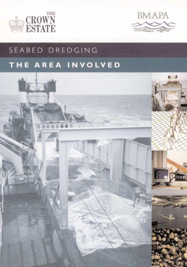
2 SEABED DREDGING: THE AREA INVOLVED In the past thirty years the UK marine aggregate industry has become a major supplier of sand and gravel for the UK and European construction industries and domestic coastal protection schemes. Its impact on the seabed is carefully considered and control of the industry s activities is effectively managed and closely monitored. Marine aggregate resources are geographically well defined Sand and gravel deposits on the seabed that comply with BS 882 quality standards are not widespread. Economic factors, technical constraints and the occurrence of suitable deposits of sand and gravel dictate the location of dredging areas. Distance from the licence area to the point of landing and market is critical in determining the commercial viability and competitiveness of marine aggregates.water depth is also fundamental, dredgers can work in a maximum water depth of 50 metres but most extraction takes place between I 0 and 35 metres.these factors have led to a concentration of dredging licences in areas such as the Outer Thames Estuary, off Great Yarmouth and around the Isle of Wight, and their absence in others, for example Lyme Bay and the western approaches.

3 The area licensed is a tiny percentage of the seabed The total area of seabed where licences permit dredging and where extraction may take place is equal to 0.8% of the UK Continental Shelf.The actual area dredged each year is only 0.1 2%. Even when considered on a regional basis the areas are small particularly when compared with trawling for fish.the International Council for the Exploration of the Sea (ICES), a fisheries research and protection organisation, state in their I 992 report that only 0.03% of the North Sea is dredged for aggregates each year compared with the trawling of fish, which affects the seabed in a similar way to dredging and covers 54% of the North Sea. The area dredged is less than l5% of the area licensed The area of seabed dredged and the tonnage extracted compared with the area licensed and the maximum level of permitted extraction vary widely from licence to licence and region to region These differences mainly reflect: The distribution of sand and grovel These can be in well defined areas or in irregular shaped patches with intervening areas of nonproductive seabed.this limits the area of a licence that will be actually dredged. Material quality Some reserves are only acceptable for one-off contracts with some licensed areas only being used occasionally. Market demand This varies significantly from year to year and can be strongly influenced by major infrastructure projects such as road, rail and development schemes, and beach nourishment requirements. Area of seabed licensed in 1997 Region Approximate* Total Area % of Total Area % of Area of Licensed for Seabed Dredged Licensed Seabed Seabed/km2 Dredging/km2 Licensed Annually km 2 Dredged Annually Humber 90, East 10, Thames I0, South 40, South West 30, North West Total 200, * east of Scilly Isles.


4 We are doing more to reduce the area licensed and the area dredged Even when a positive Government View has been issued and a licence granted, the licensees organise their dredging to reduce as far as possible the impact on other sea users, particularly fishermen. Dredging is closely monitored Since I 993 every vessel dredging on a Crown [state licence has been fitted with an Electronic Monitoring System(EMS) which automatically records the date, time and position of all dredging activity on a computer disk. These records are analysed to give precise details of the area of seabed dredged. Zoning Restricting dredging to only part of a licence area this effectively reduces the area of seabed available for dredging at any one time by 33%. Seasonal restrictions These arrangements prohibit dredging from part or whole of a licence area during a period of the year to allow access for fishermen. Shoring resources By extracting resources through joint or shared licences more than one company s requirements can be met from a single area.this effectively shortens the licence period and reduces the area of seabed worked at any one time. Accurate dredging Modern dredging vessels are very sophisticated and can dredge with a high degree of precision using satellite navigation systems. Analysis of Electronic Monitoring System (EMS) records shows that more than 90 % of material is extracted from only I 0% of the area licensed.


5 SEABED DREDGING: THE AREA INVOLVED We will continue to ensure that the impact is restricted by striving for maximum efficiency in the area dredged Regular Resource Surveys The use of modern survey methods means that the resources available can be identified and targeted more accurately increasing the efficiency of use of licensed areas. Licence Monitoring The effects of dredging will continue to be monitored to a very high standard and will be used to develop management plans. Research Research into the effects of aggregate extraction on the marine environment will continue to be funded by the Crown Estate and the dredging industry and the results made available to all concerned.
6 Background Dredging offshore for aggregates began in the early Twentieth Century but it did not reach a significant scale until the 1 970s as markets for marine aggregates expanded and dredging technology improved. Al most all marine aggregate extraction takes place from licences on seabed owned by the Crown Estate. Planning permission is granted by the Department of the Environment,Transport and the Regions or the Welsh/Scottish Office under the Government View Procedure.The Crown [state will only grant a licence following a favourable Government View. The Crown Estate The Crown Estate is a landed estate including more than I 20,000 hectares of agricultural land in England, Scotland and Wales, substantial blocks of commercial property (primarily in London) and an extensive marine estate covering 55% of the foreshore and all of the seabed out to the I 2 mile Territorial Limit. Its origins date back to the reign of King Edward the Confessor The Crown Estate is part of the hereditary possessions of the Sovereign in right of the Crown managed under the provisions of the Crown Estate Act I 96 I by the Crown Estate Commissioners who have a duty to maintain and enhance the value of the Estate and the income derived from it.the net revenue surplus is paid to the Exchequer BMAPA The British Marine Aggregate Producers Association (BMAPA) was formed in I 992 and comprises members of the Quarry Products Association with a marine interest.the UK operates around 35 vessels on 78 production licences around the UK.The vessels are almost entirely British registered and carry British crew. BMAPA represents the industry and its members are: ARC Marine Ltd, Britannia Aggregates Ltd, British Dredging Aggregates Ltd, Kendall Bros. (Portsmouth) Ltd, Northwood (Fareham)Ltd, Norwest Sand and Ballast Company Ltd, South Coast Shipping Company Ltd, United Marine Dredging Ltd, East Coast Aggregates Ltd.
AGGREGATE DREDGING AND THE MARINE ENVIRONMENT
 AGGREGATE DREDGING AND THE MARINE ENVIRONMENT The marine Aggregate Levy Sustainability Fund ( marine ALSF ) programme represents one of the most substantial investments in UK marine research. The research
APPENDIX 2 PROPOSAL FOR REPLACEMENT FOR POOLE (DOLPHIN) LEISURE CENTRE FINAL SPECIFICATION
 LEISURE CENTRE FINAL SPECIFICATION") APPENDIX 2 PROPOSAL FOR REPLACEMENT FOR POOLE (DOLPHIN) LEISURE CENTRE FINAL SPECIFICATION 1 PURPOSE 1.1 To provide the following information and supporting evidence for the Member decision (reference
APPENDIX 2 PROPOSAL FOR REPLACEMENT FOR POOLE (DOLPHIN) LEISURE CENTRE FINAL SPECIFICATION 1 PURPOSE 1.1 To provide the following information and supporting evidence for the Member decision (reference
Location of Proposed Dredging Areas, spoil disposal area, beaches identified for nourishment and the Study Area Figure 1
 42 41 4 9 Little Channel Bournemouth Beach Bournemouth Beach (Sand and gravel) Middle RORO Turning Basin Ship Channel Poole Beach Swash Channel 8 Swanage Beach Admiralty Chart 2615 Study Area Proposed
MARINE ANTIQUITIES SCHEME
 For more information on the Marine Antiquities Scheme visit www.marinefinds.org.uk The MAS support team Wessex Archaeology Portway House Old Sarum Park Salisbury SP4 6EB T: 01722 326867 E: mas@wessexarch.co.uk
GCSE 4241/02 GEOGRAPHY SPECIFICATION B HIGHER TIER UNIT 1
 Surname Other Names Centre Number 0 Candidate Number GCSE 4241/02 GEOGRAPHY SPECIFICATION B HIGHER TIER UNIT 1 P.M. TUESDAY, 4 June 2013 1 hour For examiner s use Question 1 Question 2 Total Marks 30 30
2016 No. 716 SEA FISHERIES, ENGLAND SHELLFISH, ENGLAND. The Fal Fishery Order 2016
 S T A T U T O R Y I N S T R U M E N T S 2016 No. 716 SEA FISHERIES, ENGLAND SHELLFISH, ENGLAND The Fal Fishery Order 2016 Made - - - - 6th July 2016 Laid before Parliament 8th July 2016 Coming into force
Tuesday 6 June 2017 Afternoon
 Oxford Cambridge and RSA F Tuesday 6 June 2017 Afternoon GCSE GEOGRAPHY A A732/01 Geographical Skills (Foundation Tier) *5820270462* Candidates answer on the Question Paper. OCR supplied materials: An
Best Practice Guidance for Assessing the Financial Performance of Fishing Gear: Industry-led gear trials
 Best Practice Guidance for Assessing the Financial Performance of Fishing Gear: Industry-led gear trials Prepared for The UK Fisheries Economic Network (UKFEN) by Seafish Introduction and Background Reducing
14 NOISE AND VIBRATION
 14 NOISE AND VIBRATION 14.1 EXISTING ENVIRONMENT 14.1.1 The noise environment within Poole Harbour is generally characterised by low to medium noise levels depending on location. For example, certain areas
The expenditure exceeds the income generated, creating an annual shortfall of around 17,447 per annum.
 Dear Parents, 24th January 2018 It is with a heavy heart that we have to inform you that the swimming pool, based at Mundesley Infant school will close at the end of this term (March 28th 2018). Throughout
Preliminary Survey Notification and Information for Fisheries Interests.
 1) Viking Link Project The Viking Link project is a proposal to build a high voltage direct current (HVDC) electricity interconnector between the Lincolnshire Coast in the UK and Southern Jutland in Denmark
Admiralty Leisure Folio SC5601 East Devon and Dorset Coast, Exmouth to Christchurch
 Admiralty Leisure Folio SC5601 East Devon and Dorset Coast, Exmouth to Christchurch The Notices to Mariners (NMs) listed below apply to the latest edition of SC5601 (11 th Edition) published on 24 th March
Fishing for Litter South West End of 2015 Report
 Fishing for Litter South West 2014-2017 End of 2015 Report This year sees the end of matching funding projects for FFL from the EU through the Cornwall & Isles of Scilly Fisheries Local Action Group and
SHOREHAM BEACH LOCAL NATURE RESERVE
 SHOREHAM BEACH LOCAL NATURE RESERVE Coastal Geography Education Programme 2014-15 S. Savage 2014 COASTAL GEOGRAPHY OPPORTUNITIES Shoreham Beach Shoreham Beach is a shingle spit formed over many centuries
Shaded blocks indicate activity.
 09 AUGUST 2018 ISSUE 16 Shaded blocks indicate activity. What s inside? New Hazards (p.3) Area 1(p.4) 1. Deployment of Buoys Area 2 N.A Area 3 (p.5-8) 1. Notice to Fishermen 2. Survey Activity Area 4 N.A
Protection for Vessels Engaged in Servicing Submarine Cables
 Protection for Vessels Engaged in Servicing Submarine Cables Proposed Amendments to COLREGS Brief to Navigation Safety Advisory Council November 28, 2012 Tampa, FL Dr. Ronald J. Rapp TE SubCom and Representing
Guidance Note: Commercial Fishing and Wildlife. December 2008.
 Guidance Note: Commercial Fishing and Wildlife December 2008. 1 Since the 1990s, marine wildlife has received greater protection from a range of activities including commercial fishing Fishing activities
North-East Atlantic Commission NEA(18)05. Mixed-Stock Fisheries. (Tabled by the European Union)
05. Mixed-Stock Fisheries. (Tabled by the European Union)") North-East Atlantic Commission NEA(18)05 Mixed-Stock Fisheries (Tabled by the European Union) NEA(18)05 Mixed-Stock Fisheries (Tabled by the European Union) 1) Brief description of existing MSFs EU-Finland
North-East Atlantic Commission NEA(18)05 Mixed-Stock Fisheries (Tabled by the European Union) NEA(18)05 Mixed-Stock Fisheries (Tabled by the European Union) 1) Brief description of existing MSFs EU-Finland
Map Showing NAFO Management Units
 Map Showing NAFO Management Units Biology Are 6 species of seals in Atlantic Canadian waters, all of which occur in Newfoundland Two Arctic Species (Ringed, Bearded) Two temperate (Grey, Harbour) Two migratory
HARBOUR SEDIMENTATION - COMPARISON WITH MODEL
 HARBOUR SEDIMENTATION - COMPARISON WITH MODEL ABSTRACT A mobile-bed model study of Pointe Sapin Harbour, in the Gulf of St. Lawrence, resulted in construction of a detached breakwater and sand trap to
Non Technical Summary
 ENVIRONMENTAL STATEMENT Llanelli Sand Dredging Ltd Licence Variation Application for Aggregate Production Licence Area 476 Nobel Banks: Non Technical Summary October 2009 Environmental Resources Management
FishRamp Irish Sea VMS
 2015 FishRamp Irish Sea VMS Laurence Rooney AFBI 24/02/2015 Contents Summary Page 2 Data and Method details Page 4 Overview of competing interests Page 6 GB designated Wind-farms in the Irish Sea Page
SENIOR RANKING SCHEME With effect from 1st September 2013
 SENIOR RANKING SCHEME With effect from 1st September 2013 DEFINITIONS Season Senior Open Competitions Committee FIE Competition Competition Event The 12-month period starting on the 1st day of September
Wave Prediction in the Santa Barbara Channel
 Wave Prediction in the Santa Barbara Channel OCS Study MMS 2001-055 Final Technical Summary Final Study Report U.S. Department of the Interior Minerals Management Service Pacific OCS Region Wave Prediction
Japan's National Plan of Action for Conservation and Management of Sharks. Revised Version
 Japan's National Plan of Action for Conservation and Management of Sharks Revised Version March 2009 Fisheries Agency Government of Japan Japan's National Plan of Action for Conservation and Management
FISHERY BY-PRODUCT REPORT
 FISHERY BY-PRODUCT REPORT IFFO GLOBAL STANDARD FOR RESPONSIBLE SUPPLY OF FISHMEAL AND FISH OIL FISHERY By-Product: LOCATION: King Scallop (Pecten maximus) UK & Ireland-Ices Area IVa-c, VI a, VIIa,b,d-h,j2
SCIENTIFIC COMMITTEE NINTH REGULAR SESSION August 2013 Pohnpei, Federated States of Micronesia
 SCIENTIFIC COMMITTEE NINTH REGULAR SESSION 6-14 August 2013 Pohnpei, Federated States of Micronesia ANNUAL REPORT TO THE COMMISSION PART 1: INFORMATION ON FISHERIES, RESEARCH, AND STATISTICS WCPFC-SC9-AR/CNM-35
Reasons for a Welsh National Side
 PET(4) CRI 02 Petitions Committee Consultation on petition P-04-335 The Establishment of a Welsh Cricket Team Response from Jonathan Edwards MP Towards a National Future for Welsh Cricket Jonathan Edwards
WESTERMOST ROUGH. OffshOre Wind farm.
 WESTERMOST ROUGH OffshOre Wind farm www.westermostrough.co.uk Welcome to Westermost Rough The Westermost Rough Offshore Wind Farm, situated off the Holderness coast, is currently in the latter stages of
Explanatory Memorandum to the Scallop Fishing (Wales) Order 2010.
 Order 2010.") Explanatory Memorandum to the Scallop Fishing (Wales) Order 2010. This Explanatory Memorandum has been prepared by the Fisheries Policy Branch of the Department for Rural Affairs and is laid before the
Explanatory Memorandum to the Scallop Fishing (Wales) Order 2010. This Explanatory Memorandum has been prepared by the Fisheries Policy Branch of the Department for Rural Affairs and is laid before the
Dorset s Fishing Industry
 Fishing has always been an important activity within Dorset s coastal zone. To date (2010), activity focuses on a fleet of approximately 230 vessels based in Dorset s ports and harbours, and a larger number
The economic implications of changing regulations for deep sea fishing: UK case study
 The economic implications of changing regulations for deep sea fishing: UK case study Stephen Mangi, Andrew Kenny, Lisa Readdy, Paulette Posen, Ana Ribeiro-Santos, Francis Neat and Finlay Burns Mangi et
BOURNEMOUTH BEACH MANAGEMENT
 BOURNEMOUTH BEACH MANAGEMENT Information pack for SCOPAC visit, 20 th May 2016 Plan A Good weather 09:45 Delegates board for complimentary tea and coffee 10:00 Depart for Bournemouth scheme, observing
Request Number IR1-12: Flow Passage. Information Request
 Request Number IR1-12: Flow Passage Information Request Provide additional information about the 100 metre flow passage channel scenario between the Westshore Terminals and the proposed Project terminal
Marine Character Areas MCA 23 SOUTH PEMBROKESHIRE OPEN WATERS. Location and boundaries
 Marine Character Areas MCA 23 SOUTH PEMBROKESHIRE OPEN WATERS Location and boundaries This Marine Character Area (MCA) encompasses the waters surrounding the southern coast the Pembrokeshire Peninsula.
5. purse seines 3 000
 Sea Bass Q and A Latest News What have the 28 Member States decided on 2 July? The EU has today taken another step to protect sea bass. The 28 EU member states agreed to the Commission's proposal to increase
Evolution of Deepwater Coral Protection in the Southeast U.S
 Evolution of Deepwater Coral Protection in the Southeast U.S Tina Udouj, Florida Fish and Wildlife Conservation Commission Roger Pugliese, South Atlantic Fishery Management Council Overview Deepwater Corals
ROV Development ROV Function. ROV Crew Navigation IRATECH SUB SYSTEMS 2010
 IR AT EC H SU B SY ST EM S 20 10 Remotely Operated Vehicle ROV INTRODUCTORY 2008 2008 1 KEY POINTS ROV Introductory ROV Development ROV Function Types of ROV ROV Crew Navigation ROV Components 2 ROV Development
Environmentally Responsible Fisheries Project FINAL SUMMARY REPORT
 Environmentally Responsible Fisheries Project FINAL SUMMARY REPORT Prepared for Defra By: Cefas: Jon Elson Chris Firmin Julian Addison Seafish: Hazel Curtis Enrico Longini Mark Edmonds 2010 Cefas contract:
Tuesday 6 June 2017 Afternoon
 Oxford Cambridge and RSA H Tuesday 6 June 2017 Afternoon GCSE GEOGRAPHY A A732/02 Geographical Skills (Higher Tier) *5820567782* Candidates answer on the Question Paper. OCR supplied materials: An Insert
Study on the Transfer System in Europe
 Study on the Transfer System in Europe ECA General Assembly March 3, 2014 emanuele grasso partner at pwc ernesto paolillo professor at liuc university 14,322 The total number of international transfers
Frequently asked questions
 Frequently asked questions Improving recreational boating safety Who will be most affected by these reforms? The primary focus of the reforms is the estimated 676 000 recreational marine licence holders
Uncertainty Estimates in Satellite Derived Bathymetry
 Uncertainty Estimates in Satellite Derived Bathymetry Richard Flemmings, TCarta #chcnsc2018 Introduction and Overview 1. TCarta 2. Satellite Derived Bathymetry Overview 3. Satellite Derived Bathymetry
CONCLUSIONS AND RECOMMENDATIONS
 CHAPTER 5: CONCLUSIONS AND RECOMMENDATIONS 5.1 General This chapter presents the conclusions and main recommendations flowing from the analysis of level crossing systems and safety performance in several
UK Coastal Atlas of Recreational Boating 2.0: User Guide
 UK Coastal Atlas of Recreational Boating 2.0: User Guide Royal Yachting Association September 2016 RYA UK Coastal Atlas of Recreational Boating 2.0 Contents 1. Overview... 2 1.1. What is it?... 2 1.2.
FLEET ECONOMIC PERFORMANCE DATASET
 FLEET ECONOMIC PERFORMANCE DATASET 28-16 Steve Lawrence Arina Motova Jennifer Russell Date: September 217 Seafish Report No: SR79 ISBN No: 978-1-91173-15-4 Copyright Seafish 217 Seafish Economics Seafish
21/02/2018. How Far is it Acceptable to Walk? Introduction. How Far is it Acceptable to Walk?
 21/2/218 Introduction Walking is an important mode of travel. How far people walk is factor in: Accessibility/ Sustainability. Allocating land in Local Plans. Determining planning applications. Previous
DSBG Findings Helping Fishermen and Policy Makers Explore the Economics of Deep Set Buoy Gear in the West Coast Swordfish Fishery
 June 2016 DSBG Findings Helping Fishermen and Policy Makers Explore the Economics of Deep Set Buoy Gear in the West Coast Swordfish Fishery Photos courtesy of The Pew Charitable Trusts Developed by Cap
LANCU60Ga - SQA Unit Code D9HX 04 Contribute to the management of a fishery
 Overview This standard deals with the competence required by individuals who are involved in managing a fishery. It is aimed at those who work in fisheries management on either a full- or part-time basis,
Certified Professionals in Hydrographic Solutions
 Certified Professionals in Hydrographic Solutions Client Satisfaction is our Deliverable Port of Brisbane Pty Ltd Port Surveys Certified Professionals in Hydrographic Surveying Tel +61 (0) 7 3258 4820
While oil and gas is the nations largest export product in value, fish is the second largest. Both activities are crucial for the Norwegian economy.
 Oil and fish in Norwegian waters conflict or coexistence? Kristoffersen Arne, Norwegian Coastal Fishermen Union representative, Norway 1. Presentation: Arne Helge Kristoffersen: Representative from the
RESOLUTION 15/04 CONCERNING THE IOTC RECORD OF VESSELS AUTHORISED TO OPERATE IN THE IOTC AREA OF
 RESOLUTION 15/04 CONCERNING THE IOTC RECORD OF VESSELS AUTHORISED TO OPERATE IN THE IOTC AREA OF COMPETENCE Keywords: Authorised vessels; active vessels; auxiliary, supply and support vessels; IMO number;
2017 NORTHERN COD STEWARDSHIP FISHERY MANAGEMENT PLAN PROPOSAL SUBMITTED TO
 2017 NORTHERN COD STEWARDSHIP FISHERY MANAGEMENT PLAN PROPOSAL SUBMITTED TO FISHERIES & OCEANS CANADA April - 2017 BACKGROUND The Newfoundland and Labrador Groundfish Industry Development Council was formed
Strategic Plan Saving Lives and Building Great Communities
 Surf Lifesaving Western Australia Strategic Plan 2015-2020 Saving Lives and Building Great Communities Contents 1 Introduction 2 1.1 Our Purpose 3 1.2 Our Values 3 1.3 The Forces shaping Surf Life Saving
CONDITIONS OF USE OF THIS REPORT COPYRIGHT NAMIBIAN MARINE PHOSPHATE (PTY) LTD 2014 ALL RIGHTS RESERVED
 LTD 2014 ALL RIGHTS RESERVED") CONDITIONS OF USE OF THIS REPORT COPYRIGHT NAMIBIAN MARINE PHOSPHATE (PTY) LTD 2014 ALL RIGHTS RESERVED. All rights to the intellectual property and/or contents of this document remain vested in Namibian
CONDITIONS OF USE OF THIS REPORT COPYRIGHT NAMIBIAN MARINE PHOSPHATE (PTY) LTD 2014 ALL RIGHTS RESERVED. All rights to the intellectual property and/or contents of this document remain vested in Namibian
MACKEREL LICENSING (MANX AND CHANNEL ISLANDS BOATS) ORDER 1978
 ORDER 1978") MACKEREL LICENSING (MANX AND CHANNEL ISLANDS BOATS) ORDER 1978 JERSEY REVISED EDITION OF THE LAWS 14.300 APPENDIX 3 Jersey R & O 6631 Sea Fish (Conservation) Act 1967. MACKEREL LICENSING (MANX AND CHANNEL
MACKEREL LICENSING (MANX AND CHANNEL ISLANDS BOATS) ORDER 1978 JERSEY REVISED EDITION OF THE LAWS 14.300 APPENDIX 3 Jersey R & O 6631 Sea Fish (Conservation) Act 1967. MACKEREL LICENSING (MANX AND CHANNEL
Measurement of underwater noise arising from marine aggregate operations
 Loughborough University Institutional Repository Measurement of underwater noise arising from marine aggregate operations This item was submitted to Loughborough University's Institutional Repository by
Joint communiqué from the Ghana National Canoe Fishermen Council (GNCFC) and National Fish Processors and Traders Association (NAFPTA)
 and National Fish Processors and Traders Association (NAFPTA)") Joint communiqué from the Ghana National Canoe Fishermen Council (GNCFC) and National Fish Processors and Traders Association (NAFPTA) Priorities for small-scale fishers, processors and traders in the
Joint communiqué from the Ghana National Canoe Fishermen Council (GNCFC) and National Fish Processors and Traders Association (NAFPTA) Priorities for small-scale fishers, processors and traders in the
Monitoring beach usage on Gold Coast beaches: Is it beneficial?
 Monitoring beach usage on Gold Coast beaches: Is it beneficial? Peta Williams 1, Gervase Tuxworth 2 and Chris Lane 2 1 Griffith Centre for Coastal Management (GCCM) Gold Coast Campus, Griffith University
Challenges, Prospects & Opportunities. Seychelles Fisheries Sector
 Challenges, Prospects & Opportunities Seychelles Fisheries Sector Geographical Location General information Total population: 94,000 people Total territory: 1,374,000 km 2 Land/Ocean territory:459 km 2
SANDBANKS COAST PROTECTION
 SANDBANKS COAST PROTECTION David Robson, Senior Engineer, Coastal & Drainage Team Borough of Poole Leisure Services (T) 01202 265265 (E) d.robson@poole.gov.uk May 2003 SANDBANKS COAST PROTECTION Introduction
pfli ) f 'fhi H.r'\j,ijn''^
 f 'fhi H.r'\j,ijn''^") pfli ) f 'fhi H.r'\j,ijn''^ PROCEEDINGS OF THE SYMPOSIUM ON LIVING RESOURCES OF THE SEAS AROUND INDIA ICAR SPECIAL PUBLICATION C NTR/^L MARINE FISHERIES RESEARCH INSTITUTE COCHIN-1 1 1973 THE FISHERY POTENTIAL
pfli ) f 'fhi H.r'\j,ijn''^ PROCEEDINGS OF THE SYMPOSIUM ON LIVING RESOURCES OF THE SEAS AROUND INDIA ICAR SPECIAL PUBLICATION C NTR/^L MARINE FISHERIES RESEARCH INSTITUTE COCHIN-1 1 1973 THE FISHERY POTENTIAL
Forts Race. Organised by Cowes Corinthian Yacht Club. Helping to celebrate the 2017 Isle of Wight Day. NOTICE OF RACE and SAILING INSTRUCTIONS
 Forts Race Organised by Cowes Corinthian Yacht Club Helping to celebrate the 2017 Isle of Wight Day NOTICE OF RACE and SAILING INSTRUCTIONS 1. Organising Authority 1.1 The Organising Authority is the Cowes
Council CNL(14)45 The management approach to salmon fisheries in Norway (Tabled by Norway)
45 The management approach to salmon fisheries in Norway (Tabled by Norway)") Agenda Item 6.2 Agenda Item 6.2 For Information Council CNL(14)45 The management approach to salmon fisheries in Norway (Tabled by Norway) 1983 1985 1987 1989 1991 1993 1995 1997 1999 2001 2003 2005 2007
Agenda Item 6.2 Agenda Item 6.2 For Information Council CNL(14)45 The management approach to salmon fisheries in Norway (Tabled by Norway) 1983 1985 1987 1989 1991 1993 1995 1997 1999 2001 2003 2005 2007
EXECUTIVE SUMMARY MARINE AGGREGATE DREDGER (MAD) 5600
 5600") EXECUTIVE SUMMARY MARINE AGGREGATE DREDGER (MAD) 5600 EXECUTIVE SUMMARY Damen offers a range of trailing suction hopper dredgers, dedicated for aggregate dredging. The innovative standard designs are future
EXECUTIVE SUMMARY MARINE AGGREGATE DREDGER (MAD) 5600 EXECUTIVE SUMMARY Damen offers a range of trailing suction hopper dredgers, dedicated for aggregate dredging. The innovative standard designs are future
Maritime Renewable Energy
 Maritime Renewable Energy Prospects & Opportunities Prof Minoo Patel minoo.patel@cranfield.ac.uk m.patel@bpp-tech.com Tel: +44 (0) 7711 980173 Contents Existing technologies in wave, wind and tidal energy:
Beach profile surveys and morphological change, Otago Harbour entrance to Karitane May 2014 to June 2015
 Beach profile surveys and morphological change, Otago Harbour entrance to Karitane May 2014 to June 2015 Prepared for Port Otago Ltd Martin Single September 2015 Shore Processes and Management Ltd Contact
Developing Fisheries Management Measures for Natura 2000 SAC sites in UK Offshore Waters
 Developing Fisheries Management Measures for Natura 2000 SAC sites in UK Offshore Waters Stanton Banks and Haig Fras case studies Sophie Elliott & Michael McLeod Presentation overview Stanton Banks and
A Code of Practice. The Marina Operations Manual. for the Design and Construction of Marinas and Yacht Harbours. in conjunction with.
 A Code of Practice for the Design and Construction of Marinas and Yacht Harbours in conjunction with The Marina Operations Manual 1 7 th edition 7 th edition First Published 1977 Revised 1983 Revised 1992
ADDENDUM I TO AMENDMENT 3 OF THE INTERSTATE FISHERY MANAGEMENT PLAN FOR WEAKFISH
 ATLANTIC STATES MARINE FISHERIES COMMISSION ADDENDUM I TO AMENDMENT 3 OF THE INTERSTATE FISHERY MANAGEMENT PLAN FOR WEAKFISH Prepared by the Weakfish Plan Review Team Approved October 18, 2000 TABLE OF
THE CHALLENGES OF A LARGE-AREA BATHYMETRIC SURVEY
 THE CHALLENGES OF A LARGE-AREA BATHYMETRIC SURVEY Agenda: - Introduction - Tender - Project Planning - Survey - Processing - Delivery - Conclusion 2 Introduction We know less of the oceans at our feet,
Case Study 3. Case Study 3: Cebu Island, Philippines MPA Network 10
 Case studies of mpa networks Case Study 3: Cebu Island, Philippines MPA Network 10 Location and background Cebu Island in the Philippines lies in the center of the Visayan Islands, known as an area high
SEAFISH ECONOMIC ANALYSIS
 SEAFISH ECONOMIC ANALYSIS UK 15m & over Scallop Fleet Area VII Economic analysis of the UK 15m and over scallop fishing fleet in ICES Area VII March 2016 AUTHORS: Arina Motova (Seafish) Hazel Curtis (Seafish)
Commercial Fishing Transit Lanes and Offshore Wind Energy in the New York Bight Background, Process and Fishermen Survey Instructions
 Background Commercial Fishing Transit Lanes and Offshore Wind Energy in the New York Bight Background, Process and Fishermen Survey Instructions With the increase in demand for offshore wind energy development
Monitoring Surfing Quality below the Jordan River Generating Station (Year 2)
") Jordan River Project Water Use Plan Monitoring Surfing Quality below the Jordan River Generating Station (Year 2) Reference: JORMON#5 Monitoring Surfing Quality Below the Jordan River Generating Station
Jordan River Project Water Use Plan Monitoring Surfing Quality below the Jordan River Generating Station (Year 2) Reference: JORMON#5 Monitoring Surfing Quality Below the Jordan River Generating Station
Guiding Principles: Key Guiding Principle numbers: 1, 5, 15, 16 and Introduction Yachting / Motor Boating
 Chapter 10 Recreation & Tourism Guiding Principles: Chapter 4 details all the guiding principles relevant to the overall management of the Harbour. Whilst all should be given some consideration the following
Sustainable Fisheries for Future Generations The Fisheries White Paper
 Sustainable Fisheries for Future Generations The Fisheries White Paper Key messages The Fisheries White Paper Sustainable Fisheries for Future Generations charts the course for a sustainable and profitable
REC.CM-GFCM/40/2016/4
 REC.CM-GFCM/40/2016/4 establishing a multiannual management plan for the fisheries exploiting European hake and deep-water rose shrimp in the Strait of Sicily (GSA 12 to 16) The General Fisheries Commission
MARINE SAFETY PLAN
 PORT MARINE SAFETY CODE MARINE SAFETY PLAN 2015-2017 Introduction As required at article 3.20 of the Port Marine Safety Code (PMSC), the Port of London Authority (PLA) publishes its Marine Safety Plan
LOCAL NOTICES TO MARINERS 1/13. Valid from: 01/1/13 Expires on: Until withdrawn. HHAL Local Notice To Mariners In Force
 LOCAL NOTICES TO MARINERS 1/13 Valid from: 01/1/13 Expires on: Until withdrawn HHAL Local Notice To Mariners In Force 1. 01/07 Lower Leading Light / Day Mark 2. 03/11 North Quay Works 3. 08/11 Bathymetric
The Maritime Law Association of Australia and New Zealand
 The Maritime Law Association of Australia and New Zealand Protecting the Environment and Promoting Safe Navigation: Australia s System of Pilotage in the Torres Strait Adam McCarthy Assistant Secretary
STUDENTS BRIEF. The Scottish Fishing Industry: A Survey of the Catching Sector
 STUDENTS BRIEF The Scottish Fishing Industry: A Survey of the Catching Sector The Scottish Fishing Industry is divided into two main sectors: catching and processing. The catching sector covers the activities
ACTIVITY PATTERNS OF SOME INSHORE FISHING VESSELS IN
 Fisheries Bulletin No. 29 / 7 ACTIVITY PATTERNS OF SOME INSHORE FISHING VESSELS IN 6-7 Edward Fahy, Dermot Fee, Sean O Connor and Turloch Smith FSS, Marine Institute, Rinville, Oranmore, Co Galway ISSN:
Trawl Fishery Management Myanmar
 APFIC Regional Expert Workshop on Topical Trawl Fishery Management 30 September 4 October 2013, Phuket, Thailand Trawl Fishery Management Myanmar Khin Maung Aye & Win Ko Ko Myanmar Marine Fishery a. In-shore
Wind Mills of the Mind Delivering large scale offshore wind. Andy Kinsella CEO, Offshore November 24th, 2011, Dundalk
 Wind Mills of the Mind Delivering large scale offshore wind Andy Kinsella CEO, Offshore November 24th, 2011, Dundalk Delivering Large Scale Offshore Wind The Task Mountains of the Mind Delivering large-scale
Species and Area Protection with Regards to Offshore Wind Farms. Dr. Folchert R. van Dijken
 Species and Area Protection with Regards to Offshore Wind Farms Dr. Folchert R. van Dijken 25 January 2012 2 Economic activities on the NL Continental shelf Shipping - 260,000 movements - Seaport like
The Role of the Canal & River Trust Fisheries & Angling Team
 The Role of the Canal & River Trust Fisheries & Angling Team Britain s Canals Arteries of the world s first Industrial Revolution Most built 1770-1850 up to 4,000 miles at their peak Shaped British society,
River Tay. Passage Plan
 River Tay Passage Plan Inward and Outward Passage Plan For the River Tay within the Port of Dundee Pilotage Area. This plan has been prepared with the co-operation of personel from The Association of Dundee
FISHING LICENCE (FAD CLOSURE) REGULATIONS 2009
 REGULATIONS 2009") REPUBLIC OF NAURU FISHERIES ACT 1997 FISHING LICENCE (FAD CLOSURE) REGULATIONS 2009 ARRANGEMENT OF REGULATIONS 1. Citation 2. Objective 3. Commencement and duration 4. Interpretation PART I PRELIMINARY
REPUBLIC OF NAURU FISHERIES ACT 1997 FISHING LICENCE (FAD CLOSURE) REGULATIONS 2009 ARRANGEMENT OF REGULATIONS 1. Citation 2. Objective 3. Commencement and duration 4. Interpretation PART I PRELIMINARY
Fisheries sector comprised oceanic and coastal resources which are exploited at subsistence, artisanal and industrial levels
 1 Background Fisheries sector comprised oceanic and coastal resources which are exploited at subsistence, artisanal and industrial levels Subsistence fisheries activities are conducted on coastal and nearshore
GUIDANCE NOTES ON LOLER REGULATIONS FOR RIVERIA MK1.MK2 & MK3 AND BELLAVITA BATH LIFT. Lifting Operations and Lifting Equipment Regulations 1998
 GUIDANCE NOTES ON LOLER REGULATIONS FOR RIVERIA MK1.MK2 & MK3 AND BELLAVITA BATH LIFT Lifting Operations and Lifting Equipment Regulations 1998 (LOLER 98) Prepared by Mike Heath. Community Supply Manager/Bath
Code of Practise for Deployment and Marking of Fishing Gear
 INTRODUCTION Falmouth Harbour is used for a diverse range of activities including commercial shipping, leisure boating, diving and fishing. The Commissioners aim to accommodate all activities without imposing
The Implications of Illegal, Unreported and Unregulated (IUU) Fishing in Production cost for Marine water small-scale fisheries: A Case
 Fishing in Production cost for Marine water small-scale fisheries: A Case") The Implications of Illegal, Unreported and Unregulated (IUU) Fishing in Production cost for Marine water small-scale fisheries: A Case Study of Mafia Island, Mainland Tanzania. Upendo Hamidu, Fatma Sobo
The Implications of Illegal, Unreported and Unregulated (IUU) Fishing in Production cost for Marine water small-scale fisheries: A Case Study of Mafia Island, Mainland Tanzania. Upendo Hamidu, Fatma Sobo
Domain (island) wide estimates of mutton snapper (Lutjanus analis) abundance for three US Caribbean Islands based on habitat-derived densities
 wide estimates of mutton snapper (Lutjanus analis) abundance for three US Caribbean Islands based on habitat-derived densities") Domain (island) wide estimates of mutton snapper (Lutjanus analis) abundance for three US Caribbean Islands based on habitat-derived densities SEDAR REPORT # SEDAR14-AW2 Prepared May 2007 by Christopher
Domain (island) wide estimates of mutton snapper (Lutjanus analis) abundance for three US Caribbean Islands based on habitat-derived densities SEDAR REPORT # SEDAR14-AW2 Prepared May 2007 by Christopher
Diver The Work
 Diver Divers carry out a range of tasks underwater, either inshore (such as rivers or lochs) or offshore (sea and ocean), depending on the type of diving and what industry they work in. This could include
National Oceanic and Atmospheric Administration. Pacific Island Pelagic Fisheries; 2016 U.S. Territorial
 This document is scheduled to be published in the Federal Register on 07/07/2016 and available online at http://federalregister.gov/a/2016-16013, and on FDsys.gov BILLING CODE 3510-22-P DEPARTMENT OF COMMERCE
FOMLR REPORTING GEORGIA Archil Guchmanidze Deputy Head
 Joint 20 th CBD AG & 18 th FOMLR Meeting Archil Guchmanidze Deputy Head Fisheries and Black Sea Monitoring Division National Environmental Agency Istanbul, Turkey March 31 st April 1 st National Legislation
The Royal Solent Yacht Club Yarmouth, Isle of Wight
 The Royal Solent Yacht Club Yarmouth, Isle of Wight Telephone (01983) 760256 Fax (01983) 761172 Email: office@royalsolent.org Website: www.royalsolent.org Organising Committee Commodore Rear Commodore
Gas Transportation Planning System in the Department of Economy of Gazprom
 Gas Transportation Planning System in the Department of Economy of Gazprom Victor Dochin Deputy head of the Department, Head of gas balance section Gazprom! The company is the world's largest gas company,
BEACH NOURISHMENT BY RAINBOWING FOR THE VISAKHAPATNAM PORT TRUST BY DCI. Capt. MVR MURTHY ABSTRACT
 BEACH NOURISHMENT BY RAINBOWING FOR THE VISAKHAPATNAM PORT TRUST BY DCI Capt. MVR MURTHY ABSTRACT The coastal city of Visakhapatnam had a long wide beach. Over past three decades, this beach has progressively