BEACH NOURISHMENT BY RAINBOWING FOR THE VISAKHAPATNAM PORT TRUST BY DCI. Capt. MVR MURTHY ABSTRACT
|
|
|
- Rosemary Lloyd
- 5 years ago
- Views:
Transcription
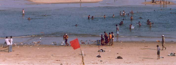
1 BEACH NOURISHMENT BY RAINBOWING FOR THE VISAKHAPATNAM PORT TRUST BY DCI Capt. MVR MURTHY ABSTRACT The coastal city of Visakhapatnam had a long wide beach. Over past three decades, this beach has progressively eroded leaving only a strip of what was once a fairly wide beach. As the continental shelf is fairly steep the erosion has exposed the rock formations which makes the beach highly dangerous for tourists / swimmers. In an effort to arrest this erosion and to protect the coast, the beach has been nourished by pumping sand from the sand trap area. Since mid 1970, this pumping of sand was carried out via a shore pipeline between the months of April to September by the dredgers of the Port and from 1990 by DCI. However, since the year 2003 the beach is being nourished by Rainbowing sand directly onto the beach front by the DCI s Trailer Suction Dredgers. This paper will highlight three important points / aspects:- a. The efforts of Visakhapatnam Port over the year to battle with the natural phenomenon called the Littoral drift silting up the Port approaches and its channels. b. The adaptation of Rainbowing technique that has resulted in the pumping of sand precisely in the zones with maximum erosion thereby making this technique effective and also reducing the time frame of the Project. c. This cost saving technique can be adapted at other locations, depending upon the requirement, so that the need to lay and maintain a fixed pipeline can be dispensed with. Key words: Beach erosion, Littoral drift, siltation & Rainbowing technique. Brief background: INTRODUCTION


 having a gap between the")

2 Fig.1 - Sand bars at the entrance channel of Vizag port This had arrested formation of sand bars at the entrance of the inner channel and improved the conditions for entry of ships. The sand formation on the seaward side of the sunken ships was by passed via a floating pipeline across the channel with the help of a Trailer Dredgers carrying out stationary dredging. However, this arrangement caused quite a bit of disruption to shipping and there was an urgent need to find a solution. Fig.2 - Sunken ships and pumping across the channel While this operation continued for many years the Port had constructed Outer Harbour betwee The Outer Harbor project envisaged the construction of an Island breakwater ( South breakwater ) having a gap between the Dolphin hill and the western head of the south breakwater to let the Littoral sand into the new sand trap area created by deepening the trap to 18.0 m. The sand trap was designed to take about 0.6 M cu.m. During the early stages the Littoral sand was collected from the new sand trap area by stationary dredging with port dredgers and then the sand was pumped through a 2 kms shore pipeline onto the southern portion of the beach. The pumping was carried out from the Dredger lay up berth at the outer harbor. 186


3 Fig.3 - Vizag Port Outer Harbor The material was pumped onto the southern portion of the beach for the north eastern currents to spread it along the coast. This activity was carried out by the Port with their own dredgers for about 15 years. Over the years as these dredgers had outlived their economic life and not able to cope up with the requirement of beach nourishment, it was outsourced to DCI. DCI has been carrying out beach nourishment for Vizag port since the year To take advantage of the north eastern currents and ensure spread of material across the beach there was a need to carry out dredging during the monsoon months i.e. June to September. Handling the dredgers during this period was extremely difficult due to strong winds and restricted space available for maneuvering. This resulted in down time due to bad weather conditions and also put the dredgers and its operations to a great amount of risk. However, DCI utilizing their skilled manpower, carried out dredging and pumping operations by this method during the monsoon period for over a decade. Later in the year 2002 it was found that the pipeline that was laid along the coast was corroded and damaged over large stretch. There was also a need to extend the length of the pipeline due to construction of new container terminal. The extended length of pipeline calls of installation of a booster to enable the TSD s to cope up with the power requirements. The frequent movements at the container terminal had resulted in idle time for the dredger which may increase with traffic over the years. Thus, the above constraints made the Port and DCI to come up with the thinking of carrying out Rainbowing directly onto the beach and dispense with the installation of booster and laying of pipeline altogether. 187

.")


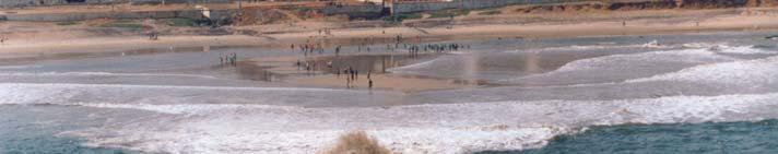
4 Fig.4 - Rainbowing for Beach Nourishment The methodology for beach nourishment by Rainbowing technique was prepared jointly by DCI and Vizag Port. It consists of filling up the hopper with sand by stationary dredging in the new sand trap area as was done earlier by the Trailer suction dredgers. The dredger would then unmoor and then steam about 1.5 Nautical miles and approach on the transits placed ashore perpendicular to the beach upto 8.0 mtrs contour. The dredger would hold her position at this point and discharge the mixture to a distance of approx 100 m so that the material falls within the 0 6 mtrs contour (the Littoral drift zone). On completion of the discharge within about 1.5 hrs the dredger returns to the new sand trap area and positions / moors for the next load. The cycle time is approx 4.5 hrs and at least 5 loads were pumped every day with cumulative quantities ranging from cu.m. per day. Direct Rainbowing onto the beach resulted in savings in time due to reduced discharge time and time loss on account of positioning (mooring / unmooring) with anchors. There is also an advantage of pumping in locations with greater erosion selectively. Further, there has been no disruption to container shipping or idle time of the dredger. This methodology had been effective for nearly three years resulting in all round benefit. However, the Tsunami during Dec.2004 made DCI Vizag Port to think of alternative methods of nourishment as the rocks that got exposed due to massive transportation of sand from the sea bed along the beach damaged the dredgers bottom shell at 8m contour. The alternative method consisted of pumping material by anchoring / mooring the dredger at around 10m depth contour with a 200 m self float line and a Rainbow pontoon. The material is pumped directly into the Littoral zone between 4 to 6 m through this Rainbow pontoon. This method proved to be quite successful in not only pumping the material to an area adjoining the existing beach but also ensured that the operations are absolutely safe. 188

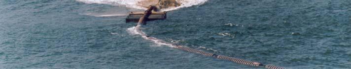
5 Fig.5 - Floating pipeline arrangement for shore pumping Fig.6 - Beach Nourishment through a Rainbow pontoon 189
6 Major results - Siltation control of approach channels - Continuation of expansion plans / progress - Preservation of beach from further erosion - Pumping of material selectively in areas of maximum erosion by Rainbowing technique - Cost savings due to Rainbowing no maintenance of pipeline - Reduced time frame of the Project Conclusions This article highlights the successful efforts of the Port over the years in tackling the siltation and preserving the beach from erosion simultaneously and also, the effectiveness and cost saving in the Project due to Rainbowing technique by DCI dredgers. This technique not only enabled the Port to dispense with the laying and maintenance of the pipeline but also reduced the time frame of the Project. The article further brings to light as to how two Government bodies DCI Vizag Port acted in a very responsible manner to use innovative methods over the years to preserve the beach. 190
Ennore Coal Port Project: Port Basin and Entrance Channel
 Ennore Coal Port Project: Port Basin and Entrance Channel André Luypaert Ennore Coal Port Project: Port Basin and Entrance Channel Abstract The Chennai Port on the eastern coast of India is the main port
Concepts & Phenomena
 Concepts & Phenomena in coastal and port sedimentation R. Kamalian Ports and Maritime Organization of Iran and PIANC-Iran 7 9 December 2015 What is the problem? Many harbours have sedimentation problems
14 NOISE AND VIBRATION
 14 NOISE AND VIBRATION 14.1 EXISTING ENVIRONMENT 14.1.1 The noise environment within Poole Harbour is generally characterised by low to medium noise levels depending on location. For example, certain areas
R. Randall Center for Dredging Studies Texas A&M University
 R. Randall Center for Dredging Studies Texas A&M University i Glory (Caisson) holes for subsea installations Pipeline trenches Deep ocean mining LNG ports & ship channels Summary WEDA 33 & TAMU 44 2 WEDA
Ocean Structures and Material Prof. Dr. Srinivasan Chandrasekaran Department of Ocean Engineering Indian Institute of Technology, Madras
 Ocean Structures and Material Prof. Dr. Srinivasan Chandrasekaran Department of Ocean Engineering Indian Institute of Technology, Madras Module - 2 Lecture - 5 Dredging II In the fifth lecture we discussed
Australian Coastal Councils Conference
 Australian Coastal Councils Conference Kiama March 2019 Where Has My Beach Gone? (and what can I do about it?) Dr Andrew McCowan Water Technology Where Has My Beach Gone? Where Has My Beach Gone? Where
DREDGING. with particular emphasis on Oil and Gas activities in Canada
 DREDGING with particular emphasis on Oil and Gas activities in Canada Dredging is an excavation activity or operation usually carried out at least partly underwater, in shallow seas or fresh water areas
Q1. What are the primary causes/contributors to coastal erosion at Westshore and the concept of longshore / littoral drift.
 Q1. What are the primary causes/contributors to coastal erosion at Westshore and the concept of longshore / littoral drift. In order of (timing related) contribution to present problem 1. Beach is too
Impacts of breakwaters and training walls
 Across the eastern seaboard of Australia, breakwaters and training walls have instigated fundamental perturbations to coastal and estuary processes. This has induced long-term changes to foreshore alignments,
MOREHEAD CITY HARBOR, NC. Dredged Material Management Plan (DMMP)
") MOREHEAD CITY HARBOR, NC Dredged Material Management Plan (DMMP) Public Meeting/Info Session 15 January 2014 US Army Corps of Engineers Morehead City Harbor DMMP Presentation Topics Morehead City Harbor
MOREHEAD CITY HARBOR, NC Dredged Material Management Plan (DMMP) Public Meeting/Info Session 15 January 2014 US Army Corps of Engineers Morehead City Harbor DMMP Presentation Topics Morehead City Harbor
HARBOUR SEDIMENTATION - COMPARISON WITH MODEL
 HARBOUR SEDIMENTATION - COMPARISON WITH MODEL ABSTRACT A mobile-bed model study of Pointe Sapin Harbour, in the Gulf of St. Lawrence, resulted in construction of a detached breakwater and sand trap to
Dredging Keeping Our Underwater Highways Open
 Dredging Keeping Our Underwater Highways Open Sedimentation Material that falls to the bottom of a liquid is called sediment. If enough sediment deposits to build a shallow spot on the river or ocean bottom,
Today: Coastal Issues and Estuaries
 Today: Coastal Issues and Estuaries Coastal issues Human effect on coastlines What is an estuary Why are they so important? Circulation of water in estuary Environmental issues Coastal Issues: Problem
SANDBANKS COAST PROTECTION
 SANDBANKS COAST PROTECTION David Robson, Senior Engineer, Coastal & Drainage Team Borough of Poole Leisure Services (T) 01202 265265 (E) d.robson@poole.gov.uk May 2003 SANDBANKS COAST PROTECTION Introduction
Nome Harbor Page 2 of 12
 Nome Harbor Nome Harbor Page 2 of 12 Condition of Improvements 30 December 2015 Nome Harbor, Alaska (CWIS No. 010422, 012270, 072742, 087755) Authorization (1) Rivers and Harbors Act, 8 August 1917 (House
Dauphin Island East End Beach and Barrier Island Restoration Project. Beau Buhring South Coast Engineers
 Dauphin Island East End Beach and Barrier Island Restoration Project Beau Buhring South Coast Engineers Funding Funded with qualified outer continental shelf oil and gas revenues by the Coastal Impact
Real Property Institute of Canada Marine Infrastructure National Workshop. A new era in dredging for Eastern Canada
 Real Property Institute of Canada Marine Infrastructure National Workshop A new era in dredging for Eastern Canada Subjects covered Definition of dredging Main dredging activities Type of dredging and
Hydrographic Surveying Methods, Applications and Uses
 Definition: Hydrographic Surveying Methods, Applications and Uses It is the branch of surveying which deals with any body of still or running water such as a lake, harbor, stream or river. Hydrographic
Ocean Waves. Capillary. Gravity. Wind generated. Tides Tsunamis Seiches
 Ocean Waves Capillary Wind generated Gravity Tides Tsunamis Seiches Capillary waves are driven by the surface tension produced by electrically polarized water molecule San Pedro Lighthouse Waves are alternate
Condition of Improvements 30 December 2014 Wrangell Harbors, Alaska (CWIS No , )
") Wrangell Harbors Condition of Improvements 30 December 2014 Wrangell Harbors, Alaska (CWIS No. 010435, 021500) Authorization (1) Rivers and Harbors Act, 22 September 1922 (House Doc. 161, 67th Congress,
Wrangell Harbors Condition of Improvements 30 December 2014 Wrangell Harbors, Alaska (CWIS No. 010435, 021500) Authorization (1) Rivers and Harbors Act, 22 September 1922 (House Doc. 161, 67th Congress,
BYPASS HARBOURS AT LITTORAL TRANSPORT COASTS
 BYPASS HARBOURS AT LITTORAL TRANSPORT COASTS by K. Mangor 1, I. Brøker 2, R. Deigaard 3 and N. Grunnet 4 ABSTRACT Maintaining sufficient navigation depth in front of the entrance at harbours on littoral
APPLICATION OF SHORE PROTECTION SCHEMES IN HORNB^K Mads Peder J0rgensen ' Peer Skaarup 2 Karsten Mangor 3 J0rgen Juhl 4
 APPLICATION OF SHORE PROTECTION SCHEMES IN HORNB^K Mads Peder J0rgensen ' Peer Skaarup 2 Karsten Mangor 3 J0rgen Juhl 4 ABSTRACT Hornbask Harbour was built more than a hundred years ago on a sandy coast
SEDIMENT BUDGET OF LIDO OF PELLESTRINA (VENICE) Written by Marcello Di Risio Under the supervision of Giorgio Bellotti and Leopoldo Franco
 Written by Marcello Di Risio Under the supervision of Giorgio Bellotti and Leopoldo Franco") SEDIMENT BUDGET OF LIDO OF PELLESTRINA (VENICE) Written by Marcello Di Risio Under the supervision of Giorgio Bellotti and Leopoldo Franco Table of contents: 1. Introduction...3 2. Protection structures
SEDIMENT BUDGET OF LIDO OF PELLESTRINA (VENICE) Written by Marcello Di Risio Under the supervision of Giorgio Bellotti and Leopoldo Franco Table of contents: 1. Introduction...3 2. Protection structures
Port Sections Guide Section 01
 s Guide 01 Cow Bay Marina Date 10/1/2016 Position (lat / lon) Minimum controlled water depth Chart datum Range of water densities Tidal range alongside Bottom type Dredging regime Distance pilot station
LAB: WHERE S THE BEACH
 Name: LAB: WHERE S THE BEACH Introduction When you build a sandcastle on the beach, you don't expect it to last forever. You spread out your towel to sunbathe, but you know you can't stay in the same spot
Admiralty Leisure Folio SC5601 East Devon and Dorset Coast, Exmouth to Christchurch
 Admiralty Leisure Folio SC5601 East Devon and Dorset Coast, Exmouth to Christchurch The Notices to Mariners (NMs) listed below apply to the latest edition of SC5601 (11 th Edition) published on 24 th March
LAKKOPETRA (GREECE) EUROSION Case Study. Contact: Kyriakos SPYROPOULOS. TRITON Consulting Engineers. 90 Pratinou Str Athens (GREECE)
 EUROSION Case Study. Contact: Kyriakos SPYROPOULOS. TRITON Consulting Engineers. 90 Pratinou Str Athens (GREECE)") LAKKOPETRA (GREECE) Contact: Kyriakos SPYROPOULOS TRITON Consulting Engineers 90 Pratinou Str. 11634 Athens (GREECE) Tel: +32 10 729 57 61 Fax: +32 10 724 33 58 e-mail: kspyropoulos@tritonsa.gr 19 1 1.
LAKKOPETRA (GREECE) Contact: Kyriakos SPYROPOULOS TRITON Consulting Engineers 90 Pratinou Str. 11634 Athens (GREECE) Tel: +32 10 729 57 61 Fax: +32 10 724 33 58 e-mail: kspyropoulos@tritonsa.gr 19 1 1.
Deep-water orbital waves
 What happens when waves approach shore? Deep-water orbital waves Fig. 9.16, p. 211 Wave motion is influenced by water depth and shape of the shoreline wave buildup zone surf zone beach Wave base deepwater
The 2017 Panama City Beaches Beach Interim Renourishment Project. Answers to Common Questions
 The 2017 Panama City Beaches Beach Interim Renourishment Project The fourth renourishment of the Panama City Beaches will be under construction during March and April 2017, with a planned completion by
The evolution of beachrock morphology and its influence on beach morphodynamics
 The evolution of beachrock morphology and its influence on beach morphodynamics Robert J. Turner Division of Natural Sciences, Southampton College, 239 Montauk Highway, Southampton, NY 11968, U.S.A. email:
1-32 NOME HARBOR, ALASKA (CWIS NOS , 87755, 12270, & 10422) Condition of Improvement 30 September 2012
 Condition of Improvement 30 September 2012") NOME HARBOR 1-32 NOME HARBOR, ALASKA (CWIS NOS. 72742, 87755, 12270, & 10422) Condition of Improvement 30 September 2012 AUTHORIZATION: (1) Rivers and Harbors Act, 8 August 1917 (House Doc. 1932, 64th
NOME HARBOR 1-32 NOME HARBOR, ALASKA (CWIS NOS. 72742, 87755, 12270, & 10422) Condition of Improvement 30 September 2012 AUTHORIZATION: (1) Rivers and Harbors Act, 8 August 1917 (House Doc. 1932, 64th
CHAPTER 134 INTRODUCTION
 CHAPTER 134 NEW JETTIES FOR TUNG-KANG FISHING HARBOR, TAIWAN Chi-Fu Su Manager Engineering Department Taiwan Fisheries Consultants, Inc. Taipei, Taiwan INTRODUCTION Tung-Kang Fishing Harbor, which is about
Ocean Structures and Materials Prof. Dr. Srinivasan Chandrasekaran Department of Ocean Engineering Indian Institute of Technology, Madras
 Ocean Structures and Materials Prof. Dr. Srinivasan Chandrasekaran Department of Ocean Engineering Indian Institute of Technology, Madras Module - 2 Lecture - 4 Dredging I (Refer Slide Time: 00:22) The
TOWN OF DENNIS 10 YR COMPREHENSIVE DREDGE PERMIT SEPTEMBER 10, 2013
 TOWN OF DENNIS 10 YR COMPREHENSIVE DREDGE PERMIT SEPTEMBER 10, 2013 WHAT IS IT? ALL NECESSARY PERMITS FOR DREDGING FOR PORTIONS OF BASS RIVER, SWAN POND RIVER, SESUIT HARBOR AND CHASE GARDEN CREEK ONE
MILE POINT TRAINING WALL JACKSONVILLE, FL. Geotextile Tube Installation
 MILE POINT TRAINING WALL JACKSONVILLE, FL Geotextile Tube Installation PROJECT DESIGN Remove portion of existing training wall Construct new eastern and western training walls Deepen new flow improvement
Port and Coastal Engineering
 Port and Coastal Engineering Developments in Science and Technology Per Bruun Editor Contents Preface,ix INTRODUCTION, 1 Transportation Infrastructure Development in Transition 6 Further Development of
Case study 64. Shoreham Harbour Shingle Bypassing and Recycling
 Case study 64. Shoreham Harbour Shingle Bypassing and Recycling Authors: Tony Parker, Uwe Dornbusch Main driver: Improved defences Project stage: Ongoing construction/operation since 1992 Photo 1: Shoreham
APPENDIX M DREDGED MATERIAL MANAGEMENT PLAN (DMMP) FINAL INTEGRATED FEASIBILITY REPORT AND ENVIRONMENTAL ASSESSMENT
 FINAL INTEGRATED FEASIBILITY REPORT AND ENVIRONMENTAL ASSESSMENT") APPENDIX M DREDGED MATERIAL MANAGEMENT PLAN (DMMP) Brazos Island Harbor, Texas Channel Improvement Study FINAL INTEGRATED FEASIBILITY REPORT AND ENVIRONMENTAL ASSESSMENT This page is intentionally left
APPENDIX M DREDGED MATERIAL MANAGEMENT PLAN (DMMP) Brazos Island Harbor, Texas Channel Improvement Study FINAL INTEGRATED FEASIBILITY REPORT AND ENVIRONMENTAL ASSESSMENT This page is intentionally left
Ninilchik Harbor Page 2 of 11
 Ninilchik Harbor Ninilchik Harbor Page 2 of 11 Condition of Improvements 31 December 2017 Ninilchik Harbor, Alaska (CWIS No. 012640, 087345) Authorization Rivers and Harbors Act, 3 July 1958 (P.L. 85-500
Implications of proposed Whanganui Port and lower Whanganui River dredging
 PO Box 637 Wanganui 4540 Attention: Rowan McGregor Dear Rowan 1 Summary We understand that it has been proposed to bring large vessels into the Port at Whanganui requiring the excavation of a channel up
Controlling Coastal erosion
 Controlling Coastal erosion Coastal Erosion Rates in the U.S. Coastal Erosion and Stabilization Economic pressures demanding the stabilization of beaches and coastlines are immense Coastal Erosion and
Eilat 's artificial lagoons project on the Red Sea - Israel R. Raviv Ir. R. Raviv, Coastal Engineering Ltd., P.O. Box 7322, z/b 37072,
 Eilat 's artificial lagoons project on the Red Sea - Israel R. Raviv Ir. R. Raviv, Coastal Engineering Ltd., P.O. Box 7322, z/b 37072, Introduction Eilat city is located in the southern part of the state
Grays Harbor Federal Project
 Grays Harbor Federal Project Elizabeth Chien Coastal Navigation Program Manager Seattle District 27 October 2016 US Army Corps of Engineers Grays Harbor Navigation Channel Inner Harbor Dredging Summer
Comparison of Predicted and Measured Shoaling at Morro Bay Harbor Entrance, California
 Comparison of Predicted and Measured Shoaling at Morro Bay Harbor Entrance, California by Edward F. Thompson, Inocencio P. DiRamos, and Robert R. Bottin, Jr. PURPOSE: This Coastal and Hydraulics Engineering
Delaware Chapter Surfrider Foundation - Indian River Inlet Monitoring
 Delaware Chapter Surfrider Foundation - Indian River Inlet Monitoring In 2012, the Delaware Surfrider Foundation Chapter formed the Surf Quality and Access Committee to focus on issues such as surf spot
Stability of Pipeline and details of Anchor blocks
 Stability of Pipeline and details of Anchor blocks For Offshore pipeline laying at Gulf of Kutch, Gujarat. Client WELSPUN (I) LTD, Gujarat EPC Contactor PATEL CONSTRUCTION CO. Consultants Prof. R. Sundaravadivelu
New Jersey Coastal Zone Overview. The New Jersey Beach Profile Network (NJBPN) 3 Dimensional Assessments. Quantifying Shoreline Migration
 3 Dimensional Assessments. Quantifying Shoreline Migration") New Jersey Coastal Zone Overview The New Jersey Beach Profile Network (NJBPN) Objectives Profile Locations Data Collection Analyzing NJBPN Data Examples 3 Dimensional Assessments Methodology Examples Quantifying
New Jersey Coastal Zone Overview The New Jersey Beach Profile Network (NJBPN) Objectives Profile Locations Data Collection Analyzing NJBPN Data Examples 3 Dimensional Assessments Methodology Examples Quantifying
MESSOLOGI LAGOON AREA (GREECE)
") MESSOLOGI LAGOON AREA (GREECE) 20 Contact: Kyriakos SPYROPOULOS TRITON Consulting Engineers 90 Pratinou Str. 11634 Athens (GREECE) Tel: +32 10 729 57 61 Fax: +32 10 724 33 58 e-mail: kspyropoulos@tritonsa.gr
MESSOLOGI LAGOON AREA (GREECE) 20 Contact: Kyriakos SPYROPOULOS TRITON Consulting Engineers 90 Pratinou Str. 11634 Athens (GREECE) Tel: +32 10 729 57 61 Fax: +32 10 724 33 58 e-mail: kspyropoulos@tritonsa.gr
Artificial headlands for coastal restoration
 Artificial headlands for coastal restoration J. S. Mani Professor, Department of Ocean Engineering, Indian Institute of Technology Madras, Chennai 636, India Abstract Construction of a satellite harbour
Earth Science Chapter 16 Section 3 Review
 Name: Class: Date: Earth Science Chapter 16 Section 3 Review Multiple Choice Identify the choice that best completes the statement or answers the question. 1. The movement of water that parallels the shore
1-32 NOME HARBOR, ALASKA (CWIS NOS , 87755, & 10422) Condition of Improvement 30 September 2009
 Condition of Improvement 30 September 2009") NOME HARBOR 1-32 NOME HARBOR, ALASKA (CWIS NOS. 72742, 87755, & 10422) Condition of Improvement 30 September 2009 AUTHORIZATION: (1) Rivers and Harbors Act, 8 August 1917 (House Doc. 1932, 64th Congress,
NOME HARBOR 1-32 NOME HARBOR, ALASKA (CWIS NOS. 72742, 87755, & 10422) Condition of Improvement 30 September 2009 AUTHORIZATION: (1) Rivers and Harbors Act, 8 August 1917 (House Doc. 1932, 64th Congress,
Dredging Stiff to Very Stiff Clay in thewielingen Using the DRACULA System on a Hopper Dredger
 Dredging Stiff to Very Stiff Clay in the Wielingen Using the Dracula System on a Hopper Dredger Stefaan Vandycke Dredging Stiff to Very Stiff Clay in thewielingen Using the DRACULA System on a Hopper Dredger
METHODS EMPLOYED IN LOCATING SOUNDINGS
 METHODS EMPLOYED IN LOCATING SOUNDINGS The soundings are located with reference to the shore traverse by observations made (i) entirely from the boat, (ii) entirely from the shore or (iii) from both. The
Available online at ScienceDirect. Procedia Engineering 116 (2015 )
") Available online at www.sciencedirect.com ScienceDirect Procedia Engineering 116 (2015 ) 320 325 8th International Conference on Asian and Pacific Coasts (APAC 2015) Department of Ocean Engineering, IIT
Available online at www.sciencedirect.com ScienceDirect Procedia Engineering 116 (2015 ) 320 325 8th International Conference on Asian and Pacific Coasts (APAC 2015) Department of Ocean Engineering, IIT
Voting should indicate preference to one option (Option 1, Option 2, or Option 3)
") Proposals for Wied Il-Buni Options being considered for proposal for the Ministry of Infrastructure to be taken up with Transport Malta following the extension of Terminal 1 by Malta Freeport Corporation.
Proposals for Wied Il-Buni Options being considered for proposal for the Ministry of Infrastructure to be taken up with Transport Malta following the extension of Terminal 1 by Malta Freeport Corporation.
Reading Material. Inshore oceanography, Anikouchine and Sternberg The World Ocean, Prentice-Hall
 Reading Material Inshore oceanography, Anikouchine and Sternberg The World Ocean, Prentice-Hall BEACH PROCESSES AND COASTAL ENVIRONMENTS COASTAL FEATURES Cross section Map view Terminology for Coastal
SWANSEA CHANNEL DREDGING TO IMPROVE NAVIGATION
 SWANSEA CHANNEL DREDGING TO IMPROVE NAVIGATION B.Morgan 1, G.Blumberg 1, A.Ling 2, H.Nelson 1 1 Royal HaskoningDHV, Sydney, NSW 2 NSW Department of Trade & Investment (Crown Lands), Newcastle, NSW Overview
ISLAND HARBOURS AND THEIR INFLUENCE ON ADJACENT SHORES
 CHAPTER 45 Leon Shirdan Director, Civil & Marine Engineering Co. Ltd. Haifa, Israel The purpose of this paper is to put forward an alternative solution to the problem of reconstitution of existing ports,
ADANI PORTS & SEZ LTD. ++ MUNDRA PORT ++ GENERAL INFORMATION
 ADANI PORTS & SEZ LTD. ++ MUNDRA PORT ++ GENERAL INFORMATION LOCATION Mundra Port is all weather, independent, commercial port with geographical and hydrological advantages on the West Coast of India,
IMPACTS OF COASTAL PROTECTION STRATEGIES ON THE COASTS OF CRETE: NUMERICAL EXPERIMENTS
 IMPACTS OF COASTAL PROTECTION STRATEGIES ON THE COASTS OF CRETE: NUMERICAL EXPERIMENTS Tsanis, I.K., Saied, U.M., Valavanis V. Department of Environmental Engineering, Technical University of Crete, Chania,
3.9 Marine Transportation
 3.9 Marine Transportation 3. Affected Environment and Environmental Analysis 3.9 Marine Transportation 3.9.1 Introduction This section describes existing marine vessel transportation within the Port, the
Summary of Water Access for Marinas and Public Boat Ramps
 Lake Tahoe Shoreline Plan Meeting Materials: Steering Committee Last Updated: 11-28-16 Summary of Water Access for Marinas and Public Boat Ramps Table 1: Marinas Buoy Field Assessment Marinas 1. North
Nearshore Sediment Transport What influences the loss of sediment on Beaches? - Waves - Winds - Tidal Currents - River discharge - Runoff
 Tides & Beaches Nearshore Sediment Transport What influences the loss of sediment on Beaches? - Waves - Winds - Tidal Currents - River discharge - Runoff Oceans Ocean Topography Physical Structure of the
Certified Professionals in Hydrographic Solutions
 Certified Professionals in Hydrographic Solutions Client Satisfaction is our Deliverable Port of Brisbane Pty Ltd Port Surveys Certified Professionals in Hydrographic Surveying Tel +61 (0) 7 3258 4820
Beach profile surveys and morphological change, Otago Harbour entrance to Karitane May 2014 to June 2015
 Beach profile surveys and morphological change, Otago Harbour entrance to Karitane May 2014 to June 2015 Prepared for Port Otago Ltd Martin Single September 2015 Shore Processes and Management Ltd Contact
SPECIALISED SERVICES. Kris Vlaeminck, Jan De Nul Group, Luxembourg, explains the use of dredging vessels on the Macedon Project in Australia.
 SPECIALISED SERVICES Kris Vlaeminck, Jan De Nul Group, Luxembourg, explains the use of dredging vessels on the Macedon Project in Australia. Figure 1. Shore approach for the Macedon project in Australia.
30 DAY PUBLIC NOTICE MAINTENANCE DREDGING OF THE 8-FOOT CHANNEL OF THE FEDERAL NAVIGATION PROJECT IN KENNEBUNK RIVER KENNEBUNK & KENNEBUNKPORT, ME
 fr.iiif.i ~ US Anny Corps of Engineers New England District 696 Virginia Road Concord, MA 01742-2751 Public Notice In Reply Refer to: Mr. Jack Karalius nae-pn-nav@usace.army.mil Programs/Project Management
Feasibility Study for Dredging of Khaprabhanga Chapalir Don River in Patuakhali District for Improvement of Navigability
 IOSR Journal of Engineering (IOSRJEN) ISSN (e): 2250-3021, ISSN (p): 2278-8719 Vol. 04, Issue 06 (June. 2014), V3 PP 32-38 www.iosrjen.org Feasibility Study for Dredging of Khaprabhanga Chapalir Don River
World Shipping Council. Bureau of Ocean Energy Management
 Comments of the World Shipping Council Submitted to the Bureau of Ocean Energy Management In the matter of Potential Commercial Leasing for Wind Power on the Outer Continental Shelf (OCS) Offshore New
DREDGING AT INLETS ON SANDY COASTS
 CHAPTER 18 DREDGING AT INLETS ON SANDY COASTS Berkeley Blackman Chief, Civil Works Branch South Atlantic Division, Corps of Engineers Department of the Army Atlanta, Georgia Dredging in navigation channels
CORPS FACTS. Harbor Dredging U.S. ARMY CORPS OF ENGINEERS BUILDING STRONG
 CORPS FACTS Harbor Dredging U.S. ARMY CORPS OF ENGINEERS BUILDING STRONG Disaster Response Sedimentation in the channel is caused by the normal cycle of silt movement, erosion from high water or heavy
Maltester Channel Dredging. Shoreline Marina Committee. November 18, 2008
 Maltester Channel Dredging Shoreline Marina Committee November 18, 2008 Shoaling Study Summary Report Completed in October 2008 Analyzed siltation rates at Marina Rate of siltation is dynamic ranging from
MULTIDECADAL SHORELINE EVOLUTION DUE TO LARGE-SCALE BEACH NOURISHMENT JAPANESE SAND ENGINE? Abstract
 MULTIDECADAL SHORELINE EVOLUTION DUE TO LARGE-SCALE BEACH NOURISHMENT JAPANESE SAND ENGINE? Masayuki Banno 1, Satoshi Takewaka 2 and Yoshiaki Kuriyama 3 Abstract Beach nourishment is one of the countermeasures
NOTICE TO MARINERS. No 60(T) of Port of Southampton Southampton Boat Show, River Test 16 th to 25 th September 2016
 of Port of Southampton Southampton Boat Show, River Test 16 th to 25 th September 2016") NOTICE TO MARINERS No 60(T) of 2016 Port of Southampton Southampton Boat Show, River Test 16 th to 25 th September 2016 NOTICE IS HEREBY GIVEN that the Southampton Boat Show will take place on and adjacent
NOTICE TO MARINERS No 60(T) of 2016 Port of Southampton Southampton Boat Show, River Test 16 th to 25 th September 2016 NOTICE IS HEREBY GIVEN that the Southampton Boat Show will take place on and adjacent
INFORMATION SHEET NOOSA MAIN BEACH ARTIFICIAL REEF PROPOSAL
 INFORMATION SHEET NOOSA MAIN BEACH ARTIFICIAL REEF PROPOSAL 1. BACKGROUND Background information on the history of erosion at Noosa Main Beach is well documented in the technical paper prepared by P. Coughlin,
Inlet Management Study for Pass-A-Grille and Bunces Pass, Pinellas County, Florida
 Inlet Management Study for Pass-A-Grille and Bunces Pass, Pinellas County, Florida Final Report Submitted By Ping Wang, Ph.D., Jun Cheng Ph.D., Zachary Westfall, and Mathieu Vallee Coastal Research Laboratory
Follets Island Nearshore Beach Nourishment Project
 Coast & Harbor Engineering A division of Hatch Mott MacDonald Follets Island Nearshore Beach Nourishment Project Arpit Agarwal, P.E. April 1, 2016 Project Site!"#$% &'(% &)*+% )#,'-+% Shoreline Erosion
TITLE: North Carolina s Changing Shorelines. KEYWORDS: erosion - shorelines - mapping - sustainability
 UNC Coastal Studies Institute Teacher Resources 1 TITLE: North Carolina s Changing Shorelines KEYWORDS: erosion - shorelines - mapping - sustainability Changing shorelines impact coastal infrastructure.
Port of Zeebrugge: Upgrading the Brittannia Dock
 ABSTRACT Port of Zeebrugge: Upgrading the Brittannia Dock by L. Missinne 1 and L. Van Damme 2 The Flemish authority started with the upgrading of the Brittannia Dock in the port of Zeebrugge. The Brittannia
4/20/17. #31 - Coastal Erosion. Coastal Erosion - Overview
 Writing Assignment Due Monday by 11:59 pm #31 - Coastal Erosion Beach front property! Great View! Buy now at a great price! See main class web pages for detailed instructions Essays will be submitted in
Planning of Major Recreational Boating Facilities at Shell Cove Boat Harbour
 Planning of Major Recreational Boating Facilities at Shell Cove Boat Harbour B Morgan 1, Deborah Lam 1, Glenn Colquhoun 2 1 Advisian, Sydney, NSW 2 Frasers Property Australia, Shell Cove, NSW Abstract
3 Maps and Charts In order to navigate we need to use some form of map. The two choices are nautical charts, or land maps.
 13 3 Maps and Charts In order to navigate we need to use some form of map. The two choices are nautical charts, or land maps. Charts Nautical Charts only show the land detail that is visible from the sea.
Building Coastal Resiliency at Plymouth Long Beach
 Building Coastal Resiliency at Plymouth Long Beach Department of Marine and Environmental Affairs March 30, 2017 Introducing Green Infrastructure for Coastal Resiliency Plymouth Long Beach & Warren s Cove
Dare County Nourishment Project Town of Duck
 Dare County Nourishment Project Town of Duck Julien Devisse, P.E. and Ken Willson CB&I / Coastal Planning & Engineering of North Carolina, Inc. February 15, 2017 A World of Solutions Outline Background
Chittagong, Bangladesh (Asia Region)
") General Information: Port Information (Asia Region) Extract of port information from Chittagong Port Authority: The Port of Chittagong is the principal Port of the People's Republic of Bangladesh. It is
General Information: Port Information (Asia Region) Extract of port information from Chittagong Port Authority: The Port of Chittagong is the principal Port of the People's Republic of Bangladesh. It is
Volume and Shoreline Changes along Pinellas County Beaches during Tropical Storm Debby
 Volume and Shoreline Changes along Pinellas County Beaches during Tropical Storm Debby Ping Wang and Tiffany M. Roberts Coastal Research Laboratory University of South Florida July 24, 2012 Introduction
Puducherry Port Disaster. A Man-Made Made Tsunami. Coastal Erosion at Puducherry. & neighboring beaches of Tamil Nadu
 Puducherry Port Disaster A Man-Made Made Tsunami Coastal Erosion at Puducherry & neighboring beaches of Tamil Nadu Pondicherry Citizens Action Network February 2007 Once upon a time Pondicherry had a beautiful
(Refer Slide Time: 0:36)
") Port and Harbour Structures. Professor R. Sundaradivelu. Department of Ocean Engineering. Indian Institute of Technology, Madras. Module-2. Lecture-8B. Wave Rose Diagram. (Refer Slide Time: 0:36) We will
Port and Harbour Structures. Professor R. Sundaradivelu. Department of Ocean Engineering. Indian Institute of Technology, Madras. Module-2. Lecture-8B. Wave Rose Diagram. (Refer Slide Time: 0:36) We will
Figure79. Location map for the 10 NJBPN profile sites in Atlantic County, NJ 155
 154 Figure79. Location map for the 10 NJBPN profile sites in Atlantic County, NJ 155 ATLANTIC COUNTY SPRING 2009 to FALL 2010 The Atlantic County coastline consists of three barrier islands. Between Little
INTRODUCTION TO COASTAL ENGINEERING
 The University of the West Indies Organization of American States PROFESSIONAL DEVELOPMENT PROGRAMME: COASTAL INFRASTRUCTURE DESIGN, CONSTRUCTION AND MAINTENANCE A COURSE IN COASTAL DEFENSE SYSTEMS I CHAPTER
The Dynamic Coast. Right Place Resources. A presentation about the interaction between the dynamic coast and people
 The Dynamic Coast Houses threatened by coastal erosion in California Right Place Resources A presentation about the interaction between the dynamic coast and people For the rest of the presentations in
Life COAST-BEST ENV/IT 426
 Life COAST-BEST ENV/IT 426 Envisan N.V. Final report - engl 1/30 ACTION 2.8. Review of appropriate dredging techniques on the basis of environmental and economic issues TABLE OF CONTENTS Table of Contents...
MANERI DAM D/S VIEW. Er. SANDEEP SINGHAL Director (Projects) UJVN Limited, Dehradun, (UK)
 UJVN Limited, Dehradun, (UK)") COMPREHENSIVE REHABILITATION / REPAIR OF MANERI DAM IN DIST. UTTARKASHI MANERI DAM D/S VIEW Er. SANDEEP SINGHAL Director (Projects) UJVN Limited, Dehradun, (UK) sandysinghal14@hotmail.com ABSTRACT Severe
COMPREHENSIVE REHABILITATION / REPAIR OF MANERI DAM IN DIST. UTTARKASHI MANERI DAM D/S VIEW Er. SANDEEP SINGHAL Director (Projects) UJVN Limited, Dehradun, (UK) sandysinghal14@hotmail.com ABSTRACT Severe
Chapter 4 EM THE COASTAL ENGINEERING MANUAL (Part I) 1 August 2008 (Change 2) Table of Contents. Page. I-4-1. Background...
 1 August 2008 (Change 2) Table of Contents. Page. I-4-1. Background...") Chapter 4 EM 1110-2-1100 THE COASTAL ENGINEERING MANUAL (Part I) 1 August 2008 (Change 2) Table of Contents I-4-1. Background... Page I-4-1 a. Shore Protection Planning and Design, TR 4... I-4-1 b. Shore
Chapter 4 EM 1110-2-1100 THE COASTAL ENGINEERING MANUAL (Part I) 1 August 2008 (Change 2) Table of Contents I-4-1. Background... Page I-4-1 a. Shore Protection Planning and Design, TR 4... I-4-1 b. Shore
STATE OF THE COAST 2016 Coastal Frontiers Corporation June 1, 2017
 STATE OF THE COAST 2016 Coastal Frontiers Corporation June 1, 2017 Shoreline Preservation Committee 1. Background OVERVIEW 2. Monitoring Program 3. Results 2015-16 El Niño Post-RBSP II Post-RBSP I 4. Conclusions
COASTAL MANAGEMENT AND PROTECTION METHODS! 1
 COASTAL MANAGEMENT AND PROTECTION METHODS! 1 Strategy What it does Cons Pros Examples SOFT ENGINEERING: The use of ecological principles and practices to reduce erosion and achieve the stabilization and
PRESSURE EQUALISATION MODULES FOR ENVIRONMENTALLY FRIENDLY COASTAL PROTECTION
 PRESSURE EQUALISATION MODULES FOR ENVIRONMENTALLY FRIENDLY COASTAL PROTECTION Poul Jakobsen Skagen Innovation Centre, Dronning Alexandrinesvej 7, DK - 999 Skagen, Denmark Abstract Land-based activities
Evaluation Report Teluk Chempedak Oct 2005
 Evaluation Report Teluk Chempedak Oct 2005 Beach Nourishment combined with the SIC System Hyatt Hotel SIC Skagen Innovation Centre Dr. Alexandrinesvej 75 Dk 9990 Skagen Denmark Phone 00 45 98 44 57 13
CHAPTER 81 VARIATION OF TOPOGRAPHY OF SEA-BED CAUSED BY THE CONSTRUCTION OF BREAKWATERS
 CHAPTER 81 VARIATION OF TOPOGRAPHY OF SEA-BED CAUSED BY THE CONSTRUCTION OF BREAKWATERS Shoji Sato and Isao Irie Hydraulics Division, Port and Harbour Research Institute Ministry of Transport 1-1, 3 Chome,
1.5 Understand how ocean waves and currents change the face of coastal areas. (Chapter 3)
") 1.5 Understand how ocean waves and currents change the face of coastal areas. (Chapter 3) 1. Hydraulic Action/Pressure - air being forced into crack in rocks. 2. Corrosion (Solution) Minerals such as calcium
1.5 Understand how ocean waves and currents change the face of coastal areas. (Chapter 3) 1. Hydraulic Action/Pressure - air being forced into crack in rocks. 2. Corrosion (Solution) Minerals such as calcium