Eilat 's artificial lagoons project on the Red Sea - Israel R. Raviv Ir. R. Raviv, Coastal Engineering Ltd., P.O. Box 7322, z/b 37072,
|
|
|
- Blanche Bell
- 5 years ago
- Views:
Transcription
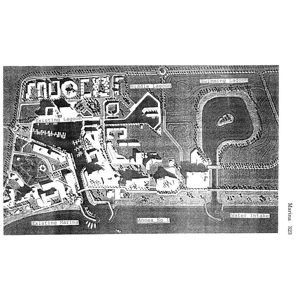
1 Eilat 's artificial lagoons project on the Red Sea - Israel R. Raviv Ir. R. Raviv, Coastal Engineering Ltd., P.O. Box 7322, z/b 37072, Introduction Eilat city is located in the southern part of the state of Israel on the coast line of the Red-Sea, 10 Km west of Aqaba city in Jordan. The Red Sea is one of the most interesting seas in the world for scuba diving and it makes Eilat the most attractive area for recreation in Israel. Swimming, scuba diving, sailing, water skiing, wind surfing and other recreation activities can be enjoyed in Eilat throughout the whole year. In the year 1992 it was decided by the Eilat Foreshore Development Company Ltd. which is a government company to continue with the realisation of the master plan consisting of the Artificial Lagoons project. The building of the project will enable the company to provide more areas for building hotels (3,000 rooms), enlarging the existing marina, and providing more swimming area by adding a 1000 meters length of water line with sandy beaches. Construction works were started in September 1993 and are expected to be finished in September Project Description The project includes: A swimming lagoon, called the eastern lagoon. This lagoon is connected to the sea by a canal 300 meters long which is bridged by two bridges. One bridge for pedestrians, close to the coast line and one a traffic bridge near the lagoon. A sail ing lagoon, called the middle lagoon with a peninsula. This lagoon is connected to the existing lagoon on the west side of the project (which was constructed 30 years ago) by a canal. This canal is also bridged by two bridges. One moveable bridge for heavy traffic and one moveable bridge for pedestrians. The existing western lagoon is an inner marina surrounded by
2 320 Marina hotels. This lagoon is connected to the open sea by a canal and an outer marina. This canal is also bridged by a pedestrians moveable bridge. The total berths in the middle lagoon together with the existing western lagoon and the existing outer marina are 500 places. Design Data Waves: From south direction. 2-3 meters significant heights with period of 6 to 7 seconds, wind force of 40 knots and effective fetch up to 150 nautical miles. Storms: 3 to 5 times per year during winter time: December- February, with a duration of 1 or 2 days only. Tide: meter; meter, once per year meter; meter, once per 10 years meter; meter, once per 25 years. Design Requirements Swimming - Eastern Lagoon 1. Water quality will be controlled by the daily tide fluctuation and must comply with Israel Ministry of Health requirements. 2. The slopes 1:15 to 1:20 will be covered by 50cm sand layers. 3. Water depth 2.5 meters maximum. Middle Lagoon 1. The peninsula will be built with vertical walls. ^ 2. Vertical kg/m\ surcharge load for the walls: 500 kg/m to The surroundings stones. will be built with slopes 1:3.5 covered by 4. The water quality fluctuation. will be controlled by the daily tide 5. Water depths 2.5 meters. 6. Jetties supported on piles. Canals The slopes will be built 1:3.5. Water depth 2.5 meters. 3. Water velocity maximum 0.15 meter/second. Breakwaters for water intake for swimming - Eastern Lagoon 1. Will be built from local red granite stones. 2. Water depth at the entrance 2.5 meters.
3 Typical design crossection of the project 1. Swimming ff Eastern Lagoon Marina 321 a. Slopes of 1:20 or 1:15 in relation to walking safely into water and minimizing the maintenance of the 50 cm sand layer. b. The sand grains diameter 0.42mm to 0.85mm, to prevent being blawn by the wind and due to marine biological requirements. 2. Middle Lagoon a. Vertical walls - Quay walls are designed from deep diaphragm walls. 60cm thick. The soil consists of sand and clay layers. The horizontal cross sections of the walls can be straight or T shaped if necessary. b. Total walls length in the project 500 meters. Wall thickness 60cm and wall length varies from 12 meters to 14 meters. 3. Bridges a. All bridges are based on deep diaphragm walls straight or T shaped with 60cm thickness. b. Moveable parts are designed according to Dutch standards and manufactured in the Netherlands. Special construction problems 1. The lagoons were excavated in dry conditions. The groundwater surface was lowered by well points at the beginning of the work and immediately after were kept low by open air pumping. The ground water surface was lowered 3 meters on the whole surface of the lagoons, so all works could be done 2. in dry conditions, between the elevation +3.0 meters above sea level and -3.0 meters under sea level. 800,000 cubic meters of earth was removed and spread around the project in compacted layers of 30cm thick. This was done in order to create new landscape around the project. 3. During the canals excavations the foundations of 4 bridges and 200 meters jetty were executed by diaphragm walls. 4. The front side of the diaphragm walls was covered by 3 cm of finish layer of torquecrete between the elevation meter and -1.0 meter. This was done while the middle Lagoon and the canals were still dry by continuous pumping of groundwater. Above the elevation the concrete was poured in moulds.
4 322 Marina Contractors and tenders The project was tendered in stages because the design was done by stages. It was done, of course, according to an approved master plan for this area of Eilat. The first stage of the project which was tendered includes: The Lagoons, Canals, Breakwaters of the water intake of the Swimming - Eastern Lagoon, Diaphragms walls: For quay-walls, jetties, bridge foundations. All of that up to the elevation +1.5 meter above sea-level. This elevation was chosen to enable to dig the lagoons and canals without interference while constructing the bridges. This tender was given to one contractor to be constructed during a period of 24 months. The second stage of the project which was tendered a few months later includes the parallel construction of the four bridges, from the elevation of +1.5 meter above sea level up to the final elevation of each bridge as designed. During the construction period of this huge project, "life" was going on in that concentrated tourist area with 3,500 hotel rooms. This with a lot of patience, exact and sharp working schedule, while using special fence - curtains, trying to keep the view as nice as possible. Project plan's and photos Annexed to this project description one can see the following: Annex No 1: A photo of the project maquet. Annex No 2: A map of the Red Sea showing Eilat and Aqaba. Annex No 3: Typical cross section of the Eastern - Swimming Lagoon. Annex No 4: Typical cross section of canal and breakwaters for water intake to the swimming Lagoon. Annex No 5: Typical cross section of the Inner Lagoon. Annex No 6: Typical cross section of the Sailing canal between the Western-Existing Lagoon and the Middle Lagoon. Annex No 7: Typical side view of the Moveable Traffic Bridge. Annex No 8: Typical side view of a Moveable Pedestrians Bridge. Annex No 9: Typical side view of a fixed Traffic Bridge. Annex No 10: Typical side view of a fixed pedestrians Bridge. Annex No 11: Typical cross section of a jetty and Bridge. Annex No 12: Typical side view of a jetty and Bridge. Annex No 13: Typical cross section existing western lagoon. of a quay-wall in the
5 CO K) CO
6 324 Marina Annex Mo 2= A nap of the Red Sea showing Ellt and Aqaba. Annex No 4:_Topical cross sections of canal and breakwaters for water-intake tc the su.nning LuQOon. Inland p.00 Annex ho 3: "fypycal cress section of the Eastern - Suinning Lagoon.
7 Marina 325 Annex Mo 8-' Tupical side view of Q Moveable Pedestrians Bridge
8 326 Marina Annex 1?: Typical. Sioie View of c jetty and bridge. \ Annex No 13: Typical cress sections of a Jettu and bridge. Annex 13: A Typical Cross section of a quay wall in the existing Western Lagoon.
The Case of the Disappearing Shoreline
 Name The Case of the Disappearing Shoreline Humans change the earth's climate in many ways. One change is the increase of carbon dioxide in the atmosphere. As we burn more fossil fuels, we release more
Controlling Coastal erosion
 Controlling Coastal erosion Coastal Erosion Rates in the U.S. Coastal Erosion and Stabilization Economic pressures demanding the stabilization of beaches and coastlines are immense Coastal Erosion and
European Handball Federation TM EHF Beach Handball Commission
 Beach Handball Court Construction Guide EHF Promotion and Development Vienna, March 2016 1 Guide topics Location Court, markings Goals, lines Construction Sand quality requirements Lighting requirements
Montessori for Everyone 2013 Types of Coastlines
 Coast The coast is the part of the land that borders the sea. It is subject to constant change, as the result of the waves and deposits carried by water onto the land. Coastline The coastline is where
LAKKOPETRA (GREECE) EUROSION Case Study. Contact: Kyriakos SPYROPOULOS. TRITON Consulting Engineers. 90 Pratinou Str Athens (GREECE)
 EUROSION Case Study. Contact: Kyriakos SPYROPOULOS. TRITON Consulting Engineers. 90 Pratinou Str Athens (GREECE)") LAKKOPETRA (GREECE) Contact: Kyriakos SPYROPOULOS TRITON Consulting Engineers 90 Pratinou Str. 11634 Athens (GREECE) Tel: +32 10 729 57 61 Fax: +32 10 724 33 58 e-mail: kspyropoulos@tritonsa.gr 19 1 1.
LAKKOPETRA (GREECE) Contact: Kyriakos SPYROPOULOS TRITON Consulting Engineers 90 Pratinou Str. 11634 Athens (GREECE) Tel: +32 10 729 57 61 Fax: +32 10 724 33 58 e-mail: kspyropoulos@tritonsa.gr 19 1 1.
REVETMENTS. Purposes and Operational Constraints. Purposes Erosion control o o. Revetment Design 4/5/2016. CE A676 Coastal Engineering
 REVETMENTS Ijsseldam, the Netherlands Orson P. Smith, PE, Ph.D. Instructor Purposes and Operational Constraints Purposes Erosion control o o Embankment Toe protection for a seawall, retaining wall or other
Port of Zeebrugge: Upgrading the Brittannia Dock
 ABSTRACT Port of Zeebrugge: Upgrading the Brittannia Dock by L. Missinne 1 and L. Van Damme 2 The Flemish authority started with the upgrading of the Brittannia Dock in the port of Zeebrugge. The Brittannia
HARBOUR SEDIMENTATION - COMPARISON WITH MODEL
 HARBOUR SEDIMENTATION - COMPARISON WITH MODEL ABSTRACT A mobile-bed model study of Pointe Sapin Harbour, in the Gulf of St. Lawrence, resulted in construction of a detached breakwater and sand trap to
6/19/2006 The Reef Ball Foundation 1
 6/19/2006 The Reef Ball Foundation 1 Overview Reef Balls are prefabricated concrete modules used as a base for natural coral reefs to form. Reef Balls have been used in 55 countries in over 3,500 projects
ITEM 400 STRUCTURAL EXCAVATION AND BACKFILL
 AFTER MARCH 1, 2012 ITEM 400 STRUCTURAL EXCAVATION AND BACKFILL 400.1 Description. This item shall govern for all excavation required for the construction of all structures, except pipe or box sewers for
NORTH HAVEN NORTH HAVEN SLSC
 NORTH HAVEN NORTH HAVEN SLSC Patrols: November to March, weekends and public holidays North Haven beach is the product of a major redevelopment of the northern part of the Adelaide coast. In the 1980s,
AD-A II~lllII I I 7
 AD-A284 157 II~lllII CONSTRUCTION OF BREAK WATERS AND BEACEFILL AT THE NAVAL AIR STATION, PATUXENT RIVER, MARYLAND C D.W.Yang, J.McWilliams 2, S.Ming 2 ABSTRACT Construction of the breakwaters and beach
3.9 FROM ISLANDS TO ATOLLS
 3.9 1 3.9 FROM ISLANDS TO ATOLLS OBJECTIVES The students Listen to a description of the formation of volcanic islands, fringing reefs, barrier reefs, and atolls. Observe and participate in a simulation
Figure 4, Photo mosaic taken on February 14 about an hour before sunset near low tide.
 The Impact on Great South Bay of the Breach at Old Inlet Charles N. Flagg and Roger Flood School of Marine and Atmospheric Sciences, Stony Brook University Since the last report was issued on January 31
MIRABAY PILOT PROJECT REPORT
 MIRABAY PILOT PROJECT REPORT 9/25/2014 By: Ingenium, Inc./Carl A. Hazenberg, P.E. Seawalls along the MiraBay canal system started experiencing problems shortly after construction. Following the issues,
4/20/17. #30 - Coastlines - General Principles Coastlines - Overview
 Writing Assignment Due one week from today by 11:59 pm See main class web pages for detailed instructions Essays will be submitted in Illinois Compass (instructions later) Pick one: Earthquakes, tsunamis,
Redondo Beach Boat Launch Ramp Facility
 Redondo Beach Boat Launch Ramp Facility Feasibility Report for the California Department of Boating and Waterways 2015 Grant Cycle For the City of Redondo Beach Submitted by March 13, 2014 Table of Contents
OCEAN WAVES NAME. I. Introduction
 NAME OCEAN WAVES I. Introduction The physical definition of a wave is a disturbance that transmits energy from one place to another. In the open ocean waves are formed when wis blowing across the water
Overview. Beach Features. Coastal Regions. Other Beach Profile Features. CHAPTER 10 The Coast: Beaches and Shoreline Processes.
 Overview CHAPTER 10 The Coast: Beaches and Shoreline Processes Coastal regions constantly change. The beach is a dominant coastal feature. Wave activity continually modifies the beach and coastal areas.
LAB: WHERE S THE BEACH
 Name: LAB: WHERE S THE BEACH Introduction When you build a sandcastle on the beach, you don't expect it to last forever. You spread out your towel to sunbathe, but you know you can't stay in the same spot
Planning of Major Recreational Boating Facilities at Shell Cove Boat Harbour
 Planning of Major Recreational Boating Facilities at Shell Cove Boat Harbour B Morgan 1, Deborah Lam 1, Glenn Colquhoun 2 1 Advisian, Sydney, NSW 2 Frasers Property Australia, Shell Cove, NSW Abstract
Anatomy of Coastal Regions
 The Coast I. BEACH ANATOMY Anatomy of Coastal Regions Terms for different parts of beaches and coastal regions Are all about ENERGY- ie, where the ocean s energy Mostly through tides and waves, and shape
Port Sections Guide Section 01
 s Guide 01 Cow Bay Marina Date 10/1/2016 Position (lat / lon) Minimum controlled water depth Chart datum Range of water densities Tidal range alongside Bottom type Dredging regime Distance pilot station
Essentials of Oceanography Eleventh Edition
 Chapter Chapter 1 10 Clickers Lecture Essentials of Oceanography Eleventh Edition The Coast: Beaches and Shoreline Processes Alan P. Trujillo Harold V. Thurman Chapter Overview Coastal regions have distinct
page - Laboratory Exercise #5 Shoreline Processes
 page - Laboratory Exercise #5 Shoreline Processes Section A Shoreline Processes: Overview of Waves The ocean s surface is influenced by three types of motion (waves, tides and surface currents). Shorelines
Impacts of breakwaters and training walls
 Across the eastern seaboard of Australia, breakwaters and training walls have instigated fundamental perturbations to coastal and estuary processes. This has induced long-term changes to foreshore alignments,
BEACH NOURISHMENT BY RAINBOWING FOR THE VISAKHAPATNAM PORT TRUST BY DCI. Capt. MVR MURTHY ABSTRACT
 BEACH NOURISHMENT BY RAINBOWING FOR THE VISAKHAPATNAM PORT TRUST BY DCI Capt. MVR MURTHY ABSTRACT The coastal city of Visakhapatnam had a long wide beach. Over past three decades, this beach has progressively
OECS Regional Engineering Workshop September 29 October 3, 2014
 B E A C H E S. M A R I N A S. D E S I G N. C O N S T R U C T I O N. OECS Regional Engineering Workshop September 29 October 3, 2014 Coastal Erosion and Sea Defense: Introduction to Coastal/Marine Structures
A: Formalities. DELOS WP 1.1 Inventory on LCS, questionnaire, detailed description, revision D AUTH GR. Participant code and who to contact.
 A: Formalities Participant code and who to contact. AUTH GR J. Avgeris E-mail iavgeris@civil.auth.gr This date (today, mm:dd:yyyy) and revision number (A..Z). 17/09/01 Rev A Location of LCS. Patras Gulf,
Cross-shore sediment transports on a cut profile for large scale land reclamations
 Cross-shore sediment transports on a cut profile for large scale land reclamations Martijn Onderwater 1 Dano Roelvink Jan van de Graaff 3 Abstract When building a large scale land reclamation, the safest
Construction Dewatering
 Construction Dewatering Introduction The control of groundwater is one of the most common and complicated problems encountered on a construction site. Construction dewatering can become a costly issue
VENICE LOCAL COASTAL PROGRAM UPDATE: COASTAL HAZARDS WELCOME
 VENICE LOCAL COASTAL PROGRAM UPDATE: COASTAL HAZARDS WELCOME 1 Introducing the Team Hosted by the Department of City Planning and grant funded in part by the California Coastal Commission 2 Workshop Purpose
Natural Bridges Field Trip Activity
 Natural Bridges Field Trip Activity This is due in class on MONDAY- March 1 - not in sections! Name TA: NOTE ON THE GRADING OF THIS ASSIGNMENT: Many of the questions below (especially in the tidepool part)
WIND SPEED LENGTH OF TIME WIND BLOWS (Duration) DISTANCE OVER WHICH IT BLOWS (Fetch)
 DISTANCE OVER WHICH IT BLOWS (Fetch)") WAVES Up and down movement of ocean surface Transportation of energy across the water over vast distances If not stopped by anything, waves can travel entire oceans Size and speed depend upon: WIND SPEED
WAVES Up and down movement of ocean surface Transportation of energy across the water over vast distances If not stopped by anything, waves can travel entire oceans Size and speed depend upon: WIND SPEED
NOTICE TO MARINERS. No 17 of Diving at Work Regulations 1997 and Commercial Operations Involving Swimmers
 NOTICE TO MARINERS No 17 of 2016 (Update and Re-Issue of Notice to Mariners No 17 of 2014) Diving at Work Regulations 1997 and Commercial Operations Involving Swimmers 1 NOTICE IS HEREBY GIVEN that all
Concepts & Phenomena
 Concepts & Phenomena in coastal and port sedimentation R. Kamalian Ports and Maritime Organization of Iran and PIANC-Iran 7 9 December 2015 What is the problem? Many harbours have sedimentation problems
Annex E Bridge Pier Protection Plan
 Annex E Bridge Pier Protection Plan Table E1 Bridge Types and Locations Table E2 Flow Conditions For River Sections Figure E1 Bridge Abutment Protection Figure E2 Bridge Pier Protection Figure E3 Central
Delaware Chapter Surfrider Foundation - Indian River Inlet Monitoring
 Delaware Chapter Surfrider Foundation - Indian River Inlet Monitoring In 2012, the Delaware Surfrider Foundation Chapter formed the Surf Quality and Access Committee to focus on issues such as surf spot
Case Studies Georg Umgiesser and Natalja Čerkasova KU, Lithuania
 Case Studies Georg Umgiesser and Natalja Čerkasova KU, Lithuania Case 1: A beach in the Curonian Lagoon 1 Beach Current situation in Curonian lagoon Beach in Kintai In the past, especially in Baltic inner
Hydrodynamic and hydrological modelling to support the operation and design of sea ports
 Hydrodynamic and hydrological modelling to support the operation and design of sea ports Data needs and examples Martijn de Jong (port/nautical requirements, waves, currents) Sofia Caires (mean and extreme
MESSOLOGI LAGOON AREA (GREECE)
") MESSOLOGI LAGOON AREA (GREECE) 20 Contact: Kyriakos SPYROPOULOS TRITON Consulting Engineers 90 Pratinou Str. 11634 Athens (GREECE) Tel: +32 10 729 57 61 Fax: +32 10 724 33 58 e-mail: kspyropoulos@tritonsa.gr
MESSOLOGI LAGOON AREA (GREECE) 20 Contact: Kyriakos SPYROPOULOS TRITON Consulting Engineers 90 Pratinou Str. 11634 Athens (GREECE) Tel: +32 10 729 57 61 Fax: +32 10 724 33 58 e-mail: kspyropoulos@tritonsa.gr
R. Randall Center for Dredging Studies Texas A&M University
 R. Randall Center for Dredging Studies Texas A&M University i Glory (Caisson) holes for subsea installations Pipeline trenches Deep ocean mining LNG ports & ship channels Summary WEDA 33 & TAMU 44 2 WEDA
MONITORING SEDIMENT TRANSPORT PROCESSES AT MANAVGAT RIVER MOUTH, ANTALYA TURKEY
 COPEDEC VI, 2003 in Colombo, Sri Lanka MONITORING SEDIMENT TRANSPORT PROCESSES AT MANAVGAT RIVER MOUTH, ANTALYA TURKEY Isikhan GULER 1, Aysen ERGIN 2, Ahmet Cevdet YALCINER 3 ABSTRACT Manavgat River, where
Nearshore Dredged Material Placement Pilot Study at Noyo Harbor, CA
 1 Nearshore Dredged Material Placement Pilot Study at Noyo Harbor, CA Noyo Cove N 2011 National Conference on Beach Preservation Technology 9-11, February 2011 Lihwa Lin, Honghai Li, Mitchell Brown US
Australian Coastal Councils Conference
 Australian Coastal Councils Conference Kiama March 2019 Where Has My Beach Gone? (and what can I do about it?) Dr Andrew McCowan Water Technology Where Has My Beach Gone? Where Has My Beach Gone? Where
Ennore Coal Port Project: Port Basin and Entrance Channel
 Ennore Coal Port Project: Port Basin and Entrance Channel André Luypaert Ennore Coal Port Project: Port Basin and Entrance Channel Abstract The Chennai Port on the eastern coast of India is the main port
BYLAW NUMBER
 THE CORPORATION OF THE TOWN OF MONO BYLAW NUMBER 2011-46 BEING A BYLAW RELATING TO FENCES ENCLOSING PRIVATELEY OWNED OUTDOOR SWIMMING POOLS WHEREAS section 210, paragraph 30 of the Municipal Act (R.S.O.
Muizenberg Accessibility: Removing barriers to public spaces.
 Muizenberg Accessibility: Removing barriers to public spaces. Refer to SANS 10400-S:2011 Edition 3 of the building code. Note: Facilities that are not in accordance with the requirements of this part of
Ocean Waves. Capillary. Gravity. Wind generated. Tides Tsunamis Seiches
 Ocean Waves Capillary Wind generated Gravity Tides Tsunamis Seiches Capillary waves are driven by the surface tension produced by electrically polarized water molecule San Pedro Lighthouse Waves are alternate
Test 1: Ocean 116 (Oceanography Lab.)
") GLENDALE COMMUNITY COLLEGE Name Marks secured /25 Test 1: Ocean 116 (Oceanography Lab.) Dr. Poorna Pal Note: Answer all questions/solve all problems, giving detailed answers, as may be needed. Show all
GLENDALE COMMUNITY COLLEGE Name Marks secured /25 Test 1: Ocean 116 (Oceanography Lab.) Dr. Poorna Pal Note: Answer all questions/solve all problems, giving detailed answers, as may be needed. Show all
Swell and Wave Forecasting
 Lecture 24 Part II Swell and Wave Forecasting 29 Swell and Wave Forecasting Motivation Terminology Wave Formation Wave Decay Wave Refraction Shoaling Rouge Waves 30 Motivation In Hawaii, surf is the number
TOWNSHIP OF DOURO-DUMMER BY-LAW NO
 TOWNSHIP OF DOURO-DUMMER BY-LAW NO. 1999-27 BEING a by-law respecting the erection and maintenance of fences and gates enclosing privately owned outdoor swimming pools. WHEREAS Subsection 30 of Section
SECTION [ ] [02730] STABILIZED DECOMPOSED GRANITE SURFACING
![SECTION [ ] [02730] STABILIZED DECOMPOSED GRANITE SURFACING](/thumbs/74/71116705.jpg "SECTION [ ] [02730] STABILIZED DECOMPOSED GRANITE SURFACING") SECTION [32 15 40] [02730] STABILIZED DECOMPOSED GRANITE SURFACING EDIT SPECIFICATION: Edit the following guide specification to comply with project requirements. This document is available in word processing
SECTION [32 15 40] [02730] STABILIZED DECOMPOSED GRANITE SURFACING EDIT SPECIFICATION: Edit the following guide specification to comply with project requirements. This document is available in word processing
SAND BOTTOM EROSION AND CHANGES OF AN ACTIVE LAYER THICKNESS IN THE SURF ZONE OF THE NORDERNEY ISLAND
 SAND BOTTOM EROSION AND CHANGES OF AN ACTIVE LAYER THICKNESS IN THE SURF ZONE OF THE NORDERNEY ISLAND Kos'yan R. 1, Kunz H. 2, Podymov l. 3 1 Prof.Dr.,The Southern Branch of the P.P.Shirshov Institute
The development of the historical harbour of Paphos, Cyprus H.J. van Wijhe*, M. Meletiou^ Division, P.O. Box 152, 8300 AD Emmeloord, The Netherlands
 The development of the historical harbour of Paphos, Cyprus H.J. van Wijhe*, M. Meletiou^ Division, P.O. Box 152, 8300 AD Emmeloord, The Netherlands Abstract The harbour of Paphos originates from ancient
UNDERWATER BRIDGE INSPECTION REPORT STRUCTURE NO CSAH 4 OVER THE BEAVER RIVER ST. LOUIS COUNTY
 UNDERWATER BRIDGE INSPECTION REPORT STRUCTURE NO. 7635 CSAH 4 OVER THE BEAVER RIVER ST. LOUIS COUNTY JUNE 18, 2012 PREPARED FOR THE MINNESOTA DEPARTMENT OF TRANSPORTATION BY COLLINS ENGINEERS, INC. JOB
INTRODUCTION TO COASTAL ENGINEERING
 The University of the West Indies Organization of American States PROFESSIONAL DEVELOPMENT PROGRAMME: COASTAL INFRASTRUCTURE DESIGN, CONSTRUCTION AND MAINTENANCE A COURSE IN COASTAL DEFENSE SYSTEMS I CHAPTER
TITLE: COASTAL EROSION AND LANDFORMS.
 TITLE: COASTAL EROSION AND LANDFORMS. AIM: What are the factors that influence the formation of coastal features along Fishing Pond beach Trinidad? LOCATION OF FIELD STUDY: The study was carried out in
Case Studies. Georg Umgiesser and Natalja Čerkasova KU, Lithuania
 Case Studies Georg Umgiesser and Natalja Čerkasova KU, Lithuania Case 1: A beach in the Curonian Lagoon Beach Current situation in Curonian lagoon Beach in Kintai In the past, especially in Baltic inner
Lee E. Harris, Ph.D., P.E. Assoc. Professor of Ocean Engineering. Doug Bowlus and Ashley Naimaster Ocean Engineering Graduate Students
 FLORIDA TECH OCEAN ENGINEERING PROFESSOR LEE HARRIS AND HIS GRADUATE STUDENTS ASSIST WITH POST-HURRICANE IVAN CORAL REEF RESTORATION IN THE CAYMAN ISLANDS Lee E. Harris, Ph.D., P.E. Assoc. Professor of
Texas passes, longshore transport, hurricanes, beach erosion and sea level
 Texas passes, longshore transport, hurricanes, beach erosion and sea level Richard L. Watson, Ph.D. (361) 749-4152 Field work can be strange! 120,000 years of sea level Years each zone exposed above S/L
Nearshore Sediment Transport What influences the loss of sediment on Beaches? - Waves - Winds - Tidal Currents - River discharge - Runoff
 Tides & Beaches Nearshore Sediment Transport What influences the loss of sediment on Beaches? - Waves - Winds - Tidal Currents - River discharge - Runoff Oceans Ocean Topography Physical Structure of the
ISLAND HARBOURS AND THEIR INFLUENCE ON ADJACENT SHORES
 CHAPTER 45 Leon Shirdan Director, Civil & Marine Engineering Co. Ltd. Haifa, Israel The purpose of this paper is to put forward an alternative solution to the problem of reconstitution of existing ports,
Ocean Structures and Material Prof. Dr. Srinivasan Chandrasekaran Department of Ocean Engineering Indian Institute of Technology, Madras
 Ocean Structures and Material Prof. Dr. Srinivasan Chandrasekaran Department of Ocean Engineering Indian Institute of Technology, Madras Module - 2 Lecture - 5 Dredging II In the fifth lecture we discussed
3/9/2013. Build house on cliff for a view of the ocean - be one with said view Pearson Education, Inc. Shorelines: summary in haiku form
 Introduction to Environmental Geology, 5e Edward A. Keller Shorelines: summary in haiku form Chapter 11 Coastal Processes Lecture Presentation prepared by X. Mara Chen, Salisbury University Build house
Reading Material. Inshore oceanography, Anikouchine and Sternberg The World Ocean, Prentice-Hall
 Reading Material Inshore oceanography, Anikouchine and Sternberg The World Ocean, Prentice-Hall BEACH PROCESSES AND COASTAL ENVIRONMENTS COASTAL FEATURES Cross section Map view Terminology for Coastal
Investigations and Recommendations for Solutions to the Beach Erosion Problems in the City of Herzliya, Israel
 Investigations and Recommendations for Solutions to the Beach Erosion Problems in the City of Herzliya, Israel Site Inspection Performed 30 April to 6 May 2007 Prepared for: City of Herzliya Office of
COASTAL ENVIRONMENTS. 454 lecture 12
 COASTAL ENVIRONMENTS Repeated movement of sediment & water constructs a beach profile reflecting the balance between average daily or seasonal wave forces and resistance of landmass to wave action Coasts
JAP Additional Information Sheet
 JAP Additional Information Sheet Block 15: Purpose and Need The USACE purpose of the project is to provide a safe and reliable whitewater park for the recreational public in a city park, which will provide
VLH Ltd, Nereide Ltd, Saltlake Resorts Ltd Proposed Beach Erosion Protection Works at Bel Ombre Environmental Impact Assessment
 VLH Ltd, Nereide Ltd, Saltlake Resorts Ltd Proposed Beach Erosion Protection Works at Bel Ombre TATO/EIA/01 Issue 15 February 2017 This report takes into account the particular instructions and requirements
ALTERNATIVES FOR COASTAL STORM DAMAGE MITIGATION
 ALTERNATIVES FOR COASTAL STORM DAMAGE MITIGATION Dave Basco Old Dominion University, Norfolk, Virginia, USA National Park Service Photo STRUCTURAL (changes to natural, physical system) hardening (seawalls,
Richards Bay Coal Terminal
 Text Leon Goussard Manager Port Infrastructure Transnet National Ports Authority Port of Richards Bay leon.goussard@transnet.net Railway and harbour engineering New berth 306 expands capacity of Richards
Earth Science Chapter 16 Section 3 Review
 Name: Class: Date: Earth Science Chapter 16 Section 3 Review Multiple Choice Identify the choice that best completes the statement or answers the question. 1. The movement of water that parallels the shore
Interim results The Sand Motor: driver of innovative coast maintenance
 Interim results 2011-2015 The Sand Motor: driver of innovative coast maintenance The Sand Motor The coast between Ter Heijde and Kijkduin acquired a new landmark in 2011: the Sand Motor, a large artificial
Risk Assessment and Mitigating Measures Regarding Pile Installation at EBS Biohub Jetty
 Geotechnical Safety and Risk V T. Schweckendiek et al. (Eds.) 2015 The authors and IOS Press. This article is published online with Open Access by IOS Press and distributed under the terms of the Creative
Chapter 11. Culverts and Bridges Design Checklist for Culvert Design
 Yes No N/A Design Requirements I. GENERAL DESIGN GUIDELINES Chapter 11. Culverts and Bridges A. Culvert design is in accordance with the Culverts chapter of Volume 2 of the UDFCD Manual for additional
BALL STOP INSTALLTION GUIDE
 BALL STOP INSTALLTION GUIDE GROUND SLEEVE INSTALLATION: 1. Locate the exact location of the ground sleeve. NOTE: Maximum recommended pole spacing is 20 feet on center. 2. Excavate the pole footing; refer
ATLANTIC COAST OF LONG ISLAND, JONES INLET TO EAST ROCKAWAY INLET, LONG BEACH ISLAND, NY. Contract #2 Construction Scope. April 18th-19th 2018
 ATLANTIC COAST OF LONG ISLAND, JONES INLET TO EAST ROCKAWAY INLET, LONG BEACH ISLAND, NY Contract #2 Construction Scope April 18th-19th 2018 New York District PLAN COMPONENTS Length of Beachfill 35,000
Lagoon Spawning Bed Rehabilitation
 Lagoon Spawning Bed Rehabilitation September 2011 Bowen Island B.C. Rebuilding the Spawning bed in the freshwater Lagoon at the Public Causeway, Crippen Regional Park Page 2 of 13 Bowen Island Lagoon Spawning
For more information: Photography: Rijkswaterstaat (Leo Linnartz, Carrie de Wilde, Jurriaan Brobbel, Joop van Houdt), Deltares
, Deltares") Investing in your future. This project was made possible with support from the European Regional Development Fund. Photography: Rijkswaterstaat (Leo Linnartz, Carrie de Wilde, Jurriaan Brobbel, Joop van
Investing in your future. This project was made possible with support from the European Regional Development Fund. Photography: Rijkswaterstaat (Leo Linnartz, Carrie de Wilde, Jurriaan Brobbel, Joop van
Bathing Water Profile - Carne (2017)
") Bathing Water Profile - Carne (2017) Bathing Water: Bathing Water Code: Local Authority: River Basin District: Monitoring Point: Carne IESEBWC050_0000_0300 Wexford County Council South Eastern 312952E,
Bathing Water Profile - Carne (2017) Bathing Water: Bathing Water Code: Local Authority: River Basin District: Monitoring Point: Carne IESEBWC050_0000_0300 Wexford County Council South Eastern 312952E,
BEACH NOURISHMENT COMBINED WITH SIC VERTICAL DRAIN IN MALAYSIA. Claus Brøgger 1 and Poul Jakobsen 2
 BEACH NOURISHMENT COMBINED WITH SIC VERTICAL DRAIN IN MALAYSIA. Claus Brøgger 1 and Poul Jakobsen 2 The present paper presents measurements and results from a three year full scale Pilot Project with the
ALTERNATIVES FOR COASTAL STORM DAMAGE MITIGATION AND FUNCTIONAL DESIGN OF COASTAL STRUCTURES
 The University of the West Indies Organization of American States PROFESSIONAL DEVELOPMENT PROGRAMME: COASTAL INFRASTRUCTURE DESIGN, CONSTRUCTION AND MAINTENANCE A COURSE IN COASTAL DEFENSE SYSTEMS I CHAPTER
Nome Harbor Page 2 of 12
 Nome Harbor Nome Harbor Page 2 of 12 Condition of Improvements 30 December 2015 Nome Harbor, Alaska (CWIS No. 010422, 012270, 072742, 087755) Authorization (1) Rivers and Harbors Act, 8 August 1917 (House
RAINBOW BAY FIELD REPORT
 RAINBOW BAY FIELD REPORT Contents Page Abstract 1.0 Introduction.. 2.0 Methodology 2.1 Limitations.. 3.0 Statement of Findings. 3.1 History. 3.2 Data Collection. 3.2.1 Observations. 3.2.2 Management Strategies
Breakwaters and closure dams CT 5308 Exercise 2011: Pointe Noire, Congo
 Breakwaters and closure dams CT 5308 Exercise 2011: Pointe Noire, Congo The town of Pointe Noire is the main port city in the Republic of the Congo and sits on the south-western African coast some 150
Mechanisms and Characteristics of High-Speed Reef Rip Current
 Mechanisms and Characteristics of High-Speed Reef Rip Current Ryuichiro Nishi, Mario P. de Leon, Kouji Horinouchi,Akira Ohtani, Nicholas C. Kraus, and Julianti K. Manu Many people utilize beaches, but
الاسكندريه مصر Tel Fax: (+2) Mob: (+2)
 Mob: (+2)") Project Upgrading Alexandria Shipyard Client Alexandria Shipyard Company Date 2010 Present Value 1.2 Billion Egyptian Pounds Role Design and Supervision Location Alexandria Harbor Project Timeline Design
Project Upgrading Alexandria Shipyard Client Alexandria Shipyard Company Date 2010 Present Value 1.2 Billion Egyptian Pounds Role Design and Supervision Location Alexandria Harbor Project Timeline Design
IMPACTS OF COASTAL PROTECTION STRATEGIES ON THE COASTS OF CRETE: NUMERICAL EXPERIMENTS
 IMPACTS OF COASTAL PROTECTION STRATEGIES ON THE COASTS OF CRETE: NUMERICAL EXPERIMENTS Tsanis, I.K., Saied, U.M., Valavanis V. Department of Environmental Engineering, Technical University of Crete, Chania,
Implications of proposed Whanganui Port and lower Whanganui River dredging
 PO Box 637 Wanganui 4540 Attention: Rowan McGregor Dear Rowan 1 Summary We understand that it has been proposed to bring large vessels into the Port at Whanganui requiring the excavation of a channel up
Chapter. The Dynamic Ocean
 Chapter The Dynamic Ocean An ocean current is the mass of ocean water that flows from one place to another. 16.1 The Composition of Seawater Surface Circulation Surface Currents Surface currents are movements
OECS Regional Engineering Workshop September 29 October 3, 2014
 B E A C H E S. M A R I N A S. D E S I G N. C O N S T R U C T I O N. OECS Regional Engineering Workshop September 29 October 3, 2014 Coastal Erosion and Sea Defense: Introduction to Coastal Dynamics David
MULTIDECADAL SHORELINE EVOLUTION DUE TO LARGE-SCALE BEACH NOURISHMENT JAPANESE SAND ENGINE? Abstract
 MULTIDECADAL SHORELINE EVOLUTION DUE TO LARGE-SCALE BEACH NOURISHMENT JAPANESE SAND ENGINE? Masayuki Banno 1, Satoshi Takewaka 2 and Yoshiaki Kuriyama 3 Abstract Beach nourishment is one of the countermeasures
APPLICATION OF SHORE PROTECTION SCHEMES IN HORNB^K Mads Peder J0rgensen ' Peer Skaarup 2 Karsten Mangor 3 J0rgen Juhl 4
 APPLICATION OF SHORE PROTECTION SCHEMES IN HORNB^K Mads Peder J0rgensen ' Peer Skaarup 2 Karsten Mangor 3 J0rgen Juhl 4 ABSTRACT Hornbask Harbour was built more than a hundred years ago on a sandy coast
CHAPTER 134 INTRODUCTION
 CHAPTER 134 NEW JETTIES FOR TUNG-KANG FISHING HARBOR, TAIWAN Chi-Fu Su Manager Engineering Department Taiwan Fisheries Consultants, Inc. Taipei, Taiwan INTRODUCTION Tung-Kang Fishing Harbor, which is about
Dredging Stiff to Very Stiff Clay in thewielingen Using the DRACULA System on a Hopper Dredger
 Dredging Stiff to Very Stiff Clay in the Wielingen Using the Dracula System on a Hopper Dredger Stefaan Vandycke Dredging Stiff to Very Stiff Clay in thewielingen Using the DRACULA System on a Hopper Dredger
Chapter 10 Lecture Outline. The Restless Oceans
 Chapter 10 Lecture Outline The Restless Oceans Focus Question 10.1 How does the Coriolis effect influence ocean currents? The Ocean s Surface Circulation Ocean currents Masses of water that flow from one
Atlantic Coast of Long Island, Jones Inlet to East Rockaway Inlet, Long Beach Island, NY Construction Update
 Atlantic Coast of Long Island, Jones Inlet to East Rockaway Inlet, Long Beach Island, NY Construction Update June 2016 US Army Corps of Engineers Project Purpose Three specific damage mechanisms of coastal
Wallarah Coastal Walk
 Wallarah Coastal Walk 3 hrs 8.3 km Return Hard track 247m This walk starts at Caves Beach and travels south along the coastline, until reaching the Pinney s Headland Lookout. There are many opportunities
SAFETY PRACTICES FOR RESIDENTIAL BODIES OF WATER
 Page 1 of 6 SAFETY PRACTICES FOR RESIDENTIAL BODIES OF WATER Background This Loss Control Technical Bulletin provides policyholders with specific guidelines on safety practices for residential bodies of