Surfers Against Sewage Are Calling For A Review of the UK s Bathing Water Sample Sites.
|
|
|
- Gordon Blankenship
- 6 years ago
- Views:
Transcription
1 Surfers Against Sewage Are Calling For A Review of the UK s Bathing Water Sample Sites. Welsh Report Surfers Against Sewage (SAS) believe the weekly bathing water samples required by the EU Bathing Water Directive should be taken from the area of the bathing water that presents bathers and water users with the greatest source of pollution, if a significant amount of bathers and recreational water users can be expected to regularly use that area of beach. Surfers Against Sewage are concerned that 45 designated bathing water sample spots around the UK do not provide a true guide to the water quality that a bather or water user might experience at our bathing waters, including 11 in Wales. The implications are incredible concerning, as our widely promoted water quality results could be misleading the public about the potential health risk at a number of the UK s bathing water. The Bathing Water Directive states (Art3.3) the monitoring point should be where most bathers are expected or the greatest risk of pollution is expected, according to the bathing water profile. In the UK Regulations (Schedule 4.1) Defra have transposed the obligation to locate the monitoring point where the most bathers are expected. This was part of the original transposition The European Commission s Reference Document for the monitoring and assessment requirements of the revised Bathing Water Directive published August 2014 states: A bathing water is not defined by its physical size. The length of its corresponding beach can vary between bathing waters and the distribution of bathers within a bathing water can be uneven. If there are, or could be, significant differences in water quality within any discrete area, then appropriate measures (such as ensuring monitoring targets the area presenting 1
2 the greatest risk to bathers, or sub-dividing the area into separately identified bathing waters) must be taken. A single location for collecting a sample should be designated regardless of the length of a bathing beach provided it is representative of the quality of the entire bathing water and a large numbers of bathers are distributed evenly along a bathing beach. Where large numbers of bathers are distributed unevenly along the length of a beach or a bathing water does not meet the requirements of uniform water quality that would satisfy the conditions for a grouped bathing water, it must be separated into individual bathing waters. Surfers Against Sewage have also included bathing waters where sample spots appear to be placed away from the majority of bathing resources. Coastal observations suggest the majority of beach users utilize the areas surrounding the entrance to the beach. Only the minority seems to arrive at the beach and walk a significant distance from the main access route/car park/infrastructure. For this reason the recommendations given below are not only based around local knowledge from SAS s extensive regional rep network but also the positioning of car parks, beach access routes, cafes, shops, lifeguard huts etc. There are 11 sites highlighted for review in this document and their regional distribution are shown below: 2

3 South Wales East Wales North Wales Sandy Bay, Porthcawl Broad Haven Central Colwyn Bay Aberafan Aberporth Rhyl Swansea Bay Clarach South Rhyl East Amroth Central Aberdyfi 3
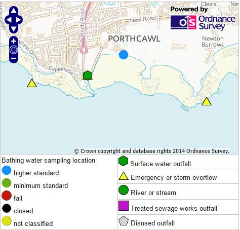
4 Surfers Against Sewage recommendation to review the sampling point at Sandy Bay, Porthcawl Background Sandy Beach is a long, gently sloping, sandy beach with a small harbour at the western end backed by sand dunes to the east and a promenade and Coney Island Amusement Park to the west. The amusement park with kiosks, cafes, restaurants, bars, pubs, fish and chip shops, parking and toilets is located just behind the beach with more facilities available in the town. Swimming, bathing and surfing are all carried out here. With relatively consistent surf, sheltered beach break peaks can be found here offshore in NNW winds, preferred swell direction is WSW. There are several sewer overflows on either side of Sandy Bay with three to the east at Trecco Bay and more to the west. Reasons for proposed change Sandy Beach, Porthcawl is a long, popular beach backed by a promenade and amusement park. A CSO discharges to the sea at the western end of the beach which is approximately 300m from the sampling point, located at the centre of the beach. Due to the popularity of the beach and the proximity of Porthcawl and the seaside infrastructure that accompanies it the entire beach is used for bathing with the car park also located at the western side, close to the CSO. 4
5 5

6 Car parks, amusement park, restaurants, cafes, beach access etc The sampling point several hundred metres from the CSO The CSO discharges at the western end of the bay Recommendation The proposed sampling point is at a point close to the main car park and beach access route Based on the information provided above, we would recommend that the sampling point be moved to the western end of the bay to be closer to the main bather area and the CSO. 6
7 Surfers Against Sewage recommendation to review the sampling point at Aberafan Background A 4km stretch of beach located between the Rivers Afan and Neath, Aberafan (or Aberavon) is backed by Port Talbot and just east of Swansea. Aberafan is long, sandy beach popular with surfers with heavy industry and the relevant infrastructure behind. The usual facilities expected of a large town can be found behind the beach with cafes, restaurants, shops, parking and toilets can all be found close to the beach. Swimming, bathing, body boarding, paddle boarding and surfing are all popular here, however beginners should be wary of the breakwater. While there are no sewer overflows discharging directly onto the beach here there are a large number that discharge into the rivers at either end of the beach. Reasons for proposed change Aberafan is a popular beach and, with the large town of Port Talbot behind it, the entire length of it is used by bathers and water users. With many sewer overflows discharging into the rivers at either end of the beach and the sheer size of the beach, Against Sewage would expect multiple bathing water sample spots where bathers are using the sea. This is particularly true at the eastern end which is popular with surfers and water users and is several hundred metres from the sampling point. 7
8 8

9 The River Neath also has a number of sewer overflows discharging into it The current sampling point is some distance from the CSOs Several sewer overflows discharge upstream into the River Afan Recommendation Based on the information provided above, we would recommend that, due to the popularity of this stretch of coastline and the infrastructure behind the beach, the beach be re-designated as a number of bathing waters to best serve bathers/water users. 9
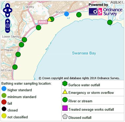
10 Surfers Against Sewage recommendation to review the sampling point at Swansea Bay Background Swansea Bay is a 9km stretch of sand, pebble and mud flats that stretches from Mumbles Head to the River Tawe. It slopes gently and at low tide the waters-edge is a long way from the beach front. Restaurants, cafes, toilets, shops, parking, a University and a slipway are available here with more facilities in the nearby city of Swansea. Sailing, boating, power boating, jet skiing, canoeing, kayaking, swimming, surfing and bathing all take place here. It is also a Watersports Centre of Excellence. Numerous sewer overflows discharge into the sea and waterways here including several that discharge into the River Tawe at the eastern end of the beach. Reasons for proposed change Fronting a relatively built up area, with all the relevant infrastructure, Swansea Bay is a long, popular stretch of beach with numerous river and sewer overflows discharging across its length. There are also a number of main bather areas a significant distance (several kilometres) from the sampling point such as in Mayals to the west and the University, around 1km to the west of the sampling point, close to a CSO and river discharge. 10
11 11

12 Recommended sampling spots are at popular bather areas. Sampling spot CSOs/streams Recommendation Based on the information provided above, we recommend re-designating this bathing water as multiple bathing waters with sampling points at popular bather areas such as the University and in front of the main car park and beach facilities. It is a 9km stretch incorporating different communities, different facilities and different sewer overflows. It is also very popular with bathers and other water users. 12
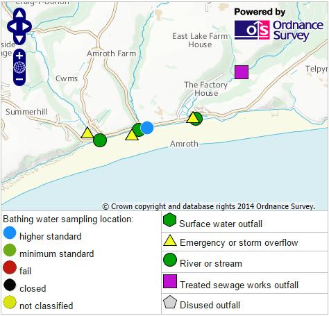
13 Surfers Against Sewage recommendation to review the sampling point at Amroth Central Background Amroth Central is a 4km long sandy beach backed by a pebble bank and promenade. Low rocky cliffs flank the beach while its length is broken up by groynes. Amroth slopes relatively steeply before flattening out into the Bristol Channel. At low tide the shallow waters are some way from the back of the beach. The beach is situated in the Carmarthen Bay Special Area of Conservation and lies within Pembrokeshire Coast National Park. Facilities here include a couple of shops, a restaurant and café, parking and toilets. The beach is popular for swimming, jet skiing, windsurfing and fishing while three sewer outfalls and streams discharge across its length. Reasons for proposed change The sampling point for Amroth Central is located in the centre of the beach close to a CSO and river, however it is flanked by other sewer overflows. Approximately 400m to the west can be found a car park, shops, cafés restaurants and watersports hire, all located close to sewer overflow and stream discharge. The infrastructure and facilities around this area make it clear that it is a popular bather area as does the bus stop and beach information sign. 13
14 14

15 The sampling point is some way away from the main bather area Recommended sampling site at the most popular bather area CSOs and river mouths flank the sampling point. Recommendation Based on the information provided above, we would recommend that the sampling point be moved to the western end of the beach where the main infrastructure and bather area appears to be. 15
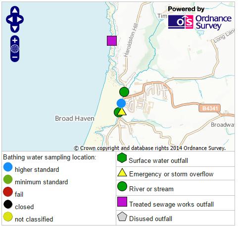
16 Surfers Against Sewage recommendation to review the sampling point at Broad Haven Central Background Next to Little Haven and joined at low tide, Broadhaven sits at the southern end of St Brides Bay and is a long sandy beach backed by high cliffs and the rural town of Broad Haven. The beach is also a Site of Special Scientific Interest part of the Pembrokeshire Marine Special Area of Conservation and lies within Pembrokeshire Coast National Park making it popular with nature lovers. Facilities are fairly limited with parking, toilets, shops, a café, windsurfing hire and a youth hostel. Swimming, bathing, sailing, kayaking, canoeing, kitesurfing, windsurfing, fishing and surfing all occur here. A sewer overflow discharges into a small stream in the centre of the beach while other discharges in the area may affect bathing water quality at Broadhaven Central. Reasons for proposed change While the sampling point is located in the middle of the beach, a river discharges some 250m to the north in front of a large car park, a beach access route and a lifeguard hut indicating that this is a main bather area. There is also a sewer overflow and another river several hundred metres to the south, again with a beach access route and car park. 16
17 17

18 A river discharged across the beach close to a beach access route, lifeguard hut and car park. The recommended sampling point is much closer to the main bather area and beach infrastructure, with a large car park above it. The sampling point is located 250m to the south of a river and main bather area. Another sewer overflow discharges into a river at the southern end of the bathing water. Recommendation Based on the information provided above, we would recommend that either the beach be divided into two with separate sampling points at either end of the beach to correspond with the infrastructure at each location or that the sampling point be moved to the northern end of the beach where it would appear the main bather area is. 18
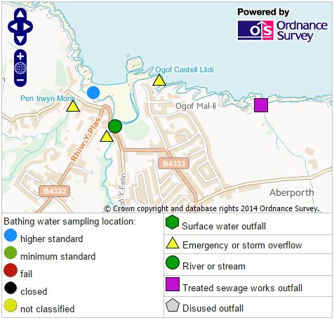
19 Surfers Against Sewage recommendation to review the sampling point at Aberporth Background Aberporth is a picturesque village overlooking a small, sandy beach that slopes gently to the sea. The beach is divided in two by a small headland creating two beaches as the tide pushes in. Rock pools are exposed at low tide, while the cliffs are popular with walkers. The waters surrounding the area are designated as the Cardigan Bay Special Area of Conservation. Plenty of facilities can be found in the village with toilets, shops, cafes, restaurants and parking available. Swimming, sailing, fishing, rock pooling, windsurfing and, occasionally surfing are all popular past times here. There are two small streams, one onto each beach into which numerous sewer overflows discharge. Another sewer overflow discharges across the headland to the east of the bay. Reasons for proposed change With separate beaches at high tide, separate beach access routes, separate car parks and separate sewer overflows it follows naturally that there will be separate bathing areas. This will be particularly true as the tide pushes which makes a very strong case for redesignating Aberporth as two bathing waters. The current sampling point is located in the centre of the western beach several hundred metres from the bather area and sewer overflow at the eastern beach. 19
20 20

21 Another sewer overflow can be found just around the headland. The recommended move is to re-designate the beach as two bathing waters. The sampling point is located on the western beach Recommendation CSOs and streams surround the sampling point Based on the information provided above, we would recommend that the beach be redesignated as two separate bathing waters; East Beach and West Beach based on the separate facilities, sewer overflows and bather areas. 21
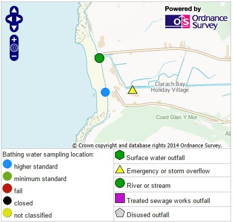
22 Surfers Against Sewage recommendation to review the sampling point at Clarach South Background Clarach South is a popular sand and shingle beach backed by two large holiday parks and divided by the River Clarach. Located in Cardigan Bay, Clarach is flanked by tall cliffs. Coastal walks are popular here with a nature trail linking it to Aberystwyth. Facilities are plentiful here with the holiday parks and restaurants, cafes, take-away, toilets, parking and shops can all be found here. Swimming, sailing, canoeing, kayaking, bathing, windsurfing and surfing are all common place here. A number of sewer overflows discharge upstream of the Afon Clarach which runs across the centre of the beach before meeting the sea. Reasons for proposed change Clarach is a long stretch of beach with two separate parts there are car parks, beach access routes, holiday parks and bather areas at the southern end and the northern end divided by the river into which a number of sewer overflows discharge upstream. 22
23 23

24 With the separate beach access and holiday park, the recommendation is to re-designate this beach as two bathing waters. The Afon Clarach has a number of sewer overflows discharging into is upstream The present sampling point is towards the south of the beach, around 300m to the south of the river and sewer overflow. 24
25 Recommendation Based on the information provided above, we would recommend that the bathing water be re-designated as two separate bathing waters; North and South beach divided by the river. This is due to the infrastructure (car parks, toilets, holiday parks etc) at either end of the beach indicating that there are two separate bather areas. 25
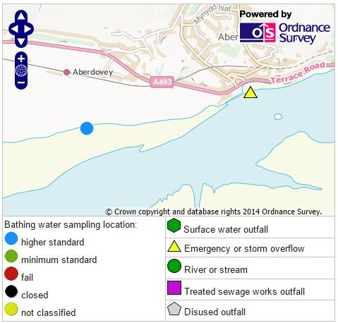
26 Surfers Against Sewage recommendation to review the sampling point at Aberdyfi Background A steep, shelving beach at the mouth of the River Dyfi (Dovey), Aberdyfi is a sandy beach with a harbour at its eastern end located within Snowdonia National Park. The coastal waters have a list of designations in place; a RAMSAR site, Dyfi Estuary Special Protection Area, Llyn Peninsular and Sarnau Special Areas of Conservation and Dyfi Site of Special Scientific Interest. Toilets, cafes, restaurants, a pier, a promenade, parking and a slipway are all available here. A popular destination for sailing (numerous regattas are held here), boating, power boating, windsurfing, kayaking and canoeing, swimming and bathing. A sewer overflow in the centre of the town discharges into the River Dyfi. Reasons for proposed change The majority of the facilities large car park, tourist information centre, toilets, cafes, shops, small harbour, watersports clubs, the village of Aberdovey are all located at the eastern end of the beach several hundred metres downstream of a sewer overflow. Google maps supports our proposal, clearly showing the vast majority of bathers at the area closest to the car park and beach facilities (see below). The sampling spot is currently located approximately 600m to the west of this bathing spot. 26
27 27

28 Two CSOs discharge further upstream into this river which flows across the beach directly in front of a popular watersports spot. The sampling point, around 600m to the west of the main bather area The recommended sampling point is in the, by far, more popular bather area Recommendation Based on the information provided above, we would recommend that the sampling point be moved at least 500m to the east to bring it much closer to the main bather area and provide a more accurate sampling point, protecting the public from sewer overflows. 28
29 Surfers Against Sewage recommendation to review the sampling point at Colwyn Bay Background Located on the North Wales coast, Colwyn Bay is a long sandy beach set within a much larger bay. It is a popular Victorian seaside resort backed by a promenade and seafront walk and broken up by groynes along its length. Facilities are plentiful here with the resort close behind the beach. Shops, restaurants, cafes, pubs, hotels, nightclubs, bars, a harbour, leisure centre, arcades, toilets and parking can all be found here. Windsurfing, swimming, bathing, canoeing, kayaking, jet skiing and fishing are all activities that are commonly carried out here. A number of sewer overflows discharge along the length of the bathing water. Reasons for proposed change Due to the length of this bathing water, the number of sewer overflows that discharge along it and the infrastructure and facilities behind it is clear that there are a number of popular bather areas not correctly represented by the sampling point at the western extent of the beach. Pleasure Pier is also some distance from the sampling point and is a focal point for beach goers. 29
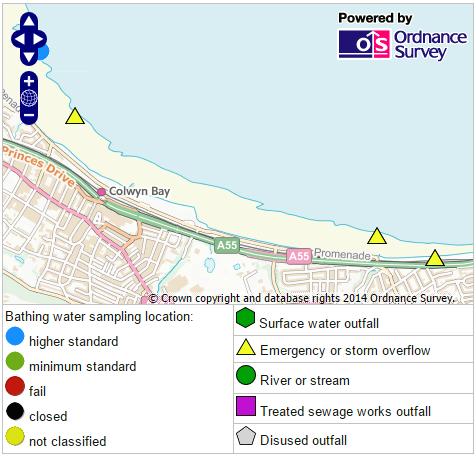
30 30

31 Due to the length of the beach, the sampling point is quite a distance from popular bather areas and sewer overflows The recommended sampling point is closer to Pleasure Pier, another popular bathing spot. A number of sewer overflows discharge along the length of this bathing water. Recommendation Based on the information provided above, we would recommend that, due to the sheer size of the beach it be re-designated as several bathing waters with another sampling point close to Pleasure Pier in the middle of the beach. 31
32 Surfers Against Sewage recommendation to review the sampling point at Rhyl and Rhyl East Background A large, sandy, popular seaside resort, Rhyl has a large tidal range and slopes gently from the promenade to the low tide mark. Numerous cafes, shops, restaurants, kiosks, hotels and bars can be found along the promenade and in the town while toilets, parking, and deck chair hire are present at the beach. Sailing, jet skiing, wakeboarding, canoeing, kayaking, power boating, windsurfing, swimming and bathing are all common watersports here. Two sewer overflows discharge onto Rhyl beach, one to the east and one to the west into the Clwyd River. Rhyl East is essentially the same beach with the sampling points almost on the same transect. Reasons for proposed change Rhyl and Rhyl East are the same beach with the sampling points almost on the same transect (see images below). They are flanked by sewer overflows and, with the infrastructure and facilities behind the beach, it is clear that there are multiple bather areas. There is a large car park, cafes, shops, arcades and an amusement park at the western end of the town close to the mouth of the River Clwyd into which a number of sewer overflows discharge. A golf club and holiday park can be found at the eastern end of the beach also with their own facilities. 32

33 Rhyl Bathing Water: 33

34 Rhyl East Bathing Water 34

35 The two sampling points are in very close proximity. A number of CSOs discharge on either side of the sampling points. Recommendation The recommended outcome is that Rhyl is moved west and Rhyl east is moved further east. Based on the information provided above, we would recommend that both sampling points be moved to better represent the main bather areas of each bathing water. The sampling point for Rhyl should be moved further west, closer to the mouth of the river and to the main bathing area indicated by infrastructure and facilities backing the beach. We recommend that Rhyl East sampling point be moved further east, to the bather area indicated by the golf club and holiday camp and to ensure any impacts from the sewer overflow are accounted for. 35
36 References Environment Agency, 2014., Bathing Water Date Explorer [online] available at < Google, 2014 Maps [online] available at < 36
WELCOME TO SANDOWN BEACH
 WELCOME TO SANDOWN BEACH Sandown is a recognized award winning beach, very popular for its long sandy beach with safe bathing and a wealth of activities. The local amenities and nearby town makes it a
A full version of this guide is available with photos online at
 Llyn.info Beach Guide Printable version to take with you the use of any information on Llyn.info is at the risk of the user and Llyn.info, it s webmaster nor any of it s advertisers can be held responsible
Port Stephens Council
 Port Stephens ouncil State of the eaches 22 23 Overall results Percentage of sites graded as Good or Good: 9 Nine of the eleven swimming sites were graded as Good or Good in 22 23, a fall in performance
Thank you for signing up to the 30 Bays in 30 Days Challenge!
 Introduction Thank you for signing up to the 30 Bays in 30 Days Challenge! The challenge takes place in July when everyone is invited to swim in 30 bays throughout the month. It s a fantastic way to explore
WELCOME TO RYDE. Access Statement for Ryde, Isle of Wight
 WELCOME TO RYDE Ryde Beach is situated to the north of Ryde Town Centre and is accessible either by foot, car or public transport. This is one of the most popular resorts for day trippers, holiday makers
NORTH HAVEN NORTH HAVEN SLSC
 NORTH HAVEN NORTH HAVEN SLSC Patrols: November to March, weekends and public holidays North Haven beach is the product of a major redevelopment of the northern part of the Adelaide coast. In the 1980s,
Thank you for signing up to the 30 Bays in 30 Days Challenge!
 Introduction Thank you for signing up to the 30 Bays in 30 Days Challenge! The challenge takes place in July when everyone is invited to swim in 30 bays throughout the month. It s a fantastic way to explore
Cymyran Strait and Rhoscolyn
 Borthwen and Rhoscolyn Beacon - Photo: www.pixaerial.com 7 No. 7 Grade B 18km OS Sheet 114 Tidal Port Liverpool Start Four Mile Bridge (280783) Finish Porth Dafarch (233800) HW/LW are around 1 hour 30
Bathing Water Profile - Carne (2017)
") Bathing Water Profile - Carne (2017) Bathing Water: Bathing Water Code: Local Authority: River Basin District: Monitoring Point: Carne IESEBWC050_0000_0300 Wexford County Council South Eastern 312952E,
Bathing Water Profile - Carne (2017) Bathing Water: Bathing Water Code: Local Authority: River Basin District: Monitoring Point: Carne IESEBWC050_0000_0300 Wexford County Council South Eastern 312952E,
Welcome to Scotland's Marine Tourism and Recreation Survey
 Welcome to Scotland's Marine Tourism and Recreation Survey The way Scotland's seas and coasts are managed is changing. Marine Scotland, the Scottish Government body with responsibility for managing Scotland's
St Brides Bay coastal waters east
 No: 21 Seascape Character Area Name: St Brides Bay coastal waters east Looking south from Newgale Nolton Haven 21-1 View from Little Haven across St Bride s Bay Summary Description View across Broad Haven
Redondo Beach Boat Launch Ramp Facility
 Redondo Beach Boat Launch Ramp Facility Feasibility Report for the California Department of Boating and Waterways 2015 Grant Cycle For the City of Redondo Beach Submitted by March 13, 2014 Table of Contents
Coastal Processes Day Criccieth
 Coastal Processes Rivers (Conwy) Rivers (Peris) Urban Studies Lowland Glaciation Tourism and National Parks Soils Sand Dunes Upland Glaciation Rural Settlements The Centre and Staff Fieldwork Equipment
TEST 1. PAPER 1 Reading and Writing (1 hour 30 minutes) Reading PART 1
 Reading PART 1") TEST 1 PAPER 1 Reading and Writing (1 hour 30 minutes) Reading PART 1 TIP Read the notices and messages first. Don t look at the A/B/C choices until you understand the texts. Look at each notice or message
TEST 1 PAPER 1 Reading and Writing (1 hour 30 minutes) Reading PART 1 TIP Read the notices and messages first. Don t look at the A/B/C choices until you understand the texts. Look at each notice or message
Eight Hour Coastal Tour
 Eight Hour Coastal Tour To start this coastal tour, you will be picked up at the Sea Terminal and driven north along Douglas Promenade, around Onchan Head and along the coast road to Groudle Glen. Groundle
Wild Coast Adventure Trail, South Africa
 Wild Coast Adventure Trail, South Africa Itinerary Discover the rugged and unspoilt natural beauty of the Wild Coast. Explore rocky headlands, rolling hills and vast tracks of superb golden beaches. This
Bathing Water Profile - Golden Strand, Achill Island (2013)
") Bathing Water Profile - Golden Strand, Achill Island (2013) Bathing Water: Golden Strand, Achill Island Bathing Water Code: IEWEBWC360_0000_0300 Local Authority: Mayo County Council River Basin District:
Bathing Water Profile - Golden Strand, Achill Island (2013) Bathing Water: Golden Strand, Achill Island Bathing Water Code: IEWEBWC360_0000_0300 Local Authority: Mayo County Council River Basin District:
Environmental Protection on the Gold Coast of Queensland, Australia. 1. What is the appeal of the Gold Coast to tourists?
 Environmental Protection on the Gold Coast of Queensland, Australia Sections 1. What is the appeal of the Gold Coast to tourists? 2. How are Gold Coast visitor trends changing? 3. How can the impacts of
Proportion (%) of Total UK Adult Population (16+)s. Participating in any Watersports Activity
 of Total UK Adult Population (16+)s. Participating in any Watersports Activity") Proportion (%) of Total UK Adult Population (16+)s Participating in any Watersports Activity Headlines Participation in any activities up 2.1% point 14.3m UK adults participating Highest volume recorded
Proportion (%) of Total UK Adult Population (16+)s Participating in any Watersports Activity Headlines Participation in any activities up 2.1% point 14.3m UK adults participating Highest volume recorded
Recreational Uses of St Marys Bay and Masefield Beach Panuku Development Auckland
 Appendix D Recreational Uses of St Marys Bay and Masefield Beach Panuku Development Auckland Beca // 2 May 2018 4216571 // NZ1-15242655-52 0.52 // page 133 Recreational uses of St Marys Bay and Masefield
Tenby and Caldey Island
 No: 39 Seascape Character Area Name: Tenby and Caldey Island Tenby with spire from the south Tenby North Beach with harbour Tenby- sailing dinghy activity off North Beach View across to Caldey island from
Risk Assessment. Compiled by: Lawrence Smith Date Compiled: 1 February 2009
 Risk Assessment Compiled by: Lawrence Smith Date Compiled: 1 February 2009 Location: Gwithian Date of Activity: Ongoing Activity: Kitesurfing on the sea and launching and landing of LEI kites on land.
Balmoral Beach to The Spit
 Balmoral Beach to The Spit 2 hrs 30 mins.3 km One way Hard track 85m This walks follows the coast from Balmoral to the Spit and across Spit Bridge. There are some alternate tracks to consider at high-tides,
Upstreampaddle 25.South arm of the Brunswick River, Simpson s Creek drains the freshwater swamp lands of Tyagarah Nature Reserve, 750 hectares. Furthe
 Upstreampaddle 24 The Brunswick River is a shorter length river on the coastal plain of Northern New South Wales. The areas of interest to canoeists are: the reach from the town of Mullumbimby down to
Marine Operations Manual Section 08. Leisure Zone Management Policy
 Marine Operations Manual Section 08 Leisure Zone Management Policy Document Author: Nick Shearman Contact Details Telephone: 01304 240400 Ext. 4522 E-Mail: Nick.Shearman@doverport.co.uk Document Owner
Nearest Town: Teignmouth Start: From Teignmouth Beach with Car Parking Public car. Finish: Newton Abbot Town Quay Postcode TQ12 4AD - SX
 Teign Estuary Teignmouth Devon Challenging Trail: Please be aware that the grading of this trail was set according to normal water levels and conditions. Weather and water level/conditions can change the
Wallarah Coastal Walk
 Wallarah Coastal Walk 3 hrs 8.3 km Return Hard track 247m This walk starts at Caves Beach and travels south along the coastline, until reaching the Pinney s Headland Lookout. There are many opportunities
3 Star Sea Training Notes
 3 Star Sea Training Notes Technical Syllabus Part A Personal Paddling Skills A.1 Lifting, carrying, launching and landing Training should aim to develop good, safe lifting and carrying techniques appropriate
3 Maps and Charts In order to navigate we need to use some form of map. The two choices are nautical charts, or land maps.
 13 3 Maps and Charts In order to navigate we need to use some form of map. The two choices are nautical charts, or land maps. Charts Nautical Charts only show the land detail that is visible from the sea.
Who are your potential customers?
 Beachclubs Who are your potential customers? Not necessarily Action Junkies. People that like to dip in and out of activities when they feel like it i.e. do more than sit by the pool. Want to improve on
LOFOTEN ISLAND KAYAK TOUR by JAMES BAXTER
 LOFOTEN ISLAND KAYAK TOUR by JAMES BAXTER This is a short account of a 9 day kayak trip round the Lofoten Islands off the west coast of Northern Norway and just above the Arctic Circle. They form a 150
DOWNLOAD OR READ : SURFING NEWPORT BEACH PDF EBOOK EPUB MOBI
 DOWNLOAD OR READ : SURFING NEWPORT BEACH PDF EBOOK EPUB MOBI Page 1 Page 2 surfing newport beach surfing newport beach pdf surfing newport beach The Upper Bay of Newport is a canyon, which was carved by
English Blue Flags not meeting the criteria: Region Responsible Council County Beach. SW Cornwall Cornwall Polzeath. SW Cornwall Cornwall Gyllyngvase
 SAS Call For 35 Blue Flags to Be Withdrawn From Beaches Around The UK Clean water campaigners Surfers Against Sewage (SAS) are calling for 35 British beaches to be stripped of their Blue Flag status. SAS
Bouddi Coastal Walk. 5 hrs. Hard track 8.1 km One way. 364m
 Bouddi Coastal Walk 5 hrs Hard track 8.1 km One way 4 364m This is one of the longer walks in the Bouddi National Park and it is rich in scenery. The walk follows the coastline with many side trips to
coastal Safety challenge Leaders notes
 coastal Safety challenge Leaders notes Leaders notes COASTAL SAFETY CHALLENGE INTRODUCTION The Scout Association is pleased to be working with The Maritime and Coastguard Agency (MCA) to bring you the
Wattamolla to Big Marley Beach
 Wattamolla to Big Marley Beach 4 hrs 10.4 km Circuit Moderate track 4m This walk is an excellent loop which takes in both the coast and the heathy inland of Royal National Park. Nearly the whole walk has
OECS Regional Engineering Workshop September 29 October 3, 2014
 B E A C H E S. M A R I N A S. D E S I G N. C O N S T R U C T I O N. OECS Regional Engineering Workshop September 29 October 3, 2014 Coastal Erosion and Sea Defense: Introduction to Coastal Dynamics David
Pro Kitesurfing School & Kite Surf Café
 Pro Kitesurfing School & Kite Surf Café Bringing a new exciting Olympic Pro Kitesurfing Village and lifestyle sports into the heart of Rhyl. Our incredible flagship facility delivers some of the UK s best
4 th Quarter 2014 Report OC MPA Watch Program Orange County Coastkeeper
 4 th Quarter 2014 Report OC MPA Watch Program Orange County Coastkeeper Intro January 1 st, 2012 was the implementation date for the South Coast MPAs from Point Conception to the Mexican border. The Orange
SANDBANKS COAST PROTECTION
 SANDBANKS COAST PROTECTION David Robson, Senior Engineer, Coastal & Drainage Team Borough of Poole Leisure Services (T) 01202 265265 (E) d.robson@poole.gov.uk May 2003 SANDBANKS COAST PROTECTION Introduction
Campbell Drive to Snapper Point
 Campbell Drive to Snapper Point 1 hr 45 mins 4.2 km One way Experienced only 135m This walk follows the Coast Track to Frazer Beach, along the Geebung and (overgrown) Grass Tree Tracks. From the northern
April 7, Prepared for: The Caribbean Disaster Emergency Response Agency Prepared by: CEAC Solutions Co. Ltd.
 April 7, 2006 Prepared for: The Caribbean Disaster Emergency Response Agency Prepared by: Introduction CEAC Solutions Co. Ltd was commissioned in May 2005 to prepare coastal beach erosion hazard maps for
Spit Bridge to Middle Head Forts
 Spit Bridge to Middle Head Forts 2 hrs 30 mins 6.3 km One way Hard track 4 181m This scenic walk takes you from the Spit Bridge, along the coast to explore the Middle Head Forts. There are a few alternate
Studland Bay Context and Learning Aims
 Studland Bay Enquiry 7: How are coastal processes affecting Studland Bay? Context and Learning Aims Pupils will be supported in and outside of the classroom to: Identify; describe and explain the physical
San Diego-Scripps Coastal SMCA and Matlahuayl SMR Survey Sites -La Jolla-
 San Diego-Scripps Coastal SMCA and Matlahuayl SMR Survey Sites -La Jolla- BACKGROUND INFORMATION The La Jolla transects cover two marine protected areas. The area north of the Scripps Pier is the limited-take
Lake Nillahcootie. Recreation Guide
 Lake Nillahcootie Recreation Guide Welcome to Lake Nillahcootie Discover prime fishing, boating and recreation opportunities at Lake Nillahcootie. Lake Nillahcootie is located on the Broken River in north-eastern
VISITING BOATS INFORMATION
 VISITING BOATS INFORMATION 2017 Seaham Harbour Marina is a joint venture between the Victoria Group and Durham County Council Marina Management Unit 10, The Waterside Seaham Harbour Marina, Seaham County
Beach profile surveys and morphological change, Otago Harbour entrance to Karitane May 2014 to June 2015
 Beach profile surveys and morphological change, Otago Harbour entrance to Karitane May 2014 to June 2015 Prepared for Port Otago Ltd Martin Single September 2015 Shore Processes and Management Ltd Contact
Business for Sale BRIBIE ISLAND. Live the life you ve always dreamed about!
 Business for Sale BRIBIE ISLAND Live the life you ve always dreamed about! Enjoy fishing, snorkeling, swimming, surfing, kayaking, windsurfing, sailing surf beaches, quiet bays and lots of wildlife. Only
Exe Estuary Management Partnership. Including sections taken from Minutes supplied by Exeter Port User Group
 Zonation and Code of Conduct Review Minutes 10:00-13:00 Thursday 9 th March 2017 Location: Exe Sailing Club, Tornado, Shelly Rd, Exmouth EX8 1EG Including sections taken from Minutes supplied by Exeter
WELCOME TO THE ACTIVITY WALES EVENTS RACE GUIDE
 RACE GUIDE 2016 ACTIVITYWALESEVENTS.COM WELCOME TO THE ACTIVITY WALES EVENTS RACE GUIDE Here is a guide to our 2016 races. We have something that suits every ability; from a 5k to a 26.2 mile marathon,
Delaware Chapter Surfrider Foundation - Indian River Inlet Monitoring
 Delaware Chapter Surfrider Foundation - Indian River Inlet Monitoring In 2012, the Delaware Surfrider Foundation Chapter formed the Surf Quality and Access Committee to focus on issues such as surf spot
International Learn To Swim Programme Water Safety Questions
 International Learn To Swim Programme Water Safety s s for First Step Series s Poolside Safety & Poolside Rules 1. Where is the shallow end of the The answer is specific to the centre. swimming 2. When
Coast Survey Stretch 03 Seaview High Street to Sandown Zoo
 Coast Survey Stretch 03 Seaview High Street to Sandown Zoo Overview map of the stretch Introduction The route starts at the attractive village of Seaview, through the wooded Priory Bay, passing the remains
For information on the beaches in the area please look at our beaches page.
 Photographic Holiday St Merryn The parish and village of St Merryn, of 3,798 acres, includes more than 5 1/2 miles of coastline, with some of the most dramatic cliffs and beautiful beaches in Cornwall.
Visiting Lake Macquarie
 Visiting Lake Macquarie Lake Macquarie is the largest coastal salt water lake in Australia and is a prime boating destination for both small and large vessels. Many sailing regattas and fishing activities
Ref: LCAA5899 Guide 565,000. Seathrift, Loe Bar Road, Porthleven, Cornwall
 Guide 565,000 Seathrift, Loe Bar Road, Porthleven, Cornwall FREEHOLD In the market to be sold straightaway and priced to attract immediate interest. A detached 4 bedroomed family house commanding panoramic
FACTSHEET 2018/2019. Valid as from: 01 st Nov 2018 to 31 st Jan 2020 UK: 1 st Feb 2019 to 31 st Jan The Place to C...
 FACTSHEET 2018/2019 Valid as from: 01 st Nov 2018 to 31 st Jan 2020 UK: 1 st Feb 2019 to 31 st Jan 2020 The Place to C... The Place to B HERITAGE C BEACH CLUB The Place to C... the Place to B 2500 HECTARES
Canal Dock Boathouse, Inc. (CDBi) Paddle-Sports Request for Proposal Q & A Posted to CDBi website 9/16/2017
 Paddle-Sports Request for Proposal Q & A Posted to CDBi website 9/16/2017") Canal Dock Boathouse, Inc. (CDBi) Paddle-Sports Request for Proposal Q & A Posted to CDBi website 9/16/2017 *(All responses below are subject to further scrutiny by the City of New Haven and could be updated
Canal Dock Boathouse, Inc. (CDBi) Paddle-Sports Request for Proposal Q & A Posted to CDBi website 9/16/2017 *(All responses below are subject to further scrutiny by the City of New Haven and could be updated
Cycling Tourism Growth Opportunities in Nova Scotia. Rum Runners Trail Team April 18, 2017
 Cycling Tourism Growth Opportunities in Nova Scotia Rum Runners Trail Team April 18, 2017 Cycling Tourism Insights Where did we gather cycling tourism information? 2015 Nova Scotia Visitor Exit Survey.
Ref: LCAA7289 2,000,000. Sea House, 29 Lusty Glaze Road, Porth, Newquay, Cornwall FREEHOLD
 2,000,000 Sea House, 29 Lusty Glaze Road, Porth, Newquay, Cornwall FREEHOLD Located directly above Porth beach. An exceptional, contemporary coastal residence with nearly 7,000sq.ft. of beautifully proportioned
Nikiana beach club introduction
 Seafarer Beach Clubs in Greece enjoy fantastic beach front positions in beautiful surroundings, and adhere to the principle that small is beautiful with each beach club catering for a maximum of 60 or
*Sandy Point State Park Paddling Routes
 *Sandy Point State Park Paddling Routes *Paddleboards are crazy popular in Anne Arundel County creeks and rivers. The life guards on this park s beaches have paddleboards to use in recusing swimmers. Not
COPENHAGEN S NEW CATCH. How Cruise Copenhagen s redevelopment of Langelinie port is catching more than just our attention
 COPENHAGEN S NEW CATCH How Cruise Copenhagen s redevelopment of Langelinie port is catching more than just our attention INTERNATIONAL: LANGELINIE FISHERY Words & pictures: Tess Martin COPENHAGEN S NEW
TITLE: COASTAL EROSION AND LANDFORMS.
 TITLE: COASTAL EROSION AND LANDFORMS. AIM: What are the factors that influence the formation of coastal features along Fishing Pond beach Trinidad? LOCATION OF FIELD STUDY: The study was carried out in
Leisure activities. Leisure Activities
 Leisure Activities Martinhal Beach Resort & Hotel is the natural family friendly escape for those who want the very best in beachside accommodation alongside an almost endless array of sports and activities.
 Cor nwa 1 Press Release April 2018 01208 811152 francesca@visitcornwall.com @VC_B2B llat itsb est 2 COME TO CORNWALL WITH A SPRING IN YOUR STEP NEW for 2018: Visit Cornwall is officially proclaiming Cornwall
Bathing Water Profile - Loughrea Lake (2013)
") Bathing Water Profile - Loughrea Lake (2013) Bathing Water: Loughrea Lake Bathing Water Code: IEWEBWL29_194_0100 Local Authority: Galway County Council River Basin District: Western Monitoring Point: 162397E,
Bathing Water Profile - Loughrea Lake (2013) Bathing Water: Loughrea Lake Bathing Water Code: IEWEBWL29_194_0100 Local Authority: Galway County Council River Basin District: Western Monitoring Point: 162397E,
United Kingdom names three Ramsar sites for World Wetlands Day
 United Kingdom names three Ramsar sites for World Wetlands Day 30 March 2005 Three offshore Ramsar sites in the Channel Islands The United Kingdom's Department of Environment, Food, and Rural Affairs (defra)
PRICE REDUCED! SANDPINES GOLF COURSE & DEVELOPMENT PARCELS FOR SALE SALE PRICE REDUCED! th Street Florence OR PROPERTY SPECS
 PRICE REDUCED! SALE PRICE REDUCED! Total Price: $5,500,000 $4,000,000 Price Per Acre: $26,066 $18,957 PROPERTY SPECS 18-Hole 4 1/2 Star Rees Jones-designed Golf Course 173.42 Acres - 7,190 yard golf course
Environmental Definitions and Deployment Guidance for Instructors, Coaches and Leaders
 Environmental s and Deployment Guidance for Instructors, Coaches and Leaders This document provides guidance and environmental definitions that can be applied when choosing paddlesport activity. British
1.5 Understand how ocean waves and currents change the face of coastal areas. (Chapter 3)
") 1.5 Understand how ocean waves and currents change the face of coastal areas. (Chapter 3) 1. Hydraulic Action/Pressure - air being forced into crack in rocks. 2. Corrosion (Solution) Minerals such as calcium
1.5 Understand how ocean waves and currents change the face of coastal areas. (Chapter 3) 1. Hydraulic Action/Pressure - air being forced into crack in rocks. 2. Corrosion (Solution) Minerals such as calcium
DREEMSKERRY MAENPORTH SOUTH CORNWALL
 DREEMSKERRY MAENPORTH SOUTH CORNWALL DREEMSKERRY TRELAWNEY CLOSE, MAENPORTH, FALMOUTH, CORNWALL, TR11 5HS Prime clifftop position overlooking Falmouth Bay, close to Maenporth Beach Spectacular clifftop
Bathing Water Profile - Rinroe Beach, Carrowtigue (2013)
") Bathing Water Profile - Rinroe Beach, Carrowtigue (2013) Bathing Water: Bathing Water Code: Local Authority: River Basin District: Monitoring Point: Rinroe Beach, Carrowtigue IEWEBWC400_0000_0100 Mayo
Bathing Water Profile - Rinroe Beach, Carrowtigue (2013) Bathing Water: Bathing Water Code: Local Authority: River Basin District: Monitoring Point: Rinroe Beach, Carrowtigue IEWEBWC400_0000_0100 Mayo
Canoe Trip # Length of Trip: 225 kilometres Time Required to Complete Trip: 10 to 14 days Number of Portages: 21 to 25
 Canoe Trip #34 34 Brabant Lake - Wapiskau River - Steephill Lake - Reindeer River - Churchill River - Sandy Bay 225 Kilometers - 10 to 14 days - 21 to 25 portages Length of Trip: 225 kilometres Time Required
Kayak Trip Yeppoon to Stanage Bay (Central Qld coast)
") Kayak Trip Yeppoon to Stanage Bay (Central Qld coast) August 2018. Robin Aurisch. This trip was inspired by a report on the Upstream Paddle site where 5 paddlers did a similar trip back in 2009. To make
Kayak Trip Yeppoon to Stanage Bay (Central Qld coast) August 2018. Robin Aurisch. This trip was inspired by a report on the Upstream Paddle site where 5 paddlers did a similar trip back in 2009. To make
The Albert River - from Lamington National Park down to Moreton Bay
 The Albert River - from Lamington National Park down to Moreton Bay The Lost World the Kerry Road Mt Widgee The right branch of the Albert River rises in Lamington National Park, and runs out of the park
Seashore Wildlife and Tides Education and Learning Pack
 Seashore Wildlife and Tides Education and Learning Pack 0 Key Terms Seashore Wildlife Tides East Beach West Beach Shingle Sand Dunes Marram Grass Site of Special Scientific Interest Maritime and Coastal
The Foreshore Walk. 24m. 1m Lake Macquarie LGA. 1 hr 15 mins 2.9 km One way. Hard track 81m
 The Foreshore Walk 1 hr 15 mins 2.9 km One way Hard track 81m This walk traverses the coastline of the Green Point reserve. By following a variety of tracks and occasionally traveling inland through eucalyptus
National Surfing Reserves
 www.lands.nsw.gov.au National Surfing Reserves From the Minister Tony Kelly MLC Minister for Lands Minister for Rural Affairs Minister for Regional Development The Iemma Government fully supports the National
The Pole House Angarrack Hayle
 The Pole House Angarrack Hayle The Pole House 1 Steamers Meadow, Angarrack, Hayle, TR27 5GY Japanese styled Pole House perfect for exploring the beaches of the north coast and west Cornwall Gwithian -
READING AND LISTENING. A beach. By John Russell
 READING AND LISTENING http://learnenglish.britishcouncil.org/en/magazine/beach A beach By John Russell life jacket water-sport cliff capsize (v.) paradise float (v.) sanctuary refuge anchor (v.) rock pool
Formation and characteristics of different types of beaches
 Activity Title: Formation and characteristics of different types of beaches Focusing questions What different types of beaches are there in New Zealand? How are estuaries different to open coastal sandy
Let s get a move on! Offers Over 375,000
 Let s get a move on! Offers Over 375,000 4 Coastguard Cottages, Elie, KY9 1BJ 4 Coastguard Cottages, Elie, KY9 1BJ Superb opportunity to acquire a most charming traditional terraced property with sea views
The Kent Coast Coastal Access Report
 The Kent Coast Coastal Access Report This document is part of a larger document produced by Kent Area of the Ramblers Association and should not be read or interpreted except as part of that larger document.
Southern Croatia (Dubrovnik)
") Southern Croatia (Dubrovnik) Yacht Charter in Dubrovnik The Republic of Croatia is overlooking the spectacular Adriatic Sea - east of Italy. Slovenia and Hungary lies to the north and Serbia to the northeast,
Southern Croatia (Dubrovnik) Yacht Charter in Dubrovnik The Republic of Croatia is overlooking the spectacular Adriatic Sea - east of Italy. Slovenia and Hungary lies to the north and Serbia to the northeast,
Impacts of breakwaters and training walls
 Across the eastern seaboard of Australia, breakwaters and training walls have instigated fundamental perturbations to coastal and estuary processes. This has induced long-term changes to foreshore alignments,
WALLAROO AND ENVIRONS VENUES FOR 2015 NATIONAL CARNIVAL AND ANGLING CHAMPIONSHIPS
 WALLAROO AND ENVIRONS VENUES FOR 2015 NATIONAL CARNIVAL AND ANGLING CHAMPIONSHIPS Map of AAA 2015 National Angling Championships Area Venue. Note it is 2 hours drive from Adelaide. The following are a
Canoe Trip # Maps: 63L Amisk Lake 63M Pelican Narrows
 Canoe Trip #51 49 Southeast Arem Deschambault Lake - Pelican Narrows - Wunehikun Bay - Attitti Lake - Belcher Lake - Mukoman Lake - Ohoo Lake - Mukoman River - Sokatisewin Lake - Sandy Bay 170 Kilometers
Map 8: Ayrshire Coast: Ardrossan North Bay to Stevenston Pier Map Content Descriptions
 Map 8: Ayrshire Coast: Ardrossan North Bay to Stevenston Pier Map Content Descriptions 1. Built Heritage and Archaeology A total of twenty four sites were recorded in the area covered by Map 8. Of these
HAWKESBURY-NEPEAN RIVER SYSTEM
 HAWKESBURY-NEPEAN RIVER SYSTEM Canoe & Kayak Trail Nepean River / Colo River / Hawkesbury River www.lpma.nsw.gov.au WELCOME Welcome to three canoeing and kayaking opportunities on the Hawkesbury-Nepean
Thanks to Burt Strom, Dick Pearce, and Ed Lombardo, Sr. for their help and information.
 The upper section of the Wood River that runs approximately two miles downstream from the bridge on State Route 165 contains a number of significant pools. Although the river is constantly changing through
PAUL BAGLOLE
 memories made here T here s something special about an island. Prince Edward Island will draw you into its comfortable, relaxed pace. Freed from the stresses of your regular routine, you ll soon find
Risk Assessment. Area / Activity Assessed Kite / Windsurf activity and launching. Location Within Hayle Harbour Limits
 Risk Assessment Location Within Hayle Harbour Limits Area / Activity Assessed Kite / Windsurf activity and launching Assessed by: Haddock CMIOSH 05/04/0 Date Reviewed Steve Townsend 0/0/4 Hazid No Activity
THE FIRST MOUNTAIN BIKE TRAIL CENTRE IN THE GCC & MIDDLE EAST
 THE FIRST MOUNTAIN BIKE TRAIL CENTRE IN THE GCC & MIDDLE EAST INTRODUCTION WELCOME TO HATTA TRAIL CENTRE WEBSITE Hatta Trail Centre is a first MTB Centre in the Middle East, and is a home to multiple cross
Natural Bridges Field Trip Activity
 Natural Bridges Field Trip Activity This is due in class on MONDAY- March 1 - not in sections! Name TA: NOTE ON THE GRADING OF THIS ASSIGNMENT: Many of the questions below (especially in the tidepool part)
Val d Isere Resort Information Getting There
 Val d Isere Resort Information Getting There Val d Isère is justly regarded as one of the best ski Chambery is the closest international airport at just resorts not just in France but in the world. Along
Free Camping Remote Surf Beaches Of The Algarve By Henry Wittcomb READ ONLINE
 Free Camping Remote Surf Beaches Of The Algarve By Henry Wittcomb READ ONLINE If you are searched for a book Free Camping Remote Surf Beaches of the Algarve by Henry Wittcomb in pdf format, then you've
Greystones 1 ST HELENS CLOSE CROYDE
 Greystones 1 ST HELENS CLOSE CROYDE Image not photographed from the property Greystones 1 ST HELENS CLOSE CROYDE A fabulous, light, spacious and airy, 5 bedroom, 5 bathroom family home situated only a
Label the diagram below with long fetch and short fetch:
 Coastal Processes Coasts are shaped by the sea and the action of waves. The processes that take place are erosion, transportation and deposition. The power of waves is one of the most significant forces