GEOLOGY 101 Under the Boardwalk: Coastal Geomorphology
|
|
|
- Frederica Hines
- 6 years ago
- Views:
Transcription
1 GEOLOGY 101 Under the Boardwalk: Coastal Geomorphology What to look for while you're on the beach during spring break. J.S. Kite, WVU What Causes Changes in Sea Level? Answer Varies with Time Scale. Long-Term Changes in Sea Level Shape and Volume of Ocean Basins Varies with Sea-Floor Spreading Rates Slow Spreading = Deeper Ocean Basins Fast Spreading = Shallower Ocean Basins & Seas Spill on to Continents Volume of Glacier Ice ~225 ft Higher if All Glaciers Melt ~400 ft Lower at Pleistocene Maximum


2 Sea Level Variation in Last 700,000 years Long-Term Changes in Sea Level Volume of Glacier Ice Pleistocene Ice Age ft Lower Estuaries = Drowned River Valleys: Delaware Bay, Cheaspeake Bay, Pamlico Sound, Albemarle Sounds Eroded During Glacial Low Sea- Level Stands, Drowned During Interglacial High Sea-Level Stands

 Short Term Changes in Sea Level")
3 Chesapeake Bay Bathymetry Susquehanna Paleo-River Last Century: Ocean Warming & Expansion, Glacial Melting Seismic Sea Waves (Tsunami) Short Term Changes in Sea Level Seismic Sea Waves (Tsunami)

4 Boxing Day Tsunami Animation Tsunami Animation Sites Indonesia Alaska Simulation Tides - Why? Gravity of the Moon and Sun Acting on Ocean Surface 24 Hr 50 Min: 2 Highs, 2 Lows

5 Tides - Why? Spring Tide = Highest High Tide & Lowest Low Tide Neap Tide = Less Tide Range Why is there a high tide on the earth opposite of the moon? Why is there a high tide on the earth opposite of the moon? Think Bolos


6 Bolos Tides Can Be Enhanced or Reduced by the Shape and Size of a Basin Gulf of Maine, Bay of Fundy Mediterranean Sea The Med - Puny Tides Straits of Gibraltar


7 Bay of Fundy- Mongo Tides Gulf of Maine-Bay of Fundy Tide Model Copyright 2005 SMAST/ UMASSD View this on line at u/research_projects/gb/tidal _simulation/gb_tide_curr.gif What is Deadliest Day in U.S. History? San Francisco Quake, 1906 ~ 500 Dead? Hurricane Katrina, ,836 Dead # Johnstown Flood of 1889 ~ 2209 Dead? Pearl Harbor, Dec ~ 2471 Dead # 11 September 2001 ~ 2986 Dead # November 1918 Flu ~ 3000 Every Day Antietam, 17 Sept Dead (23,000 casualties. NPS: ~ 4000 may have died later) Issac s Storm, 1900: ~ 8000 Dead in Galveston, Texas Alone! # From Wikipedia, the free encyclopedia


8 Antietam/Sharpsburg 17 Sep 1862 National Park Service Data Casualties in 3 categories: 1) dead; 2) wounded; and 3) missing or captured. Approximate Numbers Union Confederate Total Killed 2,100 1,550 3,650 Wounded 9,550 7,750 17,300 Missing/Captured 750 1,020 1,770 Total 12,400 10,320 22,720 These are the approximate numbers for September 17th, No one knows the actual number of men who would later die of their wounds or the number of missing who had been killed. If you take a conservative estimate of 20% of the wounded dying of their wounds and 30% of the missing killed, the approximate number of soldiers that died as a result of this battle are 7,640. Storm Surge Wave created by low atmospheric pressure sucking ocean water into center of storm Add pressure map for Hurrican Camille L Powerful Low Pressure System (L) Generates Partial Vacuum that draws water into a large wave (storm surge) 31 October 2000 Upper-Air Weather Map from Environment Canada / d ti /t h id / d l 9 t li d th j t t ht l


9 Isaac s Storm: The 1900 Galveston Hurricane Galveston Hurricane 1900 Storm Surge Map Tipped House, Galveston, 1900
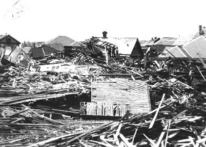
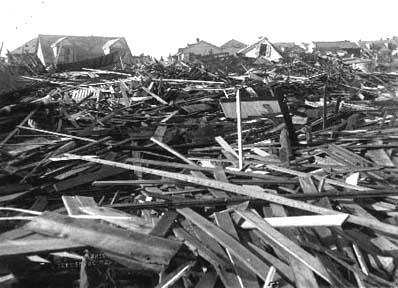
10 Debris at Galveston,1900 Debris at Galveston,1900 Galveston, Texas, 1900


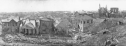
11 Total Destruction at Galveston, Texas, 1900 Lucas Terrace Apartments, BEFORE Galveston Hurricane Lucas Terrace Apartments, AFTER Hurricane
12 Wind Tides Pamlico & Albemarle sounds, NC Westerlies Blow Water Down Estuaries Wind - Creates Most Ocean Waves Wave Height is Controlled by 1. Wind Velocity 2. Fetch = Distance Water Surface is Subjected to Wind Wind Waves


13 Waves = Movement of Motion Wind Waves Swash Swash Surf Surf Wave Wave Base Base Breaking Wave in Shallow Water

14 Swash Beach Terms Surf Breakers Old Berm Berm Wave Erosion-Deposition Wash-Over Refraction Longshore Current Londshore Drift Beach Erosion in the USA


15 Hurricane Fran 1996 See Changes in Next Slide North Carolina Beach before Hurricane Fran, 1996 See Changes from Last Slide Wash-Over Deposits North Carolina Beach after Hurricane Fran, 1996


16 Hurricane Fran Damage from Wash-Over Beach Erosion: Third Cape Hatteras Lighthouse, North Carolina Now Relocated in Fourth Different Site Stopped Here 10 March 2009 Wave Refraction

17 Wave Refraction Longshore Current & Longshore Drift Longshore Current & Longshore Drift LSC


18 LSD Groins Coastal Structures Coastal Structures: Groins, Ocean City, NJ Plummer et al., 2005, 10 th ed., p. 347 Ocean City NJ USGS Air Photo from Terraserver.com See also Matthew 7:26


19 Coastal Structures: New Jersey Jetties Plummer et al., 2005, 10 th ed., p. 347 Spit: South Carolina Barrier Islands Historical Changes in a Virginia Barrier Island


20 Presque Isle, Lake Erie, PA, image courtesy Chris Schaney LSD Baymouth Bar Primary v. Secondary Coasts (Both Examples from California)


21 Primary Shoreline, Pensacola Florida Secondary Shoreline, Northern California Sandy Primary Shoreline: Albemarle Sound, NC Drowned Roanoke River Valley


22 Rocky Shoreline: Nova Scotia Primary, relict from Glaciation Headland Erosion Wave Energy Concentrated on Headlands, Dispersed in Bays Wave-Cut Landforms


23 Wave-Cut Beach, California Idiotic Building Wave-Cut Shoreline, California Oregon Coast Photo by J.S. Kite


24 High-Energy Rocky Shoreline: Headland Hunter's Brook Beach, Acadia National Park Maine AcadiaNet Inc., Producers of The Downeast Guide A Tombolo in California Reefs Fringing Volcano Atoll


25 Eroding Volcanoes with Fringing Reefs Atoll Coastal Landforms Marine Terraces Paleo- Seastack Marine Terrace Wave-Cut Cliff Wave-Cut Bench Active Seastacks
Under the Boardwalk: Coastal Geomorphology
 Under the Boardwalk: Coastal Geomorphology What to look for while you're on the beach during spring break. What Causes Changes in Sea Level? Answer Varies with Time Scale. Long-Term Changes in Sea Level
Coastal Geomorphology
 Orogeny, Epeirogeny,, Climate-Glaciers, Isostasy & Eustacy Favor Glacial Systems, Colluvial Systems, & Clastic Sediments Ice-Age Systems = So Dynamic that Equilibria May Never Be Reached Seaside, Oregon
Chapter 12: Coasts (after a brief review of Tides)
") Chapter 12: Coasts (after a brief review of Tides) 1 Questions from previous classes: What happens when a wave meets a current? wave = people walking current = bus If wave goes with the current, the wave
Chapter 12: Coasts (after a brief review of Tides) 1 Questions from previous classes: What happens when a wave meets a current? wave = people walking current = bus If wave goes with the current, the wave
Overview. Beach Features. Coastal Regions. Other Beach Profile Features. CHAPTER 10 The Coast: Beaches and Shoreline Processes.
 Overview CHAPTER 10 The Coast: Beaches and Shoreline Processes Coastal regions constantly change. The beach is a dominant coastal feature. Wave activity continually modifies the beach and coastal areas.
page - Laboratory Exercise #5 Shoreline Processes
 page - Laboratory Exercise #5 Shoreline Processes Section A Shoreline Processes: Overview of Waves The ocean s surface is influenced by three types of motion (waves, tides and surface currents). Shorelines
Oceans and Coasts. Chapter 18
 Oceans and Coasts Chapter 18 Exploring the oceans The ocean floor Sediments thicken and the age of the seafloor increases from ridge to shore The continental shelf off the northeast United States Constituent
Shore - place where ocean meets land Coast - refers to the larger zone affected by the processes that occur at this boundary.
 Waves, Beaches, and Coasts Shore - place where ocean meets land Coast - refers to the larger zone affected by the processes that occur at this boundary. Waves: energy moving through water The height of
Shorelines Earth - Chapter 20 Stan Hatfield Southwestern Illinois College
 Shorelines Earth - Chapter 20 Stan Hatfield Southwestern Illinois College The Shoreline A Dynamic Interface The shoreline is a dynamic interface (common boundary) among air, land, and the ocean. The shoreline
Lecture Outlines PowerPoint. Chapter 15 Earth Science, 12e Tarbuck/Lutgens
 Lecture Outlines PowerPoint Chapter 15 Earth Science, 12e Tarbuck/Lutgens 2009 Pearson Prentice Hall This work is protected by United States copyright laws and is provided solely for the use of instructors
Earth Science Chapter 16 Section 3 Review
 Name: Class: Date: Earth Science Chapter 16 Section 3 Review Multiple Choice Identify the choice that best completes the statement or answers the question. 1. The movement of water that parallels the shore
Chapter 20 Lecture. Earth: An Introduction to Physical Geology. Eleventh Edition. Shorelines. Tarbuck and Lutgens Pearson Education, Inc.
 Chapter 20 Lecture Earth: An Introduction to Physical Geology Eleventh Edition Shorelines Tarbuck and Lutgens The Shoreline: A Dynamic Interface The Coastal Zone The shoreline is constantly modified by
Essentials of Oceanography Eleventh Edition
 Chapter Chapter 1 10 Clickers Lecture Essentials of Oceanography Eleventh Edition The Coast: Beaches and Shoreline Processes Alan P. Trujillo Harold V. Thurman Chapter Overview Coastal regions have distinct
Ch 9: Waves. Wind waves. Formation of a wind wave
 Ch 9: Waves 1. Features of Waves 2. Deep-water, shallow water and transitional waves 3. Breaking Waves 4. Wind Waves 5. Tsunamis Cf. Fig. 9-2 Waves are created by a disturbance. * wind (wind waves, L=
/50. Physical Geology Shorelines
 Physical Geology Shorelines Multiple Guess: (You know the drill 2 points each) 1. The path of movement of a water particle in a wave at sea is 1. circular 2. horizontal 3. vertical 4. elliptical 5. none
There are many different kinds of beaches which are generally characterized by the dominance of waves, tides, rivers and currents, and in particular
 Fig. 11-11, p. 253 There are many different kinds of beaches which are generally characterized by the dominance of waves, tides, rivers and currents, and in particular differ by the amount of energy, which
Chapter - Oceans and Coasts
 Chapter - Oceans and Coasts Discussion: What do oceans contribute to the environment of Earth? How do Earth s major systems relate to the oceans? Oceans and Coasts Oceans are important - Thermal regulation
Chapter 10 Lecture Outline. The Restless Oceans
 Chapter 10 Lecture Outline The Restless Oceans Focus Question 10.1 How does the Coriolis effect influence ocean currents? The Ocean s Surface Circulation Ocean currents Masses of water that flow from one
4/20/17. #30 - Coastlines - General Principles Coastlines - Overview
 Writing Assignment Due one week from today by 11:59 pm See main class web pages for detailed instructions Essays will be submitted in Illinois Compass (instructions later) Pick one: Earthquakes, tsunamis,
Shorelines Earth Chapter 20 Chapter 20 Shorelines The Shoreline: A Dynamic Interface Cape Cod and Point Reyes Hurricane Sandy
 1 2 3 4 5 6 7 8 9 10 11 12 13 Shorelines Earth Chapter 20 Chapter 20 Shorelines The Shoreline: A Dynamic Interface The interface is the common boundary where different parts of a system interact. The Coastal
Nearshore Sediment Transport What influences the loss of sediment on Beaches? - Waves - Winds - Tidal Currents - River discharge - Runoff
 Tides & Beaches Nearshore Sediment Transport What influences the loss of sediment on Beaches? - Waves - Winds - Tidal Currents - River discharge - Runoff Oceans Ocean Topography Physical Structure of the
COASTAL ENVIRONMENTS. 454 lecture 12
 COASTAL ENVIRONMENTS Repeated movement of sediment & water constructs a beach profile reflecting the balance between average daily or seasonal wave forces and resistance of landmass to wave action Coasts
Deep-water orbital waves
 What happens when waves approach shore? Deep-water orbital waves Fig. 9.16, p. 211 Wave motion is influenced by water depth and shape of the shoreline wave buildup zone surf zone beach Wave base deepwater
OCN 201 Tides. Tsunamis, Tides and other long waves
 OCN 201 Tides Tsunamis, Tides and other long waves Storm surges Caused by winds and low atmospheric pressure associated with large storms Can raise sea surface by up to 25 ft, bottom contours magnify effect
Ocean Waves. Capillary. Gravity. Wind generated. Tides Tsunamis Seiches
 Ocean Waves Capillary Wind generated Gravity Tides Tsunamis Seiches Capillary waves are driven by the surface tension produced by electrically polarized water molecule San Pedro Lighthouse Waves are alternate
Coastal issues: Beaches and Estuaries. Recent Sea Level: Beaches: Baltimore D.C. Patomac R. Chesapeake Bay
 Coastal issues: Beaches and Estuaries Definitions: Coast = broad zone where both marine & terrestrial processes act It includes the beach, lagoons, marshes, bars etc. Coastal processes act to shape the
Environmental Geology Chapter 11 COASTAL PROCESSES and RELATED HAZARDS
 Environmental Geology Chapter 11 COASTAL PROCESSES and RELATED HAZARDS Introduction >50% of world population concentrated in the coastal zones ~75% of U.S. population living in coastal states Coastal hazard
Marginal Marine Environments
 Marginal Marine Environments Delta: discrete shoreline protuberances formed where rivers enter oceans, semi-enclosed seas, lakes or lagoons and supply sediment more rapidly than it can be redistributed
WIND SPEED LENGTH OF TIME WIND BLOWS (Duration) DISTANCE OVER WHICH IT BLOWS (Fetch)
 DISTANCE OVER WHICH IT BLOWS (Fetch)") WAVES Up and down movement of ocean surface Transportation of energy across the water over vast distances If not stopped by anything, waves can travel entire oceans Size and speed depend upon: WIND SPEED
WAVES Up and down movement of ocean surface Transportation of energy across the water over vast distances If not stopped by anything, waves can travel entire oceans Size and speed depend upon: WIND SPEED
Chapter. The Dynamic Ocean
 Chapter The Dynamic Ocean An ocean current is the mass of ocean water that flows from one place to another. 16.1 The Composition of Seawater Surface Circulation Surface Currents Surface currents are movements
Directed Reading. Section: Ocean Currents. a(n). FACTORS THAT AFFECT SURFACE CURRENTS
. FACTORS THAT AFFECT SURFACE CURRENTS") Skills Worksheet Directed Reading Section: Ocean Currents 1. A horizontal movement of water in a well-defined pattern is called a(n). 2. What are two ways that oceanographers identify ocean currents? 3.
Skills Worksheet Directed Reading Section: Ocean Currents 1. A horizontal movement of water in a well-defined pattern is called a(n). 2. What are two ways that oceanographers identify ocean currents? 3.
Coastal Zones. Coastal Zones
 Page 1 of 15 EENS 3050 Tulane University Natural Disasters Prof. Stephen A. Nelson Coastal Zones Coastal Zones A coastal zone is the interface between the land and water. These zones are important because
The Composition of Seawater
 The Composition of Seawater Salinity Salinity is the total amount of solid material dissolved in water. Most of the salt in seawater is sodium chloride, common table salt. Element Percent Element Percent
Imagine that you can see a side view of a wave as it approaches a beach. Describe how the wave changes as the wave approaches the beach.
 Geology 101 Name Reading Guide for Ch. 19: Shores and Coastal Processes (p. 612) Waves, Currents, and Tides (p. 614) Waves and Currents (p. 614) Imagine that you can see a side view of a wave as it approaches
General Coastal Notes + Landforms! 1
 General Coastal Notes + Landforms! 1 Types of Coastlines: Type Description Primary Coast which is essentially in the same condition when sea level stabilized Coastline after the last ice age, younger.
Chapter 22, Section 1 - Ocean Currents. Section Objectives
 Chapter 22, Section 1 - Ocean Currents Section Objectives Intro Surface Currents Factors Affecting Ocean Currents Global Wind Belts (you should draw and label a diagram of the global wind belts) The Coriolis
Label the diagram below with long fetch and short fetch:
 Coastal Processes Coasts are shaped by the sea and the action of waves. The processes that take place are erosion, transportation and deposition. The power of waves is one of the most significant forces
1 Shoreline Erosion and Deposition
 CHAPTER 12 1 Shoreline Erosion and Deposition SECTION Agents of Erosion and Deposition BEFORE YOU READ After you read this section, you should be able to answer these questions: What is a shoreline? How
3/9/2013. Build house on cliff for a view of the ocean - be one with said view Pearson Education, Inc. Shorelines: summary in haiku form
 Introduction to Environmental Geology, 5e Edward A. Keller Shorelines: summary in haiku form Chapter 11 Coastal Processes Lecture Presentation prepared by X. Mara Chen, Salisbury University Build house
Reading Material. Inshore oceanography, Anikouchine and Sternberg The World Ocean, Prentice-Hall
 Reading Material Inshore oceanography, Anikouchine and Sternberg The World Ocean, Prentice-Hall BEACH PROCESSES AND COASTAL ENVIRONMENTS COASTAL FEATURES Cross section Map view Terminology for Coastal
Montessori for Everyone 2013 Types of Coastlines
 Coast The coast is the part of the land that borders the sea. It is subject to constant change, as the result of the waves and deposits carried by water onto the land. Coastline The coastline is where
4/20/17. #31 - Coastal Erosion. Coastal Erosion - Overview
 Writing Assignment Due Monday by 11:59 pm #31 - Coastal Erosion Beach front property! Great View! Buy now at a great price! See main class web pages for detailed instructions Essays will be submitted in
Unit 11 Lesson 2 How Does Ocean Water Move? Copyright Houghton Mifflin Harcourt Publishing Company
 Unit 11 Lesson 2 How Does Ocean Water Move? Catch a Wave A wave is the up-and-down movement of surface water. Catch a Wave Catch a Wave (wave effects) Surface waves are caused by wind pushing against
1.5 How do ocean waves and currents change the face of coastal areas? (Chapter 3)
") 1.5 How do ocean waves and currents change the face of coastal areas? (Chapter 3) 1. Hydraulic Action/Pressure - air being forced into crack in rocks. 2. Corrosion (Solution) Minerals such as calcium carbonate
1.5 How do ocean waves and currents change the face of coastal areas? (Chapter 3) 1. Hydraulic Action/Pressure - air being forced into crack in rocks. 2. Corrosion (Solution) Minerals such as calcium carbonate
NYS Coastal Waters. Water Resources of NYS: THE NATURE of the COASTAL ZONE. NYS Coastal Waters. NYS Coastal Atlas. Coastal Zone Management 10/10/2014
 Water Resources of NYS: THE NATURE of the COASTAL ZONE NYS Coastal Waters NYS is the only state to border the Atlantic Ocean and the Great Lakes (Lakes Erie and Ontario). Great Lakes shoreline: 577 miles
Today: Coastal Issues and Estuaries
 Today: Coastal Issues and Estuaries Coastal issues Human effect on coastlines What is an estuary Why are they so important? Circulation of water in estuary Environmental issues Coastal Issues: Problem
Coastal management has lagged behind the growth in population leading to problems with pollution
 Fifty percent of the population of the industrialized world lives within 100 km of a coast. Coastal management has lagged behind the growth in population leading to problems with pollution and natural
BEACH PROCESSES AND COASTAL ENVIRONMENTS
 BEACH PROCESSES AND COASTAL ENVIRONMENTS COASTAL FEATURES Cross section Map view TOPICS: Terminology Waves Beach Morphology Barriers Coastal Migration Tides Tidal Flats and Marshes Sediment Budgets Human
OCEAN WAVES NAME. I. Introduction
 NAME OCEAN WAVES I. Introduction The physical definition of a wave is a disturbance that transmits energy from one place to another. In the open ocean waves are formed when wis blowing across the water
Name Class Date. Use the terms from the following list to complete the sentences below. Each term may be used only once. Some terms may not be used.
 Assessment Chapter Test B The Movement of Ocean Water USING KEY TERMS Use the terms from the following list to complete the sentences below. Each term may be used only once. Some terms may not be used.
Oceans in Motion: Waves and Tides
 Oceans in Motion: Waves and Tides Waves Waves are among the most familiar features in the ocean. All waves work similarly, so although we are talking about ocean waves here, the same information would
Questions # 4 7 refer to Figure # 2 (page 321, Fig )
") Shoreline Community College OCEANOGRAPHY 101 Fall 2006 Sample Exam # 3 Instructor: Linda Khandro Questions # 1 3 refer to Figure # 1 (page 284, Fig 11.7) 1. At which position is the moon in its new moon
Shoreline Community College OCEANOGRAPHY 101 Fall 2006 Sample Exam # 3 Instructor: Linda Khandro Questions # 1 3 refer to Figure # 1 (page 284, Fig 11.7) 1. At which position is the moon in its new moon
What are Waves? Earthquake. Waving flags. Vocal Cords Vibrate
 Waves Ch. 10 What are Waves? All waves are movement of energy through a medium (air, rock, water) Series of vibrations or undulations in a medium Wave types: ocean, sound, light, seismic Vocal Cords Vibrate
Define the key terms: - Abrasion - Attrition - Hydraulic action - Solution. Y11 Coasts
 Define the key terms: - Abrasion - Attrition - Hydraulic action - Solution Abrasion caused by waves picking up material which is forced against the cliff face wearing it away Attrition where stones and
Chapter 10 Waves. wave energy NOT the water particles moves across the surface of the sea. wave form moves and with it, energy is transmitted
 Capillary Waves, Wind Waves, Chapter 10 Waves Anatomy of a Wave more like a real wave Tsunamis, Internal waves big waves huge waves rogue waves small waves more like a sine wave Wave direction Wave wave
COASTAL SYSTEMS WAVE ENERGY
 WAVE ENERGY The energy of a wave determines its ability to erode and transport material on the coast Wave energy depends on the fetch, the distance the wind has blown the wave Wind strength and wind duration
Controlling Coastal erosion
 Controlling Coastal erosion Coastal Erosion Rates in the U.S. Coastal Erosion and Stabilization Economic pressures demanding the stabilization of beaches and coastlines are immense Coastal Erosion and
15 Coasts and Changing Sea Levels
 CHAPTER 15 Coasts and Changing Sea Levels PEOPLE LIVE ALONG COASTS for a variety of good reasons. Oceans moderate climate, supply fish and other sea resources, provide transportation for people and goods,
Chesil Beach, Dorset UK High energy, shingle coastline. Brighton Beach, Sussex UK Pebble beach
 Beaches: Depositional landform Extends from the highest high tide to the lowest low tide. Very important temporary store in coastal system. Accretion: sediment returning to the visible portion of a beach
New Jersey Coastal Zone Overview. The New Jersey Beach Profile Network (NJBPN) 3 Dimensional Assessments. Quantifying Shoreline Migration
 3 Dimensional Assessments. Quantifying Shoreline Migration") New Jersey Coastal Zone Overview The New Jersey Beach Profile Network (NJBPN) Objectives Profile Locations Data Collection Analyzing NJBPN Data Examples 3 Dimensional Assessments Methodology Examples Quantifying
New Jersey Coastal Zone Overview The New Jersey Beach Profile Network (NJBPN) Objectives Profile Locations Data Collection Analyzing NJBPN Data Examples 3 Dimensional Assessments Methodology Examples Quantifying
LAB: WHERE S THE BEACH
 Name: LAB: WHERE S THE BEACH Introduction When you build a sandcastle on the beach, you don't expect it to last forever. You spread out your towel to sunbathe, but you know you can't stay in the same spot
Soft Designs for a Harsh Climate: Trends in Coastal Engineering
 Alaska Department of Transportation & Public Facilities Ruth Carter, PE, and Harvey Smith, PE Coastal Engineering Section 20 October 2014 Soft Designs for a Harsh Climate: Trends in Coastal Engineering
Coasts. 1. Coastal Processes. 1.1 Coastal erosion. 1.2 Sediment transport. Coastal Processes and Landforms. i. Hydraulic action
 Coasts Coastal Processes and Landforms 1. Coastal Processes 1.1 Coastal erosion i. Hydraulic action When waves strike against a rock surface, the waves trap air in the rock joints. This air is compressed
Ocean Motion Notes. Chapter 13 & 14
 Ocean Motion Notes Chapter 13 & 14 What is a Wave? Wave: movement of energy through a body of water How are Waves Caused? Caused mostly by wind Wind blowing on the water transmits energy to the water Size
Name: Form: 2.To know the difference between Constructive and Destructive wave # $
 Name: Form: Landforms and landscape processes: COASTS 1. To know what factors affect the strength of waves # $ 2.To know the difference between Constructive and Destructive wave # $ 3. To be able to draw
Australian Coastal Councils Conference
 Australian Coastal Councils Conference Kiama March 2019 Where Has My Beach Gone? (and what can I do about it?) Dr Andrew McCowan Water Technology Where Has My Beach Gone? Where Has My Beach Gone? Where
Why Study Shorelines?
 Why Study Shorelines? The seafloor is the largest part of Earth s surface. Many seafloor features and processes provide evidence of plate tectonics. Seafloor sediments and rocks are a source of several
Types of Estuaries and Mixing Patterns. Mrs. Stahl Marine Science Honors
 Types of Estuaries and Mixing Patterns Mrs. Stahl Marine Science Honors Coastal Plain Form between glacial periods, when water from melting glaciers raises the sea level and floods coastal plains and low
Chapter 11 Tides. A tidal bore is formed when a tide arrives to an enclosed river mouth. This is a forced wave that breaks.
 Chapter 11 Tides A tidal bore is formed when a tide arrives to an enclosed river mouth. This is a forced wave that breaks. Tidal range can be very large Tide - rhythmic oscillation of the ocean surface
R E M I N D E R S. v Two required essays are due by April 9, v Extra Credit: Think Geographically Essays from any five of the textbook s
 R E M I N D E R S v Two required essays are due by April 9, 2019. Ø A third may be used for extra credit in place of a Think Geographically essay. ESSAY TOPICS (choose any two): Contributions of a noted
Anatomy of Coastal Regions
 The Coast I. BEACH ANATOMY Anatomy of Coastal Regions Terms for different parts of beaches and coastal regions Are all about ENERGY- ie, where the ocean s energy Mostly through tides and waves, and shape
Waves Part II. non-dispersive (C g =C)
") Waves Part II Previously we discussed Surface Gravity Waves Deep Water Waves Shallow Water Waves C g T 2 C g h dispersive (C g =C/2) Definitions: phase speed C= /T= /k non-dispersive (C g =C) group speed
Waves Part II Previously we discussed Surface Gravity Waves Deep Water Waves Shallow Water Waves C g T 2 C g h dispersive (C g =C/2) Definitions: phase speed C= /T= /k non-dispersive (C g =C) group speed
G. Meadows, H. Purcell and L. Meadows University of Michigan
 www.coj.net/departments/fire+and+rescue/emergency+preparedness/rip+current.htm G. Meadows, H. Purcell and L. Meadows Over 80% of all surf related rescues are attributable to Rip Currents According to the
El Niño Southern Oscillation. Pressure systems over Darwin Australia and Tahiti Oscillate Typically occurs every 4-7 years
 El Niño Southern Oscillation Pressure systems over Darwin Australia and Tahiti Oscillate Typically occurs every 4-7 years 1 2 What is it? Normal Conditions... What is it? During El Niño. 3 Local Effects
MAR 110 LECTURE #15 Wave Hazards
 1 MAR 110 LECTURE #15 Wave Hazards Rogue Wave Hazard Rogue waves are very large open ocean waves of sometimes can range in height from 60 ft (20m) to120 feet (40m) and thus a significant hazard to large
Monterey Peninsula College
 Introduction to Google Earth Name Goals 1. To become proficient at using the basic features of Google Earth. 2. To recognize differences in coastal features between the east and west coast of North America.
UNDERSTANDING STORM SURGE
 The Education Program at the New Jersey Sea Grant Consortium 22 Magruder Road, Fort Hancock, NJ 07732 (732) 872-1300 www.njseagrant.org UNDERSTANDING STORM SURGE ACTIVITY 6 SURGE OF THE STORM http://secoora.org/classroom/virtual_hurricane/surge_of_the_storm>
Coastal Processes and Landforms
 Coastal Processes and Landforms These icons indicate that teacher s notes or useful web addresses are available in the Notes Page. This icon indicates that the slide contains activities created in Flash.
Beach Profiles: Monitoring Sea Level Rise. Student Activity Sheet. Name Date Class
 Beach Profiles: Monitoring Sea Level Rise Student Activity Sheet Name Date Class A shoreline is the area where the water and land meet. This is where we find beach: areas where sediments (sand or other
Longshore sediment transport
 and Orson P. Smith, PE, Ph.D., Professor Emeritus Longshore transport Waves breaking at an angle to shore Sediment under breakers lifted by saltation Drops back to sea bed a little down drift Swash (runup)
The Storm Surge Hazard 2018 TS-8 Tropical Meteorology 2
 The Storm Surge Hazard 2018 TS-8 Tropical Meteorology 2 Daniel Noah National Weather Service Tampa Bay daniel.noah@noaa.gov Tropical Cyclone Storm Surge Is a large dome of water, often 50 to 100 miles
Unit VI Detecting Coastal Change with Lasers. Modern Coastal Studies
 Unit VI Detecting Coastal Change with Lasers On the cutting edge Barrier Islands provide natural protection against the destructive wind, waves, and tides that wash the shores of coastal communities. As
TITLE: COASTAL EROSION AND LANDFORMS.
 TITLE: COASTAL EROSION AND LANDFORMS. AIM: What are the factors that influence the formation of coastal features along Fishing Pond beach Trinidad? LOCATION OF FIELD STUDY: The study was carried out in
1.5 Understand how ocean waves and currents change the face of coastal areas. (Chapter 3)
") 1.5 Understand how ocean waves and currents change the face of coastal areas. (Chapter 3) 1. Hydraulic Action/Pressure - air being forced into crack in rocks. 2. Corrosion (Solution) Minerals such as calcium
1.5 Understand how ocean waves and currents change the face of coastal areas. (Chapter 3) 1. Hydraulic Action/Pressure - air being forced into crack in rocks. 2. Corrosion (Solution) Minerals such as calcium
ALTERNATIVES FOR COASTAL STORM DAMAGE MITIGATION
 ALTERNATIVES FOR COASTAL STORM DAMAGE MITIGATION Dave Basco Old Dominion University, Norfolk, Virginia, USA National Park Service Photo STRUCTURAL (changes to natural, physical system) hardening (seawalls,
Apostle Islands National Seashore
 Apostle Islands National Seashore David Speer & Phillip Larson October 2 nd Fieldtrip Report Table of Contents Introduction 1 Stop 1: Apostle Island Boat Cruise 1 Stop 2: Coastal Geomorphology 5 Stop 3:
SUBJECT: EARTH SCIENCE PAPER: THE DYNAMIC EARTH. Code : 27 COASTAL PROCESSES AND LANDFORMS PROF. A. BALASUBRAMANIAN
 SUBJECT: EARTH SCIENCE PAPER: THE DYNAMIC EARTH Code : 27 TOPIC: COASTAL PROCESSES AND LANDFORMS BY PROF. A. BALASUBRAMANIAN Objectives After attending this module, the user would be able to understand
Swell and Wave Forecasting
 Lecture 24 Part II Swell and Wave Forecasting 29 Swell and Wave Forecasting Motivation Terminology Wave Formation Wave Decay Wave Refraction Shoaling Rouge Waves 30 Motivation In Hawaii, surf is the number
Ch19&21 Test. Multiple Choice Identify the choice that best completes the statement or answers the question.
 Ch19&21 Test Multiple Choice Identify the choice that best completes the statement or answers the question. 1. A large body of saline water that may be surrounded by land is a(n) a. submersible. c. global
SURFACE CURRENTS AND TIDES
 NAME SURFACE CURRENTS AND TIDES I. Origin of surface currents Surface currents arise due to the interaction of the prevailing wis a the ocean surface. Hence the surface wi pattern (Figure 1) plays a key
Introduction to Storm Surge
 Introduction to Storm Surge Hurricane Katrina (2005) Mississippi 1200 deaths, $108 billion damage Hurricane Sandy (2012) Northeast U.S. 73 deaths, $65 billion damage Hurricane Ike (2008) - Bolivar Peninsula,
Coastal Change and Conflict
 Coastal Change and Conflict Outline of the Topic Contrasting Coasts why do all coasts not look the same? Geology of the coast the impact rock structure has on the coastline Waves Constructive and destructive
Exam 2 test bank with page references (Note that at the end of each question is a reference to the page where the answer can be found) Chapter 6 Water
 Chapter 6 Water") Exam 2 test bank with page references (Note that at the end of each question is a reference to the page where the answer can be found) Chapter 6 Water 1. The hydrogen atoms in a water molecule tend to
Exam 2 test bank with page references (Note that at the end of each question is a reference to the page where the answer can be found) Chapter 6 Water 1. The hydrogen atoms in a water molecule tend to
The Dynamic Coast. Right Place Resources. A presentation about the interaction between the dynamic coast and people
 The Dynamic Coast Houses threatened by coastal erosion in California Right Place Resources A presentation about the interaction between the dynamic coast and people For the rest of the presentations in
A Little Math. Wave speed = wave length/wave period C= L/T. Relationship of Wave Length to Depth of Wave Motion
 Ocean Waves 1 2 1 A Little Math Wave speed = wave length/wave period C= L/T 3 Relationship of Wave Length to Depth of Wave Motion 4 2 Motion of Water as Wave Passes Water in the crest of the wave move
OECS Regional Engineering Workshop September 29 October 3, 2014
 B E A C H E S. M A R I N A S. D E S I G N. C O N S T R U C T I O N. OECS Regional Engineering Workshop September 29 October 3, 2014 Coastal Erosion and Sea Defense: Introduction to Coastal Dynamics David
The Sea Geography Notes JC-Learn. JC-Learn. Geography Notes The Sea. 1 P a g e
 JC-Learn Geography Notes The Sea 1 P a g e The Sea *Here, you can choose to study the chapter on glaciation or the one on the sea, or even both, because whenever these topics come up in the Junior Cert
The Movement of Ocean Water. Currents
 The Movement of Ocean Water Currents Ocean Current movement of ocean water that follows a regular pattern influenced by: weather Earth s rotation position of continents Surface current horizontal movement
Beaches Unit (4.5 pts)
") T. James Noyes, El Camino College Beaches Unit (Topic 6A) page 1 Name: Section: Beaches Unit (4.5 pts) Beaches and Shorelines Are Always Changing Waves are slowly and inexorably altering the shoreline,
T. James Noyes, El Camino College Beaches Unit (Topic 6A) page 1 Name: Section: Beaches Unit (4.5 pts) Beaches and Shorelines Are Always Changing Waves are slowly and inexorably altering the shoreline,
Variation in Beach Profile and Sediment Characteristics at Popham Beach, Phippsburg, ME
 Colby College Digital Commons @ Colby Undergraduate Research Symposium Student Research 2006 Variation in Beach Profile and Sediment Characteristics at Popham Beach, Phippsburg, ME Kathryn Lidington Colby
QUIZ SET C: Oceanography 101. Chapter 8
 QUIZ SET C: Oceanography 101 Check the Course Syllabus for the DUE DATE of this quiz set. Come to class on the due date with a SCANTRON filled in with your answers. You must submit a SCANTRON to receive