GROUNDWATER CONDITIONS IN THE COASTAL REGIONS OF THE DRY ZONE OF SRI LANKA. A.P.G.R.L. Perera C.R. Panabokke
|
|
|
- Eugene Randell Potter
- 5 years ago
- Views:
Transcription
1 GROUNDWATER CONDITIONS IN THE COASTAL REGIONS OF THE DRY ZONE OF SRI LANKA A.P.G.R.L. Perera C.R. Panabokke
2 Shallow Karstic Aquifer Deep Confined Aquifer Shallow Aquifers on Coastal Sands Alluvial Aquifer MAJOR AQUIFERS OF SRI LANKA REGOLITH AQUIFER OF SMALL TANK CASCADE REGION OF NCP AND NWP LEGEND Shallow karstic Aquifer Deep Confined Aquifer Shallow Aquifers on Coastal Sands Laterite (Cabook) Aquifer Alluvium Aquifer Metamorphic Hard Rock Aquifer Regolith Aquifer of Hard Hard rock Metamorphic Rock region with Small Tank Cascades Shallow Aquifers on Coastal Sands Laterite Aquifer INTERMEDIATE ZONE WET ZONE DRY ZONE
3 AQUIFERS ASSOCIATED WITH THE COASTAL REGIONS OF THE DRY ZONE 1. Shallow Karstic Aquifer of Jaffna Peninsula 2.Deep Confined Aquifers MAJOR AQUIFERS OF SRI LANKA REGOLITH AQUIFER OF SMALL TANK CASCADE REGION OF NCP AND NWP LEGEND Shallow karstic Aquifer Deep Confined Aquifer Shallow Aquifers on Coastal Sands Laterite (Cabook) Aquifer Alluvium Aquifer Metamorphic Hard Rock Aquifer Regolith Aquifer of Hard Hard rock Metamorphic Rock region with Small Tank Cascades 4. Alluvial Aquifers INTERMEDIATE ZONE 3. Coastal Sand Aquifers WET ZONE DRY ZONE
4 [1]. SHALLOW KARSTIC AQUIFER Confined to Jaffna Peninsula Shallow karstic Aquifer Jaffna
5 GROUNDWATER CONDITIONS IN THE JAFFNA PENINSULA
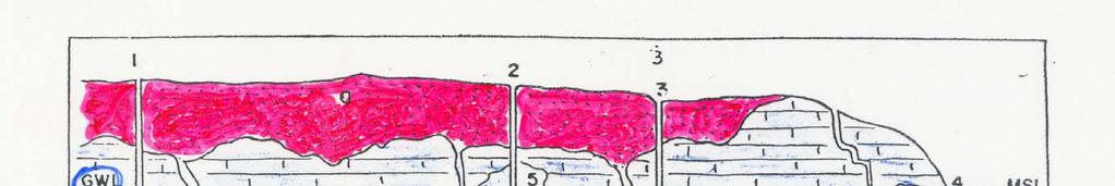
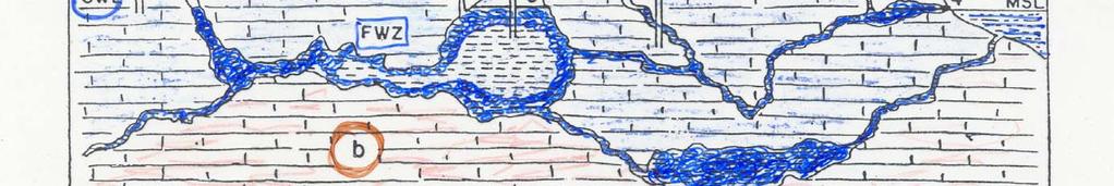
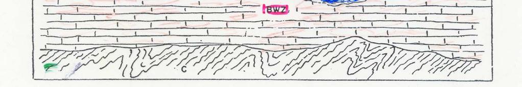
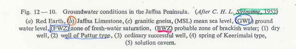
6 GROUNDWATER CONDITIONS IN THE JAFFNA PENINSULA 1 2 a 3 GWL 5 4 MSL FWZ b BWZ c (a)- Red Earth, (b)-jaffna Limestone, (FWZ) Zone of fresh water saturation, (BWZ) Probable zone of brackish water, (1) Dry well, (2) Well of Puttur type, (3) Ordinary successful well, (4) Spring of Keerimalai type, (5) Solution cavern, (MSL) Mean sea level, (GWL) Groundwater level
7 GROUNDWATER MONITORING PROGRAMME In Jaffna Peninsula, well Monitoring programs are being conducted by WRB Results of well monitoring and water sample analysis revealed a high concentration of NO3 in groundwater exceeding maximum permissible level of WHO for drinking water in the western part of the Jaffna Municipal Area. Higher values of EC observed in southern and western part of Jaffna Municipal Area.


8 RESULTS OF WELL MONITORING PROGRAMME Electrical Conductivity May Electrical Conductivity July
9 [2]. DEEP CONFINED AQUIFER Found in the Coastal Regions of North and North-West which extends from Puttalam to Jaffna and towards Mulativu. Sedimentary rocks (miocene limestones /Sandstones) REGOLITH AQUI OF SMALL TANK CASCADE REGION OF NCP AND NWP Deep Confined Aquifer
10 DEEP AQUIFER BASINS Eight distinct deep aquifer basins Average depth of wells m Yield lpm Electrical Conductivity Values moderate to high Vanathavilluwa Basin intensively used for irrigated agriculture Mannar C A Paranthan - Kilinochchi D B MULANKAVIL BASIN MURUNKAN BASIN KONDACHCHI BASIN PARANTHAN BASIN Vavuniya Mulaitivu MULAITIVU BASIN N Palavi & Madurankuliya Basins intensively used for prawn culture farms. Puttalam VANATHAVILLU BASIN Palavi Basin Madurankuliya Basin

11 MURUNKAN AQUIFER A Cross Section along A-B Line B Confined Aquifer
12 C CONCEPTUAL MODEL OF THE VANATHAVILLUWA AQUIFER Cross Section along C-D Line Main Recharge Area D Main Limestone Aquifer Recharge from rain Lagoon Piezometric level Saline tank Sandstone Sedimentary Limestone Metamorphic Hardrock
13 [3]. COASTAL SAND AQUIFERS CO- TERMINUS WITH REGOSOLS OF SOIL MAP Regosols on Recent Beach and Dune Sands - Flat Terrain Regosols on Recent Beach and Dune Sands - Flat Terrain Regosols on Recent Beach and Dune Sands - Flat Terrain
14 SOIL MAP - COASTAL SAND AQUIFER
15 Mannar Island Kondachchi Kalpitiya [3] 3 MAIN TYPES OF COASTAL SAND AQUIFER JAFFNA Poonery MANNAR COASTAL SAND AQUIFERS OF SRI LANKA Mulankavil MULLAITIVU Shallow DRY Aquifres ZONE on Coastal Spits Shallow aquifers on Coastal Beaches Kokkilai Pulmoddai Kuchchaveli Nilaveli TRINCOMALEE LEGEND Shallow aquifers on coastal spits Shallow aquifers on coastal beaches. Moderately deep aquifers on old coastal plain Distributed all over the coastal regions. 3 Types of aquifers a). Shallow Aquifers on Coastal Spits and Bars Eg : Kalpitiya, Pooneryn, Mannar Kalpitiya Peninsular -Spit Chilaw Katunayaka Negombo COLOMBO PUTTALAM Battulu Oya Panadura Moderately Deep Aquifers of Prior beach Plains WET ZONE INTERMEDIATE ZONE Kalkudai BATTICALOA Kalladi Kalmunai Pottuvil b). Shallow Aquifers on Coastal Beaches Eg: Pulmuddai, Nilaveli, Kalkuda, and Low Sand Dunes Eg: Hambantota c). Moderately Deep Aquifers of Prior beach Plains Eg: Katunayake, Chilaw The total extent KALUTARA Bentota Ambalangoda DRY ZONE Yala Palatupanna Kumana Type 1 & Type 2 estimated 140,000 ha GALLE Tangalla Koggala MATARA Dondra HAMBANTOTA Pocket Beaches
16 3.1. SHALLOW AQUIFERS ON COASTAL SPITS Mainly confined to the coastal spits Pooneryn mesopeninsula JAFFNA Coastal spit type sand aquifer is best expressed in the Kalpitiya Peninsula located in west coastal region of SL Mannar Island Mannar Island Poonery MANNAR Mulankavil M A similar formation is found in the Mannar Island and also in Pooneryn meso-peninsula. Also Batticaloa, Kalladi Kalpitiya Peninsula Kondachchi Kalpitiya Kalpitiya Peninsular -Spit DRY ZONE PUTTALAM Battulu Oya
17 3.2. SCHEMATIC SECTION KALPITIYA AQUIFER KALPITIYA Sea Main Land Sea Land Surface FreshWater Sea Sea Lagoon Puttalam Salt Water sand Sand Bounded by the sea on both western and eastern flanks A thin fresh water lens occur in the sand and is present at depths of 1-3 m. EC of this shallow ground water varies us/cm
18 3.2. GEOLOGICAL CROSS SECTION ON KALPITIYA PENINSULA DEPTH (MAMSL) Sea SAND AQUIFER Area under intensive cultivation Wells WATER TABLE Lagoon CLAYS MIOCENE LIMESTONE Fresh & Saline water Interface metres 1000 CROSS SECTION ACROSS KALPITIYA PENINSULA Consists of coarse sand to a depth of m underlain by clays and miocene limestone
19 3.3. SHALLOW AQUIFERS ON COASTAL BEACHES Kondachchi Kalpitiya Peninsular -Spit Chilaw Mannar Island Kalpitiya Katunayaka Negombo COLOMBO KALUTARA JAFFNA Poonery MANNAR PUTTALAM Battulu Oya Panadura Bentota Ambalangoda COASTAL SAND AQUIFERS OF SRI LANKA Mulankavil WET ZONE DRY ZONE GALLE Tangalla Koggala MATARA Dondra MULLAITIVU Kokkilai Pulmoddai Kuchchaveli Nilaveli INTERMEDIATE ZONE DRY ZONE TRINCOMALEE HAMBANTOTA Kalkudai Yala Palatupanna LEGEND BATTICALOA Kalladi Kumana Koggala Shallow aquifers on coastal spits Shallow aquifers on coastal sand raised beaches. Moderately Deep aquifers on old coastal plain Kalmunai Pottuvil Nilaveli Pasikuda Kalkudah Mainly confined to the numerous narrow strips of raised beaches and low sand dunes. Distributed all round the Island where ever the coastal geomorphology permits such build up. They lie well above the present sea level and usually m above msl Typical examples are the beaches of Nilaveli, Pasikuda,Kalkudah and Koggala etc

20 SCHEMATIC SANDY REGOSOL SOILSCAPE EAST COAST HIGHLAND REGOSOLS ON BEACH PLAIN DUNE SANDS Lagoon Beach Sea 2-4 Km 30 m


21 SHALLOW AQUIFERS ON THE BARRIER BEACHES OF THE EASTERN COASTAL REGION Kalkuda Co-terminus with the Soil map of Sri Lanka Regosols on Recent Beach Batticaloa Kalmunei
22 3.3. NILAVELI COASTAL SAND AQUIFER Land surface Wet season Water Table Mud Flat Lagoon Basement Rock Fresh Water Dry season Water table Bed rock Brackish water Sea Salt Water Located on the eastern coastline The Nilaveli sand aquifer is bounded by the sea on its eastern flank and by the lagoon and mud flat on it western flank Studied period of by WRB Water levels at the end of the dry season : 2-4 m depth EC of well water normal range

23 SEASONAL VARIATION OF ELECTRICAL CONDUCTIVITY July 2000 July 2001
24 3.4. KOGGALA COASTAL SAND AQUIFER A barrier beach is bounded by the Koggala lake in the north and sea in the south This barrier beach is made up of coastal sand, weathered shell and coral fragments, and is little more than 3m above mean sea level. Incipient dunes which are typical of the wet zone coast forms a patch behind the beach. Main aquifer is located within the sand and coral sand admixture. The depth to basement is in the range of meters. Wet Zone Recharge both monsoons


25 LOCATION MAP OF THE STUDY AREA Koggala Lake Koggala Sea
26 3.4. GEOLOGICAL CROSS SECTION WEST-EAST EAST KOGGALA C 4 0 SEA X 01 X 103 X 105 Lake Lake 4 Sand Clay Clayey Sand Sand with Shell Shells Sand 8 12 Clay 16 Weathered Rock Weathered Rock m Main aquifer consists of sand and sandy clay and thickness of this aquifer is ranging from m
27 VARIATIONS OF ELECTRICAL CONDUCTIVITY OF GROUNDWATER IN KOGGALA EPZ Pre and Post Tsunami Before Tsunami P-05 P-06 P-07 P-08 P-09 P-10 P-11 X-102 X-109 X-123 X-141 X-142 X-143 X-144 X-145 X-146 X-147 X-148 X jan feb mar apr may jun jul aug sep oct nov dec jan feb mar apr may jun jul aug sep oct nov dec jan feb mar apr may jun jul aug sep oct nov dec jan feb mar apr may jun jul aug sep oct nov dec jan feb mar apr may jun jul Year Electrical Conductivity (Us/cm)
28 CONDUCTIVITY VARIATIONS SELECTED WELLS IN KOGGALA 9000 EC - March Electrical Conductivity (Us/cm) X-142 Habaraduwa Malalagamduwa Magaltota X-143 X-144 X-146 X-145 X-142 X-123 X-141 X-148 X-147 X-102X-109 X-141 X-149 P-05 Koggala P-07 P-08P-09P-10 P jan feb mar apr may jun jul aug sep oct nov dec jan feb mar apr may jun jul aug sep oct nov dec jan feb mar apr may jun jul aug sep oct nov dec jan feb mar apr may jun jul aug sep oct nov dec jan feb mar apr may jun jul P-11 P-13P-14 P-06 Koggala P-06 Madolduwa Gurukanda FREE TRADE ZONE Kataluwa West ElectricalConductivity NoData Before Tsunami P-06 X-141 X Year
29 3.5. MODERATELY DEEP AQUIFERS OF OLD BEACH PLAINS M a h a O y a ar -Spit Battulu Oya NEGOMBO Kochchikade Kibulapitiya Oya Welisara Divulapitiya Chilaw Negombo Lagoon LEGEND Katunayaka Seeduwa Kandana Wattala Ekala Roads Streams Old beach plain Minuwangoda D i e y a a l l O Gampaha y a K e l a n i G a n g a Katunayaka Negombo Confined to the old beach plains that covers the area from Chilaw southwards to Kochchikade Negombo- Katunayake Seeduwa- Ja ela Kandana This old coast sand plain lies adjacent to several river system such as Kimbulapitiya oya and Dandagam oya, thus provide additional recharge to the aquifer
30 [4]. Alluvial Aquifers One of the largest carriers of groundwater among the sedimentary formation is river alluvium. Rivers such as Mahaweli ganga, Kelani ganga, Deduru oya, Mi oya, Kirindi oya and Malwathu oya have broad and deep alluvial beds in their lower reaches. Old buried river beds with high groundwater yields are present in the lower Kelani river aspects. This river alluvium may vary from 10 to 30 m in thickness Part of Puttalam water supply is drawn from alluvium of the Mi-oya.


31 ALLUVIAL AQUIFER OF MI-OYA
32 UTILIZATION OF GROUNDWATER IN COASTAL REGIONS Water supply to Jaffna is drawn 100% of the total requirement from shallow karstic aquifers. Water Supply to Mannar, Baticalloa and smaller towns are drawn from high yielding coastal sand aquifers Hambantota drew a part of its water supply from the sand dunes which occur very prominently around the town. Water suppiles to Koggala Free Trade Zone are drawn from high yielding coastal sand aquifer. The Katunayake moderately deep aquifer is now being fully exploited for both the requirement of the IAP and also industrial enterprises in Katunayake FTZ


33 SAND DUNES - HAMBANTOTA Koggala Lake Lagoon MSL Basement Bed Rock
34 MAIN TYPES OF AQUIFERS IN THE COASTAL DRY ZONE AND THEIR PRESENT STATUS Type 1. Shallow Karstic aquifer - Jaffna Present Status Agriculture 80%, Domestic 20% Re-charge 90,000 AF/y, Discharge to sea 50,000 AF/y Highly exploited, NO 3 pollution very high 2. Deep Confined Aquifer Miocene Base 3. Coastal sands Raised beaches Spits, bars, dunes 4. Alluvial Aquifer Partial Use Presently underutilized, No pollution threats Earlier Mainly Coconut Now Tourism, - Intensive agriculture Kalpitiya Increasing pollution threats Being exploited at varying degrees of extraction without experiencing major draw-down hazard.
Long term coastal erosion and shoreline positions of Sri Lanka
 Journal of Survey in Fisheries Sciences 3 (2) 1-6 2017 Long term coastal erosion and shoreline positions of Sri Lanka Lakmali E.N.; Deshapriya W.G.A.; Jayawardene K.G.A. Ishara; Raviranga R.M.P.; Ratnayake
Fisheries Sector in Sri Lanka
 Fisheries Sector in Sri Lanka Compiled by: The Ceylon Chamber of Commerce No. 50, Navam Mawatha Colombo 2 Sri Lanka. Tel. 009411-2329143, 2380152 : Fax. 009411-2381012 Table of Contents: Introduction -------------------------------------
COMPARISON OF FIXED & VARIABLE RATES (25 YEARS) CHARTERED BANK ADMINISTERED INTEREST RATES - PRIME BUSINESS*
 CHARTERED BANK ADMINISTERED INTEREST RATES - PRIME BUSINESS*") COMPARISON OF FIXED & VARIABLE RATES (25 YEARS) Fixed Rates Variable Rates FIXED RATES OF THE PAST 25 YEARS AVERAGE RESIDENTIAL MORTGAGE LENDING RATE - 5 YEAR* (Per cent) Year Jan Feb Mar Apr May Jun Jul
COMPARISON OF FIXED & VARIABLE RATES (25 YEARS) Fixed Rates Variable Rates FIXED RATES OF THE PAST 25 YEARS AVERAGE RESIDENTIAL MORTGAGE LENDING RATE - 5 YEAR* (Per cent) Year Jan Feb Mar Apr May Jun Jul
Chapter 3 Field Survey Report on the 2004 Indian Ocean Tsunami along the Southwestern Coast of Sri Lanka
 Chapter 3 Field Survey Report on the 2004 Indian Ocean Tsunami along the Southwestern Coast of Sri Lanka 3.1 Introduction A huge earthquake with a magnitude of 9.0 took place to the northwest of Sumatra
Batticaloa Lagoon - An ideal resource, idle
 Batticaloa Lagoon - An ideal resource, idle Eastern Sea Board of the Batticaloa district stretches 73.5 km from Verugal in the North to Thurai Neelavanai in the South and is distinctly separated from the
Don Pool and Jeff Kennedy, USGS Brian Conway, Arizona Dept. Water Resources
 USGS Arizona Water Science Center Gravity Program Don Pool and Jeff Kennedy, USGS Brian Conway, Arizona Dept. Water Resources Black Hills Limestone Aquifer Project DUSEL project Sagehen Creek Sierra Nevada
Field Survey of Tsunami Effects in Sri Lanka due to the Sumatra-Andaman Earthquake of December 26, 2004
 Pure appl. geophys. 164 (2007) 395 411 0033 4553/07/030395 17 DOI 10.1007/s00024-006-0161-8 Ó Birkhäuser Verlag, Basel, 2007 Pure and Applied Geophysics Field Survey of Tsunami Effects in Sri Lanka due
Utility Debt Securitization Authority 2013 T/TE Billed Revenues Tracking Report
 Utility Debt Securitization Authority 2013 T/TE Billed Revenues Tracking Report Billing Budgeted Billed Dollar Percent Month Revenues Revenues Variance Variance Jan 2018 11,943,180.68 12,697,662.47 754,481.79
Bathing Water Profile - Carne (2017)
") Bathing Water Profile - Carne (2017) Bathing Water: Bathing Water Code: Local Authority: River Basin District: Monitoring Point: Carne IESEBWC050_0000_0300 Wexford County Council South Eastern 312952E,
Bathing Water Profile - Carne (2017) Bathing Water: Bathing Water Code: Local Authority: River Basin District: Monitoring Point: Carne IESEBWC050_0000_0300 Wexford County Council South Eastern 312952E,
Why has marine aquaculture not developed in Sri Lanka?
 Why has marine aquaculture not developed in Sri Lanka? Niels Svennevig Head of international affairs,, Norway Aquatic Resource Development and Quality Improvement Project Identify suitable mariculture
Wave record and flow regimes of the 2004 Indian Ocean tsunami in Sri Lanka
 J.Natn.Sci.Foundation Sri Lanka 2010 38 (1): 59-64 SHORT COMMUNICATION Wave record and flow regimes of the 2004 Indian Ocean tsunami in Sri Lanka Ananda Gunatilaka 10, Thumbovila, Piliyandala. Submitted:
COASTAL EROSION: INVESTIGATIONS IN THE SOUTHWEST COAST OF SRI LANKA
 COASTAL EROSION: INVESTIGATIONS IN THE SOUTHWEST COAST OF SRI LANKA Wijayawardane I.S.K. 1, Ansaf K.M.M. 2, Ratnasooriya A.H.R. 3, Samarawickrama S.P. 4 1,2 Postgraduate Student, Department of Civil Engineering,
THE RIDER PROPOSAL 2018
 THE RIDER PROPOSAL 2018 AROUND THE PEARL Around The Pearl is an annual cycling challenge over 10 days covering 1400KMS around the beautiful coastal belt of Sri Lanka with an aim to raise funds for wheelchairs
FINAL REPORT VOLUME V : DATA BOOK
 JAPAN INTERNATIONAL COOPERATION AGENCY MINIS TRY OF HOUS ING & PLANTATION INFRAS TRUCTURE SRI LANKA LAND RECLAMATION & DEVELOPMENT CORPORATION THE STUDY ON STORM WATER DRAINAGE PLAN FOR THE COLOMBO METROPOLITAN
2018 HR & PAYROLL Deadlines
 th (by payment date) EPAF 3rd PARTY FEEDS WTE Approval 2018 HR & PAYROLL s Normal Payroll day s 2017 B1-26 3 * 13-Dec-17 15-Dec-17 n/a n/a n/a 28-Dec-17 29-Dec-17 11:00 AM 16-Dec-2017 29-Dec-2017 JAN 2018
Seasonal Circulation in the Yellow and the East China Seas driven by the monsoon winds
 Seasonal Circulation in the Yellow and the East China Seas driven by the monsoon winds Ig-Chan Pang 1 and Jae-Hong Moon 2 1 : Cheju National University 2 : Department of Earth System Science and Technology,
RECHARGE OF THE FRESH WATER AQUIFER IN MANNAR ISLAND. SRILAL JOSEPH PERERA WlJEGOONEWARDENE. B.Sc. (EngO Hons., Sri Lanka
 CP RECHARGE OF THE FRESH WATER AQUIFER IN MANNAR ISLAND BY SRILAL JOSEPH PERERA WlJEGOONEWARDENE B.Sc. (EngO Hons., Sri Lanka A thesis submitted to the University of Moratuwof for the degree of Masters
IWRM of Ganges-Brahmaputra-Meghna Basin
 8th NARBO IWRM Training, 27 November 4 December 2013, Sri Lanka. Welcome to Group Presentation IWRM of Ganges-Brahmaputra-Meghna Basin Presented by : Musa Nurur Rahman Country : Bangladesh 4 December,
COASTAL HABITATS & FISHERY RESOURCES CORON, PALAWAN
 COASTAL HABITATS & FISHERY RESOURCES CORON, PALAWAN FISHERY RESOURCES Similar to municipalities of Taytay and El Nido, the coastal habitats and fishery resources of the municipality of Coron are continuously
STATUS REPORT FOR THE SUBMERGED REEF BALL TM ARTIFICIAL REEF SUBMERGED BREAKWATER BEACH STABILIZATION PROJECT FOR THE GRAND CAYMAN MARRIOTT HOTEL
 August 23 STATUS REPORT FOR THE SUBMERGED REEF BALL TM ARTIFICIAL REEF SUBMERGED BREAKWATER BEACH STABILIZATION PROJECT FOR THE GRAND CAYMAN MARRIOTT HOTEL performed by Lee E. Harris, Ph.D., P.E. Consulting
3. Fisheries Infrastructure and Coastal Aspects. 2. Method of Investigations. 4. Nearshore Wave Climate ENGINEER 72
 - Vol. XLVIII, No. 01, pp. [71-81], 2015 The Institution of Engineers, Sri Lanka Coastal Investigations for Sustainable Development of Fisheries Infrastructure A. H. R. Ratnasooriya and S. P. Samarawickrama
Eastern Equatorial Pacific
 Overview The is the region of open ocean directly south of Mexico and Central America (between approximately 4 o to 16 o N, and 85 o to 105 o W) (Figure 1). Major bathymetric features include Guatemala
Orion In Situ Oil Sands 2014 Progress Update. Presented May 21, 2015
 Orion In Situ Oil Sands 2014 Progress Update Presented May 21, 2015 Agenda Osum Production Corp.. The Orion Project - History Osum Production Corp.. Geoscience Jack Pels Well Data Osum Production Corp.
Drought and the Climate of the Ogallala Aquifer
 Drought and the Climate of the Ogallala Aquifer Nolan J. Doesken Colorado Climate Center Colorado State University Presented at Ogallala Symposium, Wray, Colorado February 20, 2006 Prepared by Odie Bliss
Not Just a Ride, It s a. Ritual
 Not Just a Ride, It s a Ritual 2019 AROUND THE PEARL Around The Pearl is an annual cycling challenge over 10 days of cycling covering 1400KMS around the beautiful coastal belt of Sri Lanka from the 10th
Identifying the Impact of Tidal Level Variation on River Basin Flooding
 Identifying the Impact of Tidal Level Variation on River Basin Flooding M. D. E. K. Gunathilaka, W. A. L. Wikramanayake and D. N. D. Perera Department of Surveying and Geodesy, Faculty of Geomatics, Sabaragamuwa
Understanding the Tsunami Wave
 The First Tsunami attack on Sri Lanka Krakatoa Island 27 th August 1883 Understanding the Tsunami Wave Generation Propagation Nearshore Transformation Shoreline Entry Inland Dissipation 1 Generation and
Properties. terc.ucdavis.edu 8
 Physical Properties 8 Lake surface level Daily since 1900 The lowest lake level on record was 6,220.26 feet on Nov. 30, 1992. Since 1900, lake level has varied by more than 10 feet. Lake level typically
Whales watching. Whales & Dolphin Watching. More Details and Reservation from Reception or, Mahesh
 Excursion Book Whales watching Recently Dondra point became world famous point for whale watching There are major three types of whales can watching near dondra point You can see Blue Whales, Sperm Whales,
International Conference of Scour and Erosion
 International Conference of Scour and Erosion Long-term prediction of sediment budgets with dynamic cross-shore migration of sand spits Yoshihiro Hamada Yoshimitsu Tajima Bandula Wickramaarachchi Shinichi
Cyclone Hazards: waves and storm tide
 Cyclone Hazards: waves and storm tide 1/32 HIGH WAVES TORRENTIAL RAIN (FLOODING) SURGE ON COAST AT CROSSING GALE FORCE WINDS 2/32 Waves and Swell MetEd Comet Program Wind and Wave forecasting https://www.meted.ucar.edu/training_course.php?id=8
Figure 1. Schematic illustration of the major environments on Mustang Island.
 STOP #1: PACKERY CHANNEL BEACH TO BAY We will start this field guide near the north jetty of Packery Channel and hike across the island to Corpus Christi Bay (fig. 1). The island emerges from the Gulf
Redondo Pier Alternate Site Activity
 Name: Section: Redondo Pier Alternate Site Activity (Fisherman s Wharf, Redondo Beach, CA 90277) Lab 14C-1 The purpose of this activity is for you to participate in water sampling. We will examine ocean
DATA 7 : WATER USE INVENTORY SURVEY
 DATA 7 : WATER USE INVENTORY SURVEY THE STUDY ON STORM WATER DRAINAGE PLAN FOR THE COLOMBO METROPOLITAN REGION IN THE DEMOCRATIC SOCIALIST REPUBLIC OF SRI LANKA FINAL REPORT VOLUME V : DATA BOOK DATA 7
University of Guam Water and Environmental Research Institute of the Western Pacific GUAM S WATER ISSUES
 University of Guam Water and Environmental Research Institute of the Western Pacific GUAM S WATER ISSUES 1 0 WESTERN PACIFIC ISLANDS + + 400 MILES COMMONWEALTH OF THE NORTHERN MARIANA ISLANDS GUAM FEDERATED
Rice Yield And Dangue Haemorrhagic Fever(DHF) Condition depend upon Climate Data
 Condition depend upon Climate Data") Rice Yield And Dangue Haemorrhagic Fever(DHF) Condition depend upon Climate Data Dr Lai Lai Aung, Assistant Director( Met Service) Dr Khaing Khaing Soe Assistant Director(Public Health) Dr Thin Nwe htwe
Rice Yield And Dangue Haemorrhagic Fever(DHF) Condition depend upon Climate Data Dr Lai Lai Aung, Assistant Director( Met Service) Dr Khaing Khaing Soe Assistant Director(Public Health) Dr Thin Nwe htwe
Neritic Tuna Catch, Species composition and monthly average landings in Sri Lankan Tuna Gillnet Fishery operate within EEZ
 Neritic Tuna Catch, Species composition and monthly average landings in Sri Lankan Tuna Gillnet Fishery operate within EEZ M.I.G. Rathnasuriya, S.J.W.W.M.M.P. Weerasekera, K.H.K.Bandaranayake & S.S.K.
VEHICLE / PEDESTRIAN COLLISIONS
 VEHICLE / PEDESTRIAN COLLISIONS HRM: April 018 DISCLAIMER: All figures presented in this report reflect the information held on HRP systems at the time of data extraction and are subject to change without
Farm Energy IQ. Wind Energy on Farms. Objectives of this Module. How windy is it? How windy is it? How windy is it? 2/16/2015
 Farms Today Securing Our Energy Future Ed Johnstonbaugh, Penn State Extension Objectives of this Module At the conclusion of this module, you should: Understand wind requirements for power generation Be
Coastal management has lagged behind the growth in population leading to problems with pollution
 Fifty percent of the population of the industrialized world lives within 100 km of a coast. Coastal management has lagged behind the growth in population leading to problems with pollution and natural
A STUDY OF PROSPECTS OF WIND RESOURCES FOR WATER PUMPING AND ELECTRICITY GENERATION IN BANGLADESH
 th International Conference on Mechanical Engineering, December -, 1, Dhaka, Bangladesh/pp. I 53-59 A STUDY OF PROSPECTS OF WIND RESOURCES FOR WATER PUMPING AND ELECTRICITY GENERATION IN BANGLADESH Sultan
Warm-up # 7 A day 5/17 - B day 5/18 UPDATE YOUR TABLE OF CONTENTS
 Warm-up # 7 A day 5/17 - B day 5/18 UPDATE YOUR TABLE OF CONTENTS Question: List all examples of surface water on Earth. Answer: Rivers and streams, lakes and reservoirs, (ponds) wetlands, estuaries and
Bluetongue Disease (BT)
") Bluetongue Disease (BT) Analysis of ADNS data since 01/2018 Reporting period: 2018-01-01 2018-12-09 Data query: 2018-12-10 AGES DSR Austrian Agency for Health and Food Safety www.ages.at Parameters Data
Bluetongue Disease (BT) Analysis of ADNS data since 01/2018 Reporting period: 2018-01-01 2018-12-09 Data query: 2018-12-10 AGES DSR Austrian Agency for Health and Food Safety www.ages.at Parameters Data
CCoWS. Central Coast Watershed Studies. Summary of Precipitation and Streamflow for Potrero and San Clemente Creeks in 2010
 Central Coast Watershed Studies CCoWS Summary of Precipitation and Streamflow for Potrero and San Clemente Creeks in Water-Year 2010 Santa Lucia Preserve Monterey County, California Publication No. WI-2011-01
b Number issued 200,000 (marked with * in the attached appendix) Exercise price is as set out in the appendix
 Exercise price is as set out in the appendix") www.sli-systems.com Level 1, EPIC 78 106 Manchester Street Christchurch New Zealand Phone: 0800 754 797 Fax:03 961 3262 22 May 2018 Client Market Services NZX Limited WELLINGTON By NZ MAP NOTIFICATION
www.sli-systems.com Level 1, EPIC 78 106 Manchester Street Christchurch New Zealand Phone: 0800 754 797 Fax:03 961 3262 22 May 2018 Client Market Services NZX Limited WELLINGTON By NZ MAP NOTIFICATION
NOTE ->->-> DUE THURSDAY APRIL 20 TH 2006 THAT IS CORRECT I FORGOT THIS IS EASTER WEEKEND SO I HAVE EXTENDED THE DUE DATE TO THE ABOVE
 GEO 130 NAME OCEANOGRAPHY TEST 3 TAKE HOME TEST SPRING 2006 NOTE ->->-> DUE THURSDAY APRIL 20 TH 2006 THAT IS CORRECT I FORGOT THIS IS EASTER WEEKEND SO I HAVE EXTENDED THE DUE DATE TO THE ABOVE This test
Nature Of Marine winds, Waves and Swells over West African Coasts Case study of Victoria Island beach in Lagos, Nigeria
 Nature Of Marine winds, Waves and Swells over West African Coasts Case study of Victoria Island beach in Lagos, Nigeria By S. O. Gbuyiro and E. Olaniyan Marine Unit, Nigeria Meteorological Agency, Lagos
Wisconsin 511 Traveler Information Annual Usage Summary January 3, Wisconsin 511 Phone Usage ( )
") Wisconsin 511 Traveler Information 211 Annual Usage Summary January 3, 212 Overall to-date Summary 36 months of operation 1,16,63 total calls the 1 Million mark was passed on December 3, 212 3,627,527
Wisconsin 511 Traveler Information 211 Annual Usage Summary January 3, 212 Overall to-date Summary 36 months of operation 1,16,63 total calls the 1 Million mark was passed on December 3, 212 3,627,527
Suburb Flyover Report
 Suburb Flyover Report NARRABEEN (House) Prepared By: Shelley Bakhuizen, Ray White Mona Vale NARRABEEN - Suburb Map NARRABEEN - Sales Statistics (Houses) Year # Sales Median Growth Low High 1998 188 $ 09,500
African swine fever in domestic pigs and wild boar (ASF)
") African swine fever in domestic pigs and wild boar (ASF) Analysis of ADNS data since 01/2018 Reporting period: 2018-01-01 2018-12-09 Data query: 2018-12-10 AGES DSR Austrian Agency for Health and Food
African swine fever in domestic pigs and wild boar (ASF) Analysis of ADNS data since 01/2018 Reporting period: 2018-01-01 2018-12-09 Data query: 2018-12-10 AGES DSR Austrian Agency for Health and Food
FREEDOM OF INFORMATION REQUEST
 FREEDOM OF INFORMATION REQUEST REQUEST NUMBER: FOI Request 003905-16 REQUEST DETAILS: As part of my research I am requesting information on the numbers of 'strip searches' that have taken place within
MESSOLOGI LAGOON AREA (GREECE)
") MESSOLOGI LAGOON AREA (GREECE) 20 Contact: Kyriakos SPYROPOULOS TRITON Consulting Engineers 90 Pratinou Str. 11634 Athens (GREECE) Tel: +32 10 729 57 61 Fax: +32 10 724 33 58 e-mail: kspyropoulos@tritonsa.gr
MESSOLOGI LAGOON AREA (GREECE) 20 Contact: Kyriakos SPYROPOULOS TRITON Consulting Engineers 90 Pratinou Str. 11634 Athens (GREECE) Tel: +32 10 729 57 61 Fax: +32 10 724 33 58 e-mail: kspyropoulos@tritonsa.gr
Case Studies. Georg Umgiesser and Natalja Čerkasova KU, Lithuania
 Case Studies Georg Umgiesser and Natalja Čerkasova KU, Lithuania Case 1: A beach in the Curonian Lagoon Beach Current situation in Curonian lagoon Beach in Kintai In the past, especially in Baltic inner
CHAPTER 8 ASSESSMENT OF COASTAL VULNERABILITY INDEX
 124 CHAPTER 8 ASSESSMENT OF COASTAL VULNERABILITY INDEX 8.1 INTRODUCTION In order to assess the vulnerability of the shoreline considered under this study against the changing environmental conditions,
Agricultural Weather Assessments World Agricultural Outlook Board
 Texas (8) Missouri (7) South Dakota (6) Kansas (5) Nebraska (5) North Dakota (5) Oklahoma (5) Kentucky (4) Montana (4) California (3) Minnesota (3) New York (3) Pennsylvania (3) Tennessee (3) Wisconsin
Visualising seasonal-diurnal trends in wind observations
 Visualising seasonal-diurnal trends in wind observations Nicholas J. Cook Highcliffe on Sea, Dorset Introduction One of the most amazing inherent attributes of the human brain is its ability to see patterns
Agricultural Weather Assessments World Agricultural Outlook Board
 Texas (8) Missouri (7) South Dakota (6) Kansas () Nebraska () North Dakota () Oklahoma () Kentucky (4) Montana (4) California (3) Minnesota (3) New York (3) Pennsylvania (3) Tennessee (3) Wisconsin (3)
ECRR and ARRN Technical Exchange Meeting / ARRN forum 2014 (29 Oct in Vienna, Austria)
") Study on ecological flow of Nanxi River (China) based on ecological conservation objective China Institute of Water Resources and Hydropower Research Beijing Runheng EEI CO., LTD October 29, 214 Overview
Study on ecological flow of Nanxi River (China) based on ecological conservation objective China Institute of Water Resources and Hydropower Research Beijing Runheng EEI CO., LTD October 29, 214 Overview
Chapter- 9. Multiple Choice Questions
 Chapter- 9 Multiple Choice Questions 1. The low-latitude climates: a. are located along the equator b. are located between the tropics of cancer and capricorn c. do not include the ITCZ d. are restricted
IUCN. Marine Protected Areas. South Asian Seas Region Volume 5: Sri Lanka. Needs in the. A Marine Conservation and Development Report
 Marine Protected Areas Needs in the South Asian Seas Region Volume 5: Sri Lanka A Marine Conservation and Development Report IUCN The World Conservation Union Marine Protected Area Needs in the South
Water industry perspective on the main groundwater management challenges. Luke de Vial Head of Water Resources and Supply
 Water industry perspective on the main groundwater management challenges Luke de Vial Head of Water Resources and Supply 2 Key 3 Natural History Museum Key Sources at risk from exceeding nitrate limits
REGIONAL TECHNICAL ASSISTANCE FOR COASTAL AND MARINE RESOURCES MANAGEMENT AND POVERTY REDUCTION IN SOUTH ASIA (ADB RETA 5974)
") REGIONAL TECHNICAL ASSISTANCE FOR COASTAL AND MARINE RESOURCES MANAGEMENT AND POVERTY REDUCTION IN SOUTH ASIA (ADB RETA 5974) COMPENDIUM REPORT OF HIGH PRIORITY AREAS Sri Lanka Component Asian Development
REGIONAL TECHNICAL ASSISTANCE FOR COASTAL AND MARINE RESOURCES MANAGEMENT AND POVERTY REDUCTION IN SOUTH ASIA (ADB RETA 5974) COMPENDIUM REPORT OF HIGH PRIORITY AREAS Sri Lanka Component Asian Development
WHAT ARE ECOSYSTEMS? Dr. V. N. Nayak Professor of Marine Biology (Retd)
") WHAT ARE ECOSYSTEMS? Dr. V. N. Nayak Professor of Marine Biology (Retd) An ECOSYSTEM is an interacting system of plant, animals, and humans and the surrounding environment. An ecosystem contains living
WHAT ARE ECOSYSTEMS? Dr. V. N. Nayak Professor of Marine Biology (Retd) An ECOSYSTEM is an interacting system of plant, animals, and humans and the surrounding environment. An ecosystem contains living
Response of a Newly Created Marsh-Wetland Affected by Tidal Forcing, Upland Discharge, and Groundwater Interaction
 Response of a Newly Created Marsh-Wetland Affected by Tidal Forcing, Upland Discharge, and Groundwater Interaction Mouth of Columbia River, Cape Disappointment State Park, Washington 12 Hans R. Moritz
FOR RELEASE: FRIDAY, MARCH 30 AT 5 AM
 Interviews with 1,014 adult Americans conducted by telephone by ORC International on March 24-25, 2012. The margin of sampling error for results based on the total sample is plus or minus 3 percentage
Seasonal variations of hydro-chemistry in certain ephemeral streams in a tropical climate, northeastern India
 vailable online at www.pelagiaresearchlibrary.com dvances in pplied Science Research, 2013, 4(4): 17-21 ISSN: 0976-8610 ODEN (US): SRF Seasonal variations of hydro-chemistry in certain ephemeral streams
Manitoba Water Stewardship. Coping with Drought. Drought Research Initiative Workshop. Inn at the Forks, Winnipeg. A.A. Warkentin. January 11-13, 2007
 Manitoba Water Stewardship Coping with Drought Drought Research Initiative Workshop Inn at the Forks, Winnipeg A.A. Warkentin January 11-13, 2007 Annual Renewal of Water Supplies Important Precipitation-based
PUBLIC MEETINGS. Please see the City of Geneva Public Meeting Guide for more information regarding City Council and Committee of the Whole meetings.
 PUBLIC MEETINGS Citizens are welcome and encouraged to attend all City of Geneva public meetings. Public meeting guests are also urged to participate in any of the City s many public meetings that take
The large tsunami of 26 December 2004: Field observations and eyewitnesses accounts from Sri Lanka, Maldives Is. and Thailand
 Earth Planets Space, 58, 233 241, 2006 The large tsunami of 26 December 2004: Field observations and eyewitnesses accounts from Sri Lanka, Maldives Is. and Thailand Gerassimos A. Papadopoulos 1, Riccardo
An Atlas of Oceanic Internal Solitary Waves (February 2004) by Global Ocean Associates Prepared for Office of Naval Research Code 322 PO
 by Global Ocean Associates Prepared for Office of Naval Research Code 322 PO") Overview covers approximately 2200 km of coast from Kenya to the tip of Somalia (approximately 39 o E, 4 o S to 51 o E, 12 o N)(Figure 1). Internal wave activity has been observed in the area the near
Overview covers approximately 2200 km of coast from Kenya to the tip of Somalia (approximately 39 o E, 4 o S to 51 o E, 12 o N)(Figure 1). Internal wave activity has been observed in the area the near
FISHERY INDUSTRY OUTLOOK
 FISHERY INDUSTRY OUTLOOK - 2013 Socio Economic and Marketing Research Division National Aquatic Resources Research and Development Agency (NARA) Content Page List of Tables List of Figures List of Annexure
Weather and Climate Impacts on Water Supply
 Weather and Climate Impacts on Water Supply Nolan Doesken Colorado Climate Center Atmospheric Science Department Colorado State University http://ccc.atmos.colostate.edu Presented at the South Platte Forum,
Eulachon: State of the Science and Science to Policy Forum
 Eulachon: State of the Science and Science to Policy Forum August 27, 2015 Robert Anderson Eulachon Recovery Coordinator National Marine Fisheries Service FCRPS, Dams, and Water Management in the Columbia
NEVADA SLOT MACHINES: HISTORICAL HOLD PERCENTAGE VARIATIONS ANNUAL AND MONTHLY HOLD PERCENTAGES, CENTER FOR GAMING RESEARCH, NOVEMBER 2017
 NEVADA SLOT MACHINES: HISTORICAL HOLD PERCENTAGE VARIATIONS ANNUAL AND MONTHLY HOLD PERCENTAGES, 2004-2017 CENTER FOR GAMING RESEARCH, NOVEMBER 2017 Executive Summary Hold percentage the portion of money
3 The monsoon currents in an OGCM
 3 The monsoon currents in an OGCM The observations show that both Ekman drift and geostrophy contribute to the surface circulation in the north Indian Ocean. The former decays rapidly with depth, but the
IMPACTS OF THE RECENT TSUNAMI ON THE REKAWA PROPOSED COASTAL SANCTUARY AND TURTLE REFUGE
 IMPACTS OF THE RECENT TSUNAMI ON THE REKAWA PROPOSED COASTAL SANCTUARY AND TURTLE REFUGE by M. Sandun J. Perera, C.N.B. Bambaradeniya, S.P. Ekanayake, Roshan K. Rodrigo, V.A.M.P.K. Samarawickrema and M.D.
Overview. Beach Features. Coastal Regions. Other Beach Profile Features. CHAPTER 10 The Coast: Beaches and Shoreline Processes.
 Overview CHAPTER 10 The Coast: Beaches and Shoreline Processes Coastal regions constantly change. The beach is a dominant coastal feature. Wave activity continually modifies the beach and coastal areas.
2015 Winnebago System Walleye Report
 215 Winnebago System Walleye Report Adam Nickel, Winnebago Gamefish Biologist, March 216 As winter passes in the rear view mirror, it won t be long until the spring rush of the 216 walleye run is here.
MALL CROSSING STUDY. Testing the Effectiveness Of the 4th Street East Crossing. For: City of Charlottesville Neighborhood Development Services
 MALL CROSSING STUDY One-Year Evaluation Final Report Testing the Effectiveness Of the 4th Street East Crossing For: City of Charlottesville Neighborhood Development Services May 2007 By: CHARLOTTESVILLE
11426 Moorage Way P.O. Box 368 LaConner, WA Phone: Fax:
 Skagit River System Cooperative 11426 Moorage Way P.O. Box 368 LaConner, WA 98257-368 Phone: 36-466-7228 Fax: 36-466-447 www.skagitcoop.org BULL TROUT USE OF SWINOMISH RESERVATION WATERS Eric Beamer, Rich
LK Increasing knowledge on sea grass habitats and dugong distribution at selected sites in North Western Sri Lanka Project progress July2016
 LK6-2132 Increasing knowledge on sea grass habitats and dugong distribution at selected sites in North Western Sri Lanka Project progress July2016 ORCA Ocean Resources Conservation Association This is
Marginal Marine Environments
 Marginal Marine Environments Delta: discrete shoreline protuberances formed where rivers enter oceans, semi-enclosed seas, lakes or lagoons and supply sediment more rapidly than it can be redistributed
List of LTTE Attacks on Civilian Targets
 List of LTTE Attacks on Civilian Targets 14/05/1985 Sri Maha Bodiya - LTTE massacred Buddhist devotees at the Sri Maha Bodhiya. 120 85 Anuradhapura 14/05/1985 Wilpattu Jungle - Puttalam 02/08/1985 Thirukonamadu
Marine Ecosystems. Aquatic Ecosystems Section 2
 Marine Ecosystems Marine ecosystems are located mainly in coastal areas and in the open ocean. Organisms that live in coastal areas adapt to changes in water level and salinity. Organisms that live in
Hood Canal Steelhead Project A conservation hatchery experiment. Joy Lee Waltermire
 Hood Canal Steelhead Project A conservation hatchery experiment Joy Lee Waltermire Cooperating Project Partners: NOAA: NWFSC Behavioral Ecology Team Long Live the Kings WA Department of Fish and Wildlife
Rebuilding Fisheries Livelihoods in Sri Lanka Post-Tsunami
 Draft Rebuilding Fisheries Livelihoods in Sri Lanka Post-Tsunami Concept note by ITDG-South Asia Context: The tsunami waves that hit Sri Lanka on the 26 th December 2004 have decimated coastal fishing
Contents. A Field Guide to the Dragonflies and Damselflies of Sri Lanka 13
 Contents Foreword 08 Preface 09 Acknowledgements 11 1. A Brief Introduction to Odonata (Dragonflies and Damselflies) 15 Etymology 15 Basic Morphology 16 Zygoptera or Anisoptera 17 Differentiation between
Drought! When Do We Know It s Over?
 Drought! When Do We Know It s Over? Nolan J. Doesken Colorado Climate Center Colorado State University http://ccc.atmos.colostate.edu Presented at the 2004 Peak to Prairie Landscape Symposium, February
An Atlas of Oceanic Internal Solitary Waves (February 2004) by Global Ocean Associates Prepared for Office of Naval Research Code 322 PO
 by Global Ocean Associates Prepared for Office of Naval Research Code 322 PO") Overview The is located in the western Pacific Ocean north of the Indonesian Island of Celebes and south of the Sulu Sea and the Philippines (Figure 1). It is a deep-water sea, roughly circular with several
Overview The is located in the western Pacific Ocean north of the Indonesian Island of Celebes and south of the Sulu Sea and the Philippines (Figure 1). It is a deep-water sea, roughly circular with several
Flatfish AM Development Bycatch Savings
 Flatfish AM Development Bycatch Savings Currently, the scallop fishery has sub-acls and AMs in place for three flatfish stocks managed through the groundfish FMP: Georges Bank yellowtail, SNE/MA yellowtail,
GONE! Coastal Erosion Happens During Storms! Why Worry About Coastal Setbacks? Goals for Today
 RI Regulatory Setbacks & Buffers: Coastal Zone Management Issues New England Onsite Wastewater Training Program @ URI OWT 155 November 21, 2013 Goals for Today Understand the impacts of storms, coastal
Economics of Spice Pepper Production in Oklahoma 1
 Economics of Spice Pepper Production in Oklahoma 1 Raymond Joe Schatzer and Anita M. Kinsella Department of Agricultural Economics James E. Motes and Brian A. Kahn Department of Horticulture and Landscape
Hydrological Condition Report including the issues of High Flow Fluctuation in Chiang Saen
 Hydrological Condition Report including the issues of High Flow Fluctuation in Chiang Saen Technical Symposium for ESCIR and MRC on Social Impact Assessment in River Basin Management Sothea KHEM, HENG
1 PEW RESEARCH CENTER
 1 SEPTEMBER 2018 POLITICAL SURVEY FINAL TOPLINE SEPTEMBER 18-24, 2018 N=1,754 QUESTIONS 1-2, 7-8, 11-13, 28 PREVIOUSLY RELEASED NO QUESTIONS 3-6, 9-10, 14-27, 29-32, 34-43, 47-49 QUESTION 33 HELD FOR FUTURE
Farm Energy IQ. Farms Today Securing Our Energy Future. Wind Energy on Farms
 Farm Energy IQ Farms Today Securing Our Energy Future Wind Energy on Farms Farm Energy IQ Wind Energy on Farms Ed Johnstonbaugh, Penn State Extension Objectives of this Module At the conclusion of this
Os eventos extremos estão aumentando na Amazônia? Javier Tomasella e José A. Marengo. Centro de Ciência do Sistema Terrestre, INPE
 Os eventos extremos estão aumentando na Amazônia? Javier Tomasella e José A. Marengo Centro de Ciência do Sistema Terrestre, INPE Hamburgo, Março 2011 The Amazon Basin River Drainage area (km 2 ) Rainfall
MAR DASHBOARD MAR. Compliant % Breakdown Mar % Late % On-time MAR APR MAY JUN JUL AUG SEP OCT NOV DEC
 Positive Response Compliance 215 Compliant 215 Non-Compliant 216 Compliant 216 Non-Compliant 1% 87% 96% 86% 96% 88% 97% 89% 89% 88% 86% 92% 93% 94% 96% 94% 8% 6% 4% 2% 13% JAN 4% 14% FEB 4% 12% 3% 11%
Nasdaq Dubai AED TRADING HOLIDAYS AND SETTLEMENT CALENDAR 2018 For Equities Outsourced to the DFM (T+2)
") NasdaqDubai Circular No: 14 /2018 Date of Issue: 13 March 2018 Date of Expiry : Upon issue of replacement Circular Nasdaq Dubai AED TRADING HOLIDAYS AND SETTLEMENT CALENDAR 2018 For Equities Outsourced
NasdaqDubai Circular No: 14 /2018 Date of Issue: 13 March 2018 Date of Expiry : Upon issue of replacement Circular Nasdaq Dubai AED TRADING HOLIDAYS AND SETTLEMENT CALENDAR 2018 For Equities Outsourced
Formation and characteristics of different types of beaches
 Activity Title: Formation and characteristics of different types of beaches Focusing questions What different types of beaches are there in New Zealand? How are estuaries different to open coastal sandy
Preston s Edmond Market Report
 Preston s Edmond arket Report July 2 Prepared By Brian Preston RE/AX Associates obile: 45-826-5725 Office: 45-359-87 bpreston88@sbcglobal.net www.edmond4sale.com Realtor of the Year 1995 & 22 Lifetime