Cyclone Hazards: waves and storm tide
|
|
|
- Brianne Day
- 5 years ago
- Views:
Transcription
 SURGE ON COAST AT CROSSING GALE")
1 Cyclone Hazards: waves and storm tide 1/32 HIGH WAVES TORRENTIAL RAIN (FLOODING) SURGE ON COAST AT CROSSING GALE FORCE WINDS

2 2/32 Waves and Swell MetEd Comet Program Wind and Wave forecasting
, and")
3 3/32 Formation of Wind Waves Factors: Wind Speed, Fetch (~30deg), and Duration

4 At Sea: Evading the dangerous quadrant 4/32 Modified from


5 5/32 Enhanced Ocean Wave situations 1. Ongoing strong monsoon

; Lua (WA) 50 kn")
6 Enhanced Ocean Wave situations 6/32 2. Large wind field; Yasi (Qld); Lua (WA) 50 kn to 110, NT
7 Dynamic Trapped Fetch kn 3. Trapped fetch in fast moving TC esp for Cooks, Tonga, NZ, Niue; 7/32 COMET animation
8 Why makes TCs different wrt wave forecasting? 8/32 Models don t adequately resolve the wind field resolution limitations; not usually intense; can t resolve small scale wind variations Models can t forecast TC intensity well enough Complex interaction of waves depending on track direction and speed, intensity changes, size changes Can end up with a confused sea waves from different directions so very difficult for navigation Trapped fetch worst case scenario for wave growth. Models: EC (metconnect), GFS Wave Watch III, BoM ACCESS


9 9/32 Storm Surge and Storm Tide Storm Surge BREAKER ZONE DUNE MEAN TIDE (MSL) 100 M
10 Storm Tide terms? 10/32 Storm surge Storm tide Wave Setup Wave runup HAT LAT/CD AHD (MSL) Astronomical Tide
11 11/32 Storm Surge height depends upon: The Wind Stress on the surface, piling up the water This is related to the intensity of the TC, the forward speed of the TC and the extent of the strong winds. The angle at which the TC crosses the coast. The more head on the angle, the higher the surge (however, particular angles can lead to local zones of enhanced surge in narrow inlets and bays). The shape of the sea floor. The surge builds up more strongly if the sea bed at the coast is shallow. Coastline shape Bays, headlands and offshore islands can funnel and amplify the storm surge.


 and freshwater flooding")
12 12/32 Storm Tide depends upon : the timing of the crossing compared to the astronomical tide plus any other residual effects (SST/ENSO/coastally trapped waves) and freshwater flooding near river-mouths
13 13/32 Vance 1999: Exmouth storm tide event The predicted tide
14 Vance 1999: Exmouth storm tide The storm surge only 14/32
15 Vance 1999: Exmouth storm tide The Total Tide 15/32 Peak tide if surge at time of high tide *

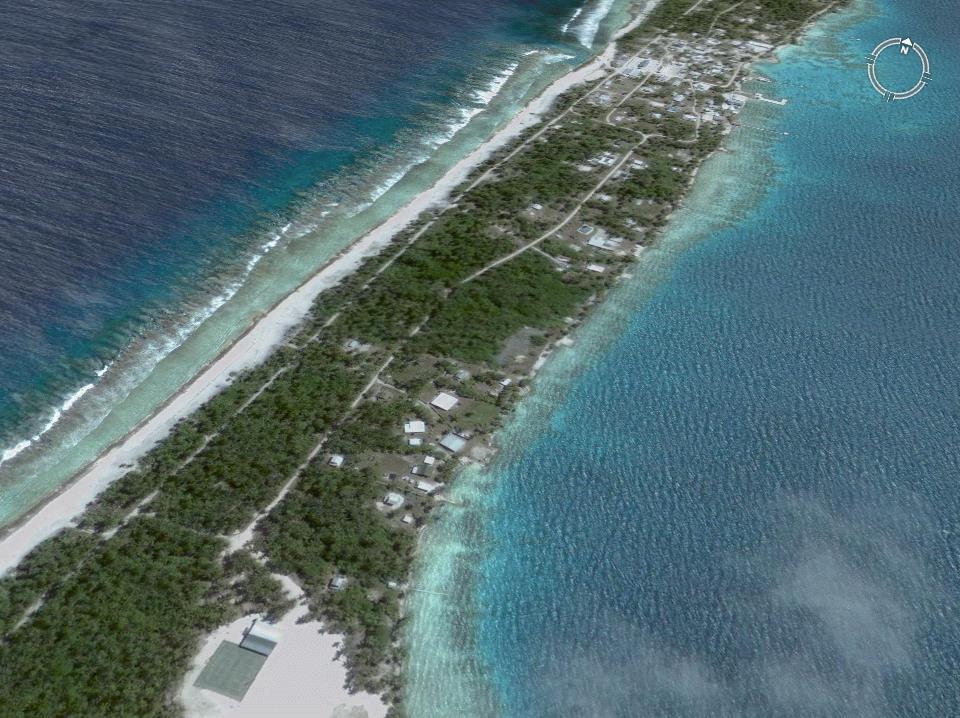
16 TC Martin: Northern Cook Is /32 TC Martin s a band of storm force winds moving at 11 kn towards Manihiki a small Coral Atoll in the Northern Cook Islands Tauhuna Village 2 NOV 1997
17 18/32
, and a highest gust of 56 kts.")
18 19/32. Martin 100km south of Manihiki at 0200UTC 2 Nov 1997 moving Towards at 11knots Tropical Cyclone Martin was quite destructive on Manihiki Atoll. When the center was closest to the island, the AWS reported a lowest pressure of 994 mb, sustained winds of 39 kts (10-min avg), and a highest gust of 56 kts. However this was the last official report from the station before it was demolished by the storm surge. There were 10 known fatalities on Manihiki with 10 more persons reported missing (and presumed drowned). Almost every building on the island was destroyed by the storm surge--even a concrete water tank broke under the onslaught of the waves.
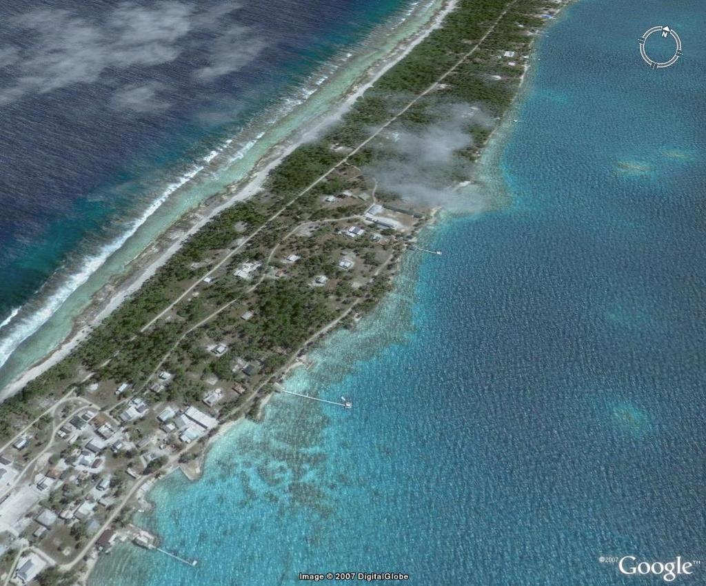
19 20/32 The side of the island which was hit has a fairly continuous solid carbonate barrier 4-5m above MSL. The waves would have pumped some considerable amount of water over this barrier which then ran downhill through the village towards the lagoon. Some people said the water was preceded by a particular loud noise perhaps indicating that it was a surge wave generating different noises from the large wind waves. The Manihiki scenario is different from the Heron Island one in that there is no reef rim off the coast which the waves have to pass. There is an irregularly shaped carbonate rock rampart stretching 50 or so metres out, submerged 2-3m, after which the depth increases rather rapidly, say1/10-1/20 and the bed is fairly flat.


20 Lat./Long every 2 degrees Manihiki W Manihiki 21/32 85 GHZ H 1846UTC 1 Nov 1997 Manihiki 85 GHZ H 0427UTC 2 Nov 1997 Microwave images show northern eye wall intensify as it approached Manihiki. Estimated band of 50kn winds through the red area. 85 GHZ H 0730UTC 2 Nov 1997


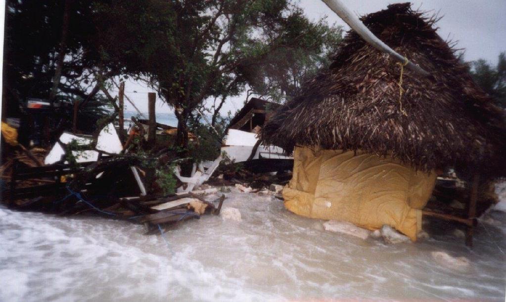
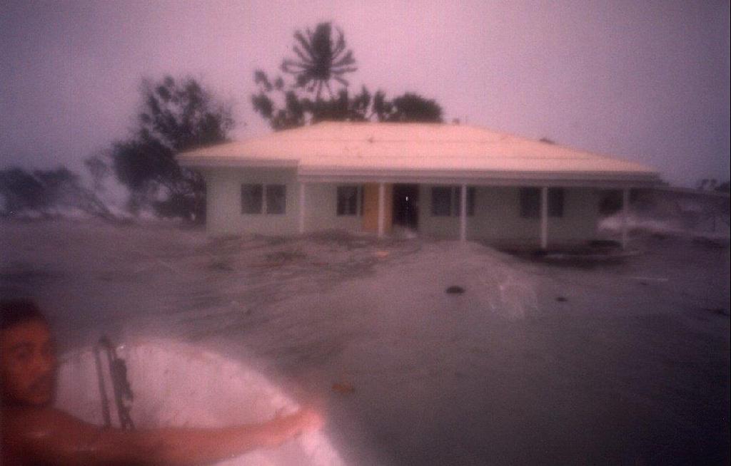
21 Wave damage at Manihiki 22/32


22 Wave damage at Manihiki 23/32
23 Transect across Tauhuna, which is on the western side of Manihiki (ie, the Martin's first impact side). The topography is related to MSL. 24/32
24 3.2.4 Fast moving tropical cyclone caused severe wave damage in Fiji. 25/32

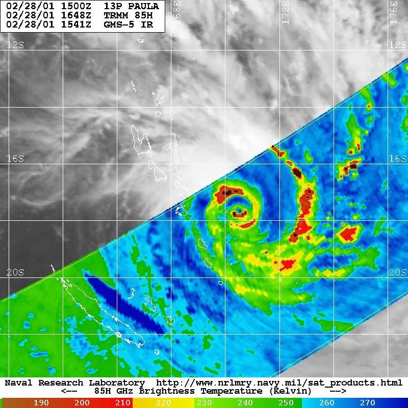
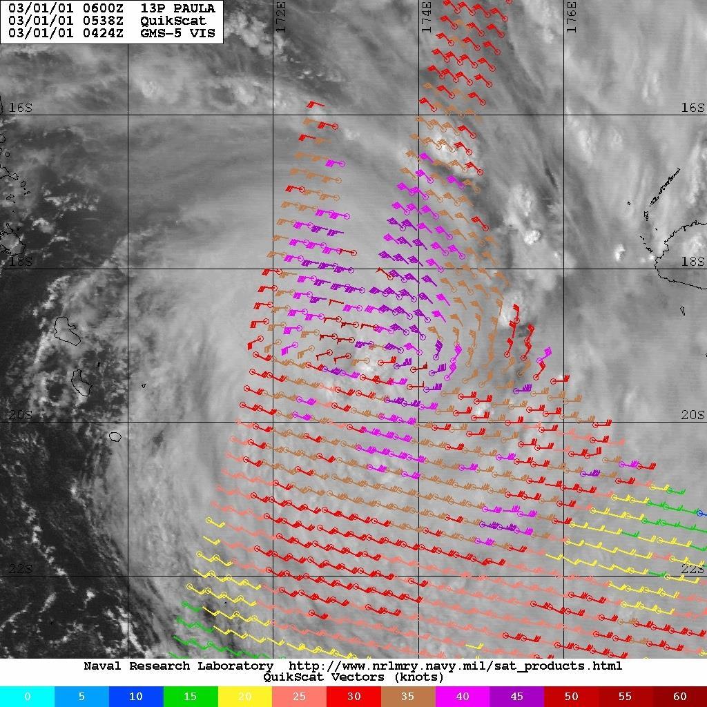
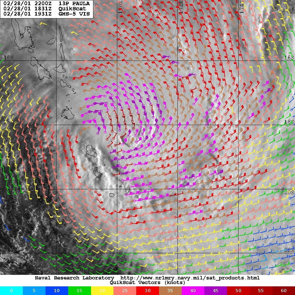
25 26/32 TC Paula impact on Fiji, 2001 Moving ESE at 19 knots. 00UTC 1Mar UTC 1Mar UTC 2Mar2001

26 27/32
27 28/32
28 Paula was a SH example of fetch enhancement in 2001 when large waves damaged parts of Fiji. In Western Division high waves destroyed or damaged a number of houses in nine villages along the Coral Coast (the South Coast of Viti Levu). The owners of these houses were forced to evacuate. Root crops, fruit trees and some sugar cane fields were damaged, by sea-borne debris. The most distant islands in Eastern Division, the Southern Lau Group also suffered damage to buildings and crops. 29/32

29 TC Meena 2005 Rarotonga 30/32

30 Meena's storm surge Avarua Harbour Rarotonga 6 Feb /32
31 Summary 32/32 Text Hazards vary with each system Intensity relates to wind, surge and wave Oceanic risk: enhanced fetch=>large waves Storm tide has potential to be the biggest impact; most difficult forecast to get right because of many factors including timing with astronomical tide

32 Rarotonga 33/32

33 Rarotonga 34/32

34 Rarotonga 35/32

35 Rescue in the Pacific 21 rescued 7 yachts and 3 people lost 36/32

36 37/32 Large swells damaged Majuro one metre seawater inundation The sea flooded 120 dwellings, damaged infrastructures and closed the airport for 48 hours. swell path
Coastal management has lagged behind the growth in population leading to problems with pollution
 Fifty percent of the population of the industrialized world lives within 100 km of a coast. Coastal management has lagged behind the growth in population leading to problems with pollution and natural
Update: UNSW s Research Program for Extreme Waves on Fringing Reefs. Matt Blacka,Kristen Splinter, Ron Cox
 Update: UNSW s Research Program for Extreme Waves on Fringing Reefs Matt Blacka,Kristen Splinter, Ron Cox Overview Research Area 1: Extreme wave and water level processes for fringing reef coastlines Research
Australian Coastal Councils Conference
 Australian Coastal Councils Conference Kiama March 2019 Where Has My Beach Gone? (and what can I do about it?) Dr Andrew McCowan Water Technology Where Has My Beach Gone? Where Has My Beach Gone? Where
Oceans and Coasts. Chapter 18
 Oceans and Coasts Chapter 18 Exploring the oceans The ocean floor Sediments thicken and the age of the seafloor increases from ridge to shore The continental shelf off the northeast United States Constituent
UNDERSTANDING STORM SURGE
 The Education Program at the New Jersey Sea Grant Consortium 22 Magruder Road, Fort Hancock, NJ 07732 (732) 872-1300 www.njseagrant.org UNDERSTANDING STORM SURGE ACTIVITY 6 SURGE OF THE STORM http://secoora.org/classroom/virtual_hurricane/surge_of_the_storm>
Nature Of Marine winds, Waves and Swells over West African Coasts Case study of Victoria Island beach in Lagos, Nigeria
 Nature Of Marine winds, Waves and Swells over West African Coasts Case study of Victoria Island beach in Lagos, Nigeria By S. O. Gbuyiro and E. Olaniyan Marine Unit, Nigeria Meteorological Agency, Lagos
Reading Material. Inshore oceanography, Anikouchine and Sternberg The World Ocean, Prentice-Hall
 Reading Material Inshore oceanography, Anikouchine and Sternberg The World Ocean, Prentice-Hall BEACH PROCESSES AND COASTAL ENVIRONMENTS COASTAL FEATURES Cross section Map view Terminology for Coastal
TRAPPED-FETCH WAVES The Theory from an Observational Perspective
 TRAPPED-FETCH WAVES The Theory from an Observational Perspective Peter J Bowyer Allan W MacAfee 50 50 45 45 40 40 35 35 System Speed (kt) System Speed (kt) 30 30 25 25 20 20 15 15 10 10 5 5 Fetch Enhancements
Shorelines Earth - Chapter 20 Stan Hatfield Southwestern Illinois College
 Shorelines Earth - Chapter 20 Stan Hatfield Southwestern Illinois College The Shoreline A Dynamic Interface The shoreline is a dynamic interface (common boundary) among air, land, and the ocean. The shoreline
Chapter 12: Coasts (after a brief review of Tides)
") Chapter 12: Coasts (after a brief review of Tides) 1 Questions from previous classes: What happens when a wave meets a current? wave = people walking current = bus If wave goes with the current, the wave
Chapter 12: Coasts (after a brief review of Tides) 1 Questions from previous classes: What happens when a wave meets a current? wave = people walking current = bus If wave goes with the current, the wave
A Coastal Storm Modeling System for determination of flood hazards along a high energy coast in response to SLR and 21 st century storms
 Li Erikson, Patrick Barnard, Andrea O Neill, Jodi Eshleman, Amy Foxgrover, Michael Fitzgibbon 2, Grant Ballard 2, Kelly Higgason 3 A Coastal Storm Modeling System for determination of flood hazards along
Chapter 10 Lecture Outline. The Restless Oceans
 Chapter 10 Lecture Outline The Restless Oceans Focus Question 10.1 How does the Coriolis effect influence ocean currents? The Ocean s Surface Circulation Ocean currents Masses of water that flow from one
Assessment of flooding on low-elevation reef-lined coasts
 Assessment of flooding on low-elevation reef-lined coasts Ap van Dongeren, Deltares, Delft, The Netherlands With Curt Storlazzi, USGS, Santa Cruz, USA Impact on coral reef-lined islands and coasts Coral
The frequently asked questions are grouped under headings to make it easier to find information -
 Tsunami Inundation Mapping for Hawke s Bay Frequently Asked Questions The frequently asked questions are grouped under headings to make it easier to find information - General tsunami information Tsunami
3.9 FROM ISLANDS TO ATOLLS
 3.9 1 3.9 FROM ISLANDS TO ATOLLS OBJECTIVES The students Listen to a description of the formation of volcanic islands, fringing reefs, barrier reefs, and atolls. Observe and participate in a simulation
SURFACE CURRENTS AND TIDES
 NAME SURFACE CURRENTS AND TIDES I. Origin of surface currents Surface currents arise due to the interaction of the prevailing wis a the ocean surface. Hence the surface wi pattern (Figure 1) plays a key
Lecture Outlines PowerPoint. Chapter 15 Earth Science, 12e Tarbuck/Lutgens
 Lecture Outlines PowerPoint Chapter 15 Earth Science, 12e Tarbuck/Lutgens 2009 Pearson Prentice Hall This work is protected by United States copyright laws and is provided solely for the use of instructors
Influence of oceanographic processes on coastal erosion, morphology and inundation
 FACULTY OF ENGINEERING, COMPUTING AND MATHEMATICS Influence of oceanographic processes on coastal erosion, morphology and inundation Charitha Pattiaratchi School of Civil, Environmental and Mining Engineering
For Educational and Non-Profit Use Only!
 This flyer was originally created and published in Japanese by Shizuoka Prefecture, Japan. UNESCO IOC ITIC provides this English translation for portions of the original document with the kind permission
There are many different kinds of beaches which are generally characterized by the dominance of waves, tides, rivers and currents, and in particular
 Fig. 11-11, p. 253 There are many different kinds of beaches which are generally characterized by the dominance of waves, tides, rivers and currents, and in particular differ by the amount of energy, which
G. Meadows, H. Purcell and L. Meadows University of Michigan
 www.coj.net/departments/fire+and+rescue/emergency+preparedness/rip+current.htm G. Meadows, H. Purcell and L. Meadows Over 80% of all surf related rescues are attributable to Rip Currents According to the
Eastern Equatorial Pacific
 Overview The is the region of open ocean directly south of Mexico and Central America (between approximately 4 o to 16 o N, and 85 o to 105 o W) (Figure 1). Major bathymetric features include Guatemala
El Niño Southern Oscillation. Pressure systems over Darwin Australia and Tahiti Oscillate Typically occurs every 4-7 years
 El Niño Southern Oscillation Pressure systems over Darwin Australia and Tahiti Oscillate Typically occurs every 4-7 years 1 2 What is it? Normal Conditions... What is it? During El Niño. 3 Local Effects
5. Tropical Cyclone Storm Surge and Open Ocean Waves
 Chapter Five Dr. Steve Lyons U.S. National Weather Service 5. Tropical Cyclone Storm Surge and Open Ocean Waves 5.1 Introduction There has been some misunderstanding about the forecasting of tropical cyclone
Define the key terms: - Abrasion - Attrition - Hydraulic action - Solution. Y11 Coasts
 Define the key terms: - Abrasion - Attrition - Hydraulic action - Solution Abrasion caused by waves picking up material which is forced against the cliff face wearing it away Attrition where stones and
An Atlas of Oceanic Internal Solitary Waves (February 2004) by Global Ocean Associates Prepared for Office of Naval Research Code 322 PO
 by Global Ocean Associates Prepared for Office of Naval Research Code 322 PO") Overview The is located in the western Pacific Ocean north of the Indonesian Island of Celebes and south of the Sulu Sea and the Philippines (Figure 1). It is a deep-water sea, roughly circular with several
Overview The is located in the western Pacific Ocean north of the Indonesian Island of Celebes and south of the Sulu Sea and the Philippines (Figure 1). It is a deep-water sea, roughly circular with several
Lessons learnt from the Samoa tsunami September a multi-disciplinary survey
 Lessons learnt from the Samoa tsunami September 2009 - a multi-disciplinary survey Stefan Reese, Jochen Bind, Graeme Smart, Shona van Zijll de Jong, William Power, Brendon Bradley, Kate Wilson, Gegar Prasetya
Ocean Waves and Surf Forecasting: Wave Climate and Forecasting
 Overview Ocean Waves and Surf Forecasting: Wave Climate and Forecasting Ocean regions Characterizing and describing ocean waves Wave theory, propagation, and dispersion Refraction, shadowing, and bathymetry
3/9/2013. Build house on cliff for a view of the ocean - be one with said view Pearson Education, Inc. Shorelines: summary in haiku form
 Introduction to Environmental Geology, 5e Edward A. Keller Shorelines: summary in haiku form Chapter 11 Coastal Processes Lecture Presentation prepared by X. Mara Chen, Salisbury University Build house
Phase-Resolving Wave Runup for Storm Inundation Assessment
 Phase-Resolving Wave Runup for Storm Inundation Assessment Jane Smith, Andrew Kennedy, Alexandros Taflanidis, Joannes Westerink, Kwok Fai Cheung, Seizo Tanaka, Aina Ota, Madeleine Hamman, Masashi Minamide,
Mouth of the Columbia River Jetties Three-Phase Construction Plan
 Mouth of the Columbia River Jetties Three-Phase Construction Plan Project Overview October 9, 2012 US Army Corps of Engineers MCR Jetties Major Rehabilitation Sand Island pile dikes 1930-1935 Columbia
Figure 1 GE image of the Costa Sur & EcoEléctrica power plants, located inside Guayanilla and Tallaboa bay.
 1 7 - STORM SURGES IN PUERTO RICO_Power Plants-Costa Sur & EcoElectrica Costa Sur & EcoEléctrica Figure 1 shows a GE image of the Costa Sur (Guayanilla) and EcoElectrica site. Figure 2 shows the topographic
Waves. Swell, Surf, and Tides
 Waves Swell, Surf, and Tides Tsunamis Tsunamis Waves of Destruction Seismic Sea Waves Seismic Sea Waves Most tsunamis are generated by earthquakes Seismic Sea Waves Most tsunamis are generated by earthquakes
Shore - place where ocean meets land Coast - refers to the larger zone affected by the processes that occur at this boundary.
 Waves, Beaches, and Coasts Shore - place where ocean meets land Coast - refers to the larger zone affected by the processes that occur at this boundary. Waves: energy moving through water The height of
Chapter 22, Section 1 - Ocean Currents. Section Objectives
 Chapter 22, Section 1 - Ocean Currents Section Objectives Intro Surface Currents Factors Affecting Ocean Currents Global Wind Belts (you should draw and label a diagram of the global wind belts) The Coriolis
Questions # 4 7 refer to Figure # 2 (page 321, Fig )
") Shoreline Community College OCEANOGRAPHY 101 Fall 2006 Sample Exam # 3 Instructor: Linda Khandro Questions # 1 3 refer to Figure # 1 (page 284, Fig 11.7) 1. At which position is the moon in its new moon
Shoreline Community College OCEANOGRAPHY 101 Fall 2006 Sample Exam # 3 Instructor: Linda Khandro Questions # 1 3 refer to Figure # 1 (page 284, Fig 11.7) 1. At which position is the moon in its new moon
LAB: WHERE S THE BEACH
 Name: LAB: WHERE S THE BEACH Introduction When you build a sandcastle on the beach, you don't expect it to last forever. You spread out your towel to sunbathe, but you know you can't stay in the same spot
The Storm Surge Hazard 2018 TS-8 Tropical Meteorology 2
 The Storm Surge Hazard 2018 TS-8 Tropical Meteorology 2 Daniel Noah National Weather Service Tampa Bay daniel.noah@noaa.gov Tropical Cyclone Storm Surge Is a large dome of water, often 50 to 100 miles
consulting engineers and scientists
 consulting engineers and scientists Coastal Processes Presented by: January 9, 2015 Varoujan Hagopian, P.E. F.ASCE Senior Consultant, Waterfront Engineer Living Shoreline Workshop Lets Remember Why We
The Wet and Wild Winter of in west Cornwall
 DECEMBER 2013 The Wet and Wild Winter of 2013-2014 in west Cornwall It all started so benignly, then after a lovely sunny day with light winds on the 16 th, the unsettled, very wet and sometimes stormy
Overview. Beach Features. Coastal Regions. Other Beach Profile Features. CHAPTER 10 The Coast: Beaches and Shoreline Processes.
 Overview CHAPTER 10 The Coast: Beaches and Shoreline Processes Coastal regions constantly change. The beach is a dominant coastal feature. Wave activity continually modifies the beach and coastal areas.
Inspection of Clarence City Beaches following Winter 2011 Storm Events
 18 July 2011 WRL Ref: WRL10086TDS L20110718 Messrs P Watson & I Preece Clarence City Council PO Box 96 Rosny Park TAS 7018 By email: pwatson@ccc.tas.gov.au ipreece@ccc.tas.gov.au Dear Phil/Ian, Inspection
Impact of the loss of QuikSCAT on National Hurricane Center operations: Current mitigation efforts and future plans
 Impact of the loss of QuikSCAT on National Hurricane Center operations: Current mitigation efforts and future plans Rick Danielson1 and Mike Brennan NOAA/NWS/NCEP National Hurricane Center 1 UCAR visiting
Figure 4, Photo mosaic taken on February 14 about an hour before sunset near low tide.
 The Impact on Great South Bay of the Breach at Old Inlet Charles N. Flagg and Roger Flood School of Marine and Atmospheric Sciences, Stony Brook University Since the last report was issued on January 31
CMS Modeling of the North Coast of Puerto Rico
 CMS Modeling of the North Coast of Puerto Rico PRESENTED BY: Dr. Kelly Rankin Legault, Ph.D., P.E. 1 Dr. Alfredo Torruella, Ph.D. 2 1 USACE Jacksonville District 2 University of Puerto Rico October 2016
Introduction to Storm Surge
 Introduction to Storm Surge Hurricane Katrina (2005) Mississippi 1200 deaths, $108 billion damage Hurricane Sandy (2012) Northeast U.S. 73 deaths, $65 billion damage Hurricane Ike (2008) - Bolivar Peninsula,
Environmental Geology Chapter 11 COASTAL PROCESSES and RELATED HAZARDS
 Environmental Geology Chapter 11 COASTAL PROCESSES and RELATED HAZARDS Introduction >50% of world population concentrated in the coastal zones ~75% of U.S. population living in coastal states Coastal hazard
Swell and Wave Forecasting
 Lecture 25 Swell and Wave Forecasting Swell and Wave Forecasting Motivation Terminology Wave Formation Wave Decay Wave Refraction Shoaling Rouge Waves 1 2 Motivation In Hawaii, surf is the number one weather-related
COMMENTS FOR THE NSF TSUNAMI WORKSHOP AT HILO, HAWAII, DECEMBER 2006 By Robert L. Wiegel
 COMMENTS FOR THE NSF TSUNAMI WORKSHOP AT HILO, HAWAII, 26-28 DECEMBER 2006 By Robert L. Wiegel 1. Introduction 2. Risk, Adjustment, Mitigation 3. Hilo, Hawaii 4. Designing for Tsunamis: Seven Principles
City of Del Mar Local Coastal Plan (LCP) Amendment for Sea Level Rise and Coastal Flooding
 Amendment for Sea Level Rise and Coastal Flooding") City of Del Mar Local Coastal Plan (LCP) Amendment for Sea Level Rise and Coastal Flooding 6/22/17 Presentation to Sea Level Rise Stakeholder- Technical Advisory Committee (STAC) Nick Garrity, P.E. Lindsey
City of Del Mar Local Coastal Plan (LCP) Amendment for Sea Level Rise and Coastal Flooding 6/22/17 Presentation to Sea Level Rise Stakeholder- Technical Advisory Committee (STAC) Nick Garrity, P.E. Lindsey
Swell and Wave Forecasting
 Lecture 24 Part II Swell and Wave Forecasting 29 Swell and Wave Forecasting Motivation Terminology Wave Formation Wave Decay Wave Refraction Shoaling Rouge Waves 30 Motivation In Hawaii, surf is the number
Impacts of breakwaters and training walls
 Across the eastern seaboard of Australia, breakwaters and training walls have instigated fundamental perturbations to coastal and estuary processes. This has induced long-term changes to foreshore alignments,
WHAT IS A TSUNAMI? happens.nz. Long or Strong GET GONE TSUNAMI 101
 WHAT IS A TSUNAMI? A tsunami is a series of powerful waves with strong currents. They are mostly caused by underwater or coastal earthquakes, and sometimes by underwater landslides or volcanic eruptions.
Environmental Protection on the Gold Coast of Queensland, Australia. 1. What is the appeal of the Gold Coast to tourists?
 Environmental Protection on the Gold Coast of Queensland, Australia Sections 1. What is the appeal of the Gold Coast to tourists? 2. How are Gold Coast visitor trends changing? 3. How can the impacts of
Waves. G. Cowles. General Physical Oceanography MAR 555. School for Marine Sciences and Technology Umass-Dartmouth
 Waves G. Cowles General Physical Oceanography MAR 555 School for Marine Sciences and Technology Umass-Dartmouth Waves Sound Waves Light Waves Surface Waves Radio Waves Tidal Waves Instrument Strings How
Response of a Newly Created Marsh-Wetland Affected by Tidal Forcing, Upland Discharge, and Groundwater Interaction
 Response of a Newly Created Marsh-Wetland Affected by Tidal Forcing, Upland Discharge, and Groundwater Interaction Mouth of Columbia River, Cape Disappointment State Park, Washington 12 Hans R. Moritz
Essentials of Oceanography Eleventh Edition
 Chapter Chapter 1 10 Clickers Lecture Essentials of Oceanography Eleventh Edition The Coast: Beaches and Shoreline Processes Alan P. Trujillo Harold V. Thurman Chapter Overview Coastal regions have distinct
Appendix M: Durras Lake Tailwater Conditions
 Appendix M: Durras Lake Tailwater Conditions M.1 Preamble WRL has completed a tailwater condition assessment for the entrance to Durras Lake, to be used as an ocean boundary condition for a future flood
Impact of Hurricane Matthew on the Atlantic Coast of Florida
 Impact of Hurricane Matthew on the Atlantic Coast of Florida A coastal engineer was driving across country and his jeep broke down in front of a monastery. It was late in the day and the monks invited
Marginal Marine Environments
 Marginal Marine Environments Delta: discrete shoreline protuberances formed where rivers enter oceans, semi-enclosed seas, lakes or lagoons and supply sediment more rapidly than it can be redistributed
folk Island Key features
 Majuro RU n Tarawa Howland (USA) Baker (USA) KIRIBATI 2.2 Cook Islands Pahuyra (USA) (USA) COOK ISLANDS Pago Pago American Samoa Cook Islands Kiribati ISLANDS Tuvalu Tokelau Kiribati rt Vila Wallis and
Chapter - Oceans and Coasts
 Chapter - Oceans and Coasts Discussion: What do oceans contribute to the environment of Earth? How do Earth s major systems relate to the oceans? Oceans and Coasts Oceans are important - Thermal regulation
Chapter 20 Lecture. Earth: An Introduction to Physical Geology. Eleventh Edition. Shorelines. Tarbuck and Lutgens Pearson Education, Inc.
 Chapter 20 Lecture Earth: An Introduction to Physical Geology Eleventh Edition Shorelines Tarbuck and Lutgens The Shoreline: A Dynamic Interface The Coastal Zone The shoreline is constantly modified by
Private Bag X097, Pretoria, 0001 Tel: + 27 (0) USSD: *120*7297#
 USSD: *120*7297#") Private Bag X097, Pretoria, 0001 Tel: + 27 (0) 12 367 6000 www.weathersa.co.za USSD: *120*7297# FQZA31 FAPR 241330 SECURITE: ========= WEATHER BULLETIN FOR THE HIGH SEAS FOR METAREA VII. ISSUED BY THE
Private Bag X097, Pretoria, 0001 Tel: + 27 (0) 12 367 6000 www.weathersa.co.za USSD: *120*7297# FQZA31 FAPR 241330 SECURITE: ========= WEATHER BULLETIN FOR THE HIGH SEAS FOR METAREA VII. ISSUED BY THE
Chuki Hongo 1, Haruko Kurihara 1, Yimnang Golbuu 2. PICRC Technical Report No
 Projecting the effectiveness of coral reefs in mitigating the impact from sea-level rise and tropical cyclones on the coastline of Melekeok, Palau to the end of the 21 st Century Chuki Hongo 1, Haruko
GEOS 201 Lab 13 Climate of Change InTeGrate Module Case studies 2.2 & 3.1
 Discerning Patterns: Does the North Atlantic oscillate? Climate variability, or short term climate change, can wreak havoc around the world. Dramatic year to year shifts in weather can have unanticipated
Draft Coastal Zone Management Plan for Byron Shire Coastline
 Byron Shire Council Draft Coastal Zone Management Plan for Byron Shire Coastline 26 November 2010 #1030842 Presentation Outline o o o o o o o Brief Byron Shire erosion history What is a CZMP? Why Develop
Taranaki Tsunami Inundation Analysis. Prepared for Taranaki Civil Defence Emergency Management Group. Final Version
 Taranaki Tsunami Inundation Analysis Prepared for Taranaki Civil Defence Emergency Management Group Final Version June 2012 AM 12/07 HBRC Plan Number 4362 Asset Management Group Technical Report Prepared
Evaluation of June 9, 2014 Federal Emergency Management Agency Flood Insurance Study for Town of Weymouth, Norfolk, Co, MA
 Evaluation of June 9, 2014 Federal Emergency Management Agency Flood Insurance Study for Town of Weymouth, Norfolk, Co, MA Prepared For: Woodard & Curran 95 Cedar Street, Suite 100 Providence, RI 02903
Sand Bank Passage. Fiji nearshore wave hindcast ' ' 19 00'
 Sand Bank Passage Fiji nearshore wave hindcast 1 00' 1 00' 1 30' 1 00' 177 00' 177 30' 17 00' 17 30' 17 30' Figure 1. Location maps of the site. The map on the left shows the region. The map on the right
Mango Bay_Resort. Fiji nearshore wave hindcast ' ' 19 00'
 Mango Bay_Resort Fiji nearshore wave hindcast 1 00' 1 30' 1 00' 177 00' 177 30' 17 00' 17 30' Figure 1. Location maps of the site. The map on the left shows the region. The map on the right shows the island
OECS Regional Engineering Workshop September 29 October 3, 2014
 B E A C H E S. M A R I N A S. D E S I G N. C O N S T R U C T I O N. OECS Regional Engineering Workshop September 29 October 3, 2014 Coastal Erosion and Sea Defense: Introduction to Coastal Dynamics David
Baraga County, MI Coastal Hazard Analysis Flood Risk Review Meeting. July 12, 2018
 Baraga County, MI Coastal Hazard Analysis Flood Risk Review Meeting July 12, 2018 Agenda Introductions Coastal Flood Risk Study and Mapping Program Current Status Technical Overview of Study and Mapping
SUSTAINABLE DEVELOPMENT: CIVIL ENGINEERING AND THE BUILT ENVIRONMENT. INTERNATIONAL CONFERENCE Malta 5 th May 2011
 SUSTAINABLE DEVELOPMENT: CIVIL ENGINEERING AND THE BUILT ENVIRONMENT Malta 5 th May 2011 Wave Forces: Tsunami And Sea Wind Driven in the Mediterranean: Malta s Scenario Tsunami wave hitting sea wall in
Kavala Bay. Fiji nearshore wave hindcast ' ' 19 00'
 Kavala Bay Fiji nearshore wave hindcast 1 00' 19 00' 1 30' 19 00' 1 00' 1 30' 1 00' 1 30' 1 30' Figure 1. Location maps of the site. The map on the left shows the region. The map on the right shows the
The Surge of the Storm By Margaret Olsen and Katie Greganti
 The Surge of the Storm By Margaret Olsen and Katie Greganti Grade Level: 5-12 Type of Activity: Hands on Focus Question: How does a hurricane s storm surge of a hurricane affect the low-lying areas along
Chesil Beach, Dorset UK High energy, shingle coastline. Brighton Beach, Sussex UK Pebble beach
 Beaches: Depositional landform Extends from the highest high tide to the lowest low tide. Very important temporary store in coastal system. Accretion: sediment returning to the visible portion of a beach
General Coastal Notes + Landforms! 1
 General Coastal Notes + Landforms! 1 Types of Coastlines: Type Description Primary Coast which is essentially in the same condition when sea level stabilized Coastline after the last ice age, younger.
Lecture 13 El Niño/La Niña Ocean-Atmosphere Interaction. Idealized 3-Cell Model of Wind Patterns on a Rotating Earth. Previous Lecture!
 Lecture 13 El Niño/La Niña Ocean-Atmosphere Interaction Previous Lecture! Global Winds General Circulation of winds at the surface and aloft Polar Jet Stream Subtropical Jet Stream Monsoons 1 2 Radiation
The Movement of Ocean Water. Currents
 The Movement of Ocean Water Currents Ocean Current movement of ocean water that follows a regular pattern influenced by: weather Earth s rotation position of continents Surface current horizontal movement
St. Louis County, MN Coastal Hazard Analysis Flood Risk Review Meeting. May 2, 2018
 St. Louis County, MN Coastal Hazard Analysis Flood Risk Review Meeting May 2, 2018 Agenda Introductions Coastal Flood Risk Study and Mapping Program Current Status Technical Overview of Study and Mapping
The Case of the Disappearing Shoreline
 Name The Case of the Disappearing Shoreline Humans change the earth's climate in many ways. One change is the increase of carbon dioxide in the atmosphere. As we burn more fossil fuels, we release more
THE INEVITABLE RIPPLE 2ND OF APRIL TSUNAMI
 THE INEVITABLE RIPPLE 2ND OF APRIL TSUNAMI Structure Background Preparedness for 2nd of April Response Operations 2nd of April Lessons learnt Future work Hawaii 1957 Background Approx 250,000 people live
LOCALLY CONCENTRATED SEVERE BEACH EROSION ON SEISHO COAST CAUSED BY TYPHOON T0709
 F-4 Fourth International Conference on Scour and Erosion 2008 LOCALLY CONCENTRATED SEVERE BEACH EROSION ON SEISHO COAST CAUSED BY TYPHOON T0709 Yoshimitsu TAJIMA 1 and Shinji SATO 2 1 Member of JSCE, Associate
The ocean water is dynamic. Its physical
 CHAPTER MOVEMENTS OF OCEAN WATER The ocean water is dynamic. Its physical characteristics like temperature, salinity, density and the external forces like of the sun, moon and the winds influence the movement
3 Maps and Charts In order to navigate we need to use some form of map. The two choices are nautical charts, or land maps.
 13 3 Maps and Charts In order to navigate we need to use some form of map. The two choices are nautical charts, or land maps. Charts Nautical Charts only show the land detail that is visible from the sea.
Bayfield & Ashland Counties, WI Coastal Hazard Analysis Flood Risk Review Meeting. June 05, 2018
 Bayfield & Ashland Counties, WI Coastal Hazard Analysis Flood Risk Review Meeting June 05, 2018 Agenda Introductions Coastal Flood Risk Study and Mapping Program Current Status Technical Overview of Study
The History of Coastal Flood Hazard Assessments in the Great Lakes
 The History of Coastal Flood Hazard Assessments in the Great Lakes Brian A. Caufield, P.E., CFM June 23, 2016 2 The Great Lakes Some Statistics Courtesy of Great Lakes Information Network One-fifth of
Appendix D: SWAN Wave Modelling
 Appendix D: SWAN Wave Modelling D.1 Preamble The Eurobodalla Shire Council area is subject to extreme waves originating from offshore storms. When swell waves approach the coast, they are modified by the
Tsunami Preparedness in the Capital Region
 Tsunami Preparedness in the Capital Region A presentation by: the CRD Local Government Emergency Program Advisory Commission (LG EPAC) and your community emergency programs What is a tsunami? A tsunami
Oceans Humans both depend on it and threaten it with their activities
 Oceans Humans both depend on it and threaten it with their activities Oceans Water covers nearly ¾ of the Earth s surface More than 50% of the world s population lives within an hour of the coast Oceans
STATUS REPORT FOR THE SUBMERGED REEF BALL TM ARTIFICIAL REEF SUBMERGED BREAKWATER BEACH STABILIZATION PROJECT FOR THE GRAND CAYMAN MARRIOTT HOTEL
 August 23 STATUS REPORT FOR THE SUBMERGED REEF BALL TM ARTIFICIAL REEF SUBMERGED BREAKWATER BEACH STABILIZATION PROJECT FOR THE GRAND CAYMAN MARRIOTT HOTEL performed by Lee E. Harris, Ph.D., P.E. Consulting
Tidal Amplitude and Wave Setup in Trained and Untrained River Entrances.
 Tidal Amplitude and Wave Setup in Trained and Untrained River Entrances. Theo Moura 1, Mohammad Olfateh 1, David Callaghan 1, Peter Nielsen 1, Bob You 2 and Tom Baldock 1 1 School of Civil Engineering,
Coastal Inundation. An Overview for TCDC
 Coastal Inundation An Overview for TCDC Rick Liefting Team Leader Regional Hazards and Environmental Compliance Integrated Catchment Management Waikato Regional Council Photo: Sugar Loaf Wharf, Coromandel.
The Impact on Great South Bay of the Breach at Old Inlet Charles N. Flagg School of Marine and Atmospheric Sciences, Stony Brook University
 The Impact on Great South Bay of the Breach at Old Inlet Charles N. Flagg School of Marine and Atmospheric Sciences, Stony Brook University The previous report provided a detailed look at the conditions
A process based approach to understand WA s complex coastline Jeff Hansen Ryan Lowe Graham Symonds Laura Segura Gundula Winter
 A process based approach to understand WA s complex coastline Jeff Hansen Ryan Lowe Graham Symonds Laura Segura Gundula Winter WA s coastline is highly variable due to offshore and shore-attached coral
Preliminary analysis of wind data from South Channel Island
 Preliminary analysis of wind data from South Channel Island Introduction Many people expressed concern that deepening the shipping channel a further 5 metres at the Entrance to Port Phillip Bay would permanently
Directed Reading. Section: Ocean Currents. a(n). FACTORS THAT AFFECT SURFACE CURRENTS
. FACTORS THAT AFFECT SURFACE CURRENTS") Skills Worksheet Directed Reading Section: Ocean Currents 1. A horizontal movement of water in a well-defined pattern is called a(n). 2. What are two ways that oceanographers identify ocean currents? 3.
Skills Worksheet Directed Reading Section: Ocean Currents 1. A horizontal movement of water in a well-defined pattern is called a(n). 2. What are two ways that oceanographers identify ocean currents? 3.
Hydrodynamic and hydrological modelling to support the operation and design of sea ports
 Hydrodynamic and hydrological modelling to support the operation and design of sea ports Data needs and examples Martijn de Jong (port/nautical requirements, waves, currents) Sofia Caires (mean and extreme
Beach Profiles. Topics. Module 9b Beach Profiles and Crossshore Sediment Transport 3/23/2016. CE A676 Coastal Engineering
 Beach Profiles AND CROSS-SHORE TRANSPORT Orson P. Smith, PE, Ph.D., Professor Emeritus Topics Features of beach and nearshore profiles Equilibrium profiles Cross-shore transport References Text (Sorensen)