Coastal Inundation. An Overview for TCDC
|
|
|
- Avice Palmer
- 5 years ago
- Views:
Transcription

1 Coastal Inundation An Overview for TCDC Rick Liefting Team Leader Regional Hazards and Environmental Compliance Integrated Catchment Management Waikato Regional Council Photo: Sugar Loaf Wharf, Coromandel. Jan , Stuart Crawley, WRC
2 What we will be covering Coastal inundation concepts Event frequency (how big, how often?) Coastal Inundation Tool Current and proposed updated MfE guidance WRC s role in coastal inundation
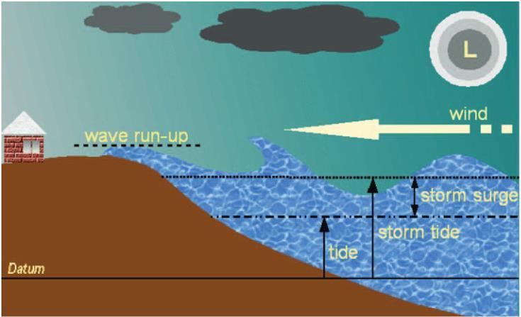
3 Coastal Inundation Inundation along the coast and within estuaries caused by: Astronomical Tides Climate (sea temperature changes) Storm Surge wind set up and Barometric pressure (1 HPa = 1 cm) Storm Tide = Astronomical Tides + Storm Surge Wave effects Wave Set up ( static water level along the coast) Wave Run up ( Swash of wave up the beach/coast) Effects of Climate Change Sea level rise Increased frequency and Intensity of storm and wave events

4 King Tides November, 2016 Kaiaua (Firth of Thames)

5 King Tides November, 2016 Thames (Firth of Thames)
6
7
8 Astronomical Tides Relatively easy to obtain and are district wide Tide range varies Vertical datum is based on Astronomical tides Mean Sea Level. Moturiki VD 1953 (MVD) Auckland VD 1946 (+ 0.9 mm w.r.t MVD) Tararu Local VD 1952 (+ 128 mm w,r,t MVD) Sea level have been increasing at ~1.7 mm/year Therefore, add ~ 0.1m to obtain current MSL.
9 Assessment of Coastal Inundation Hazard Currently no regional or district wide assessment of Coastal inundation hazard or risk Some site specific assessments (Resource Consents) Determination of Storm Tide can be under taken at a district level (i.e. East coast Coromandel) Wave effects are tricky to predict and are very site specific LiDAR of coastal area up to 20 m elevation
10 Assessment of Coastal Inundation Hazard Static water level = Tides + Storm + Climate+ SLR Affects all coastal areas (i.e. Inland from the coast) Relatively easy to assess and map Dynamic water level = Wave Set up/run up Affects the coastal margins only Open coast vs inland coast (estuaries/harbours) Landward extent variable depending on topography and roughness Very site specific (compare Tairua vs Pauanui)
11 Event Frequency The size of an event is based on the frequency or probability of the event occurring over a period of time. Based on measured/historical information. Average Return Interval Frequency that an event of a certain size will occur (e.g. 100 y ARI) Annual Exceedance Probability (AEP) probability that an event will be exceeded in any one year (e.g. 1% AEP)
12 Event Frequency Return Period (y) Annual Exceedance Probability (AEP) Time Period (y) - approx % 75% 97% 100% 100% 100% 100% 100% % 36% 67% 89% 99% 100% 100% 100% % 19% 41% 65% 88% 99% 100% 100% % 10% 23% 40% 64% 92% 99% 100% % 4% 10% 18% 33% 64% 87% 98% % 2% 5% 10% 18% 39% 63% 87% % 1% 2% 5% 10% 22% 39% 63%
13 Event Frequency Return Period (y) Annual Exceedance Probability (AEP) Time Period (y) - approx % 75% 97% 100% 100% 100% 100% 100% % 36% 67% 89% 99% 100% 100% 100% % 19% 41% 65% 88% 99% 100% 100% % 10% 23% 40% 64% 92% 99% 100% % 4% 10% 18% 33% 64% 87% 98% % 2% 5% 10% 18% 39% 63% 87% % 1% 2% 5% 10% 22% 39% 63%
14 Event Frequency Return Period (y) Annual Exceedance Probability (AEP) Time Period (y) - approx % 75% 97% 100% 100% 100% 100% 100% % 36% 67% 89% 99% 100% 100% 100% % 19% 41% 65% 88% 99% 100% 100% % 10% 23% 40% 64% 92% 99% 100% % 4% 10% 18% 33% 64% 87% 98% % 2% 5% 10% 18% 39% 63% 87% % 1% 2% 5% 10% 22% 39% 63%
15 Event Frequency Return Period (y) Annual Exceedance Probability (AEP) Time Period (y) - approx % 75% 97% 100% 100% 100% 100% 100% % 36% 67% 89% 99% 100% 100% 100% % 19% 41% 65% 88% 99% 100% 100% % 10% 23% 40% 64% 92% 99% 100% % 4% 10% 18% 33% 64% 87% 98% % 2% 5% 10% 18% 39% 63% 87% % 1% 2% 5% 10% 22% 39% 63%
16 Event Frequency Return Period (y) Annual Exceedance Probability (AEP) Time Period (y) - approx % 75% 97% 100% 100% 100% 100% 100% % 36% 67% 89% 99% 100% 100% 100% % 19% 41% 65% 88% 99% 100% 100% % 10% 23% 40% 64% 92% 99% 100% % 4% 10% 18% 33% 64% 87% 98% % 2% 5% 10% 18% 39% 63% 87% % 1% 2% 5% 10% 22% 39% 63%
17 Wave surge Whitianga March /
18 Tararu Tide Gauge (Firth of Thames) AEP (%) ARI (years) Water level (m) Diff (m) Extreme Storm Tide analyse (NIWA 2015)
19 Tararu Tide Gauge (Firth of Thames) AEP (%) ARI (years) Water level (m) Diff (m) Extreme Storm Tide analyse (NIWA 2015) y 100 y % 99% % 87% % 63%
20 Tararu Tide Gauge (Firth of Thames) AEP (%) ARI (years) Water level (m) Diff (m) Extreme Storm Tide analyse (NIWA 2015) y 100 y % 99% % 87% % 63%
21 Tararu Tide Gauge (Firth of Thames) AEP (%) ARI (years) Water level (m) Diff (m) Extreme Storm Tide analyse (NIWA 2015) y 100 y % 99% % 87% % 63%
22 Better way to inform about event frequency? Niwa (Scott Stephens) doing some great work to determine: How many times will this place get affected And How many more times with Climate Change Provides better context in terms of assessing Risk as Acceptable/Tolerable/Intolerable

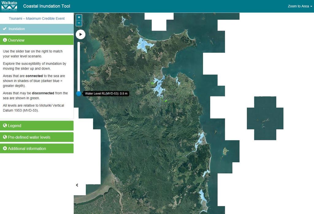
23 Coastal Inundation Tool
24 What is it? Web based tool that allows users to explore present day and future susceptibility of coastal inundation from tides and storm tides along Waikato coastlines.
25 Why do we need it? High demand for information on potential effects of present day and future coastal inundation levels. Public Local councils Insurance Life line utilities Difficult to visualise a number and explore scenarios Emergency Management


26 Whitianga Waterways, 24 June 2017 Source: Thomas Everett

27 King Tides November, 2016 Thames (Firth of Thames)
28 What does it show? Present Day Coastal Water Level Estimates Tide Model and Tide Gauges Low air pressure On shore winds X Wave Effects Storm Effects Tide Effects Upper Storm Tide (worst case) Lower Storm Tide (semi annual) Max Tide MHWS Datum (Moturiki Vertical Datum 1953)
29 What does it show? Future Coastal Water Levels Sea Level Rise added to Present Day Values Storm Effects Tide Effects Upper Storm Tide (worst case) Lower Storm Tide (semi annual) Max Tide MHWS Datum (Moturiki Vertical Datum 1953)
30 What does it show? Future Coastal Water Levels Sea Level Rise component added to Present Day Values Storm Effects Tide Effects Upper Storm Tide (worst case) Lower Storm Tide (semi annual) Max Tide MHWS Datum (Moturiki Vertical Datum 1953)
31 Pre-defined Water Level Firth of Thames Coro West Coast Coro East Coast Scenarios Thames Coro Harbour Mercury Bay Present Day Future Projected 0.5 m projected Sea Level Rise 1.0 m projected Sea Level Rise Mean High Water Spring (m) Max High Tide (m) Storm Tide Range (Estimate) Lower (m) Upper (m) Mean High Water Spring (m) Max High Tide (m) Storm Tide Range (Estimate) Lower (m) Upper (m) Mean High Water Spring (m) Max High Tide (m) Storm Tide Range (Estimate) Lower (m) Upper (m)


32 Pauanui Waterways Tairua Harbour King Tides February 2, 2014 Gangways underwater Whitianga - Buffalo Beach (Mercury Bay)


33 Public road Tairua - Paku Boat Ramp Tairua Fishing Club, tide coming up through stormwater drains
34 How does it work? Simple Bath Tub Model Water levels mapped at 0.2 m increments Connected inundation (blue shaded areas), areas where water could directly flow to the sea. Disconnected inundation (green areas), areas that are at or below a chosen water level, but may have no direct flow path to the sea. Slider bar on tool controls mapped water levels
35 How do you use it? Zoom to area of interest Choose Water Level Scenario for area of interest Choose Pre-defined User defined Match nearest mapped water level with chosen water level scenario Explore susceptibility raise and lower water level

36 Sugar Loaf Wharf, Coromandel Harbour - Jan Photo: Sugar Loaf Wharf, Coromandel. Jan , Stuart Crawley, WRC

37 Sugar Loaf Wharf, Coromandel Harbour - Jan Photo: Sugar Loaf Wharf, Coromandel. Jan , Stuart Crawley, WRC
38 What else do you need to know? Does not define coastal inundation hazard areas Does not recommend minimum floor levels Does identify areas that are potentially susceptible to coastal inundation that may require further assessment Also shows Tsunami Maximum Credible Event inundation where available Updated with new information as required

39 Where do I find it?
40 Coastal Hazards and Climate Change Guidance- MfE 2016 Heads up to TCDC - Section 5.7 Discussion on future projections and guidance
41 Timeline Final DRAFT completed Early 2017 Further review to be undertaken. ***7 Slides removed as MfE document not Published***
42 Coastal Policy Statement 2010 Policy 24: Identification of coastal hazards Identify areas in the coastal environment that are potentially affected by coastal hazards (including tsunami), giving priority to the identification of areas at high risk of being affected. Hazard risks, over at least 100 years, are to be assessed having regard to: physical drivers and processes that cause coastal change including sea level rise; short-term and long-term natural dynamic fluctuations of erosion and accretion; geomorphological character; the potential for inundation of the coastal environment, taking into account potential sources, inundation pathways and overland extent; cumulative effects of sea level rise, storm surge and wave height under storm conditions; influences that humans have had or are having on the coast; the extent and permanence of built development; and the effects of climate change on: matters (a) to (g) above; storm frequency, intensity and surges; and coastal sediment dynamics; taking into account national guidance and the best available information on the likely effects of climate change on the region or district.
43 Policy 25: Subdivision, use, and development in areas of coastal hazard risk In areas potentially affected by coastal hazards over at least the next 100 years: avoid increasing the risk 10 of social, environmental and economic harm from coastal hazards; avoid redevelopment, or change in land use, that would increase the risk of adverse effects from coastal hazards; encourage redevelopment, or change in land use, where that would reduce the risk of adverse effects from coastal hazards, including managed retreat by relocation or removal of existing structures or their abandonment in extreme circumstances, and designing for relocatability or recoverability from hazard events; encourage the location of infrastructure away from areas of hazard risk where practicable; discourage hard protection structures and promote the use of alternatives to them, including natural defences; and consider the potential effects of tsunami and how to avoid or mitigate them.
44 WRC role in coastal hazards Supply of information/monitoring Tide gauges, beach profile and shoreline monitoring Technical advice and guidance Assist Resource Consents Public information Coastal Inundation Tool Upcoming Hazards Portal Public Flood information requests (included coastal hazards) Conduit to Central Govt. guidance and advice. Waikato Regional Hazards Forum

45 (Source: T&T 2014) Beach Profile Sites Survey up to 6 times per year Currently reviewing effectiveness Testing drones and LiDAR
46 Region wide shoreline mapping Mapping historical shorelines from aerial imagery The purpose of this process is: To identify longterm trends of shoreline movement and form a basic region-wide baseline understanding of how our coast changes. To extend our monitoring beyond beaches (i.e. to include environments such as cliffs and estuaries). As a first pass to identify any critical areas that need more detailed monitoring. To inform the public about how the regions shoreline has changed.
2 How do I use the Coastal Inundation Tool?
 Coastal Inundation Tool Guidance 1 Overview The Coastal Inundation Tool provides users with a tool to quickly understand the susceptibility of coastal areas to coastal inundation due to tides, storms and
Town of Duck, North Carolina
 Tracking No. 00.00.2010 Erosion Mitigation And Shoreline Management Feasibility Study Town of Duck, North Carolina Coastal Planning & Engineering of North Carolina August 15, 2012 Tom Jarrett Robert Neal
Sea-level rise: How are we tracking in Wellington region & how will it effect coastal flooding? Dr Rob Bell NIWA, Hamilton
 Sea-level rise: How are we tracking in Wellington region & how will it effect coastal flooding? Dr Rob Bell NIWA, Hamilton Coastal adaptation in NZ: Starting-block issues with sea-level rise Tell us what
Sussex County, DE Preliminary Study Overview
 Sussex County, DE Preliminary Study Overview Coastal study scope: 102 miles of entire County shoreline Revised 102 panels for coastal study Riverine study scope: 14 streams, 67.1 miles, within the Nanticoke
The Eastern Coromandel Tsunami Strategy. Managing tsunami risks in Mercury Bay
 The Eastern Coromandel Tsunami Strategy Managing tsunami risks in Mercury Bay January 2017 Why are we working on the Eastern Coromandel Tsunami Strategy? The release of the Review of Tsunami Hazard in
Boothbay Harbor Rotary Club May 12, 2016
 Mapping Potential Sea Level Rise and Storm Surge in Boothbay Harbor, ME Boothbay Harbor Rotary Club May 12, 2016 Peter A. Slovinsky, Marine Geologist Maine Geological Survey S.M. Dickson, MGS Quickly,
The effect of sea-level rise on the frequency of extreme sea levels in New Zealand. Prepared for Parliamentary Commissioner for the Environment
 The effect of sea-level rise on the frequency of extreme sea levels in New Zealand Prepared for Parliamentary Commissioner for the Environment July 2015 Prepared by: Scott Stephens For any information
Taranaki Tsunami Inundation Analysis. Prepared for Taranaki Civil Defence Emergency Management Group. Final Version
 Taranaki Tsunami Inundation Analysis Prepared for Taranaki Civil Defence Emergency Management Group Final Version June 2012 AM 12/07 HBRC Plan Number 4362 Asset Management Group Technical Report Prepared
City of Del Mar Local Coastal Plan (LCP) Amendment for Sea Level Rise and Coastal Flooding
 Amendment for Sea Level Rise and Coastal Flooding") City of Del Mar Local Coastal Plan (LCP) Amendment for Sea Level Rise and Coastal Flooding 6/22/17 Presentation to Sea Level Rise Stakeholder- Technical Advisory Committee (STAC) Nick Garrity, P.E. Lindsey
City of Del Mar Local Coastal Plan (LCP) Amendment for Sea Level Rise and Coastal Flooding 6/22/17 Presentation to Sea Level Rise Stakeholder- Technical Advisory Committee (STAC) Nick Garrity, P.E. Lindsey
SUPPLEMENTAL DOCUMENT SEA LEVEL RISE SCENARIO SELECTION AND DESIGN TIDE CALCULATION
 SUPPLEMENTAL DOCUMENT SEA LEVEL RISE SCENARIO SELECTION AND DESIGN TIDE CALCULATION FOR THE GUIDANCE FOR INCORPORATING SEA LEVEL RISE INTO CAPITAL PLANNING IN SAN FRANCISCO: ASSESSING VULNERABILITY AND
The frequently asked questions are grouped under headings to make it easier to find information -
 Tsunami Inundation Mapping for Hawke s Bay Frequently Asked Questions The frequently asked questions are grouped under headings to make it easier to find information - General tsunami information Tsunami
4/06/2014. Need for Guidance. East Coast Lows. Catchment and coastal flood events can combine! Project 18 ARR Review
 Need for Guidance Development of Practical Guidance for Coincidence of Catchment Flooding and Oceanic Inundation Angela Toniato, NSW OEH Duncan McLuckie, NSW OEH Grantley Smith, Water Research Laboratory
To: William Woods, Jenni Austin Job No: CentrePort Harbour Deepening Project - Comments on community queries
 Memo To: William Woods, Jenni Austin From: Richard Reinen-Hamill Date: Subject: cc: 1 Purpose This memo sets out our response to issues raised at and after Seatoun community consultation sessions held
LOCAL COASTAL PROGRAM UPDATE
 LOCAL COASTAL PROGRAM UPDATE Agenda Meeting #1 General Information (1 1:45 pm) Introductions and Background Grants involved What is a Local Coastal Program? What is required? LCP Update tasks and schedule
INTRODUCTION TO COASTAL ENGINEERING
 The University of the West Indies Organization of American States PROFESSIONAL DEVELOPMENT PROGRAMME: COASTAL INFRASTRUCTURE DESIGN, CONSTRUCTION AND MAINTENANCE A COURSE IN COASTAL DEFENSE SYSTEMS I CHAPTER
Tsunamis. Tsunamis COMMUNITY EMERGENCY RESPONSE TEAM TSUNAMIS
 Tsunamis Tsunamis Tell the participants that tsunamis are ocean waves that are produced by underwater earthquakes or landslides. The word is Japanese and means harbor wave because of the devastating effects
Coastal Hazards Study
 Coastal Hazards Study 2212 Beach Boulevard, Pacifica Prepared for: EXECUTIVE SUMMARY City of Pacifica 170 Santa Maria Ave Pacifica, CA 94044 Prepared by: moffatt & nichol 2185 N. California Blvd. Walnut
CHAPTER 8 ASSESSMENT OF COASTAL VULNERABILITY INDEX
 124 CHAPTER 8 ASSESSMENT OF COASTAL VULNERABILITY INDEX 8.1 INTRODUCTION In order to assess the vulnerability of the shoreline considered under this study against the changing environmental conditions,
A Coastal Storm Modeling System for determination of flood hazards along a high energy coast in response to SLR and 21 st century storms
 Li Erikson, Patrick Barnard, Andrea O Neill, Jodi Eshleman, Amy Foxgrover, Michael Fitzgibbon 2, Grant Ballard 2, Kelly Higgason 3 A Coastal Storm Modeling System for determination of flood hazards along
April 7, Prepared for: The Caribbean Disaster Emergency Response Agency Prepared by: CEAC Solutions Co. Ltd.
 April 7, 2006 Prepared for: The Caribbean Disaster Emergency Response Agency Prepared by: Introduction CEAC Solutions Co. Ltd was commissioned in May 2005 to prepare coastal beach erosion hazard maps for
Community vulnerability to elevated sea level and coastal tsunami events in Otago
 Community vulnerability to elevated sea level and coastal tsunami events in Otago Otago Regional Council Private Bag 1954, 70 Stafford St, Dunedin 9054 Phone 03 474 0827 Fax 03 479 0015 Freephone 0800
Appendix M: Durras Lake Tailwater Conditions
 Appendix M: Durras Lake Tailwater Conditions M.1 Preamble WRL has completed a tailwater condition assessment for the entrance to Durras Lake, to be used as an ocean boundary condition for a future flood
Figure 1 GE image of the Costa Sur & EcoEléctrica power plants, located inside Guayanilla and Tallaboa bay.
 1 7 - STORM SURGES IN PUERTO RICO_Power Plants-Costa Sur & EcoElectrica Costa Sur & EcoEléctrica Figure 1 shows a GE image of the Costa Sur (Guayanilla) and EcoElectrica site. Figure 2 shows the topographic
Future Condi,ons coastal hazard modeling and mapping
 Future Condi,ons coastal hazard modeling and mapping Presented by Bob Ba:alio, PE Environmental Science Associates, Inc. (ESA) On behalf of the physical processes team (USGS, TerraCosta- Scripps, ESA)
Citrus, Hernando, and Pasco Coastal Hazard Analysis. Flood Risk Review Meeting Citrus, Hernando, and Pasco Counties, Florida December 14, 2017
 Citrus, Hernando, and Pasco Coastal Hazard Analysis Flood Risk Review Meeting Citrus, Hernando, and Pasco Counties, Florida December 14, 2017 Introductions Risk MAP Project Team FEMA Region IV RAMPP (study
Technical Brief - Wave Uprush Analysis Island Harbour Club, Gananoque, Ontario
 Technical Brief - Wave Uprush Analysis RIGGS ENGINEERING LTD. 1240 Commissioners Road West Suite 205 London, Ontario N6K 1C7 October 31, 2014 Table of Contents Section Page Table of Contents... i List
VENICE LOCAL COASTAL PROGRAM UPDATE: COASTAL HAZARDS WELCOME
 VENICE LOCAL COASTAL PROGRAM UPDATE: COASTAL HAZARDS WELCOME 1 Introducing the Team Hosted by the Department of City Planning and grant funded in part by the California Coastal Commission 2 Workshop Purpose
Project Incorporation of Sea Level Rise City of Newport Beach Approach for Balboa Islands, City of Newport Beach, California
 Project Incorporation of Sea Level Rise City of Newport Beach Approach for Balboa Islands, City of Newport Beach, California Ying Poon, Everest International Consultants, Inc. CMANC Annual Winter Meeting
Sea Level Rise and Coastal Flooding Why Waves Matter!
 Sea Level Rise and Coastal Flooding Why Waves Matter! Jason D. Burtner Massachusetts Office of Coastal Zone Management South Shore Regional Coordinator Sea Level Rise and Coastal Storm Damage and Flooding
ST LEONARDS COASTAL HAZARD VULNERABILITY ASSESSMENT
 Level 12, 333 Collins Street Melbourne VIC 3000 Australia Telephone: +61 3 8676 3500 Facsimile: +61 3 8676 3505 www.worleyparsons.com WorleyParsons Services Pty Ltd ABN 61 001 279 812 23 November 2011
EXISTING AND PLANNED STRATEGIES AND ACTIONS CONNECTED WITH COASTAL PROTECTION IN ASPECT OF PREDICTED SEA LEVEL RISE
 EXISTING AND PLANNED STRATEGIES AND ACTIONS CONNECTED WITH COASTAL PROTECTION IN ASPECT OF PREDICTED SEA LEVEL RISE Andrzej Cieślak Long term coastal protection strategy In 2000 a new 1 Polish long term
U.S. Army Engineer Institute for Water Resources
 Sea Level Change Curve Calculator (2014.88) (DRAFT) U.S. Army Engineer Institute for Water Resources Table of Contents 1. INTRODUCTION... 2 1.1 BACKGROUND... 2 1.1.1 INFORMATION QUALITY ACT... 2 1.2 OVERVIEW...
APPENDIX D-2. Sea Level Rise Technical Memo
 APPENDIX D-2 Sea Level Rise Technical Memo 2185 N. California Blvd., Suite 500 Walnut Creek, CA 94596 (925) 944-5411 Fax: (925) 944-4732 www.moffattnichol.com DRAFT MEMORANDUM To: From: Neil Nichols,
Leaning Into Adaptation
 www.marinslr.org Leaning Into Adaptation GFNMS Ocean Summit, May 17, 2016 Jack Liebster, Planning Manager, Marin County Marin County C-SMART Sea Level Rise Adaptation Process Evaluate Science Info. Implement
SACO RIVER AND CAMP ELLIS BEACH SACO, MAINE SECTION 111 SHORE DAMAGE MITIGATION PROJECT APPENDIX F ECONOMIC ASSESSMENT
 SACO RIVER AND CAMP ELLIS BEACH SACO, MAINE SECTION 111 SHORE DAMAGE MITIGATION PROJECT APPENDIX F ECONOMIC ASSESSMENT Department of the Army New England District, Corps of Engineers 696 Virginia Road
Bob Battalio, PE Chief Engineer, ESA September 8, 2016
 RELATING FUTURE COASTAL CONDITIONS TO EXISTING FEMA FLOOD HAZARD MAPS Technical Methods Manual Bob Battalio, PE Chief Engineer, ESA September 8, 2016 FMA 2016 Sacramento, California DWR-OST-SIO PILOTING
Managing tsunami risks in Tairua and Pauanui
 THE EASTERN COROMANDEL TSUNAMI STRATEGY Managing tsunami risks in Tairua and Pauanui Tairua-Pauanui Tsunami Working Group December 2013 Why are we working on the Eastern Coromandel Tsunami Strategy? The
Assessing Tidal Flood Risk in Ireland: Modelling, Mapping & Forecasting Coastal and Tidal Flood Risk for Irish APSFRs
 Assessing Tidal Flood Risk in Ireland: Modelling, Mapping & Forecasting Coastal and Tidal Flood Risk for Irish APSFRs Dr. John Martin C.Eng. OPW Flood Risk Assessment & Management Section, Ireland WG-F
Chapter 3: Coastal Characteristics
 11 Chapter 3: Coastal Characteristics The coastal environment is the area lying at the interface between land and the sea. The area includes both the zone of shallow water within which waves are able to
The Storm Surge Hazard 2018 TS-8 Tropical Meteorology 2
 The Storm Surge Hazard 2018 TS-8 Tropical Meteorology 2 Daniel Noah National Weather Service Tampa Bay daniel.noah@noaa.gov Tropical Cyclone Storm Surge Is a large dome of water, often 50 to 100 miles
FEMA Region V. Great Lakes Coastal Flood Study. Pilot Study Webinar. Berrien County, Michigan. February 26, 2014
 FEMA Region V Great Lakes Coastal Flood Study Pilot Study Webinar Berrien County, Michigan February 26, 2014 2 Pilot Study Webinar Agenda Great Lakes Coastal Flood Study Background Demonstration Project
EROSION MECHANICS OF A CARBONATE- TOMBOLO BEACH IN MIYAKOJIMA ISLAND, OKINAWA PREFECTURE, JAPAN.
 EROSION MECHANICS OF A CARBONATE- TOMBOLO BEACH IN MIYAKOJIMA ISLAND, OKINAWA PREFECTURE, JAPAN. Ryuichiro NISHI 1, Takaaki UDA 2, Akio KIKUCHI 3 and Kou FURUIKE 4 1) Associate Prof. Dept. of Ocean Civil
Technical Article No. 2.3
 Technical Article No. 2.3 INTRODUCTION Estuary, stream and river entrances can experience significant natural shoreline changes, typically much larger than experienced on other areas of the same coast.
In order to better manage coastline hazards, it is necessary to first understand the various processes that cause them. The waves, water levels and
 In 2015 Council worked with coastal engineering consultants to complete a detailed analysis of coastal processes and the risks from coastal hazards along the coastal zone of the Shire. This study looked
Evaluation of June 9, 2014 Federal Emergency Management Agency Flood Insurance Study for Town of Weymouth, Norfolk, Co, MA
 Evaluation of June 9, 2014 Federal Emergency Management Agency Flood Insurance Study for Town of Weymouth, Norfolk, Co, MA Prepared For: Woodard & Curran 95 Cedar Street, Suite 100 Providence, RI 02903
Joint-probability of storm tide and waves on the open coast of Wellington
 Joint-probability of storm tide and waves on the open coast of Wellington Prepared for Greater Wellington Regional Council July 2011 (minor edits July 2012) Authors/Contributors: Scott Stephens Richard
Q1. What are the primary causes/contributors to coastal erosion at Westshore and the concept of longshore / littoral drift.
 Q1. What are the primary causes/contributors to coastal erosion at Westshore and the concept of longshore / littoral drift. In order of (timing related) contribution to present problem 1. Beach is too
2016 NC Coastal Local Governments Annual Meeting
 2016 NC Coastal Local Governments Annual Meeting Coastal Flood Study Modeling and Mapping 101 April 21, 2016 Tom Langan, PE, CFM Engineering Supervisor NCEM Floodplain Mapping Program FEMA Coastal Flood
Climate Change Risks for Victoria s Surf Coast
 Climate Change Risks for Victoria s Surf Coast Craig A, Clifton 1, Dan Ware 1, Simon Coverdale 2 and Chloe Hanson-Boyd 1 1 Sinclair Knight Merz, Melbourne, AUSTRALIA. email: cclifton@globalskm.com 2 Great
REPORT. Coastal Flood Hazard Zones for Select Northland Sites Update
 1 REPORT Coastal Flood Hazard Zones for Select Northland Sites 2017 Update Prepared for Prepared by Date Job Number 1001049 Document Control Title: Coastal Flood Hazard Zones for Select Northland Sites
The History of Coastal Flood Hazard Assessments in the Great Lakes
 The History of Coastal Flood Hazard Assessments in the Great Lakes Brian A. Caufield, P.E., CFM June 23, 2016 2 The Great Lakes Some Statistics Courtesy of Great Lakes Information Network One-fifth of
Draft Coastal Zone Management Plan for Byron Shire Coastline
 Byron Shire Council Draft Coastal Zone Management Plan for Byron Shire Coastline 26 November 2010 #1030842 Presentation Outline o o o o o o o Brief Byron Shire erosion history What is a CZMP? Why Develop
Influence of oceanographic processes on coastal erosion, morphology and inundation
 FACULTY OF ENGINEERING, COMPUTING AND MATHEMATICS Influence of oceanographic processes on coastal erosion, morphology and inundation Charitha Pattiaratchi School of Civil, Environmental and Mining Engineering
Tsunami Preparedness in the Capital Region
 Tsunami Preparedness in the Capital Region A presentation by: the CRD Local Government Emergency Program Advisory Commission (LG EPAC) and your community emergency programs What is a tsunami? A tsunami
Managing tsunami risks in Matarangi and Whangapoua
 THE EASTERN COROMANDEL TSUNAMI STRATEGY Managing tsunami risks in Matarangi and Whangapoua Matarangi Beach Whangapoua Beach December 2015 Why are we working on the Eastern Coromandel Tsunami Strategy?
Australian Coastal Councils Conference
 Australian Coastal Councils Conference Kiama March 2019 Where Has My Beach Gone? (and what can I do about it?) Dr Andrew McCowan Water Technology Where Has My Beach Gone? Where Has My Beach Gone? Where
NYS Coastal Waters. Water Resources of NYS: THE NATURE of the COASTAL ZONE. NYS Coastal Waters. NYS Coastal Atlas. Coastal Zone Management 10/10/2014
 Water Resources of NYS: THE NATURE of the COASTAL ZONE NYS Coastal Waters NYS is the only state to border the Atlantic Ocean and the Great Lakes (Lakes Erie and Ontario). Great Lakes shoreline: 577 miles
COASTAL ENVIRONMENTS. 454 lecture 12
 COASTAL ENVIRONMENTS Repeated movement of sediment & water constructs a beach profile reflecting the balance between average daily or seasonal wave forces and resistance of landmass to wave action Coasts
Assateague Island National Seashore North End Restoration Project Timeline
 Assateague Island National Seashore North End Restoration Project Timeline Date Event Some information provided in the Project Introduction document. Detailed events are available in a timeline compiled
Inventory of coastal sandy areas protection of infrastructure and planned retreat
 2018-02-28 Inventory of coastal sandy areas protection of infrastructure and planned retreat Johanna Birgander, Thorbjörn Nilsson, Pär Persson Summary To estimate the natural protection around the coast
What are we adapting to? David Provis Senior Principal, Oceanography, Cardno Member, Victorian Coastal Council
 What are we adapting to? David Provis Senior Principal, Oceanography, Cardno Member, Victorian Coastal Council Sea-level -NOAA Sea-level - NOAA 90% probability ranges Sea-level - NOAA Sea-level Port Phillip
County of Santa Barbara Permit Option Analysis Goleta Beach JULY 13, 2017
 County of Santa Barbara Permit Option Analysis Goleta Beach JULY 13, 2017 Introduction 2 Goleta Beach Park welcomes 1.5 million visitors annually Amenities include: Picnic Areas and Group Areas w/bbqs
SHOREHAM BEACH LOCAL NATURE RESERVE
 SHOREHAM BEACH LOCAL NATURE RESERVE Coastal Geography Education Programme 2014-15 S. Savage 2014 COASTAL GEOGRAPHY OPPORTUNITIES Shoreham Beach Shoreham Beach is a shingle spit formed over many centuries
UNDERSTANDING STORM SURGE
 The Education Program at the New Jersey Sea Grant Consortium 22 Magruder Road, Fort Hancock, NJ 07732 (732) 872-1300 www.njseagrant.org UNDERSTANDING STORM SURGE ACTIVITY 6 SURGE OF THE STORM http://secoora.org/classroom/virtual_hurricane/surge_of_the_storm>
Figure 4, Photo mosaic taken on February 14 about an hour before sunset near low tide.
 The Impact on Great South Bay of the Breach at Old Inlet Charles N. Flagg and Roger Flood School of Marine and Atmospheric Sciences, Stony Brook University Since the last report was issued on January 31
Beach profile surveys and morphological change, Otago Harbour entrance to Karitane May 2014 to June 2015
 Beach profile surveys and morphological change, Otago Harbour entrance to Karitane May 2014 to June 2015 Prepared for Port Otago Ltd Martin Single September 2015 Shore Processes and Management Ltd Contact
Environmental Protection on the Gold Coast of Queensland, Australia. 1. What is the appeal of the Gold Coast to tourists?
 Environmental Protection on the Gold Coast of Queensland, Australia Sections 1. What is the appeal of the Gold Coast to tourists? 2. How are Gold Coast visitor trends changing? 3. How can the impacts of
Lecture Outlines PowerPoint. Chapter 15 Earth Science, 12e Tarbuck/Lutgens
 Lecture Outlines PowerPoint Chapter 15 Earth Science, 12e Tarbuck/Lutgens 2009 Pearson Prentice Hall This work is protected by United States copyright laws and is provided solely for the use of instructors
Collaboration: Sea-level Marin Adaptation Response Team (C-SMART)
") Collaboration: Sea-level Marin Adaptation Response Team (C-SMART) Photo Credit : Lighthawk Aerial Community Development Agency 3501 Civic Center Drive, Rm. 308 San Rafael, CA 94903 415 4736269 T www.marinslr.org
Collaboration: Sea-level Marin Adaptation Response Team (C-SMART) Photo Credit : Lighthawk Aerial Community Development Agency 3501 Civic Center Drive, Rm. 308 San Rafael, CA 94903 415 4736269 T www.marinslr.org
Shorelines Earth - Chapter 20 Stan Hatfield Southwestern Illinois College
 Shorelines Earth - Chapter 20 Stan Hatfield Southwestern Illinois College The Shoreline A Dynamic Interface The shoreline is a dynamic interface (common boundary) among air, land, and the ocean. The shoreline
Future Coasts Port Fairy Coastal Hazard Assessment
 Future Coasts Port Fairy Coastal Hazard Assessment WRL Technical Report 2012/21 April 2013 by F Flocard, J T Carley, D S Rayner, P F Rahman and I R Coghlan Water Research Laboratory University of New South
Coastal Hazards Management Plan Marengo to Skenes Creek
 Coastal Hazards Management Plan Marengo to Skenes Creek October 2012 ISO 9001 QEC22878 SAI Global DOCUMENT STATUS Version Doc type Reviewed by Approved by Date issued v04 Final Report GLR TJW 26/10/2012
Understanding the Tsunami Wave
 The First Tsunami attack on Sri Lanka Krakatoa Island 27 th August 1883 Understanding the Tsunami Wave Generation Propagation Nearshore Transformation Shoreline Entry Inland Dissipation 1 Generation and
Chapter - Oceans and Coasts
 Chapter - Oceans and Coasts Discussion: What do oceans contribute to the environment of Earth? How do Earth s major systems relate to the oceans? Oceans and Coasts Oceans are important - Thermal regulation
Technical Brief - Wave Uprush Analysis 129 South Street, Gananoque
 Technical Brief - Wave Uprush Analysis 129 South Street, Gananoque RIGGS ENGINEERING LTD. 1240 Commissioners Road West Suite 205 London, Ontario N6K 1C7 June 12, 2013 Table of Contents Section Page Table
4/20/17. #30 - Coastlines - General Principles Coastlines - Overview
 Writing Assignment Due one week from today by 11:59 pm See main class web pages for detailed instructions Essays will be submitted in Illinois Compass (instructions later) Pick one: Earthquakes, tsunamis,
Oceans and Coasts. Chapter 18
 Oceans and Coasts Chapter 18 Exploring the oceans The ocean floor Sediments thicken and the age of the seafloor increases from ridge to shore The continental shelf off the northeast United States Constituent
K V Thomas Centre for Earth Science Studies, Thiruvananthapuram , India
 Setback lines for Coastal Regulation Zone Different approaches and implications K V Thomas Centre for Earth Science Studies, Thiruvananthapuram - 695031, India Email: thomas.cess@gmail.com 1.0 Introduction
Tsunami Preparedness in the Capital Region
 Tsunami Preparedness in the Capital Region A presentation by: the CRD Local Government Emergency Program Advisory Commission (LG EPAC) and your community emergency programs What is a tsunami? A tsunami
FEMA West Coast Sea Level Rise Pilot Study
 FEMA West Coast Sea Level Rise Pilot Study Ed Curtis, P.E., CFM FEMA Region IX June 4, 2014 Presentation Objectives Present the goals of the FEMA West Coast Sea Level Rise Pilot Study Review the SLR Pilot
Appendix D: SWAN Wave Modelling
 Appendix D: SWAN Wave Modelling D.1 Preamble The Eurobodalla Shire Council area is subject to extreme waves originating from offshore storms. When swell waves approach the coast, they are modified by the
Bay County, MI Coastal Hazard Analysis Flood Risk Review Meeting. May 14, 2018
 Bay County, MI Coastal Hazard Analysis Flood Risk Review Meeting May 14, 2018 Agenda Introductions Coastal Flood Risk Study and Mapping Program Current Status Technical Overview of Study and Mapping Floodplain
Investigation of the Impact of Beach Raking on Beach Accretion/Erosion: West End Beaches of Galveston Island, Texas 2007/ 2008
 Investigation of the Impact of Beach Raking on Beach Accretion/Erosion: West End Beaches of Galveston Island, Texas 2007/ 2008 By Robert Webster 1, Timothy Dellepenna Ph.D. 1, 1 Texas A&M at Galveston
Beach Profiles. Topics. Module 9b Beach Profiles and Crossshore Sediment Transport 3/23/2016. CE A676 Coastal Engineering
 Beach Profiles AND CROSS-SHORE TRANSPORT Orson P. Smith, PE, Ph.D., Professor Emeritus Topics Features of beach and nearshore profiles Equilibrium profiles Cross-shore transport References Text (Sorensen)
Safe Asset Management - Coastal and Estuarial Defences
 Safe Asset Management - Coastal and Signatures removed from electronic version Submitted by Synopsis Sets out requirements for the examination of works protecting the railway infrastructure from sea and
Open Pacific Coast Study. California Coastal Analysis and Mapping Project
 Open Pacific Coast Study California Coastal Analysis and Mapping Project September 2012 California Open Coast Counties California Coastal Analysis and Mapping Project This publication is an initiative
Unit 11 Lesson 2 How Does Ocean Water Move? Copyright Houghton Mifflin Harcourt Publishing Company
 Unit 11 Lesson 2 How Does Ocean Water Move? Catch a Wave A wave is the up-and-down movement of surface water. Catch a Wave Catch a Wave (wave effects) Surface waves are caused by wind pushing against
Beach Change in the Auckland Region: Current State and Trends. December 2016 Technical Report 2016/048
 Beach Change in the Auckland Region: Current State and Trends December 2016 Technical Report 2016/048 Beach Change in the Auckland Region: Current State and Trends December 2016 Technical Report 2016/048
NORTHERN CELL OPTIONS SHORTLIST RECOMMENDATIONS
 OPTIONS SHORTLIST RECOMMENDATIONS Coastal Unit C: Bayview Options recommended for MCDA scoring. Status quo. Planting 3. Renourishment (gravel) 6. Beach-scraping 7. Restore shingle crest. Inundation accommodation
Photo by: Darryl Hatheway, 2011
 Photo by: Darryl Hatheway, 2011 September 11, 2015 Presentation Discussion Examine PFD V-Zone Mapping in Wave Runup Dominated West Coast Application of PFD V-Zone Mapping Criteria in Pacific G&S PFD V-Zone
Southwest Washington Littoral Drift Restoration Project: Design, Construction, and Monitoring
 Southwest Washington Littoral Drift Restoration Project: Design, Construction, and Monitoring J Jessica i St Stokke kk USACE Portland District October 28, 2010 WEDA Pacific Meeting Monterey, CA US Army
SAND BOTTOM EROSION AND CHANGES OF AN ACTIVE LAYER THICKNESS IN THE SURF ZONE OF THE NORDERNEY ISLAND
 SAND BOTTOM EROSION AND CHANGES OF AN ACTIVE LAYER THICKNESS IN THE SURF ZONE OF THE NORDERNEY ISLAND Kos'yan R. 1, Kunz H. 2, Podymov l. 3 1 Prof.Dr.,The Southern Branch of the P.P.Shirshov Institute
THE INEVITABLE RIPPLE 2ND OF APRIL TSUNAMI
 THE INEVITABLE RIPPLE 2ND OF APRIL TSUNAMI Structure Background Preparedness for 2nd of April Response Operations 2nd of April Lessons learnt Future work Hawaii 1957 Background Approx 250,000 people live
Compiled by Uwe Dornbusch. Edited by Cherith Moses
 REPORT ON WAVE AND TIDE MEASUREMENTS Compiled by Uwe Dornbusch. Edited by Cherith Moses 1 Aims...1 2 Summary...1 3 Introduction...1 4 Site selection...1 5 Wave recorder settings...2 6 Results...2 6.1 Water
Cross-shore sediment transports on a cut profile for large scale land reclamations
 Cross-shore sediment transports on a cut profile for large scale land reclamations Martijn Onderwater 1 Dano Roelvink Jan van de Graaff 3 Abstract When building a large scale land reclamation, the safest
SURGE SUPPRESSION ACHIEVED BY DIFFERENT COASTAL SPINE (IKE DIKE) ALIGNMENTS. Bruce A. Ebersole, Thomas W. Richardson and Robert W.
 ALIGNMENTS. Bruce A. Ebersole, Thomas W. Richardson and Robert W.") SURGE SUPPRESSION ACHIEVED BY DIFFERENT COASTAL SPINE (IKE DIKE) ALIGNMENTS Abstract Bruce A. Ebersole, Thomas W. Richardson and Robert W. Whalin, Jackson State University, Jackson, Mississippi The primary
SURGE SUPPRESSION ACHIEVED BY DIFFERENT COASTAL SPINE (IKE DIKE) ALIGNMENTS Abstract Bruce A. Ebersole, Thomas W. Richardson and Robert W. Whalin, Jackson State University, Jackson, Mississippi The primary
The Dynamic Coast. Right Place Resources. A presentation about the interaction between the dynamic coast and people
 The Dynamic Coast Houses threatened by coastal erosion in California Right Place Resources A presentation about the interaction between the dynamic coast and people For the rest of the presentations in
4.1 Analysis of Shoreline Surveys
 4.0 COASTAL EROSION HAZARD ASSESSMENT There has been considerable net coastal erosion at the southern end of Muriwai Beach over the last few decades (Cato, 1987). This chapter examines the trend for shoreline
STATUS REPORT FOR THE SUBMERGED REEF BALL TM ARTIFICIAL REEF SUBMERGED BREAKWATER BEACH STABILIZATION PROJECT FOR THE GRAND CAYMAN MARRIOTT HOTEL
 August 23 STATUS REPORT FOR THE SUBMERGED REEF BALL TM ARTIFICIAL REEF SUBMERGED BREAKWATER BEACH STABILIZATION PROJECT FOR THE GRAND CAYMAN MARRIOTT HOTEL performed by Lee E. Harris, Ph.D., P.E. Consulting
MODELING OF CLIMATE CHANGE IMPACTS ON COASTAL STRUCTURES - CONTRIBUTION TO THEIR RE-DESIGN
 Proceedings of the 14 th International Conference on Environmental Science and Technology Rhodes, Greece, 3-5 September 2015 MODELING OF CLIMATE CHANGE IMPACTS ON COASTAL STRUCTURES - CONTRIBUTION TO THEIR