VIRGINIA BARRIER ISLAND BACKGROUND
|
|
|
- Chrystal Bishop
- 5 years ago
- Views:
Transcription
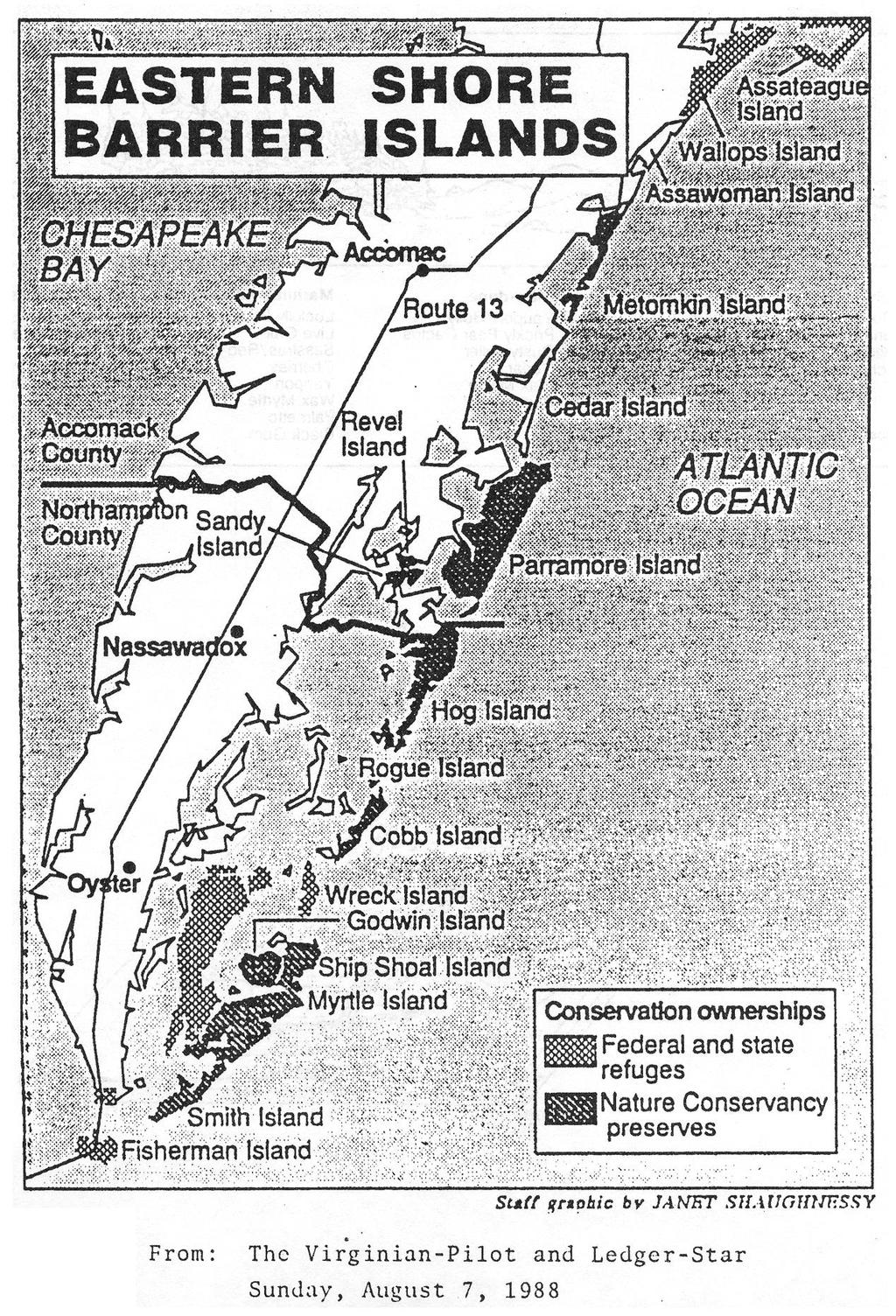
1 VIRGINIA BARRIER ISLAND BACKGROUND Virginia's barrier islands are part of a barrier island chain extending 2,700 miles from Maine to Texas. These thin strips of sand provide valuable habitat for wildlife, protect the mainland from the storm-driven fury of the ocean, and attract thousands of vacationers in the summer. For these varied reasons, the barrier islands of Virginia are important natural resources. If improperly managed, these islands could be lost; therefore, they are an ecosystem that deserve our attention. The Islands and Their Location Virginia's barrier island system is composed of 13 islands stretching 75 miles along the oceanside of the Eastern Shore. The southernmost island is Fisherman, at the mouth of the Chesapeake Bay. Fisherman Island is the smallest of the barrier islands, only 1 mile in length. Although crossed by the Chesapeake Bay Bridge Tunnel, the island is not generally open to visitors. It is a national wildlife refuge managed for the benefit of nesting shorebirds that spend the spring and summer there. Smith, Myrtle, and Ship Shoal islands are the next three islands to the north of Fisherman. They are owned by The Nature Conservancy, a private conservation organization. As part of the Conservancy's Virginia Coast Reserve, these islands are maintained as undeveloped natural areas. Although there are some restrictions, the islands are open to the public. Access is not easy, however, because the islands are not connected to the mainland and the only way to get to them is by boat. The purpose of keeping these areas undeveloped and of limiting public access is to preserve a natural beach system for future generations to enjoy. Wreck Island is owned by the Virginia Division of Parks. It is also maintained as an undeveloped natural area with limited public access. To the north of Wreck Island are Cobb, Hog, and Parramore islands. They are natural areas in the Virginia Coast Reserve. These islands at one time had thriving communities, but were abandoned when shoreline erosion began to take its toll. Domestic animals such as goats and cattle, left behind by the residents, survived in the wild on the islands. Many of these animals were finally rounded up and removed to the mainland by the Nature Conservancy. The domestic animals were disturbing the natural habitats and native animal species on the islands. In contrast to the islands of the Coast Reserve, Cedar is a privately owned island that has been developed. Beach cottages line the oceanfront where grass-covered dunes would otherwise stand. It resembles the resort beaches of the East Coast rather than its neighboring barrier islands. Beyond Cedar Island is Metompkin, the northernmost island in the Virginia Coast Reserve. With Metompkin, Parramore, Hog, Cobb, Ship Shoal, Myrtle, and Smith islands, the oceanfront property managed by The Nature Conservancy totals 50 miles. The other privately owned island in Virginia's chain is Assawoman Island. The Nature Conservancy is working to purchase this island for the Coast Reserve. Wallops Island is owned by the federal government and is used by NASA as a rocket-launching
2 area. Although a bridge to the mainland makes access possible, Wallops Island is off-limits to the public because of the government activities there. Assateague is the northernmost, longest, and probably the most well-known of the barrier islands. It extends north to Ocean City, Maryland. Although 33 miles in length, only 14 miles lie within Virginia's borders. The entire island is federally owned. Part of it is designated a national seashore. Most of the Virginia section is a national wildlife refuge. This island is the most familiar to the public because it can be visited by car. The area is managed with both the wildlife and the public in mind. The beaches, marshes, and woodlands that are inhabited by a variety of flora and fauna are easily observed from.well-maintained trails and roads. Formation of the Islands When and how did Virginia's barrier islands form? Scientists believe that the islands formed within the last 18,000 years when the last Ice Age ended and sea level began to rise. They propose several theories for the formation of the islands: Beach ridges became islands when rising water broke through and flooded the area behind them. The new islands remained above sea level by migrating westward as sea level continued to rise. Offshore sand bars became islands after being built up above sea level. Spits became islands after being breached by storms. It seems as if the barrier islands do not have a common origin; each island is unique. The islands probably formed under a combination of conditions. Present Morphology However the barrier islands were first formed, they are all now shaped by winds, waves, and currents. The wind sculpts dunes from sand deposited above the water line. Waves work the sand at the beach face and are responsible for the onshore-offshore movement of sand. Gentle waves push sand onshore, building up the beach and providing sand for the dunes. Rough storm waves erode the beach, carrying sand offshore where it is stored as bars. When gentle conditions return, the bars move back toward the beach. The longshore current is generated by the waves that break on the beach at an angle. The current flows within the surf zone parallel to the beach and carries sand suspended by the waves. Longshore transport of sand along the East Coast is generally to the south. As a result of the wind, wave, and current actions, Virginia's entire barrier island system migrates south and west. Sand, transported by the longshore current, moves south through the system barrier by barrier. Sand also moves west, pushed by the continually rising sea level. Overwash during storms carries the sand to the backside of the islands, allowing them to migrate to the west.
3 Valuable Coastal Buffers Barrier island systems are dynamic. Sand comes and goes, and the islands migrate; yet, they maintain their identity above sea level. Because of their ability to withstand the power of the ocean, barrier islands are valuable coastal buffers. They protect the mainland from the full impact of storm winds, waves, and tides. Valuable Coastal Habitats Barrier islands provide habitats for wildlife. Because the islands have often been inaccessible to man, the animals have been left undisturbed, which is particularly important during nesting season. A walk across an island will take you through several habitats: 1. Beach The beach is not an easy place to live. It can be quite hot during the day and cold at night. The waves stir the sand, preventing rooted plants from growing. Salt in the water and in the air has an adverse effect on many organisms. To survive here, animals must protect themselves from the waves and tolerate salt water. Mole crabs and coquina clams are well adapted to life here. Their streamlined shapes allow them to burrow quickly when a wave approaches. Other creatures live higher up on the beach away from the waves. They protect themselves from the heat by hiding under debris or by being more active at night. Ghost crabs are common inhabitats of the beach at the base of the dunes. Many animals visit the beach to feed. Gulls, terns, and shorebirds eat crabs and fish, or scavenge debris. These birds also nest on the beach. 2. Dunes The dunes are far enough from the water that they are not normally worked by waves; therefore, rooted plants can grow there. In Virginia, the common dune grasses are sea oats and American beach grass. More animals can live in the dunes where they are protected from the waves and salt water and can find shade among the grasses. Insects dominate the animal community in the dunes. On the backside of the dunes shrubs such as wax myrtle and live oak appear. Perching birds and small mammals inhabit the shrub thicket. 3. Swales Swales are low areas between dune lines on a barrier island. Swales are often filled with fresh water, creating a pond habitat where freshwater plants and animals live. The ponds are important sources of fresh water for the animals that live in an environment otherwise surrounded by salt water. 4. Maritime Forest The maritime forest grows behind the dunes and the shrub thicket. The trees need as much protection from salt spray as possible. In Virginia, loblolly pines, live oak, yaupom holly, and black cherry grow in the maritime forest. 5. Marsh Marshes are found along the backside of barrier islands. They fringe the shoreline of the sounds that separate the islands from the mainland. The marsh grasses such as big cordgrass and saltmarsh cordgrass can take root in the quiet waters of the sound. The grass provives food and
4 protection for many small animals. About 95% of the commercial fish and shellfish species in Virginia spend some part of their lives in a marsh. Man's Influence on the Barrier Islands The Indians used the barrier islands as places to gather food. They recognized the potential hazards of living on the open coast and only made seasonal hunting trips to the islands. When the colonists arrived in Virginia, they did not initially settle on the islands. They were used by pirates as hide outs and staging areas for raids. People who needed to escape from the growing society found refuge on the barrier islands. Eventually, small communities, often founded by victims of shipwrecks, popped up on some of the islands. These early inhabitants recognized the dynamic nature of the islands and would simply pick up and move if the settlement were threatened by the encroaching beach. Many settlements were completely abandoned when residents moved back to the mainland. In more recent times, the barrier islands have been viewed as ideal vacation spots. As the pace of daily life increased, people went looking for an escape. Barrier islands, offered not only peace and quiet but a variety of recreational opportunities, the perfect place to build a vacation home. But, there was a catch to all of this - beach migration. Barrier islands are not stable. They are in dynamic equilibrium with the present set of wind, wave, and current conditions. Although an island looks the same from day to day, it has actually moved. The movement is imperceptible in the short term, but is very obvious year-to-year or after a storm. This movement is natural beach migration, but, to the oceanfront landowner, it is beach erosion! What does the landowner do? Suddenly finding the ocean at the doorstep, the landowner wants to protect and preserve the home. Barrier island residents of the past would move inland or back to the mainland, but this resident thinks he or she has too big an investment to abandon the property. So, groins, bulkheads, or riprap are installed. These structures may provide temporary relief for the immediate area, but they are not a long-term solution. In fact, is there any longterm solution? Remember, the culprit behind beach migration is the continuing rise in sea level. So far, man has been unable to halt this force. Most attempts at stabilizing the barrier islands for the sake of private homes have come at the expense of the islands themselves.. Structures placed on the beach and in the dunes for stabilizing the sand interfere with the natural onshore-offshore and longshore movement of sand that maintain the islands against the forces of the ocean. When that system is interfered with, the result is often a net loss of sand. The island can no longer maintain its identity in a steadily rising sea and begins to disappear. Developers see the islands as prime oceanfront property for resort and residential development. Conservationists see the islands as unique biological and geological systems that should be left in their natural state. How should the barrier islands of Virginia be managed?
5
6 Cross-section of a Barrier Island
7 Beaches, Sand, and Currents The United States coast from New Jersey to Florida has many sandy beaches. But these beaches are not all alike. Where wave action against the beach is heavy, the sar.d grains are large. The beach itself slopes sharply into the sea. Less exposed beaches tend to have wide, shallow shores with gentle slopes. The most common mineral in sandy beaches is quartz, which comes from Inland on the continent. Rock fragments are eroded away by rivers and carried down to the ocean. When these pieces of rock reach the ocean, they are pounded into tiny grains by the movement of waves against the shore. Other sources of materials for sand are rock outcroppings along the shore and the shells of marine animals. Along the coast of North Carolina, for example, as much as 10% of the beach materials are ground-up shells. Farther south the sands are made from weathered rocks carried by rivers from the Appalachian Mountains. Still farther south the eastern beeches of Florida can be almost pure quartz or quartz mixed with shell and coral. Some of the most beautiful and valued beaches in this region are on barrier islands. These are islands of sand built up by the ocean and parallel to the mainland. Barrier islands are formed along gently sloping sandy coasts where the water remains shallow far from the shore. Their name comes from the fact that these stretches of sand are between the ocean and the mainland. Figure A shows barrier islands, the lagoon behind, their inlets, and a river that empties into the lagoon. Once formed, barrier islands are far from permanent. Giant winter storms with their huge waves can form new inlets or close older ones. During these storms, lave amounts of sand can be dug from one place and deposited elsewhere along the beach. Even during the calmer weather of summer, the ever-present surf is constantly reshaping the islands. Breaking waves carry sand wish them as they run back into the sea. Longshore currents pick up this sand and move it down the coast Since the Longshore Currents in this area usually move southward, they are slowly carrying the barrier islands in that direction. Where there is an arm of land into the ocean or an Inlet, sand is deposited on the north side and eroded away on the south side. This constant migration of sand can cause entire sections of beach to disappear or the mouths of inlets to move as much as 25 meters a year. Because barrier islands are such splendid areas, many people want to live and work on them. To do so, they try to change the Island to fit their needs. Figure B shows how the people who live In Fishville plan to change Blue Inlet. They want to stop the migration of the inlet by putting in jetties, or walls, along the inlet. Should this plan be carried out? Look at the diagrams and the information, and then answer the following questions.
8 BARRIER ISLAND STUDY Objective Analyze the natural and political forces that may influence the existence of barrier islands and beaches Background Information Sea level was much lower during the last ice age, so deposits of sand on the continental shelf were exposed to the action of wind and waves. Blown by the wind and moved toward shore by the waves, the sand was piled up into large dunes. Submerged sandbars broke the surface and moved toward shore as barrier islands. Some merged with the mainland while others formed islands offshore. Severe storms cause 'washover' on the barrier islands carrying sand into the bays on the landward side. As sand is removed from the ocean and deposited into the bay, the island migrates slowly landward. Barrier islands also move parallel to the coast due to the longshore currents, in the direction that the current is moving. One side of the barrier builds up while the other is eroded-both due- to the movement of the long shore currents. Vocabulary Shoals submerged sandbars Lagoon quiet body of water separating barrier islands from the mainland Longshore current current moving parallel to the shore caused by waves striking the beach at an angle Materials Student copies of Barrier Island Study Map of Virginia s Eastern Shore Procedure A. Using the background information and the map provided, answer the following questions: 1. Why are the Virginia barrier islands a valuable natural resource 2. Are all barrier islands formed in the same manner? 3. What shapes the barrier islands today? 4. Where does the Virginia s barrier island migrate?
9 5. Label the missing parts of a beach in diagram 1. Then label the different zones in diagram What are 2 reasons that barrier islands are so valuable? 7. Explain your trip over a barrier island starting at the beach and working your way bact into the bay.
10 8. What is the most common mineral in a sandy beach? 9. How far can an inlet move each year? Why? 10. Complete the analysis questions. Yes you have to think- these may be your opinion! Analysis 1. How does the Blue River contribute to the formation of barrier islands? 2. Why do you think people at Fishville are concerned about the movement of Blue inlet? 3. If you were the State Park Director how would you react to the plan? Why? 4. If you were in charge of the Coast Guard Station explain how would you react to the plan?
The Case of the Disappearing Shoreline
 Name The Case of the Disappearing Shoreline Humans change the earth's climate in many ways. One change is the increase of carbon dioxide in the atmosphere. As we burn more fossil fuels, we release more
Figure 1. Schematic illustration of the major environments on Mustang Island.
 STOP #1: PACKERY CHANNEL BEACH TO BAY We will start this field guide near the north jetty of Packery Channel and hike across the island to Corpus Christi Bay (fig. 1). The island emerges from the Gulf
* Appalachian Mountains -the mountain range in the Eastern U.S. which terminates in north-central Alabama
 MR. SAND TEACHER'S MANUAL INTRODUCTION: Although Mr. Sand is a cartoon presentation that is attractive to children (of all ages), the material is technically accurate and quite significant to our understanding
Marine Ecosystems. Aquatic Ecosystems Section 2
 Marine Ecosystems Marine ecosystems are located mainly in coastal areas and in the open ocean. Organisms that live in coastal areas adapt to changes in water level and salinity. Organisms that live in
Chesil Beach, Dorset UK High energy, shingle coastline. Brighton Beach, Sussex UK Pebble beach
 Beaches: Depositional landform Extends from the highest high tide to the lowest low tide. Very important temporary store in coastal system. Accretion: sediment returning to the visible portion of a beach
LAB: WHERE S THE BEACH
 Name: LAB: WHERE S THE BEACH Introduction When you build a sandcastle on the beach, you don't expect it to last forever. You spread out your towel to sunbathe, but you know you can't stay in the same spot
Estuarine Shoreline Stabilization
 Estuarine Shoreline Stabilization Property Owner s Guide to Determining the Most Appropriate Stabilization Method Estuarine shorelines are dynamic features that experience continued erosion. Land is lost
The Sand Beaches of New Hampshire and Maine
 The Sand Beaches of New Hampshire and Maine Beach Preservation and Erosion Control Photographs provided by Joe Kelly and Steve Adams Cover photo: Reid State Park, ME Introduction The sand beaches of New
Marine Environments. Copyright 2011 LessonSnips
 Marine Environments I must go down to the seas again, for the call of the running tide Is a wild call and a clear call that may not be denied Excerpt from a poem by John Masefield Continents and islands
WHAT ARE ECOSYSTEMS? Dr. V. N. Nayak Professor of Marine Biology (Retd)
") WHAT ARE ECOSYSTEMS? Dr. V. N. Nayak Professor of Marine Biology (Retd) An ECOSYSTEM is an interacting system of plant, animals, and humans and the surrounding environment. An ecosystem contains living
WHAT ARE ECOSYSTEMS? Dr. V. N. Nayak Professor of Marine Biology (Retd) An ECOSYSTEM is an interacting system of plant, animals, and humans and the surrounding environment. An ecosystem contains living
Coastal management has lagged behind the growth in population leading to problems with pollution
 Fifty percent of the population of the industrialized world lives within 100 km of a coast. Coastal management has lagged behind the growth in population leading to problems with pollution and natural
Warm-up # 7 A day 5/17 - B day 5/18 UPDATE YOUR TABLE OF CONTENTS
 Warm-up # 7 A day 5/17 - B day 5/18 UPDATE YOUR TABLE OF CONTENTS Question: List all examples of surface water on Earth. Answer: Rivers and streams, lakes and reservoirs, (ponds) wetlands, estuaries and
Reading Material. Inshore oceanography, Anikouchine and Sternberg The World Ocean, Prentice-Hall
 Reading Material Inshore oceanography, Anikouchine and Sternberg The World Ocean, Prentice-Hall BEACH PROCESSES AND COASTAL ENVIRONMENTS COASTAL FEATURES Cross section Map view Terminology for Coastal
Coasts. 1. Coastal Processes. 1.1 Coastal erosion. 1.2 Sediment transport. Coastal Processes and Landforms. i. Hydraulic action
 Coasts Coastal Processes and Landforms 1. Coastal Processes 1.1 Coastal erosion i. Hydraulic action When waves strike against a rock surface, the waves trap air in the rock joints. This air is compressed
Overview. Beach Features. Coastal Regions. Other Beach Profile Features. CHAPTER 10 The Coast: Beaches and Shoreline Processes.
 Overview CHAPTER 10 The Coast: Beaches and Shoreline Processes Coastal regions constantly change. The beach is a dominant coastal feature. Wave activity continually modifies the beach and coastal areas.
Shore - place where ocean meets land Coast - refers to the larger zone affected by the processes that occur at this boundary.
 Waves, Beaches, and Coasts Shore - place where ocean meets land Coast - refers to the larger zone affected by the processes that occur at this boundary. Waves: energy moving through water The height of
Chapter 12: Coasts (after a brief review of Tides)
") Chapter 12: Coasts (after a brief review of Tides) 1 Questions from previous classes: What happens when a wave meets a current? wave = people walking current = bus If wave goes with the current, the wave
Chapter 12: Coasts (after a brief review of Tides) 1 Questions from previous classes: What happens when a wave meets a current? wave = people walking current = bus If wave goes with the current, the wave
Natural Bridges Field Trip Activity
 Natural Bridges Field Trip Activity This is due in class on MONDAY- March 1 - not in sections! Name TA: NOTE ON THE GRADING OF THIS ASSIGNMENT: Many of the questions below (especially in the tidepool part)
Shorelines Earth - Chapter 20 Stan Hatfield Southwestern Illinois College
 Shorelines Earth - Chapter 20 Stan Hatfield Southwestern Illinois College The Shoreline A Dynamic Interface The shoreline is a dynamic interface (common boundary) among air, land, and the ocean. The shoreline
Habitat Fact Sheets. Rocky habitats are dominated by seaweeds and often mussels, which rely on the rocks for attachment.
 Habitat Fact Sheets Habitats in the Gulf of Maine serve many important roles for the environment and for humans as well. These include: cycling nutrients, filtering pollution, trapping sediments, storing
1 Shoreline Erosion and Deposition
 CHAPTER 12 1 Shoreline Erosion and Deposition SECTION Agents of Erosion and Deposition BEFORE YOU READ After you read this section, you should be able to answer these questions: What is a shoreline? How
Case Study: Merritt Island National Wildlife Refuge
 Case Study: Merritt Island National Wildlife Refuge Read the case study below. As you read, complete the Case Study Notetaking worksheet. Geography Cape Canaveral is on the east coast of Florida, roughly
Long Beach Island Holgate Spit Little Egg Inlet Historical Evolution Introduction Longshore Transport Map, Survey and Photo Historic Sequence
 Appendix B Long Beach Island Holgate Spit Little Egg Inlet Historical Evolution Introduction The undeveloped southern end of Long Beach Island (LBI) is referred to as the Holgate spit as it adjoins the
Examples of estuaries include bays, sounds, salt marshes, mangrove forests, mud flats, swamps, inlets, and sloughs.
 An estuary is a partially enclosed body of water where incoming seawater is mixed with fresh water coming from the land. Examples of estuaries include bays, sounds, salt marshes, mangrove forests, mud
Chapter 10 Lecture Outline. The Restless Oceans
 Chapter 10 Lecture Outline The Restless Oceans Focus Question 10.1 How does the Coriolis effect influence ocean currents? The Ocean s Surface Circulation Ocean currents Masses of water that flow from one
Earth Science Chapter 16 Section 3 Review
 Name: Class: Date: Earth Science Chapter 16 Section 3 Review Multiple Choice Identify the choice that best completes the statement or answers the question. 1. The movement of water that parallels the shore
COASTAL SYSTEMS WAVE ENERGY
 WAVE ENERGY The energy of a wave determines its ability to erode and transport material on the coast Wave energy depends on the fetch, the distance the wind has blown the wave Wind strength and wind duration
Dynamic Shoreline. Why do we care? Loss of land Damage to structures Recreation
 Dynamic Shoreline Why do we care? Loss of land Damage to structures Recreation Coastal Water Movement Waves provide the energy Through breaking As waves shoal Speed decreases Height increases Wavelength
DUNE STABILIZATION AND BEACH EROSION
 DUNE STABILIZATION AND BEACH EROSION CAPE HATTERAS NATIONAL SEASHORE NORTH CAROLINA ROBERT DOLAN PAUL GODFREY U. S. DEPARTMENT OF INTERIOR NATIONAL PARK SERVICE OFFICE OF NATURAL SCIENCE WASHINGTON, D.
Chapter - Oceans and Coasts
 Chapter - Oceans and Coasts Discussion: What do oceans contribute to the environment of Earth? How do Earth s major systems relate to the oceans? Oceans and Coasts Oceans are important - Thermal regulation
Species Conclusions Table
 Conclusions Table Project Name: Chesapeake Landing HOA- Breakwaters (NAO-14-0283) Date: February 25, 2014 /Resource Name Loggerhead sea turtle (Caretta caretta) Conclusion ESA Section 7 / Eagle Act Determination
TITLE: North Carolina s Changing Shorelines. KEYWORDS: erosion - shorelines - mapping - sustainability
 UNC Coastal Studies Institute Teacher Resources 1 TITLE: North Carolina s Changing Shorelines KEYWORDS: erosion - shorelines - mapping - sustainability Changing shorelines impact coastal infrastructure.
Essentials of Oceanography Eleventh Edition
 Chapter Chapter 1 10 Clickers Lecture Essentials of Oceanography Eleventh Edition The Coast: Beaches and Shoreline Processes Alan P. Trujillo Harold V. Thurman Chapter Overview Coastal regions have distinct
Oceans and Coasts. Chapter 18
 Oceans and Coasts Chapter 18 Exploring the oceans The ocean floor Sediments thicken and the age of the seafloor increases from ridge to shore The continental shelf off the northeast United States Constituent
VIMS CCRM Coastal Management Decision Tools. Decision Tree for Undefended Shorelines and Those with Failed Structures
 VIMS CCRM Coastal Management Decision Tools Decision Tree for Undefended Shorelines and Those with Failed Structures Center for Coastal Resources Management Virginia Institute of Marine Science Gloucester
SALINITY. It's the amount of dissolved salts the water contains.
 AQUATIC ECOSYSTEMS SALINITY The types of organisms in an aquatic ecosystem depend upon the water s Salinity. It's the amount of dissolved salts the water contains. Salinity determines the two main aquatic
GONE! Coastal Erosion Happens During Storms! Why Worry About Coastal Setbacks? Goals for Today
 RI Regulatory Setbacks & Buffers: Coastal Zone Management Issues New England Onsite Wastewater Training Program @ URI OWT 155 November 21, 2013 Goals for Today Understand the impacts of storms, coastal
1.5 How do ocean waves and currents change the face of coastal areas? (Chapter 3)
") 1.5 How do ocean waves and currents change the face of coastal areas? (Chapter 3) 1. Hydraulic Action/Pressure - air being forced into crack in rocks. 2. Corrosion (Solution) Minerals such as calcium carbonate
1.5 How do ocean waves and currents change the face of coastal areas? (Chapter 3) 1. Hydraulic Action/Pressure - air being forced into crack in rocks. 2. Corrosion (Solution) Minerals such as calcium carbonate
There are many different kinds of beaches which are generally characterized by the dominance of waves, tides, rivers and currents, and in particular
 Fig. 11-11, p. 253 There are many different kinds of beaches which are generally characterized by the dominance of waves, tides, rivers and currents, and in particular differ by the amount of energy, which
The Surge of the Storm By Margaret Olsen and Katie Greganti
 The Surge of the Storm By Margaret Olsen and Katie Greganti Grade Level: 5-12 Type of Activity: Hands on Focus Question: How does a hurricane s storm surge of a hurricane affect the low-lying areas along
BEACH PROCESSES AND COASTAL ENVIRONMENTS
 BEACH PROCESSES AND COASTAL ENVIRONMENTS COASTAL FEATURES Cross section Map view TOPICS: Terminology Waves Beach Morphology Barriers Coastal Migration Tides Tidal Flats and Marshes Sediment Budgets Human
4/20/17. #30 - Coastlines - General Principles Coastlines - Overview
 Writing Assignment Due one week from today by 11:59 pm See main class web pages for detailed instructions Essays will be submitted in Illinois Compass (instructions later) Pick one: Earthquakes, tsunamis,
US Beach Nourishment Experience:
 Beach Nourishment: Introduction of new sand to the beach by truck or dredge Large beach >1 million cubic yards (100,000 dump truck loads) Funding is a combination of federal, state, local & private Also
Unit 11 Lesson 2 How Does Ocean Water Move? Copyright Houghton Mifflin Harcourt Publishing Company
 Unit 11 Lesson 2 How Does Ocean Water Move? Catch a Wave A wave is the up-and-down movement of surface water. Catch a Wave Catch a Wave (wave effects) Surface waves are caused by wind pushing against
Beach. Coastal Fishing
 Coastal Discoveries PROGRAM FOR GRADES 6-8 Beach Beach Seine Students explore the high energy surf zone using seine nets to sift and sort organisms. They will learn about functions of producers, consumers,
Beaches Unit (4.5 pts)
") T. James Noyes, El Camino College Beaches Unit (Topic 6A) page 1 Name: Section: Beaches Unit (4.5 pts) Beaches and Shorelines Are Always Changing Waves are slowly and inexorably altering the shoreline,
T. James Noyes, El Camino College Beaches Unit (Topic 6A) page 1 Name: Section: Beaches Unit (4.5 pts) Beaches and Shorelines Are Always Changing Waves are slowly and inexorably altering the shoreline,
Let s take a closer look at estuaries and learn why they are important.
 ave you ever wondered what happens where a river or stream flows into the ocean? When fresh water meets saltwater in a protected bay or inlet, a partially enclosed body of water called an estuary often
General Coastal Notes + Landforms! 1
 General Coastal Notes + Landforms! 1 Types of Coastlines: Type Description Primary Coast which is essentially in the same condition when sea level stabilized Coastline after the last ice age, younger.
Environmental Protection on the Gold Coast of Queensland, Australia. 1. What is the appeal of the Gold Coast to tourists?
 Environmental Protection on the Gold Coast of Queensland, Australia Sections 1. What is the appeal of the Gold Coast to tourists? 2. How are Gold Coast visitor trends changing? 3. How can the impacts of
H L. L ighthouse. ape. atteras. by arole arsh. CThe GALLOPADE INTERNATIONAL. Illustrations by Rick Ullom
 CThe ape H L atteras L ighthouse C M by arole arsh Illustrations by Rick Ullom GALLOPADE INTERNATIONAL Carole Marsh/Gallopade International/www.gallopade.com/Page 1 Table of Contents A Word From the Author
Definitions. The environment is the biological, chemical, physical, and social conditions that surround organisms.
 Marine Ecosystems Definitions An ecosystem is a geographically specified system of organisms (including humans), the environment, and the processes that control its dynamics. The environment is the biological,
1 Shoreline Erosion and Deposition
 CHAPTER 12 1 Shoreline Erosion and Deposition SECTION Agents of Erosion and Deposition BEFORE YOU READ After you read this section, you should be able to answer these questions: What is a shoreline? How
RI Regulatory Setbacks & Buffers: Coastal Management Issues
 RI Regulatory Setbacks & Buffers: Coastal Management Issues New England Onsite Wastewater Training Program @ URI OWT 155 - November 29, 2012 James Boyd - Coastal Policy Analyst Photo: October 30, 2012
Today: Coastal Issues and Estuaries
 Today: Coastal Issues and Estuaries Coastal issues Human effect on coastlines What is an estuary Why are they so important? Circulation of water in estuary Environmental issues Coastal Issues: Problem
UNDERSTANDING STORM SURGE
 The Education Program at the New Jersey Sea Grant Consortium 22 Magruder Road, Fort Hancock, NJ 07732 (732) 872-1300 www.njseagrant.org UNDERSTANDING STORM SURGE ACTIVITY 6 SURGE OF THE STORM http://secoora.org/classroom/virtual_hurricane/surge_of_the_storm>
CROSS-SHORE SEDIMENT PROCESSES
 The University of the West Indies Organization of American States PROFESSIONAL DEVELOPMENT PROGRAMME: COASTAL INFRASTRUCTURE DESIGN, CONSTRUCTION AND MAINTENANCE A COURSE IN COASTAL DEFENSE SYSTEMS I CHAPTER
Coastal Change and Conflict
 Coastal Change and Conflict Outline of the Topic Contrasting Coasts why do all coasts not look the same? Geology of the coast the impact rock structure has on the coastline Waves Constructive and destructive
Our Council s Own: Oceanography Cadette/Senior/Ambassador Badge
 Our Council s Own: Oceanography Cadette/Senior/Ambassador Badge Oceanography: The science that deals with oceans, the delimitation of their extent and depth, the physics and chemistry of their water, marine
Chapter. The Dynamic Ocean
 Chapter The Dynamic Ocean An ocean current is the mass of ocean water that flows from one place to another. 16.1 The Composition of Seawater Surface Circulation Surface Currents Surface currents are movements
Beach Profiles: Monitoring Sea Level Rise. Student Activity Sheet. Name Date Class
 Beach Profiles: Monitoring Sea Level Rise Student Activity Sheet Name Date Class A shoreline is the area where the water and land meet. This is where we find beach: areas where sediments (sand or other
Importance of Dunes Sign. Kim Scarola Suzanne Merrick Ariana Perez Johanna Mead
 Importance of Dunes Sign Kim Scarola Suzanne Merrick Ariana Perez Johanna Mead What role do dunes play in our coastlines? Part of a system of sand deposits and withdraws that helps keep the sand on our
Figure 4, Photo mosaic taken on February 14 about an hour before sunset near low tide.
 The Impact on Great South Bay of the Breach at Old Inlet Charles N. Flagg and Roger Flood School of Marine and Atmospheric Sciences, Stony Brook University Since the last report was issued on January 31
Anatomy of Coastal Regions
 The Coast I. BEACH ANATOMY Anatomy of Coastal Regions Terms for different parts of beaches and coastal regions Are all about ENERGY- ie, where the ocean s energy Mostly through tides and waves, and shape
Green crabs: invaders in the Great Marsh Featured scientist: Alyssa Novak from the Center for Coastal Studies/Boston University
 Name Green crabs: invaders in the Great Marsh Featured scientist: Alyssa Novak from the Center for Coastal Studies/Boston University Research Background: Marshes are areas along the coast that flood with
Formation and characteristics of different types of beaches
 Activity Title: Formation and characteristics of different types of beaches Focusing questions What different types of beaches are there in New Zealand? How are estuaries different to open coastal sandy
Apostle Islands National Seashore
 Apostle Islands National Seashore David Speer & Phillip Larson October 2 nd Fieldtrip Report Table of Contents Introduction 1 Stop 1: Apostle Island Boat Cruise 1 Stop 2: Coastal Geomorphology 5 Stop 3:
/50. Physical Geology Shorelines
 Physical Geology Shorelines Multiple Guess: (You know the drill 2 points each) 1. The path of movement of a water particle in a wave at sea is 1. circular 2. horizontal 3. vertical 4. elliptical 5. none
CHAPTER 11.1 THE WORLD OCEAN MARINE BIOMES NOTES
 CHAPTER 11.1 THE WORLD OCEAN MARINE BIOMES NOTES 1. The world ocean can be divided into zones both and. The,, and zones that apply to large lakes also apply to the ocean. 2. In addition to the depth zones,
1.5 Understand how ocean waves and currents change the face of coastal areas. (Chapter 3)
") 1.5 Understand how ocean waves and currents change the face of coastal areas. (Chapter 3) 1. Hydraulic Action/Pressure - air being forced into crack in rocks. 2. Corrosion (Solution) Minerals such as calcium
1.5 Understand how ocean waves and currents change the face of coastal areas. (Chapter 3) 1. Hydraulic Action/Pressure - air being forced into crack in rocks. 2. Corrosion (Solution) Minerals such as calcium
4/20/17. #31 - Coastal Erosion. Coastal Erosion - Overview
 Writing Assignment Due Monday by 11:59 pm #31 - Coastal Erosion Beach front property! Great View! Buy now at a great price! See main class web pages for detailed instructions Essays will be submitted in
Lecture Benthic Ecology
 Lecture Benthic Ecology Benthos Unlike the drifting plankton and swimming nekton, benthic organisms commonly referred to as benthos live on or near the ocean bottom A benthic habitat may be shallow or
Delaware Chapter Surfrider Foundation - Indian River Inlet Monitoring
 Delaware Chapter Surfrider Foundation - Indian River Inlet Monitoring In 2012, the Delaware Surfrider Foundation Chapter formed the Surf Quality and Access Committee to focus on issues such as surf spot
Lecture Outlines PowerPoint. Chapter 15 Earth Science, 12e Tarbuck/Lutgens
 Lecture Outlines PowerPoint Chapter 15 Earth Science, 12e Tarbuck/Lutgens 2009 Pearson Prentice Hall This work is protected by United States copyright laws and is provided solely for the use of instructors
Nearshore Sediment Transport What influences the loss of sediment on Beaches? - Waves - Winds - Tidal Currents - River discharge - Runoff
 Tides & Beaches Nearshore Sediment Transport What influences the loss of sediment on Beaches? - Waves - Winds - Tidal Currents - River discharge - Runoff Oceans Ocean Topography Physical Structure of the
page - Laboratory Exercise #5 Shoreline Processes
 page - Laboratory Exercise #5 Shoreline Processes Section A Shoreline Processes: Overview of Waves The ocean s surface is influenced by three types of motion (waves, tides and surface currents). Shorelines
Fish Texas AQUATIC ECOSYSTEMS
 27 Additionally, healthy aquatic communities in Texas rivers, reservoirs and estuaries provide unparalleled recreational opportunities to millions of Texans. Our fresh and saltwater environments vary from
LESSON 4 Coastal Ecosystems Beach, Estuary, Marsh & Swamp 4H350. Reviewed October 2017
 4H350 Reviewed October 2017 LESSON 4 Coastal Ecosystems Beach, Estuary, Marsh & Swamp The Institute of Food and Agricultural Sciences (IFAS) is an Equal Opportunity Institution authorized to provide research,
Montessori for Everyone 2013 Types of Coastlines
 Coast The coast is the part of the land that borders the sea. It is subject to constant change, as the result of the waves and deposits carried by water onto the land. Coastline The coastline is where
Gly 558. Introduction to Coastal Management. Aeolian Processes and Dunes. Namib Coastal Desert. What Can Dunes Tell Us About the Coastal System?
 Gly 558 Introduction to Coastal Management 300m high Namib Coastal Desert GE Crescent dunes Onshore prevailing wind Benguella Current Aeolian Processes and Dunes Linear dunes Fog What Can Dunes Tell Us
Beach Ecology. As you walk along the beach, it often appears as if it is lacking obvious signs of life. However, beaches are one of the most dynamic
 Atlantic City Aquarium 800 N. New Hampshire Avenue Atlantic City, NJ 08401 609-348-2880 www.acaquarium.com Beach Ecology As you walk along the beach, it often appears as if it is lacking obvious signs
4/20/17. #32 - Coastal Erosion Case Histories - Lake Michigan
 Writing Assignment Due Monday by 11:59 pm #32 - Coastal Erosion Case Histories - Lake Michigan See main class web pages for detailed instructions Submit papers Illinois Compass No copying: Compass will
OECS Regional Engineering Workshop September 29 October 3, 2014
 B E A C H E S. M A R I N A S. D E S I G N. C O N S T R U C T I O N. OECS Regional Engineering Workshop September 29 October 3, 2014 Coastal Erosion and Sea Defense: Introduction to Coastal Dynamics David
Coastal issues: Beaches and Estuaries. Recent Sea Level: Beaches: Baltimore D.C. Patomac R. Chesapeake Bay
 Coastal issues: Beaches and Estuaries Definitions: Coast = broad zone where both marine & terrestrial processes act It includes the beach, lagoons, marshes, bars etc. Coastal processes act to shape the
1. What is the National Wildlife Refuge System? 2. Who started the National Wildlife Refuge System? When?
 Honors Biology ANWR Scored Discussion Prep Handout 1 Source: US Fish and Wildlife Service / ANWR Name: Purpose: The purpose of this handout is to help you research some of the basic facts regarding the
North Carolina Sea Grant, September 2003 Please save, share or recycle
 North Carolina Sea Grant, September 2003 Please save, share or recycle Dunes T A B L E O F C O N T E N T S Chapter 1: Introduction...........................................2 What is a Dune?.....................................................2
Tides Unit III: Real Tides (2 pts)
") T. James Noyes, El Camino College Tides Unit III: Real Tides (Topic 7A-3) page 1 Name: Section: Tides Unit III: Real Tides (2 pts) Real Tides Real tides can differ significantly from the predictions of
T. James Noyes, El Camino College Tides Unit III: Real Tides (Topic 7A-3) page 1 Name: Section: Tides Unit III: Real Tides (2 pts) Real Tides Real tides can differ significantly from the predictions of
Chapter 20 Lecture. Earth: An Introduction to Physical Geology. Eleventh Edition. Shorelines. Tarbuck and Lutgens Pearson Education, Inc.
 Chapter 20 Lecture Earth: An Introduction to Physical Geology Eleventh Edition Shorelines Tarbuck and Lutgens The Shoreline: A Dynamic Interface The Coastal Zone The shoreline is constantly modified by
The Dynamic Coast. Right Place Resources. A presentation about the interaction between the dynamic coast and people
 The Dynamic Coast Houses threatened by coastal erosion in California Right Place Resources A presentation about the interaction between the dynamic coast and people For the rest of the presentations in
Oceans Humans both depend on it and threaten it with their activities
 Oceans Humans both depend on it and threaten it with their activities Oceans Water covers nearly ¾ of the Earth s surface More than 50% of the world s population lives within an hour of the coast Oceans
3.9 FROM ISLANDS TO ATOLLS
 3.9 1 3.9 FROM ISLANDS TO ATOLLS OBJECTIVES The students Listen to a description of the formation of volcanic islands, fringing reefs, barrier reefs, and atolls. Observe and participate in a simulation
Montserrat. Wise practices for coping with. i b bea n Se a
 Wise practices for coping with Montserrat Car i b bea n Se a Fisheries Division, Montserrat Physical Planning Department, Montserrat University of Puerto Rico, Sea Grant College Program Caribbean Development
Controlling Coastal erosion
 Controlling Coastal erosion Coastal Erosion Rates in the U.S. Coastal Erosion and Stabilization Economic pressures demanding the stabilization of beaches and coastlines are immense Coastal Erosion and
Life at its Peak of Exuberance: Coral Reefs and Tropical Rainforests
 Life at its Peak of Exuberance: Coral Reefs and Tropical Rainforests Note: These links do not work. Use the links within the outline to access the images in the popup windows. This text is the same as
UNDERSTANDING YOUR ESTUARY Level IA- ESTUARY SEARCH
 UNDERSTANDING YOUR ESTUARY Level IA- ESTUARY SEARCH Kakagon/Bad River Sloughs, a Lake Superior estuary located on the Bad River Reservation near Ashland, WI. GOAL Select one Wisconsin estuary to study
SHOREHAM BEACH LOCAL NATURE RESERVE
 SHOREHAM BEACH LOCAL NATURE RESERVE Coastal Geography Education Programme 2014-15 S. Savage 2014 COASTAL GEOGRAPHY OPPORTUNITIES Shoreham Beach Shoreham Beach is a shingle spit formed over many centuries
Deep-water orbital waves
 What happens when waves approach shore? Deep-water orbital waves Fig. 9.16, p. 211 Wave motion is influenced by water depth and shape of the shoreline wave buildup zone surf zone beach Wave base deepwater
Hatfield Marine Science Center Nature Trail Quest
 Hatfield Marine Science Center Nature Trail Quest 118 The Oregon Coast Book, 2019 20 Edition South Beach NOAA Marine Operations Center Marina Store HMSC HMSC Tsunami Sustainability Quest Quest START START
MESSOLOGI LAGOON AREA (GREECE)
") MESSOLOGI LAGOON AREA (GREECE) 20 Contact: Kyriakos SPYROPOULOS TRITON Consulting Engineers 90 Pratinou Str. 11634 Athens (GREECE) Tel: +32 10 729 57 61 Fax: +32 10 724 33 58 e-mail: kspyropoulos@tritonsa.gr
MESSOLOGI LAGOON AREA (GREECE) 20 Contact: Kyriakos SPYROPOULOS TRITON Consulting Engineers 90 Pratinou Str. 11634 Athens (GREECE) Tel: +32 10 729 57 61 Fax: +32 10 724 33 58 e-mail: kspyropoulos@tritonsa.gr
For Creative Minds. Salt Marsh Plants and Animals
 For Creative Minds The For Creative Minds educational section may be photocopied or printed from our website by the owner of this book for educational, non-commercial uses. Cross-curricular teaching activities,
ATLANTIC COUNTY 2006 to 2008
 ATLANTIC COUNTY 2006 to 2008 The Atlantic County oceanfront shoreline consists of three barrier islands where the northern one, Little Beach Island and a third of the second, Brigantine Island, are undeveloped