Barge MM 46 Response Natchez, MS Lower Mississippi River Mile Marker 363
|
|
|
- Hilary Booth
- 5 years ago
- Views:
Transcription


1 UNCLASSIFIED Barge MM 46 Response Natchez, MS Lower Mississippi River Mile Marker 363 UNCLASSIFIED
2 RRT Activation: Type of Product & Amount spilled: Cause of Spill: None Catalytic Cracked Clarified Oil (CCFB) Pends Final Investigation ~ 3,150 gallons UTV AMY FRANCES struck Natchez Highway 84 Bridge, #1 Port tank of lead port Barge MM 46 damaged Date of Spill: 21 January 2016 Responsible Party: Agencies Involved: Key Operational Activities: Major Lessons Learned: Other: Magnolia Marine Transport (MMT) MS DEQ, LA DEQ, NOAA, USACE, USFWS, MS SHPO, US EPA (R4 & R6) Recovery of spilled oil Ongoing SCAT Barge lightering Transit of barge for final repairs River conditions affected ability to locate spilled CCFB; Use of USACE Side Scan Sonar equipment Consultation with SHPO & USFWS USCG IMAT and GST assisted


3 Incident Location Natchez HWY 84 Bridge Location where Barge MM-46 pushed in
4 Barge MM 46 Diagram Compromised Tank
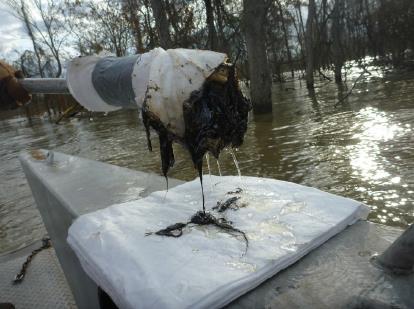
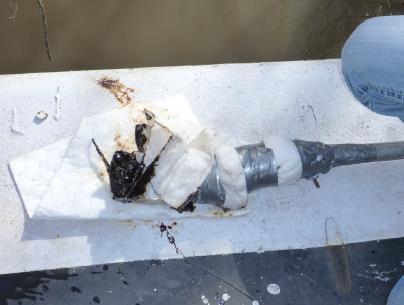
5 View: from starboard bow to port bow Front of the barge. Rake is collapsed and folded into the forward bulkhead.

6 Shoreline trees, now in River MM 46 Lightering Barge UTVs View: Overflight from stern to bow

7 Lightering Barge MM 46 View: from small boat to port bow

8 UTV Lightering Barge MM 46 View: from starboard bow to port bow

9 Response Resources: Response Equipment: 200 Feet Containment Boom 05 OSRO Vessels SCAT Resources: SCAT Assessments Conducted on 01 Feb, 03 Feb, 10 Feb, & 25 Feb Recovery conducted on 4-5 Feb & 11 Feb & 26 Feb Future Plans: Continue to conduct SCAT assessments & oil recovery as river level recedes and more shoreline is exposed; Gain Unified Command concurrence on completion of recovery when appropriate
10 River conditions affected ability to locate spilled CCFB -Different than APEX 3508 slurry oil spill near Paducah, KY Use of USACE Side Scan Sonar equipment Consultation with SHPO & USFWS


11 River Info 21 Jan 2016 Discharge near Natchez: 1.77 million cfs Based on cross-sectional area of river this represents an AVERAGE velocity of 4.6 knots Mid channel currents are likely stronger, on the order of 6 kts 24 Feb remains above normal

12 USACE Survey -River Bottom The gray line is a longitudinal profile from the multibeam starting near the bridge. The green line started near the bridge 2 hours later. The sand waves are moving from right to left, 30 feet tall and 600 feet long. The downstream face of the sand waves moved about 30 feet in 2 hours.

13 USACE Survey -River Bottom Velocity magnitude for feet of a longitudinal transect. The heavy black line at the bottom of the profile shows the sand waves on the channel bottom.


14 USACE Survey Multi-beam Imagery SCOUR HOLE AREA BUOY ANCHOR EDGE OF BARGE Area of Low Velocity near the barge in the 2 deep scour holes

15 USACE Survey Side Scan Sonar No anomalies noted.

16 USACE Survey River Velocities Longer arrows indicating faster velocity in center channel Shorter arrows indicating slower velocity along barge location

17 USACE Survey Info Coastal Hydraulic Laboratory (CHL) from US Army Engineer Research and Development Center (ERDC) 25 workboat: -Geoswath 250 khz interferometric sonar -600 khz RD Instruments Acoustic Doppler Current Profiler (ADCP)
18 USACE Survey Info Although side scan sonar did not identify areas with anomalies that could be investigated as sunken oil It was critical in characterizing river conditions to identify areas of potential sunken oil (scour areas and shoreline) to be targeted for further investigation and recovery. Was best tool for assessing bottom conditions; Confirmed significant bottom sediment transport and allowed UC to focus efforts on recovering oil from shoreline
 Q-Tip Sentinel Snare VSORS")
19 Vessel Submerged Oil Recovery System (VSORS) Q-Tip Sentinel Snare VSORS mapping


20 VSORS Sentinel Snare Q-Tip

21 VSORS Jan 24 & Jan 25 VSORS Results

22 How do we check for submerged oil after damaged barge has departed? What are the risks in this area?

23 This slide looks really complicated, but the takeaway is that if you have the right people at the response, you can mitigate risks and develop safe response options

24 VSORS- Bottom Sampling 25 Jan Green Non Detect, weighted sorbent snare Yellow Non Detect, weighted sorbent snare Red Detect using Q-tip

25 Consultation with MS State Historic Preservation Office (SHPO) rep (MS Dept of Archives & History) indicated possible resource concerns in the response area Consultation with USFWS Representatives from both were present during SCAT on 03 Feb and reported no particular resources at risk and no opposition to proposed response techniques NOAA SSC facilitated this process on behalf of USCG FOSC

26 Final Stages - SCAT
API Study on Detection and Recovery of Sunken Oil. API Study Objectives
 API Study on Detection and Recovery of Sunken Oil Jacqueline Michel, Research Planning, Inc. Mark Ploen, QualiTech Jim Elliott, T&T Marine Salvage, Inc. William Key API Study Objectives 1. ID current best
Point LaBarbe/McGulpin Point Response April 2 May 8, 2018 Regional Response Team 3 Meeting November, 2018
 Point LaBarbe/McGulpin Point Response April 2 May 8, 2018 Regional Response Team 3 Meeting November, 2018 TJ Mangoni District Response Advisory Team Supervisor Ninth Coast Guard District 216-214-4285 Summary
M/V SELENDANG AYU. Unalaska Island, Alaska
 M/V SELENDANG AYU Unalaska Island, Alaska December 2004 1 Characteristic Aleutians Response Foreign flag vessel on innocent passage Lack of spill response vessels Economically important fisheries Subsistence
Oil Spill Incident Annex. Introduction [Link to the Oil and Hazardous Materials Incident Annex in the NRP]
![Oil Spill Incident Annex. Introduction [Link to the Oil and Hazardous Materials Incident Annex in the NRP]](/thumbs/89/100738091.jpg "Oil Spill Incident Annex. Introduction [Link to the Oil and Hazardous Materials Incident Annex in the NRP]") Introduction [Link to the Oil and Hazardous Materials Incident Annex in the NRP] Response to oil spills can vary greatly, involving only a few people or thousands. The initial action taken by responders
Introduction [Link to the Oil and Hazardous Materials Incident Annex in the NRP] Response to oil spills can vary greatly, involving only a few people or thousands. The initial action taken by responders
High Definition Laser Scanning (HDS) Underwater Acoustic Imaging and Profiling
 Underwater Acoustic Imaging and Profiling") High Definition Laser Scanning (HDS) Underwater Acoustic Imaging and Profiling Images at Depth: The Use of Acoustic Imaging on Large River Crossings A Case Study AGENDA Background of project Review of
High Definition Laser Scanning (HDS) Underwater Acoustic Imaging and Profiling Images at Depth: The Use of Acoustic Imaging on Large River Crossings A Case Study AGENDA Background of project Review of
ARGO Incident. Marine Safety Unit Toledo, OH U.S. Coast Guard Sector Detroit, MI Ohio Environmental Protection Agency
 ARGO Incident Marine Safety Unit Toledo, OH U.S. Coast Guard Sector Detroit, MI Ohio Environmental Protection Agency ARGO Background: Built 1911, sunk in 1937 (78 yrs ago), 120ft x 35ft x 12ft with 4 to
National Transportation Safety Board
 Accident no. Vessel names Accident type Location DCA15LM034 National Transportation Safety Board Marine Accident Brief Collision between Dewey R Tow and P. B. Shah Tow Dewey R tow and P. B. Shah tow Collision
APPLICANT: Pacific Northwest National Laboratory Attention: Mr. Charles Brandt 1529 West Sequim Bay Road Sequim, Washington 98382
 US Army Corps of Engineers Seattle District Joint Public Notice Application for a Department of the Army Permit and a Washington Department of Ecology Water Quality Certification and/or Coastal Zone Management
Authors API Technical Report
 Sunken Oil Detection and Recovery API Technical Report Sunken Oil Detection and Recovery - Operational Guide Published February, 2016 Authors API Technical Report Jacqueline Michel, Research Planning,
Vieques Underwater Demonstration Project
 Vieques Underwater Demonstration Project NOAA Office of Response and Restoration National Ocean Service 2006-2007 2007 University of New Hampshire Joint Hydrographic Center 2006 Science Application International
U.S. Coast Guard Regulatory & Response Framework
 U.S. Regulatory & Response Framework U.S. Headquarters Office of Marine Environmental Response Policy 1 2 Oil Pollution Act of 1990 / FWPCA / Clean Water Act Vessel Response Plans 33 CFR Section 155 Waterfront
Western Canadian Spill Services Ltd. Field Testing Exercise Report
 Western Canadian Spill Services Ltd. Field Testing Exercise Report Wednesday, July 15, 2009 Clearwater River, Rocky Mountain House, AB Background Western Canadian Spill Services Ltd. (WCSS) held a field
Section Decanting Response Tool
 Section 9411 Decanting Response Tool T able of Contents Section Page 9411 Decanting Response Tool... 9411-1 9411.1 Introduction... 9411-1 9411.2 Decanting Policy... 9411-1 9411.2.1 Criteria... 9411-1 9411.2.2
Certified Professionals in Hydrographic Solutions
 Certified Professionals in Hydrographic Solutions Client Satisfaction is our Deliverable Port of Brisbane Pty Ltd Port Surveys Certified Professionals in Hydrographic Surveying Tel +61 (0) 7 3258 4820
Comments and Requests for Additional Information. Regarding
 Comments and Requests for Additional Information Regarding Furie Operations Alaska, LLC Cook Inlet Exploration Program Oil Discharge Prevention and Contingency Plan (12-CP-5184) Submitted By COOK INLET
Section Decanting Response Tool
 Section 9411 Decanting Response Tool T able of Contents Section Page 9411 Decanting Response Tool... 9411-1 9411.1 Introduction... 9411-1 9411.2 Decanting Policy... 9411-1 9411.2.1 Criteria... 9411-1 9411.2.2
Utilizing Vessel Based Mobile LiDAR & Bathymetry Survey Techniques for Survey of Four Southern California Breakwaters
 Utilizing Vessel Based Mobile LiDAR & Bathymetry Survey Techniques for Survey of Four Southern California Breakwaters Western Dredging Association: Pacific Chapter September 2012 Insert: Pipe Location
Chief-Planning & Readiness USCG Sector Houston-Galveston
 Boom Efficacy During the DEEPWATER HORIZON Response LCDR Joseph J. Leonard, Jr. Chief-Planning & Readiness USCG Sector Houston-Galveston June 2011 Boom Selection Responder Skill Sets Boom Utilization Site
S.S. MONTEBELLO Assessment Radiation Detection Case Study
 S.S. MONTEBELLO Assessment Radiation Detection Case Study Specifications Owner: Union Company of California Launched: San Pedro, CA - January 1921 Tonnage: 6010 (Underdeck) Dimensions: 440 ft (Registered)
PROPOSING A NEW PORTABLE DEVICE FOR BRIDGE SCOUR INSPECTION
 PROPOSING A NEW PORTABLE DEVICE FOR BRIDGE SCOUR INSPECTION KISEOK KWAK Senior Researcher, Geotech. Eng. Res. Dept., Korea Institute of Construction Technology, 2311 Daehwa-dong, Ilsan-gu, Koyang City,
Planning Considerations for Nearshore Placement of Mixed Dredged Sediments
 Planning Considerations for Nearshore Placement of Mixed Dredged Sediments PURPOSE: Dredging planning and management decisions are based on a combination of engineering and economic factors tempered by
1. At what speed must you throw a ball vertically in order to reach the top of a building, 12m tall? Vectors
 Physics R Date: 1. At what speed must you throw a ball vertically in order to reach the top of a building, 12m tall? Scalar: Vectors Vectors Scalars Vector: Wind is blowing 15 m/s East. What is the magnitude
Ohio Shipwreck Inventory Data Entry Instructions
 Ohio Shipwreck Inventory Data Entry Instructions VESSEL IDENTIFICATION 1. Vessel Name (required information): Name given to vessel by owner. If vessel name is unknown type Unknown in this field. 2. Name:
Implementation and Effect of Major Oil Recovery System Exercises
 Implementation and Effect of Major Oil Recovery System Exercises by Svein Edward Kjellsen Senior Executive Officer Norwegian Pollution Control Authority Commercial Services Unit Implementation and Effect
WCMRC Technical Manual. Waste Management Tactics
 WCMRC Technical Manual Waste Management Tactics this page left intentionally blank 74 P a g e WASTE MANAGEMENT TACTICS PURPOSE OF THE WASTE MANAGEMENT TACTICS This section covers waste management issues
Geographic Response Plan Map: EFL-25. Map Continued on Page: EFL-30. EFL25-01 Cape Canaveral Air Force Station Nesting Beach - South
 r. 80 37'30"W Banana River 28 30'0"N!d! White Geographic Response Plan Map: EFL-25 Point Map Continued on Page: EFL-30 80 30'0"W 28 30'0"N! Cactus Point a th)! er erve Map Continued on Page: EFL-26!S(!d
Physical Modeling of Nearshore Placed Dredged Material Rusty Permenter, Ernie Smith, Michael C. Mohr, Shanon Chader
 Physical Modeling of Nearshore Placed Dredged Material Rusty Permenter, Ernie Smith, Michael C. Mohr, Shanon Chader Research Hydraulic Engineer ERDC-Coastal Hydraulics Laboratory October 25,2012 Study
MOOS IvP Helm Based Simulations of Collision Avoidance by an Autonomous Surface Craft Performing Repeat-Transect Oceanographic Surveys
 MOOS IvP Helm Based Simulations of Collision Avoidance by an Autonomous Surface Craft Performing Repeat-Transect Oceanographic Surveys Michael A. Filimon Dept. of Ocean Engineering Daniel L. Codiga Grad.
NEED FOR SUPPLEMENTAL BATHYMETRIC SURVEY DATA COLLECTION
 305 West Grand Avenue, Suite 300 Montvale, New Jersey 07645 Phone 201.930.9890 Fax 201.930.9805 www.anchorqea.com M EMORANDUM To: Caroline Kwan and Nica Klaber U.S. Environmental Protection Agency Region
Project to Refine a Prototype Unmanned, Tethered ADCP Platform for Measuring Streamflow
 Pagina 1 di 5 Project to Refine a Prototype Unmanned, Tethered ADCP Platform for Measuring Streamflow The use of trade, firm, or product names is for descriptive purposes only and does not imply endorsement
Risk Reduction in Offshore Decommissioning Chevron s Success in the Gulf of Mexico
 Risk Reduction in Offshore Decommissioning Chevron s Success in the Gulf of Mexico Lew Dennis Decommissioning Manager Chevron Gulf of Mexico Business Unit 1 Key Messages Focusing on Risk Reduction in Decommissioning
Good Mooring to You! Jensen Beach Mooring Field. Kathy Fitzpatrick, P.E. Coastal Engineer, Martin County
 Good Mooring to You! Kathy Fitzpatrick, P.E. Coastal Engineer, Martin County Penny Cutt Regional Manager, Coastal Systems International Mooring Field Advantages Provide a safe and secure anchorage at a
NOAA s Underwater UXO Demonstration Projects Vieques Island, Puerto Rico
 NOAA s Underwater UXO Demonstration Projects Vieques Island, Puerto Rico Vieques Restoration Advisory Board Meeting May 7, 2008 Jason Rolfe NOAA s Office of Response & Restoration NOAA s Underwater UXO
Rules Practice Exam 14
 1 BOTH INTERNATIONAL & INLAND Additional light signals are provided in the Annexes to the Rules for vessels. A. engaged in fishing B. not under command C. engaged in towing D. under sail 2 BOTH INTERNATIONAL
Rules Practice Exam 5
 1 BOTH INTERNATIONAL & INLAND Vessel "A" (towing) and vessel "B" are meeting as shown. In this situation, which statement is TRUE? Diagram 12 A. Both vessels should alter course to starboard and pass port
Vectors. Wind is blowing 15 m/s East. What is the magnitude of the wind s velocity? What is the direction?
 Physics R Scalar: Vector: Vectors Date: Examples of scalars and vectors: Scalars Vectors Wind is blowing 15 m/s East. What is the magnitude of the wind s velocity? What is the direction? Magnitude: Direction:
Update on Canadian Research Vessels Ship Procurement Projects
 Update on Canadian Research Vessels Ship Procurement Projects 28 th International Research Ship Operators Meeting (IRSO) La Jolla, California October 2012 Jennifer Vollrath 1 Outline National Ship Building
Sensor Platform Project Marine Trials Bidders Conference. Fundy Ocean Research Center for Energy fundyforce.ca
 Sensor Platform Project Marine Trials Bidders Conference Fundy Ocean Research Center for Energy fundyforce.ca 1 Project Team FORCE OceanWorks International Preliminary Design, Operational Procedures Murray
Geographic Response Plan Map: SFL-21. Map continued on: SFL-31S XXX. k Curry Hammock. SFL21-05 Grassy Key Beaches. Map continued on: SFL-20
 ! 81 0'0"W Geographic Response Plan Map: SFL-21 Map continued on: SFL-31S 80 52'30"W Arse XXX S A 24 52'30"N j Everglades National Park [] [ 24 52'30"N Florida Bay Flo Nati S 9N-01 oo Banks ock 54! Bamboo
City of Port Aransas Shoreline Analysis and Improvements
 City of Port Aransas Shoreline Analysis and Improvements FINAL Technical Report August 24, 2016 Submitted To: City of Port Aransas Prepared for: City of Port Aransas This document is intended for planning
The 2010 BP Oil Disaster Pacific States Marine Fisheries Commission 63 rd Annual Meeting August 24, 2010
 The 2010 BP Oil Disaster Pacific States Marine Fisheries Commission 63 rd Annual Meeting August 24, 2010 Larry Simpson Gulf States Marine Fisheries Commission Oil Spill On April 20, 2010, the Deepwater
GLOSSARY. Contaminated Debris Disposal - the ability to directly dispose of contaminated material and/or contract for its disposal
 GLOSSARY Note: This Glossary is to be used in conjunction with the Response Functions Matrix. Except for marked items, "ability to provide" includes providing by contract. Air Modeling - provide computer
Offshore Wind Energy Stringent quality assurance and quality control. Coastal and Freshwater Fast responding and flexible organisation
 Services Oceanographic and Positioning Equipment Rental Meteorological and Oceanographic Surveys Data Analysis and Characterisation Marine Energy Resource Assessment Real-Time Monitoring Founded in 2010,
Potential applications of AUVs and Gliders in Offshore Windfarm Site Surveys
 Potential applications of AUVs and Gliders in Offshore Windfarm Site Surveys Dr James Hunt (National Oceanography Centre, Southampton) MREKE Internship in partnership with MARS at NOCS Introduction to
Exploring Localized Mixing Dynamics During Wet Weather in a Tidal Fresh Water System
 Exploring Localized Mixing Dynamics During Wet Weather in a Tidal Fresh Water System Ramona McCullough & Phil Duzinski Delaware Estuary Science & Environmental Summit January 27, 2015 Background and objectives
Coastal and Hydraulics Laboratory
 ERDC/CHL TR-08-14 Navigation Systems Research Program Detection and Evaluation of Scour Protection for Navigation Dams John E. Hite, Jr. August 2008 Coastal and Hydraulics Laboratory Approved for public
MARINE INCIDENT SUMMIT INCIDENT BRIEFS FROM THE 2ND & 3RD QUARTERS OF CY 2014
 MARINE INCIDENT SUMMIT INCIDENT BRIEFS FROM THE 2ND & 3RD QUARTERS OF CY 2014 MARINE SAFETY UNIT PITTSBURGH Office: (412) 644-5808 Fax (412) 644-3479 Pittsburgh2692@uscg.mil Disclaimer: This document is
Evaluation of Placement Alternatives for Matagorda Ship Channel Bottleneck Removal
 Evaluation of Placement Alternatives for Matagorda Ship Channel Bottleneck Removal James Rosati III Ashley E. Frey CPT Grays Harbor, WA Wood Wood chips Flour Other CMS Shark River Inlet, NJ US Army Corps
STATUS REPORT FOR THE SUBMERGED REEF BALL TM ARTIFICIAL REEF SUBMERGED BREAKWATER BEACH STABILIZATION PROJECT FOR THE GRAND CAYMAN MARRIOTT HOTEL
 August 23 STATUS REPORT FOR THE SUBMERGED REEF BALL TM ARTIFICIAL REEF SUBMERGED BREAKWATER BEACH STABILIZATION PROJECT FOR THE GRAND CAYMAN MARRIOTT HOTEL performed by Lee E. Harris, Ph.D., P.E. Consulting
Standard Operating Procedure
 Standard Operating Procedure BOOMS Offshore RO-BOOM / Lamor HD boom Equipment description SOP intended for the use and deployment of Lamor HD 1300 and Desmi Ro-clean 1500 offshore boom. The boom reel holds
River. Dynamics Canoeing: This section focuses on rivers; how they flow and on some basic maneuvers which you can execute on the river.
 This section focuses on rivers; how they flow and on some basic maneuvers which you can execute on the river. Dynamics Canoeing: By Robert B. Kauffman, Ph.D. 1 Topics - Laminar and shore to center flows
Marine Kit 4 Marine Kit 4 Sail Smooth, Sail Safe
 Marine Kit 4 Marine Kit 4 Sail Smooth, Sail Safe Includes Basic ship Terminologies and Investigation Check list Index 1. Ship Terminology 03 2. Motions of a Floating Body...09 3. Ship Stability.10 4. Free
GOZO COLLEGE. Half Yearly Examinations for Secondary Schools FORM 4 PHYSICS TIME: 1h 30min
 GOZO COLLEGE Track 3 Half Yearly Examinations for Secondary Schools 2016 FORM 4 PHYSICS TIME: 1h 30min Name: Class: Answer all questions. All working must be shown. The use of a calculator is allowed.
EXAMINATION OF AE WAVE PROPAGATION ROUTES IN A SMALL MODEL TANK
 EXAMINATION OF AE WAVE PROPAGATION ROUTES IN A SMALL MODEL TANK HIDEYUKI NAKAMURA 1, TAKAHIRO ARAKAWA 2, MINORU YAMADA 3 1) System Divisions, Ishikawajima Inspection & Instrumentation Co., 1720 Kamai,
BEFORE THE ENVIRONMENTAL PROTECTION AUTHORITY JOINT STATEMENT OF EXPERTS IN THE FIELD OF MARINE MAMMALS
 BEFORE THE ENVIRONMENTAL PROTECTION AUTHORITY IN THE MATTER of the Exclusive Economic Zone and Continental Shelf (Environmental Effects) Act 2012 AND IN THE MATTER of an Application for Marine D u m p
This training is intended to be educational and should not be construed as legal guidance. It is provided as a courtesy to our customers and others
 June 2012 This training is intended to be educational and should not be construed as legal guidance. It is provided as a courtesy to our customers and others who may benefit from the information contained
Suez Canal grounding with pilot onboard
 August 2016 Suez Canal grounding with pilot onboard The oil tanker was transiting the Suez Canal and had loaded crude oil in North Africa, and was on its way to India. On the bridge were the pilot, master,
Plot the Path into the Harbor
 Plot the Path into the Harbor By Mary Anne Otten, Rudyard Area Schools and Joan Chadde, Michigan Technological University Subject/Grade: Grade 3 6, Math, Social Studies, Science Duration: 35 minutes Lesson
DALE HOLLOW LAKE TROOPER ISLAND IMPROVEMENT PROJECT Proposal for Reservoir Fisheries Habitat Partnership (RFHP)
") DALE HOLLOW LAKE TROOPER ISLAND IMPROVEMENT PROJECT Proposal for Reservoir Fisheries Habitat Partnership (RFHP) A. Applicant Information: US Army Corps of Engineers, Dale Hollow Lake POC: Gregg Nivens
DALE HOLLOW LAKE TROOPER ISLAND IMPROVEMENT PROJECT Proposal for Reservoir Fisheries Habitat Partnership (RFHP) A. Applicant Information: US Army Corps of Engineers, Dale Hollow Lake POC: Gregg Nivens
Use of Conservation Moorings as a Component of Eelgrass Restoration in two Massachusetts Harbors
 Use of Conservation Moorings as a Component of Eelgrass Restoration in two Massachusetts Harbors Massachusetts Bays Program Division of Marine Fisheries Jay Baker, Tay Evans, Mass Bays Program MarineFisheries
2005 ABC. Chapter 3 Part 2. Navigating with ATON's. Revision to D-13 Local Notes. Instructor Notes for Mike Brough. Mike Brough
 2005 ABC Chapter 3 Part 2 Navigating with ATON's Revision to D-13 Local Notes Instructor Notes for Mike Brough Mike Brough June 24 2008 June 24 2008 Slide 1 June 24 2008 New graphics Navigating on Water
The 2017 Panama City Beaches Beach Interim Renourishment Project. Answers to Common Questions
 The 2017 Panama City Beaches Beach Interim Renourishment Project The fourth renourishment of the Panama City Beaches will be under construction during March and April 2017, with a planned completion by
TRANSPORT OF NEARSHORE DREDGE MATERIAL BERMS
 Proceedings of the 6 th International Conference on the Application of Physical Modelling in Coastal and Port Engineering and Science (Coastlab16) Ottawa, Canada, May 10-13, 2016 Copyright : Creative Commons
REGION 2. Eysturoy (north)
") REGION 2. Eysturoy (north) DATE OF SURVEY: October 2000 General Description of the Area including Tidal Information The region consists of the northern part of Eysturoy, within which are the coastal villages
REGION 2. Eysturoy (north) DATE OF SURVEY: October 2000 General Description of the Area including Tidal Information The region consists of the northern part of Eysturoy, within which are the coastal villages
Fowey Harbour Commissioners Appendix Page 106 APPENDICES
 Fowey Harbour Commissioners Appendix Page 106 APPENDICES Fowey Harbour Commissioners Appendix Page 107 Contents Appendix 1 Adler & Allan Limited Contents Adler & Allan Limited Accreditation Certificate...
SeaSmart. Jonathan Evans
 SeaSmart A new approach for rapid, on-site resource assessment at potential tidal stream energy array sites using MAS Marine Solutions for the Deep Data World Jonathan Evans Presentation Outline Marine
Dredging Keeping Our Underwater Highways Open
 Dredging Keeping Our Underwater Highways Open Sedimentation Material that falls to the bottom of a liquid is called sediment. If enough sediment deposits to build a shallow spot on the river or ocean bottom,
SUMMARY OF MOVEMENT AND HABITAT USED BY TAGGED BROOK TROUT IN THE MAIN BRANCH AND NORTH BRANCH AU SABLE RIVER DURING SUMMER Data Submitted to:
 SUMMARY OF MOVEMENT AND HABITAT USED BY TAGGED BROOK TROUT IN THE MAIN BRANCH AND NORTH BRANCH AU SABLE RIVER DURING SUMMER 2014 Data Submitted to: Anglers of the Au Sable Submitted by: Dr. Mark R. Luttenton
Assateague Island National Seashore North End Restoration Project Timeline
 Assateague Island National Seashore North End Restoration Project Timeline Date Event Some information provided in the Project Introduction document. Detailed events are available in a timeline compiled
Rules Practice Exam 12
 1 INLAND ONLY You are on vessel "A", and vessel "B" desires to overtake you on your starboard side as shown. After the vessels have exchanged one blast signals, you should. Diagram 31 A. alter course to
The Basics of Victory Sailing II
 The Basics of Victory Sailing II Torrey Pines Sailing Club Sailing from Island Palms Marina on Shelter Island San Diego, CA Visit us at our web site 1 Boating Safety Safety First Life jacket Suntan lotion
Developing a. Guidance for operators who need to develop a. specified limits plan
 Developing a specified limits plan Guidance for operators who need to develop a specified limits plan Developing a specified limits plan Last updated: 10 November 2014 In this guide 1. Overview 2 1.1 Specified
MARINE NAVIGATION LESSON PLAN See That Sound?
 Marine Navigation Hydrography Lesson Plan MARINE NAVIGATION LESSON PLAN See That Sound? Theme Hydrographic Survey Links to Overview Essays and Resources Needed for Student Research http://oceanservice.noaa.gov/topics/navops/hydrosurvey/
Understanding the Tsunami Wave
 The First Tsunami attack on Sri Lanka Krakatoa Island 27 th August 1883 Understanding the Tsunami Wave Generation Propagation Nearshore Transformation Shoreline Entry Inland Dissipation 1 Generation and
Sontek RiverSurveyor Test Plan Prepared by David S. Mueller, OSW February 20, 2004
 Sontek RiverSurveyor Test Plan Prepared by David S. Mueller, OSW February 20, 2004 INTRODUCTION Sontek/YSI has introduced new firmware and software for their RiverSurveyor product line. Firmware changes
York River Marine Debris Survey (Off-season)
") York River Marine Debris Survey- Marine Debris Removal Jan/Feb 2006 (Off-season) Kirk Havens David Stanhope Kory Angstadt Center for Coastal Resources Management Virginia Institute of Marine Science Sarah
York River Marine Debris Survey- Marine Debris Removal Jan/Feb 2006 (Off-season) Kirk Havens David Stanhope Kory Angstadt Center for Coastal Resources Management Virginia Institute of Marine Science Sarah
Plot the Path. Mary Anne Otten. lesson three
 Plot the Path Mary Anne Otten lesson three Subject/Grade: Grade 2, Math, Social Studies, Science Duration: one class period Materials needed: Per class: Day the Great Lakes Drained Away by Charles Ferguson
Cook Inlet pipeline crossing is about making the best choices
 Cook Inlet pipeline crossing is about making the best choices By Larry Persily lpersily@kpb.us Aug. 26, 2015 (This update, provided by the Kenai Peninsula Borough mayor s office, is part of an ongoing
INVESTIGATING STRATEGIES TO REPAIR HISTORIC TIDE WALLS ON THE CLARENCE RIVER AND ADJACENT BEACH AND RIVER BANK PROTECTION
 INVESTIGATING STRATEGIES TO REPAIR HISTORIC TIDE WALLS ON THE CLARENCE RIVER AND ADJACENT BEACH AND RIVER BANK PROTECTION I Jayewardene 1, A Hartley 2, B Blumberg 1, E Couriel 1 1 NSW Water Solutions,
Undertow - Zonation of Flow in Broken Wave Bores
 Nearshore Circulation Undertow and Rip Cells Undertow - Zonation of Flow in Broken Wave Bores In the wave breaking process, the landward transfer of water, associated with bore and surface roller decay
National Maritime Center
 National Maritime Center Providing Credentials to Mariners U.S.C.G. Merchant Marine Exam (Sample Examination) Page 1 of 22 U.S.C.G. Merchant Marine Exam: Illustrations: 10 Choose the best answer to the
Rules Practice Exam 11
 1 BOTH INTERNATIONAL & INLAND While underway in fog, you hear a vessel sound one prolonged blast followed by two short blasts on the whistle. What does this signal indicate? A. A vessel towing B. A vessel
Geographic Response Plan Map: SFL-25. Map continued on: SFL-29. Lignumvitae Key. Aquatic Preserve. Lignumvitae Key Botanical.
 ! 25 0'0"N 80 45'0"W Spy Key Geographic Response Plan Map: SFL-25 Panhandle Key Panhandle Key Florida Bay Map continued on: SFL-29 Crab Keys West Key 80 37'30"W 25 0'0"N Crane Keys Crane Keys XXX j Everglades
Rules of the Road. in Chichester Harbour Avoiding collisions and navigating safely
 Rules of the Road in Chichester Harbour Avoiding collisions and navigating safely 04 50 www.conservancy.co.uk Introduction All boats using the Harbour are subject to the International Rules for Preventing
Constant Acceleration: The physics of sailing
 Constant Acceleration: The physics of sailing Sailing gives examples of physics: Newton's laws, vector subtraction, Archimedes' principle and others. This support page from Physclips asks How can a boat
Waves, Bubbles, Noise, and Underwater Communications
 Waves, Bubbles, Noise, and Underwater Communications Grant B. Deane Marine Physical Laboratory, Scripps Institution of Oceanography UCSD, La Jolla, CA 92093-0238 phone: (858) 534-0536 fax: (858) 534-7641
Advantages of Using Combined Bathymetry and Side Scan Data in Survey Processing T.M. Hiller, L.N. Brisson
 Advantages of Using Combined Bathymetry and Side Scan Data in Survey Processing T.M. Hiller, L.N. Brisson EdgeTech, West WareHam MA, USA EdgeTech 6205 Combined Bathymetric and Side Scan Sonar EdgeTech
Cruise Report. Field Oceanography. Team 5, Leg 3
 Cruise Report Field Oceanography Team 5, Leg 3 Submitted by: Lina Stolze Allison Kennedy Madlena Hukobyan Peter Hülse Date: October 27, 2008 1. Objectives The fieldwork was part of a field oceanography
Coastal and Hydraulics Laboratory
 ERDC/CHL TR-11-2 Coastal Inlets Research Program Analysis of Dredged Material Placement Alternatives for Bottleneck Removal, Matagorda Ship Channel, Texas James Rosati III, Ashley E. Frey, Mitchell E.
CEPA Initiative: Response Time Guideline 2015 EMERGENCY SECURITY MANAGEMENT WORK GROUP
 CEPA Initiative: Response Time Guideline 2015 EMERGENCY SECURITY MANAGEMENT WORK GROUP Response Time Guideline aboutpipelines.com 1 of 8 Contents Table of Contents 1.0 Background 3 Purpose 3 Scope 3 Definitions
Charleston Area Contingency Plan January 2011 REVISION
 Charleston Area Contingency Plan January 2011 REVISION Prepared by the Charleston Area Committee Approval Letter Letter of Transmittal 1 Annexes Port of Charleston Marine Firefighting Plan Port of Charleston
MAPCO2 Buoy Metadata Report Project Title:
 MAPCO2 Buoy Metadata Report Project Title: Autonomous Multi-parameter Measurements from a Drifting Buoy During the SO GasEx Experiment Funding Agency: NOAA Global Carbon Cycle program PI(s): Christopher
US Sailing Presents. Around the Course
 /0/8 US Sailing Presents RRS Part : Around the Race Course with the Racing Rules of Sailing Presented by US Sailing Judges Committee (v 5 January, 08) 08 US Sailing All rights reserved. Around the Course
GEM Network; Færoe Islands Coastal Protection Plans. REGION 1. Viðoy. DATE OF SURVEY: October 2000
 REGION 1. Viðoy DATE OF SURVEY: October 2000 General Description of the Area including Tidal Information This region consists of the northern parts of Borðoy, Kalsoy, Kunoy, Svínoy as well as Fugloy. Borðoy
Monitoring Morphology and Currents at the Hatteras Breach
 Monitoring Morphology and Currents at the Hatteras Breach By Ty V. Wamsley U.S. Army Engineering Research and Development Center Coastal and Hydraulics Laboratory 3909 Halls Ferry Road, Vicksburg, MS 39180
Site-Specific Assessment of Jack-Ups Part 5: When Things Go Wrong Lessons and Mitigations
 OIL & GAS Site-Specific Assessment of Jack-Ups Part 5: When Things Go Wrong Lessons and Mitigations Noble Denton marine services Mike White 1 SAFER, SMARTER, GREENER Overview Review of several incidents:
VIDEO TRANSCRIPT. A Proposal to Expand the Flower Garden Banks National Marine Sanctuary An interview with Sanctuary Superintendent, G.P.
 VIDEO TRANSCRIPT A Proposal to Expand the Flower Garden Banks National Marine Sanctuary An interview with Sanctuary Superintendent, G.P. Schmahl (Opening scene of Flower Garden Banks National Marine Sanctuary
15 GRC AS AN ALTERNATIVE MATERIAL FOR LOW-COST, HIGH-DURABILITY FISHING BOATS
 15 GRC AS AN ALTERNATIVE MATERIAL FOR LOW-COST, HIGH-DURABILITY FISHING BOATS H. W. ASHADI, Material Laboratory, Civil Engineering Dept, University of Indonesia B. SOERYONUGROHO, PT KRAZU Musantara, Indonesia
An Integrated Marine Gradiometer Array System (MGA)
") An Integrated Marine Gradiometer Array System (MGA) For Detection and Location of Chemical and Conventional UXO/MEC in Shallow to Deep Marine and Freshwater Environments Introduction Tetra Tech EC, Inc.
An Integrated Marine Gradiometer Array System (MGA) For Detection and Location of Chemical and Conventional UXO/MEC in Shallow to Deep Marine and Freshwater Environments Introduction Tetra Tech EC, Inc.
Large-scale Field Test
 Vaskinn 1 Large-scale Field Test Kjetil Arne Vaskinn kav@trh.statkraftgroner.no Statkraft Grøner AS SUMMARY The objective the controlled failure of large-scale embankment is to monitor and record the failure