Design and Construction of Living
|
|
|
- Philomena Goodwin
- 5 years ago
- Views:
Transcription
1 Design and Construction of Living Shorelines A course for living shorelines professionals September 29, 2010 This course made possible by a grant from the Virginia Coastal Zone Management Program NOAA
2 Course Outline Part 1 Background Site Evaluation Process Selecting a Strategy Part 2 Lessons Learned from Case Studies Part 3 Work Through Design Examples


3 Course Instructors C. Scott Hardaway, Jr. Karen A. Duhring VIMS since 1979 Shorelines Studies Program Director Expert in headland breakwater systems Research projects along Chesapeake Bay and ocean shorelines of Virginia and Maryland VIMS since 1999 Center for Coastal Resources Management (CCRM) Scientist III Tidal shoreline advisory program, living shorelines, cumulative wetland impacts M.S. Geology, East Carolina University 1979 B.A. Geology, East Carolina University 1973 M.S. Coastal Zone Mgmt, FL Institute of Tech B.A. Environmental Studies, New College 1986
4 Who Are You? What is your name? What kind of living shorelines work do you do? Tell us one living shorelines design Tell us one living shorelines design challenge you are faced with
5 Why are we all here today? CZM contracted with VIMS to prepare design manual and teach a class Improve understanding of performance and design standards Shoreline management plans with LS targeting Regulatory programs now treat living shorelines as preferred methods Growing interest in general permits, other streamlining for living shorelines Educated professionals are needed to facilitate public interest review of how appropriate living shorelines are
6 Not Course Objectives Cover all living shoreline methods Solve all design challenges in 1 class Review the entire permit process VIMS endorsements
7 Part 1 Follows outline of Living Shorelines Design Manual Living Shorelines Principles Chesapeake Bay Shorelines Site Evaluation Process Selecting Strategy Level of protection / design storms Encroachment and habitat tradeoffs
8 Living Shorelines Principles Shore protection Solving erosion problems Least impacting, necessary method Sustaining i ecosystem services Water quality Storm protection Habitat Integrated Shoreline Management Riparian Buffer + Tidal Wetlands + Shallow Water Habitat = Combined Protection Benefits
9 Chesapeake Bay Shorelines Physical Setting How a shore reach has evolved helps determine management options Scarps and terraces Determine high and low banks Flooding frequency Erosion trends
10 Lands west of Suffolk Scarp are generally high with infrequent flooding Lands east of Suffolk Scarp are generally low with extensive marshes
11 Chesapeake Bay Shorelines Sea Level Rise Relative Sea Level Rise sea level rise + land subsidence Variable rates in mid-atlantic Accelerated e rates are predicted with uncertainty
12 Wave climate Chesapeake Bay Shorelines Hydrodynamic d Setting Wind influenced everywhere Ocean influence in lower Bay year-round Fetch determines wave energy potential Very low <0.5 mile Low mile Medium 1-5 miles High 5-15 miles Very high >15 miles Wind direction Tide range Mean Great diurnal or spring Storm water levels Relative sea level rise
13 SITE EVALUATION PROCESS
14 Site Evaluation Process Each shoreline professional has a method for conducting site evaluations A standardized data collection process is recommended Not all parameters have equal weight, professional judgment necessary Appendix A is a site evaluation worksheet
15 Site Evaluation Desktop or Map Parameters Existing information available from maps or Internet resources Not readily visible or measurable at ground level Site Visit Parameters Site-specific characteristics Local setting Not easily captured by remote sensing
16 Desktop or Map Parameters Shoreline orientation Fetch Shore Morphology Depth Offshore Nearshore Morphology Submerged Aquatic Vegetation (SAV) Tide Range Storm Surge Erosion Rate Design Wave
17 Shoreline Orientation Rule of thumb, not always a determining factor Good lighting Poor lighting South North


18 Measure Fetch Distances Longest Fetch black lines Average Fetch measure 5 green arrow vectors and take an average


19 Shore Morphology Pocket or embayed shorelines tend to cause waves to diverge and spread wave energy out Straight and headland shorelines receive the full impact of the wave climate Irregular shorelines tend to break up wave crests
20 Broad shallow nearshore has different wave attenuation than narrow deep water with same fetch Depth Offshore distance to 6 ft or 2m contour 6 ft contour lines NOAA Reduced Scale Navigational Charts


21 Nearshore Morphology Presence or absence of nearshore tidal flats and sand bars indicate sand supply, bottom conditions Important consideration for sills and breakwaters Hard supportive substrate vs. soft, fine-grained sediment
22 Submerged Aquatic Vegetation (SAV) Shallow sand flat with Submerged Aquatic Vegetation SAV
23 Submerged Aquatic Vegetation Quick Check CCRM Shoreline Assessment Mapper Previous 10 yrs SAV combined into 1 polygon


24 Submerged Aquatic Vegetation - Details Check VIMS SAV Inventory and Monitoring Interactive Map
25 Tide Range NOAA Tides and Currents benchmarks Variable by region Mean tide range and spring tide range Reference to tidal datum NAVD88 Critical information o for planted marshes


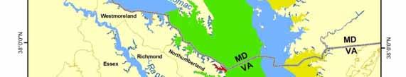
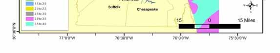
26 Mean Tide Ranges in feet Polygons interpolated t from NOAA data points Figure 1-3, pp. 46


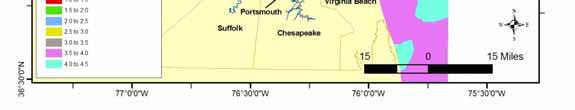
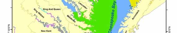
27 Spring Tide or Great Diurnal Tide Ranges in feet Figure 1-4, pp. 47
28 Storm Surge Predicted water level during certain storms Return frequencies probability of repeating 100-yr storm = 1% chance 50-yr storm = 2% chance 25-yr storm = 4% chance water level e will occur in any given year FEMA Flood Insurance Studies web site Look in Product Catalog
29 Erosion or Shoreline Change Rate Shoreline Studies Program Evolution Reports Northumberland Co. Lancaster Co. Westmoreland Co. Middlesex Co. Gloucester Co. Mathews Co. Newport News Poquoson York Co. Hampton Norfolk VA Beach Accomack County Northampton County Go To
30 Example from Shoreline Evolution Report for Gloucester Point
31 Design Wave Significant wave heights are the average of the highest 33% of the wind/wave field Wave heights for the highest 10% should be noted to determine rock size Predicted waves may be more or less than actual storm wave Many sophisticated wave prediction models can be used Simple method uses forecasting curves
32 Design Wave Forecasting Curves Source: U.S. Army Corps of Engineers (1977)


33 Site boundaries Site characteristics RPA Buffer Bank condition Bank height Bank composition Site Visit Parameters Shore zone width and elevation Backshore zone width and elevation Existing shoreline defense structures Nearshore stability Boat wake potential
34 Site Boundaries Legal property limits Determines where end effects and downdrift impacts should be considered Construction access options revealed Site Characteristics Current and future upland land use Locate visible and invisible improvements Primary and accessory structures Underground utilities Drainfields Groundwater wells Presence or absence of improvements determines level of protection needed


35 Bank Condition A A stable base of bank and bank face that has been graded and planted with vegetation. James River, Virginia A B B An unstable base of bank and bank face. The different colored layers indicates different types of material. Piankatank River, Virginia C C An undercut bank on the East River, Virginia.
36 Bank Height & Composition Upper bank Base of bank


37 Bank Vegetation Cover Resource Protection Area Buffer Densely Vegetated / Forested Previously Cleared Does vegetation ti cover contribute t to erosion protection ti or problem? Should the bank be graded or not? Is the absence of vegetation due to active erosion or previous land disturbance?
38 Combined Shore and Backshore Zone Width and Elevation
39 Shore Zone Width and Elevation Existing tidal wetland Non-vegetated Salt or freshwater marsh Cypress trees Existing sand beach Intertidal beach Combination Patchy marsh headlands with pocket beaches Measure width of each feature in profile Identify plant species, jurisdictional limits Do existing beach and marsh contribute to erosion protection? Can they be temporarily disturbed or enhanced?
40 Backshore Zone Width and Elevation Existing high marsh Saltmeadow hay Phragmites Measure width of each feature in profile Salt bushes Identify plant species, Existing supratidal jurisdictional limits beach > MHW Overwash sand Primary & secondary dune features Backshore terrace Bank slumping Upland grasses and trees Do existing features contribute to erosion protection? Can they be temporarily disturbed or enhanced?


41 Nearshore Stability Highly suitable for sill or breakwater Not suitable Important consideration for sills and breakwaters Firm vs. soft
 Presence or absence of docks, marinas, marked channels Local knowledge and judgment calls are required to weigh this")
42 Boat Wakes Boat wake effects are difficult to determine or predict High boat traffic in narrow waterways will produce severe wave climate not indicated by other parameters (fetch) Presence or absence of docks, marinas, marked channels Local knowledge and judgment calls are required to weigh this parameter
43 Existing Shoreline Defense Structures Target Shoreline Serviceable or failing Contributing to erosion protection or problem? Failed structures indicate wave climate, other design alternatives Adjacent Shoreline Consider effects on structural integrity Opportunities for reach-based solutions?
44 Coastal Profile Combine all parameters for site-specific conditions Are all parameters weighed equally? Consider how integrated habitats can influence shore protection, water quality and habitat functions Each element in the system works to reduce wave energy impacting the upland
45 Coastal profile examples
46 SELECTING A STRATEGY


47 First consider if any action is needed, d can minor erosion be tolerated? Selecting a Strategy If No Action is not acceptable, what is the least impacting solution to solve the particular erosion problem?


48 CCRM Decision Tree for Undefended Shorelines Suggested strategies in red Judgment calls required if site doesn t fit perfectly Does not account for all Does not account for all parameters in a weighted fashion


49 Marsh Planting and Management Non-structural approach Very low fetch <0.5 mile Planting at grade or into sand fill Fiber logs Tree pruning If marsh will not persist without fiber logs, then consider marsh sill


50 Stone revetment placed near MLW Backfilled with sand Planted with tidal wetland vegetation Marsh Sill Stone Sand Plants All 3 elements usually required for sustainable design


51 Marsh Toe Revetment Sill placed next to an existing wide marsh Maintain desirable marsh ecosystem services Natural accretion depends on local sediment supply Can also spot fill and plant to fill in non- vegetated areas


52 Why Tidal Openings? Marsh Sills and Marsh Toe Revetments Mitigate sill impacts on shallow water marsh edge interactions Tidal inundation and positive drainage for healthy plant growth Tightly packed stone in gabions restricts ti t water movementthroughh stones Marsh access for fish, crabs, terrapins g, g Algae bloom in warmer, stagnant area


53 Tidal Openings When should they be included? Site-specific Tidal ponds Natural or created channels Open ends Recreation access Sill crest height > MHW Sill length > 100 Ft No definitive standard May need more or less Tidal openings allow access for marine wildlife, but they also introduce wave energy into the planted marsh. Stable embayments eventually form


54 Tidal Openings Design Challenges Mb Gb More research is needed to confirm a design standard for predicting embayment position Minimize sand loss, planted marsh failure at gaps How to predict stable embayment position? Use similar ratio as breakwaters??? Maximum Bay Indentation : Gap Width Mb:Gb 1:1.65


55 Tidal Openings Design Challenges Sand deposits at pocket beach may restrict tidal inundation into and out of marsh Not always detrimental to marsh or access, depends on other parameters


56 Tidal Openings Other Design Types Weir Opening or Vented Sill Gap covered with stone at lower elevation Sediment deposition still evident Straight gap with cobblestone Reduces sand deposits How is biological activity altered?


57 Tidal Openings Other Design Types Gapped offset sections at pocket marsh Taper ends toward wave energy


58 Offshore Breakwaters Most appropriate p for high energy sand beach sites Create stable pocket beaches between fixed headlands At least 2 units Proper design requires advanced knowledge of coastal processes at site
59 Breakwater Design Guidelines Maximum Bay Indentation : Gap Width Mb:Gb 1:1.65 Crest Length : Gap Width Lb:Gb 1:1.4
60 Level of Protection and Design Storms Maximum wind-wave climate expected Amount of risk or damage property owner is willing to accept Balanced with cost- effectiveness Design storms 10 yr 25 yr 50 yr 100 yr Set elevations against eroding upland bank
61 Encroachment / Habitat Tradeoffs Landward Bank grading Tree removal Upland conversion to tidal wetlands Channelward Non-vegetated to vegetated tidal wetland Shallow water conversion to stone and vegetated marsh Submerged Aquatic Vegetation Sand movement & navigation channels Shellfish lease areas
62 Encroachment / Habitat Tradeoffs Which type is more common? Landward or channelward
63 Encroachment / Habitat Tradeoffs Which type is more common? Landward or channelward Which conversion typically has the most impact? Upland to wetland Non-vegetated to vegetated wetland Shallow water to vegetated wetland
64 End of Part 1
VIMS CCRM Coastal Management Decision Tools. Decision Tree for Undefended Shorelines and Those with Failed Structures
 VIMS CCRM Coastal Management Decision Tools Decision Tree for Undefended Shorelines and Those with Failed Structures Center for Coastal Resources Management Virginia Institute of Marine Science Gloucester
For more information or permission to reprint slides, please contact Donna Milligan at 1
 For more information or permission to reprint slides, please contact Donna Milligan at milligan@vims.edu 1 For more information or permission to reprint slides, please contact Donna Milligan at milligan@vims.edu
Living Shoreline Design Guidelines for Shore Protection in Virginia s Estuarine Environments
 Living Shoreline Design Guidelines for Shore Protection in Virginia s Estuarine Environments Virginia Institute of Marine Science College of William & Mary Gloucester Point, Virginia September 2010 Living
Design Considerations for Living Shorelines in Connecticut. Jennifer E.D. O Donnell Department of Marine Sciences University of Connecticut
 Design Considerations for Living Shorelines in Connecticut Jennifer E.D. O Donnell Department of Marine Sciences University of Connecticut October 2015 1 Contents Contents... 2 1 Why Living Shorelines?...
ALTERNATIVES FOR COASTAL STORM DAMAGE MITIGATION AND FUNCTIONAL DESIGN OF COASTAL STRUCTURES
 The University of the West Indies Organization of American States PROFESSIONAL DEVELOPMENT PROGRAMME: COASTAL INFRASTRUCTURE DESIGN, CONSTRUCTION AND MAINTENANCE A COURSE IN COASTAL DEFENSE SYSTEMS I CHAPTER
Estuarine Shoreline Stabilization
 Estuarine Shoreline Stabilization Property Owner s Guide to Determining the Most Appropriate Stabilization Method Estuarine shorelines are dynamic features that experience continued erosion. Land is lost
ALTERNATIVES FOR COASTAL STORM DAMAGE MITIGATION
 ALTERNATIVES FOR COASTAL STORM DAMAGE MITIGATION Dave Basco Old Dominion University, Norfolk, Virginia, USA National Park Service Photo STRUCTURAL (changes to natural, physical system) hardening (seawalls,
Shoreline Studies Program, Department of Physical Sciences, VIMS
 Living Shoreline Training Class 2017 1 Demonstration sites discussed in this talk. 2 A shoreline management plan for the entire creek made conceptual shoreline management recommendations along every stretch
Shore Zone Management Planning for Middle Peninsula Chesapeake Bay Public Access Authority Properties
 College of William and Mary W&M ScholarWorks Reports 3-2017 Shore Zone Management Planning for Middle Peninsula Chesapeake Bay Public Access Authority Properties Donna Milligan Virginia Institute of Marine
Dune Monitoring Data Update Summary: 2013
 Dune Monitoring Data Update Summary: 13 Shoreline Studies Program Virginia Institute of Marine Science College of William & Mary Gloucester Point, Virginia September 13 Dune Monitoring Data Update Summary:
Living Shoreline Design Guidelines for Shore Protection in Virginia s Estuarine Environments
 College of William and Mary W&M ScholarWorks Reports 9-2017 Living Shoreline Design Guidelines for Shore Protection in Virginia s Estuarine Environments C. Scott Hardaway Jr Virginia Institute of Marine
City of Suffolk Shoreline Management Plan
 College of William and Mary W&M Publish Reports 4-2014 City of Suffolk Shoreline Management Plan C. Scott Hardaway Jr. Virginia Institute of Marine Science Donna A. Milligan Virginia Institute of Marine
GONE! Coastal Erosion Happens During Storms! Why Worry About Coastal Setbacks? Goals for Today
 RI Regulatory Setbacks & Buffers: Coastal Zone Management Issues New England Onsite Wastewater Training Program @ URI OWT 155 November 21, 2013 Goals for Today Understand the impacts of storms, coastal
RI Regulatory Setbacks & Buffers: Coastal Management Issues
 RI Regulatory Setbacks & Buffers: Coastal Management Issues New England Onsite Wastewater Training Program @ URI OWT 155 - November 29, 2012 James Boyd - Coastal Policy Analyst Photo: October 30, 2012
Fairfax County Shoreline Management Plan
 Fairfax County Shoreline Management Plan Prepared for Fairfax County and Virginia Coastal Zone Management Program Virginia Institute of Marine Science College of William & Mary Gloucester Point, Virginia
Figure 1. Schematic illustration of the major environments on Mustang Island.
 STOP #1: PACKERY CHANNEL BEACH TO BAY We will start this field guide near the north jetty of Packery Channel and hike across the island to Corpus Christi Bay (fig. 1). The island emerges from the Gulf
Brief History of Headland Breakwaters Usage in Chesapeake Bay, USA. 25 Years of Rock, Sand and Plants for Shore Protection
 Brief History of Headland Breakwaters Usage in Chesapeake Bay, USA. 25 Years of Rock, Sand and Plants for Shore Protection Beach Tech 2011 C. Scott Hardaway, Jr., Geologist, Virginia Institute of Marine
Living Shorelines Non-structural Erosion Control Practices Rhode Island Land & Water Summit, 2014
 Living Shorelines Non-structural Erosion Control Practices Rhode Island Land & Water Summit, 2014 D. Steven Brown (1) Kevin Ruddock (1) Rhonda Smith (2) The Nature Conservancy United States Fish and Wildlife
To: William Woods, Jenni Austin Job No: CentrePort Harbour Deepening Project - Comments on community queries
 Memo To: William Woods, Jenni Austin From: Richard Reinen-Hamill Date: Subject: cc: 1 Purpose This memo sets out our response to issues raised at and after Seatoun community consultation sessions held
York County Shoreline Management Plan
 York County Shoreline Management Plan Prepared for York County, Virginia and Virginia Coastal Zone Management Program Virginia Institute of Marine Science College of William & Mary Gloucester Point, Virginia
NORTHAMPTON COUNTY WETLANDS BOARD Minutes December 15, 2010
 NORTHAMPTON COUNTY WETLANDS BOARD Minutes December 15, 2010 This was the regular meeting of the Northampton County Wetlands Board held on Wednesday, December 15, 2010, in the former Northampton Middle
Accomack County Dune Inventory
 Accomack County Dune Inventory Virginia Institute of Marine Science College of William & Mary Gloucester Point, Virginia August 2 Accomack County Dune Inventory C. Scott Hardaway, Jr. 1 Donna A. Milligan
City of Virginia Beach Dune Inventory
 City of Virginia Beach Dune Inventory Virginia Institute o f Marine Science College of William & Mary Gloucester Point, Virginia June 2003 City of Virginia Beach Dune Inventory C. Scott Hardaway, Jr. 1
Prince George County Shoreline Management Plan
 Prince George County Shoreline Management Plan Virginia Institute of Marine Science College of William & Mary Gloucester Point, Virginia November 2016 Prince George County Shoreline Management Plan Prepared
Reading Material. Inshore oceanography, Anikouchine and Sternberg The World Ocean, Prentice-Hall
 Reading Material Inshore oceanography, Anikouchine and Sternberg The World Ocean, Prentice-Hall BEACH PROCESSES AND COASTAL ENVIRONMENTS COASTAL FEATURES Cross section Map view Terminology for Coastal
Shoreline Development
 Shoreline Development Erosion Control The evolution of the Chesapeake Bay shoreline has been influenced by residential and commercial development along the tidal shoreline. Commercial shoreline development
SHORE EROSION CONTROL GUIDELINES
 SHORE EROSION CONTROL GUIDELINES For Waterfront Property Owners Contact Information Updated 10/06 Original production of this report was made possible by funding provided by the Coastal Resources Division,
Energy Attenuation & Hybrid Living Shorelines: A Viable Tool for Coastal Resilience
 Energy & Hybrid Living Shorelines: A Viable Tool for Coastal Resilience Hot Topic Session Delaware Estuary Science & Environmental Summit Balancing Progress & Protection 10 Years of Science in Action January
HURRICANE SANDY LIMITED REEVALUATION REPORT UNION BEACH, NEW JERSEY DRAFT ENGINEERING APPENDIX SUB APPENDIX D SBEACH MODELING
 HURRICANE SANDY LIMITED REEVALUATION REPORT UNION BEACH, NEW JERSEY DRAFT ENGINEERING APPENDIX SUB APPENDIX D SBEACH MODELING Rev. 18 Feb 2015 1 SBEACH Modeling 1.0 Introduction Following the methodology
Lecture Outlines PowerPoint. Chapter 15 Earth Science, 12e Tarbuck/Lutgens
 Lecture Outlines PowerPoint Chapter 15 Earth Science, 12e Tarbuck/Lutgens 2009 Pearson Prentice Hall This work is protected by United States copyright laws and is provided solely for the use of instructors
Lancaster County Dune Inventory
 Lancaster County Dune Inventory Virginia Institute of Marine Science College of William & Mary Gloucester Point, Virginia June Lancaster County Dune Inventory C. Scott Hardaway, Jr. Donna A. Milligan Lyle
Beach profile surveys and morphological change, Otago Harbour entrance to Karitane May 2014 to June 2015
 Beach profile surveys and morphological change, Otago Harbour entrance to Karitane May 2014 to June 2015 Prepared for Port Otago Ltd Martin Single September 2015 Shore Processes and Management Ltd Contact
Northumberland County DuneInventory
 Northumberland County DuneInventory Virginia Institute of Marine Science College of William &Mary GloucesterPoint, Virginia April 23 Northumberland County Dune Inventory C. Scott Hardaway, Jr. 1 Donna
DUNE STABILIZATION AND BEACH EROSION
 DUNE STABILIZATION AND BEACH EROSION CAPE HATTERAS NATIONAL SEASHORE NORTH CAROLINA ROBERT DOLAN PAUL GODFREY U. S. DEPARTMENT OF INTERIOR NATIONAL PARK SERVICE OFFICE OF NATURAL SCIENCE WASHINGTON, D.
Figure 4, Photo mosaic taken on February 14 about an hour before sunset near low tide.
 The Impact on Great South Bay of the Breach at Old Inlet Charles N. Flagg and Roger Flood School of Marine and Atmospheric Sciences, Stony Brook University Since the last report was issued on January 31
CROSS-SHORE SEDIMENT PROCESSES
 The University of the West Indies Organization of American States PROFESSIONAL DEVELOPMENT PROGRAMME: COASTAL INFRASTRUCTURE DESIGN, CONSTRUCTION AND MAINTENANCE A COURSE IN COASTAL DEFENSE SYSTEMS I CHAPTER
Coastal Engineering 57 (2010) Contents lists available at ScienceDirect. Coastal Engineering
 Contents lists available at ScienceDirect. Coastal Engineering") Coastal Engineering 57 (2010) 203 212 Contents lists available at ScienceDirect Coastal Engineering journal homepage: www.elsevier.com/locate/coastaleng Design and performance of headland bays in Chesapeake
Coastal Engineering 57 (2010) 203 212 Contents lists available at ScienceDirect Coastal Engineering journal homepage: www.elsevier.com/locate/coastaleng Design and performance of headland bays in Chesapeake
Westmoreland County Shoreline Management Plan
 Westmoreland County Shoreline Management Plan Prepared for Westmoreland County and Virginia Coastal Zone Management Program Virginia Institute of Marine Science College of William & Mary Gloucester Point,
Shoreline Management In Chesapeake Bay
 Shoreline Management In Chesapeake Bay C. S. Hardaway, Jr. and R. J. Byrne Virginia Institute of Marine Science College of William and Mary 1 Cover Photo: Drummond Field, Installed 1985, James River, James
29 National Estuarine Research Reserves
 Estuarine habitat is where it's at! Living Shorelines for Erosion Control Whitney Jenkins North Carolina Coastal Reserve & National Estuarine Research Reserve Division of Coastal Management 29 National
APPENDIX D-2. Sea Level Rise Technical Memo
 APPENDIX D-2 Sea Level Rise Technical Memo 2185 N. California Blvd., Suite 500 Walnut Creek, CA 94596 (925) 944-5411 Fax: (925) 944-4732 www.moffattnichol.com DRAFT MEMORANDUM To: From: Neil Nichols,
2016 NC Coastal Local Governments Annual Meeting
 2016 NC Coastal Local Governments Annual Meeting Coastal Flood Study Modeling and Mapping 101 April 21, 2016 Tom Langan, PE, CFM Engineering Supervisor NCEM Floodplain Mapping Program FEMA Coastal Flood
Habitat Fact Sheets. Rocky habitats are dominated by seaweeds and often mussels, which rely on the rocks for attachment.
 Habitat Fact Sheets Habitats in the Gulf of Maine serve many important roles for the environment and for humans as well. These include: cycling nutrients, filtering pollution, trapping sediments, storing
Salt Ponds Shore Zone Modeling for Breakwater Placement: Summary Report
 Salt Ponds Shore Zone Modeling for Breakwater Placement: Summary Report Virginia Institute of Marine Science May 2014 Salt Ponds Shore Zone Modeling for Breakwater Placement: Summary Report For Waterway
Volume and Shoreline Changes along Pinellas County Beaches during Tropical Storm Debby
 Volume and Shoreline Changes along Pinellas County Beaches during Tropical Storm Debby Ping Wang and Tiffany M. Roberts Coastal Research Laboratory University of South Florida July 24, 2012 Introduction
OECS Regional Engineering Workshop September 29 October 3, 2014
 B E A C H E S. M A R I N A S. D E S I G N. C O N S T R U C T I O N. OECS Regional Engineering Workshop September 29 October 3, 2014 Coastal Erosion and Sea Defense: Introduction to Coastal Dynamics David
CHAPTER 4 - SHORELINE PROTECTION STUDY AND PLAN
 CHAPTER 4 Shoreline Protection Study and Plan 4-1 CHAPTER 4 - SHORELINE PROTECTION STUDY AND PLAN I. SHORELINE PROTECTION STUDY Lancaster County is a coastal community that has, as previously stated, approximately
Response of a Newly Created Marsh-Wetland Affected by Tidal Forcing, Upland Discharge, and Groundwater Interaction
 Response of a Newly Created Marsh-Wetland Affected by Tidal Forcing, Upland Discharge, and Groundwater Interaction Mouth of Columbia River, Cape Disappointment State Park, Washington 12 Hans R. Moritz
Technical Brief - Wave Uprush Analysis Island Harbour Club, Gananoque, Ontario
 Technical Brief - Wave Uprush Analysis RIGGS ENGINEERING LTD. 1240 Commissioners Road West Suite 205 London, Ontario N6K 1C7 October 31, 2014 Table of Contents Section Page Table of Contents... i List
NORTHAMPTON COUNTY WETLANDS BOARD Minutes May 15, 2013
 NORTHAMPTON COUNTY WETLANDS BOARD Minutes May 15, 2013 This was the regular meeting of the Northampton County Wetlands Board held on Wednesday, May 15, 2013 in the Board Chambers located at 16404 Courthouse
Public Notice U.S. Army Corps In Reply to Application Number CENAB-OP-RMS (NATIONAL HARBOR (FORMERLY PORT Baltimore District AMERICA])
![Public Notice U.S. Army Corps In Reply to Application Number CENAB-OP-RMS (NATIONAL HARBOR (FORMERLY PORT Baltimore District AMERICA])](/thumbs/89/100795623.jpg "Public Notice U.S. Army Corps In Reply to Application Number CENAB-OP-RMS (NATIONAL HARBOR (FORMERLY PORT Baltimore District AMERICA])") Public Notice U.S. Army Corps In Reply to Application Number of Engineers CENAB-OP-RMS (NATIONAL HARBOR (FORMERLY PORT Baltimore District AMERICA]) 88-01361 PN 14-05 Comment Period: January 16, 2014 to
Public Notice U.S. Army Corps In Reply to Application Number of Engineers CENAB-OP-RMS (NATIONAL HARBOR (FORMERLY PORT Baltimore District AMERICA]) 88-01361 PN 14-05 Comment Period: January 16, 2014 to
Blakely Island, N Thatcher Bay. Restoration Recommendation: Rank Score (total score)
") Soft Shore Protection/Structure Removal Blueprint for San Juan County Forage Fish Beaches Appendix 2: Recommendations for sites scoring below the top ten, sorted by island (east to west) Blakely Island,
Soft Shore Protection/Structure Removal Blueprint for San Juan County Forage Fish Beaches Appendix 2: Recommendations for sites scoring below the top ten, sorted by island (east to west) Blakely Island,
INTRODUCTION TO COASTAL ENGINEERING AND MANAGEMENT
 Advanced Series on Ocean Engineering Volume 16 INTRODUCTION TO COASTAL ENGINEERING AND MANAGEMENT J. William Kamphuis Queen's University, Canada World Scientific Singapore New Jersey London Hong Kong Contents
Shorelines Earth - Chapter 20 Stan Hatfield Southwestern Illinois College
 Shorelines Earth - Chapter 20 Stan Hatfield Southwestern Illinois College The Shoreline A Dynamic Interface The shoreline is a dynamic interface (common boundary) among air, land, and the ocean. The shoreline
LOCAL COASTAL PROGRAM UPDATE
 LOCAL COASTAL PROGRAM UPDATE Agenda Meeting #1 General Information (1 1:45 pm) Introductions and Background Grants involved What is a Local Coastal Program? What is required? LCP Update tasks and schedule
Oceans and Coasts. Chapter 18
 Oceans and Coasts Chapter 18 Exploring the oceans The ocean floor Sediments thicken and the age of the seafloor increases from ridge to shore The continental shelf off the northeast United States Constituent
Warm-up # 7 A day 5/17 - B day 5/18 UPDATE YOUR TABLE OF CONTENTS
 Warm-up # 7 A day 5/17 - B day 5/18 UPDATE YOUR TABLE OF CONTENTS Question: List all examples of surface water on Earth. Answer: Rivers and streams, lakes and reservoirs, (ponds) wetlands, estuaries and
SHORE PROTECTION AND HABITAT CREATION AT SHAMROCK ISLAND, TEXAS ABSTRACT
 SHORE PROTECTION AND HABITAT CREATION AT SHAMROCK ISLAND, TEXAS M. Cameron Perry, P.E., and Daniel J. Heilman, P.E. Coastal Engineer Shiner Moseley & Associates., Inc. 555 N. Carancahua Corpus Christi,
Building Coastal Resiliency at Plymouth Long Beach
 Building Coastal Resiliency at Plymouth Long Beach Department of Marine and Environmental Affairs March 30, 2017 Introducing Green Infrastructure for Coastal Resiliency Plymouth Long Beach & Warren s Cove
LAB: WHERE S THE BEACH
 Name: LAB: WHERE S THE BEACH Introduction When you build a sandcastle on the beach, you don't expect it to last forever. You spread out your towel to sunbathe, but you know you can't stay in the same spot
PRACTICE STANDARDS AND NR 328. Choosing a Technique and Getting a Permit
 PRACTICE STANDARDS AND NR 328 Choosing a Technique and Getting a Permit CHOOSING A TECHNIQUE Define cause of erosion Upland runoff? Impervious areas? Velocities? Wave energies? Boat or wind generated?
Chapter 10 Lecture Outline. The Restless Oceans
 Chapter 10 Lecture Outline The Restless Oceans Focus Question 10.1 How does the Coriolis effect influence ocean currents? The Ocean s Surface Circulation Ocean currents Masses of water that flow from one
The Value of Created Dunes to address Coastal Hazards in Chesapeake Bay: Hurricane Isabel Impacts
 The Value of Created Dunes to address Coastal Hazards in Chesapeake Bay: Hurricane Isabel Impacts November 2000 NL42, 14 Oct 2003 The Value of Created Dunes to address Coastal Hazards in Chesapeake Bay:
INTRODUCTION TO COASTAL ENGINEERING
 The University of the West Indies Organization of American States PROFESSIONAL DEVELOPMENT PROGRAMME: COASTAL INFRASTRUCTURE DESIGN, CONSTRUCTION AND MAINTENANCE A COURSE IN COASTAL DEFENSE SYSTEMS I CHAPTER
Overview. Beach Features. Coastal Regions. Other Beach Profile Features. CHAPTER 10 The Coast: Beaches and Shoreline Processes.
 Overview CHAPTER 10 The Coast: Beaches and Shoreline Processes Coastal regions constantly change. The beach is a dominant coastal feature. Wave activity continually modifies the beach and coastal areas.
Evaluation of June 9, 2014 Federal Emergency Management Agency Flood Insurance Study for Town of Weymouth, Norfolk, Co, MA
 Evaluation of June 9, 2014 Federal Emergency Management Agency Flood Insurance Study for Town of Weymouth, Norfolk, Co, MA Prepared For: Woodard & Curran 95 Cedar Street, Suite 100 Providence, RI 02903
BEACH PROCESSES AND COASTAL ENVIRONMENTS
 BEACH PROCESSES AND COASTAL ENVIRONMENTS COASTAL FEATURES Cross section Map view TOPICS: Terminology Waves Beach Morphology Barriers Coastal Migration Tides Tidal Flats and Marshes Sediment Budgets Human
Combating Erosion at Mosquito Point
 2010 Combating Erosion at Mosquito Point A Report Generated by the Students of EVST 305: Environmental Problem Solving Randolph-Macon College 3/11/2010 TECHNICAL REPORT RMC-EVST 2009-2 Introduction to
Advanced Series on Ocean Engineering - Volume 14 COASTAL STABILIZATION. Richard Silvester John R C Hsu. \v? World Scientific
 Advanced Series on Ocean Engineering - Volume 14 COASTAL STABILIZATION Richard Silvester John R C Hsu \v? World Scientific Contents PREFACE xv 1 INTRODUCTION 1 /. / Coastal Environment 2 J.2 State of Beach
Photo by: Darryl Hatheway, 2011
 Photo by: Darryl Hatheway, 2011 September 11, 2015 Presentation Discussion Examine PFD V-Zone Mapping in Wave Runup Dominated West Coast Application of PFD V-Zone Mapping Criteria in Pacific G&S PFD V-Zone
Coastal management has lagged behind the growth in population leading to problems with pollution
 Fifty percent of the population of the industrialized world lives within 100 km of a coast. Coastal management has lagged behind the growth in population leading to problems with pollution and natural
Encroachment of Sills onto State-Owned Bottom: Design Guidelines for Chesapeake Bay
 Encroachment of Sills onto State-Owned Bottom: Design Guidelines for Chesapeake Bay Virginia Institute of Marine Science College of William & Mary March 2009 Encroachment of Sills onto State-Owned Bottom:
FINAL REPORT FOR 2013 ON THE CONDITION OF THE MUNICIPAL OCEANFRONT BEACHES THE BOROUGH OF AVALON, CAPE MAY COUNTY, NEW JERSEY
 FINAL REPORT FOR 2013 ON THE CONDITION OF THE MUNICIPAL OCEANFRONT BEACHES THE BOROUGH OF AVALON, CAPE MAY COUNTY, NEW JERSEY View from 12 th Street to the south taken February 28, 2013, following completion
Yorktown Beach with Hurricane Isabel Impacts
 Yorktown Beach 3-5 with Hurricane Isabel Impacts VIMS Shoreline Studies Program January 5 Yorktown Beach 3-5 with Hurricane Isabel Impacts Donna A. Milligan C. Scott Hardaway, Jr. Linda M. Meneghini George
COASTAL SYSTEMS WAVE ENERGY
 WAVE ENERGY The energy of a wave determines its ability to erode and transport material on the coast Wave energy depends on the fetch, the distance the wind has blown the wave Wind strength and wind duration
UPPER BEACH REPLENISHMENT PROJECT RELATED
 ASSESSMENT OF SAND VOLUME LOSS at the TOWNSHIP of UPPER BEACH REPLENISHMENT PROJECT RELATED to the LANDFALL OF HURRICANE SANDY - PURSUANT TO NJ-DR 4086 This assessment is in response to Hurricane Sandy
OIMB GK12 CURRICULUM
 2 nd Grade 45 minutes SAND DUNES Oregon Science Content Standards: 2.1 Structure and Function: Living and non-living things vary throughout the natural world. 2.2 Interaction and Change: Living and non-living
US Beach Nourishment Experience:
 Beach Nourishment: Introduction of new sand to the beach by truck or dredge Large beach >1 million cubic yards (100,000 dump truck loads) Funding is a combination of federal, state, local & private Also
Atlantic Coast of Long Island, Jones Inlet to East Rockaway Inlet, Long Beach Island, NY Construction Update
 Atlantic Coast of Long Island, Jones Inlet to East Rockaway Inlet, Long Beach Island, NY Construction Update June 2016 US Army Corps of Engineers Project Purpose Three specific damage mechanisms of coastal
City of Del Mar Local Coastal Plan (LCP) Amendment for Sea Level Rise and Coastal Flooding
 Amendment for Sea Level Rise and Coastal Flooding") City of Del Mar Local Coastal Plan (LCP) Amendment for Sea Level Rise and Coastal Flooding 6/22/17 Presentation to Sea Level Rise Stakeholder- Technical Advisory Committee (STAC) Nick Garrity, P.E. Lindsey
City of Del Mar Local Coastal Plan (LCP) Amendment for Sea Level Rise and Coastal Flooding 6/22/17 Presentation to Sea Level Rise Stakeholder- Technical Advisory Committee (STAC) Nick Garrity, P.E. Lindsey
Australian Coastal Councils Conference
 Australian Coastal Councils Conference Kiama March 2019 Where Has My Beach Gone? (and what can I do about it?) Dr Andrew McCowan Water Technology Where Has My Beach Gone? Where Has My Beach Gone? Where
TITLE: North Carolina s Changing Shorelines. KEYWORDS: erosion - shorelines - mapping - sustainability
 UNC Coastal Studies Institute Teacher Resources 1 TITLE: North Carolina s Changing Shorelines KEYWORDS: erosion - shorelines - mapping - sustainability Changing shorelines impact coastal infrastructure.
/50. Physical Geology Shorelines
 Physical Geology Shorelines Multiple Guess: (You know the drill 2 points each) 1. The path of movement of a water particle in a wave at sea is 1. circular 2. horizontal 3. vertical 4. elliptical 5. none
Soft Designs for a Harsh Climate: Trends in Coastal Engineering
 Alaska Department of Transportation & Public Facilities Ruth Carter, PE, and Harvey Smith, PE Coastal Engineering Section 20 October 2014 Soft Designs for a Harsh Climate: Trends in Coastal Engineering
Tracy E. Skrabal. October 2, 2012
 Tracy E. Skrabal October 2, 2012 Jurisdiction Living Shorelines/Sills Timeline for Permit Bulkhead/Revetments North Atlantic Division New England Division suspended all nationwide permits March 20, 2012
General Coastal Notes + Landforms! 1
 General Coastal Notes + Landforms! 1 Types of Coastlines: Type Description Primary Coast which is essentially in the same condition when sea level stabilized Coastline after the last ice age, younger.
COASTAL MANAGEMENT AND PROTECTION METHODS! 1
 COASTAL MANAGEMENT AND PROTECTION METHODS! 1 Strategy What it does Cons Pros Examples SOFT ENGINEERING: The use of ecological principles and practices to reduce erosion and achieve the stabilization and
SPECIAL SPRING 2018 STORM REPORT ON THE CONDITION OF THE MUNICIPAL BEACHES FOR THE BOROUGH OF STONE HARBOR, CAPE MAY COUNTY, NEW JERSEY
 SPECIAL SPRING 2018 STORM REPORT ON THE CONDITION OF THE MUNICIPAL BEACHES FOR THE BOROUGH OF STONE HARBOR, CAPE MAY COUNTY, NEW JERSEY Aerial photograph taken April 21, 2018 showing the view up the beach
Leaning Into Adaptation
 www.marinslr.org Leaning Into Adaptation GFNMS Ocean Summit, May 17, 2016 Jack Liebster, Planning Manager, Marin County Marin County C-SMART Sea Level Rise Adaptation Process Evaluate Science Info. Implement
Feasibility Study for Restoration of Titlow Lagoon Fish Passage. South Puget Sound Salmon Enhancement Group
 Feasibility Study for Restoration of Titlow Lagoon Fish Passage South Puget Sound Salmon Enhancement Group January 2010 Feasibility Study for Restoration of Titlow Lagoon Fish Passage Prepared for South
Tangier Island, Virginia. Shoreline Management Plan for the West Coast of the Uppards
 Tangier Island, Virginia Shoreline Management Plan for the West Coast of the Uppards Shoreline Studies Program Department of Physical Sciences Virginia Institute of Marine Science College of William &
Inlet Management Study for Pass-A-Grille and Bunces Pass, Pinellas County, Florida
 Inlet Management Study for Pass-A-Grille and Bunces Pass, Pinellas County, Florida Final Report Submitted By Ping Wang, Ph.D., Jun Cheng Ph.D., Zachary Westfall, and Mathieu Vallee Coastal Research Laboratory
Chapter - Oceans and Coasts
 Chapter - Oceans and Coasts Discussion: What do oceans contribute to the environment of Earth? How do Earth s major systems relate to the oceans? Oceans and Coasts Oceans are important - Thermal regulation
NORTHERN CELL OPTIONS SHORTLIST RECOMMENDATIONS
 OPTIONS SHORTLIST RECOMMENDATIONS Coastal Unit C: Bayview Options recommended for MCDA scoring. Status quo. Planting 3. Renourishment (gravel) 6. Beach-scraping 7. Restore shingle crest. Inundation accommodation
Boothbay Harbor Rotary Club May 12, 2016
 Mapping Potential Sea Level Rise and Storm Surge in Boothbay Harbor, ME Boothbay Harbor Rotary Club May 12, 2016 Peter A. Slovinsky, Marine Geologist Maine Geological Survey S.M. Dickson, MGS Quickly,
Three point plan to addressing land use and habitat loss impacts on Chesapeake Bay tidal fish and shellfish
 Three point plan to addressing land use and habitat loss impacts on Chesapeake Bay tidal fish and shellfish 1. Establish Principles for Protection of Chesapeake Bay Fish and Shellfish The Fisheries GIT
The Dynamic Coast. Right Place Resources. A presentation about the interaction between the dynamic coast and people
 The Dynamic Coast Houses threatened by coastal erosion in California Right Place Resources A presentation about the interaction between the dynamic coast and people For the rest of the presentations in
REVETMENTS. Purposes and Operational Constraints. Purposes Erosion control o o. Revetment Design 4/5/2016. CE A676 Coastal Engineering
 REVETMENTS Ijsseldam, the Netherlands Orson P. Smith, PE, Ph.D. Instructor Purposes and Operational Constraints Purposes Erosion control o o Embankment Toe protection for a seawall, retaining wall or other
Natural Bridges Field Trip Activity
 Natural Bridges Field Trip Activity This is due in class on MONDAY- March 1 - not in sections! Name TA: NOTE ON THE GRADING OF THIS ASSIGNMENT: Many of the questions below (especially in the tidepool part)
Wind Blow-out Hollow Generated in Fukiage Dune Field, Kagoshima Prefecture, Japan
 R. Nishi Wind Blow-out Hollow Generated in Fukiage Dune Field, Kagoshima Prefecture, Japan Ryuichiro Nishi, Li Elikson and Myokhin PREFACE A sand dune is vulnerable to severe waves and wind. Therefore,