TRANSIT CENTER DISTRICT. Public Realm
|
|
|
- Owen Brooks
- 5 years ago
- Views:
Transcription


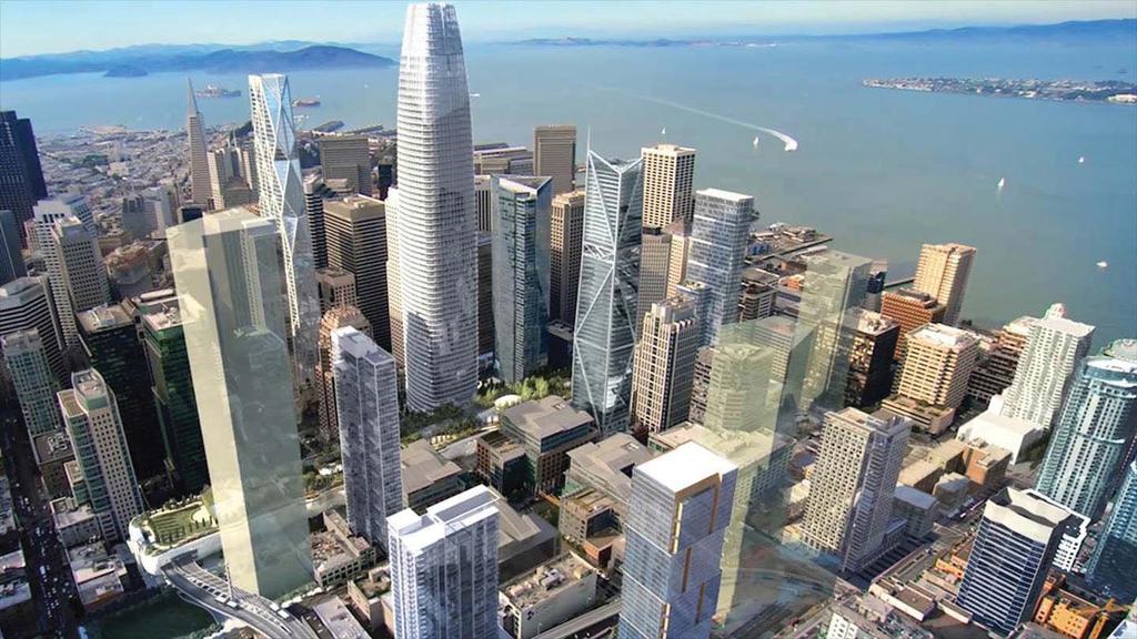
1 TRANSIT CENTER DISTRICT Public Realm TJPA CAC December 13, 2016
2 Today s Presentation Public Realm Projects for opening of TTC + SF Public Works + TTC Public Realm improvements in Rincon/Transit District + Previous planning, outreach and environmental analysis + Ongoing District-wide planning and outreach
3 1 Signalized 1 After Dec Unsignalized Priority Areas for Implementation Prior to December 2017
4 1 Signalized TJPA 1 Unsignalized CCSF 1 After Dec Others Priority Areas for Implementation Prior to December

5
6
7 !!!!!!!!!!!!!!!!!!!!!!!!!!!!!!!!!!!!!!!!!!!!!!!!!!!!!!!! t!!!!!!!!!!!!!!!!!!!!!!!!!!!!!!!!!!!! EMBARCADERO MARKET ST TRANSIT CENTER DISTRICT PLAN BOUNDARY!!!!!!!!!! MISSION ST!!!!!!! HOWARD ST 2ND ST 1ST ST FREMONT ST BEALE ST MAIN ST SPEAR ST STEUART ST!!!!!!!!!!!!!!!!!!!!!!!!!!!!!!!!!!!!!!!!!!!!!!!!!!! CENTRAL SOMA PLAN AREA TRANSIT CENTER ZONE 2 FOLSOM ST ZONE 1 HARRISON ST RINCON HILL AREA PLAN BRYANT ST TR BO TR ZO ZO RI 3RD ST Plan Areas


8 The format of this document will be modi ed to conform to the standardized format of the General Plan. D E PA R T M E N T August 2015 San Francisco Planning Department STREETSCAPE MASTER PLAN Rincon Hill SAN FRANCISCO PL ANNING NOVEMBER 2009 Transbay Streetscape & Open Space Concept Plan 1 San Francisco Redevelopment Agency DRAFT FOR PUBLIC REVIEW TRANSIT CENTER DISTRICT PLAN NOTE: SAN FRANCISCO PLANNING DEPARTMENT AN AREA PLAN OF THE GENERAL PLAN OF THE CITY AND COUNTY OF SAN FRANCISCO RINCON HILL 2017 Rincon/Transit Center Public Realm Strategy 2015 Rincon Hill Streetscape Plan Adopted by Planning Commission and Board of Supervisors 2012 Transit Center District Plan 2006 SFMTA Board Approves Rincon Circulation and Sidewalk Changes 2006 Transbay Redevelopment Streetscape Open Space Concept Plan 2005 Transbay Redevelopment Plan 2005 Rincon Hill Plan 2004 TJPA FEIS/EIR
9 Outreach Extensive outreach throughout the process 12+ years of public process From this process we created the plans and generated list of critical streetscape projects Most recent public process in Transbay was via the TCDP Process in 2012 Large Public Workshops Presentations to CACs Ongoing Project-Level Outreach (TJPA, OCII, Public Works) Public Realm Planning Process in 2017 (more later)
10 STEVENSON ST STEVENSON ST JESSIE ST AMBROSE BIERCE ST JESSIE ST MISSION ST HOWARD ST FOLSOM ST HARRISON ST ELIM ALY NATOMA ST TEHAMA ST GUY PL LANSING ST SANSOME ST BATTERY ST DAVIS ST FRONT ST STEUART ST SPEAR ST MAIN ST BEALE ST FREMONT ST 1ST ST 2ND ST NEW MONTGOMERY ST ANNIE ST ECKER ST Golden Gate University 50 1st Street 350 Mission ANTHONY ST MINNA ST SFMOMA 2nd and Howard Plaza Parcel F Shaw Plaza City Park 524 Howard Transit Tower Mission Square 181 Fremont Parcel M OCII Block 5 BUILDINGS Under Construction Entitled Preliminary Project Assessment Submitted (1st step in the entitlement process) Soft Site (Anticipated Development) Completed Project/Inactive Parcel 555 Howard MALDEN ALY HAWTHORNE ST OCII Block 7 OSCAR ALY KAPLAN LN CLEMENTINA ST CLEMENTINA ST OCII Block 9 OCII Block 8 OCII Block 6 OCII Block 1 ECKER ST 95 Hawthrone Under Ramp Park 41 Tehama THE EMBARCADERO ZENO PL OCII Block 11 OCII Block 4 OCII Block 3 (Transbay Park) OCII Block 2 75 Howard OPEN SPACE OCII TJPA POPOS STREETSCAPE Completed projects Improvement Required Through Entitlements (developer required) Improvement funded by CCSF (Non TDCP Revenue) Improvemnt funded by OCII Improvement funded by TJPA No Change in sidewalk needed (to be identified) Mid-block crossing GROTE PL ESSEX ST Hawthorne BOUNDARY Transbay Zone 1 Transbay Zone 2 Transit Center District Plan Rincon Hill Central SoMa SAINT FRANCIS PL DOW PL OCII Block 12 Transbay Pipeline Map Project Coorination + Plan implementation 3RD ST MARKET ST
11 Managing and Responding to Complexity To coordinate who is doing what, where, biweekly meetings are held with these City agencies SF Public Works (Project Management, Permitting, Design/Engineering) SFMTA (Transit Engineering & Traffic Routing, SFMTA Planning) SF Planning TJPA OCII Additional coordination as needed with Public Works disciplines, PUC staff, Private utility owners, Individual building owners and engineers
12 Future Public Realm Strategy Apply previously adopted goals and policies to future decisions Partnership between City and CBD Programming Open Spaces Improving Building Facades Materials and Planting Palettes Surgical Transport Improvements Prioritizing Next Waive of Public Investments
13 Thank You Shannon Cairns, Project Manager San Francisco Public Works Paul Chasan, Urban Designer San Francisco Planning Department
TRANSBAY JOINT POWERS AUTHORITY
 THIS STAFF REPORT COVERS CALENDAR ITEM NO.: 8 FOR THE MEETING OF: April 19, 2007 TRANSBAY JOINT POWERS AUTHORITY BRIEF DESCRIPTION: This staff report provides the status of a planning feasibility study
San Francisco Planning Department IPIC Report 2016
 San Francisco Planning Department IPIC Report 2016 and Expenditure Plan FY 2017 2018 San Francisco Planning Commission January 7, 2016 IMPLEMENTING OUR COMMUNITY PLANS The Plan Implementation Team manages
SAN FRANCISCO MUNICIPAL TRANSPORTATION AGENCY
 THIS PRINT COVERS CALENDAR ITEM NO.: 13 DIVISION: Sustainable Streets BRIEF DESCRIPTION: SAN FRANCISCO MUNICIPAL TRANSPORTATION AGENCY Endorsing the Planning Department s 2014 Update to the conceptual
FOLSOM-HOWARD STREETSCAPE OVERVIEW
 FOLSOM-HOWARD STREETSCAPE OVERVIEW SoMa residents should have the same kinds of amenities that other neighborhoods have. The Folsom- Howard Streetscape Project will make SoMa more livable by making it
The Bay Bridge Corridor Congestion Study
 Bay Bridge Corridor Congestion Study Tony Bruzzone, Arup TJPA Board Nov 1, 2010 Funded by AC Transit/Federal Transit Administration (FTA) Contracted with the Transbay Joint Powers Authority (TJPA) Stakeholders:
Freeway ramp intersection study
 Freeway ramp intersection study Supporting Vision Zero: Zero traffic deaths in San Francisco by 2024 Study Goals: Primary Improve Safety Improve Accessibility Secondary Provide Efficient Circulation Accommodate
FALL 2014 WORKSHOPS TAKEAWAYS
 SFMTA WORKSHOP FEEDBACK The SFMTA and partner agencies are continuing to utilize feedback from the Fall 2014 workshops to inform priorities and next steps for the Embarcadero Enhancement Project. Throughout
WATERFRONT TRANSPORTATION ASSESSMENT
 SFMTA Municipal Transportation Agency Image: Crosswalk of California Street and Grant Avenue WATERFRONT TRANSPORTATION ASSESSMENT 03 05 2013 SAN FRANCISCO, CALIFORNIA San Francisco: Focus of Regional Growth
Better Market Street Project. Project Update January 15, 2015
 Better Market Street Project Project Update January 15, 2015 Better Market Street Project Area Limits Market Street 2.2 Miles Mission Street Better Market Street Schedule Market Street City s busiest transit
PUBLIC REALM CENTRAL CORRIDOR EXISTING CONDITIONS ASSESSMENT PLANNING PROJECT
 PUBLIC REALM EXISTING CONDITIONS ASSESSMENT CENTRAL CORRIDOR PLANNING PROJECT SAN FRANCISCO PLANNING DEPARTMENT OCTOBER 2011 http://centralcorridor.sfplanning.org 2011 San Francisco Planning Department
ABOUT THIS OPEN HOUSE
 ABOUT THIS OPEN HOUSE Welcome, and thanks for joining us today for the Folsom-Howard Near-Term Project! The purpose of today s open house is to: Understand how the near-term project ties into the larger
WATERFRONT TRANSPORTATION ASSESSMENT T R A N S P O T A T I O N A U T H O R I T Y B O A R D SAN FRANCISCO, CALIFORNIA
 SFMTA Municipal Transportation Agency Image: Crosswalk of California Street and Grant Avenue WATERFRONT TRANSPORTATION ASSESSMENT T R A N S P O T A T I O N A U T H O R I T Y B O A R D 11 26 2013 SAN FRANCISCO,
Ann Arbor Downtown Street Plan
 1 Ann Arbor Downtown Street Plan Public Workshop #1 We know that. 2 Public right-of-way (streets, sidewalks, and alleys) make up 30% of the total District area of downtown. Streets need to provide mobility
Better Market Street Project Update. Urban Forestry Council September 17, 2014
 Better Market Street Project Update Urban Forestry Council September 17, 2014 Project Area Limits Better Market Street Schedule Market Street City s busiest transit corridor Over 85 buses per hour 14 surface
FINAL REPORT DECEMBER 2011
 FINAL REPORT DECEMBER 2011 AKNOWLEDGEMENTS SFMTA Staff Erin Miller, Project Manager Timothy Papandreou Jerry Robbins Pamela Stone Mike Sallaberry Chris Dimeling Emily Drennen Suzanne Chen-Harding San
BALBOA AREA: TRANSPORTATION PROJECTS & PLANNING
 BALBOA AREA: TRANSPORTATION PROJECTS & PLANNING TRANSPORTATION FOR ALL AGES, ABILITIES & MEANS CHANGING PATTERNS: TRENDING TO WALKING, BIKING, TRANSIT San Francisco s Change in Number of Commuters by Mode
Citizens Advisory Committee March 26, 2014
 Memorandum 0..1 Citizens Advisory Committee March, 1 Citizens Advisory Committee Maria Lombardo Chief Deputy for Policy and Programming Elizabeth Sall Interim Deputy Director for Planning Vision Zero Committee
Pedestrian Safety Workshop SAN FRANCISCO, CALIFORNIA
 Pedestrian Safety Workshop 02 15 2011 SAN FRANCISCO, CALIFORNIA 1 Agenda Walking in San Francisco Accomplishments and Current Pedestrian Activities Mayor s Pedestrian Safety Executive Directive Next Steps
District 6 & Citywide Non-Transit Project Delivery Status Report
 District 6 & Citywide Non-Transit Project Delivery Status Report Prop K and Non-Prop K Active Projects October 23, 2012 SAN FRANCISCO COUNTY TRANSPORTATION AUTHORITY SAN FRANCISCO COUNTY TRANSPORTATION
VISION ZERO SF: ELIMINATING TRAFFIC DEATHS BY 2024 JANUARY 5, 2017
 Through Vision Zero SF we commit to working together to prioritize street safety and eliminate traffic deaths in San Francisco by 2024 VISION ZERO SF: ELIMINATING TRAFFIC DEATHS BY 2024 JANUARY 5, 2017
ORDER NUMBER SPECIAL EVENTS REMEMBER: SERVICE IS OUR ONLY BUSINESS
 TO MUNI OPERATIONS PROFESSIONALS ORDER BULLETIN ORDER NUMBER SPECIAL EVENTS 2017-788 SF Pride Parade Service Order Sun, June 25, 2017 REMEMBER: SERVICE IS OUR ONLY BUSINESS Caution: 3 s: 2, 5, 6, 7, 8,
Office Development Annual Limitation ("Annual Limit") Program
 Program") Office Development Annual Limitation ("Annual Limit") Program The Office Development Annual Limit (Annual Limit) Program became effective in 1985 with the adoption of the Downtown Plan Amendments to the
Office Development Annual Limitation ("Annual Limit") Program The Office Development Annual Limit (Annual Limit) Program became effective in 1985 with the adoption of the Downtown Plan Amendments to the
AUTOMATED SPEED ENFORCEMENT: REDUCING SPEED TO SAVE LIVES
 Through Vision Zero SF we commit to working together to prioritize street safety and eliminate traffic deaths in San Francisco by 2024 AUTOMATED SPEED ENFORCEMENT: REDUCING SPEED TO SAVE LIVES INTRODUCING
CHAPTER 7.0 IMPLEMENTATION
 CHAPTER 7.0 IMPLEMENTATION Achieving the vision of the Better Streets Plan will rely on the ability to effectively fund, build and maintain improvements, and to sustain improvements over time. CHAPTER
Agenda. Overview PRINCE GEORGE S PLAZA METRO AREA PEDESTRIAN PLAN
 PRINCE GEORGE S PLAZA METRO AREA PEDESTRIAN PLAN May 28, 2008 Agenda Welcome and introductions Project overview and issue identification Planning context and strengths Design challenges and initial recommendations
SAN FRANCISCO MUNICIPAL TRANSPORTATION AGENCY BOARD OF DIRECTORS AND PARKING AUTHORITY COMMISSION NOTICE OF MEETING AND CALENDAR
 SAN FRANCISCO MUNICIPAL TRANSPORTATION AGENCY BOARD OF DIRECTORS AND PARKING AUTHORITY COMMISSION NOTICE OF MEETING AND CALENDAR Tuesday, November 15, 2016 Room 400, City Hall 1 Dr. Carlton B. Goodlett
modes, the increased roadway capacity is the implied solution, which, in turn, has been shown to lead to more driving (induced demand).
.") CONGESTION MANAGEMEN T PROGRAM DECEMBER, 201 7 EXECUTIVE SUMMARY A. Introduction Every two years, the San Francisco County Transportation Authority (SFCTA) prepares the San Francisco Congestion Management
CONGESTION MANAGEMEN T PROGRAM DECEMBER, 201 7 EXECUTIVE SUMMARY A. Introduction Every two years, the San Francisco County Transportation Authority (SFCTA) prepares the San Francisco Congestion Management
Palou Complete Street Project Barneveld Avenue to Crisp Road Project overview and concept design Community Meeting #2 May 13, 2015
 Palou Complete Street Project Barneveld Avenue to Crisp Road Project overview and concept design Community Meeting #2 May 13, 2015 Agenda Welcome and introductions Project overview, history and goals Concept
integrated action plan
 public presentation. june 24, 2009. city of portsmouth, nh islington corridor integrated action plan richardson & associates, landscape architects evan haynes, public arts consultant Islington Street Corridor
BD RESOLUTION NO RESOLUTION ADOPTING THE VISION ZERO RAMP INTERSECTION STUDY PHASE 1
 BD00 RESOLUTION NO. - RESOLUTION ADOPTING THE VISION ZERO RAMP INTERSECTION STUDY PHASE [NTIP PLANNING] FINAL REPORT WHEREAS, The Vision Zero Ramp Intersection Study Phase was recommended by Commissioner
FIRST AMENDMENT TO METRO NORTH CROSSING TAX INCREMENT FINANCING PLAN
 FIRST AMENDMENT TO METRO NORTH CROSSING TAX INCREMENT FINANCING PLAN KANSAS CITY, MISSOURI TIF COMMISSION APPROVAL: 12/13/17 12-2-17 DATE RESOLUTION NO. CITY COUNCIL APPROVAL: 2/1/18 180020 DATE ORDINANCE
Options. Agenda. Program
 July 2013 Workshops Agenda Parc 55 Main Library Open house 6-6:15pm 10-10:15am Presentation 6:15-7:00pm 10:15-11am Exhibit stations review & comments 7-8:20pm 11am - 12:20pm Meeting close 8:20-8:30pm 12:20-12:30pm
modes, the increased roadway capacity is the implied solution, which, in turn, has been shown to lead to more driving (induced demand).
.") EXECUTIVE SUMMARY A. Introduction The San Francisco Congestion Management Program (CMP) is a biennial program conducted in accordance with state law to monitor congestion and adopt plans for mitigating
EXECUTIVE SUMMARY A. Introduction The San Francisco Congestion Management Program (CMP) is a biennial program conducted in accordance with state law to monitor congestion and adopt plans for mitigating
Transit Center District Plan A Sub-Area Plan of the Downtown Plan
 Transit Center District Plan A Sub-Area Plan of the Downtown Plan Introduction The Transit Center District Plan builds on the City s renowned Downtown Plan that envisioned the area around the former Transbay
Ordinance amending Ordinance No. 1061, entitled "Regulating the Width of Sidewalks,"
 SUBSTITUTED FILE NO. 001 // ORDINANCE NO. - 1 1 [Amending Ordinance No. 1 - Sidewalk Width Change - Portions of Beale Street, Howard Street, Main Street, and Mission Street] Ordinance amending Ordinance
Van Ness Avenue Bus Rapid Transit (BRT) San Francisco Environment Commission Policy Committee
 San Francisco Environment Commission Policy Committee") Van Ness Avenue Bus Rapid Transit (BRT) San Francisco Environment Commission Policy Committee 04.30.12 Van Ness Avenue BRT Project Background Key north-south link in San Francisco s Rapid Transit network
Van Ness Avenue Bus Rapid Transit (BRT) San Francisco Environment Commission Policy Committee 04.30.12 Van Ness Avenue BRT Project Background Key north-south link in San Francisco s Rapid Transit network
BICYCLE STRATEGY UPDATE
 SFMTA Municipal Transportation Agency Image: Bike locks in front of San Francisco main library BICYCLE STRATEGY UPDATE 2015 SAN FRANCISCO, CALIFORNIA Bicycle Strategy Overview Four Goals: 1. Improve safety
Active TFCA Projects to Date - TFCA Allocations and Total Project Costs San Francisco County Transportation Authority
 Active s to Date - TFCA Allocations and Total Project Costs 11SF05 Solar Electric Vehicle Charging Stations $28,000 $74,967 Integrated Public-Private Travel Demand SFCTA 11SF07 Management (TDM) Partnership
Replace century-old sewer & water pipes Pedestrian-scale sidewalk lighting
 PROJECT OVERVIEW The Masonic Avenue Streetscape Project is an effort to improve safety for everyone travelling on Masonic Avenue between Geary Boulevard and Fell Street. This project will bring a variety
WHAT S NEXT? SAN FRANCISCO S MAJOR DEVELOPMENT AND INFRASTRUCTURE PROJECTS
 WHAT S NEXT? SAN FRANCISCO S MAJOR DEVELOPMENT AND INFRASTRUCTURE PROJECTS By: Tiffany Bohee, Executive Director, Office of Community Investment and Infrastructure November 3, 2014 1 INNOVATION CORRIDOR
New Planning Code Summary: Better Streets Plan and Curb Cut Restrictions
 New ning Code Summary: Better Streets and Curb Cut Restrictions Amended Sections: 138.1, 155(r) and 303(y) Case Number: 2018-008862PCA Board File/Enactment #: 180914/277-18 Initiated by: Supervisors Kim
In station areas, new pedestrian links can increase network connectivity and provide direct access to stations.
 The Last Mile Planning for Pedestrians Planning around stations will put pedestrians first. Making walking to stations safe and easy is important; walking will be a part of every rapid transit Accessible
DALLAS MIDTOWN REDEVELOPMENT PLAN FOCUS NORTH TEXAS Peer Chacko, AICP, Assistant Director, City of Dallas
 DALLAS MIDTOWN REDEVELOPMENT PLAN FOCUS NORTH TEXAS 2014 Peer Chacko, AICP, Assistant Director, City of Dallas Dallas Midtown: Strategic growth area Future transit node 2 Peterson Road Study Area Galleria
PRINCE GEORGE S PLAZA METRO AREA PEDESTRIAN PLAN
 PRINCE GEORGE S PLAZA METRO AREA PEDESTRIAN PLAN May 28, 2008 Agenda Welcome and introductions Project overview and issue identification Planning context and strengths Design challenges and initial recommendations
SAN FRANCISCO MUNICIPAL TRANSPORTATION AGENCY BOARD OF DIRECTORS AND PARKING AUTHORITY COMMISSION NOTICE OF MEETING AND CALENDAR
 SAN FRANCISCO MUNICIPAL TRANSPORTATION AGENCY BOARD OF DIRECTORS AND PARKING AUTHORITY COMMISSION NOTICE OF MEETING AND CALENDAR Tuesday, August 18, 2015 Room 400, City Hall 1 Dr. Carlton B. Goodlett Place
IMPLEMENTATION STRATEGIES
 GEORGETOWN SIDEWALK MASTER PLAN 34% of funding is dedicated to Downtown Overlay District sidewalks 28% of funding is recommended within 1/4 mile of Southwestern University 26% of funding is recommended
Memo. Ocean Avenue Corridor Design Project Public Workshop #2 Summary
 Ocean Avenue Corridor Design Project Public Workshop #2 Summary The second public workshop for the Ocean Avenue Corridor Design Project was held on Wednesday, May 14, 2014 from, 6 to 8 pm at Lick Wilmerding
First Mile, Last Mile: Plans for all Shapes and Sizes. Hannah Lindelof, Principal Planner San Francisco Bay Area Rapid Transit September 18, 2017
 First Mile, Last Mile: Plans for all Shapes and Sizes Hannah Lindelof, Principal Planner San Francisco Bay Area Rapid Transit September 18, 2017 BART Station Access Policy Goals A. Safer, Healthier, Greener.
Vision Zero Priority Projects (March 2017)
") Key in 201 or of Key Potrero Ave., from Division to Cesar Chavez Begin Construction Spring 201 Winter 201 Achieved Safety measures include dedicated transit lane, sidewalk widening, buffers for existing
Key in 201 or of Key Potrero Ave., from Division to Cesar Chavez Begin Construction Spring 201 Winter 201 Achieved Safety measures include dedicated transit lane, sidewalk widening, buffers for existing
TASK FORCE UPDATE MARCH 29, 2016
 Through Vision Zero SF we commit to working together to prioritize street safety and eliminate traffic deaths in San Francisco by 2024 MARCH 29, 2016 1 WHY WE RE HERE We never planned on losing our son.
RED COLORED TRANSIT-ONLY LANES REQUEST TO EXPERIMENT
 RED COLORED TRANSIT-ONLY LANES REQUEST TO EXPERIMENT Submitted to: California Traffic Control Devices Committee Federal Highway Administration, Office of Traffic Operations Submitted by: San Francisco
Arapahoe Square Zoning + Design Standards & Guidelines Task Force Meeting 9 January 27, 2016
 Arapahoe Square Zoning + Design Standards & Guidelines Task Force Meeting 9 January 27, 2016 Agenda 3:00 Opening/Welcome 3:15 Touch Base on Schedule and Milestones Moving Forward 3:20 Review the Overall
Geary Corridor Bus Rapid Transit SFMTA Citizens Advisory Committee
 Geary Corridor Bus Rapid Transit SFMTA Citizens Advisory Committee Project Update SAN FRANCISCO COUNTY TRANSPORTATION AUTHORITY SAN FRANCISCO MUNICIPAL TRANSPORTATION AGENCY August 6, 2015 Project Overview
WELCOME Mission-Geneva Transportation Study
 WELCOME Mission-Geneva Transportation Study Study Process and Schedule 2005 2006 Oct Nov Dec Jan Feb Mar Apr May Jun Jul Aug Sept Oct Task 2 Develop Outreach Plan Task 3 Document Existing Conditions/ Prioritize
Expansion of Bike Share within San Jose supports the City's ambitious mode shift goals to have 15% of commute trips completed by bicycles by 2040.
 COUNCIL AGENDA: 12/01/15 ITEM: 4 CITY OF SAN JOSE CAPITAL OF SILICON VALLEY TO: HONORABLE MAYOR AND CITY COUNCIL SUBJECT: BAY AREA BIKE SHARE EXPANSION Memorandum FROM: Jim Ortbal DATE: Approved Date irftt/ls'
Environment and Public Works Committee Presentation
 Mixed Use Centers Complete Streets Guidelines Project Environment and Public Works Committee Presentation December 10, 2008 Project Objectives: Conduct an inter-departmental and agency process to study
VISION ZERO: ELIMINATING TRAFFIC DEATHS BY 2024 MARCH 2015
 Through Vision Zero SF we commit to working together to prioritize street safety and eliminate traffic deaths in San Francisco by 2024 VISION ZERO: ELIMINATING TRAFFIC DEATHS BY 2024 MARCH 2015 VISION
Northside Livable Centers Study
 Northside Livable Centers Study Advisory Committee Meeting #2 Preferred Conceptual Plan March 2, 2010 AGENDA FOR ADVISORY COMMUNITY WORKSHOP #1 Project Overview and Timeline Planning Area Overview Workshop
Miami Health District
 Miami Health District Streetscapes, Gateways, and Signage Basis of Design Report Study Miami Partnership Meeting July 21, 2008 Gannett Fleming EDAW The Corradino Group Sponsored by the Miami Partnership:
City of San Francisco 2009 Pedestrian Count Report. April 2010
 April 2010 TABLE OF CONTENTS Introduction... 3 Background... 3 Methodology:... 4 Results... 4 Recommendations... 6 Conclusion... 7 APPENDIX A: CENSUS DATA... 8 APPENDIX B: COUNT LOCATIONS... 8 APPENDIX
Better Market Street. Engineering, Maintenance & Safety Committee (EMSC) February 28, 2018
 February 28, 2018") Better Market Street Engineering, Maintenance & Safety Committee (EMSC) February 28, 2018 1 Market Street Market Street - San Francisco by rulenumberone2 2 Market Street is the... City s busiest pedestrian
Better Market Street Engineering, Maintenance & Safety Committee (EMSC) February 28, 2018 1 Market Street Market Street - San Francisco by rulenumberone2 2 Market Street is the... City s busiest pedestrian
Addendum to Mitigated Negative Declaration
 Addendum Date: Case No.: 2014.1499E Project Title: (MDSP) - Mission Valencia Green Gateway Streetscape Project Original: 2008.1075, MDSP Mitigated Negative Declaration Project Sponsor: Charlie Ream, San
Broward Boulevard Gateway Implementation Project, Downtown Walkability Analysis, & Joint Development Initiative (JDI)
") Broward Boulevard Gateway Implementation Project, Downtown Walkability Analysis, & Joint Development Initiative (JDI) City of Fort Lauderdale ~ Commission Conference July 10, 2012 Page 1 of 15 A Multi-Agency
Broward Boulevard Gateway Implementation Project, Downtown Walkability Analysis, & Joint Development Initiative (JDI) City of Fort Lauderdale ~ Commission Conference July 10, 2012 Page 1 of 15 A Multi-Agency
SAN FRANCISCO MUNICIPAL TRANSPORTATION AGENCY
 THIS PRINT COVERS CALENDAR ITEM NO. : 10.2 DIVISION: Sustainable Streets BRIEF DESCRIPTION: SAN FRANCISCO MUNICIPAL TRANSPORTATION AGENCY Adopting Conceptual Proposal for Streetscape Improvements to Broadway,
COMMUNITY PARTICIPATION CHAPTER 8
 COMMUNITY PARTICIPATION CHAPTER 8 8.1 ROLE OF THE CITY S BICYCLE ADVISORY COMMISION 8.2 BICYCLE TRANSPORTATION PLAN STAKEHOLDERS 8.2.1 Stakeholders 8.2.2 Stakeholders Letters of Recommendations 8.3 CITY
TEMPORARY OCCUPANCY PERMITS. Street Space, Additional Street Space and Temporary Occupancy Permits PUBLIC WORKS CODE : ARTICLE 15, SEC.
 TEMPORARY OCCUPANCY PERMITS Street Space, Additional Street Space and Temporary Occupancy Permits PUBLIC WORKS CODE : ARTICLE 15, SEC. 724 Difference between the 3 permits. Who would apply for the permit?
ABOUT MUNI FORWARD. Muni Forward is the SFMTA s initiative to make transit safer and more reliable.
 TOPICS Service Planning Overview April 25 Service Increases Muni Forward General Update Haight Street Rapid Project McAllister Street Rapid Project New System Map and Related Bus Stop Changes 2 ABOUT MUNI
SAN FRANCISCO MUNICIPAL TRANSPORTATION AGENCY
 THIS PRINT COVERS CALENDAR ITEM NO.: 10.2 SAN FRANCISCO MUNICIPAL TRANSPORTATION AGENCY DIVISION: Sustainable Streets BRIEF DESCRIPTION: Approving various routine parking and traffic modifications. SUMMARY:
Data Analysis February to March 2018 Identified safety needs from reported collisions and existing travel patterns. SFMTA Board of
 Welcome! Thank you for participating in today s Valencia Data Analysis February to March 2018 Identified safety needs from reported collisions and existing travel patterns. First Community Event(s) July
Protected Bike Lanes in San Francisco Mike Sallaberry SFMTA NACTO Workshop - Chicago IL
 Protected Bike Lanes in San Francisco Mike Sallaberry SFMTA 10 14 2011 NACTO Workshop - Chicago IL San Francisco 2 nd Highest Density in the U.S. 47 square miles Mild Climate Market Population ~810,000
2/25/2015. The Best of Pro Walk Pro Bike Pro Place Continuing Education. Today s presenters
 The Best of Pro Walk Pro Bike Pro Place 2014 For technical assistance during the webinar, call 1 800 263 6317 Choose these audio prompts: 2, 1 February 25, 2015 Continuing Education To document Professional
Managed Lanes in California:
 Managed Lanes in California: Where We ve Been Where We re Going Joe Rouse Managed Lanes Manager California Department of Transportation Managed Lanes Defined Lanes that are proactively managed in response
Methodology for Determining Pedestrian Activity Factors
 Where People Walk: Methodology for Determining Pedestrian Activity Factors Part I: Background on the WalkFirst Project The goal of the WalkFirst project is to improve walking conditions in San Francisco,
I-105 ExpressLanes Project
 I-105 ExpressLanes Project Public Scoping Meetings March 2018 Introduction to Scoping This process is your opportunity to give us your thoughts on: The purpose and need for the proposed improvements The
Upper Market Street Bike Lane Project
 Upper Market Street Bike Lane Project 17th Street to Octavia Boulevard 6 30 2010 SAN FRANCISCO, CALIFORNIA Agenda San Francisco & Sustainable Transportation Project Goals Outreach & Coordination Project
Strategies for Maintaining & Renewing Innovative Street Projects. Elyse Parker, Director of Policy & Innovation, City of Toronto NACTO, LA, 2018
 Strategies for Maintaining & Renewing Innovative Street Projects Elyse Parker, Director of Policy & Innovation, City of Toronto NACTO, LA, 2018 1 OUR ASSETS $12B in Assets $20B Replacement Cost $372M Capital
SFMTA SAN FRANCISCO MUNICIPAL TRANSPORTATION AGENCY
 SFMTA SAN FRANCISCO MUNICIPAL TRANSPORTATION AGENCY VAN NESS BUS RAPID TRANSIT PROJECT UPDATE PRESENTATION TO SFMTA BOARD OF DIRECTORS RELEASE OF DRAFT ENVIRONMENTAL IMPACT STATEMENT / REPORT 10 18 2011
SPRINGFIELD REVITALIZATION REPORT
 SPRINGFIELD REVITALIZATION REPORT August 2015 Homewood Suites Springfield Town Center Promenade 2 SPRINGFIELD OVERVIEW This report covers recent development activity in the Springfield Commercial Revitalization
BALBOA PARK STATION COMMUNITY ADVISORY COMMITTEE (BPSCAC) Meeting Minutes
 Meeting Minutes") BALBOA PARK STATION COMMUNITY ADVISORY COMMITTEE (BPSCAC) Meeting Minutes Tuesday, July 28, 6:00-8:00pm City College (55 Phelan Ave), Multi-Use Building on first floor, Room 140 CAC Members Attendance:
BALBOA PARK STATION COMMUNITY ADVISORY COMMITTEE (BPSCAC) Meeting Minutes Tuesday, July 28, 6:00-8:00pm City College (55 Phelan Ave), Multi-Use Building on first floor, Room 140 CAC Members Attendance:
SAN FRANCISCO MUNICIPAL TRANSPORTATION AGENCY
 THIS PRINT COVERS CALENDAR ITEM NO. : 11 DIVISION: Sustainable Streets BRIEF DESCRIPTION: SAN FRANCISCO MUNICIPAL TRANSPORTATION AGENCY Approving traffic modifications on Twin Peaks Boulevard between Christmas
California Department of Transportation, District 4. Sloat Boulevard Project Skyline Blvd. to 19 th Ave. Community Update January 13, 2016
 California Department of Transportation, District 4 Sloat Boulevard Project Skyline Blvd. to 19 th Ave. Community Update January 13, 2016 Agenda Welcome and introductions Project overview, history and
Community Task Force July 25, 2017
 Community Task Force July 25, 2017 Welcome and Introductions Project Partners Regional Transportation District (RTD) Colorado Department of Transportation (CDOT) Denver Regional Council of Governments
Bicycle Master Plan Goals, Strategies, and Policies
 Bicycle Master Plan Goals, Strategies, and Policies Mobilizing 5 This chapter outlines the overarching goals, action statements, and action items Long Beach will take in order to achieve its vision of
ABOUT THE PROJECT. DOWNTOWN WEST Transportation Planning Study. Pennsylvania Ave. NW: H Street NW: Farragut. K St. NW. North. I St.
 ABOUT THE PROJECT Downtown West seeks to improve east-west travel for pedestrians and cyclists on Pennsylvania Avenue NW and persons using public transit along H and I Streets NW. K St. NW North I St.
The Role of MPOs in Advancing Safe Routes to School through the Transportation Alternatives Program
 The Role of MPOs in Advancing Safe Routes to School through the Transportation Alternatives Program In 2012, Congress made changes to Federal funding for Safe Routes to School that gave some metropolitan
Caltrans Sloat Boulevard Pedestrian Safety Project Response to Community Questions, Comments & Concerns
 Caltrans Sloat Boulevard Pedestrian Safety Project Response to Community Questions, Comments & Concerns Revised: May 10, 2016 The California Department of Transportation (Caltrans) is planning various
2019 Prop K 5-Year Prioritization Program Update Prop K Project Ideas - Public Survey Results
 Prop K Project Ideas - Public Survey Results As part of the 5YPP update outreach strategy, the Transportation Authority conducted a survey to gather input from the public about what projects people would
CITY OF VAUGHAN EXTRACT FROM COUNCIL MEETING MINUTES OF OCTOBER 30, 2012
 CITY OF VAUGHAN EXTRACT FROM COUNCIL MEETING MINUTES OF OCTOBER 30, 2012 Item 31, Report No. 39, of the Committee of the Whole, which was adopted without amendment by the Council of the City of Vaughan
Building Target Field
 Building Target Field Collaboration and partnerships were critically important to making Target Field a success -First, in how the facility FITS into the site -Second, in how the ballpark CONNECTS to transit,
VTA Development Review Program Annual Report for 2015
 VTA Development Review Program Annual Report for 2015 Web Version May 13, 2016 Presentation Outline I. Background II. Data Snapshot a. Development Review Activity for 2015 b. Select Projects Under Construction
WELCOME. Thank you for joining us at the Second Public Workshop for the Carlsbad Pedestrian Master Plan. We look forward to receiving your feedback.
 City of Carlsbad Pedestrian Master Plan: WELCOME WELCOME Please Sign In Provide Input at Flip Charts Review Boards Presentation of Draft Plan Thank you for joining us at the Second Public Workshop for
Project Status Update
 Project Status Update : Novato Boulevard, 4th & 3rd Streets, Sir Francis Drake Boulevard (3), and Miller Avenue Major roads projects target the most heavily traveled roads in Marin County for repairs,
VISION ZERO UPDATE JUNE 2, 2016
 Through Vision Zero SF we commit to working together to prioritize street safety and eliminate traffic deaths in San Francisco by 2024 VISION ZERO UPDATE JUNE 2, 2016 1 TRAFFIC FATALITIES - 2015 31 people
SAN FRANCISCO MUNICIPAL TRANSPORTATION AGENCY
 THIS PRINT COVERS CALENDAR ITEM NO. : 12 DIVISION: Sustainable Streets BRIEF DESCRIPTION: SAN FRANCISCO MUNICIPAL TRANSPORTATION AGENCY Approving various bicycle improvements and traffic modifications
OneBayArea Grant Application
 OneBayArea Grant Application ER Taylor Elementary School Safe Routes to School Project Submitted by the San Francisco Department of Public Works To the San Francisco County Transportation Authority April
THIS PRINT COVERS CALENDAR ITEM NO. : 12 SAN FRANCISCO MUNICIPAL TRANSPORTATION AGENCY. DIVISION: Sustainable Streets BRIEF DESCRIPTION:
 THIS PRINT COVERS CALENDAR ITEM NO. : 12 DIVISION: Sustainable Streets BRIEF DESCRIPTION: SAN FRANCISCO MUNICIPAL TRANSPORTATION AGENCY Approving a parking protected bikeway and parking and traffic modifications
SAFE STREETS FOR ALL. A Report to Land Use Committee on Street widths in Hunters Point Shipyard and Candlestick Point Developments
 SAFE STREETS FOR ALL A Report to Land Use Committee on Street widths in Hunters Point Shipyard and Candlestick Point Developments Background: Candlestick Point Hunters Point Shipyard Redevelopment Project
SAN FRANCISCO MUNICIPAL TRANSPORTATION AGENCY
 THIS PRINT COVERS CALENDAR ITEM NO.: 12 DIVISION: Transit BRIEF DESCRIPTION: SAN FRANCISCO MUNICIPAL TRANSPORTATION AGENCY Approving parking and traffic modifications along the 30 Stockton Muni transit
2.0 CHAPTER CONTEXT. 2.1 Existing Conditions 2.2 Regulatory Context 2.3 Existing City Efforts CONTEXT
 CHAPTER 2.0 CONTEXT 2.1 Existing Conditions 2.2 Regulatory Context 2.3 Existing City Efforts CONTEXT San Francisco is a walker s city a dense mix of uses, short blocks, and small streets combine to make