How to get there. Respect - Protect - Enjoy
|
|
|
- Myles Fox
- 5 years ago
- Views:
Transcription

1


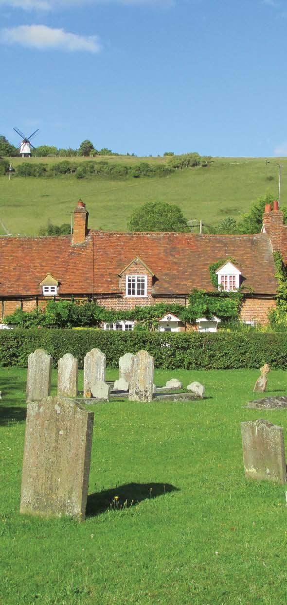
2 How to get there Driving: Postcode is RG9 6QU and there is a car park for customers. Nearest station: Marlow train station is 7.8 miles away. We re delighted to present three circular walks all starting and ending at The Bull and Butcher. The Brakspear Pub Trails are a series of circular walks. We thought the idea of a variety of circular country walks all starting and ending at our pubs was a guaranteed winner. We have fantastic pubs nestled in the countryside, and we hope our maps are a great way for you to get out and enjoy some fresh air and a gentle walk, with a guaranteed drink at the end perfect! Our pubs have always welcomed walkers (and almost all of them welcome dogs too), so we re making it even easier with plenty of free maps. You can pick up copies in the pubs taking part or go to brakspearaletrails.co.uk to download them. We re planning to add new pubs onto them, so the best place to check for the latest maps available is always our website. We absolutely recommend you book a table so that when you finish your walk you can enjoy a much needed bite to eat too. At the weekend, please book in advance, as this is often a busier time, especially our smaller pubs. And finally, do send us your photos of you out and about on your walk. We really do love getting Local bus services: The number 28 bus service from Red Eagle. Brakspear would like to thank the Trust for Oxfordshire s Environment and the volunteers who helped make these walks possible. As a result of these walks, Brakspear has invested in TOE2 to help maintain and improve Oxfordshire s footpaths. Reg. charity no Respect - Protect - Enjoy Respect other people: Consider the local community and other people enjoying the outdoors Leave gates and property as you find them and follow paths unless wider access is available Protect the natural environment: Leave no trace of your visit and take your litter home Keep dogs under effective control Enjoy the outdoors: Plan ahead and be prepared Follow advice and local signs For more info visit: publications/the-countryside-code


3 Hanger Wood Bolter End Turville Fingest Mousells Wood Frieth Great Wood Skirmett The Bull and Butcher Turville, Henley-on-Thames Buckinghamshire, RG9 6QU Tel: Hatchet Wood Route 1: Turville Skirmett Turville Distance: 3.6km (2.2 miles) Time: 1 hour Route 2: Turville Ibstone Turville Distance: 6.4km (4 miles) Time: hours Route 3: Turville Skirmett Frieth Fingest Turville Distance: 8.4km (5.2 miles) Time: 3 hours Brakspear recommends that all walkers bring a copy of the Chilterns Hills West Ordnance Survey map. You can borrow one from the pub for a refundable 10 deposit.
 Time: 1 hour 01 With your back to the Bull and Butcher, turn left and walk down the lane to the village green and church, both on your left.")

4 Route 1 Directions A short easy walk with no steep hills. Distance: 3.6km (2.2 miles) Time: 1 hour 01 With your back to the Bull and Butcher, turn left and walk down the lane to the village green and church, both on your left. Look out for a Chiltern Way marker on your right between cottages. 02 Follow this signed path through a gate into a field to see the windmill on the hill above. The village of Turville has become famous as the setting of the BBC TV Comedy the Vicar of Dibley. It has also featured in other TV programmes and films such as Midsomer Murders, Goodnight Mr Tom and Chitty Chitty Bang Bang. Cobstone Windmill overlooking Turville also featured in the film Chitty Chitty Bang Bang as the workshop of the inventor, Caractacus Potts. 03 Immediately turn right through another gate to walk across the field and into woodland. On reaching a lane, turn right, walk carefully downhill to the junction. 04 Cross the road and take the signed path opposite and follow the path across three fields emerging in the attractive hamlet of Skirmett. 05 Turn right along the lane and walk for about 250m along the road then turn right along a rough lane indicated by a footpath sign (hidden in the hedge on left of lane). Glen Bowman Cobstone Windmill 06 Go through the kissing gate and follow the narrow path up to the edge of the woodland. The path then follows along the edge of the wood with some lovely views of the surrounding countryside, and then turns left into the wood. 07 Keep going ahead until you reach a signed path on the right, take this path and walk downhill emerging from the wood with wonderful views of the windmill on the far hill. 08 Follow the path and when you reach a lane, cross the lane and continue diagonally right across the field to meet another path, the Chiltern Way, by the hedge line. The Chiltern Way is a long distance circular path around the Chilterns ANOB. Tony Grist St Mary s Church Turville 09 Bear right to a gate then keep straight ahead, eventually coming out of a wooded area to see the Turville nursery on your left. 10 You are now walking down a village lane to pass the church on your left and the village green ahead. 11 Turn right to return to the Bull and Butcher pub.


5 Route 2 Directions A medium length walk with one steep section. Distance: 6.4km (4 miles) Time: hours 01 With your back to the Bull and Butcher, turn left and walk along lane to the village green and church, both on your left. Look out for a Chiltern Way marker on your right between cottages. The village of Turville has become famous as the setting of the BBC TV Comedy the Vicar of Dibley. It has also featured in other TV programmes and films such as Midsomer Murders, Goodnight Mr Tom and Chitty Chitty Bang Bang. 02 Follow this path through a gate into a field and observe the windmill on the hill above, then immediately turn right through a gate and walk across a field and enter a small stretch of woodland. Cobstone Windmill overlooking Turville also featured in the film Chitty Chitty Bang Bang as the workshop of the inventor, Caractacus Potts. 03 On leaving the woodland cross a lane and pick up the path opposite. 04 Continue through woodland to reach a path junction then turn right down a track into Fingest. 05 When you reach a lane, turn left, walk past the church and turn left up Chequers Lane and continue on for 800m. 06 Turn left through double metal gates on a signed path and bridleway. Just before it enters the field after about 80m, bear right and follow the path gently climbing up the valley bottom. 07 Continue along the path for about 1100m. The path is clearly marked with painted arrows on the trees, until you reach a bridleway on the left. Steve Daniels Looking across Turville from Turville Hill St Nicholas s, Ibstone 08 Take the bridleway and walk up a steep slope between fences, with Ibstone House emerging into view, on the right, until you reach a public road. 09 Turn right and walk along the road for about 350m; at the next junction take the lane on the left signposted to St Nicholas church. After 300m you will see the entrance drive to the church on the right. There has been a church on this site for over 1,000 years. The present building dates from about 1200 and has many interesting features including one of the oldest wooden pulpits in England. 10 You can take an opportunity to visit St Nicholas Church or continue a short distance downhill until you reach a finger post on the left hand side of the lane indicating a footpath into woodland. 11 Follow this path along the edge of the wood and then into the wood until you reach painted way markers on a tree. 12 Go right to the fence line and left along a path with the fence on the right, then through a gate and downhill towards another gate and on to a descending woodland path with more gates. 13 The path emerges into an open field with Turville clearly in view ahead. 14 Continue ahead into the village, turning left on to the lane to return to Bull and Butcher.
6 Route 3 A medium length walk with some steep climbs. Directions 01 With your back to the Bull and Butcher turn right and walk down the lane for 400m to the first lane on the right, Dolesden Lane, and with Watery Lane ahead, take the signed footpath between these two lanes. It is a gap in the hedge with a sign opposite, but partly hidden. 02 Follow the grassy path, initially following a hedge on the left, then pass through the gap in the hedge, and at a junction of paths before a house, cross the style and take the permissive path. 03 When you reach a road turn right into Skirmett and then take the signed footpath on the left, just before The Frog public house. 04 Go through a gate by a bungalow and take the path to the right to reach a lane. 05 Turn left along the lane then take the signed bridleway on the right, up to and through woodland following arrows, and ignoring signed footpaths to the left. 06 Continue ahead passing the Old Sawmill, to reach a lane near St Katherine s Parmoor. St Katherine s Parmoor is a large country house and the Headquarters of the Sue Ryder Prayer Fellowship. The estate was once owned by the Knights Templar. The house has an interesting history; initially a 16th Century farmhouse, it was largely rebuilt and extended during a 200 year period when it was owned by local wealthy landowners called Doyle. In the mid 19thCentury it was sold to Henry William Cripps QC, who further remodelled the house. In the 1940s the house was leased to King Zog of Albania who was forced into exile after the Italian invasion in In 1947 Lord Parmoor, a descendant of Henry Cripps, sold the house and 12 acres to the Community of St. Katharine of Alexandria. In 1995 the last surviving member of the Community gave the house and grounds, now a Grade 2 Listed Building, to Lady Ryder. The house and grounds are available for events, conferences etc., and like many locations in the Chilterns it has been used in films and TV programmes. 07 Turn left and cross the lane to walk on the signed grassy path along the edge of the lane. Just past the drive to Parmoor Park Farm turn right on a signed footpath leading through a hedge to a farm yard. 08 Continue with a hedge on the left, then just past the barn turn right through a small gate and follow the path with another hedge on the left. 09 Turn left at the way marked path into Frieth, passing the church, to a road. Distance: 8.4km (5.2 miles) Time: 3 hours 10 Take the signed path opposite and cross an open area. Continue to the lane, then turn left and follow the lane uphill to Little Frieth. 11 Take the footpath on the right, by the post box, initially along an unmade road, and then as the road swings right, continue ahead into woodland along a narrow path between a hedge and a fence. 12 At a junction of paths by a waymarker post, turn left and follow the woodland path to a gate. 13 Turn right along a broad track and continue along the track passing a large pile of logs and through a gate into an open field, presenting an excellent view. 14 Cross the open hillside and enter Fingest Wood. Follow the path in Fingest Wood downhill to a gate where there is a wonderful view of Fingest and its Norman church. 15 Go through the gate, and continue downhill towards Fingest. 16 Turn left at the lane and walk past the Chequers public house on the left and St Bartholomew s Church on the right to a signed path on the right. St Bartholomew s church, a Grade I listed building, is surrounded by brick and flint churchyard walls, lined with ancient lime trees. The massive western Norman tower was built early in the 12th century and has unusual twin gables - it is believed that only one other similar construction exists in the country. Each side of the bell chamber has paired openings with semi-circular roll moulded arches. The tower once held two bells, only one of which remains, dating from The nave has impressive ancient woodwork to the roof, with five sets of principle rafters with collar beams supported by curved brackets and wind braces. The exterior of the church is roughcast and rendered in mellow ochre. 17 Take this path up to a path junction, then turn left and follow a path through woodland. 18 Cross a lane, taking the path opposite into a further stretch of woodland. 19 The path emerges into an open field, follow the path across a field to a gate with the Cobstone Windmill visible on the hillside above and to the right. 20 Turn left through a gate and take the track through another gate to emerge back in Turville. 21 Go left along the lane to return to Bull and Butcher.


7 The Bull and Butcher Opening Hours: Monday-Friday: 12pm-3pm & 5.30pm-11pm (Open all day throughout summer holidays) Saturday: 12pm-11pm Sunday: 12pm-10pm Kitchen Open: Monday-Friday: 12pm-2.30pm & 6pm-9pm Saturday: 12pm-3pm & 6pm-9pm Sunday: 12pm-4pm & 6pm-8pm Dog Friendly Family Friendly Garden/Patio Park the Car WiFi Access The Bull and Butcher Turville, Henley-on-Thames Buckinghamshire, RG9 6QU Tel: Download the App To follow Brakspear Pub Trails on your smartphone, simply download the free ViewRanger app from the Apple App Store or Google Play, then visit to find the full collection of walks. Pick your favourite route, download it in the app, then follow it using ViewRanger s offline GPS navigation. Brakspear, The Bull Courtyard, Bell Street Henley-on-Thames, Oxfordshire RG9 2BA info@brakspear.co.uk This info was correct at the time of going to print. Printed August 2017 v1 Glen Bowman - Turville Hill
How to get there. Respect - Protect - Enjoy
 How to get there Driving: Postcode is OX49 5HL with a car park for customers Nearest station: Henley on Thames station is 9.5 miles away. We re delighted to present three circular walks all starting and
How to get there. Respect - Protect - Enjoy
 How to get there Driving: Postcode is OX10 6AD with a car park for customers. Nearest station: Goring & Streatley station is 5.6 miles away. We re delighted to present three circular walks all starting
How to get there. Respect - Protect - Enjoy
 How to get there Driving: Postcode is RG9 3DG and there is a carpark just across from the pub. Nearest station: Henley-on-Thames station is 5.6 miles away. We re delighted to present three circular walks
How to get there. Respect - Protect - Enjoy
 How to get there Driving: Postcode is RG9 5PF and there is a car park just across from the pub. Nearest station: Henley-on-Thames station is 5.6 miles away. We re delighted to present three circular walks
Views! village, woodland, hills, high trails, fine houses, hidden church
 point your feet on a new path Heath Distance: 9½ km=6 miles Region: Chilterns Author: Phegophilos Refreshments: easy walking Date written: 13-oct-2017 Map: Explorer 171 (Chiltern Hills West) but this guide
Fingest, Christmas Common, Pishill, Turville Red Kites and Red Deer
 point your feet on a new path Fingest, Christmas Common, Pishill, Turville Red Kites and Red Deer Distance: 23 km=14 miles Region: Chilterns Author: Bryntafion Refreshments: every village! Map: Explorer
Bakewell Club Site - Robin Hood's Stride
 Bakewell Club Site - Robin Hood's Stride Camping and Caravanning Route Summary A circular walk with fabulous views winding it's way through the beautiful White Peak scenery. Points of interest include
Harlington - Sharpenhoe - Pulloxhill
 Harlington - Sharpenhoe - Pulloxhill ID: 3676, Distance: 8 miles, Height gain: 140 Metres, Map: Explorer 193 Luton & Stevenage, Contributor: Dennis Jeanes Duration: 3 Hours 27 Mins Features Church,Great
Follow the Lantern Way clockwise from Dursley Town Hall through Cam & Coaley to Uley and back to Dursley (about 14 miles)
") According to the Rev Kilvert's diary of 1873, couples on their way to evening services in winter followed a practical though unusual local tradition: "My Mother says that at Dursley, when ladies and gentlemen
According to the Rev Kilvert's diary of 1873, couples on their way to evening services in winter followed a practical though unusual local tradition: "My Mother says that at Dursley, when ladies and gentlemen
Welsh Newton and Woodland
 Welsh Newton and Woodland This is a 8.2km miles (approx) walk which will take about 2.5 hours at a relaxed and leisurely pace. There are a few hills but no steep inclines. Start at Llangrove bus stop and
Walk Description. Directions
 Title: Saffron Trail: Battlesbridge to Chelmsford Distance: 14¾ miles Time taken: 6 hours Start Point: Outside the Barge Inn, Battlesbridge OS Explorer Map: 175 & 183 Grid Ref.: TQ 780 947 Transport: Rail:-
This walk description is from happyhiker.co.uk
 This walk description is from happyhiker.co.uk Pendle Hill Walk From Barley Starting point and OS Grid reference Ordnance Survey map Distance Traffic light rating Barley village honesty box car park OS
Approximate distance: 10 miles For this walk we ve included OS grid references should you wish to use them. Start. End
 Approximate distance: 10 miles For this walk we ve included OS grid references should you wish to use them. 2 3 Start End 1 N W E S Reproduced by permission of Ordnance Survey on behalf of HMSO. Crown
9.5 km Circular 3 hours
 RANMORE CIRCULAR A 6 mile (9.5km) circular walk from Boxhill and Westhumble Station in the village of Westhumble, passing through part of the Polesden Lacey Estate, Ranmore Common and Denbies Vineyard.
THE DOG AND DUCK HAREWOODS ESTATE TRAIL. 6 Miles Circular 3 hours. Getting there. Walk Sections
 THE DOG AND DUCK HAREWOODS ESTATE TRAIL Moderate Terrain A 6 mile circular pub walk from the Dog and Duck in Outwood, Surrey. The Dog and Duck is a delightful pub where everyone is made welcome. From walkers
Bix and the Assendons
 point your feet on a new path Bix and the Assendons Distance: 8½ km=5½ miles Region: Chilterns Author: Phegophilos Refreshments: Lower and Middle Assendon Map: Explorer 171 (Chiltern Hills West) hopefully
NEWLANDS CORNER AND ST MARTHAS
 NEWLANDS CORNER AND ST MARTHAS 10k CIRCULAR ROUTE 2½-3HRS GU4 8SE From Newlands Corner on the North Downs just outside Guildford, you can enjoy one of the most beautiful panoramas of quintessential English
THE WELLDIGGERS ARMS, HESWORTH AND FITTLEWORTH TRAIL
 THE WELLDIGGERS ARMS, HESWORTH AND FITTLEWORTH TRAIL 5.5 miles Circular 3 hours 041017 Challenging Terrain A 300-year-old pub turned country-inn on the edge of the South Downs National Park, The Welldiggers
9.5 km Circular 3 hours
 MEDIEVAL WAVERLEY Challenging Terrain A 6 mile (9.5km) undulating circular walk from Tilford village passing close to The Sands village and the historic ruins of Waverley Abbey. From the top of Crooksbury
Danbury Words and pictures by Laurie Page of the Public Rights of Way team at Essex County Council.
 Danbury Words and pictures by Laurie Page of the Public Rights of Way team at Essex County Council. An undulating walk from Danbury village to the bluebells at the National Trust property of Blakes Wood.
Hammer Vale and Linchmere Common
 point your feet on a new path Hammer Vale and Linchmere Common Distance: 9 km=5½ miles or 6 km=3¾ miles easy walking with one steep section Region: Hampshire, West Sussex Author: Botafuego Refreshments:
The Mendip Way. Route Directions and Maps Wells to Frome
 The Mendip Way Route Directions and Maps Wells to Frome Website: www.mendiphillsaonb.org.uk Email: mendip@mendiphillsaonb.org.uk Facebook & Twitter: @MendipHillsAONB Phone: 01761462338 1 Wells to Shepton
8 Miles Circular 4 hours
 VISIT RYEDALE HELMSLEY AND RICCAL DALE 8 Miles Circular 4 hours 090616 Challenging Terrain An 8 mile (13km) circular walk from the market town of Helmsley in Ryedale. The route heads out across sheep pastures
The North Pennines from near Langwathby
 3.6 Langwathby to Armathwaite Map panel?? Distance 12.7 miles (20.5 km) Terrain farm, woodland and riverside paths; some potentially muddy tracks; a few short sections of road Grade gently undulating Food
Beautiful Walks from the Blue Ball Inn
 Walk No. 7 COAST AND VALLEY WALK Countisbury, Glenthorne, County Gate, Brendon, Rockford and Wilsham 10 MILES APPROX. Walking time 5 hours approx. (not including breaks)> OS Sheet 64/74 Lynton and Lynmouth.
LDWA SOUTH DOWNS MARATHON 13 th MAY 2018
 AHD ahead SDW South Downs Way BL/BR bear left/bear right TL/TR turn left/turn right X cross LEG 1 - EAST DEAN to WP1 NORTON GR 470019. Open 1030 to 1300. 9.7 miles. 1.1 From village hall TL and walk to
Route: Skewsby Foulrice Stearsby
 Route: Skewsby Foulrice Stearsby Distance: 7 miles Map: Explorer: 300 Howardian Hills & Malton Start (OS ref): SE625710 Park in the village of Skewsby. Walk east out of the village to the T-Junction and
BALCOMBE AND ARDINGLY RESERVOIR, WEST SUSSEX
 BALCOMBE AND ARDINGLY RESERVOIR, WEST SUSSEX 7 miles Circular 4 hours 080816 Challenging Terrain Hi, I'm Luke and this is my West Sussex Weekends walk It's a 7 mile loop from Balcombe rail station, taking
Sweetwater and the Holy Well Witley Station, Hambledon, Chiddingfold
 point your feet on a new path Sweetwater and the Holy Well Witley Station, Hambledon, Chiddingfold Distance: 7½ km= miles Region: Surrey Author: Schwebefuss Refreshments: Hambledon, Chiddingfold easy walking
RILLINGTON TO MALTON by Tania Dickinson
 RILLINGTON TO MALTON by Tania Dickinson This walk takes you from the Vale of Pickering up on to the Wold scarp, before dropping down again through the pretty village of Settrington and joining the Centenary
NETTLESTEAD & YALDING
 NETTLESTEAD & YALDING ULL CIRCUIT - Sheet 1 (first and last sections) Open fields (see 'Introductory Notes') 88 Direction label (as in the walk notes) ROADS: 81 10m Significant roads Redhill arm North
Walks Around Bishopstone & Hinton Parva
 The Walks: From ½ mile ambles to 8 mile scenic loops Hinton Parva Walks H1 H2 H3 Bishopstone Walks B1 B2 B3 B4 B5 Walk B1: Bishopstone Village, The Dingle (stream) & Pond A short circular village amble
The Hundred Parishes
 The Hundred Parishes Walks from railway stations number 9 6.4 miles (10kms) from Bishop s Stortford to Stansted Mountfitchet Start: Bishop s Stortford station (Grid Reference TL492209) (ample parking and
A circular walk of or km (2 1 4 or miles)
") Grantham A circular walk of 3 3 4 or 5 3 4 km (2 1 4 or 3 1 2 miles) Introduction This relatively short circular walk, which starts in the middle of Grantham, offers plenty of variety. The route takes
Grantham A circular walk of 3 3 4 or 5 3 4 km (2 1 4 or 3 1 2 miles) Introduction This relatively short circular walk, which starts in the middle of Grantham, offers plenty of variety. The route takes
Redesdale Arms. A Trio of Walks
 Redesdale Arms A Trio of Walks Welcome to The Redesdale Arms Hotel The award winning 34 bedroom Redesdale Arms Hotel sits at the gateway to the Cotswolds in the High Street of the historic town of Moreton-in-Marsh.
LDWA SOUTH DOWNS MARATHON
 AHD ahead SDW South Downs Way BL/BR bear left/bear right TL/TR turn left/turn right SP signpost/fingerpost X cross LEG 1 - EAST DEAN to WP1 NORTON GR 470019. Open 1030 to 1300. 9.6 miles. 1.1 From village
Aston Village: The Flowerpot (pub walk)
") point your feet on a new path Aston Village: The Flowerpot (pub walk) Distance: 10 km=6¼ miles or 8 km=5 miles (omitting the weir) Region: Berkshire, Chilterns Author: MacMeadow Refreshments: Henley, Aston
point your feet on a new path Aston Village: The Flowerpot (pub walk) Distance: 10 km=6¼ miles or 8 km=5 miles (omitting the weir) Region: Berkshire, Chilterns Author: MacMeadow Refreshments: Henley, Aston
Key Information. Self-Guided Walk Exploring Sedbergh
 Self-Guided Walk Exploring Sedbergh A great short walk - ideal for an early evening in summer. This is a lovely circuit of Sedbergh visiting some of the historic buildings as well as ambling by the river
Lincolnshire Limewoods Walks. Woodhall Spa. A circular walk of 13km (8 miles)
") Lincolnshire Limewoods Walks Woodhall Spa A circular walk of 13km (8 miles) Introduction The Lincolnshire Limewoods is an area between Wragby, Bardney and Woodhall Spa. It is a fantastic place to explore
Lincolnshire Limewoods Walks Woodhall Spa A circular walk of 13km (8 miles) Introduction The Lincolnshire Limewoods is an area between Wragby, Bardney and Woodhall Spa. It is a fantastic place to explore
Distance: 9½ km=5¾ miles moderate walking or two walks of 4¼ km=2¾ miles and 6½ km=4 miles
 point your feet on a new path White Hill, Headley Distance: 9½ km=5¾ miles moderate walking or two walks of 4¼ km=2¾ miles and 6½ km=4 miles Region: Surrey Author: Fusszweig Refreshments: Headley Date
Walk Description. Directions
 Title: East Hanningfield Distance: 8 miles / 9 miles Time taken: 3-3½ hours Location: 5 miles south east of Chelmsford Parking: Free car park off The Tye, East Hanningfield, next to the primary school
Distance: 14 km=8½ miles or 7 km=4½ miles easy-to-moderate walking
 point your feet on a new path Normandy Distance: 14 km=8½ miles or 7 km=4½ miles easy-to-moderate walking Region: Surrey Author: Botafuego Refreshments: Pirbright, Ash date written: 20-feb-2012 date revised:
Husthwaite to Byland Abbey
 Husthwaite to Byland Abbey This walk begins with a loop round the village of Husthwaite and continues towards Coxwold along a disused railway line, which is now a right of way. It passes through Coxwold
9.5 km Circular 3 hours
 SILENT POOL AND ST MARTHA S HILL Challenging Terrain A 9.5km (6 mile) circular walk in the Surrey Hills, visiting a number of popular attractions including Silent Pool, a stretch of the North Downs Way,
holly tree Wellhill Farm Woodyard Bramham House red kites Round House ha-ha
 This 6.4 mile walk around the magnificent Bramham Park Estate has been made possible with the active support of the owner of the Estate, Nick Lane Fox, with funding from Natural England, as part of Defra
Distance: 15 km=9 miles, with 2 optional diversions 1-2 km each easy walking
 point your feet on a new path Hascombe from Afar Distance: 15 km=9 miles, with 2 optional diversions 1-2 km each easy walking Region: Surrey Author: Schwebefuss Refreshments: Hascombe Date written: 9-may-2010
Outwood: oaks, buttercups and windmill
 point your feet on a new path Outwood: oaks, buttercups and windmill Distance: 9 km=5½ miles Region: Surrey Author: Schwebefuss Refreshments: Outwood easy walking Date written: 23-may-2014 Last update:
LOCAL CIRCUIT EM1: EAST MALLING & BARMING HEATH. N 2m ROADS: Significant roads PATHS: Starting direction Barming Longsole Mission Church
 Ditton Church Scott Close LOCAL CIRCUIT EM1: EAST MALLING & BARMING HEATH 6 Community Centre F Open fields (see 'Introductory Notes') 1m 88 Direction label (as in the walk notes) East Malling Church -
Winterfold Wood. point your feet on a new path. In Brief
 point your feet on a new path Winterfold Wood Distance: 8½ km=5¼ miles Region: Surrey Author: Schwebefuss Refreshments: Windmill Inn, Peaslake after the walk moderate walking with many gradients Date written:
HARDMOORS 26.2 WHITE HORSE HALF ROUTE DESCRIPTION - 018
 HARDMOORS 26.2 WHITE HORSE HALF ROUTE DESCRIPTION - 018 Follow Cleveland Way, keeping to the left hand path (right path is a bike trail) Ignoring any turnings to the left or right At path junction (after
Approximate distance: 5.5 miles For this walk we ve included OS grid references should you wish to use them. Start. End
 Approximate distance: 5.5 miles For this walk we ve included OS grid references should you wish to use them. End 4 1 Start 3 2 N W E S Reproduced by permission of Ordnance Survey on behalf of HMSO. Crown
Hascombe and Winkworth Arboretum Downs Link Path, Smithbrook Kilns
 point your feet on a new path Hascombe and Winkworth Arboretum Downs Link Path, Smithbrook Kilns Distance: 18 km=11 miles Region: Surrey Author: RDC easy walking Date written: 7-may-2016 Last update: 30-aug-2018
Stokenchurch. Bluebell Woods, Bomber Memorial, Red Kites, Getty s Cricket Ground, Nature Reserve
 Stokenchurch Bluebell Woods, Bomber Memorial, Red Kites, Getty s Cricket Ground, Nature Reserve Bomber Memorial The best time to visit Cowleaze Wood is in the spring when there is a memorable display of
Lincolnshire Walks. Ancaster. Three cir cular walks of2 3/4,4or 6km (11/3, 21/2 or 33/4 miles)
") Lincolnshire Walks Ancaster Three cir cular walks of2 3/4,4or 6km (11/3, 21/2 or 33/4 miles) Introduction These walks are set in the attractive countryside around the historic town of Ancaster. The town
Lincolnshire Walks Ancaster Three cir cular walks of2 3/4,4or 6km (11/3, 21/2 or 33/4 miles) Introduction These walks are set in the attractive countryside around the historic town of Ancaster. The town
6.5 km Circular 2 hours
 REIGATE MILLS AND PILLBOXES A 4 mile (6.5km) enjoyable circular walk from Reigate Heath, passing Reigate Heath windmill, Wonham Mill and pillboxes built during the Second World War. 6.5 km Circular 2 hours
Dyrham and Hinton Parish Walks
 Dyrham and Hinton Parish Walks A series of five walks in the parish, exploring most of the public footpaths. By John Miller Each walk is described in detail, with a complete map, to provide a handy guide
Weatherman Walking. Approximate distance: 5.5 miles For this walk we ve included OS grid references should you wish to use them. Start.
 Approximate distance: 5.5 miles For this walk we ve included OS grid references should you wish to use them. 4 1 Start End 3 2 N W E S Reproduced by permission of Ordnance Survey on behalf of HMSO. Crown
Walk 2: Beamsley Beacon and Bolton Abbey
 Walk 2: Beamsley Beacon and Bolton Abbey Start and Finish: The Memorial Hall, Main Street, Addingham, LS29 0LZ, SE 079 497 The shortest walk is about 5½ miles (8.8km) The medium Walk is about 8¼ miles
Bledlow Beechwoods and Bledda s Rest
 point your feet on a new path Beechwoods and Bledda s Rest Distance: 16 km=10 miles Region: Chilterns Author: Phegophilos Refreshments:, Bennett End moderate walking Date written: 2-sep-2010 Last update:
Effingham to Westhumble
 Main walk morning last checked Main walk afternoon last checked Pub diversion last checked Westhumble Circular last checked 12 December 2017 23 December 2017 19 August 2015 27 October 2017 Document last
Slindon Folly - South Downs, West Sussex
 Slindon Folly - South Downs, West Sussex Starts at Park road-side near entrance to Slindon College 2 hours 15 minutes 4.5miles 7.2km Easy ID: 0.1598 Developed by: Chris Mumford Checked by: Rockpit www.ramblersroutes.org
10 Miles Circular 5 hours
 VISIT RYEDALE PICKERING AND CAWTHORN CAMPS 10 Miles Circular 5 hours Moderate Terrain 120616 A 10 mile (16km) there and back walk from the market town of Pickering in Ryedale. The route heads north through
Bonnie Prince Charlie Walk
 Bonnie Prince Charlie Walk A waymarked route from Ashbourne to Derby to celebrate the 60th anniversary (1995) of the formation of the Ramblers' Association. This route follows the general direction of
Lincolnshire Walks. Grainthorpe. Three circular walks of 2 ¾, 9 and 9 ½ km (1 ¾, 5 ½ and 6 miles)
") Lincolnshire Walks Grainthorpe Three circular walks of ¾, 9 and 9 ½ km (1 ¾, ½ and 6 miles) Introduction Explore the coastal marshes, arable hinterland, Louth Navigation canal and the village of Grainthorpe
Lincolnshire Walks Grainthorpe Three circular walks of ¾, 9 and 9 ½ km (1 ¾, ½ and 6 miles) Introduction Explore the coastal marshes, arable hinterland, Louth Navigation canal and the village of Grainthorpe
Walk 7: Watchet to washford
 Walk 7: Watchet to washford Length: Moderate - 7.5 miles / 12 km Good For: Theme: History Duration: 2-3 hours depending on speed of walking Notes: This is a moderate to difficult walk in places, with steps,
Chipstead to Kingswood walk
 Saturday Walkers Club www.walkingclub.org.uk Chipstead to Kingswood walk Ancient woodland, open downs and farmland in London's Green Belt Length OS Map Toughness Features Main Walk: 15½ km (9.6 miles).
For Your Own Safety. Please make a note below of the contact number that should be used in the event that you get lost or require other assistance
 Respect Protect Enjoy Respect other people Consider the local community and other people enjoying the outdoors Leave gates and property as you find them and follow paths unless wider access is available
Banstead: Village and Woods
 point your feet on a new path : Village and s Distance: 10 km=6 miles Region: Surrey Author: Fusszweig Refreshments:, The Ramblers Rest easy walking Date written: 2-apr-2014 Last update: 11-apr-2017 Map:
The main feature of this tranquil walk is a visit to the source of the Thames (the Thames head) which is in a field just 3 km from Kemble station
 which is in a field just 3 km from Kemble station") SWC Walk DRAFT Kemble circular: the source of the River Thames. The main feature of this tranquil walk is a visit to the source of the Thames (the Thames head) which is in a field just 3 km from Kemble
SWC Walk DRAFT Kemble circular: the source of the River Thames. The main feature of this tranquil walk is a visit to the source of the Thames (the Thames head) which is in a field just 3 km from Kemble
Walking Pembrokeshire.
 Walking Pembrokeshire Canaston Woods Walk It s good to walk, so why not step out and sample some of the walks your neighbourhood has to offer. This pleasant and interesting walk which starts and finishes
GENERAL INFORMATION PLEASE FOLLOW THE COUNTRYSIDE CODE:
 KNIGHTON CIRCULAR WALKS The East Radnor Group of the Ramblers Association invites you to enjoy these walks around Knighton. Knighton is an excellent centre for walks in the lovely unspoilt mid-wales countryside
For more information and to buy this book click here ISBN: CICERONE. Guides for walkers, trekkers, mountaineers, climbers and cyclists
 For more information and to buy this book click here ISBN: 9781852845377 CICERONE Guides for walkers, trekkers, mountaineers, climbers and cyclists www.cicerone.co.uk WALK 5 Ouston and Urpeth Distance
Heartwood Forest, in Sandridge, Hertfordshire, is a place where everyone can find space, peace, wildlife and miles of beautiful woodland to explore.
 Heartwood Forest Accessibility Statement September 2016 Purpose: This accessibility statement outlines the available facilities and access information for Heartwood Forest. Welcome We, the Woodland Trust,
Masson Hill. Walk. Approximately 4 km. Moderate Walk Begins from Matlock Railway Station
 Masson Hill Walk Approximately 4 km Moderate Walk Begins from Matlock Railway Station TOWN WALKS Masson Hill walk is approx. 4 km. It can be walked in a couple of hours or so. Enjoy your walk and the beautiful
11 Miles Linear 5 to 6 hours
 11 Miles Linear 5 to 6 hours Sussex Hospices Trail Part 21: BALCOMBE TO HORSHAM Moderate Terrain 030918 An 11 mile linear walk from Balcombe rail station to Horsham rail station in West Sussex, forming
Fertile farms in the heart of Kent
 55 55 Fertile farms in the heart of Kent A bright sunny day is perfect for enjoying the rich and fertile Kent countryside and outstanding views across the valley of the Great Stour to the North Downs.
Dorridge & District Residents Association A Walk Along The Green Belt From Dorridge to Catherine-de-Barnes
 Dorridge & District Residents Association A Walk Along The Green Belt From Dorridge to Carine-de-Barnes The starting section of this walk through open fields would be destroyed by building of motorway
Nuffield, Grim's Dyke, Checkendon, Highmoor
 point your feet on a new path Nuffield, Grim's Dyke, Checkendon, Highmoor Distance: km= miles Region: Chilterns Author: Phegophilos Refreshments: Ipsden, Checkendon, Stoke Row, Nettlebed Map: Explorer
West Marden and Stansted Forest
 point your feet on a new path West Marden and Forest Distance: 3½ km=8½ miles easy walking with optional ½ km=½ miles extension to Rowlands Region: West Sussex Author: Hautboy Refreshments: West Marden,
The Worcestershire Beacon Race Walk. The Worcestershire Beacon Race Walk
 The Worcestershire Beacon Race Walk This is an abridged version of walk 5, taken from the Pictorial Guide to the Malvern Hills Book Two: Great Malvern. Copies are available from the Tourist Information
THE PONTON PLOD - 27 MILE ROUTE
 THE PONTON PLOD - 27 MILE ROUTE Emergency Phone Number 07771 813514 Abbreviations: BW Bridleway X Cross immd immediately FP Footpath TL Turn left L Left thro through KG Kissing Gate TR Turn right R Right
Loch Ness Shores Club Site
 Loch Ness Shores Club Site Camping and Caravanning Falls of Foyers Route Summary A strenuous walk from Loch Ness Shores Club Site. The route climbs through forest to The Upper Foyers Waterfall and then
Country town, fields, woodland, villages, views, arrival by Underground
 point your feet on a new path Chesham Distance: 9 km= miles or 5 km=9½ miles or km=7 miles Region: Chilterns Author: Phegophilos Refreshments: Lee Common, Hyde Heath, Chesham easy walking Date written:
CHINTHURST HILL AND THE GRANTLEY ARMS, SURREY
 CHINTHURST HILL AND THE GRANTLEY ARMS, SURREY 4 miles Circular 2 hours 110417 Challenging Terrain A 4 mile (can be shortened to 3 miles) circular pub walk near Wonersh in Surrey. The walk begins with an
Clyde Walkway Community Links: Nemphlar Moor Road to Braidwood
 Clyde Walkway Community Links: Nemphlar Moor Road to Braidwood Nemphlar Moor Road to Braidwood Digital Trail Difficulty (out of 3) 2 Distance Main route to Braidwood (shortest) 2.5km, 5km return. Detours
Chanctonbury, Steyning & the South Downs A Ring with a View
 point your feet on a new path Chanctonbury, Steyning & the South Downs A Ring with a View Distance: 12½ km=8 miles easy-to-moderate walking Region: West Sussex Date written: 5-aug-2010 Author: Hautboy
Sutton Valence or Harrietsham to Pluckley
 Sutton Valence start last checked Harrietsham start last checked Rest of walk last checked 22 April 2018 30 March 2017 3 June 2017 Document last updated: 2 May 2018 This document and information herein
Walk 3 - Woodbridge and Melton A Walk Round Waldringfield by Sue and Jim Stacey. Woodbridge. shopping centre, cafes, toilets etc. tide mill.
 Walk 3 - Woodbridge and Melton A Walk Round Waldringfield by Sue and Jim Stacey. road with roundabout church railway with station walk route showing description direction track, wide path, bridlepath footpath
Brightwalton, Chaddleworth, Leckhampstead, Peasemore: Four Downland Villages
 point your feet on a new path Brightwalton, Chaddleworth, Leckhampstead, Peasemore: Four Downland Villages Distance: 13 km=8 miles Region: Berkshire Author: MacMeadow Refreshments: Peasemore, Leckhampstead
SUMMER WALK 10. The Chairmakers, Worlds End
 SUMMER WALK 10 The Chairmakers, Worlds End Tuesday 10 th June 7.30pm This is a very short walk made so due to the majority of the footpaths in the area around the Chairmakers being overrun with high nettles
Henley via Hambleden Circular
 Main walk last checked Option b) last checked 26 January 2018 30 July 2016 Document last updated: 8 October 2018 This document and information herein are copyrighted to Saturday Walkers Club. If you are
The Worcestershire Beacon Race Short Walk. The Worcestershire Beacon Race Walk
 The Worcestershire Beacon Race Walk This is an abridged version of walk 5, taken from the Pictorial Guide to the Malvern Hills Book Two: Great Malvern. This walk seeks to avoid where ever possible very
Hambleden, the Weir, Medmenham Pheasants and Thames Pasture
 point your feet on a new path Hambleden, the Weir, Medmenham Pheasants and Thames Pasture Distance: 19 km=12 miles or 16 km=10 miles Region: Chilterns Author: Phegophilos easy walking Date written: 29-aug-2010
Stage 5 Overview. 5 miles: Out of cricket club, follow path under A413 (by stream MIND YOUR HEAD!), and onto Old Amersham Rd
, and onto Old Amersham Rd") Stage 5 Overview Start time: 12:53 Saturday Distance: 13.5 miles Emergency: 07966 542315 Start: From Common Road, left to path then join Cockpit Road, then over BUSY ROAD to Heath End Road. 2 miles: off
Stage 5 Overview Start time: 12:53 Saturday Distance: 13.5 miles Emergency: 07966 542315 Start: From Common Road, left to path then join Cockpit Road, then over BUSY ROAD to Heath End Road. 2 miles: off
10 km Circular 3 hours
 FRIMLEY AND FRIMLEY GREEN 10 km Circular 3 hours Easy Terrain 250716 A 10km (6 mile) circular walk exploring the canal towpath, riverside path, woodland, heath and small settlements around Frimley in Surrey.
Fernhurst and the Temple of the Winds
 point your feet on a new path Fernhurst and the Temple of the Winds Distance: 8 km=5 miles Region: West Sussex Author: Hautboy Refreshments: Fernhurst moderate walking Date written: 12-sep-2012 Last update:
Bradenham and West Wycombe
 point your feet on a new path Bradenham and West Wycombe Distance: 9 km=5½ miles + very short options Region: Chilterns Author: Bryntafion easy walking Date written: 18-jan-2012 Date revised: 23-aug-2015
TOCKENHAM. Walks for Healthy Living. The Countryside Code (October 2016) Respect other people:
 Respect other people:") The Countryside Code (October 2016) TOCKENHAM Respect other people: consider the local community and other people enjoying the outdoors leave gates and property as you find them and follow paths unless
The Countryside Code (October 2016) TOCKENHAM Respect other people: consider the local community and other people enjoying the outdoors leave gates and property as you find them and follow paths unless
Thornton le Dale Walks
 Thornton le Dale Walks A collection of circular walks in, and around, the village www.visitthorntonledale.co.uk Thornton-le-Dale Traders Forum and Thornton le Dale Parish Council 1 Thornton le Dale Circular
North Downs Way Monster Alternative North Downs Way Double Walk Box Hill or Dorking to Newlands Corner or Guildford
 point your feet on a new path North Downs Way Monster Alternative North Downs Way Double Walk Box Hill or Dorking to Newlands Corner or Guildford Distance: 0 or 6 km=8½ or 6 miles (by rail) or 6 km=½ miles