Napa County Transportation and Planning Agency
|
|
|
- Abner Ross
- 5 years ago
- Views:
Transcription


1 Napa County Transportation and Planning Agency Napa Gateway Highway 29 Corridor Improvement Plan EXISTING STUDIES AND PLANS Prepared by: In association with: Fehr & Peers Associates Bottomley Design & Planning March 2013
2
3 Contents 1 Overview Existing Character and Land Use Policies Vallejo City of American Canyon Unincorporated Napa County City of Napa Growth and Regional Plans Transportation Conditions Roadway Public Transit Pedestrian and Bicycle Facilities Matrix of Applicable Policies... 41
4 Napa Gateway Highway 29 Corridor Improvement Plan This page intentionally left blank. ii
5 1 Overview The Highway 29 (or State Route 29) Gateway Corridor Improvement Plan aims to outline a vision and an implementation plan for improving State Route 29 (SR 29) between the cities of Vallejo and Napa, passing through the City of American Canyon and portions of unincorporated Napa County. This route is one of the most significant transportation corridors in Napa County, is often congested in several stretches especially during the peak hours, and improvements to the corridor have been long sought. As a State Highway, SR 29 is within the jurisdiction of the California Department of Transportation (Caltrans), which owns the right-of-way and maintains the highway. The planning effort will bring together diverse stakeholders from throughout the community and will consider the part played by all transportation modes including ferry, auto, truck, bus, rail, air, bicycle and pedestrian. The plan will address the needs of residents, visitors, businesses and school children focusing on community-based solutions to improve corridor safety, aesthetics and mobility. A clear understanding of existing land use and transportation conditions and the adopted plans that provide policy direction to the corridor is critical to the planning process. Studies and policies that pertain to the Highway 29 Gateway Corridor Improvement Plan are summarized in this document. Jurisdictions along the project s 13-mile length are considered, including: the cities of American Canyon, Napa, and Vallejo, and unincorporated Napa County. Relevant policies and growth projections from the Bay Area s regional agencies are also included. The outline following this overview is as follows: Existing Character and Land Use Policies. This chapter outlines the character of current adjacent land uses along the corridor, and describes policies for future land use and development for each of the relevant jurisdictions. Growth and Regional Plans. This chapter places the SR 29 corridor and the development anticipated along it in the context of the Bay Area as a whole. Regional growth projections (households and jobs) and regional planning efforts are described. Transportation Conditions. This chapter provides background information and data on all modes of transportation on the corridor (automobiles, public transportation, rail, pedestrian and bicycle). Existing character, planned improvements, and policy context are described. The chapter concludes with a matrix of transportation policies from existing plans affecting all modes and jurisdictions, highlighting areas of consistency and conflict.
6 Napa Gateway Highway 29 Corridor Improvement Plan This page intentionally left blank. 2
7 Existing Studies and Plans 2 Existing Character and Land Use Policies The character of the Highway 29 corridor varies. The highway s design accounts for some of this variation but most character-defining features are associated with the built environment that surrounds the highway. Different segments are characterized below, and relevant policies are also noted. 2.1 Vallejo EXISTING USES AND CHARACTER The Planning Area begins in the south in the City of Vallejo. The Vallejo Ferry Terminal, while not located directly on Highway 29, represents the southern terminus of the corridor. In Vallejo, the highway is known as Sonoma Boulevard and is the city s primary north-south thoroughfare. Sonoma Boulevard is a mixed-use corridor, transitioning from urban to more suburban in character as it travels north. Development at the southern end is typically on small parcels and consists of a wide variety of uses, including residential, retail, office, and institutions. While proximate to downtown Vallejo in stretches, the uses along corridor are more automobile oriented, than in the heart of downtown. North of Highway 37, the corridor transitions to lower intensity uses, characterized by small markets and liquor stores, fast food restaurants, more auto-oriented services, and some residential development. Buildings are predominantly one story. In the north, development occupies larger footprints and consists of predominantly auto-oriented service commercial uses. Constraints to development along the corridor in Vallejo include an at-grade railroad crossing at Missouri Street and adjacent wetlands on the west side of the highway between Sereno Drive and Yolano Drive, just south of Highway 37. PLANNING AND POLICY CONTEXT The City of Vallejo intends to prepare a Specific Plan for the Sonoma Boulevard Corridor, which is the same as the Highway 29 corridor from downtown Vallejo to the Highway 29/37 interchange. The Specific Plan will be developed at the same time and with the same consultant that will update Vallejo s General Plan. A conceptual Design Plan for the corridor has been completed, and the City has recently retained a consultant to complete the Specific Plan. The Design Plan was released in September 2012, and contains this vision statement for the corridor: 3
8 Napa Gateway Highway 29 Corridor Improvement Plan As the spine of the City of Vallejo, Sonoma Boulevard is an attractive, functional street that is human-scaled and consistently well-connected to encourage all modes of transportation between many distinct districts and destinations. Designed to celebrate Vallejo s unique, historic, and cultural character, Sonoma Boulevard promotes economic vitality, pedestrian safety, and social and environmental health for the Corridor and the entire City. The Sonoma Boulevard Corridor Design Plan also sets forth the following broad objectives or transformative strategies: Encourage job opportunities, thriving businesses, and a range of land uses; Develop destination nodes and distinct districts; Maintain functional, attractive, and well maintained streetscapes; Support a range of transportation modes; Prioritize accessible, walkable, bikeable, safe and connected streetscapes; Recognize the corridor as an adaptable and vibrant open space network; and Require sustainable and environmentally-friendly design. Land use objectives set forth by the Sonoma Boulevard Design Plan call for: Regional/Destination Commercial uses immediately south of SR 37 (for large footprint commercial uses); Wetlands/Recreation where the Boulevard nears White Slough; and south of White Slough, a variety of mixed-use designations encourage new housing, small scale employment, and local commercial destinations. The southernmost segment of the corridor falls within Vallejo s Downtown Specific Plan area. The Sonoma Boulevard Overlay land use policies encourage mixed-use buildings, prohibit residential uses on the ground floor, require buildings to define a street wall and face the street. Between Sonoma Boulevard and the Vallejo Ferry Terminal, Southwest Downtown land use policies call for residential uses at higher densities. 2.2 City of American Canyon EXISTING USES AND CHARACTER The character of Highway 29 shifts as it enters American Canyon, which is also the boundary of Napa County. The highway is the only continuous north-south roadway through the city, both providing access to homes and local businesses but also acting as a substantial barrier to east-west local travel through the city. Residential development abuts the roadway on both sides at the southern end of the city, though it is buffered by landscaping. On the east side, the railroad also separates adjacent development from the highway. Local- and community-serving commercial uses start just south of the intersection of Highway 29 and American Canyon Road, and are the predominant land use between there and Napa Junction Road. Uses are auto-oriented, typically single story, and set back from the highway with surface 4


9 Existing Studies and Plans parking and some landscaping. North of Napa Junction Road, land uses transition to light industrial on larger parcels, interspersed with vacant and agricultural land. Photos below show adjacent commercial land uses, including community-serving retail and hotels. Uses are auto-oriented, set back from the highway with landscaping and surface parking lots. Constraints to development in American Canyon along the corridor include the PG&E substation at the northwest corner of Highway 29 and American Canyon Road and the railroad right of way to the east of the highway. PLANNING AND POLICY CONTEXT The vision statement in American Canyon s 1994 General Plan calls for [t]he evolution of American Canyon as a special and distinct community in southern Napa County and the northeast San Francisco Bay Area. General Plan objectives include: Be home to a residential population, with a mix of uses to serve local residents; Serve as a center of employment and commerce for the region, as well as for locals; and Capture visitors to the Napa Valley by providing uses that capitalize on its unique environmental setting. A Draft Circulation Element update and EIR have been completed and, at the time of this writing, the Circulation Element is before decision makers for final amendment and adoption. A principal focus of the update has been to comply with Complete Streets legislation, improve access along and across 29 for local residents, better accommodate through traffic, have 29 serve as a visually attractive gateway, and facilitate creation of a Town Center. Nearly all of the Highway 29 corridor that runs through American Canyon has been designated as a Priority Development Area (PDA) by the Association of Bay Area Governments (ABAG) and the Metropolitan Transportation Commission (MTC). ABAG/MTC give priority to PDAs when issuing technical assistance and capital grants, in exchange for a community s commitment to compact growth and alternative modes within PDAs. 5
10 Napa Gateway Highway 29 Corridor Improvement Plan Most of the PDA has a Community Commercial and Commercial Neighborhood designation under American Canyon s General Plan (see Figure 1: Generalized Land Use Designations). These designations allows for a range of retail, office, personal services, and other commercial uses. Also note these designations allow 50 percent of a site to be used for multi-family residential development. A large part of American Canyon s future growth is anticipated along the corridor and in the Town Center subarea that lies about a quarter mile east of Highway 29 between Paoli Loop and Pico Way. The Town Center is conceived as a downtown for American Canyon. While most specifics for the Town Center have yet to be adopted, a 2010 Preannexation Agreement Memorandum of Understanding calls for 1,600 housing units. Under the ABAG/MTC Bay Area Plan, American Canyon s PDA is projected to receive about 1,500 housing units and about 800 new jobs (see Chapter 3: Growth and Regional Plans). Community Commercial land use designations give way to Industrial designations north of Napa Junction Road. Industrial uses include light manufacturing, business parks, warehouses, and supporting retail and restaurants. South of American Canyon Road, public open space and single-family residential uses are designated, presently exist, and are likely to remain. 6


11
12 Napa Gateway Highway 29 Corridor Improvement Plan This page intentionally left blank. 8
, land uses adjacent to")

13 Existing Studies and Plans 2.3 Unincorporated Napa County EXISTING USES AND CHARACTER Immediately north of the American Canyon city limits (and within American Canyon just north of Napa Junction Road), land uses adjacent to Highway 29 consist primarily of business and light industrial parks. Many are to the west, clustered near the Napa County Airport, and support the wine industry. Most industrial parcels connect directly to the highway, with intermittent access to roads shared among multiple parcels. Business parks along this corridor typically exhibit a high level of design buildings are separated from the highway with landscaping, and properties within the Business/Industrial Park portion of the Airport Area Specific Plan are subject to design review with regards to site planning, landscaping, signage, off-street parking, noise control, and outdoor storage facilities. North of the industrial area, land uses adjacent to the highway are almost entirely rural, comprised of open space (wetlands surrounding the Napa River) and agricultural uses. Photos below show the range of land uses and character in this part of the corridor. Close to American Canyon and the Napa County Airport, industrial parks front the highway. Further north, the landscape becomes more rural. PLANNING AND POLICY CONTEXT Napa County s 2008 General Plan retains a growth management system per voter-adopted Measure A (approved 1980, readopted by Board in 2004). Major objectives of the General Plan are: Retain the county s agricultural resources and character; Moderate and direct growth into existing urbanized areas accordingly; and Create a sustainable rural community with an agriculture-based economy, high quality of life, responsible and inclusive government. 9

 is to be considered for redesignation to an Industrial designation if [the] Newell Road [extension] is ever extended north of Green Island Road.")
14 Napa Gateway Highway 29 Corridor Improvement Plan Within unincorporated Napa County, parcels abutting Highway 29 are generally designated either as Agriculture, Watershed and Open Space or Industrial by the County s General Plan. Urban uses are not permitted on land designated as Agriculture, Watershed and Open Space; however County Policy AG/LU-40 says that Hess Vineyard area (just north of American Canyon and east of Highway 29) is to be considered for redesignation to an Industrial designation if [the] Newell Road [extension] is ever extended north of Green Island Road. However, this is unlikely to occur, as a 2008 voter initiative by the City of American Canyon rerouted Newell Road to connect to Highway 29 at Green Island Road specifically in order to preserve the Hess Vineyard. While most of the corridor is designed for agricultural or industrial uses, exceptions exist: just north and east of the Napa River crossing where the Napa Pipe site is slated to be redesignated for multi-family uses to meet County affordable housing goals; and south of Highway 29 and just east of the Napa River, where land designated as Public-Institutional includes the Napa County Airport and allows for public and quasi-public uses, but also limited commercial uses. Another asset of this area is the Grape Crusher statue, located just west of the Highway 29/Highway 221 intersection. A tourist attraction and significant landmark, the statue helps to signify entrance to the Napa Valley. 2.4 City of Napa EXISTING USES AND CHARACTER The northern terminus of the corridor study area is in the City of Napa, approximately at the Trancas Park and ride lot (a transfer point among multiple buses which, like the Vallejo Ferry Terminal, is not located directly on the highway). While Highway 29 is a major route through the city, its design as a grade-separated freeway means that it does not interface directly with adjacent land uses, which are a mix of residential, commercial, office, and institutional developments, and are separated from the highway by landscaping and sound walls. Photos below show Highway 29 designed as a freeway through the City of Napa, with adjacent land uses separated from the road by landscaped buffers and/or sound walls. Landscape improvements remain possible, along with gateway identity features at interchanges. 10
15 Existing Studies and Plans PLANNING AND POLICY CONTEXT The City of Napa s General Plan (adopted 1998 with partial updates ) seeks to: Contain growth within a rural-urban limit line; Respects the small-town character and form of existing neighborhoods and commercial areas; Maintain a balance of housing and jobs; Protect the natural environment; Promote features that control flooding; and Develop a sustainable economy with a healthy downtown. Land within the City of Napa s boundaries extends into agricultural areas. Most of these areas are designated as Resource Areas that allows very low intensity uses in areas that are visually sensitive, have sensitive habitat, or a resource to be conserved but only if resource protection standards are maintained. One parcel in this area is designated for Tourist Commercial, which allows for hotels, resorts, and other visitor-serving commercial uses. Where Highway 29 passes alongside urban uses in the City of Napa, a freeway configuration limits access and land use designations vary. Parcels with commercial designations tend to surround freeway interchanges, while other frontages along the freeway include parcels with Corporate Park, multi-family residential, single-family residential and other designations. The plan does not speak directly to the relationship between Highway 29 and adjacent uses; rather, policies in the Circulation Element focus on maintaining acceptable levels of service citywide and increasing access and connectivity for non-automotive modes of transportation. 11
16 Napa Gateway Highway 29 Corridor Improvement Plan This page intentionally left blank. 12
17 Existing Studies and Plans 3 Growth and Regional Plans Planning for Highway 29 should occur within the context of growth and development in the North Bay, and with reference to planning efforts involving the Bay Area as a whole. By 2040, the region is projected to have a total of approximately 4.5 million jobs and 3.4 million housing units, or an additional 1.1 million jobs and 660,000 housing units from 2010 levels. The region s population is expected to grow from 7.15 million people in 2010 to 9.3 million in 2040, as indicated by economic and demographic trends, housing production, and the Bay Area s unique role in the national and state economies. Regional centers (San Francisco, Oakland, and San Jose) and medium-sized cities account for the majority of the projected growth. Conversely, Napa and Solano counties account for just 1 percent and 3 percent respectively of the projected growth. Growth in the North Bay counties is certain to impact conditions on Highway 29 and the surrounding roadways; however, as job growth in the Bay Area is regional in nature, additional impacts to SR 29 will be caused by regional commuting patterns from beyond Napa and Solano counties as well. ABAG and MTC the region-wide transportation planning agency are preparing Plan Bay Area, the Sustainable Communities Strategy required to implement SB 375. The plan projects growth in households and jobs through 2040, and identifies strategies for reducing greenhouse gas emissions from cars and light trucks through land use and transportation planning efforts. These strategies plan for future growth in a way that encourages compact development with a broad array of housing types and transportation choices. To accommodate the Bay Area s projected growth while meeting environmental sustainability goals, Plan Bay Area focuses on directing development into PDAs. PDAs are locally-identified nodes of development (such as a corridor, a downtown, or an area around a transit station) that have substantial opportunity for infill housing that supports increased walkability and transit usage. Region-wide, PDAs are proposed to absorb about 80 percent of new housing and 66 percent of new jobs on about five percent of the total regional land area. This pattern holds true for the one PDA identified in the Highway 29 Corridor Planning Area, in American Canyon (see Figure 1: Generalized Land Use Designations). In this city, approximately 81 percent of new housing and 67 percent of new jobs are projected to be located in the PDA. One other PDA has been identified in Napa County: Downtown Napa/Soscol Corridor, north and east of the Highway 29 Corridor Planning Area. In Vallejo, the Waterfront and Downtown PDA is located southwest of the Planning Area. Table 1: Projected Growth in Selected Areas shows the projected increase in households and jobs in each of the jurisdictions through which the Highway 29 corridor travels. The greatest percentage increase in both housing and job growth is seen in the American Canyon Highway 29 PDA 13
18 Napa Gateway Highway 29 Corridor Improvement Plan (see Figure 1: Generalized Land Use Designations). The City of American Canyon overall is projected to see the greatest percentage increase in housing and job growth than other relevant jurisdictions. The cities of Napa and Vallejo are projected to add a similar number of housing units and new jobs. Context-sensitive roadway improvements can help accommodate growth while simultaneously enhancing community character and livability. For example, on the Peninsula south of San Francisco, the Grand Boulevard Initiative (GBI) is pursuing a Complete Streets program to reconfigure the El Camino Real as an attractive multimodal roadway, with a balanced approach for accommodating cars, transit, walking and biking, and is using these improvements to encourage street-facing pedestrian-friendly new development. The roadway s local access lanes and amenities have begun to attract development that will accommodate future growth. Table1: Projected Growth in Selected Areas Jurisdiction or Area City of American Canyon Highway 29 Corridor (PDA) Existing Housing Existing Jobs New Housing New Jobs 5,980 2,920 1,910 New (+32%) 440 1,280 1,540 New (+350%) City of Napa 30,150 33,950 3,260 New (+11%) Unincorporated Napa County 1,240 New (+42%) 820 New (+64%) 10,570 New (+31%) 12,281 24, New (+6%) 5,380 New (+22%) City of Vallejo 44,430 31,660 2,530 New (+6%) Source: ABAG and MTC Plan Bay Area Jobs-Housing Connection Strategy, May ,400 New (+36%) 14
19 Existing Studies and Plans 4 Transportation Conditions 4.1 Roadway EXISTING CHARACTER Subregional Context Highway 29 serves as an essential north-south connection within the North Bay s transportation network, as well as providing connection to significant east-west access routes such as along SR12 (see Figure 2: Subregional Context). Notably, Highway 29 is a critical commute corridor between Solano and Napa counties. From south to north, Highway 29 starts in Vallejo, travels through American Canyon and Napa, and terminates at the southern edge of Lake County border. In the project study area, Highway 29 is a four-lane conventional highway in Vallejo, a four-lane highway/expressway in American Canyon to SR 121, and a four-lane freeway through the City of Napa. Many workers commute along the corridor to travel from affordable housing in Solano County to jobs in Napa or Sonoma counties. 91 percent of Solano residents commute to their jobs by car. This commute pattern creates congestion on northbound Highway 29 during morning peak periods and on southbound Highway 29 during evening peak periods. In the other direction, pockets of congestion occur as Napa Valley residents commute to jobs in the greater Bay Area. 88 percent of Napa County residents commute to their jobs by car with a fraction of these motorists transferring to public transit, such as ferry service from Vallejo Ferry Terminal and BART. During the weekends and during summer and harvest time months, Highway 29 plays a significant role as a principal route for tourists to access the Napa Valley wine region. Highway 29 also plays an important role in carrying local traffic. In American Canyon and Vallejo, the highway is lined with retail commercial uses and other destinations that serve residents and visitors. Local connections to gain access to these commercial uses are often limited solely to the highway itself. In addition, abutting urban areas have a limited number of north-south routes, and Highway 29 is used for many local trips (see Figure 3: Existing Roadway and Planned Extensions). Planned extensions of Newell, Devlin Road, South Napa Junction Road, and Commerce Boulevard will offer local motorists more north-south options when they are completed. 15
20 Napa Gateway Highway 29 Corridor Improvement Plan Figure 2: Subregional Context 16


21
22 Napa Gateway Highway 29 Corridor Improvement Plan This page intentionally left blank. 18
23 Existing Studies and Plans EXISTING CONDITIONS For the most congested peak period, existing levels-of-service (LOS) along the roadway and intersecting roads have been evaluated and described diagrammatically (see Figure 4: Existing Roadway Level of Service PM Peak). As defined by the Highway Capacity Manual, LOS is divided into six categories, ranging from LOS A to LOS F. LOS A represents free-flow travel, LOS B through D represent increasing vehicle density but primarily stable conditions, LOS E represents conditions at or near the capacity of the facility in question, and LOS F represents over-capacity, forced flow conditions. From the SR 29/221 interchange through American Canyon and into Vallejo, Highway 29 operates at LOS E or F during the PM peak hour, meaning that the roadway is operating near, at, or above capacity. Essentially, the roadway is trying to accommodate freeway-level demand along a corridor with many intersecting roadways that have the effect of reducing north-south capacity. Significant delays through intersections and slow travel speeds along the corridor attest to these poor operating conditions. North of the SR 29/221 interchange the roadway operates at or above capacity in the northbound direction to the SR 12/121 turnoff to Sonoma. The freeway segment in the City of Napa operates at an acceptable level of service due to full grade separation. A more exact description of intersection LOS can be provided after receiving signal timing sheets for American Canyon study intersections, which allow replication of the intersection level of service analysis performed in the American Canyon Circulation Element Update. 19
24 Napa Gateway Highway 29 Corridor Improvement Plan This page intentionally left blank. 20


25
26 Napa Gateway Highway 29 Corridor Improvement Plan This page intentionally left blank. 22
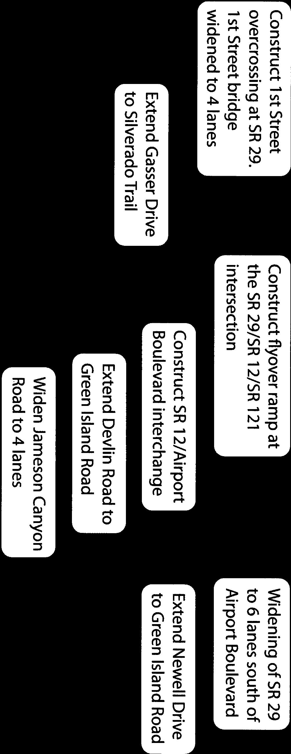
27 Existing Studies and Plans FUTURE ROADWAY IMPROVEMENTS The future roadway improvements currently planned for the corridor will alleviate specific bottlenecks at SR 29/SR 221 flyover and SR 29/Airport Boulevard interchange (see Figure 5: Planned Roadway Improvements). Roadways that can serve as parallel routes to Highway 29 are limited (see Figure 3: Existing Roadway and Planned Extensions). Parallel routes could help reduce traffic congestion on Highway 29 as an alternative for local traffic and some through trips. New parallel routes will be provided with the extensions of Devlin Road, Newell Drive, South Napa Junction Road, and Commerce Boulevard. Jameson Canyon Road (SR 12) also serves as an alternative route, and widening of this roadway to four lanes will be completed in Within the context of the entire study area, a comprehensive solution to corridor traffic has not yet been identified. Planned roadway improvements have not fully considered the role that parallel routes might play in reducing Highway 29 traffic congestion, nor do they factor ways to shift motorists into other modes or ways to encourage motorists to commute during non-peak hours. 23
28 Napa Gateway Highway 29 Corridor Improvement Plan This page intentionally left blank. 24


29
30 Napa Gateway Highway 29 Corridor Improvement Plan This page intentionally left blank. 26
31 Existing Studies and Plans POLICY CONTEXT For each jurisdiction or agency that would be affected by the Highway 29 Gateway Corridor Improvement Plan, planning and policy documents were reviewed to determine consistency or variation in visioning of the corridor. The various plans summarized below show a general consistency with improving the traffic congestion along the corridor while envisioning a more multimodal, complete streets network. Some variations include the City of American Canyon s plan to increase the number of travel lanes on Highway 29 to three in each direction within the City boundary, the Sonoma Boulevard Corridor Plan recommendation for lane reductions or road diets in certain segments in Vallejo, and Caltrans recommendation of maintaining Highway 29 as a four-lane highway. Caltrans Caltrans developed the Corridor Plan State Route 29 (2011), which provides recommendations for multi-modal operational strategies for this state highway. Some of the key roadway recommendations include: optimizing signal timing for throughput at a safe speed, increasing multimodal mode share in the full length of the corridor, study the concept of constructing an HOV lane from City of Napa to the Vallejo Ferry Terminal, and utilizing Intelligent Transportation Systems (ITS) as a key strategy for allowing throughput increases without adding lanes. The plan suggests some ITS strategies, including: increased driver information systems, advanced traffic signals, roadway and weather monitoring stations, highway advisory radio, closed circuit television cameras, and fiber optic communication. Implementing an HOV lane would require significant study and effort, and the Plan does not provide any additional detail regarding this recommendation. Vallejo The Sonoma Boulevard Corridor Design Plan (Draft 2012) Planning Area spans 5.5 miles between Curtola Parkway in the south and State Route 37 in the north. The plan details the general location of land uses, streetscape design concepts, and proposed circulation patterns for all modes of transportation along Sonoma Boulevard. Recommendations range along the corridor and include installation of bicycle lanes, reduction in automobile travel lanes or travel lane widths, street reconfigurations, and various land use development focuses. The Plan does not focus on vehicle operations or capacity increases. The Highway 29 Corridor Plan will not focus on the Vallejo area due to the recent detailed analysis completed for the Sonoma Boulevard Plan, except to consider transit connectivity with the Vallejo ferry terminal. City of American Canyon The American Canyon Draft Circulation Element (2012) update provides some specific policy guidance for Highway 29. The City plans to design the system to discourage regional traffic from bypassing Highway 29 and impacting local streets, while at the same time exploring a complete streets approach that will expand the travel capacity of the roadway. The major Highway 29 improvement is to widen the four-lane arterial to a six-lane arterial (from the southern to northern limits of the city). Other improvements include completion of parallel routes, including Devlin Road, Newell Drive, South Napa Junction Road, and Commerce Boulevard. 27
32 Napa Gateway Highway 29 Corridor Improvement Plan City of Napa The City of Napa General Plan (2011 update) has several major transportation objectives: develop a transportation infrastructure that provides for an acceptable traffic flow and provides access to all destinations, create a multi-modal citywide transportation system, and minimize the negative effects of additional automobile traffic and other transportation. The Plan has no specific emphasis on Highway 29, which functions as a freeway within the City. A parallel route improvement identified in the plan is the extension of Solano Avenue from Lincoln Street to 1st Street. Napa County In the Napa County General Plan Circulation Element (2008), the County seeks to provide a roadway system that maintains current roadway capacities in most locations and is both safe and efficient in terms of providing local access. The County also seeks to discourage increases in commuter traffic passing through the County on all roadways except I-80 by designing County roadways to meet local rather than regional needs and by supporting improvements to alternative facilities outside Napa County (e.g., State Route 37). The General Plan includes the following roadway improvements relevant to our study, including: widening of Jameson Canyon Road (SR12), interchange at the intersection of SR12, Airport Boulevard, and Highway 29, extension of Newell Road to Green Island Road, extension of Devlin Road between Soscol Ferry Road and Green Island Road, widen Highway 29 in American Canyon, and synchronize traffic signals along Highway 29 in American Canyon. 4.2 Public Transit EXISTING CHARACTER Some insights into the existing character and perceptions of Napa s transit service can be found in NCTPA s Short Range Transit Plan (SRTP) (2008). Transit riders in Napa seem to be chiefly persons who do not have access to personal vehicles and are dependent on public transit (such as low-income households and senior citizens). At workshops, community stakeholders have noted that Napa County residents are generally unaware of their transit options. Transit dependent populations know of the services out of necessity but people with access to vehicles do not know transit routes or how they can be accessed. Many cited that the transit service was inconvenient and inflexible. The main weaknesses noted by stakeholders include: lack of marketing, low community awareness, infrequent service, long travel time, poor on-time performance, and lack of passenger amenities. System-wide improvements, including system-wide service improvements and the opening of a new multi-modal transit center in downtown Napa, were completed in late EXISTING CONDITIONS Transit access along the Highway 29 corridor between Napa, American Canyon, and Vallejo is limited. The study area is served by VINE Transit, American Canyon Transit, and SolTrans (see Figure 6: Existing Transit Service). Only two regional routes provide mobility to transit customers in the study area, with just one operating on weekends (both routes are discussed below). 28
33 Existing Studies and Plans Providing useful and well utilized transit in an area with a suburban and rural character is challenging due to lack of direct connections, low service frequency, and lengthy trip times. VINE Route 11 provides local service between Napa and Vallejo Ferry Terminal via American Canyon and unincorporated Napa County. The route operates with 30 minute frequency during peak weekday hours and one hour frequency off-peak and on Saturday (the route does not run on Sunday). The one way travel time of about one hour and fifteen minutes between Napa and Vallejo make it difficult for bus service to compete with the automobile based on travel time, and even more so with potential customers with origins or destinations more than a ¼ mile walk from a bus stop. Prior to winter 2012, VINE Route 10 provided a continuous route from Calistoga to Vallejo. It has since been split into Routes 10 and 11. Historically, ridership on Route 10 show that morning and evening runs see an average occupancy of 35 to 50 percent. Midday ridership, with a lower number of runs, sees a higher ridership with average occupancy of 75 to 80 percent. VINE Route 29 is an express route that offers service between Calistoga and the El Cerrito Del Norte BART Station via Napa, American Canyon, and Vallejo. The route operates with four AM outbound and four PM inbound trips each weekday to/from BART. This route serves commuters but due to significant traffic congestion along the corridor reliability is a likely concern of many potential customers and thus attractiveness to choice riders is limited. The two routes that operate in American Canyon are deviated fixed route services, essentially meaning that they are lifeline services for seniors and disadvantaged populations. The City of Napa has several intercity routes that connect to the regional routes, however long headways (i.e. low frequencies) can be assumed to discourage ridership. 29
34 Napa Gateway Highway 29 Corridor Improvement Plan This page intentionally left blank. 30


35
36 Napa Gateway Highway 29 Corridor Improvement Plan This page intentionally left blank. 32
37 Existing Studies and Plans FUTURE IMPROVEMENTS In general, future public transit improvements discussed in plan documents are at the policy level rather than identifying specific route additions, changes, or improvements. For the American Canyon Circulation Element Update, the Plan discusses building a multi-modal transit center on Highway 29 within the designated Community Center or Town Center. In addition, it recommends providing transit linkages between the Community Center or Town Center and regionallyrelated transit such as BART, commuter railway and the Vallejo ferry. The NCTPA SRTP identifies some concepts such as addressing on-time performance and expanding service in the City of Napa and American Canyon. POLICY CONTEXT The plans summarized below show a consistent desire to expand and improve public transit, particularly by improving regional connections and emphasizing its use as an alternative to vehicle commute trips. Policies also emphasize the importance of funding improvements, but acknowledge limited funding options and generally avoid making specific recommendations. Caltrans In its Corridor Plan State Route 29 (2011), Caltrans makes transit recommendations that include: encouraging use of excess right-of-way for bus stops and park and ride facilities, increase the reliability and frequencies of existing public transit (particularly VINE route links to the Vallejo Ferry Terminal), upgrading mass transit services (consider lane additions, bus rapid transit, parallel routes in the southern county and Jameson Canyon), and promoting increased housing density and transit-oriented development along the corridor. The recommendation of an HOV lane (previously noted) was envisioned as a transit beneficial strategy. Vallejo As discussed in the Roadway section, the Sonoma Boulevard Corridor Design Plan (Draft 2012) details the general location of land uses, streetscape design concepts, and proposed circulation patterns for all modes of transportation along Sonoma Boulevard. City of American Canyon The American Canyon Draft Circulation Element (2012) provides policies to promote the use of public transportation and emphasizes continued collaboration with other agencies and jurisdictions to promote local and regional public transit. In terms of local transit, American Canyon calls for expanding and improving local transit operations, the City s demand-responsive transit system, and maintaining consistency with the NCTPA Congestion Management Plan. The Circulation Element does not provide any specifics on what the public transit expansions or improvements will be. 33
38 Napa Gateway Highway 29 Corridor Improvement Plan City of Napa The City of Napa General Plan (2011 update) has a public transit goal to develop and maintain an efficient and convenient transit system with connections to Napa County and the region. Some recommended performance targets include increasing transit mode split to five percent by 2020, locating bus routes within one quarter-mile of 85 percent of city residences (90 percent of city activity centers), and operating at half-hour intervals for 60 percent of bus routes. While Napa s General Plan recognizes the need to increase transit service to meet these targets, it acknowledges the lack of available public subsidies and conditions some transit policies on the availability of funding. Napa County In the Napa County General Plan Circulation Element (2008), the County is focusing on increasing the attractiveness and use of energy-efficient forms of transportation such as public transit, walking, and bicycling through a variety of means, including promoting transit-oriented development in existing municipalities and urbanized areas and the use of transit by visitors to Napa County. These general policy goals do not include specific actions. There is also emphasis on reducing the percentage of work trips that are by private, single-occupant vehicles by 2030 such that Napa County s percentage decreases to 50 percent. Some of the policies identified to help meet this goal include: working with NCTPA to conduct regular reviews of public transit use and opportunities for its expansion in Napa County and encouraging implementation of transportation demand management programs with the County of Napa and other major employers. The NCTPA Short Range Transit Plan (SRTP) (2008) presents service plan concepts but is careful not to label them as recommendations due to financial constraint concerns. Some of the key concepts include: discontinue Route 11 (as of January 2013, this route is being split with Route 10 as discussed earlier), address on-time performance, senior shuttle, expanded weekend and evening service in the City of Napa, increase service hours for American Canyon Transit, and increase marketing efforts. 4.3 Pedestrian and Bicycle Facilities EXISTING CHARACTER The county s mountains, valleys, and scenery attract recreational and tourist cyclists who are looking for a physically challenging and beautiful bicycle ride excursion. Along the corridor itself, the terrain is relatively flat and compact, characteristics that are optimal for inter-city commuting and intra-city utilitarian trips. Currently, inter-city travel on the valley floor via bicycle can be challenging because of limited paths, roads with high speed traffic, and geographic barriers including the Napa River. 34
39 Existing Studies and Plans EXISTING CONDITIONS There are no existing bicycle facilities that connect the entire length of the Highway 29 corridor, and there are few bicycle connections between cities (see Figure 7: Existing and Proposed Bicycle Facilities). Planned facilities such as the Vine and Bay Trails will greatly improve mobility for both experienced and casual cyclists. Some parallel routes are available to bicyclists, however. Currently, more experienced cyclists can travel on bicycle friendly roads that parallel Highway 29, such as Devlin Road, Golden Gate Road, and Foster Drive, however Highway 29 provides the only continuous connection between American Canyon and Napa and does not include bicycle facilities nor is it a safe or attractive roadway for bicycling due to high traffic volumes and travel speeds. 35
40
41
42 Napa Gateway Highway 29 Corridor Improvement Plan This page intentionally left blank. 38
43 Existing Studies and Plans FUTURE IMPROVEMENTS The Napa County Bicycle Plan (2012) recommends the following additions or improvements to interregional bicycle facilities: The Vine Trail, a continuous Class I multi-use path between the communities of Napa County and the Vallejo Ferry Terminal (running along Highway 29 in the City of Napa, then crossing the City to run east along the Napa River, and then continuing on Devlin Road into American Canyon to the Ferry Terminal); Class II Bike Lane along SR121 to SR221 to Highway 29 into American Canyon; Two parallel Class I multi-use paths parallel to Highway 29 from Unincorporated Napa County into American Canyon reconnecting to the proposed Vine Trail (along Airport Blvd and South Kelly Road); and Additional Class II and Class III bicycle facilities within the City of Napa and American Canyon which help close route gaps. Within American Canyon, future pedestrian improvements include pedestrian bridges at American Canyon Road, Donaldson Way, and Napa Junction Road. In Vallejo, the Sonoma Boulevard Corridor Plan continues the proposed Class II bike lane along Highway 29 to connect to the Vallejo Ferry Terminal. POLICY CONTEXT The various plans summarized below express a similar desire to expand and improve pedestrian and bicycle connections. References to specific locations for improvements are consistent since city bicycle plans were developed in coordination with the County of Napa. Caltrans In its Corridor Plan State Route 29 (2011), Caltrans made important bicycle and pedestrian recommendations including: constructing Class I multi-use paths on Highway 29 right-of-way, planning and constructing a network of bikeways connecting the Vallejo Ferry Terminal to just south to Calistoga, increasing sidewalk inventory on Highway 29, studying pedestrian overcrossings in American Canyon, increasing infill development, and recommending sidewalks, overcrossings, countdown signals, other pedestrian amenities where appropriate. Vallejo As discussed in the Roadway section, the Sonoma Boulevard Corridor Design Plan (Draft 2012) details the general location of land uses, streetscape design concepts, and proposed circulation patterns for all modes of transportation along Sonoma Boulevard. The Plan does provide some specific improvements for bicyclists and pedestrians. Continuous Class II bike lanes (northbound and southbound) are envisioned along the entire length of their study area from Curtola Parkway to Lewis Brown Drive just south of SR37. New sidewalks and sidewalk widening are proposed along several sections of the corridor. 39
44 Napa Gateway Highway 29 Corridor Improvement Plan City of American Canyon The American Canyon Draft Circulation Element (2012) contains high-level policies to promote walking and bicycling, meet the mobility needs of all users, and develop a safe and efficient nonmotorized circulation system. There is also a focus on maintaining and updating street standards that provide for Complete Streets. The Circulation Element generally does not discuss policies in detail but does provide a few specifics, including establishing a requirement for sidewalks on all arterial and collector streets and to develop and implement a pedestrian master plan. The local bicycle plan in American Canyon supplements and incorporates the Napa Countywide Bicycle Plan. See discussion below. City of Napa The City of Napa General Plan (2011 update) has a pedestrian services goal to provide an interconnected pedestrian network providing safe access between residential areas, public uses, shopping, and employment centers, with special attention to a high quality downtown pedestrian environment with links to neighborhoods. The local bicycle plan in the City of Napa supplements and incorporates the Napa Countywide Bicycle Plan. See discussion below. Napa County The NCTPA Countywide Bicycle Plan (2012) was developed in collaboration with all cities in the Napa County. The plan s objective is to establish a comprehensive, safe, connected countywide bicycle transportation and recreation system to support increases in bicycle trips made throughout the County to 10 percent of all trips by They intend to reach this goal by developing a local and countywide network connecting the communities, developing contiguous Class I pathways, and ensuring all transportation projects improve bicycle facilities. The Plan recommends the following additions or improvements that are described above within the subsection named Future Improvements. 40
45 Existing Studies and Plans 4.4 Matrix of Applicable Policies Policies with direct application to the Highway 29 corridor are summarized in the following matrix and provide an at-a-glance resource. The matrix will also help ensure that recommendations conform with existing policies, unless non-conforming recommendations are critical to attaining corridor objectives. If recommendations do not conform, a clear rationale will be provided and policy language may be suggested to reconcile differences. 41
46 Napa Gateway Highway 29 Corridor Improvement Plan This page intentionally left blank. 42
47 Existing Studies and Plans Roadway POLICIES Specific VALLEJO AMERICAN CANYON CITY OF NAPA COUNTY AND OTHER Sonoma Blvd Corridor Design Plan DRAFT (2012) Draft Circulation Element (2012) GP (2011 update) Napa County GP Circulation Element (2008) Corridor Plan SR29 (Caltrans, 2011) NCTPA Short Range Transit Plan (2008) NCTPA Countywide Bike Plan (2012) Reduction in automobile travel lanes or travel lane widths south of SR37 Roadway improvements relevant to our study, Optimize signal timing for throughput at a safe speed Widen the SR29 four lane arterial to a six lane arterial (from the southern to northern limits of the City) Parallel route improvement extension of Solano Avenue from Lincoln Street to 1st Street (west of SR29) including: widen Jameson Canyon Road (SR12), interchange at the intersection of SR12, Airport Boulevard, and SR29, extension of Newell Road to Green Island Road, extension of Devlin Road between Soscol Ferry Road and Green Island Road, widen SR29 in American Canyon, and synchronize traffic signals along SR29 in American Canyon. Noted Conflicts Some variations include the City of American Canyon s plan to increase the number of travel lanes on SR29 to three in each direction within the City boundary, the Sonoma Boulevard Corridor Plan recommendation for lane reductions or road diets in certain segments in Vallejo, and Caltrans recommendation of maintaining SR29 as a four lane highway. Street reconfigurations Various land use development focuses Completion of parallel routes, including Devlin Road, Newell Drive, South Napa Junction Road, and Commerce Boulevard Study the concept of constructing an HOV lane from City of Napa to the Vallejo Ferry Terminal Utilize ITS as a key strategy for allowing throughput increases without adding lanes, including: increased driver information systems, advanced traffic signals, roadway and weather monitoring stations, highway advisory radio, closed circuit television cameras, and fiberoptic communication. General Design circulation system to discourage regional traffic from bypassing SR29 and impacting City streets. Develop a transportation infrastructure Provide a roadway system that maintains current that provides for an acceptable traffic roadway capacities in most locations and is both flow and provides access to all safe and efficient in terms of providing local access destinations General consistency with improving the traffic congestion along the corridor while envisioning a more multi modal, complete streets network. Explore a complete streets approach that will expand the travel capacity of SR29 Maintain and update street standards that provide for Complete Streets. Minimize the negative effects of Discourage increases in commuter traffic passing additional automobile traffic and other through the county on all roadways except I 80 by transportation designing county roadways to meet local rather than regional needs and by supporting improvements to alternative facilities outside the County (e.g., State Route 37) Transit Specific Transit amenities (e.g. bus shelters) along the corridor. Build multi modal transit center on SR29 within the designated Community Center or Town Center The recommendation of an HOV lane (previously noted) was envisioned as a transit beneficial strategy. Discontinue Route 11 (as of January 2013, this route is being split with Route 10) No inconsistencies Transit oriented development node at Sonoma Blvd/Couch/railroad tracks General Provide transit linkages between the Develop and maintain an efficient and Community Center or Town Center convenient transit system with and regionally related transit such as connections to Napa County and the BART, commuter railway and the region Vallejo ferry Continued collaboration with other agencies and jurisdictions to promote local and regional public transit. Increase transit mode split to five percent by 2020 Expand and improve local transit Locate bus routes within ¼ mile of 85 operations, the City s demandresponsive transit system, and of city activity centers) percent of city residences (90 percent maintaining consistency with the NCTPA Congestion Management Plan Promote the use of transit by visitors to Napa County. Encourage use of excess right of way (ROW) for bus stops and Park & Ride facilities Expanded weekend and evening service in the City of Napa, increase service hours for American Canyon Transit Work with NCTPA to conduct regular reviews of Increase the reliability and frequencies of Address on time performance public transit use and opportunities for its expansion existing public transit (particularly VINE route in Napa County links to the Vallejo Ferry Terminal) Upgrade mass transit services (consider lane additions, bus rapid transit, parallel routes in the southern county and Jameson Canyon) The various plans show consistency with expressing the desire to expand and improve public transit, particularly emphasizing improving regional connections and utilizing public transit to reduce vehicle commute trips. The plans also emphasize the lack of funding available for improvements and tend to avoid making any specific recommendations. Operate at half hour intervals for 60 percent of bus routes 43
CITY OF COCOA BEACH 2025 COMPREHENSIVE PLAN. Section VIII Mobility Element Goals, Objectives, and Policies
 CITY OF COCOA BEACH 2025 COMPREHENSIVE PLAN Section VIII Mobility Element Goals, Objectives, and Policies Adopted August 6, 2015 by Ordinance No. 1591 VIII MOBILITY ELEMENT Table of Contents Page Number
Napa County Transportation and Planning Agency. Project Introduction
 Napa County Transportation and Planning Agency HIGHWAY 29 GATEWAY CORRIDOR IMPROVEMENT PLAN CITIZENS ADVISORY COMMITTEE Project Introduction Prepared by: Dyett & Bhatia In association with: Fehr & Peers
Transportation Master Plan Advisory Task Force
 Transportation Master Plan Advisory Task Force Network Alternatives & Phasing Strategy February 2016 BACKGROUND Table of Contents BACKGROUND Purpose & Introduction 2 Linking the TMP to Key Council Approved
Chapter 7. Transportation. Transportation Road Network Plan Transit Cyclists Pedestrians Multi-Use and Equestrian Trails
 Chapter 7 Transportation Transportation Road Network Plan Transit Cyclists Pedestrians Multi-Use and Equestrian Trails 7.1 TRANSPORTATION BACKGROUND The District of Maple Ridge faces a number of unique
North Coast Corridor:
 North Coast Corridor: Connecting People, Transportation & Environment Legislative Hearing: 11.8.10 1 North Coast Corridor Region s Lifeline A Regional Strategy Mobility, Economy & Environment North Coast
Berkeley Strategic Transportation Plan A-76
 Berkeley Strategic Transportation Plan A-76 Appendices 1. A Team Effort 2. Where We ve Been A-11 Berkeley Strategic Transportation Plan Alameda County Transportation Plan Alameda County will be served
CONNECTING PEOPLE TO PLACES
 CONNECTING PEOPLE TO PLACES 82 EAST BENCH MASTER PLAN 07 Introduction The East Bench transportation system is a collection of slow moving, treelined residential streets and major arteries that are the
Solana Beach Comprehensive Active Transportation Strategy (CATS)
") Solana Beach Comprehensive Active Transportation Strategy (CATS) 3.0 Goals & Policies The Solana Beach CATS goals and objectives outlined below were largely drawn from the Solana Beach Circulation Element
Solana Beach Comprehensive Active Transportation Strategy (CATS) 3.0 Goals & Policies The Solana Beach CATS goals and objectives outlined below were largely drawn from the Solana Beach Circulation Element
Exhibit 1 PLANNING COMMISSION AGENDA ITEM
 Exhibit 1 PLANNING COMMISSION AGENDA ITEM Project Name: Grand Junction Circulation Plan Grand Junction Complete Streets Policy Applicant: City of Grand Junction Representative: David Thornton Address:
ACTIVE TRANSPORTATION
 ACTIVE TRANSPORTATION Mobility 2040 Supported Goals Improve the availability of transportation options for people and goods. Support travel efficiency measures and system enhancements targeted at congestion
Purpose and Need. Chapter Introduction. 2.2 Project Purpose and Need Project Purpose Project Need
 Chapter 2 Purpose and Need 2.1 Introduction The El Camino Real Bus Rapid Transit (BRT) Project (Project) would make transit and other transportation improvements along a 17.6-mile segment of the El Camino
Executive Summary Route 30 Corridor Master Plan
 Route Corridor Master Plan Project Overview The Route Corridor Master Plan is a coordinated multimodal transportation and land use plan for the entire stretch of Route through East Whiteland Township,
Circulation in Elk Grove includes: Motor vehicles, including cars and trucks
 Circulation, as it is used in this General Plan, refers to the many ways people and goods move from place to place in Elk Grove and the region. Circulation in Elk Grove includes: Motor vehicles, including
Perryville TOD and Greenway Plan
 Perryville TOD and Greenway Plan Greenway Glossary Pathway: A bicycle and pedestrian path separated from motorized vehicular traffic by an open space, barrier or curb. Multi-use paths may be within the
o n - m o t o r i z e d transportation is an overlooked element that can greatly enhance the overall quality of life for the community s residents.
 N o n - m o t o r i z e d transportation is an overlooked element that can greatly enhance the overall quality of life for the community s residents. 84 Transportation CHAPTER 11 INTRODUCTION Transportation
2.0 Existing Conditions
 20 2.0 Existing Conditions 2.1 Land Use, Future Growth Patterns, Physical Barriers Geographic Overview Sutter County s land use pattern is characterized by extensive agricultural areas, significant natural
Clackamas County Comprehensive Plan
 ROADWAYS The County s road system permits the movement of goods and people between communities and regions, using any of a variety of modes of travel. Roads provide access to virtually all property. They
summary of issues and opportunities
 1 summary of issues and opportunities EXECUTIVE SUMMARY CHAPTER 2: HISTORY - 3: LAND USE This first chapter is an overview of lessons learned from analysis of the existing conditions on El Camino as well
MCTC 2018 RTP SCS and Madera County RIFP Multi-Modal Project Eval Criteria GV13.xlsx
 MCTC 8 RTP SCS and Madera County RIFP Multi-Modal Project Eval Criteria GV.xlsx Madera County Transportation Commission Regional Transportation Plan / Sustainable Communities Strategy Multi-Modal Project
Goal 3: Foster an environment of partnerships and collaboration to connect our communities and regions to one another.
 Non-Motorized Transportation Plan (NMTP) Draft Vision, Goal and,, Tri-County Regional Planning Commission (TCRPC) Purpose The purpose of the Tri-County Regional Planning Commission (TCRPC) Non-Motorized
2. Context. Existing framework. The context. The challenge. Transport Strategy
 Transport Strategy Providing quality connections Contents 1. Introduction 2. Context 3. Long-term direction 4. Three-year priorities 5. Strategy tree Wellington City Council July 2006 1. Introduction Wellington
NM-POLICY 1: Improve service levels, participation, and options for non-motorized transportation modes throughout the County.
 Transportation PRINCE WILLIAM COUNTY 2008 COMPREHENSIVE PLAN NON-MOTORIZED PLAN CONTENTS Goals, Policies, and Action Strategies Table 4 (Bike Facility Classifications and Descriptions) Table 5 (Bike Facility
Regional Transportation Needs Within Southeastern Wisconsin
 Regional Transportation Needs Within Southeastern Wisconsin #118274 May 24, 2006 1 Introduction The Southeastern Wisconsin Regional Planning Commission (SEWRPC) is the official areawide planning agency
4. ENVIRONMENTAL IMPACT ANALYSIS 9. TRANSPORTATION AND TRAFFIC
 4. ENVIRONMENTAL IMPACT ANALYSIS 9. TRANSPORTATION AND TRAFFIC 4.9.1 INTRODUCTION The following section addresses the Proposed Project s impact on transportation and traffic based on the Traffic Study
Develop a Multi-Modal Transportation Strategy (Theme 6)
") DEVELOP A MULTI-MODAL TRANSPORTATION STRATEGY (THEME 6) WHY IS THIS THEME ADDRESSED? Develop a Multi-Modal Transportation Strategy (Theme 6) Statement of Ideal Reduce resident and visitor reliance on single
DEVELOP A MULTI-MODAL TRANSPORTATION STRATEGY (THEME 6) WHY IS THIS THEME ADDRESSED? Develop a Multi-Modal Transportation Strategy (Theme 6) Statement of Ideal Reduce resident and visitor reliance on single
Living Streets Policy
 Living Streets Policy Introduction Living streets balance the needs of motorists, bicyclists, pedestrians and transit riders in ways that promote safety and convenience, enhance community identity, create
Proposed. City of Grand Junction Complete Streets Policy. Exhibit 10
 Proposed City of Grand Junction Complete Streets Policy Exhibit 10 1 City of Grand Junction Complete Streets Policy Vision: The Complete Streets Vision is to develop a safe, efficient, and reliable travel
Basalt Creek Transportation Refinement Plan Recommendations
 Basalt Creek Transportation Refinement Plan Recommendations Introduction The Basalt Creek transportation planning effort analyzed future transportation conditions and evaluated alternative strategies for
SANTA MONICA BOULEVARD CORRIDOR
 CIRCULATION ELEMENT WHITE PAPER NO. 3 SANTA MONICA BOULEVARD CORRIDOR INTRODUCTION From the 1930s to the beginning of Los Angeles freeway era, Santa Monica Boulevard, (previously Route 66, the Beverly
PEDESTRIAN ACTION PLAN
 ATTACHMENT 2 CITY OF SANTA MONICA PEDESTRIAN ACTION PLAN CITY OF SANTA MONICA PEDESTRIAN ACTION PLAN This page intentionally left blank EXECUTIVE SUMMARY CHAPTER 1 EXECUTIVE SUMMARY Setting the Stage
SETTINGS AND OPPORTUNITIES MOBILITY & ACCESS
 7 mobility & access how do people use el camino what is it like to drive on el camino/to park along el camino what is the pedestrian experience like what is the role of transit along the corridor what
Vision: Traditional hamlet with an attractive business/pedestrian friendly main street connected to adjacent walkable neighborhoods
 N D. Focus Area II Vision: Traditional hamlet with an attractive business/pedestrian friendly main street connected to adjacent walkable neighborhoods Transit Road Focus Area II is located in the Hamlet
Classification Criteria
 SCHEDULE D TO RECOMMENDED OFFICIAL PLAN AMENDMENT NO. 40 SCHEDULE C-4 Road Criteria Criteria Traffic Service Objective Land Service/Access Typical Daily Traffic Volume Flow characteristics Travel Speed
San Jose Transportation Policy
 San Jose Transportation Policy Protected Intersections in LOS Policies to Support Smart Growth Presented by: Manuel Pineda City of San Jose Department of Transportation Bay Area Map San Francisco Oakland
Chapter 5 Future Transportation
 Chapter 5 Future Transportation The Future Land Use Plan identifies the desired land use designations. The land uses desired for Crozet depend, in large part, on the success of the transportation system,
CITY OF BLOOMINGTON COMPLETE STREETS POLICY
 CITY OF BLOOMINGTON COMPLETE STREETS POLICY POLICY OBJECTIVE: The City of Bloomington will enhance safety, mobility, accessibility and convenience for transportation network users of all ages and abilities,
Sixth Line Development - Transit Facilities Plan
 Memorandum Date: November 13, 2012 To: From: c.c. Subject: Rob Freeman (Freeman Planning) Kevin Phillips Sixth Line Development - Transit Facilities Plan 33016631 This memo was prepared to review the transit
Chapter 6 Transportation Plan
 Chapter 6 Transportation Plan Transportation Plan Introduction Chapter 6 Transportation Plan Transportation Plan Introduction This chapter describes the components of Arvada s transportation system, comprised
CIty of AMERICAN CANYON
 CIty of AMERICAN CANYON CIRCULATION ELEMENT VISION The City of American Canyon (City) is a community that embraces mobility through the use of all transportation modes. This Element is correlated to land
WELCOME TO OPEN HOUSE # 1 June 14, 2017
 Langstaff Road Weston Road to Highway 7 Class Environmental Assessment Study WELCOME TO OPEN HOUSE # 1 June 14, 2017 Please sign in and join our mailing list Purpose of Open House #1 & Study Area York
San Mateo County Comprehensive Bicycle and Pedestrian Plan Open House
 San Mateo County Comprehensive Bicycle and Pedestrian Plan Open House October 28, 2010 Presented to San Mateo County residents and interested parties by Lauren Ledbetter, Alta Planning + Design Matt Haynes,
Welcome. Background. Goals. Vision
 Welcome The formal Public Information Centre (PIC) for the Transportation Master Plan How We GO will be held in early 2017. At that time we will present the recommended transportation system for Niagara
Bicycle Master Plan Goals, Strategies, and Policies
 Bicycle Master Plan Goals, Strategies, and Policies Mobilizing 5 This chapter outlines the overarching goals, action statements, and action items Long Beach will take in order to achieve its vision of
TRANSPORTATION TRAINING TOPICS. April 6, 2010
 TRANSPORTATION TRAINING TOPICS April 6, 2010 Roles of Transportation Providers Context and Policy Makers Division of Transportation and Traffic Other City Operations Other Transportation Operators CMA
South King County High-Capacity Transit Corridor Study
 HIGH-CAPACITY TRANSIT CORRIDOR STUDY South King County Corridor South King County High-Capacity Transit Corridor Study Corridor Report August 2014 South King County High Capacity Transit Corridor Report
Corpus Christi Metropolitan Transportation Plan Fiscal Year Introduction:
 Introduction: The Safe, Accountable, Flexible, Efficient Transportation Equity Act: A Legacy for Users (SAFETEA-LU) has continued the efforts started through the Intermodal Surface Transportation Efficiency
City of Novi Non-Motorized Master Plan 2011 Executive Summary
 City of Novi Non-Motorized Master Plan 2011 Executive Summary Prepared by: February 28, 2011 Why Plan? Encouraging healthy, active lifestyles through pathway and sidewalk connectivity has been a focus
Access BART: TOD and Improved Connections. October 29, 2008
 Access BART: TOD and Improved Connections October 29, 2008 1 Access BART Study Goals Evaluate at the system-level land use and access scenarios to optimize ridership Identify station clusters that provide
SANTA CLARA COUNTYWIDE BICYCLE PLAN August 2008
 SANTA CLARA COUNTYWIDE BICYCLE PLAN August 2008 To assist VTA and Member Agencies in the planning, development and programming of bicycle improvements in Santa Clara County. Vision Statement To establish,
C C C
 C-012-001 Thank you for your support for the creation of new public space and nonmotorized access between downtown and the waterfront through the Overlook Walk, the East-West Connections, and the Promenade.
Highway 217 Corridor Study. Phase I Overview Report
 Highway 217 Corridor Study Phase I Overview Report November 3, 24 BACKGROUND AND OVERVIEW Study purpose The Highway 217 Corridor Study is developing multi-modal transportation solutions for traffic problems
City of Wayzata Comprehensive Plan 2030 Transportation Chapter: Appendix A
 A1. Functional Classification Table A-1 illustrates the Metropolitan Council s detailed criteria established for the functional classification of roadways within the Twin Cities Metropolitan Area. Table
2.0 Ballpark District
 2.0 Ballpark District 2.1 Introduction The Ballpark District is located in the south central portion of the City of Lake Elsinore, just north of the City limit line in this area. The Ballpark District
4 MOBILITY PLAN. Mobility Plan Objectives. Mobility Context. 1. Integrate with Local and Regional Transit Improvements
 Harbor Mixed Use CHAPTER Transit Corridor 4: Mobility Plan 4 MOBILITY PLAN Mobility Plan Objectives The Harbor Corridor Plan seeks to expand and improve the ways that people move along and through the
SECTION 1 - TRAFFIC PLANNING
 SECTION 1 - TRAFFIC PLANNING 1.1 TRAFFIC OPERATIONS 1.1.1 Roadway Functional Classification The Multnomah County Comprehensive Framework Plan s Policy 34: Trafficways and the Functional Classification
Corporate. Report COUNCIL DATE: June 26, 2006 NO: C012 COUNCIL-IN-COMMITTEE. TO: Mayor & Council DATE: June 22, 2006
 Corporate NO: C012 Report COUNCIL DATE: June 26, 2006 COUNCIL-IN-COMMITTEE TO: Mayor & Council DATE: June 22, 2006 FROM: General Manager, Engineering FILE: 0410-20(MoT/Gate) SUBJECT: Surrey Response on
Chapter 4. Circulation
 Chapter 4. Circulation As a neighborhood, the Broadway District can support multiple mobility options such as enhanced pedestrian and bicycle pathways and greater transit access. The Broadway District
Route 7 Corridor Study
 Route 7 Corridor Study Executive Summary Study Area The following report analyzes a segment of the Virginia State Route 7 corridor. The corridor study area, spanning over 5 miles in length, is a multi
5 CIRCULATION AND STREET DESIGN
 5 CIRCULATION AND STREET DESIGN This chapter describes circulation and streetscape improvements proposed for the Northwest Chico Specific Plan Area. It includes detailed design specifications for existing
MOUNTAIN HOUSE SPECIFIC PLAN I 9.1 INTRODUCTION ASSUMPTIONS TRANSPORTATION FACILITIES TRANSPORTATION IMPROVEMENTS PHASING 9.
 CHAPTER NINE: TRANSPORTATION AND CIRCULATION 9.1 INTRODUCTION 9.1 9.2 ASSUMPTIONS 9.1 9.3 TRANSPORTATION FACILITIES 9.1 9.4 TRANSPORTATION IMPROVEMENTS PHASING 9.3 LIST OF FIGURES LIST OF TABLES Figure
EXECUTIVE SUMMARY. Vision
 Vision Walking and bicycling in Salt Lake City will be safe, convenient, comfortable, and viable transportation options that connect people to places, foster recreational and economic development opportunities,
Multimodal Through Corridors and Placemaking Corridors
 68 Multimodal Through Corridors and Placemaking Corridors Corridors have different functions in a region. Some corridors are used to get smoothly and rapidly through a region or to get quickly to major
East Burke Transportation, Safety and Capacity Improvements
 East Burke Transportation, Safety and Capacity Improvements The purpose of this project is to increase mobility and improve safety for pedestrians, cyclists, and motor vehicles along VT Route 114 in the
Vision to Action Community Coalition February 14, 2014 Briefing
 Vision to Action Community Coalition February 14, 2014 Briefing Transportation and Transit Planning & Mass Transit Operations Strategic Growth Area Office Brian S. Solis Transportation & Transit Manager
Bicycle and Pedestrian Advisory Committee (BPAC) November 21, 2013
 November 21, 2013") Bicycle and Pedestrian Advisory Committee (BPAC) November 21, 2013 OVERALL LAND USE CONCEPT Overall Broadway Valdez District: 95.5 acres (35.1 acres right-of ways + 60.4 acres developable land) Plan Subareas:
Bicycle and Pedestrian Advisory Committee (BPAC) November 21, 2013 OVERALL LAND USE CONCEPT Overall Broadway Valdez District: 95.5 acres (35.1 acres right-of ways + 60.4 acres developable land) Plan Subareas:
ACTIVE TRANSPORTATION/NONMOTORIZED TRANSPORTATION
 ACTIVE TRANSPORTATION/NONMOTORIZED TRANSPORTATION BACKGROUND Active transportation, also known as nonmotorized transportation, is increasingly recognized as an important consideration when planning and
RESOLUTION NO ?? A RESOLUTION OF THE CITY OF NEPTUNE BEACH ADOPTING A COMPLETE STREETS POLICY
 RESOLUTION NO. 2018-?? A RESOLUTION OF THE CITY OF NEPTUNE BEACH ADOPTING A COMPLETE STREETS POLICY WHEREAS, safe, convenient, and accessible transportation for all users is a priority of the City of Neptune
Magnolia Place. Traffic Impact Analysis. Prepared for: City of San Mateo. Prepared by: Hexagon Transportation Consultants, Inc.
 Magnolia Place Traffic Impact Analysis Prepared for: City of San Mateo Prepared by: Hexagon Transportation Consultants, Inc. Updated January 4, 2010 Table of Contents 1. Introduction...1 2. Existing Conditions...6
FOR INFORMATION ONLY
 9 Date: August 6, 2012 Current Meeting: August 16, 2012 Board Meeting: September 6, 2012 BOARD MEMORANDUM TO: THROUGH: FROM: SUBJECT: Santa Clara Valley Transportation Authority Congestion Management Program
TRANSPORTATION NEEDS ASSESSMENT
 TRANSPORTATION NEEDS ASSESSMENT A travel demand analysis was carried out to determine the operational issues and the potential benefit that adding traffic capacity would have on the road network. All the
Main-McVay Transit Study: Phase 2 Options Definition and High Level Constraints Evaluation
 Main-McVay Transit Study: Phase 2 Options Definition and High Level Constraints Evaluation APRIL 2016 A collaborative study between: For Additional Information or to Comment If you would like additional
Omaha s Complete Streets Policy
 Omaha s Complete Streets Policy (Adopted August 2015) VISION To create great places and enhance our quality of life, the City of Omaha will provide safe, accessible streets for all users. Complete Streets
The Route 29 Corridor Study was initiated at the request of Virginia s Commonwealth
 CHAPTER 2: Study Background and approach The Route 29 Corridor Study was initiated at the request of Virginia s Commonwealth Transportation Board in response to requests from members of the General Assembly
Chapter 3: Multi-Modal Circulation and Streetscapes
 CHAPTER 3: MULTI-MODAL CIRCULATION AND STREETSCAPES Chapter 3: Multi-Modal Circulation and Streetscapes Overview Streetscape improvements have already been completed for Depot Street between Main Avenue
TRANSIT & NON-MOTORIZED PLAN DRAFT FINAL REPORT Butte County Association of Governments
 1 INTRODUCTION Maintaining a high quality of life is the essence of this plan for transit and non-motorized transportation in Butte County. Curbing greenhouse gas emissions (GHG) by reducing congestion,
Corridor Advisory Group and Task Force Meeting #10. July 27, 2011
 Corridor Advisory Group and Task Force Meeting #10 July 27, 2011 1 Agenda Recap CAG/TF #9 Public Meeting #2 Summary Single Mode Alternatives Evaluation Results Next Steps 2 3 CAG/TF #9 Recap CAG /TF #9
City Council Agenda Item #6-A CITY OF ALAMEDA Memorandum. To: Honorable Mayor and Members of the City Council. John A. Russo City Manager
 CITY OF ALAMEDA Memorandum To: From: Honorable Mayor and Members of the City Council John A. Russo City Manager Date: January 14, 2013 Re: Adopt a Resolution Approving a Complete Streets Policy, in Accordance
EXECUTIVE SUMMARY... vii 1 STUDY OVERVIEW Study Scope Study Area Study Objectives
 Contents EXECUTIVE SUMMARY... vii 1 STUDY OVERVIEW... 1-1 1.1 Study Scope... 1-1 1.2 Study Area... 1-1 1.3 Study Objectives... 1-3 2 EXISTING CONDITIONS... 2-1 2.1 Existing Freeway Conditions... 2-4 2.1.1
Portland International Airport Bicycle and Pedestrian Plan (October 2003) Staff Acknowledgements
 Staff Acknowledgements") Portland International Airport Bicycle and Pedestrian Plan (October 2003) Staff Acknowledgements Scott King, Senior Aviation Planner Jason Gately, Senior Aviation Planner Preston Beck, Associate Planner
Portland International Airport Bicycle and Pedestrian Plan (October 2003) Staff Acknowledgements Scott King, Senior Aviation Planner Jason Gately, Senior Aviation Planner Preston Beck, Associate Planner
Richmond Connects Visioning Update
 Richmond Connects Visioning Update To date there have been four elements of the visioning process: Vision20 Night at Byrd Theatre on May 3rd Advisory Committee Meeting on May 12 th Public Visioning Workshop
Bike San Mateo County San Mateo County Bicycle Plan Recommendations August 30, 2010
 Policy and Procedures Develop and Implement a Complete Streets Policy to comply with DD-64-R1 and AB1358 Commencing January 1, 2011, AB1358 requires that the legislative body of a city or county, upon
Memorandum. Fund Allocation Fund Programming Policy/Legislation Plan/Study Capital Project Oversight/Delivery Budget/Finance Contract/Agreement Other:
 Memorandum Date: November 20, 2017 To: Transportation Authority Board From: Eric Cordoba Deputy Director Capital Projects Subject: 12/5/17 Board Meeting: San Francisco Freeway Corridor Management Study
FROM: CITY MANAGER DEPARTMENT: PLANNING AND COMMUNITY ENVIRONMENT DATE: OCTOBER 4, 2004 CMR:432:04
 TO: HONORABLE CITY COUNCIL FROM: CITY MANAGER DEPARTMENT: PLANNING AND COMMUNITY ENVIRONMENT DATE: OCTOBER 4, 2004 CMR:432:04 SUBJECT: FINANCE COMMITTEE RECOMMENDATION TO ADOPT TRANSPORTATION STRATEGIC
TRANSPORTATION & MOBILITY
 TRANSPORTATION & MOBILITY ROADWAY SYSTEM There are approximately 40 miles of roadways in Manitou Springs. For planning purposes, roadways are typically assigned a functional classification which defines
21.07 TRANSPORT CONNECTIVITY AND INFRASTRUCTURE
 21.07 TRANSPORT CONNECTIVITY AND INFRASTRUCTURE 21.07-1 Connectivity and Choice Transport connectivity and mode choice are critical to achieving productive, sustainable and socially just cities. Travel
STONY PLAIN ROAD STREETSCAPE
 Jasper Place Revitalization Strategy: Vision The people involved in the Jasper Place Revitalization Strategy envision: Goal 1: Feeling safe in our community Create a community where feeling safe is common--where
Chapter 2. Bellingham Bicycle Master Plan Chapter 2: Policies and Actions
 Chapter 2 Bellingham Bicycle Master Plan Chapter 2: Policies and Actions Chapter 2: Policies and Actions The Bicycle Master Plan provides a road map for making bicycling in Bellingham a viable transportation
TABLE OF CONTENTS. Executive Summary
 Executive Summary Background... ES-1 Pedestrian Network... ES-2 Bikeway Network... ES-2 Collision History... ES-2 Public Input... ES-4 Conclusions and Recommendations... ES-4 1. Introduction and Setting
ROUTES 55 / 42 / 676 BUS RAPID TRANSIT LOCALLY PREFERRED ALTERNATIVE
 ROUTES 55 / 42 / 676 BUS RAPID TRANSIT LOCALLY PREFERRED ALTERNATIVE April, 2012 1 INTRODUCTION The need for transit service improvements in the Routes 42/55/676 corridor was identified during the Southern
Prepared For: Shieldbay Developments Inc. c/o Matson, McConnell Ltd. 2430A Bloor Street West Toronto, Ontario M6S 1P9.
 Prepared For: Shieldbay Developments Inc. c/o Matson, McConnell Ltd. 2430A Bloor Street West Toronto, Ontario M6S 1P9 Prepared By: URS Canada Inc. 4 th Floor, 30 Leek Crescent Richmond Hill, Ontario L4B
AMATS Complete Streets Policy
 AMATS Complete Streets Policy Table of Contents: Section 1. Definition of Complete Streets Section 2. Principles of Complete Streets Section 3. Complete Streets Policy Section 4. Consistency Section 5.
3.11 Transportation Environmental Setting. Roadway Network. Regional Facilities
 City of American Canyon Napa Airport Corporate Center Project Transportation 3.11 Transportation This section describes the existing transportation setting and potential effects from project implementation
EXECUTIVE SUMMARY: TRANSIT-ORIENTED DEVELOPMENT IN SMITHS FALLS, ONTARIO; A COMPARISON BETWEEN TWO SITES
 EECUTIVE SUMMARY: TRANSIT-ORIENTED DEVELOPMENT IN SMITHS FALLS, ONTARIO; A COMPARISON BETWEEN TWO SITES Topic and Purpose In 2007, the Mayor of Ottawa s Task Force on Transportation suggested adding a
Appendix A-1: Purpose and Need Statement
 Appendix A-1: Purpose and Need Statement PURPOSE AND NEED STATEMENT Western & Ashland Corridors Bus Rapid Transit (BRT) Project Prepared for Chicago Transit Authority 567 West Lake Street Chicago, IL 60661
Environmental Assessment Findings & Recommendations. Public Hearing November 13, 2014
 Environmental Assessment Findings & Recommendations Public Hearing November 13, 2014 Welcome! Welcome and Introductions Project and Environmental Assessment Overview Public Comments Adjourn Purpose of
EXECUTIVE SUMMARY OF CALEDON TRANSPORTATION NEEDS STUDY
 EXECUTIVE SUMMARY OF CALEDON TRANSPORTATION NEEDS STUDY The Caledon Transportation Needs Study has been undertaken as a joint project by the Town of Caledon and the Region of Peel to determine the existing
Typical Rush Hour Commute. PennyforTransportation.com
 Typical Rush Hour Commute In the News Overview of the Plan Collaborative plan with projects in every community Prioritizing connectivity and congestion relief Dedicated transportation-specific funding;
A CHANGING CITY. of Edmonton, it is essential that it reflects the long-term vision of the City.
 A CHANGING CITY By the year 2040, Edmonton will be home to more than 1 million people. To accommodate growth and support a healthy and compact city, we need a new approach to development/redevelopment
I-105 Corridor Sustainability Study (CSS)
") I-105 Corridor Sustainability Study (CSS) Metro Streets and Freeways Subcommittee March 21, 2019 Gary Hamrick Cambridge Systematics, Inc. I-105 CSS Project History & Background Funded by Caltrans Sustainable
I-105 Corridor Sustainability Study (CSS) Metro Streets and Freeways Subcommittee March 21, 2019 Gary Hamrick Cambridge Systematics, Inc. I-105 CSS Project History & Background Funded by Caltrans Sustainable
General Plan Circulation Element Update Scoping Meeting April 16, 2014 Santa Ana Senior Center, 424 W. 3rd Street, Santa Ana, CA 92701
 General Plan Circulation Element Update Scoping Meeting April 16, 2014 Santa Ana Senior Center, 424 W. 3rd Street, Santa Ana, CA 92701 Meeting Agenda 1. Purpose of Scoping Meeting 2. Project Overview 3.