CITY OF PARK RIDGE BICYCLE PLAN
|
|
|
- Pierce Hoover
- 5 years ago
- Views:
Transcription


1 CTY OF PARK RDGE BCYCLE PLAN February 2018 Updated November 2018 City of Park Ridge 505 Butler Place Park Ridge, L Prepared By: Ride llinois and Active Transportation Alliance
2 Table of Contents 1 ntroduction/ Executive Summary 1 2 Bikeway Types in the Park Ridge Plan 3 Standards and Guidelines 3 Bike Network Wayfinding Signage 3 Trails 4 Sidepaths and Sidewalks 4 On-Road Bikeways 6 Bike Lanes 6 Shared Lane Markings 8 Signed Bike Routes 8 Combined Bike/Parking Lanes 9 Three-Foot Law Signage 9 Signal Activation by Bikes 10 mproving Unsignalized Crossings 10 3 Guidelines for Bikeway Recommendations 12 Guiding Principles and Selecting Bikeway Type 13 Generating Public Support 14 4 Bicycle Crash Analysis 15 5 Bikeway Network Recommendations 18 Understanding the Maps 18 Understanding the Project List 25 Miscellaneous 35 6 Other Recommendations 36 Bicycle Parking 36 Education 37 Enforcement 39 Encouragement 40 7 Plan mplementation 41 Bike/Ped Advisory Commission & Coordinator 41 Multi-Year Work Plan 42 mplementation Funding 42 Technical Resources and Training 43 Bicycle Friendly Community Designation 44 Annual Evaluation 45 Appendices 46 1 Bike Task Force and Staff 46 2 Road Segment Data 47 3 Summary of Major Funding Sources 56 4 Building Blocks of a BFC 59
3 1 ntroduction/executive Summary Biking is a popular activity, a moderate form of exercise within the physical capabilities of most people. However, it need not be limited to weekend outings on designated trails or quiet rural roads. Although cycling is often thought of as just for recreation and exercise, nearly half (43%) of all bike trips are destination-based 1 and many more would be if better facilities existed. Biking can be a great form of transportation, especially for short, local trips. National data indicate that 27% of all car trips are one mile or shorter; 40% are less than two miles. When cycling conditions are improved, people are more willing to use bikes instead of cars for these short trips which benefits their health, pocketbooks and surrounding air quality. Besides those who bicycle by choice, there are many Park Ridge residents including children, many teenagers, and some low-income workers who depend on cycling as a transportation necessity. Whether for choice or necessity, transportation by bicycle is made safer and more inviting when a city designates a network of connected on-road and off-road bikeway segments throughout town. n , a Park Ridge task force developed recommendations for several priority routes of a bicycle network. Some of these network segments were implemented with signs and striping. n September 2016, a new Bike Task Force was formed, with a mission to identify and pursue improvements that will make biking accessible and safe for all citizens in Park Ridge. nitial direction was given to recommend some quick hits that would be most beneficial to the community and would build support for future projects. The Task Force s first step was educational, investigating into what other communities in the area had done or were doing. With this knowledge, the Task Force decided to develop a Bike Plan for the city and to improve bike parking at key locations in the community. The Bike Plan has been developed by refreshing and enhancing the 2005 recommendations to provide routes to all strategic locations in the community including Uptown, South Park, schools, parks, and train stations, along with appropriate road treatments. Also, bike parking requirements were identified with an extensive survey at strategic locations. A first phase of improvements was implemented in August 2017 at the Uptown Metra Station. Additional bike parking is targeted in 2018 for the rest of the Uptown and South Park areas. Bicycle Plan outline Chapter 2 of this plan explains the types of on-road and off-road bicycle facilities needed for a bikeway network in Park Ridge. The primary target audience for the additions is the casual National Household Travel Survey 1
4 adult bicyclist, although the needs of advanced cyclists and children are both addressed. A thorough analysis is used to determine which option if any is appropriate for each of the routes to study suggested by the Park Ridge Bike Task Force. As described in Chapter 3, criteria include need, cost, technical factors, and strategies to gain public support while avoiding common bike plan pitfalls. Chapter 4 examines Park Ridge s recent bike crash history. Chapter 5 details the specific recommendations for the bikeway network, using the toolbox of on- and off-road bikeway types described in Chapter 2. The recommendations are divided into three phases. Phase 1 recommendations are ready for implementation, as time and the budget allow. Phase 2 projects need more discussion before decisions are made to implement. f so, the recommendations listed herein describe improvements that might be selected. Phase 3 recommendations provide guidance on long-term, future options, in case certain scenarios develop at these locations. The chapter includes maps and tables for easier comprehension of the recommendations. t also has text with details of some key route recommendations. Fallback options are presented for some network segments, in case the primary recommendations cannot be met. Chapter 6 identifies easy-to-use (and often free) resources and strategies to leverage infrastructure investment with bicyclist education, motorist education, enforcement, and encouragement efforts. n addition, recommendations are offered on retrofitting bicycle parking where needed and adding bike parking requirements to the City development ordinance. Chapter 7 recommends implementation strategies, which may include opportunistic and standalone projects in the City s Capital mprovement Program. Sample costs of various bikeway types are listed, along with funding and grant suggestions. The continuation of the Bike Task Force as a Bicycle/Pedestrian Advisory Commission, and the designation of a staff bike/ped coordinator, are described as key steps to implementation. The plan calls for an annual implementation report to track progress. Finally, Park Ridge s path to national Bicycle Friendly Community designation is discussed. The appendices list Bike Task Force members and supporting staff, the route segment data collection and analysis spreadsheet with details for the City s implementing staff, external grant source strategies and tips, and a graphical summary of national Bicycle Friendly Community designation. 2
, the Federal Highway Administration s (FHWA) Manual of Uniform Traffic Control Devices (MUTCD), and the NACTO Urban Bikeway Design Guide (NACTO) form the technical basis for the plan s")


5 2 Bikeway Types in the Park Ridge Plan Standards and Guidelines The 2012 Guide for the Development of Bicycle Facilities by the American Association of State Highway and Transportation Officials (AASHTO), the Federal Highway Administration s (FHWA) Manual of Uniform Traffic Control Devices (MUTCD), and the NACTO Urban Bikeway Design Guide (NACTO) form the technical basis for the plan s recommendations. These references are recognized by the industry as the standards for bicycle facility design. The llinois Department of Transportation encourages communities to consult these guidelines and standards when developing bicycle plans. After a description of the recommended network wayfinding signage, a general overview of bicycle facility options follows. More engineering details are in the publications. Bike Network Wayfinding Signage The recommended bicycle network of Chapter 5 will include a variety of mostly on-road and some off-road bikeway types. For each of these, bicycle network signage can serve both wayfinding and safety purposes including: Helping to familiarize users with the bikeway system Helping users identify the best routes to significant destinations Helping to overcome a barrier to entry for people who do not bicycle much but who want to get started Alerting motorists to expect bicyclists on the route Figure 2.1. Recommended network. Left: D1-3b Middle: D1-2c Right: D11-1c t is recommended that Park Ridge adopt wayfinding conventions consistent with the MUTCD and 2012 AASHTO bike guide. The current D11-1 Bike Route signs should be replaced with the newer, more informative destination-based signage illustrated in Figure 2.1. Signs should be installed on each officially-designated on-road or off-road segment of the network. The recommendations of Chapter 5 often list other bikeway types, such as shared lane markings and bike lanes, but in each case there should be accompanying wayfinding signage. 3

 should be placed on long stretches, too. Besides MUTCD, the NACTO guide gives detail on signage content and placement. ndividual signs should be specified by the task force.")

6 Figure 2.2. Example of signage placement. Figure 2.2 illustrates signage placement. n general, signs should be placed where a route turns at an intersection, crosses another route, and crosses major intersections. The D1-nb series (Figure 2.1, left) is recommended, with D1-nc (Figure 2.1, center) used where destination distance is far enough to show mileages. The D11-1c confirmation signs (Figure 2.1, right) should be placed on long stretches, too. Besides MUTCD, the NACTO guide gives detail on signage content and placement. ndividual signs should be specified by the task force. Additionally, the City of Des Plaines provides an interesting example to consider: proposed 7.5 X 4 stickers on Figure 2.3. DesPlaines QR code sticker. the backs of their bikeway. The city s bicycle webpage and corresponding QR code are listed. The webpage has background information and bikeway maps. Trails Multi-use trails are physically separated from motor vehicle traffic, except at road crossings. Trails accommodate a variety of users, including pedestrians, bicyclists, and others, for both recreation and transportation purposes. Trails away from roads, on easements or their own rights-of-way, tend to be more pleasant and popular. The Des Plaines River Trail is the main example in Park Ridge. Sidepaths and Sidewalks Figure 2.4. Multi-use trail on its own right-of-way Sidepaths are trails running immediately parallel to a roadway, essentially a widened sidewalk. The width, in feet, can vary from eighth (minimum) to ten (desired) or more, where heavily used. Compared to trails on their own rights-of-way, most sidepaths have a larger fraction of use for transportation purposes. 4

 users, intersections present inherent conflicts and visibility problems especially for off-road")
7 Sidewalks are often used for bicycling, particularly by children or when on-road conditions are uncomfortable. However, widths are usually too narrow for comfortable use by both cyclists and pedestrians. Sidewalks are not considered official bikeways, so where short segments are used for connectivity, signage recommending cyclists to dismount and walk is suggested. While the physical separation from traffic provides a sense of security to sidepath (and sidewalk) users, intersections present inherent conflicts and visibility problems especially for off-road cyclists riding against the flow of adjacent traffic. Understanding these inherent conflicts can help in efforts to improve sidepath safety. Figures 2.5 and 2.6 illustrate the visibility problems leading to intersection conflicts. n Figure 2.5, Car B crosses the sidepath to turn right onto the parallel street. Rarely do motorists stop at the stopline usually stops are in the crosswalk or at the street edge, if at all. Many will look only to their left. Cyclist 2 might be seen. Cyclist 1 is much less likely to be seen. Car A turns right off the parallel road then crosses the sidepath. Again, Cyclist 2 might be seen but Cyclist 1 is less visible. Particularly where a large turning radius permits fast turns, many motorists do not yield to cyclists entering or already in the crosswalk. Figure 2.5. Right turns across sidepaths. n Figure 2.6, Car C looks ahead, waiting for a traffic gap to turn left, then accelerates through the turn while crossing the crosswalk. Cyclist 4 might be seen. Again, the contra-flow cyclist (3) is less likely to be seen. f the traffic gap is short, sudden stops would be difficult. t should be noted that a contributing factor in at least some of these conflicts is disregard of pedestrian crosswalk laws and possibly traffic controls by bicyclists. Education and enforcement of both motorists and bicyclists can help somewhat in controlling sidepath problems. Chapter 6 provides some recommendations. Figure 2.6. Left-turn across sidepath. n addition, sidepath conflicts can be reduced through engineering by: Bringing the sidepath closer to the road at intersections, for better visibility during all turning motions and better stopline adherence for right-turners Using pedestrian refuge islands to break up major crossings and right-in-right-out entrances right-turn corner islands ( porkchops ) are particularly effective Using higher visibility crosswalks, specifically the continental style Bicycle Signal Faces for bikeway-specific phases at signalized intersections. This treatment has nterim Approval from the Federal Highway Administration. As a backup option to Bicycle Signal Faces, signalized intersections may provide a manually-activated Lead Pedestrian nterval to give off-road cyclists and pedestrians a head start before conflicting right-turning traffic gets a green signal. 5

8 On-road Bikeways Expanding Park Ridge s bicycle network requires the determination of appropriate bikeway choices for various contexts. Due to the fear of getting hit by a car from behind, many believe sidepaths or sidewalks are always safer than on-road bicycling. Surprisingly, this is not the case where there are many side streets, residential driveways, and commercial entrances especially for contra-flow cyclists biking against the flow of traffic. 2 The visibility issues described above are a prime reason. Note that for each motorist turning motion illustrated in Figures 2.5 and 2.6, an on-road cyclist on the right side of the road is within the motorist s viewing area. n fact, especially in urban areas during the day or when the bike is well-lit at night, most car-bike crashes occur at intersections not from cars striking bikes from behind 3. The AASHTO guide describes the above and other sidepath issues in discouraging their use in inappropriate locations. n general, sidepaths may be better choices than on-road bikeways for faster, busier roads without lots of crossings. Since that is not the case for most of the City s other roads, various on-road bikeway options are usually recommended in this plan. The most notable exception is the sidepath on the south side of Oakton Street, east of Prospect Avenue. Bike Lanes Bike lanes are portions of the roadway designated for bicyclist use. Bike lanes are typically between five and six feet wide (including gutter pan) on each side of the road with a stripe and pavement markings. Bike Lane (MUTCD R3-17) signs are optional to supplement markings but are not recommended here. For one-way streets, bike lanes usually are better placed on the right side of the road. Figure 2.7. Bike lanes (other side not shown). Cyclists in each bike lane travel one-way with the flow of traffic. Sample results 2,4,5 around the country for roads with bike lanes include: More predictable movements by both cars and bikes Better cyclist adherence to laws about riding on the right side of the road Dramatic increases in bike usage with lower car-bike crash rates 2 Moritz, W.E., Survey of North American Bicycle Commuters: Design and Aggregate Results, Transportation Research Board, AASHTO Guide for the Development of Bicycle Facilities, pp. 3-8 and 3-9, AASHTO Guide for the Development of Bicycle Facilities, p. 22, Reynolds, C, et al., The mpact of Transportation nfrastructure on Bicycling njuries and Crashes: A Review of the Literature, Environmental Health,

 or No Parking Bike Lane (MUTCD R7-9) signs.")
9 Figure 2.8. Buffered bike lanes (NACTO). Parking is almost always not permitted in designated bicycle lanes. However, there are examples of cities that have chosen for certain roadway segments to allow parking on top of bike lanes when the parking utilization rate is extremely low. When a road has bike lanes and adjacent parking, the bike lanes should be striped between the parking space and the travel lanes. When a road has bike lanes but no on-street parking, indicate the parking prohibition using No Parking (MUTCD R8-3) or No Parking Bike Lane (MUTCD R7-9) signs. Bike lane options are evolving, to provide benefits in various situations. Buffered Bike Lanes are now accepted by the Federal Highway Administration and detailed in the NACTO Urban Bikeway Design Guide. A buffer space may be added between travel lane and bike lane, or between bike lane and curbside parking. This plan calls for Buffered Bike Lanes on one segment. Protected Bike Lanes (PBL) use bollards, curbs, or parking to separate bike lanes from travel lanes. American use of PBLs has grown significantly this decade in dense urban cores. While no PBLs are listed in the plan, they may be considered as an option especially where intersection conflicts can be closely controlled, and motorist stop line compliance is high on cross streets and other intersections. National standards are continually evolving on handling bike lanes at intersections. The AASHTO guide has long detailed advance merge areas and, where space allows, continuing bike lanes to intersections. New tools are colorized pavement and extensions of bike lanes through intersections. nsufficient pavement width due to the presence of turn lanes may necessitate interruption of bike lanes at intersections. Where this occurs with a right-turn only lane, shared lane markings may now be used for straight-ahead bicycle travel in the right-turn lane (Figure 2.9). Where this occurs with a left-turn lane but no rightturn only lane, use shared lane markings in the center of the rightmost through lane. Green-Colored Pavement may now be used to enhance the conspicuity of bicycle lanes, or extensions of those lanes at intersections. The NACTO guide provides details. Figure 2.9. Shared Lane Markings in right-turn only lane. (NACTO) Regular sweeping is important, as bike lanes tend to collect debris. 7


10 Shared Lane Markings Shared lane markings (SLMs, aka Sharrows ) inform cyclists of optimum lane positioning. Bicycle positioning on the roadway is important to avoiding conflicts with cars turning at intersections and doors opening on parked cars. Also, SLMs are more effective than signage alone in reminding drivers of the possibility that they will see a bicyclist in the road. Figure Shared Lane Marking. Shared lane markings may only be used on streets with speed limits of 35 mph or lower. Sometimes SLMs are used in lieu of bike lanes on relatively comfortable roads that would still benefit from a higher level of guidance to bicyclists and motorists. More often, however, SLMs are a fallback treatment where there is insufficient width for bike lanes. On roads with no permitted parking, the center of the marking shall be 4 feet (or more) from the curb. On roads with permitted and any level of occupied parking, the center of the marking shall be 11 feet (or more) from the curb. SLMs that far from the curb are best at higher (>30-40%, perhaps) parking occupancies. This plan recommends SLMs for some road segments having parking and others that do not. The markings should be placed right after an intersection and spaced at intervals of 250 feet thereafter. See MUTCD Part 9 for more installation guidance. The shared lane marking also can be used to indicate correct straight-ahead bicycle position at intersections with turn lanes, where bike lanes have been temporarily dropped. Signed Bike Routes Some roads may be identified by signage as preferred bike routes, because of particular advantages to using these routes compared to others. These signed shared roadways only use the bike network wayfinding signage described above, with no pavement striping or marking. Signed Bike Routes may be appropriate where: There is not enough roadway width for bike lanes, Relatively low but nonzero parking occupancy makes shared lane markings less desirable, or Low traffic and comfortable conditions reduce the need for the cost of pavement stripes and/or markings. A road does not require a specific geometry to be signed as a Bike Route, providing flexibility. A Bike Route may be a striped or unstriped street, or a road with paved shoulders. Several Park Ridge streets are already signed bike routes, although, as detailed in Chapter 2, this plan recommends replacing their signs. 8
.")
 for the occasional parked car.")
11 Combined Bike/Parking Lanes Some residential collector streets with wide lane widths permit on-street parking, but parked cars are sparse under 5% or 10% occupancy except perhaps on special occasions ( party-parking ). While this may be an opportunity for dedicated bike lanes, removal of parking on even one side may be politically infeasible even though the wider lanes often encourage faster traffic speeds through neighborhoods. Figure Combined Bike/Parking Lanes. A fallback option, seen currently on west Sibley, is to stripe off 7-8 feet (including gutter pan) for the occasional parked car. This space, essentially an urban paved shoulder, may be used by bikes, too. Sign the road with bike route wayfinding signage, but do not include any designated bike lane signage or pavement markings. Cyclists in this space would pass parked cars just as they do on road shoulders and unstriped roads. Benefits include: An increased perception of comfort by the cyclist Lower likelihood of the occasional parked car being hit by another car The traffic-calming effect of narrower lanes, i.e., slowing car speeds Combined Bike/Parking Lanes (CBPLs) allow parking, but bike lanes do not. Steps should be taken to avoid confusion. Combined bike/parking lanes should use signage indicating parking permission information. As mentioned earlier, bike lanes should use no parking signs where there is no adjacent on-road parking. Three-Foot Law Signage Nationally, the Share the Road sign has been falling out of favor, due to recent studies showing misinterpretation by many motorists. To deliver a clearer message, DOT recently approved local agency use of a regulatory sign informing drivers of the state s three-foot lateral clearance law when passing bikes. nstallation should be limited to locations where the operation of the two vehicle types is demonstrating a problem or crash history. Several agencies have installed them, in partnership with Ride llinois. Figure ft law sign. Three-foot law signs are recommended in this plan for four street segments needed for the bike network but lacking options to achieve an on-road comfort level better than a Bicycle Level of Service rating of C. 9

 in Figure 2.")
12 Signal Activation by Bicycles Both bicycles and motorcycles have difficulty activating demand-actuated traffic signals. Cars may not be present to trip the signal, or cars may be stopped too far back of a bike. Pedestrian push-button actuation, if present, is often inconveniently located for on-road bikes. Figure Signal activation marking and sign. llinois now has a law by which bicyclists and motorcyclists may treat stoplights like stop signs, after two minutes of not being detected. Engineering solutions are safer and preferred. For existing intersections, the MUTCD-approved Bicycle Detector Pavement Marking (MUTCD Fig. 9C-7) in Figure 2.12, together with the R10-22 Bicycle Signal Actuation Sign, can indicate a detector trigger point for actuating the signal. For standard detectors, the detector s perimeter such as its right edge is more sensitive to bicycles. Correct tuning of the detector may be needed, too. Alternatively, a special detector loop can be installed for bikes. For new intersections, quadrupole loop detectors, microwave or new camera detection technology could be used, as they are more sensitive to bikes and motorcycles. Chapter 5 includes a recommendation on this issue. mproving Unsignalized Crossings A good goal in developing a bicycle network is to avoid the use of unsignalized crossings of busy roads unless absolutely necessary. f needed, there are Federal Highway Administrationaccepted treatments intended to improve safety of those crossings. Park Ridge s road network does present challenges, and three or four unsignalized crossings are referenced later in the plan as bike network priorities. Relevant to the City s discussion on whether to eventually designate those crossings are suggestions from Chapter 3 of National Cooperative Highway Research Program Report #562 mproving Pedestrian Safety at Unsignalized Crossings. 1) A regular traffic signal is considered the preferred solution, but MUTCD warrants must be met first. f the designated bikeway is on-road, automatic signal activation is needed for on-road bicycles, if pedestrian-activation buttons are out of reach from the road. 2) f the roadway width allows for it, median refuge islands have been demonstrated to reduce pedestrian crashes by nearly half. 3) f more than 20 pedestrians and bicyclists are projected to use an unsignalized crossing per peak hour, a manually-actuated Pedestrian Hybrid Beacon (PHB) traffic signal would be warranted, supplemented with a crosswalk and advance warning signage. 10
 f a PHB is not warranted, manually-activated Rectangular Rapid Flashing Beacons (RRFB) could be used with crossing warning signs, below.")
 5) As a backup or supplement to RRFBs, demand-actuated overhead flashing beacons could be used.")

 and at the intersection (W11-15 or W11-2 with W16-7p diagonal downward arrows), all in MYP color.")
13 Figure Top: Pedestrian Hybrid Beacon. Left: Rectangular Rapid Flashing Beacon. Right: W11-15 and W16-7P signs. 4) f a PHB is not warranted, manually-activated Rectangular Rapid Flashing Beacons (RRFB) could be used with crossing warning signs, below. (As of December 2017, the FHWA has suspended their interim approval of RRFBs due to patent issues which will hopefully be resolved soon.) 5) As a backup or supplement to RRFBs, demand-actuated overhead flashing beacons could be used. Better yet would be both overhead and side-mounted warning beacons, as well as beacons in advance of the intersection. Off-road pedestrians and on-road bicyclists would activate the beacons with a push-button accessible to each. 6) Whether PHB, RRFB, warning beacon, or none; motorist warning signage should be placed in advance of the intersection (W11-15 or W11-2 crossing warning signs, with W16-9p AHEAD plaques) and at the intersection (W11-15 or W11-2 with W16-7p diagonal downward arrows), all in MYP color. Pedestrian (and bicyclist) signage should be added to warn about looking both ways and using the pushbutton activation, if relevant. 7) Especially for crossings of multi-lane roads, use advanced stop lines, 30 to 50-ft in advance of the crossing, with Stop Here for Pedestrians signs (R1-5b or R1-5c). This distance helps reduce multiple threat crashes from inner lane traffic. 11
14 3 Guidelines For Bikeway Recommendations ntroduction A bikeway network is comprised of routes that are particularly important because they serve key destinations and facilitate travel across barriers. Although all City streets, except where prohibited, will be used by cyclists, a designated bikeways network helps direct them to particularly favorable routes, especially for mid- and long-distance trips in town. Developing a plan for a bikeway network establishes specific recommendations for improvements, such as striping for bike lanes, adding shared lane markings, completing sidepaths, installing and improving crossings. Park Ridge s bikeway network recommendations were developed with a variety of inputs: 2005 Plan: n , a city task force and consultant League of llinois Bicyclists developed Recommendations for Park Ridge Bike Routes. The planning process included a public brainstorming workshop which identified and prioritized routes to study very similar to those studied in this plan. Suggestions were developed for a prioritized subset of these routes, and a fraction of these were implemented afterwards. Bike Task Force s Routes to Study: For this plan, a newly-formed Bike Task Force (Appendix 1) consisting of residents and an alderman developed the initial list of routes for consideration and study for potential inclusion in the bicycle network. Their list was more extensive than the list from User Survey: The Bike Task Force developed a survey to determine interest in cycling in general as well as frequented destinations and routes. This data was used in both route determination as well as bike parking locations. 295 survey responses were received. Consultation with Staff and Bike Task Force: Three meetings were held between the consultants, the Bike Task Force, and City Staff first to develop the project approach and the principles used in making recommendations, then later to extensively discuss the preliminary recommendations of the plan. Bicycle Level of Service Analysis: The Bicycle Level Of Service 6 (BLOS) measure quantifies the bike-friendliness of a roadway, helping to remove a wide range of subjectivity on this issue. The measure indicates adult bicyclist comfort level for specific roadway geometries and traffic. Roadways with a better (lower) score are more attractive and usually safer for cyclists. Levels of A or B are considered sufficiently comfortable for most adult bicyclists. C roads are sufficiently comfortable for more traffic-tolerant cyclists, but not for others. Roads rating a D or worse are uncomfortable for all cyclists. 6 Landis, Bruce, "Real-Time Human Perceptions: Toward a Bicycle Level of Service," Transportation Research Record 1578 (Washington DC, Transportation Research Board, 1997). 12
15 BLOS has been used in DOT s bicycle maps for years, and it has been added to the Highway Capacity Manual. More information with an online calculator is at rideillinois.org/blos/blosform.htm. BLOS is used in the Park Ridge Bicycle Plan to measure existing and future conditions (although many roads traffic counts are rough estimates), to set on-road comfort goals for the bikeway network, and to justify recommendations. Review of standards, guidelines and best practices: The plan draws heavily from AASHTO, the MUTCD (FHWA), and NACTO, nationally recognized resources for bicycle facility design. See Bikeways Types discussion in the previous section. Guiding Principles and Selecting Bikeway Type The following general guiding principles were used for the plan s recommended improvements to Park Ridge s bikeway network. Plan for a target audience of casual adult cyclists. At the same time, address the needs of those who are more advanced and those who are less traffic-tolerant, including children. Strive for a network that is continuous, forming a grid of target spacing of ½ to 1 mile to facilitate bicycle transportation throughout the City. As much as possible, choose direct routes with lower traffic, ample width, stoplights for crossing busy roads and at least some level of traffic control priority (minor collectors or higher classification) so that cyclists do not encounter stop signs at every street. Look for spot improvements, short links, and other small projects that make an impact. Be opportunistic, implementing improvements during other projects and development. An example is restriping during resurfacing. Widening a road to add an on-road bikeway will be considered as part of a major road reconstruction, but not as a standalone project. These guidelines were used for making recommendations for specific route segments: Consider both on-road and off-road improvements, as described in Chapter 2. Narrowing lane width to 11-ft or 10-ft will be considered if necessary to implement an on-road bikeway on local roads with lower speed and lower truck traffic. Use wayfinding signage to indicate inclusion in the network. Where on-road bikeways are recommended, try to achieve a BLOS rating of B or better for designation in the network an appropriate goal for accommodating casual adult bicyclists with high-c marginally acceptable if there are no other options. Where this is not possible due to pavement widths, additional steps are recommended, such as State Law 3 Feet Min To Pass Bicycles regulatory signs (which have DOT approval) and green paint to emphasize shared lane markings. For the on-road segments designated as being in the network, raise the priority of filling sidewalk or sidepath gaps on at least one side of the road. This recognizes that children 13
16 and more traffic-intolerant adults will ride on the sidewalk. However, sidewalks with width under sidepath standards should not be officially designated or marked as part of the bikeway network without signs asking cyclists to walk their bikes there. Only in special cases should sidepaths be recommended where there are too many crossing conflicts (driveways, entrances, cross streets) or where residential front yards will be impacted. Where sidepaths are recommended, use the design techniques described above to somewhat reduce the risks at intersections. Where there is sufficient width and need, and speeds are moderate to low, use striping to improve on-road cyclist comfort level. Depending on available width and parking occupancy, the striping may be in the form of either traditional bike lanes, buffered bike lanes, or combined bike/parking lanes. Where such roads have insufficient width for striping, shared lane markings or bike network alone are recommended, depending on parking occupancy and assuming an on-road comfort level meeting the target BLOS. Use Shared Lane Marking and bike signal actuation pavement markings to indicate proper on-road bicycle position at certain intersections, especially where heavy bicycle traffic is expected. Shared Lane Markings should be used in straight-ahead lanes or in the left part of exclusive right-turn lanes, at intersections where turn lanes require the interruption of striped bike lanes or Combined Bike/Parking Lanes. Generating Public Support To improve public support for plan implementation, these additional approaches are suggested: Achieve early, easy successes ( low-hanging fruit ) to gather momentum. Avoid removing on-road parking if at all possible, especially by businesses and on roads with more than very low parking occupancy. When a primary recommendation calls for the removal of any parking, list secondary, fallback recommendations as options. Where appropriate, use road striping to serve not only bicyclists but adjacent residents, as well. Cite the traffic calming (slowing) and other benefits of striped, narrower roads. Avoid widening 4-5 foot sidewalks to 8-10 foot sidepath widths where at least some residential front yards would be impacted. Do not widen residential roads solely for bikeways. Work with local businesses and media to help promote the plan and highlight progress. 14
17 4 Bicycle Crash Analysis ntroduction The llinois Department of Transportation compiles crash data each year from police reports collected throughout the state. For the purposes of this report, the project team looked at bicycle crashes to understand where crashes area occurring and what types of crashes are most common. These data informed the recommendations included in this plan. DSCLAMER: The crash data referenced herein was provided by the llinois Department of Transportation. The author is responsible for any data analyses and conclusions drawn. Analysis The map in Figure 4.1 features a hot spot analysis of all reported bicycle crashes that occurred in Park Ridge and within 1/4 mile of its border between 2010 and 2015, ranked by injury severity. Crashes resulting in serious injuries were weighted higher than non-serious injury, and noninjury crashes. n total, there were 14 cyclists seriously injured, 62 injured, 22 possibly injured, and 3 not injured in crashes that were reported during this time. Cyclists and drivers failing to yield the right of way was the primary cause of crashes in Park Ridge, suggesting that beyond infrastructure, more education and enforcement is needed in the community. The highest concentration of crashes (seven) was in and around the streets of the Uptown area: At Prospect/Northwest Highway/Touhy, three cyclists were hit, one was seriously injured and 2 sustained minor injuries. Crash causes included failing to yield the right of way. At Prospect/Summit, one cyclist sustained minor injuries. This crash was caused by the driver failing to yield the right of way. At Prospect/Vine Courtland, one cyclist was injured due to a driver failing to yield the right of way. On Euclid, just north of Summit, a cyclist was possibly injured by a driver backing up improperly. On Summit at Euclid, a cyclist was seriously injured by a distracted driver. The next highest instance of crashes (four) occurred along Belle Plaine between Lincoln and Greenwood: One cyclist was seriously injured and one sustained minor injuries on Belle Plaine near the intersection of Lincoln for failing to yield the right of way. One cyclist was injured at Delphia, caused by improper lane usage. One cyclist was injured at Greenwood, caused by failing to yield the right of way. 15
18 n the vicinity of Oakton and Greenwood, four crashes occurred: one serious, one with a minor injury, and two with possible injuries. At Greenwood and Delphia, the crashes were caused by failing to yield right of way. East of Greenwood, the two were caused by the condition of the driver. Near Potter and Dempster, there were four cyclist minor injury crashes. Three of the four were caused by failing to yield the right of way, the remaining cause was not determined in the crash report. This area is not included in the Plan s bikeway network. Four bicycle injury crashes also occurred on Crescent between Cumberland and Western. Devon had three injury crashes, occurring between Courtland and Cumberland. Busse Highway also had a number of bicycle crashes interspersed throughout the corridor, which could perhaps make the case for a road diet. This plan recommends that Park Ridge update its bicycle crash assessment each year to track where bicycle crashes are occurring and the impact of new or altered infrastructure on bicycle safety. 16

19 Figure 4.1 Bicycle Crashes 17
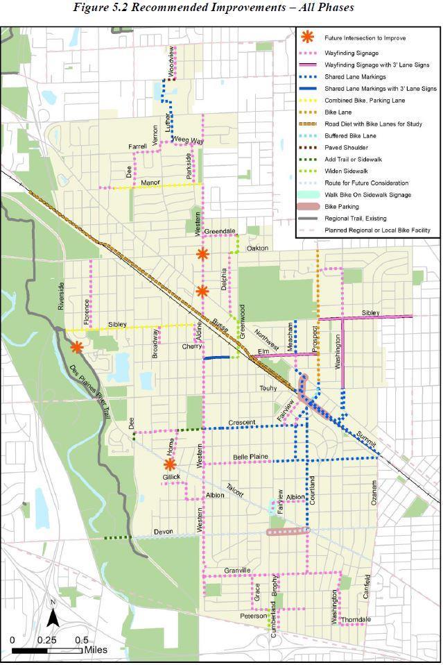
20 5 Bikeway Network Recommendations ntroduction The Park Ridge Bicycle Plan proposes an expanded network of bicycle routes to facilitate travel to all sections of the City and beyond. The recommended projects in this section will also help fill gaps, tackle barriers and improve conditions to complete the network. See Chapter 3 for more information on how routes and projects were selected, and Chapter 2 for suggested Bike Network Wayfinding Signage standards to be used for each designated segment of the network. A major caveat for the vast majority of these recommendations is that both the primary and secondary/other option recommendations assume the existing pavement width. Future reconstruction or expansion projects are opportunities to consider better bike accommodations, especially in those places where the bikeway network s comfort level target could not previously be met. The recommendations are divided into three phases of implementation consideration. Phase 1 projects are ready for implementation right away, as funding and time allow. Phase 2 recommendations need further discussion and consideration before being ready to implement. Phase 3 list potential bicycle accommodation options that could only be implemented if a suitable opportunity were to arise. Understanding the Maps The plan s maps provide a snapshot of needs and recommendations. Figure 5.1) Existing Conditions 2005 Plan (Designated) and All 2017 Studied Routes: Shows existing on-road bicyclist comfort level for all routes studied in this 2017 plan for potential inclusion in the network. Routes implemented from the 2005 Plan are also indicated. The Des Plaines River Trail is also shown. Figure 5.2) Recommended Bike mprovements - All Phases: Recommended on- and offroad bikeways, including existing facilities, areas for bike parking retrofits, and connections planned by neighboring towns. Figure 5.3) Recommended Bike mprovements Phase 1: A subset of the map above, with only those projects ready for implementation now. Other towns routes not shown. Figure 5.4) Built-out Conditions Proposed Bike Network, On-Road Comfort Level and Off-Road Facilities: Portrays how the off-road trail system and on-road bicycle level of service will change, if the recommended projects are implemented. Only those on-road segments in the network are shown. Figure 5.5) Public bicycle map: The proposed on-road and off-road bicycle network, as rated by the Bike Task Force. The on-road comfort level ratings, which closely align with the Bicycle Level of Service scores in Figure 5.4, use the excellent (green), good (yellow) and fair (orange) levels seen in Active Transportation Alliance s Chicagoland Bicycle Map. The map further describes the comfort level at each gradation. 18
21 Consider Prospect from Oakton to Summit as an example of using the maps, the spreadsheet from Appendix 2, and the notes following Tables 5.1, 5.2, and 5.3. The existing conditions map shows Prospect s Bicycle Level of Service comfort level of high-c for most of its length, except for a high-d from Grant to Touhy/Northwest. The recommended bikeway maps call for bike lanes on a section from Oakton to Cedar where enough pavement width is possible for such striping, if parking is removed. The Appendix 2 spreadsheet, as well as Note K, provides implementation details as well as backup options, if bike lanes are not implemented there. Shared lane markings are recommended from Cedar to Touhy/Northwest. Between Touhy/Northwest and Summit, the map indicates a southbound buffered bike lane and northbound shared lane markings. Again, implementation details for each are in the spreadsheet and note. The built-out conditions map and spreadsheet show that bike lane striping on those two segments of Prospect would improve their comfort level from a high-c Bicycle Level of Service to a high-b. Shared lane markings would not significantly change comfort level, but would provide network connectivity. The public map rates Prospect as excellent where bike lane striping would be added, good from Elm to Grant, and fair in the Uptown area. 19

22 Figure 5.1 Existing Conditions 20
23

24 5.3 Recommended mprovements Phase 22

25

26 Figure 5.5 Public Bicycle Map 24
27 Understanding the Project List Extensive data collection on existing bicycling conditions informed the development of this plan. Most of this information, such as roadway geometry, traffic conditions, Bicycle Level of Service, sidewalk coverage, recommendation details and implementation notes, is housed in a spreadsheet that helps create the maps. See Appendix 2 for the entire dataset by road segment. The table below summarizes recommended projects by road name, sorted alphabetically. Table 5.1 lists Phase 1 project that are ready for implementation; Table 5.2 lists Phase 2 possible projects needing further discussion. Table 5.3 lists Phase 3 future options. Following each table is footnote text detailing many recommendations. Table 5.1. Recommended Projects - Phase 1 Street From - To On Road Recommendation Off Road Note Recommendati on Albion Seminary to Western (0.13 miles) Bike Route wayfinding signage A Albion Cumberland to Courtland (0.24 miles) Bike Route wayfinding signage Aldine Sibley to Cherry (0.12 miles) Bike Route wayfinding signage Ballard Woodview to Lutheran Gen. parking Pave shoulders B (0.07 miles) Belle Plaine Western to Courtland (0.74 miles) Bike Route wayfinding signage C Belle Plaine Courtland to Canfield (0.49 miles) Shared Lane Markings C Broadway Sibley to Cherry (0.12 miles) Bike Route wayfinding signage Brophy Granville to Glenlake (0.13 miles) Bike Route wayfinding signage Brophy Petersen to Higgins (.14 miles) Bike Route wayfinding signage Cherry Aldine to Western (0.06 miles) Bike Route wayfinding signage Courtland Prospect to Talcott/Devon (0.88 miles) Shared Lane Markings D Courtland Talcott/Devon to Petersen (0.56 miles) Bike Route wayfinding signage Crescent Home to E of Home (0.06 miles) Bike Route wayfinding signage A Crescent trail E of Home to Western (0.13 miles) Add wayfinding signage A Crescent Western to Courtland (0.74 miles) Shared Lane Markings E Cumberland Peterson to Higgins (0.14 miles) ntersection improvements Cumberland Albion to Talcott (.07 miles) Walk Bike Dee Farrell to Manor (0.25 miles) Bike Route wayfinding signage Delphia Oakton to Northwest (0.49 miles) Bike Route wayfinding signage G Elm Western to Delphia (0.18 miles) Shared Lane Markings and 3-ft law sign Elm Delphia to Greenwood (0.06 miles) Widen sidewalk to sidepath width Elm Busse to Prospect (0.49 miles) Bike Route wayfinding signage and 3-ft law sign Fairview Main to Garden (0.11 miles) Shared Lane Markings Fairview Garden to Crescent (0.11 miles) Bike Route wayfinding signage Farrell Dee to Vernon (0.18 miles) Bike Route wayfinding signage Florence Oakton to Sibley (0.49 miles) Bike Route wayfinding signage F H G H 25
28 Street From - To On Road Recommendation Off Road Recommendation Gillick Hamlin to Seminary (0.12 miles) Bike Route wayfinding signage A Grace Granville to Peterson (0.24 miles) Bike Route wayfinding signage Granville Western to Washington (0.99 miles) Bike Route wayfinding signage Greendale Western to Greenwood (0.24 miles) Bike Route wayfinding signage G Greendale Western to Greenwood (0.01 miles) Trail link G Greenwood Greenwood Greendale to Oakton (0.12 miles) Northwest to Elm (0.26 miles) Widen sidewalk to sidepath width Widen sidewalk to sidepath width Home Crescent to Talcott (0.25 miles) Bike Route wayfinding signage A Luther Dempster to Weeg Way (0.18 miles) Shared Lane Markings B Lutheran Gen. parking Ballard to Dempster (0.32 miles) Shared Lane Markings B Manor Potter to Franklin School (0.1 miles) Bike Route wayfinding signage Manor Franklin School to Western (0.64 miles) Combined bike/parking lanes Meacham Sibley to Elm (0.25 miles) Shared Lane Markings J Meacham Elm to Northwest (0.11 miles) Bike Route wayfinding signage with bike box Michael John Prospect to Washington(.17 miles) Bike Route wayfinding signage Northwest Delphia to Greenwood (0.07 miles) Sidewalk improvement Northwest Meacham to Summit (0.08 miles) Shared Lane Markings J Oakton Delphia to Greenwood (0.06 miles) Parkside Weeg Way to Manor (0.29 miles) Bike Route wayfinding signage Peterson Grace to Cumberland (0.11 miles) Bike Route wayfinding signage Peterson Brophy to Courtland (.19 miles) Bike Route wayfinding signage Sidewalk improvement Prospect Oakton to Cedar (.90 miles) Bike Lanes K Prospect Grant to Northwest (.10 miles) Shared Lane Markings K Prospect (Sbd) buffered bike lane in future) Shared Lane Markings (explore Northwest to Summit (0.12 miles) K Prospect (Nbd) Northwest to Summit (0.12 miles) Shared Lane Markings K Prospect Summit to Garden (0.15 miles) Shared Lane Markings Prospect Garden to Crescent (0.06 miles) Bike Route wayfinding signage Seminary Gillick to Albion (0.12 miles) Bike Route wayfinding signage A Sibley Talcott to Aldine (0.93 miles) Combined bike/parking lanes L Sibley Summit Prospect to Oriole (0.68 miles) Northwest to Metra station (0.17 miles) Bike Route wayfinding signage and 3-ft law sign Shared Lane Markings Summit Metra station to Canfield (0.61 miles) Shared Lane Markings Thorndale Washington to Canfield (0.18 miles) Bike Route wayfinding signage Vernon Weeg Way to Farrell (0.06 miles) Bike Route wayfinding signage Washington Michael John to Sibley (0.36 miles) Bike Route wayfinding signage Washington Sibley to Touhy (0.5 miles) Bike Route wayfinding signage and 3-ft law sign Washington Touhy to Summit (0.27 miles) Shared Lane Markings M Washington Granville to Thorndale (0.38 miles) Bike Route wayfinding signage Note G G J G G H J H 26
29 Street From - To On Road Recommendation Weeg Way Vernon to Western (0.32 miles) Bike Route wayfinding signage Western Dempster to Weeg Way (0.22 miles) Bike Route wayfinding signage Western Manor to Greendale (0.37 miles) Bike Route wayfinding signage Western Cherry to Southwest Park (1.78 miles) Bike Route wayfinding signage Off Road Recommendation Woodview Chuch to Ballard (0.25 miles) Bike Route wayfinding signage B Note A Maine South access options. Two main access points for students walking and biking to the high school are the sidewalk/gate off Hamlin and the back driveway off Talcott. For each, a spur route with wayfinding signage is recommended from Western. Albion, Seminary, and Gillick (through The Farm, if and when developed) to the Hamlin gate would be the primary bike network access to the high school. The alternative option would use the trail through Centennial Park, Crescent, Home, and Talcott s north sidewalk to the crossing guard-controlled crossing of Talcott. See Note P for a discussion of the Talcott crossing. B Lutheran General and access north of Dempster. The study found no great ways to access Park Ridge north of Dempster. One possibility would require Lutheran General Hospital to allow shared lane markings (and bike network wayfinding signage) on their internal roads and parking lot. The markings would be centered 4-ft from the curbs on these internal roads and on Luther between Dempster and Weeg Way. Ballard s gravel shoulders could be paved between the Lutheran General entrance and Woodview, with sidewalks serving the less traffic-tolerant. Woodview would only need wayfinding signage, to Church, a popular bike route. C Belle Plaine. Western to Courtland is too narrow for bike lanes, and too low in parking occupancy for good use of shared lane markings. Wayfinding signage is the only feasible bikeway treatment, although traffic calming could be implemented to address a higher bike crash rate from Western to Greenwood. The easiest and lowest cost solution would be to install Must Stop for Pedestrian signs at crossings. t is also recommended that the police department conduct occasional well-publicized, small-scale targeted enforcement calling attention to the need for drivers and bicyclists to obey stop signs here and elsewhere. Parking occupancy on the wider segment from Courtland to Canfield has been deemed high enough to justify shared lane markings centered 11-ft from the curbs. D Courtland, Prospect to Talcott/Devon. There s not enough width for bike lanes, and parking occupancy is too high for combined bike/parking lanes. Parking occupancy has been deemed high enough to justify shared lane markings centered 11-ft from the curbs. Near the traffic signal at Devon/Talcott from either the north or south, parking is prohibited, resulting in two de facto travel lanes on the approaches. Recommended are shared lane markings centered in the right of those two lanes, along with the MUTCD s R10-22 Bicycle Signal Actuation sign and pavement marking just before the stop lines. 27
30 E Crescent, Western to Courtland. Recommended from Western to Lincoln are shared lane markings. The SLMs would be centered 4-ft from the eastbound curb and 6 or 7-ft from the westbound curb due to angled parking. From Lincoln to Greenwood, add SLMs centered 4-ft from the westbound curb. For eastbound, shared lane markings are not suitable due to low but nonzero parking occupancy so use only. From Greenwood to Courtland, westbound parking occupancy is high enough to justify shared lane markings centered 11-ft from the curb. The markings can be centered 4-ft from the eastbound curb since there is no parking in that direction. F Cumberland s west sidewalk, Peterson to Higgins. A lack of other good options leads to sidewalk use by those biking to the CTA Blue Line station. deally, the sidewalk would be widened to 10 feet, but that might be difficult. Signs asking cyclists to walk their bikes should be added if it is desired to officially designate the sidewalk as part of the bike network. Whether the sidewalk is widened or not, add high-visibility, continental crosswalks across Higgins and the entrances to Mariano s. Also, a demand-actuated Lead Pedestrian nterval should be considered for the stoplight at Higgins, to reduce conflicts with southbound right-turning traffic. G Greenwood-based route to northwest Park Ridge. There are no easy ways to access the section of town west of Greenwood and north of the railroad tracks. While far from ideal, the following is recommended between west Elm and north Western. Elm s bikeway should transition between on-road west of Delphia and the north sidewalk east of Delphia. deally, widen the north sidewalk to 8 or 10-ft to Greenwood. At the east face of the Delphia intersection, widen the curb ramp and add W11-15 with W16-7p signs in Fluorescent Yellow-Green (FYG) color. f off-road is not possible, then move the widened curb ramp and signs to the west face of the Greenwood intersection, although southbound right-turning traffic onto Elm makes this a less desirable location for a transition. Use Greenwood s west sidewalk from Elm to Northwest Highway. deally, and likely as a lower priority than other plan improvements, it would be widened to 8 or 10-ft. Regardless, the sidewalk (or sidepath) would need curb cuts on the soon-to-be-developed parcel between Northwest and Busse, and the northwest corner island at Busse would need ADA improvements. Greenwood is not a good candidate for an on-road or off-road bikeway between Northwest and Oakton, due to lack of space on the east side and unfavorable conditions residential front yards, large setback, many driveways on the west. The recommended (but non-ideal) fallback option is to use Delphia with wayfinding signage alone, connecting to Greenwood using Northwest s north sidewalk and Oakton s south sidewalk. deally, for the two sidewalk pieces to be official bikeways, they would have to be widened to 8 or 10-ft with a 5-ft buffer. For this to happen, landscaping, utility poles, and parked car issues would have to be solved. f not, signs asking cyclists to walk their bikes may be used. Oakton intersection s west face and crosswalk should be moved closer to Greenwood. North of Oakton, Greenwood s west sidewalk could be widened by the fire station. A short (less than 10-ft long) sidewalk link to Greendale would need to be created, and then wayfinding signage could bring Greendale (on-road) to Western. 28

31 H State Law 3 Feet Min To Pass Bicycles signs. For four important road segments of the proposed bike network, the on-road Bicycle Level of Service comfort level rates a high-tomid C below the plan s target threshold level with bike lanes and other good options not feasible. New, DOT-approved 3-ft law signs are recommended to supplement network wayfinding signage, and, in one case, shared lane markings; on west Elm (westbound, just before or after Delphia), east Elm (eastbound, past Northwest), Sibley (eastbound, past Prospect), and Washington (northbound past Touhy). J Meacham north option to downtown. n addition to Prospect (below), another route option between downtown and points north is a bit further west. From Prospect, shared lane markings are recommended on Sibley, centered 11-ft from the westbound curb with parking and 4-ft from the eastbound curb having no parking. North of Elm, Meacham s parking occupancy is high enough for shared lane markings centered 11-ft out which could help with traffic calming efforts evidenced by speed humps. Parking is less but non-zero south of Elm, so 11-ft shared lane markings are not recommended. However, a single marking should be added centered in the southbound Meacham lane roughly 50-ft before the Northwest intersection along with wayfinding signage at or just before the intersection to turn left onto Northwest. (Continuing south on Meacham for a potential crossing of Touhy at or near Busse does not seem desirable.) To help ensure southeast-bound cyclists can get from Meacham to Summit on Northwest before southeast-bound cars arrive after the light at Meacham turns green, the Northwest intersection might be a location for a Meacham southbound green bike box with a 25 or 50-ft ingress lane on the approach. Cyclists would transition to the left side of the southbound Meacham lane. Bike boxes have FHWA interim approval. Figure 5.6 Bike box Use shared lane markings centered 11-ft out for the 400-ft segment on Northwest between Meacham and Summit. Rely on current signalization at both streets so that cyclists would not have to contend with much other Northwest traffic. Dashed or green background may be added to the shared lane markings for conspicuity. W11-1 bicycle warning signage in FYG color should be added to each direction of Northwest, before this segment. Summit from Northwest to the Park Ridge Metra Station could use shared lane markings centered 4-ft from the curbs, except where there are bus and parking pullout areas. K Prospect option to downtown, and north to Oakton. Prospect north of Oakton joins Niles bike network (which has good wayfinding signage) and a good northbound connection to the North Branch Trail. Between Oakton and Cedar, there is very little parking occupancy. Removing parking by ordinance would allow striping of 5-ft bike lanes and 10.1-ft travel 29
32 lanes, with passive traffic calming benefits to residents. Bike lanes are the recommended option, as traffic is fairly high. f parking removal is rejected, the City might research case studies from other communities where bike lanes were installed but on-street parking was allowed to continue. While this is not a federally approved bikeway, communities in the Chicago region have implemented it with some success where removing parking entirely is not palatable or preferred but the rate of onstreet parking utilization is very low. As an additional option, wayfinding signage supplemented with one State Law 3 Feet Min to Pass Bicycles signs per direction could be installed. Also, additional traffic calming measures could be implemented here. The easiest and lowest cost solution would be to install Must Stop For Pedestrian Signs at crossings. Raised crosswalks may also be a more extensive option. From Cedar to Summit, through the 6 Corners intersection with Touhy/Northwest, use shared lane markings. Northbound would be centered in the through travel lane. Southbound shared lane markings would be centered in the through travel lane or, where intuitive, in the combined through/right-turn lane. From 6 Corners to Summit, the traffic levels, comfort level, and frequent parking turnover justify dashed lines or green background paint to improve conspicuity of shared lane markings. f green paint is used, the Federal Highway Administration has experimentation requirements. After installing shared lane markings and observing their use and effectiveness, the City may in the future explore upgrading the southbound bikeway to a buffered bike lane. Buffered bike lanes offer safety benefits where cyclists are riding next to cars parked parallel to the curb. Parked cars swinging open doors into bicyclists is a common type of crash in these contexts. A possible cross-section (including the thickness of lines) would consist of a 7.5-foot-wide parking lane, a 2-foot-wide buffer, a 4-foot wide bike lane, and an approximately 10-foot-wide through travel lane. To test out the idea, the City may consider a tactical urbanism activity (temporary installation using temporary materials such as chalk) for a couple of days to observe how the realignment is received by roadway users and nearby property owners and tenants. L Sibley s combined bike/parking lanes. Where on-road parking is usually heavy, such as near the park district facility, it is recommended to replace or supplement the combined bike/parking lane stripes with shared lane markings centered 11-ft from the curbs. M Washington from Summit to Touhy. This provides yet another option in the area near downtown. Between Summit and Northwest, shared lane markings are recommended, centered 11-ft from southwest-bound curbs due to parking, and 4-ft from northeast-bound curbs. The 225-ft segment on Northwest would need shared lane markings 4-ft out, unless bike lanes were added to prevent two lanes from becoming four de facto lanes. Between Northwest and Touhy, shared lane markings are recommended, centered 11-ft from northbound curbs due to parking, and 4-ft from southbound curbs. Options are presented in the Appendix 2 spreadsheet, for the case of northbound parking being removed. 30
33 Table 5.2. Possible Projects - Phase 2 Street From - To On Road Recommendation Off Road Recommendation Note Busse W-end to Touhy (2.4 miles) Traffic study (for 4-3 lane road diet with bike lanes) Crescent Dee to Home (0.31 miles) Bike Route wayfinding signage O Dee Crescent to Talcott (0.05 miles) Fill sidewalk gap O Northwest Oakton Sibley Talcott N. Washington to S. Washington (0.04 miles) Prospect to Oriole (to Michael John if constrained) Across Talcott to Des Plaines River Trail Maine South back driveway Shared Lane Markings Multiuse sidepath mprove crossing of Talcott mprove crossing of Talcott Touhy Busse to Summit (0.06 miles) Shared Lane Markings N N M Q P P N Busse. This DOT road is a high priority route both in this plan and Northwest Municipal Conference s bike plan due to current usage, crash history, network importance, lack of good alternatives, and a generally low comfort level now. Shared lane markings (centered 4-ft or 11- ft from the curbs, depending on whether parking is permitted) could be added, however, most of Busse would remain far below the plan s target comfort level. A traffic and intersection study is recommended for a road diet lane reconfiguration creating space for much-needed bike lanes. This should be done early enough to impact DOT s planned resurfacing project for Busse. Four travel lanes could be reduced to two travel lanes, a continuous left turn lane (CLTL), and bike lanes with recommended dimensions for each segment in the Appendix 2 spreadsheet. Traffic levels are well below common thresholds for removing travel lanes with a road diet. Motorist left turns to streets, driveways, and entrances not currently having left-turn lanes should become safer. Bike lanes would also have a traffic calming effect. No parking would be removed, and northwest-bound parking could be added between Dee and Potter. Between Dee and Morris, travel lanes and/or the CLTL would have to be barely below the 11-ft minimum standard, but the result would still be wider than current lanes. To continue the bike lanes at major intersections having right-turn lanes, consult the NACTO Urban Bikeway Guide. f Busse bike lanes are implemented, shared lane markings centered 4 from the curbs could be used with wayfinding signage for the short 300-ft segment of Touhy between Busse and Summit as Summit connects to the Metra station and Prospect. Touhy s current signalization timing at Busse and Summit should make that possible without contending with other Touhy traffic. Still, W11-1 and W16-9p bicycle warning signage in FYG color should be added to Touhy before this segment. To make the transition more visible to drivers and easier for cyclists, place intersection markings through the intersection, per the NACTO guide. Also, highlight marked shared lanes either with dashed lines or green paint an experimental treatment, per FHWA, that has been used in Chicago, Evanston, and other cities around the nation. 31
34 O Crescent and Dee alternative route to Maine South. f right-of-way is acquired to construct a sidewalk on the east side of Dee from Crescent to Talcott, it would allow another albeit, longer network spur to Maine South High School, having the advantage of a signalized crossing of Talcott. P Unsignalized Talcott crossings. Two unsignalized crossings of Talcott are important to the bicycle network: Sibley to the Des Plaines River Trail, and the back driveway entrance to Maine South High School. Access to the Des Plaines River Trail is difficult in Park Ridge. Despite its unsignalized crossing of two-lane (plus left turn lane) Talcott, the Sibley crossing and short link to the trail is the most used in the city. The crossing is recommended for improvement in the Northwest Municipal Conference s Des Plaines River Trail crossing study. n addition to Talcott s east sidewalk s missing curb cuts and crossing of Sibley, possible improvements to the Talcott crossing there could include: Continental crosswalks across the north intersection face, with advance W11-15 (with W11-15p) trail crossing warning signage in FYG color on Talcott. Alternatively, as a lower priority due to the geometry and Talcott s moderate traffic count, the intersection s south face could be used, adding a continental crosswalk and raised median island, with a short west-side trail link to the existing trail. n either case, Rectangular Rapid Flashing Beacons (when available) could be used here on both sides and, if added, on the raised median. f RRFBs are added, use W11-15 and W16-7p signs in FYG color, instead. f Talcott s sight lines at Sibley are unacceptable for a designated crossing there, similar crossing improvements could be implemented at Cherry, with bike network wayfinding signage directing users on Cherry, Halien, and Scottlynne to Sibley. The four-lane Talcott crossing at the Maine South back driveway currently has a crossing guard during school arrival and departure times. Being a multi-lane road in particular, multiplethreat crashes in which the outer lane motorist stops but the inner lane motorist doesn t are a concern. DOT has rejected a traffic signal as not meeting MUTCD warrants. To date, the City has researched and rejected the following: Rectangular Rapid Flashing Beacons under a school or pedestrian crossing warning sign. Pedestrian Hybrid Beacons would address pedestrians and bikes, and the peak hour pedestrian crossing warrant of 20 is likely to be met there. However, a PHB would not address cars turning out of that entrance. A road diet from four lanes to three with a center turn lane discussed in a later note on Talcott in this chapter. This issue should be revisited in the future. Q Oakton. The south side of Oakton Street between Prospect (west) and Oriole (east) completely lacks a sidewalk, as the residential properties that border it are fenced off to the south and front Kathleen Drive, not Oakton. This segment is near Emerson Middle School and along Pace route 226, and within walking distance to the Pace PULSE arterial rapid transit bus route along Milwaukee Avenue in Niles. Having no bicycle or pedestrian infrastructure in this 32
35 segment is especially problematic because there is no signalized crossing to the north side, where sidewalks are present. Therefore, students who attend Emerson but live in northeast Park Ridge do not have an efficient walking or biking route to and from the school, and there is no Pace bus stop in this segment because there is no sidewalk or sidepath. However, the lack of driveways presents an opportunity for an off-street facility, which would accommodate both bicyclists and pedestrians. The conflict points exist only at the intersections of Washington and Michael John. The multiuse sidepath, at a minimum of 8 feet wide, could be signed as a bike route while also allowing users such as pedestrians and joggers. Like the Prospect bike lane, the sidepath would provide a connection to Niles, particularly the Oak Mill shopping area. Though off-street facilities can be costly, the City may monitor for available grants or planned DOT roadwork to study and construct the project if outside funding becomes available. Table 5.3. Possible Projects - Phase 3 Street From - To On Road Recommendation Off Road Recommendation Note Devon W-end to Dee (0.24 miles) Add sidepath or sidewalk; intersection improvements Devon Dee to Canfield (1.75 miles) Future options? S Talcott Dee to Canfield (1.93 miles) Future options? R S Western Greendale to Busse (0.57 miles) Bike Route mprove crossings of Oakton, Northwest T R Talcott. Future options could improve bicycling along Talcott, with possibilities described below. Between Dee and Western, Talcott has four lanes and a traffic count of well within the consideration of a 4-to-3 lane road diet with a center left turn lane. A traffic and intersection study would inform the feasibility of this. f a road diet were implemented, there should be enough width remaining for 5-ft bike lanes on each side. Also, it would allow for an improved crossing of Talcott at or near Maine South s back driveway entrance and elsewhere. All of Talcott southeast of Western, with the exception of Cumberland to Fairview, is marked for two wide lanes but driven like four lanes if cars are not parked. Non-rush hour parking is allowed, with occasional occupancy in the residential areas and higher occupancy around businesses. Parking stalls are marked from Cumberland to Fairview. f it ever becomes desirable to better delineate parking and traffic, and if a traffic and intersection study verify that two travel lanes are sufficient, then an option would be to add striping to separate 13-ft lanes and 8-ft parking southeast of Western to the city limit. n the residential areas where parking is minimal, bicyclists would likely choose to ride in the parking lanes like urban shoulders except to merge left to go around the occasional parked car. While doing so is not ideal because of the traffic counts, cyclists would likely feel more comfortable overall than without the stripes. f the route were then to be designated as a 33
36 bikeway, Bike Route wayfinding signage would be appropriate, perhaps with shared lane markings (centered 11 from the curbs) only where parking occupancy is usually above 30%. f ever parking were to be disallowed in the residential areas between Western to Canfield, there would be room for buffered bike lanes (5-ft with 2-ft traffic-side buffers) in a two-lane crosssection. However, unless lane widths were just under 11-ft, a three-lane cross-section with center left-turn lane would not have enough width for 5-ft bike lanes. Urban shoulders of 4-ft or 4.5-ft, without bike lane signs or pavement stencils, would add comfort for cyclists if they were approved. S Devon. At Devon s west end, a 70-ft north sidewalk or (to match Des Plaines bike plan) sidepath is recommended between the Des Plaines River Trail and Dee, adding curb cuts and crosswalks to the W and N faces of the Dee intersection. Extending west along Devon from the trail to Des Plaines would connect with a proposed sidepath there, but forest preserve right-ofway would be needed. Between Dee and Aldine, a south sidepath may be possible depending on forest preserve property, but access to homes and streets on the north would require crossings mid-block or at unsignalized intersections. Widening the north sidewalk across many driveways and through residents front yards is not recommended. Parts of Devon are similar to Talcott, but Devon s median and higher traffic counts east of Cumberland and especially Courtland further reduce possibilities. With somewhat less traffic west of Cumberland, there may be the opportunity (pending a traffic study) for the City and DOT to opt to officially restrict traffic to two lanes, while delineating space for lightlyoccupied parking and/or bikes. n that case, bike accommodation options are like Talcott s. Such improvements along Talcott and Devon would improve bike access to the South Park commercial area, which is not well-served by the Phase 1 routes. T Western at Oakton and Northwest. Western north from Busse could be an excellent bikeway network route to the underserved northwest part of the city, but unsignalized four-lane crossings at Oakton and Northwest are major obstacles. Oakton, in particular, has a very high (26400 ADT) traffic volume, almost necessitating a traffic-controlled crossing. Chapter 2 s mproving Signal Crossings provides potential treatments to study for Western s crossings of both Oakton and Northwest. 34
37 Miscellaneous nvestigation of Traffic Signals for Bicycle Actuation. An advantage of using collector streets in a bikeway network is that these roads usually have traffic signals to aid in crossing busier, arterial roads. There is a strong possibility that these stoplights are demand-actuated for those traveling on the collectors. Bicycles must be able to actuate the traffic signals detectors otherwise the routes become less useful to the network. t is recommended that the demand-actuated signals slated for the routes of the bikeway network be field-tested for bicycle actuation. Chapter 2 lists some possible remedies. Additional routes and fallback options. Many of the suggested routes to study by the public did not result in a recommendation, due to lack of feasibility, redundancy with a nearby network segment, and/or other factors. However, for a subset of these routes, the spreadsheet in Appendix 2 provides suggestions on what bikeway type(s) would be appropriate if those segments were added to the network. n addition, the spreadsheet sometimes lists fallback options for routes in which it is decided not to implement the plan s primary recommendation. n other cases, lower priority enhancements to the primary recommendation are suggested, when desired. 35


38 6 Other Recommendations ntroduction Engineering improvements to the physical environment for cycling should be accompanied by work in the other E s : Education, Encouragement and Enforcement. The recommendations below will raise awareness of new facilities and motivate more people to safely and comfortably bike in Park Ridge. Bicycle Parking is treated as a separate category, given the breadth of the topic and its relationship to both engineering and encouragement. Bicycle Parking Secure bicycle parking is a necessary part of a bikeway network, allowing people to use their bikes for transportation and reducing parking in undesirable places. Successful bicycle parking requires a solid bike rack in a prime location. t is recommended that the City address bike parking by adopting a development ordinance requirement and by retrofitting racks at strategic locations in town. General bicycle parking considerations are covered below. For more details, consult Bicycle Parking Guidelines, 2nd Edition: A Set of Recommendations from the Association of Pedestrian and Bicycle Professionals, at Style: A good bicycle rack provides support for the bike frame and allows both the frame and wheels to be secured with one lock. The most common styles include the inverted U (two bikes, around $ ) and post and loop. The preferred option for multiple spaces is a series of inverted U racks, situated parallel to one another. These can be installed as individual racks or as a series of racks connected at the base, which is less expensive and easier to install and move, if needed. See Figure 6.1. Old-fashioned school racks, which secure only one wheel, are a poor choice for today s bicycles (Figure 6.2). Securing both the wheel and frame is difficult, and bicycles are not well supported, sometimes resulting in bent rims. Figure 6.1. nverted U, single (top) and in a series (bottom). Figure 6.2. Schoolyard rack, not recommended. Locations: The best locations for bike parking are near main building entrances, conveniently located, highly visible, lit at night, and when possible protected from the weather. When placing a bicycle rack in the public right-of-way or in a parking lot, it should be removed from 36
39 the natural flow of pedestrians, avoiding the curb and area adjacent to crosswalks. Racks should be installed a minimum of 6 feet from other street furniture and placed at least 15 feet away from other features, such as fire hydrants or bus stop shelters. The installation recommendations below are from the Kane County Bicycle & Pedestrian Plan: Anchor racks into a hard surface nstall racks a minimum of 24-in from a parallel wall nstall 30-in from a perpendicular wall (as measured to the closest inverted U.) Allow at least 24-in beside each parked bicycle for user access, although adjacent bicycles may share this access. Provide a 6-ft aisle from the front or rear of a bicycle parked for access to the facility. Ordinances: deally, all multi-family and non-residential buildings should provide bike parking. A simple ordinance may call for one bike parking space for every 10 or 20 required car spaces, with a minimum of two spaces. The City of Naperville has a very good ordinance (Section 6-9-7) specifying bike rack standards and a detailed list of required spaces per land use. Most uses call for 5% of car spaces, with higher amounts for multi-family dwellings, schools, recreation facilities, etc. For suggestions on bike parking requirements according to land use type, consult the APBP bicycle parking guide referenced above. The bicycle parking section in the City of Champaign s zoning ordinance (Section to ) not only specifies amount of bike parking per land use, but also bike rack type and general requirements for on-site location. Other Retrofits: Retrofit bike parking is recommended in places of latent demand, including public buildings, recreation facilities, and commercial centers. (Note that retrofitting racks on commercial properties and other private property will require cooperation from the property managers.) Park Ridge s Bike Task Force identified bike parking needs with an extensive survey at strategic locations. A first phase of improvements was implemented in August of 2017 at the Uptown Metra Station. Additional bike parking is targeted in 2018 for the rest of the Uptown and South Park areas. Education There is a big educational gap for both bicyclists and motorists on how to legally and properly share the road. The result: avoidable crashes, too many people afraid to bike, and lots of anger and resentment. Education of both road user types is crucial to improving real and perceived bicycling safety in Park Ridge. nvesting some resources on public outreach and education would greatly leverage the City s infrastructure investment. Many of the safety resources listed below are free, except for the time to get and use them. Much of this time could come from the Bike Task Force members and/or other volunteers. 37

40 Bicyclists: Many people are afraid to bike, or bike only on off-road trails, because of their concern about safety. mproving education can lessen these concerns and instill the skills and confidence to bike to more places around town more safely. The following safety materials could be distributed through schools and PTAs, at public places such as City Hall and the library, and on the City s and park district s websites: Bicycle Rules of the Road, a free guide from the llinois Secretary of State: Bike Safety, a free brochure from the llinois State Police: Ride llinois single-page summaries for children and their parents. rideillinois.org/safety/kids-and-biking-resources llinois Bicycle Law cards, free from Ride llinois. Relevant state laws, folds to business-card size. rideillinois.org/wp-content/uploads/2015/10/bikelawcard2015.pdf n addition, llinois has a network of bicycle safety instructors, nationally-certified by the League of American Bicyclists, to teach a menu of classes for children and adults. These could include learn to ride classes, traffic safety, and bike mechanics. These classes or training of new instructors could be conducted in Park Ridge. nstructors are listed at An online interactive resource on relevant laws and safety techniques is Ride llinois Concise quiz-based lessons are freely available for Adult Bicyclists, Child Bicyclists, and Motorists. Besides individual use, the application has functionality for easy use by schools, driver education programs, scouts, YMCAs, and more. Ride llinois has brief text promoting the quiz, available for municipal newsletters and websites. Figure 6.3. Motorist Quiz at Motorists: Drivers not trained on car-bike interactions are much more likely to make mistakes that are dangerous to people on bikes. The following safety resources are available from Ride llinois, for driver education programs and existing motorists: The Motorist and Driver Education quizzes in the resource mentioned above. Share the Road: Same Road, Same Rights, Same Rules, a 7-minute video available at and as a DVD The plan recommends that local high schools and private driver education programs be encouraged to use and/or the video and its accompanying lesson. Both resources could be added to the City website. During warmer months, the video could be shown on the local cable channel and the articles could be published for residents. 38
41 Bikes on Transit: Many cyclists are unaware or unsure of how to take their bikes on Pace, CTA, or Metra. Flyers or online resources should be distributed to the community at events and in publications. Visit for Metra s guidelines, for CTA s guidelines, and for Pace s guidelines. Community-wide education: Park Ridge can distribute information about safety and new bicycle facilities to the community through the City s website, cable access station, social media accounts, or local papers to broadcast videos and publish articles on how to use new bike facilities and bike safety. Enforcement A vital component of a safe bicycling environment is enforcement with education to reduce common car-bike collision types. According to llinois law, bicyclists have both the rights and responsibilities of other vehicle users. Many cyclists do not know about the law as it applies to bikes and how following the law leads to safe cycling. Other cyclists ignore the law while riding in traffic, not only creating dangerous situations but also causing motorist resentment toward other cyclists trying to share the road safely. Police are encouraged to stop cyclists if the situation dictates, to educate, issue warning citations, or issue tickets. Changing their behavior could save their lives. The aforementioned llinois bike law cards are available from Ride llinois. Also, Ride llinois has piloted a bicycle ticket diversion program in Urbana, Champaign, and Highland Park. To reduce a ticket to a warning, offenders take the Adult Bicyclist quiz at ing their completion certificate to the police department. This has been received well and is suitable for Park Ridge, too. n a car-bike crash, the motor vehicle does the most damage. Some aggressive motorists intentionally harass cyclists, while others simply don t know how to avoid common crash types. As with cyclists, police are encouraged to stop motorists if needed, to educate, issue warnings, or issue tickets. An annually-conducted, brief but well-publicized targeted enforcement campaign (aka sting ) can raise community awareness about particular problem issues such as the high crash segment of Belle Plaine. Warning tickets would be issued, along with instructions to complete the appropriate lesson. Officers are encouraged to learn or refresh their own knowledge on the common crash types through completion of the Motorist and Adult Bicyclist quiz lessons. Finally, police might consider replicating an earlier Hoffman Estates bike safety kit program. There, the police regularly noticed mostly low-income workers, relying on their bicycles for year-round transportation to their jobs. These residents, riding at dark on busy roads, were 39
42 often at risk due to a lack of bike lights and reflective clothing. Officers distributed a kit of these items when they witnessed a cyclist in that situation. This low-cost program was a muchappreciated success that could be duplicated here. These and other enforcement ideas are detailed in the llinois Association of Chiefs of Police s magazine: rideillinois.org/wp-content/uploads/2016/01/policechiefsarticle_spring2014.pdf Encouragement Suggestions for encouraging visitors or residents to explore Park Ridge by bicycle include: Creating and distributing a bicycle map showing the preferred road routes, nearby trails, and bicycle safety information at public buildings and during events. Proclaim the City s observance of National Bike Month, Week, or Day. As part of the event, challenge residents to do the Have the Mayor lead by example, holding his own certificates of completion from the Adult Bicyclist and Motorist quizzes in a press release photo publicizing the event. On Bike to Work Day, encourage bicycling to work, errands, or other destinations. Offer token incentives, such as refreshments at City Hall or coupons for ice cream. The City of Park Ridge and other local employers could be encouraged to participate in Active Transportation Alliance s Bike Commuter Challenge, a two-week competition where employers around Chicagoland encourage employees to log as many miles and take as many bike trips as possible to- and from-work bikecommuterchallenge.org. Work with the school districts to observe National Bike to School Day, in early May. Promote Park Ridge as being bicycle-friendly in the City s advertising. Work with local companies to sponsor a bike light or helmet give-away in conjunction with Bike Week or another special event. The giveaway could include helmet fittings and other safety demonstrations. 40
43 7 Plan mplementation ntroduction A key recommendation of this plan is to develop a way to ensure its implementation. Continued progress will require a commitment of time and financial resources over many years. Little by little, project by project, the City of Park Ridge will become even more bike-friendly. Bicycle and Pedestrian Advisory Commission and Coordinator Perhaps the most important implementation tool is time. The plan recommends dedicating a fraction of a staff member s time as the City s Bicycle and Pedestrian Coordinator. This individual would work on plan implementation and other active transportation issues. Also, the coordinator would regularly collaborate with other City staff and relevant agencies to ensure their work conforms to the goals of the plan. Routine review of development plans and road project designs is a prime example. n addition, the plan recommends the continuation of the Bike Task Force as an ongoing Park Ridge Bicycle and Pedestrian Advisory Commission (BPAC), reporting to City Council or to the City Administrator/Mayor s Office. Volunteer involvement by a few energetic, knowledgeable, and dedicated residents can greatly leverage the staff time investment of the Bicycle/Pedestrian Coordinator, who would serve as the lead staff liaison to the BPAC. BPAC membership should be limited to 4-7 residents, mostly bicyclists ranging in experience. f these individuals lack interest in pedestrian-only issues, too, then at least 1-2 members should specifically represent these topics. deally, the residents who volunteer for BPAC should have some relevant, specialized expertise and/or be willing to work on tasks outside of the meetings. Other BPAC members may come from other City departments (Community Preservation and Development, Public Works, Police) or relevant agencies (such as the Park Ridge Park District and Park Ridge-Niles School District). However, it may be best for these departments and agencies to name representatives as ex-officio members, attending only when relevant topics are discussed. Meetings should be held every one to four months, depending on level of activity. The BPAC should routinely be given the opportunity to provide input into these City processes: Capital mprovement Program How can designs of the CP s road projects and other capital projects implement bicycle plan recommendations or otherwise impact bicycling (and walking) positively? Also, the BPAC should propose stand-alone bike and/or pedestrian projects as priorities for the next CP, each year. Site design and other development review Provide bicycle and pedestrian perspective to the City s review of new development or re-development projects. 41
44 Maintenance The BPAC should periodically review conditions on the City s bikeway system and make prioritized maintenance recommendations. n addition, the BPAC members should be empowered to work on several one-time and ongoing recommendations from this plan and other efforts. Examples include: Continue the Bike Task Force s work on prioritizing specific locations where bicycle parking is needed. Prioritize Park Ridge bikeways needing wayfinding signage, and specifying destination content for each sign based on general guidelines from this plan. Field test demand-actuated traffic signals along the planned bikeway network, to determine and prioritize where bicycle-actuation improvements are needed. Bring or apply a variety of available education, enforcement, and outreach resources such as those detailed earlier in the plan to Park Ridge. Act as volunteer bicycle ambassadors at community events. Lead bike-related events, such as Bike to Work Day/Week/Month or Bike to School Day. Head the effort to win national Bicycle Friendly Community designation, including filling out the application, and strategizing which areas need improvement. t is strongly recommended that each commission member should have ownership of at least one topic or effort. This will keep members energized and ensure the commission is a net positive in City time investment. Multi-Year Work Plan This plan recommends a variety of strategies, from adopting policies to coordinating with other agencies, to quickly implement high priority, ready to go projects. One of the first steps of plan implementation should be to go through the listed recommendations and draft a five year work plan. Some projects may be components of larger road projects in Park Ridge s Capital mprovement Program. Others may be stand-alone retrofit projects. Projects that do not get completed on a given year move into a future year s work plan. Dividing plan implementation across a span of years makes it more manageable, especially in terms of funding. mplementation Funding Recommendations in this plan range from low-cost improvements to major capital investments. Project costs depend on myriad factors. t is usually most cost effective to address bicycling improvements as part of larger projects, instead of retrofitting. Estimates for various on-road bikeway types are below; these estimates can be used with the segment lengths of Tables 5.1, 5.2, and 5.3. The higher cost of off-road improvements, such as widening sidewalks and adding new sidepaths, varies dramatically according to factors determined in engineering so estimates are not provided here. 42
45 Signed Bike Routes: Only and their posts are needed, estimated to cost $54 with a post and $24 without, for 18 X 24 signs. The number of signs and posts per mile depend on the characteristics of each segment, but an average of $500 per mile (total for both sides) is used. Shared Lane Markings: The total per-mile estimate of $16,500 per mile includes $400 pavement markings every 250 feet, plus wayfinding signage. Bike Lanes: The cost of installing bike lanes on both sides of the road is also estimated at $16,500 per mile, on no-parking roads in which only two stripes are needed. This includes 6-in wide thermoplastic stripes ($0.75/ft), $400 bike lane pavement markings every block, and. Where two extra stripes (4-in, $0.55/ft) are needed to delineate each side s adjacent parking and bike lane, the estimate is $22,200 per mile. Another 4-in stripe to implement buffered bike lanes with parking raises the estimate to $28,000 per mile, or $14,000 per side. Combined Bike/Parking Lanes: With, two 6-in stripes and no markings, combined bike/parking lanes on both sides of the road are estimated to cost $8,420 per mile. These may be funded in a number of ways. First, the City of Park Ridge may dedicate an annual budget for a bicycle implementation program. f needed, one strategy may entail a smaller first year budget for the highest priority projects, as a way to build momentum for following years. Other opportunities include road projects by the City, Cook County, or the State. Addressing intersection improvements, bikeways, and sidewalks as part of a larger road project is usually cheaper and easier than retrofitting. Even resurfacing work can be used to add on-road bikeway striping. n fact, it is likely that resurfacing projects will be a major component of plan implementation. Finally, outside government funding sources can be used for bikeway retrofit projects, for project budgets high enough to make the extra administrative effort and delay worthwhile. A number of state and federal grant programs are available and summarized in Appendix 3. Technical Resources and Training City staff should have access to up-to-date resources to help with the details of design and implementation. n addition to including the printed resources below in the City planner s and engineer s library, seek out opportunities to participate in webinars and workshops on best practices. For example, in recent years, the NACTO Urban Bikeway Design Guide training has been offered in Chicago. Not only do these events provide useful information, they are an opportunity to interact with other planners and engineers grappling with similar issues. Manuals and Guidelines: AASHTO Guide for the Development of Bicycle Facilities, 4th Edition, Available at 43

46 Bicycle Parking Guidelines, 2nd Edition: A Set of Recommendations from the Association of Pedestrian and Bicycle Professionals, 2010, available at NACTO Urban Bikeway Design Guide. Online at Manual on Uniform Traffic Control Devices. Online at mutcd.fhwa.dot.gov. Websites and Professional Organizations: The Pedestrian and Bicycle nformation Center: Offers a wealth of information on engineering, encouragement, education and enforcement, including archived webinars and quarterly newsletters: The Association of Pedestrian and Bicycle Professionals: provides continuing education, technical resources and an online forum for exchanging questions and ideas. Ride llinois: A planning and advocacy resource, with many on-line materials focused on best practices nationally as well as issues unique to llinois: Active Transportation Alliance: A planning and policy resource, with a catalogue of fact sheets, design guidelines, and Complete Streets references: Bicycle-Friendly Community Designation A goal of plan implementation could be official designation as a Bicycle Friendly Community (BFC). This national League of American Bicyclists award program has Honorable Mention, Bronze, Silver, Gold, Platinum, and Diamond gradations. The program comprehensively assesses a community based on Engineering, Education, Enforcement, Encouragement, and Evaluation. Appendix 4 is an infographic summarizing how Bronze and higher communities have fared in key criteria. Winning BFC designation is not easy. However, the recommendations in this plan encompass most of the award criteria. Figure Bicycle Friendly Community sign. The following actions would greatly help progress toward winning a BFC award: Adopting this plan, officially naming a Bicycle/Pedestrian Coordinator, and creating a Bicycle (or Bicycle/Pedestrian) Advisory Commission described earlier Adopting a Complete Streets policy and bicycle/pedestrian friendly road design standards Adopting a bike parking ordinance mplementing several more high-priority segments on on-road bikeways, especially bike lane sections mplementing at least two of the Education recommendations from this plan mplementing at least one of the Enforcement recommendations from this plan 44
47 Proclaiming Bike to Work Day, Week, or Month, with some accompanying public educational outreach As suggested later, Bicycle and Pedestrian Advisory Commission members could lead several of these efforts. Annual Evaluation Another way to keep up momentum and public support is to plan for a yearly evaluation (often called the fifth E ) and celebration of plan progress. For example, publish a yearly plan status report in conjunction with a ribbon cutting ceremony or community event, Bike to Work Day or Bike to School Day, a community bike ride, or other event. This keeps local stakeholders focused on the progress that has been made and energizes everyone to keep moving forward. Also, consider updating this plan every 5-10 years to reflect progress and reevaluate priorities. 45
48 Appendix 1 Bike Task Force and Staff Bike Task Force Members Joe DeYoung Melissa Hulting Mark Kleinschmit Jim O Donnell Chairperson Claris Olson Lauren Pahnke Scott Scheuber Adam Sciortino Roger Shubert 4th Ward Alderman/Liaison to City Council Matt Talbert Dan Thorne City Staff Support John Carlisle - Planner Brigid Madden Senior Administrative Assistant Sarah Mitchell City Engineer Wayne Zingsheim Director, Public Works Plan Consultants Ed Barsotti Ride llinois Heather Schady Active Transportation Alliance 46
49 Appendix 2: Road Segment Data Extensive data collection on existing bicycling conditions informed the development of this plan. Most of this information, such as roadway geometry, traffic conditions, Bicycle Level of Service scores, sidewalk coverage, recommendation details and implementation notes, is housed in the spreadsheet beginning on the next page. The legend for the spreadsheet is below: Segment Definition Street From (W/N) To (E/S) Street name of road segment West or North segment end East or South segment end Existing Conditions Lanes Traffic ADT Speed Limit Lane Width Extra Width Gutter Pan Parking Occ% Number of through lanes (excludes center/other turn lanes) Traffic count in vehicles/day. Gray or blue indicate estimates. Posted speed limit Width from lane edge (often the gutter seam/pavement edge) to next lane, in feet Pavement width from outer lane edge to gutter seam/pavement edge. May include paved shoulders, parking areas, bike lanes. Width of cement gutter pan in feet Estimated % occupancy rate of on-street parking - excludes driveway areas. Averaged over 2-sides unless noted. % Truck Estimated % of heavy truck traffic BLOS score BLOS grade Comments Bicycle Level of Service score of road segment - measure of on-road comfort level for a range of adult cyclists, as a function of geometry and traffic conditions BLOS converted to a grade range. B (or better) might be considered "comfortable" for casual adult cyclists, C (or better) for experienced cyclists Further details Recommendations Primary Recommendation Notes and other options New BLOS mplementation Phase Description of the recommendation (if any) considered best for this segment. Either further detail on the primary recommendation, or "fallback" recommendation(s) if the primary cannot be achieved. Shown only if an on-road, primary recommendation bikeway is implemented. Recommended implementation phase of segment 47
50 Street From (N/W) To (S/E) Lane s Traffic ADT Spd Limit Lane Width Extra Width Gutter Pan Park Occ % % Truc k BLOS score BLOS grade Comments Primary recommendation Notes and Other Options New BLOS Phase Weeg Way Vernon Luther B Parking restrictions (nearby hospital) Weeg Way Luther Parkside B Parking restrictions (nearby hospital) Weeg Way Parkside Western B Parking restrictions (nearby hospital) Farrell Potter Dee B No parking. HS fence breaks at Dee, Tyrell. None Farrell Dee Vernon B No parking. HS fence breaks at Dee, Tyrell. Manor Manor Potter Franklin School (W) Franklin School (W) none B Bike Route starts/ends at Potter. Road bend at Tyroll. Dee A Signed Bike Route Manor Dee Western A Signed Bike Route Greendale Western W of Greenwood Dead end on east end Combined bike/parking lanes Combined bike/parking lanes Stripes on each side, 8' from curb face. Also, replace existing signs with recommended bike route network wayfinding signage. Stripes on each side, 8' from curb face. Also, replace existing signs with recommended bike route network wayfinding signage Greendale W of Greenwood Greenwood Short gap (<10 feet) Trail link Less than 10' between Greenwood's sidewalk and Greendale. Oakton Delphia Greenwood 4 lanes plus turn lane Sidewalk improvement Cuttriss Prospect Washington C None Cuttriss Washington Oriole B Very difficult to cross Milwaukee Ave in Niles. None Sibley Talcott Aldine A Sibley Prospect Washington C Signed Bike Route Signed Bike Route, striped with Combined Bike Parking Lanes. Heavy parking by park district, 5-20% away (tight). At Aldine, W- bd BR sign clear, but E-bd has no arrow. Combined bike/parking lanes Sibley Washington Oriole B Signed Bike Route until Merrill (Park Ridge border). Center striping. Stops every intersection. Busier, then 4 lanes in Niles (as Howard). Route to North Branch Trail. Cherry Hamlin Aldine B None Widen to 8' (or 10'), if possible - if not, could add signs to walk bikes. Regardless, add bike route network signs at Delphia, Greenwood corners. Replace existing signs with recommended bike route network wayfinding signage. Where parking is usually heavy (e.g., park district facility), replace stripes with shared lane markings centered 11' from curb. Also: Phase 2 crossing to Des Plaines River Replace existing signs with recommended bike route network, 3-ft law wayfinding signage. Supplement with a single 3-ft law sign sign eastbound past Prospect., 3-ft law sign Signed Bike Route. E-bd BR sign. W-bd BR sign needs arrow Cherry Aldine Western B to/at N-bd Aldine. Elm Dee Western C Parking high by school, low elsewhere. None Elm Western Delphia C Elm Delphia Greenwood C Elm Busse Northwest C E-bd no parking, Share the Road sign. Elm Northwest Meacham C W-bd Bike Route sign w/ arrow onto Busse. Elm Meacham Prospect C W-bd Share the Road sign at Northwest Hwy. Shared lane markings, 3- ft law sign Widen sidewalk to sidepath width Replace existing signs with recommended bike route network wayfinding signage. Also, another 3-ft law sign not needed for this segment. Replace existing signs with recommended bike route network wayfinding signage. SLMs centered 4' from curb, also with wayfinding signage. Supplement with a single 3-ft law sign westbound just before or after Delphia. Widen to 8' or 10'. f not, could add signs to walk bikes. Regardless, add bike route network signs. See text for backup option of using on-road to Greenwood, with intersection improvements. (The 3-ft law sign near Northwest suffices; another such sign, 3-ft law not needed for this segment.) sign Replace existing signs and Share the Road sign with, 3-ft law recommended bike route network wayfinding signage and a sign single 3-ft law sign eastbound past Northwest. (The 3-ft law sign near Northwest suffices; another such sign, 3-ft law not needed for this segment.) sign 48
51 Street From (N/W) To (S/E) Lane s Traffic ADT Spd Limit Lane Width Extra Width Gutter Pan Park Occ % % Truc k BLOS score BLOS grade Comments Primary recommendation Notes and Other Options New BLOS Phase Elm Prospect Washington C None f a denser bike network is desired, add bike route network wayfinding signage. Touhy Busse Summit D Shared lane markings SLMs centered 4' from curb, also with wayfinding signage. Crescent Dee Rose none B Meandering, 17' total. No Dee E-SW S from Crescent. Crescent Rose Home B Crescent Home E of Home B Dead ends E of Home, with trail E to Western, school. Contingent on sidewalk added on east side of Dee from Crescent to Talcott. Contingent on sidewalk added on east side of Dee from Crescent to Talcott. Crescent trail E of Home Western Trail through park property Add Existing trail Crescent Western Lincoln pvd B Trail from west comes out onto N-SW, E of Western. W-bd angled parking by school, no parking elsewhere. Shared lane markings SLMs centered 4' from curb E-bound, 6-7' W-bound - due to angled parking. Supplement with wayfinding signage. Crescent Lincoln Greenwood pvd C E-bd parking only. Shared lane markings Crescent Greenwood Courtland pvd C W-bd parking only. Tough E-bd sightlines at Courtland. Shared lane markings Belle Plaine Talcott Western B None Belle Plaine Western Cumberland B SLMs centered 4' from curb for W-bound only. Bike route network on both sides. SLMs centered 4' from curb for E-bound only. Bike route network on both sides. Possibly add traffic calming features from Greenwood to Lincoln, a higher bike crash rate segment. Belle Plaine Cumberland Courtland C Belle Plaine Courtland Canfield C Signed Bike Route Shared lane markings SLMs centered 11' from curbs. Replace existing signs with recommended bike route network wayfinding signage. Gillick sidewalk extension Hamlin Gillick W-end Road gap likely to be closed in near/mid future. Gillick W-end Seminary Unpaved section Albion Hamlin Seminary None This option to Maine South gate eliminated with Gillick through route in future. Albion Seminary Western Albion Cumberland Courtland Average width - west wider, east narrower Spur to Roosevelt School and South Park Cumberland Albion Talcott 1 Walk bike on sidewalk Spur to Roosevelt School and South Park 1 Devon W-end Dee D Des Plaines River Trail (unpaved) crosses 80' W of Dee with no curb cuts, Xwalks, signs. Dee intersection W-face lacks the Add sidewalk or sidepath; intersection North side of road. See text for more details. same. improvements Devon (E-bd) Dee Aldine none C 12' inner, 11' outer, 3' paved shoulder. Future options? See text for future possibilities. Devon (W-bd) Dee Aldine D E of Rose: only marked 2 lanes (non-rush hour parking ok, not seen), but driven like 4. Future options? See text for future possibilities. Devon Aldine Chester D Boulevard (14' median). Only marked 2 lanes (non-rush hour parking ok, not seen), but driven like 4. Future options? See text for future possibilities. Devon Chester Cumberland D Boulevard (14' median). W-bd no parking, non-rush hour E-bd ok but not seen. Future options? See text for future possibilities. Devon Cumberland Courtland D Boulevard (14' median). 2 hr parking. Traffic bunches due to stoplights. nner lanes 15' by intersection, 11' away. Future options? See text for future possibilities. Devon Courtland Canfield D Except for Courtland (4L marked): only marked 2 lanes (nonrush hour parking ok, not seen), but driven like 4. Granville Western Cumberland B Signed Bike Route, but not on west end. Future options? See text for future possibilities. Replace existing signs with recommended bike route network wayfinding signage. 49
52 Street From (N/W) To (S/E) Lane s Traffic ADT Spd Limit Lane Width Extra Width Gutter Pan Park Occ % % Truc k BLOS score BLOS grade Comments Primary recommendation Notes and Other Options New BLOS Phase Granville Cumberland Courtland B Signed Bike Route. Granville Courtland Washington B Signed Bike Route. Replace existing signs with recommended bike route network wayfinding signage. Replace existing signs with recommended bike route network wayfinding signage. Peterson Western Grace B Fence/narrower lanes 500' W-end. None Peterson Grace Cumberland C Heavier parking E. Peterson Brophy Courtland Thorndale Washington Canfield Route tp/from Blue Line east of Cumberland Florence Oakton Lahon C Signed Bike Route. Stoplight at Oakton. Replace existing signs with recommended bike route network wayfinding signage. Spur to Oakton Park. On-road bike traffic signal activation needed; off-road button not easily accessible. Florence Lahon Sibley B Signed Bike Route. Dee Farrell Manor none B HS parking restrictiions. Replace existing signs with recommended bike route network wayfinding signage. Spur to Oakton Park. Dee Manor Glenview C Parking high by park. None Dee Glenview Northwest pvd C S-bd higher parking, N-bd restrictions. Unsignalized with jog - difficult. None Dee Northwest Oakton B Parking restrictions. None Dee Oakton Busse C Turn lanes and median. None Dee Busse Sibley D 46' curb-curb. None Dee Sibley Elm D None Dee Elm Touhy D None Dee Touhy Crescent D 49' curb-curb. None Dee Crescent Talcott D 200' E-sidewalk gap Fill sidewalk gap East side of road Dee Talcott Dam No. 4 Woods entrance D Sidewalk Talcott to N-end of Maine South High School. No good bike/ped access to forest preserve entrance and trail. Painted median of varying width. None Dee Dam No. 4 Woods entrance Devon D No good bike/ped access to forest preserve entrance and trail. Painted median of varying width. None Dee Devon Higgins D None Broadway Sibley Cherry A Possible spur from Sibley bike route to school. Hamlin busier, more parking. Home Crescent Talcott Vernon Weeg Way Farrell C Parking S-bd only, 100% during school. Hamlin Gillick Albion None Woodview Church Ballard Spur to Carpenter School. This option to Maine South gate eliminated with Gillick through route in future. Ballard Woodview Lutheran Gen. parking Gravel shoulders, left-turn lanes Pave shoulders Pave 4-6' of existing gravel shoulders, on both sides. Bike lane pavement markings optional. Sidewalks on both sides suffice for cyclists not wanting to use shoulders. Lutheran Gen. parking Ballard Dempster Private property. Entrances dump into large parking lot. 4 lanes south end. Shared lane markings Hospital property - permission required! SLMs centered 4' from curb, also with wayfinding signage. SLMs centered in aisle, between perpendicular parking. Backup: wayfinding signage only. Luther Dempster Weeg Way Center dual-left turn lane mostly; wider 2 lanes south end. Shared lane markings SLMs centered 4' from curb, also with wayfinding signage. 50
53 Street From (N/W) To (S/E) Lane s Traffic ADT Spd Limit Lane Width Extra Width Gutter Pan Park Occ % % Truc k BLOS score BLOS grade Comments Primary recommendation Notes and Other Options New BLOS Phase Aldine Sibley Cherry B Signed Bike Route. S-bd signed, at Cherry has arrow. Parkside Weeg Way Manor B Alternative for trail E in North Park. Seminary Gillick Albion Western Dempster Carol C Widen for N-bd L,R-turn lanes at Dempster. Western Carol Weeg Way B No daytime parking allowed. North Park trail Weeg Way Manor Western's through traffic blocked N of Manor, S of Weeg Way. Narrow (6') parallel trail through park, with no access to residential streets to E. Western Manor Greendale B No W-sidewalk by park. Speed hump. Western Greendale Oakton B No W-sidewalk by park. Speed hump. Western Oakton Northwest B Unsignalized Xing at Oakton very difficult. None Replace existing signs with recommended bike route network wayfinding signage. North Park trail widening not expected to occur. North Park trail widening not expected to occur. ; Oakton Contingent on crossing improvement at Oakton (at least) and intersection possibly Northwest. See text for crossing suggestions. improvements ; Northwest intersection improvements Western Northwest Busse B Unsignalized Xing at Northwest, but some gaps, mid-day. Western S of RR Cherry B None Western Cherry Elm B Western Elm Touhy pvd B Signed Bike Route. Western Touhy Crescent B Signed Bike Route. Community center/park significant destination. Western Crescent Belle Plaine C Signed Bike Route. Parking higher by school. Western Belle Plaine Talcott B Signed Bike Route. Western Talcott Albion B Bike Route signs missing Talcott-Devon? Western Albion Devon pvd C Bike Route signs missing Talcott-Devon? Western Devon 400' N of Bonita pvd C Signed Bike Route. Western 400' N of Bonita Granville B Signed Bike Route. Western Granville Southwest Park B Contingent on crossing improvement at Oakton (at least) and possibly Northwest. See text for crossing suggestions. Contingent on crossing improvement at Oakton (at least) and possibly Northwest - see text. Replace existing signs with recommended bike route network wayfinding signage. Replace existing signs with recommended bike route network wayfinding signage. Replace existing signs with recommended bike route network wayfinding signage. Replace existing signs with recommended bike route network wayfinding signage. Replace existing signs with recommended bike route network wayfinding signage. Replace existing signs with recommended bike route network wayfinding signage. Replace existing signs with recommended bike route network wayfinding signage. Replace existing signs with recommended bike route network wayfinding signage. Spur to Southwest Park. Western Southwest Park Peterson B None Delphia Oakton Lahon Separated, 15' each side. Parked cars slow traffic. Delphia Lahon Northwest Greenwood Greendale Oakton Greenwood Oakton Northwest C Greenwood Northwest Busse C W-SW far back. 6'6" grass between curb, golf course fence on E. 5' sidewalk, NW corner Open space Busse- Northwest but W-SW curb cut needed. L-turn lanes, 4-2 lanes transition. Widen sidewalk to sidepath width None Widen sidewalk to sidepath width Selected alternative to Greenwood. Selected alternative to Greenwood. Widen to 8' or 10'. f not, could add signs to walk bikes. Regardless, add bike route network signs. Widen to 8' or 10'. f not, could add signs to walk bikes. Regardless, add bike route network signs, and fix ADA issues. 51
54 Street From (N/W) To (S/E) Lane s Traffic ADT Spd Limit Lane Width Extra Width Gutter Pan Park Occ % % Truc k BLOS score BLOS grade Comments Primary recommendation Notes and Other Options New BLOS Phase Greenwood Busse Elm C Grace Granville Peterson Railroad Xing. 5' sidewalk. N-bd stop at Elm, L-turn Widen sidewalk to sidepath width Widen to 8' or 10'. f not, could add signs to walk bikes. Regardless, add bike route network signs. See text on Elm intersection. Cumberland Peterson Higgins West sidewalk, basic crosswalks at Mariano's entrances and Higgins. Significant ped traffic to Blue Line station. ntersection improvements Higher-visibility continental crosswalks, manually-activated Lead Pedestrian nterval at Higgins. Add wayfinding signage, could add signs for bikes to walk. See text. Brophy Granville Glenlake B Brophy Peterson Higgins Spur to Brickton Park. Route tp/from Blue Line east of Cumberland Meacham Sibley Elm C Speed humps. Shared lane markings SLMs centered 11' from curb, also with wayfinding signage. Meacham Elm Northwest C Speed humps. Stoplight at Northwest. Meacham Northwest S-end C Dead ends before Touhy, without connection to its sidewalk (which has no Xwalk across Touhy). Fairview Main Garden B Metra station bike racks at north end. Shared lane markings Fairview Garden Crescent B N-bd parking only, for residents only Shared lane markings not ideal due to low, but nonzero, wayfinding signage; S-bd parking. However, center SLM in S-bound lane approaching bike box(?) Northwest, or use "bike box" - see text. None Spur to Metra station. SLMs centered 11' from curb, also with wayfinding signage. Spur to Metra station. Courtland Prospect Butler C Signed Bike Route. 34' 7" ( ) + 10" gutters. Hashed parking. Shared lane markings SLMs centered 11' from curbs. Replace existing signs with recommended bike route network wayfinding signage. Courtland Butler Crescent C Signed Bike Route. 34' 7" ( ) + 10" gutters. Shared lane markings Courtland Crescent Belle Plaine C Signed Bike Route. 34' 7" ( ) + 10" gutters. Shared lane markings SLMs centered 11' from curbs. Replace existing signs with recommended bike route network wayfinding signage. SLMs centered 11' from curbs. Replace existing signs with recommended bike route network wayfinding signage. Courtland Belle Plaine Talcott/Devon C Signed Bike Route. 34' 7" ( ) + 10" gutters. Stoplight at Talcott/Devon. Shared lane markings SLMs centered 11' from curbs. Replace existing signs with recommended bike route network wayfinding signage. Signed Bike Route. Separated, 15' each side. Parked cars slow Courtland Talcott/Devon Petersen B traffic. Jog W at Granville. Courtland Granville Higgins B Separated, 15' each side. Parked cars slow traffic. None Prospect Oakton Sibley pvd C Signed Bike Route. Niles BR w/ wayfinding N of Oakton. Some on-road parking for 1 blk Austin-Oakton, but houses Austin- Sibley seem to have ample parking. Bike lanes Replace existing signs with recommended bike route network wayfinding signage. Would require removal of on-street parking - if so, then stripe 5' bike lanes, adding bike lane pavement markings and wayfinding signage. f bike lanes cannot be implemented, a lesser backup would simply be wayfinding signage supplemented 3-ft law signs 2.00 Prospect Sibley Elm pvd C Bike Route. Bike lanes See above Prospect Elm Grant C Signed Bike Route. No parking N-bd except Sunday; S-bd 90 min parking. Bike lanes See above Prospect Grant Northwest D N-bd 19' w/ parking full, S-bd 9.5' with L-turn lane. Rush hour parking restrictions. Shared lane markings Prospect (S-bd) Northwest Summit C Buffered bike lane Prospect (N-bd) Northwest Summit C Angled parking 100% Shared lane markings SLMs centered 11' from curb, also with wayfinding signage. Center S-bound SLMs in middle of right/straight lane near Northwest. Add 3 stripes for 8' parking, 2' buffer, 4' bike lane, 10' travel lane. Also add bike lane pavement markings and supplement with wayfinding signage. SLMs centered in the N-bound travel lane, to move cyclists away from parked cars backing up. Supplement with wayfinding signage
55 Street From (N/W) To (S/E) Lane s Traffic ADT Spd Limit Lane Width Extra Width Gutter Pan Park Occ % % Truc k BLOS score BLOS grade Comments Primary recommendation Notes and Other Options New BLOS Phase Prospect Summit Courtland B 20' lanes, RR Xing to Vine. Shared lane markings SLMs centered 4' from curb, also with wayfinding signage. 5' bike lanes, with or without 2' buffers, possible option. Prospect Courtland Garden C Shared lane markings SLMs centered 11' from curb, also with wayfinding signage. Prospect Garden Crescent B Low but nonzero parking makes shared lane markings less desirable. Prospect Crescent Belle Plaine B Many stops. Heavier parking/adt N, lower S. Shared lane markings Prospect Belle Plaine Talcott B Parking usually up on curb part-way. Stops at every intersection. None Prospect Talcott Granville pvd B Parking usually up on curb part-way. Unsignalized Xings at Talcott and (w/ median) Devon - saw kids using it. None Prospect Granville Higgins pvd B None Michael John Prospect Washington Connect Washington and Prospect. Washington Michael John Sibley C Wider N of Lahon SLMs centered 11' from curb, also with wayfinding signage. wayfinding signage as a backup. Spur to Northeast Park. Washington Sibley Elm C The 3-ft law sign near Touhy suffices; another not needed for ; 3-ft law this segment. f parking regularly over 30-40%, could add sign shared lane markings centered 11' from curb. Washington Elm Touhy C Rush hour parking restrictions. No parking N-bound. Washington (Sbd) Washington (Nbd) Washington (SW-bd) Washington (NE-bd) Touhy Northwest C Cars queue up at Northwest light. Shared lane markings Touhy Northwest pvd B Metered parking. Cars queue up at Oakton, where parking drops for de facto turn lanes. Supplement with a single 3-ft law sign northbound past Touhy. Could add N-bound shared lane markings centered 4' from curb. ; 3-ft law Could add S-bound SLMs centered 11' from curb - if parking sign over 30-40%. Shared lane markings SLMs centered 4' from curb, also with wayfinding signage. f N- bound parking removed, 5' bike lanes and 11' travel lanes each way. SLMs centered 11' from curb, also with wayfinding signage. f N- bound parking removed, 5' bike lanes and 11' travel lanes each way. Northwest Summit B Occasionally, parking heavily occupied. Shared lane markings SLMs centered 11' from curb, also with wayfinding signage. Northwest Summit B 225' jog on Northwest to N Washington, stoplights at each intersection. Washington Granville Thorndale Ozanam Summit Devon C None Canfield Devon Talcott C None Canfield Talcott Higgins C S-bd angled parking near Talcott - heavy parking by businesses. S-bd 2 lanes + L-turn lane by Higgins. None Northwest Potter Oakton D Saw cyclists using Northwest. None Northwest Oakton Delphia D None Northwest Delphia Greenwood D Sidewalk improvement Northwest Greenwood Meacham D Northwest Meacham Summit D Northwest Summit Touhy D Northwest Touhy N Washington D No SE-bd parking, 1 lane marked but treated like 2. Some NWbd parking allowed, not used much. SE-bd L-turn (used much?) Parking bays not included, 100% use. Painted median, then NW-bd L-turn Meacham (how much use?). 33' between parking bays? NW-bd L-turn lane at Summit, otherwise SE-bd parking and transitioning. Always 40'+1' gutters and no NW-bd parking, but otherwise varying (SE-bd parking and marking, turn lanes, etc.) Shared lane markings SLMs centered 4' from curb, also with wayfinding signage. None Shared lane markings None None Jaycee Park access Widen to 8' (or 10'), if possible - if not, could add signs to walk bikes. Regardless, add bike route network signs at Delphia, Greenwood corners. SLMs centered 11' from curb, also with wayfinding signage and W11-1 bicycle warning signage before the segment. See text about SLM background highlighting, and an option to study for bike lane implementation. 53
56 Street From (N/W) To (S/E) Lane s Traffic ADT Spd Limit Lane Width Extra Width Gutter Pan Park Occ % % Truc k BLOS score BLOS grade Comments Primary recommendation Notes and Other Options New BLOS Phase Northwest N Washington S Washington D Always 40'+1' gutters and no NW-bd parking, but otherwise varying (SE-bd parking and marking, turn lanes, etc.) Shared lane markings Contingent on Washington route being added. SLMs centered 4' from curb, also with wayfinding signage. Northwest S Washington Merrill D Only marked 2 lanes (non-rush hour parking allowed, but not seen), but driven like 4. Meets Chicago's bike plan. None Busse W-end none C 42' 10" asphalt - 10' X 4 w/ 1.5' shoulders (uncurbed). Busse -294 Potter B 56' ( )+1' gutters. No parking allowed SE-bd. Busse Potter Oakton C LT lanes, no parking. 56' 4" total. Busse Oakton Dee D LT lanes by Potter, Oakton; no parking. 56' 4" total. Traffic study (for 4-3 road diet with bike lanes) Traffic study (for 4-3 road diet with bike lanes) Traffic study (for 4-3 road diet with bike lanes) Traffic study (for 4-3 road diet with bike lanes) Recommend a traffic and intersection study for a road diet with bike lanes - see text. Proposed re-configuration: 4 (BL) (CLTL)-11-4 (BL). A much lesser backup would be shared lane markings, centered 4' from the curb. 8 (NW-bd parking)-6(bl)-12-14(cltl/lt-lane)-12-6(bl). SE-bd bike lane could be 4' with 2' traffic buffer. NW-bd parking could be extended closer to Potter. Backup: shared lane markings centered 4' from curb for SE-bound only - low NW-bound parking occ 8 (NW-bd parking)-6(bl)-12-14(cltl/lt-lane)-12-6(bl). SE-bd BL could be 4' with 2' buffer. NW-bd parking could become R- turn lane by Potter - follow NACTO p.76. A much lesser backup would be shared lane markings, centered 4' from the curb. 8 (NW-bd parking)-6(bl)-12-14(cltl/lt-lane)-12-6(bl). SE-bd BL could be 4' with 2' buffer. Use NACTO p.76. A much lesser backup would be shared lane markings, centered 4' from the curb. Busse Dee Western D 56' 4" ( )+ 10" gutters. Some SE-bound delivery vehicles stop in lane Dee-Greenwood. Traffic study (for 4-3 road diet with bike lanes) 8(parking) - 5(BL) - 10'8" - 10'8"(CLTL/LT-lanes) - 10'8" - 8(parking), slight variance needed from 11' standards - still better than current conditions. A much lesser backup would be shared lane markings, centered 11' from the curb. Busse Western Greenwood D 8(parking) - 5(BL) - 10'8" - 10'8"(CLTL/LT-lanes) - 10'8" - 56' 4" ( )+ 10" gutters. LT lanes, corner islands Traffic study (for 4-3 road 8(parking), slight variance needed from 11' standards - still by Greenwood. Pockets of NW-bound traffic after turns green at diet with bike lanes) better than current conditions. A much lesser backup would be Greenwood. shared lane markings, centered 11' from the curb. Busse Greenwood Elm D Bike Route sign to Elm E-bd. Transition 5-4 lanes. Traffic study (for 4-3 road diet with bike lanes) 8(parking) - 5(BL) - 10'8" - 10'8"(CLTL/LT-lanes) - 10'8" - 8(parking), slight variance needed from 11' standards - still better than current conditions. A much lesser backup would be shared lane markings, centered 4' from the curb. Busse (SE-bd) Elm Morris pvd D 58' 6" w/ gutters paved: (parking). Metered, marked parking SE-bd; unmarked NW-bd. Traffic study (for 4-3 road diet with bike lanes) 8(parking) - 5(BL) - 10'8" - 10'8"(CLTL/LT-lanes) - 10'8" - 8(parking), slight variance needed from 11' standards - still better than current conditions. A much lesser backup would be shared lane markings, centered 11' from the curb. Busse (NW-bd) Elm Morris pvd C 58' 6" w/ gutters paved: (parking). Metered, marked parking SE-bd; unmarked NW-bd. Traffic study (for 4-3 road diet with bike lanes) 8(parking) - 5(BL) - 10'8" - 10'8"(CLTL/LT-lanes) - 10'8" - 8(parking), slight variance needed from 11' standards - still better than current conditions. A much lesser backup would be shared lane markings, centered 11' from the curb. Busse (SE-bd) Morris Touhy pvd D 44' asphalt at NW-end, 52' at SE. SE-bd at Touhy: 2 LT lanes seem too many, also RT lane. Traffic study (for 3-2 road diet with bike lanes) Removing one of the left-turn lanes provides room for 5' bike lanes on both sides of the street. A much lesser backup would be shared lane markings, centered 4' from the curb. Busse (NW-bd) Morris Touhy pvd D NW-bound single lane transitions from 22' (SE) to 13' (NW). Traffic study (for 3-2 road diet with bike lanes) See above. Summit Northwest Touhy C CLTL 34' total + 10" gutters. Shared lane markings SLMs centered 4' from curb, also with wayfinding signage. Summit Touhy Prospect C Bus and parking (100%) pullout areas. Shared lane markings SLMs centered 4' from curb, also with wayfinding signage. 54
57 Street From (N/W) To (S/E) Lane s Traffic ADT Spd Limit Lane Width Extra Width Gutter Pan Park Occ % % Truc k BLOS score BLOS grade Comments Primary recommendation Notes and Other Options New BLOS Phase Summit (SE-bd) Summit (NWbd) Summit Prospect Prospect 400' SE of Washington 400' SE of Washington 400' SE of Washington B Perpendicular parking 100%, not included in lane width. Shared lane markings pvd A Metered parking mostly empty except bus area. Somewhat wider overall, w/ L-turn lane, by Prospect. Unsignalized Xing at Prospect, tough after trains. SLMs should be centered in the southeast-bound travel lane, to keep cyclists away from perpendicular-parked cars backing up. Supplement with wayfinding signage. Shared lane markings SLMs centered 11' from curb, also with wayfinding signage. Canfield C Concrete, rough. Parking lower in middle. Shared lane markings SLMs centered 11' from curb, also with wayfinding signage. Riverside Oakton Sibley D 3L - CLTL; 35'9"+16" gutters. E-SW far back. None Show Sibley as spor or intersection improvement on the maps. Talcott Sibley Touhy D 3L - CLTL; 35'9"+16" gutters. E-SW (N of Murphy Lake) far back, doesn't cross Sibley. Des Plaines River Trail access at Sibley, but no warning signage. No N-face Xing but W-side curb cut. None Filling east sidewalk gap is an option. Talcott Touhy Dee D 5L - CLTL. Only SW by Dee. 56' curb-curb? None Adding sidewalk on the east side is an option. Talcott Dee Maine South entrance D Dozens of bikes parked at Maine South HS football field (summer). Future options? See text for future possibilities. Talcott Maine South entrance Home D Future options? See text for future possibilities. Talcott Home Belle Plaine D Future options? See text for future possibilities. Talcott Belle Plaine Western D Future options? See text for future possibilities. Talcott Western Greenwood D Talcott Greenwood Cumberland D Repaving. Only marked 2 lanes (non-rush hour parking allowed, but not seen), but driven like 4. Repaving. Only marked 2 lanes (non-rush hour parking allowed, but not seen), but driven like 4. Future options? See text for future possibilities. Future options? See text for future possibilities. Talcott Cumberland Fairview C Parking stalls. Future options? See text for future possibilities. Talcott Fairview Devon D Only marked 2 lanes (non-rush hour parking allowed, but not seen), but driven like 4. Future options? See text for future possibilities. Talcott Devon Canfield D Future options? See text for future possibilities. 55
58 Appendix 3 Summary of Major Funding Sources Some of the most commonly used funding sources for bicycle projects are listed below. llinois Transportation Enhancements Program (TEP) Federal source with 80% federal/state, 20% local cost shares. Administered by DOT. Calls for applications are now every two years, in fall during odd-numbered years. TEP is one component of the federal Surface Transportation Block Grant Program (STBGP), along with Safe Routes to School, the Recreational Trails Program, and suballocated STBGP dollars administered by llinois five largest urbanized regions. DOT s Fall 2017 TEP program is estimated to have $40M in funding. There are other eligible uses, but the large majority of funding has been used for bicycle-related projects. High funding demand to supply ratio (6:1 to 10:1, on average). Emphasis on transportation potential and inclusion in a larger, officially-adopted plan. With more stringent federal engineering standards and review processes, this source is better suited for significant ($400K to $1M+) bikeway projects and those requiring substantial engineering work, such as bridges. n part to accommodate the tremendous demand, mediumsized projects are usually funded more than very large projects. Almost all TEP bikeway grants have funded off-road trails and sidepaths. However, in at least two recent examples including Palatine a single TEP grant is funding implementation of a significant fraction of the planned on-road bikeway network in a town. Yet, it may not be worth going through the added complication and delay of the federal process for a infrastructure grant application under $150K or so. CMAP s Congestion Mitigation and Air Quality mprovement Program (CMAQ) and Transportation Alternatives Program (TAP-L) Administered concurrently by the Chicago Metropolitan Agency for Planning (CMAP), with one application for both programs. Calls for applications are every two years, in winter during odd-numbered years. Federal sources with 80% federal/state, 20% local cost shares. Additional application scoring points are given to projects that are shovel ready and have a local match above the 20% minimum. The CMAQ program funds projects including bicycle and pedestrian facilities to help meet the congestion mitigation and air quality reduction requirements of the federal Clean Air Act. Projects with the lowest cost per emissions reduced fare best. TAP-L is one of the locally-programmed STBGP sub-allocations referenced above, with an estimated $18M each two years, focused on low-stress bicycle facilities with priority for those in the Regional Greenways and Trails Plan. n 2017, 34 applications for $105.1M were submitted, with 15 grants for $30.45M awarded over the two programs. Awards ranged from $134K to $12.15M. 56
59 The federal process and design requirements apply to projects funded by these two programs, too. Projects improving a regional trail such as the Des Plaines River Trail or access to a regional trail may fare well here. Based on the emphases of the two CMAP programs and the TEP program, TEP may be more appropriate if at all for the modest recommendations for most of the Park Ridge bikeway network. Recreational Trails Program Federal source with 80% federal/state, 20% local cost shares. Administered by DNR. Annual March 1 deadline. $1.5M per year. About half is dedicated for non-motorized, off-road trails emphasizing underserved user types. $200K limit (except for land acquisition projects). Much less competitive, with application demand usually not much more than grant supply. This has been an underutilized source. Because of the decline of the llinois State Bike Path Grant program, more standard multi-use (bike) trails are getting funded recently. A good target range is $ K, or small trail projects. nvest in Cook County-level source with no local match. Administered by the Cook County Department of Transportation Highways. Transportation-focused grant program funds transportation-related initiatives that support Cook County s long-range transportation plan goals. Eligible projects include Phase engineering, construction, programming, and plans. The inaugural 2017 program funded 30 projects for $7.2M, including $309K for preliminary engineering of long-term improvements of the Des Plaines River Trail from Touhy Avenue south to North Avenue. Surface Transportation Block Grant Program (STBG) formerly Surface Transportation Program (STP) Another federally-funded source, with a minimum 20% local cost share. Programming is sub-allocated in Chicagoland to the Council of Mayors (COM) level. For Park Ridge, the COM is the Northwest Municipal Conference (NWMC). The vast majority of this funding is used for road projects, but bicycle and pedestrian elements could be included in these projects. Also, NWMC has used STP money for non-road bike/ped facilities including a bike bridge and sidepaths. llinois State Bike Grant Program State source for off-road trails and bikeways, with 50% state, 50% local cost shares and a $200K grant ($400K project) limit. Reimbursement grant administered annually (March 1) by DNR. 57
60 Pre-2007 average of $2.5M per year, with a $200K limit (except for land acquisition projects). After a five year hiatus due to the State s financial crisis, the program was reinstated in 2013 and 2014 with $1M in grants. However, the grant program has once again been put on hold due to the state s financial situation. Much simpler process and standards as these remain local, not DOT/federal, projects. Good for simpler projects and those that can easily be phased. Many agencies prefer these over TEP/TAP, even though the cost share is higher, due to grant administrative burden and costs. However, the likelihood of this grant program returning soon looks low. llinois Safe Routes to School program Federal source with 80% federal/state, 20% local cost shares; reimbursable grants. SRTS is a component of Surface Transportation Block Grant Program funding. Most funds go to pedestrian and/or bicycle infrastructure improvements within two miles of schools serving any K-8 grades, with some funding for education and encouragement programs for the same grades. Administered by DOT. The last application cycle, for $6M, occurred in There is talk of a 2018 cycle. Past demand to supply ratio was 2:1. Non-infrastructure grants have been much less competitive. Sidewalk/sidepath, trail link, and road crossing projects fare well under the SRTS program. Non-Government Sources Private foundations, local businesses and individual donors can be another resource, especially for high profile projects. 58

61 Appendix 4 59
CITY OF PARK RIDGE BICYCLE PLAN
 CTY OF PARK RDGE BCYCLE PLAN Draft version for City Council February 5, 2018 City of Park Ridge 505 Butler Place Park Ridge, L 60068 Prepared By: Ride llinois and Active Transportation Alliance Table of
Active Transportation Facility Glossary
 Active Transportation Facility Glossary This document defines different active transportation facilities and suggests appropriate corridor types. Click on a facility type to jump to its definition. Bike
Why plan for bicycles?
 Local Bike Planning Basics: Products and Process Topics Ed Barsotti 630-978-0583 ed@rideillinois.org Why plan for bicycles? Why plan for bicycles? - Quality of life, popular - Economic development - Recreation
Broad Street Bicycle Boulevard Design Guidelines
 Broad Street Bicycle Boulevard Design Guidelines Building from the strategies introduced in the 2013 Bicycle Transportation Plan and community input received thus far, City Transportation Staff have identified
CITY OF KANKAKEE BICYCLE MASTER PLAN
 CITY OF KANKAKEE BICYCLE MASTER PLAN Approved by City Council April 6, 2015 City of Kankakee, Illinois 304 S. Indiana Ave. Kankakee, IL 60901 Prepared By: League of Illinois Bicyclists Table of Contents
MEMORANDUM. Date: 9/13/2016. Citywide Crosswalk Policy
 MEMORANDUM Date: 9/13/2016 Re: Citywide Crosswalk Policy Foreword Through the s Circulation Element and Complete Streets Policy, it is the City s goal to promote walking trips and provide safe facilities
Duwamish Way-finding and CTR Report
 V. North Tukwila When the North Tukwila Manufacturing and Industrial Center was designated in 1992 as part of the region s land use and transportation plan, the plan called for the area to set a light-rail
FHWA Bikeway Selection Guide
 FHWA Bikeway Selection Guide Tamara Redmon Federal Highway Administration Bill Schultheiss Toole Design Lauren Blackburn VHB March 26, 2019 PBIC Webinar pedbikeinfo.org @pedbikeinfo Housekeeping Problems
Appendix 3 Roadway and Bike/Ped Design Standards
 Appendix 3 Roadway and Bike/Ped Design Standards OTO Transportation Plan 2040 4/20/2017 Page A3-1 Adopted Standards The adopted OTO Design Standards and Major Thoroughfare Plan are contained herein.
Modest Improvements for More Bicycle-Friendly Road Projects
 Modest Improvements for More Bicycle-Friendly Road Projects Ed Barsotti Ride Illinois 630-978-0583 ed@rideillinois.org About Ride Illinois Bicycle advocacy (501c3) organization Roads, trails, education,
On Road Bikeways Part 1: Bicycle Lane Design
 On Road Bikeways Part 1: Bicycle Lane Design Presentation by: Nick Jackson Bill Schultheiss, P.E. September 04, 2012 FOLLOW THE CONVERSATION ON TWITTER Toole Design Group is live tweeting this webinar
Off-road Trails. Guidance
 Off-road Trails Off-road trails are shared use paths located on an independent alignment that provide two-way travel for people walking, bicycling, and other non-motorized users. Trails specifically along
Who is Toole Design Group?
 2018 AASHTO Bike Guide Status Update NCHRP 15 60 Amalia Leighton Cody, PE, AICP & Kenneth Loen, PE Washington APWA October 4, 2018 Who is Toole Design Group? TDG is a full service engineering, planning
Agenda. Overview PRINCE GEORGE S PLAZA METRO AREA PEDESTRIAN PLAN
 PRINCE GEORGE S PLAZA METRO AREA PEDESTRIAN PLAN May 28, 2008 Agenda Welcome and introductions Project overview and issue identification Planning context and strengths Design challenges and initial recommendations
2.0 LANE WIDTHS GUIDELINE
 2.0 LANE WIDTHS GUIDELINE Road Engineering Design Guidelines Version 2.0.1 May 2018 City of Toronto, Transportation Services City of Toronto Page 0 Background In early 2014, Transportation Services initiated
C/CAG. Sunnybrae Elementary School Walking and Bicycling Audit. San Mateo-Foster City School District JUNE 2013
 Sunnybrae Elementary School Walking and Bicycling Audit JUNE 2013 San Mateo-Foster City School District C/CAG City/County Association of Governments of San Mateo County SUNNYBRAE ELEMENTARY SCHOOL WALKING
May 4, Dear Mr. Thomas and Mr. Snyder,
 Daniel Thomas, Principal Planner Christopher Snyder, County Engineer DuPage County Division of Transportation 421 N County Farm Road Wheaton, IL 60187 May 4, 2016 Dear Mr. Thomas and Mr. Snyder, On behalf
Chapter 2: Standards for Access, Non-Motorized, and Transit
 Standards for Access, Non-Motorized, and Transit Chapter 2: Standards for Access, Non-Motorized, and Transit The Washtenaw County Access Management Plan was developed based on the analysis of existing
Bicycle Facilities Planning
 Bicycle Facilities Planning Overview Types of Cyclists Purpose for Riding Types of Facilities Bike Lanes Bicycle Boulevards Cycle Tracks Intersections Signals Signing and Marking Discussion Types of Bicyclists
This page intentionally left blank.
 This page intentionally left blank. COMMUNITY Coweta Community Overview Coweta Coweta, a residential community located in Wagoner County, is a suburb of Tulsa situated southeast of the metropolitan area
4 Goals, Objectives & Actions
 Chapter4 4 This chapter presents goals, objectives, and recommended actions to support the vision of making Overland Park a safer and easier place to ride a bicycle. 35 4.1 Recommendations Structure The
Cyclists and Bikeways: What s your match? A guide to bikeway options for a variety of cyclists
 Cyclists and Bikeways: What s your match? guide to bikeway options for a variety of cyclists The workshop and this resource were made possible by funding from the Province of Ontario via the Ministry of
CHAPTER 2G. PREFERENTIAL AND MANAGED LANE SIGNS
 2011 Edition - Revision 2 Page 275 Section 2G.01 Scope CHAPTER 2G. PREFERENTIAL AND MANAGED LANE SIGNS 01 Preferential lanes are lanes designated for special traffic uses such as high-occupancy vehicles
City of Novi Non-Motorized Master Plan 2011 Executive Summary
 City of Novi Non-Motorized Master Plan 2011 Executive Summary Prepared by: February 28, 2011 Why Plan? Encouraging healthy, active lifestyles through pathway and sidewalk connectivity has been a focus
Bikeway action plan. Bicycle Friendly Community Workshop March 5, 2007 Rochester, MN
 Bikeway action plan Summary The was held on March 5, 2007 at the Rochester Mayo Civic Center. The workshop was hosted by Rochester-Olmsted County Planning Department in collaboration with the League of
Appendix C. City of Fort Collins Recommended Bicycle Design Guidelines. Appendix C: Recommended Bicycle Design Guidelines 1
 Appendix C City of Fort Collins Recommended Bicycle Design Guidelines Appendix C: Recommended Bicycle Design Guidelines 1 This appendix provides general design considerations for implementation of bicycle
This page intentionally left blank.
 This page intentionally left blank. COMMUNITY Glenpool Community Overview Glenpool Glenpool is a city of nearly 12,000 residents located in Tulsa County southwest of Tulsa and Jenks. The city is growing
Bike Planning: A New Day
 Bike Planning: A New Day Josh Sikich, AICP, LEED AP Chicago Office Director Alta Planning + Design 312-265-0628 joshuasikich@altaplanning.com cities of all sizes are changing Illinois Bike Summit October
Cycle Track Design Best Practices Cycle Track Sections
 Design Best Practices Sections It is along street segments where the separation and protection methods of cycle tracks offer more comfort than conventional bicycle lanes, and are more attractive to a wide
FEDERAL HIGHWAY ADMINISTRATION APPLICATION
 FEDERAL HIGHWAY ADMINISTRATION APPLICATION REQUEST FOR PERMISSION TO EXPERIMENT WITH A BICYCLE BOX INTERSECTION TREATMENT Submitted by: City of Columbus Department of Public Service Date: June 26, 2009
REGIONAL BICYCLE AND PEDESTRIAN DESIGN GUIDELINES
 REGIONAL BICYCLE AND PEDESTRIAN DESIGN GUIDELINES November 16, 2011 Deb Humphreys North Central Texas Council of Governments Bicycle and Pedestrian Advisory Committee Snapshot of the Guide 1. Introduction
City of Albert Lea Policy and Procedure Manual 4.10 ALBERT LEA CROSSWALK POLICY
 4.10 ALBERT LEA CROSSWALK POLICY PURPOSE: Pedestrian crosswalks are an integral part of our transportation infrastructure. To be effective and promote safety, marked crosswalks must be installed after
Pedestrian & Bicycle Safety Innovations & Applications
 Pedestrian & Bicycle Safety Innovations & Applications County Engineers Association of Maryland Spring, 2017 Conference May 25, 2017 George Branyan Pedestrian Program Coordinator District Department of
NJDOT Complete Streets Checklist
 Background The New Jersey Department of Transportation s Complete Streets Policy promotes a comprehensive, integrated, connected multi-modal network by providing connections to bicycling and walking trip
Why Zone In on Speed Reduction?
 Learn it. Do it. Live it! SPEED REDUCTION IN THE ZONE Why Zone In on Speed Reduction? Speeding is a serious issue that plays a major role in the risk of serious injury and pedestrian fatality in a crash.
PEDESTRIAN SAFETY IMPROVEMENT EVALUATION GUIDELINE FOR UNCONTROLLED CROSSINGS
 PEDESTRIAN SAFETY IMPROVEMENT EVALUATION GUIDELINE FOR UNCONTROLLED CROSSINGS Traffic Safety Engineering Division Updated: April 2018 EXECUTIVE SUMMARY NDOT Traffic Safety Engineering Division developed
Madison Urban Area and Dane County. Bicycle Transportation Plan Summary. September Introduction. Bicycle Plan Scope and Planning Process
 Bicycle Transportation Plan Summary Madison Urban Area and Dane County Introduction September 2000 Bicycling is an important mode of transportation in the Madison urban area and countywide that is available
APPENDIX A: Complete Streets Checklist DRAFT NOVEMBER 2016
 APPENDIX A: Complete Streets Checklist DRAFT NOVEMBER 2016 Complete Streets Checklist MetroPlan Orlando s Complete Streets Checklist is an internal planning tool for staff to further implementation of
Dr. M.L. King, Jr. Street North Complete Streets Resurfacing Opportunities HOUSING, LAND USE, AND TRANSPORTATION COMMITTEE MARCH 22, 2018
 Dr. M.L. King, Jr. Street North Complete Streets Resurfacing Opportunities HOUSING, LAND USE, AND TRANSPORTATION COMMITTEE MARCH 22, 2018 What s Happening The City plans to mill and resurface Dr. M.L.
Draft North Industrial Area-Wide Traffic Plan
 Summary of North Industrial and Hudson Bay Industrial Recommended Improvements Table 1. Summary of s Item Location 1 2 3 4 5 6 7 8 9 10 11 12 Millar Ave north of 51st St Super 8 Motel back lane 400 Block
Chapter 3 DESIGN SPECIFICATIONS
 Brampton PathWays Planning and Design Guidelines 27 Chapter 3 DESIGN SPECIFICATIONS 3.1 CLASS 1 MULTI-USE PATH Off-road multi-use trails are the backbone of the Brampton PathWays Network. They are typically
Agenda Cover Memorandum
 Agenda Cover Memorandum Meeting Date: June 13, 2016 Meeting Type: COW (Committee of the Whole) City Council Budget Workshop Item Title: Action Requested: Bike Paths Approval For discussion Feedback requested
Appendix A. Knoxville TPO Greenway Signage Guidelines. Appendix A: Knoxville TPO Greenway Signage Guidelines Knox to Oak Ridge Greenway Master Plan
 Appendix A Knoxville TPO Greenway Signage Guidelines 75 Overview: Adequate signing and marking are essential on shared-use paths, especially to alert bicyclists to potential conflicts and to convey regulatory
Appendix A: Crosswalk Policy
 Appendix A: Crosswalk Policy Appendix A: Crosswalk Policy Introduction This citywide Crosswalk Policy is aimed at improving pedestrian safety and enhancing pedestrian mobility by providing a framework
NEIGHBORHOOD TRAFFIC CALMING POLICY
 NEIGHBORHOOD TRAFFIC CALMING POLICY I. PURPOSE The City of Kent continually strives to strengthen and protect its neighborhoods by improving the quality of life in residential areas. Traffic conditions
UNCONTROLLED PEDESTRIAN CROSSING GUIDELINES
 City and County of Denver UNCONTROLLED PEDESTRIAN CROSSING GUIDELINES Prepared for: Prepared by: Adopted September 2016 This page is intentionally left blank. Contents for Denver Uncontrolled Pedestrian
TOWN OF CHAPEL HILL POLICY AND PROCEDURES FOR TRAFFIC CALMING MEASURES
 TOWN OF CHAPEL HILL POLICY AND PROCEDURES FOR TRAFFIC CALMING MEASURES (Adopted by the Town Council on June 30, 2004) (Revised December 6, 2010) (Revised February 8, 2016) POLICY AND PROCEDURES FOR TRAFFIC
Transportation Planning Division
 Transportation Planning Division Presentation Outline Study Tasks Recap of Previous Meetings Data Collected Focus Areas within Study Limits Design Principles Tool Box Recommended Concepts Schedule Moving
Planning Guidance in the 2012 AASHTO Bike Guide
 Planning Guidance in the 2012 AASHTO Bike Guide Presentation by: RJ Eldridge Peter Lagerwey August 22, 2012 WEBINAR 2: PLANNING GUIDANCE IN THE 2012 AASHTO BIKE GUIDE Today s Webinar Significant Updates
CITY OF SARATOGA SPRINGS PEDESTRIAN CROSSING TOOLBOX
 CITY OF SARATOGA SPRINGS PEDESTRIAN CROSSING TOOLBOX This toolbox is to be used to guide pedestrian crossing improvements within the City of Saratoga Springs. Details for each crossing type are provided.
TOWN OF PORTLAND, CONNECTICUT COMPLETE STREETS POLICY
 TOWN OF PORTLAND, CONNECTICUT COMPLETE STREETS POLICY I. VISION, GOALS & PRINCIPLES VISION To improve the streets of Portland making them safer and more accessible for all users including pedestrians,
Section 9A.07 Meaning of Standard, Guidance, Option, and Support
 2012 Edition Page 895 PART 9. TRAFFIC CONTROLS FOR BICYCLE FACILITIES CHAPTER 9A. GENERAL Section 9A.01 Requirements for Bicyclist Traffic Control Devices 01 General information and definitions concerning
Pedestrians and Bicyclists. Bruce Friedman and Scott Wainwright FHWA MUTCD Team
 Impact of the New MUTCD on Pedestrians and Bicyclists Bruce Friedman and Scott Wainwright FHWA MUTCD Team Development of the 2009 MUTCD NPA published in the Federal Register on January 2, 2008 Received
The 2009 Manual on Uniform Traffic Control Devices (MUTCD) (Brief) Highlights for Arizona Practitioners. Arizona Department of Transportation
 (Brief) Highlights for Arizona Practitioners. Arizona Department of Transportation") The 2009 Manual on Uniform Traffic Control Devices (MUTCD) (Brief) Highlights for Arizona Practitioners Arizona Department of Transportation New 2009 MUTCD 9 Parts (down from 10 in 2003) 816 pages (up
The 2009 Manual on Uniform Traffic Control Devices (MUTCD) (Brief) Highlights for Arizona Practitioners Arizona Department of Transportation New 2009 MUTCD 9 Parts (down from 10 in 2003) 816 pages (up
Appendix F: Wayfinding Protocol and Best Practices
 Appendix F: Wayfinding Protocol and Best Practices Table of Contents Introduction... 259 Current Practice... 259 Policy and Regulatory Framework... 260 Best Practices... 262 Chicago, IL... 262 Seattle,
GLOSSARY CROSSWALK. CROSSING TYPES
 CROSSWALK The part of a roadway at an intersection included within the connections of the lateral lines of the sidewalks on opposite sides of the street measured from the curbs, or in the absence of curbs
PRINCE GEORGE S PLAZA METRO AREA PEDESTRIAN PLAN
 PRINCE GEORGE S PLAZA METRO AREA PEDESTRIAN PLAN May 28, 2008 Agenda Welcome and introductions Project overview and issue identification Planning context and strengths Design challenges and initial recommendations
Color your stress away
 Color your stress away Learn about the Bicycle Master Plan s comfortable, low-stress bicycling network in Montgomery County. Unwind as you color the bicycling scenes. Check out montgomeryplanning.org/bikeplan
G AT E WAY PLAN. Community BRIEFING KIT GATEWAY BIKE
 G AT E WAY PLAN GATEWAY BIKE Community BRIEFING KIT PLAN August 2016 TABLE OF CONTENTS INTRODUCTION... 1 THE BENEFITS OF A BIKEABLE COMMUNITY... 2 ECONOMY...2 SAFETY...3 HEALTH...3 HOUSEHOLD SPENDING...3
INTERSECTION DESIGN TREATMENTS
 Designing for Bicyclist Safety INTERSECTION DESIGN TREATMENTS LEARNING OUTCOMES Understand intersection design options and features Select appropriate design feature for a bikeway in a given context C1
Toronto Complete Streets Guidelines
 88 90 5.1 Cycling Design Principles 92 5.2 Context-sensitive Cycling Facilities 96 5.3 Key Cycling Elements Cycling infrastructure provides choice in how people are able to move around the city. Cyclists
The 2012 AASHTO Bike Guide: An Overview
 The 2012 AASHTO Bike Guide: An Overview Presentation by: Jennifer Toole, AICP, ASLA Peter Lagerwey August 10, 2012 {Enter Module Name on Master Slide} WEBINAR #1: OVERVIEW OF 2012 AASHTO BIKE GUIDE Today
VILLAGE OF NILES TRAFFIC CALMING POLICY
 INTRODUCTION There is increasing interest across the country in developing new strategies to reduce the speed and amount of traffic in residential neighborhoods. Measurement of speeds, traffic volumes,
APPENDIX D LEVEL OF TRAFFIC STRESS METHODOLOGY
 APPENDIX D LEVEL OF TRAFFIC STRESS METHODOLOGY 01 WHAT IS LEVEL OF TRAFFIC STRESS? When people bicycle on roadways, they encounter varying levels of stress from traffic. A quiet residential street with
STEP. Rectangular Rapid Flashing Beacons. Safe Transportation for Every Pedestrian
 STEP Safe Transportation for Every Pedestrian Rectangular Rapid Flashing Beacons Duane Thomas, Federal Highway Administration Megan McCarty Graham, Toole Design October 30, 2018 Housekeeping Problems with
Complete Streets Policy DAVID CRONIN, P.E., CITY ENGINEER
 Complete Streets Policy DAVID CRONIN, P.E., CITY ENGINEER Complete Streets City Commission adopted a Complete Streets policy in 2012 Complete Streets are road networks that are designed for all users:
Coquitlam Cross-town Bike Route Improving Bicycle Facilities in a Mature Suburban Environment
 Coquitlam Cross-town Bike Route Improving Bicycle Facilities in a Mature Suburban Environment Sarah Rocchi, Vice-President, Projects, Opus International Consultants (Main Presenter) Catherine Mohoruk,
Appendix T CCMP TRAIL TRAFFIC & TRANSPORTATION DESIGN STANDARD
 Appendix T CCMP 3.3.4 TRAIL TRAFFIC & TRANSPORTATION DESIGN STANDARD 3.3.4 Trail Traffic and Transportation Design Multi-use trails have certain design standards, which vary depending on the agency that
Chapter 7. Transportation. Transportation Road Network Plan Transit Cyclists Pedestrians Multi-Use and Equestrian Trails
 Chapter 7 Transportation Transportation Road Network Plan Transit Cyclists Pedestrians Multi-Use and Equestrian Trails 7.1 TRANSPORTATION BACKGROUND The District of Maple Ridge faces a number of unique
Addendum to SDDCTEA Pamphlet 55 17: Better Military Traffic Engineering Revision 1 Effective: 24 Aug Crosswalk Guidelines
 Addendum to SDDCTEA Pamphlet 55 17: Better Military Traffic Engineering Revision 1 Effective: 24 Aug 2017 Crosswalk Guidelines Warrants for Uncontrolled Crosswalk Locations Crosswalks at Midblock Locations
Prince George s County plans, policies, and projects
 Prince George s County plans, policies, and projects Over 250 projects for trails, bikeways, designated bike lanes and sidewalk construction Trail projects that improve access to Metro Sidewalk and trail
TABLE OF CONTENTS. Executive Summary
 Executive Summary Background... ES-1 Pedestrian Network... ES-2 Bikeway Network... ES-2 Collision History... ES-2 Public Input... ES-4 Conclusions and Recommendations... ES-4 1. Introduction and Setting
CITY OF WEST LAKE HILLS. Forest View Neighborhood Traffic Calming Study
 CITY OF WEST LAKE HILLS 901 South Mopac Expressway Building V, Suite 220 Austin, Texas 78746 Texas P.E. Firm Registration No. F-929 Klotz Associates Final Report Submittal: March 20, 2015 Revised Final
Living Streets Policy
 Living Streets Policy Introduction Living streets balance the needs of motorists, bicyclists, pedestrians and transit riders in ways that promote safety and convenience, enhance community identity, create
Simulation Analysis of Intersection Treatments for Cycle Tracks
 Abstract Simulation Analysis of Intersection Treatments for Cycle Tracks The increased use of cycle tracks also known as protected bike lanes has led to investigations of how to accommodate them at intersections.
TRAFFIC CONTROLS FOR BICYCLE FACILITIES
 PART IX. TRAFFIC CONTROLS FOR BICYCLE FACILITIES A. GENERAL 9A-1 Requirements for Bicyclist Traffic Control Devices Traffic control devices, whether they are intended for motorists or bicyclists, must
City of Vallejo Traffic Calming Toolbox
 City of Vallejo Traffic Calming Toolbox June 1, 2013 Final Table of Contents Introduction... 1 Non-Physical Devices... 3 High-Visibility Crosswalk... 3 In Pavement Lighted Crosswalk... 4 Rapid Flashing
Plant City Walk-Bike Plan
 Plant City Walk-Bike Plan Plant City Commute Mode Share 2.2% 1.4% 2.9% Drove alone 10.2% Carpooled Public transportation (0.1%) Walked Used a Bike (0.4%) 82.9% Taxicab, motorcycle, or other means Worked
CITY OF EFFINGHAM BICYCLE AND PEDESTRIAN PLAN
 CITY OF EFFINGHAM BICYCLE AND PEDESTRIAN PLAN Draft for Review December 10, 2010 City of Effingham, Illinois League of Illinois Bicyclists 201 E. Jefferson Ave. 2550 Cheshire Drive Effingham, IL 60510
Small Town & Rural Multimodal Networks
 Small Town & Rural Multimodal Networks Fred Young, PLA Andrea Clinkscales, AICP, PMP Alta Planning + Design Funding Partners Project Team Existing Design Guidance AASHTO Flexibility Guide 2004 AASHTO Bike
Winnipeg Walk Bike Projects Downtown Tire Talk - Summary
 Winnipeg Walk Bike Projects Downtown Tire Talk - Summary Downtown Projected Bike Lane System Connecting The Forks to the Exchange District (Fort Street, Garry Street & The Forks to Assiniboine Connection)
CITY OF SAINT JOHN TRAFFIC CALMING POLICY
 CITY OF SAINT JOHN TRAFFIC CALMING POLICY VERSION: 1.0 April 10, 2012 Pedestrians, Cyclists and Motorists Sharing Street Spaces CONTENTS INTRODUCTION... 3 POLICY GOAL... 3 POLICY OBJECTIVES... 3 GUIDING
10.0 CURB EXTENSIONS GUIDELINE
 10.0 CURB EXTENSIONS GUIDELINE Road Engineering Design Guidelines Version 1.0 March 2017 City of Toronto, Transportation Services City of Toronto Page 0 Background In early 2014, Transportation Services
Chapter 2. Bellingham Bicycle Master Plan Chapter 2: Policies and Actions
 Chapter 2 Bellingham Bicycle Master Plan Chapter 2: Policies and Actions Chapter 2: Policies and Actions The Bicycle Master Plan provides a road map for making bicycling in Bellingham a viable transportation
MAG Town of Cave Creek Bike Study Task 6 Executive Summary and Regional Significance Report
 Page 1 MAG Town of Cave Creek Bike Study Task 6 Executive Summary and Regional Significance Report August 1, 2012 MAG Project #481 Page 2 Task 6 Executive Summary and Regional Significance Report Introduction
Watertown Complete Streets Prioritization Plan. Public Meeting #1 December 14, 2017
 Watertown Complete Streets Prioritization Plan Public Meeting #1 December 14, 2017 Goals for Public Meeting Overview of MassDOT Complete Streets Funding Program Educate the community on Complete Streets
Chapter 5: Crossing the Street
 Chapter 5: Crossing the Street Whether walking or bicycling, a student s journey to school will more than likely require crossing one or more streets. Per the Safe Routes to School Guide, maintained by
Bicycle Boulevards and Neighborhood Greenways
 Bicycle Boulevards and Neighborhood Greenways Traffic Safety is Improving for Everyone 90 80 70 60 50 40 30 20 10 0 PORTLAND: TOTAL TRAFFIC FATALITIES 1986-2008 1986 1987 1988 1989 1990 1991 1992 1993
Document 2 - City of Ottawa Pedestrian Crossover (PXO) Program
 Program") 40 Document 2 - City of Ottawa Pedestrian Crossover (PXO) Program OVERVIEW The City of Ottawa Pedestrian Crossover (PXO) Program provides the basis for PXO implementation in Ottawa. The program s processes
40 Document 2 - City of Ottawa Pedestrian Crossover (PXO) Program OVERVIEW The City of Ottawa Pedestrian Crossover (PXO) Program provides the basis for PXO implementation in Ottawa. The program s processes
Pedestrian Crossing Guidelines 2016
 Pedestrian Crossing Guidelines 2016 Engineering Services 1.0 Introduction and Background The City of Kingston s first Pedestrian Crossing Guidelines were approved by Council in 2008 in order to provide
CURBSIDE ACTIVITY DESIGN
 5 CURBSIDE ACTIVITY DESIGN This chapter provides design guidance for separated bike lanes adjacent to curbside activities including parking, loading and bus stops. Typical configurations are presented
NM-POLICY 1: Improve service levels, participation, and options for non-motorized transportation modes throughout the County.
 Transportation PRINCE WILLIAM COUNTY 2008 COMPREHENSIVE PLAN NON-MOTORIZED PLAN CONTENTS Goals, Policies, and Action Strategies Table 4 (Bike Facility Classifications and Descriptions) Table 5 (Bike Facility
CITY OF ROCHELLE BICYCLE TRANSPORTATION PLAN
 CITY OF ROCHELLE BICYCLE TRANSPORTATION PLAN October 9, 2012 City of Rochelle, Illinois League of Illinois Bicyclists 420 North 6th Street 2550 Cheshire Drive Rochelle, IL 61068 Aurora, IL 60504 CITY OF
March 2008 FINAL DRAFT. Supplemental Bikeway Design Guidelines
 March 2008 FINAL DRAFT Supplemental Bikeway Design Guidelines Prepared for: Marin County Department of Public Works Marin County Unincorporated Area Bicycle and Pedestrian Master Plan Prepared by: Alta
(This page left intentionally blank)
") (This page left intentionally blank) 2011 Edition- Revision 2 Page 813 CHAPTER 9A. GENERAL Section 9A.01 Requirements for Bicyclist Traffic Control Devices 01 General information and definitions concerning
(This page left intentionally blank) 2011 Edition- Revision 2 Page 813 CHAPTER 9A. GENERAL Section 9A.01 Requirements for Bicyclist Traffic Control Devices 01 General information and definitions concerning
Glebe Neighbourhood Cycling Plan
 Glebe Neighbourhood Cycling Plan Summary of Public Comments received after June 5 th Public Information Session Comment STUDY NETWORK CS9, CS8, E, E0 CS4, E CS4 CS8 E Suggestions for alternate cycling
TRAFFIC CALMING GUIDE FOR TORONTO CITY OF TORONTO TRANSPORTATION SERVICES DIVISION
 TRAFFIC CALMING GUIDE FOR TORONTO CITY OF TORONTO TRANSPORTATION SERVICES DIVISION CITY OF TORONTO TRANSPORTATION SERVICES DIVISION 2016 TRAFFIC CALMING GUIDE FOR TORONTO TABLE OF CONTENTS Introduction
MINNEAPOLIS PARK & RECREATION BOARD DRAFT TRAIL DESIGN STANDARDS FOR: SIGNS AND PAVEMENT MARKINGS
 MINNEAPOLIS PARK & RECREATION BOARD DRAFT TRAIL DESIGN STANDARDS FOR: SIGNS AND PAVEMENT MARKINGS October 14, 2014 CHANGE LOG Additions and changes to this document should be summarized on this page and
C. Best Practice Pedestrian Treatment Toolbox
 C. Best Practice Pedestrian Toolbox The Best Practice Pedestrian Toolbox presents the recommended tools in striping, signalization, signage, geometry and other categories for improving both uncontrolled
MEMORANDUM. Charlotte Fleetwood, Transportation Planner
 MEMORANDUM Date: Updated August 22, 2017 To: Organization: Charlotte Fleetwood, Transportation Planner Boston Transportation Department From: Jason DeGray, P.E., PTOE, Regional Director of Engineering