CITY OF ATLANTA 2017 ANNUAL BICYCLE REPORT
|
|
|
- Daniel Barker
- 5 years ago
- Views:
Transcription

1 CITY OF ATLANTA 2017 ANNUAL BICYCLE REPORT Mayor, City of Atlanta Keisha Lance Bottoms


2 ATLANTA CITY COUNCIL Keisha Lance Bottoms, Mayor, City of Atlanta COUNCIL PRESIDENT Council Member Felicia A. Moore DISTRICT 1 Council Member Carla Smith DISTRICT 2 Council Member Amir R. Farokhi DISTRICT 3 Council Member Ivory Lee Young Jr. DISTRICT 4 Council Member Cleta Winslow DISTRICT 5 Council Member Natalyn Archibong DISTRICT 6 Council Member Jennifer N. Ide DISTRICT 7 Council Member Howard Shook DISTRICT 8 Council Member J. P. Matzigkeit DISTRICT 9 Council Member Dustin Hillis DISTRICT 10 Council Member Andrea L. Boone DISTRICT 11 Council Member Marci Collier Overstreet DISTRICT 12 Council Member Joyce M. Sheperd POST 1 AT-LARGE Council Member Michael Julian Bond POST 2 AT-LARGE Council Member Matt Westmoreland POST 3 AT-LARGE Council Member Andre Dickens 2 CITY OF ATLANTA


3 TABLE OF CONTENTS INTRODUCTIONS 2017 KEY BICYCLE PROJECTS TYPES OF ATLANTA BIKEWAYS CITYWIDE BICYCLE DATA RELAY BIKE SHARE FUTURE BICYCLE PLANNING ACKNOWLEDGMENTS 2017 ANNUAL BICYCLE REPORT 3

4 INTRODUCTIONS As the 60th Mayor of Atlanta, it is my great pleasure to present the City of Atlanta 2017 Bicycle Report. In March 2015, residents approved the $250 million Renew Atlanta Bond Program which authorized improvements, upgrades, and repairs to infrastructure and transportation throughout Atlanta. Atlanta is always evolving, and we must continue to enhance the quality of life for our residents by creating new ways to revitalize our neighborhoods, reduce traffic and provide for healthy lifestyles. With the ever-growing number of people embracing cycling as a means to navigate our City, building miles of new bicycle lanes and providing safer infrastructure for bike riders preserves our reputation as a city that embraces and realizes modern urban trends. In 2016, CycleHop and Georgia s Own Credit Union partnered to launch Relay Bike Share, which has expanded from 100 to 500 Relay bikes and connects 15 neighborhoods. Through the Bike Share Champions Program, 16 residents have been committed to engaging and educating their neighbors about the benefits of bike share and the influence it can have within their communities. By providing citywide bikeways and promoting programs that enhance our mobility strategies, we stand to lower daily transportation costs and encourage healthy lifestyle for residents and visitors. Under my Administration, we plan to utilize our TSPLOST funding to double Relay Bike Share to make bikes available to more communities, especially those who require access to affordable transportation options. Plans to reconstruct near term road repairs, improvements to new trails, additional protected bike lanes and traffic calming solutions will be reviewed throughout this report. It is vital that we focus on our bike infrastructure and connecting it to our MARTA stations, schools and commercial areas. Incorporating quality bicycle transportation and infrastructure offers more options for our residents and visitors to navigate our beautiful city and perhaps to see it in a new and different way. Keisha Lance Bottoms Mayor City of Atlanta 4 CITY OF ATLANTA


5 The current and forecast growth of Atlanta presents an exciting opportunity. This growth has inspired a planning sensibility that includes an intentional shaping of the City to reflect our shared values, acquire new opportunities and achieve our goals. The Atlanta City Design is the guiding principle that creates a vision of how we as a City should grow, addressing our most challenging problems and important projects in a manner that results in a better city. Within the framework of City Design, we can truly visualize all that Atlanta is capable of fulfilling; with the involvement of all who call this City home. Rethinking our system for moving around the city to promote physical access, health and prosperity in our communities is an unwavering necessity. Additionally, City Design highlights our need to prioritize people in the design of Atlanta s physical form. Bicycling infrastructure, bike share and ridership hold great significance to ensuring a multi-modal future. The Atlanta Transportation Plan was created to operationalize the Access strategies of City Design. This annual Bicycle Report will highlight our residents enthusiasm about the optimization of Atlanta as a bicycle friendly city, and ensure that we are held accountable in pursuing and achieving the goals set forth by the Department of City Planning. Tim Keane Commissioner Department of City Planning 2017 ANNUAL BICYCLE REPORT 5

 resurfaced Ralph David Abernathy between Cascade Road and")
6 2017 KEY BICYCLE PROJECTS In 2017, the City of Atlanta implemented just over 10 miles of high-quality bikeways. In the past 5 years, the City s infrastructure focus has turned toward bikeways that are comfortable and connected for people of all ages and abilities. On the following pages, four 2017 bikeway projects are highlighted that reshaped Atlanta s roadways for the better. Ralph David Abernathy Boulevard Resurfacing Project MAJOR PARTNER In the summer of 2017, the Georgia Department of Transportation (GDOT) resurfaced Ralph David Abernathy between Cascade Road and Martin Luther King Boulevard due to the poor condition of the asphalt. Seizing the opportunity that resurfacing provides, the City of Atlanta Department of City Planning worked with the Westview Community Organization and the Business Association to design a vibrant walkable, bikeable street. With support from the community, GDOT converted the four-lane high speed street to a two-lane street with buffered bike lanes and on-street parking. The addition of bike lanes provides a safe way to bike to the Atlanta BeltLine Westside Trail, Kroger Citi-Center, Kipp Strive, the Westview commercial node and the West Lake MARTA Station. BEFORE AFTER: DECEMBER CITY OF ATLANTA


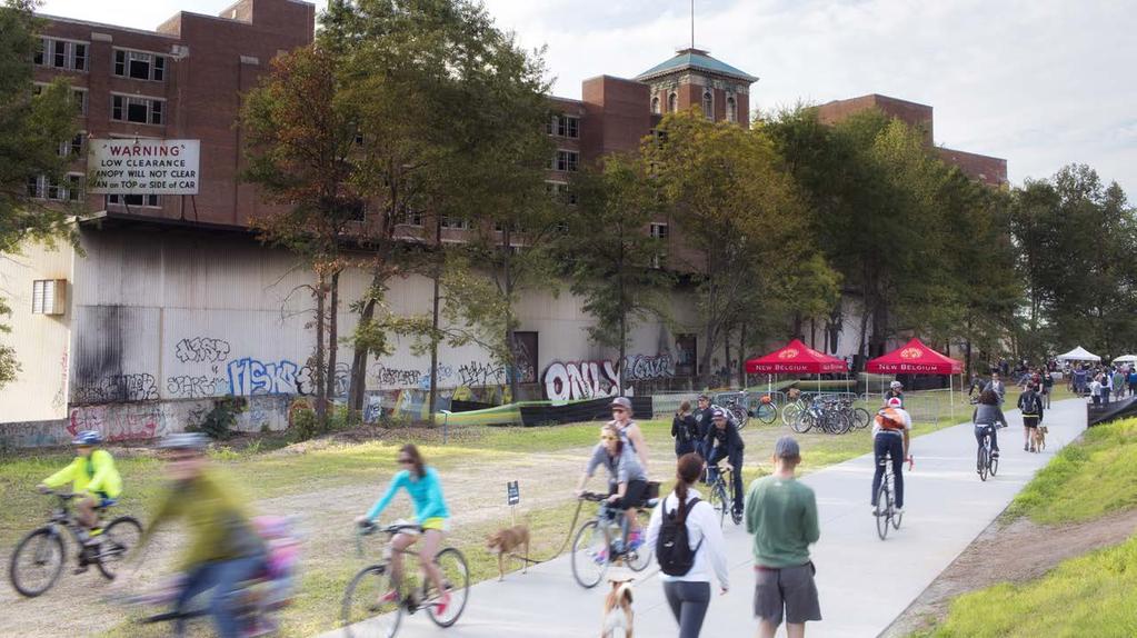
7 Atlanta BeltLine Westside Trail MAJOR PARTNER In September 2017, the three-mile Atlanta BeltLine Westside Trail opened, completing a highly anticipated link in the overall BeltLine system. This segment of the multi-use trail connects several historic Southwest Atlanta neighborhoods to transit, parks, and schools while providing a safe bicycle and pedestrian corridor. The Westside Trail connects over 40 acres of greenspace and contains an urban agriculture farm at the trail s southern end. BEFORE: JUNE 2014 AFTER: AUGUST 2017 GRAND OPENING Images courtesy Atlanta BeltLine 2017 ANNUAL BICYCLE REPORT 7


8 2017 KEY BICYCLE PROJECTS PATH Parkway MAJOR PARTNERS The PATH Foundation, City of Atlanta, and Georgia Tech partnered to repurpose two southbound lanes of Tech Parkway into a tree-lined protected bikeway, walkway, and landscaped median. The one and a half mile bikeway connects West Midtown, Georgia Tech, the Coca-Cola Company headquarters, and Centennial Olympic Park in Downtown Atlanta. PATH Parkway was named America s Best New Bikeway of 2017 by PeopleForBikes for its visionary design and connections to major activity hubs within the City. CONSTRUCTION AFTER: DECEMBER 2017 AFTER RIBBON CUTTING 8 CITY OF ATLANTA


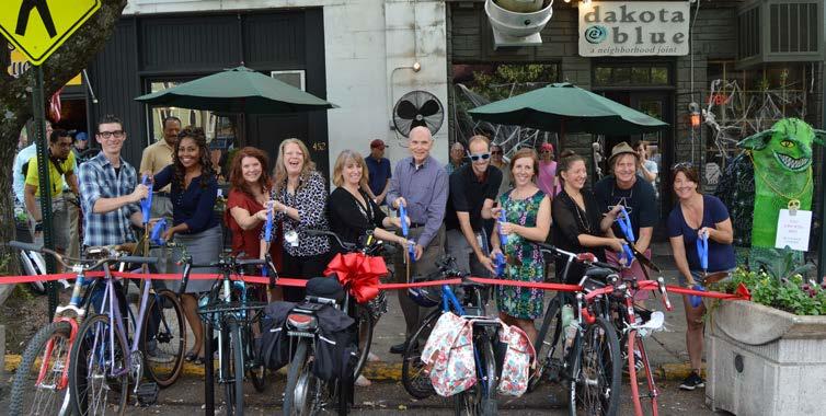
9 Bicycle Art Programs MAJOR PARTNER The Mayor s Office of Cultural Affairs and Department of City Planning collaborated to implement the Mural Bike Rack Project. The goal is to bring greater attention to biking and bike infrastructure through public art and creative placemaking. The project provided 18 local artists with the opportunity to design and paint locally crafted racks. The 18 sculptural bike-shaped racks are installed at various neighborhood nodes. Also working with artists in the Little Five Points community, DCP wrapped three Relay bike share bikes with local art for all riders to enjoy. MURAL BIKE RACK ARTIST & INSTALLATIONS RELAY MURAL UNVEILING EVENT AND BIKE RIDE 2017 ANNUAL BICYCLE REPORT 9
10 TYPES OF ATLANTA BIKEWAYS As a general rule, the level of comfort for people biking is a balance between traffic volumes, speeds, and physical separation from vehicular traffic. On streets with lower traffic volumes and speeds, people can feel safe sharing travel lanes with vehicles. For these streets, shared lane markings can suffice to improve the level of comfort for cyclists. However, along streets with higher traffic volumes and speeds, a dedicated and protected space for people cycling helps improve safety and the perception of safety for interested cyclists. The diagram below, created by Alta Planning and Design, provides a graphic summary of the continuum of on-street marked bikeway facilities. In Atlanta, there is a full range of installed bikeways to create a balanced bikeway network that can accommodate a wider range of rider types. On-Street Marked Bikeway Continuum least protected most protected SHARED LANE MARKINGS BIKE LANE BUFFERED BIKE LANE Centerline of pavement marking placed at least 4 from curb CYCLE TRACK: At-grade, protected with parking CYCLE TRACK: Raised and curb separated CYCLE TRACK: At-grade, protected with flexible bollards P CYCLE TRACK: Raised and protected Complete curb separation or optional mountable curb P P Travel Lane 4 Min. SideWalk Positions bicyclists in the travel lane Alerts motorists to the presence of bicyclists Encourages bicyclists to ride an appropriate distance away from the door zone on streets with parking Should never be used as a replacement for bicycle lanes Travel Lane 5-7 SideWalk Exclusive bicycle travel lane increases safety and promotes proper riding Reduces possibility that motorists will stray into bicyclists path Visual reminder of bicyclists right to the road 6 width recommended. 5 width in constrained locations Bike lanes wider than 7 may encourage vehicle loading in bike lane Travel Lane SideWalk Provides cushion of space to mitigate friction with motor vehicles on streets with frequent or fast motor vehicle traffic Allows bicyclists to pass one another or avoid obstacles without encroaching into the travel lane Increases motorist shy distance from bicyclists in the bike lane Requires additional roadway space and maintenance Reduces risk of dooring compared to a bike lane Parking Lane SideWalk Dedicates and protects space for bicyclists and improves perceived comfort and safety Reduces risk of dooring compared to a bike lane, and eliminates of the risk of a doored cyclist being run over by a motor vehicle Low implementation cost through use of existing pavement using parking lane as a barrier Use along roadways with high motor vehicle volumes and/or speeds Best on streets with parking lanes with a high occupancy rate Travel Lane SideWalk Provides similar benefits as a cycle track with an on-street parking buffer Best used on roads with high speeds and long distances between intersections and driveways Innovative bicycle-friendly design needed at intersections to reduce conflicts between turning motorists and bicyclists Travel Lane SideWalk Change in level clearly demarcates space for different users and reduces conflicts between bicyclists and pedestrians Where bicyclists may enter or leave the cycle track, or where motorists cross at a driveway, the curb should be mountable with a small 45 degree ramp, allowing cyclist turning movements Travel Lane SideWalk Cycle track should be two or three inches above street-level, and the sidewalk should be an additional two to three inches above cycle track Maintenance of the cycle track requires specialized sweepers Where opportunities exist, the buffer zone may be expanded to include bicycle parking Width should never be taken from the pedestrian zone to make room for a cycle track *Protected bicycle lanes and cycletracks are terms that are used interchangeably. 10 CITY OF ATLANTA
11 CHOOSING ATLANTA S BIKEWAYS The chart below, created by the National Association of City Transportation Officials (NACTO), provides guidance in choosing a bikeway design that can create an all ages and abilities bicycling environment, based on a street s basic design and motor vehicle traffic conditions such as vehicle speed and volume. This chart should be applied as part of a flexible, results oriented design process on each street, alongside robust analysis of local bicycling conditions. Protected bicycle lanes and cycletracks are terms that are used interchangeably. Target Motor Vehicle Speed * Any Contextual Guidance for Selecting All Ages & Abilities Bikeways Target Max. Motor Vehicle Volume (ADT) Roadway Context Motor Vehicle Lanes Any Key Operational Considerations Any of the following: high curbside activity, frequent buses, motor vehicle congestion, or turning conflicts All Ages & Abilities Bicycle Facility Protected Bicycle Lane < 10 mph Less relevant Pedestrians share the roadway No centerline, or single lane 20 mph 1,000 2,000 one-way < 50 motor vehicles per hour in 500 1,500 the peak direction at peak hour Shared Street Bicycle Boulevard 25 mph 1,500 3,000 3,000 6,000 Greater than 6,000 Any Single lane each direction, or single lane one-way Multiple lanes per direction Low curbside activity, or low congestion pressure Conventional or Buffered Bicycle Lane, or Protected Bicycle Lane Buffered or Protected Bicycle Lane Protected Bicycle Lane Greater than 26 mph 6,000 Single lane each direction Multiple lanes per direction Low curbside activity, or low congestion pressure Protected Bicycle Lane, or Reduce Speed Protected Bicycle Lane, or Reduce to Single Lane & Reduce Speed Greater than 6,000 Any Any Protected Bicycle Lane, or Bicycle Path High-speed limited access roadways, natural corridors, or geographic edge conditions with limited conflicts Any High pedestrian volume Low pedestrian volume Bike Path with Separate Walkway or Protected Bicycle Lane Shared-Use Path or Protected Bicycle Lane * While posted or 85th percentile motor vehicle speed are commonly used design speed targets, 95th percentile speed captures high-end speeding, which causes greater stress to bicyclists and more frequent passing events. Setting target speed based on this threshold results in a higher level of bicycling comfort for the full range of riders. Setting 25 mph as a motor vehicle speed threshold for providing protected bikeways is consistent with many cities' traffic safety and Vision Zero policies. However, some cities use a 30 mph posted speed as a threshold for protected bikeways, consistent with providing Level of Traffic Stress level 2 (LTS 2) that can effectively reduce stress and accommodate more types of riders. 18 Operational factors that lead to bikeway conflicts are reasons to provide protected bike lanes regardless of motor vehicle speed and volume ANNUAL BICYCLE REPORT 11

12 CITYWIDE BICYCLE DATA In 2008, the City of Atlanta Department of City Planning developed and adopted Atlanta s first comprehensive transportation plan. The content and goals of this foundational plan set the stage for where we are now. With the support of the Mayor, the Atlanta City Council, and other stakeholders, the City installed the first protected bike lane in The success of the 10th Street protected bike lane motivated our largest growth of bikeways and bike ridership. Today Atlanta has just over 116 miles of bikeways built - doubling Atlanta s mileage since Another 84 miles of infrastructure are planned for future implementation. These improvements to the bike network are important because they highlight the City s commitment to improving citizens health, providing affordable transportation options, and becoming a bike-friendly city. 180 Atlanta s Bikeway Mileage MILES Total Mileage by Type Bike Lane 46 Multi-Use Path 42 Shared Lane Marking 16 Buffered Bike Lane 5 Cycletrack 4 Uphill Bike Lane/Downhill Shared Bike Counter Daily Ridership Averages Bike Counter Monthly Ridership Counts COUNTERS INSTALLED IN th Street & Monroe Drive th Street & Myrtle Street 507 5th Street (Tech Square) 287 Peachtree Street 119 Peachtree Center Avenue 102 COUNTERS INSTALLED IN 2017 Edgewood Avenue 246 Hosea Williams Drive 51 Murphy Avenue 28 Westview Drive 6 TOTAL COUNTS 90,000 80,000 70,000 60,000 50,000 40,000 30,000 20,000 10,000 JAN FEB MAR APR MAY JUN JUL AUG SEP OCT NOV DEC 12 CITY OF ATLANTA

13 CITYWIDE BICYCLE DATA Below is a map of all installed bikeways and the locations of the automatic bike counters. While this is the start of a strong network, we must work to connect existing bikeways to make biking safer and more enjoyable in Atlanta. Current Bikeways Map Bicycle Mode Share 2016: 2030 TARGET: 1.4% 4% BIKE COUNTER LOCATIONS COUNTER INSTALLED IN 2016 COUNTER INSTALLED IN 2017 LEGEND BIKE LANE MULTI-USE PATH CYCLETRACK SHARED LANE MARKING BUFFERED BIKE LANE UPHILL BIKE LANE ATLANTA BELTLINE CORRIDOR 5th Street (Tech Square) 10th Street & Myrtle Street 10th Street & Monroe Drive Peachtree Street Peachtree Center Avenue Westview Drive Hosea Williams Drive Murphy Avenue Edgewood Avenue 2017 ANNUAL BICYCLE REPORT 13


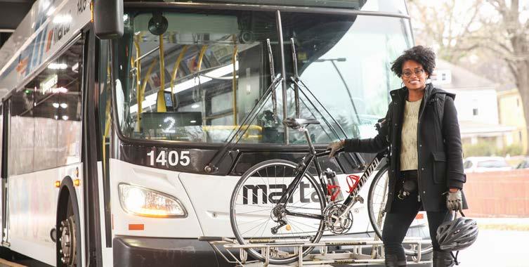
14 RELAY BIKE SHARE The City launched Relay Bike Share in partnership with CycleHop and Georgia s Own Credit Union in June 2016 with 100 bikes at 10 stations in Downtown Atlanta. Since then, Relay has expanded to 500 bikes at 75 stations connecting 15 neighborhoods. The popular program provides a healthy and enjoyable transportation solution allowing residents and visitors alike to travel around Atlanta by bike. The City s bike share program uses Social Bicycles technology which allows riders to lock both at stations across Atlanta and to publicly-accessible bike racks. This flexibility is key to the success of the system. To date more than 25,000 people have ridden Relay Bike Share. Relay Totals Since June 2016 Launch 86,370 48, ,395 TRIPS HOURS MILES Average Relay Trip: 34 MINUTES 2.2 MILES Find out more at Bike Share Champions Program The City of Atlanta, Atlanta Bicycle Coalition, Relay Bike Share, WeCycle Atlanta, Urban Perform, Red, Bike & Green Atlanta, Annie Casey Foundation, Better Bike Share Partnership and HABESHA have worked collectively to implement two years of the Atlanta Bike Share Champion program. The program s goal is to work directly with Westside and NPU V community members on bike share station location selection, education and bike safety via the employment of residents. Program Highlights COMMUNITY MEMBERS HIRED FOR PAID OUTREACH HOURS OF OUTREACH AND EDUCATION PROVIDED The placement of Relay stations suggest that only 2% of riders would live in Westside neighborhoods. Due to the work of the Bike Share Champions, westside residents account for 4% of actual ridership. Over the next two years, the City plans to expand the bike share program to more westside and southern neighborhohoods 14 CITY OF ATLANTA


15 RELAY BIKE SHARE MAP Top 10 Relay Hubs Average Total Rentals per Month ATLANTIC STATION GEORGIA TECH MIDTOWN 1 Piedmont Park & Eastside BeltLine Historic Fourth Ward Park Piedmont Park West Greenwood Ave BeltLine King of Pops Piedmont Park East Irwin & Eastside BeltLine Tech Square Georgia Tech - Clough Building Outwright Station 252 OLD FOURTH WARD VINE CITY DOWNTOWN ATLANTA UNIVERSITY CENTER REYNOLDSTOWN WEST END GRANT PARK N 1 mi RELAY BIKE HUB LOCATION ATLANTA BELTLINE CORRIDOR 10, Relay Membership Totals by Type TOTAL MEMBERSHIPS 5,000 MEMBERSHIP TYPE TOTAL Other 368 Student 727 Annual 357 Monthly 878 Pay-As-You-Go 6721 TOTAL JAN FEB MAR APR MAY JUN JUL AUG SEP OCT NOV DEC 2017 ANNUAL BICYCLE REPORT 15


16 THE FUTURE OF ATLANTA BIKEWAYS The Department of City Planning (DCP) is responsible for guiding the future of Atlanta s transportation system. The Atlanta City Design highlights our need to prioritize people in the design of Atlanta s physical form. In 2017, DCP engaged Atlantans citywide to develop the Atlanta Transportation Plan which has been created to operationalize the Access Strategies of City Design. Cycle Atlanta 1.0 and 2.0 Studies are implementation strategies to build a network of bikeways inside the Atlanta Beltline and to MARTA Stations, respectively. This report documents the City s progress to complete these bikeway networks. Cycle Atlanta 1.0 In 2013, the City set out to define the future of bikeways inside the Atlanta BeltLine. The study leveraged the energy around the country for better protected bike lanes, trails, and new bike intersection treatments. The Cycle Atlanta 1.0 Study was completed in Since then the City has installed and funded 94% of the planned bikeways. PROGRESS THROUGH 2017 COMPLETED 10 mi FUNDED 20 mi PLANNED 2 mi TOTAL 32 mi 16 CITY OF ATLANTA

17 Cycle Atlanta 2.0 Building on the success of Cycle Atlanta 1.0, the City kicked off Cycle Atlanta 2.0 in March This study focused on how to build a network of bikeways to six MARTA stations to increase bike usage and transit ridership, and to improve bike access to the stations. Hamilton E. Holmes, West Lake, Oakland City, West End, Edgewood/Candler Park and Inman Park/ Reynoldstown Stations were studied. Because of this study, bike lanes were added to the Sylvan Road resurfacing project currently underway. PROGRESS THROUGH 2017 COMPLETED 1.8 mi FUNDED 13.5 mi PLANNED 26.7 mi TOTAL 42.0 mi 2017 ANNUAL BICYCLE REPORT 17

18 18 CITY OF ATLANTA
19 ACKNOWLEDGMENTS The Department of City Planning would like to thank everyone working to create safer bicycle infrastructure and more robust bicycle engagement programs across Atlanta. Without the efforts and dedication of many City departments, external stakeholders and engaged communities, we would have not achieve the accomplishments detailed in this report. Many thanks to the dedicated staff at the following: ATLANTA BELTLINE INC ATLANTA BICYCLE COALITION ATLANTA FALCONS YOUTH FOUNDATION ATLANTA REGIONAL COMMISSION BUCKHEAD COMMUNITY IMPROVEMENT DISTRICT CENTRAL ATLANTA PROGRESS CYCLEHOP GEORGIA BIKES GEORGIA DEPARTMENT OF TRANSPORTATION LIVABLE BUCKHEAD MARTA MIDTOWN ALLIANCE NATIONAL ASSOCIATION OF CITY TRANSPORTATION OFFICIALS PARK PRIDE PATH FOUNDATION DEPARTMENT OF PUBLIC WORKS RENEW ATLANTA-TSPLOST DEPARTMENT OF WATERSHED MANAGEMENT Special thanks to MailChimp and the Atlanta Bicycle Coalition who provided funding for a large portion of the automated bike counters. This report was produced by the Department of City Planning Office of Mobility Planning Staff including Chris McIntosh, Amelia Kane, Andrew Walters, Becky Katz, Crystal Griggs-Epps, James Washington, Janide Sidifall, Jason Morgan, Jordan Dowdy, and Monique Forte ANNUAL BICYCLE REPORT 19
20
City of Atlanta-MARTA Sales Tax Referendum Draft Project List. Atlanta City Council Work Session May 19, 2016
 1 City of Atlanta-MARTA Sales Tax Referendum Draft Project List Atlanta City Council Work Session May 19, 2016 2 SB 369 - MARTA Sales tax for up to 0.50% is allowed in the City of Atlanta for MARTA Purpose
CITY OF BLOOMINGTON COMPLETE STREETS POLICY
 CITY OF BLOOMINGTON COMPLETE STREETS POLICY POLICY OBJECTIVE: The City of Bloomington will enhance safety, mobility, accessibility and convenience for transportation network users of all ages and abilities,
Perryville TOD and Greenway Plan
 Perryville TOD and Greenway Plan Greenway Glossary Pathway: A bicycle and pedestrian path separated from motorized vehicular traffic by an open space, barrier or curb. Multi-use paths may be within the
CONNECTING PEOPLE TO PLACES
 CONNECTING PEOPLE TO PLACES 82 EAST BENCH MASTER PLAN 07 Introduction The East Bench transportation system is a collection of slow moving, treelined residential streets and major arteries that are the
Corpus Christi Metropolitan Transportation Plan Fiscal Year Introduction:
 Introduction: The Safe, Accountable, Flexible, Efficient Transportation Equity Act: A Legacy for Users (SAFETEA-LU) has continued the efforts started through the Intermodal Surface Transportation Efficiency
Bicycle Master Plan Goals, Strategies, and Policies
 Bicycle Master Plan Goals, Strategies, and Policies Mobilizing 5 This chapter outlines the overarching goals, action statements, and action items Long Beach will take in order to achieve its vision of
EXECUTIVE SUMMARY. Vision
 Vision Walking and bicycling in Salt Lake City will be safe, convenient, comfortable, and viable transportation options that connect people to places, foster recreational and economic development opportunities,
Complete Streets. Designing Streets for Everyone. Sarnia
 Complete Streets Designing Streets for Everyone Sarnia Complete Streets ~ Sarnia ~ 2018 Introduction Our City is made up of a network of streets that we use to go for a walk, cycle to work, drive to the
WALKNBIKE DRAFT PLAN NASHVILLE, TENNESSEE EXECUTIVE SUMMARY NASHVILLE, TENNESSEE
 NASHVILLE, TENNESSEE EXECUTIVE SUMMARY Executive Summary A world-class multi-modal transportation system is essential to a vibrant city and better quality of life. -Mayor Barry The WalknBike plan aims
Living Streets Policy
 Living Streets Policy Introduction Living streets balance the needs of motorists, bicyclists, pedestrians and transit riders in ways that promote safety and convenience, enhance community identity, create
Broad Street Bicycle Boulevard Design Guidelines
 Broad Street Bicycle Boulevard Design Guidelines Building from the strategies introduced in the 2013 Bicycle Transportation Plan and community input received thus far, City Transportation Staff have identified
City of Wilsonville 5 th Street to Kinsman Road Extension Project
 City of Wilsonville 5 th Street to Kinsman Road Walking Tour & Neighborhood Workshop Summary Report Public Outreach Overview On July 18 th, 2017, the City of Wilsonville hosted a neighborhood walking tour
RESOLUTION NO ?? A RESOLUTION OF THE CITY OF NEPTUNE BEACH ADOPTING A COMPLETE STREETS POLICY
 RESOLUTION NO. 2018-?? A RESOLUTION OF THE CITY OF NEPTUNE BEACH ADOPTING A COMPLETE STREETS POLICY WHEREAS, safe, convenient, and accessible transportation for all users is a priority of the City of Neptune
Chapter 5. Complete Streets and Walkable Communities.
 Chapter 5. Complete Streets and Walkable Communities. 5.1 Description of Complete Streets. Cities throughout the world, and specifically the United States, are coming to embrace a new transportation and
TOWN OF PORTLAND, CONNECTICUT COMPLETE STREETS POLICY
 TOWN OF PORTLAND, CONNECTICUT COMPLETE STREETS POLICY I. VISION, GOALS & PRINCIPLES VISION To improve the streets of Portland making them safer and more accessible for all users including pedestrians,
CONNECTIVITY PLAN. Adopted December 5, 2017 City of Virginia Beach
 CONNECTIVITY PLAN Adopted December 5, 2017 City of Virginia Beach CONTENTS 1.0 Background & Purpose... 2 2.0 Existing Inventory & Analysis... 3 ViBe District Existing Walking Conditions... 4 3.0 ViBe District
Complete Streets Chicago: Data Driven Design. Luann Hamilton Deputy Commissioner
 Complete Streets Chicago: Data Driven Design Luann Hamilton Deputy Commissioner AGENDA Chicago s goals Complete Streets & Sustainable Infrastructure Guides Data-Driven Planning Setting goals Scoping/research
Off-road Trails. Guidance
 Off-road Trails Off-road trails are shared use paths located on an independent alignment that provide two-way travel for people walking, bicycling, and other non-motorized users. Trails specifically along
REGIONAL BICYCLE AND PEDESTRIAN DESIGN GUIDELINES
 REGIONAL BICYCLE AND PEDESTRIAN DESIGN GUIDELINES November 16, 2011 Deb Humphreys North Central Texas Council of Governments Bicycle and Pedestrian Advisory Committee Snapshot of the Guide 1. Introduction
Chapter 2. Bellingham Bicycle Master Plan Chapter 2: Policies and Actions
 Chapter 2 Bellingham Bicycle Master Plan Chapter 2: Policies and Actions Chapter 2: Policies and Actions The Bicycle Master Plan provides a road map for making bicycling in Bellingham a viable transportation
Chapter 7. Transportation. Transportation Road Network Plan Transit Cyclists Pedestrians Multi-Use and Equestrian Trails
 Chapter 7 Transportation Transportation Road Network Plan Transit Cyclists Pedestrians Multi-Use and Equestrian Trails 7.1 TRANSPORTATION BACKGROUND The District of Maple Ridge faces a number of unique
AMATS Complete Streets Policy
 AMATS Complete Streets Policy Table of Contents: Section 1. Definition of Complete Streets Section 2. Principles of Complete Streets Section 3. Complete Streets Policy Section 4. Consistency Section 5.
Solana Beach Comprehensive Active Transportation Strategy (CATS)
") Solana Beach Comprehensive Active Transportation Strategy (CATS) 3.0 Goals & Policies The Solana Beach CATS goals and objectives outlined below were largely drawn from the Solana Beach Circulation Element
Solana Beach Comprehensive Active Transportation Strategy (CATS) 3.0 Goals & Policies The Solana Beach CATS goals and objectives outlined below were largely drawn from the Solana Beach Circulation Element
SPEED MANAGEMENT FOR VISION ZERO
 SPEED MANAGEMENT FOR VISION ZERO LUANN HAMILTON, DEPUTY COMMISSIONER FOR PROJECT DEVELOPMENT CHICAGO DEPARTMENT OF TRANSPORTATION NACTO DESIGNING CITIES 2017 Vision Zero Action Plan Speed management and
CHAPTER 1 INTRODUCTION
 CHAPTER 1 INTRODUCTION Chapter Table of Contents THE 2017 HOUSTON BIKE PLAN 1-1 HOUSTON BIKEWAYS PROGRAM 1-2 HISTORY OF BICYCLE PLANNING IN HOUSTON 1-3 BICYCLE LEVEL OF COMFORT 1-3 EXISTING PLANS, PROGRAMS
Transportation Assessment
 Transportation Assessment Midtown Open House February 10, 2018 Overview Midtown in Focus Overview & Purpose of Today Transportation Assessment overview Summary of Transportation work to date Review & Analysis
FINAL PLAN APPENDIX D CITY OF BERKELEY BIKE PLAN D-1
 CITY OF BERKELEY BIKE PLAN D-1 . Proposed Programs D.1. EDUCATION This appendix presents the recommended bicycle-related programs for the City of Berkeley. The recommendations are organized in four E s:
PEDESTRIAN ACTION PLAN
 ATTACHMENT 2 CITY OF SANTA MONICA PEDESTRIAN ACTION PLAN CITY OF SANTA MONICA PEDESTRIAN ACTION PLAN This page intentionally left blank EXECUTIVE SUMMARY CHAPTER 1 EXECUTIVE SUMMARY Setting the Stage
Proposed. City of Grand Junction Complete Streets Policy. Exhibit 10
 Proposed City of Grand Junction Complete Streets Policy Exhibit 10 1 City of Grand Junction Complete Streets Policy Vision: The Complete Streets Vision is to develop a safe, efficient, and reliable travel
Bikeway action plan. Bicycle Friendly Community Workshop March 5, 2007 Rochester, MN
 Bikeway action plan Summary The was held on March 5, 2007 at the Rochester Mayo Civic Center. The workshop was hosted by Rochester-Olmsted County Planning Department in collaboration with the League of
Tonight is for you. Learn everything you can. Share all your ideas.
 Strathcona Neighbourhood Renewal Draft Concept Design Tonight is for you. Learn everything you can. Share all your ideas. What is Neighbourhood Renewal? Creating a design with you for your neighbourhood.
NM-POLICY 1: Improve service levels, participation, and options for non-motorized transportation modes throughout the County.
 Transportation PRINCE WILLIAM COUNTY 2008 COMPREHENSIVE PLAN NON-MOTORIZED PLAN CONTENTS Goals, Policies, and Action Strategies Table 4 (Bike Facility Classifications and Descriptions) Table 5 (Bike Facility
Non-Motorized Transportation 7-1
 Non-Motorized Transportation 7-1 Transportation facilities no longer mean just accommodating a vehicle powered by a combustion engine. Pedestrian and non-motorized facilities are important modes of travel
Welcome. If you have any questions or comments on the project, please contact:
 Welcome This drop-in public open house is intended to provide information about the Bay Street bike lanes project. This project proposes a dedicated cycling facility along Bay Street between Aberdeen Avenue
Complete Streets Workshop Follow-up. April 27, 2011 Rockledge City Hall
 Complete Streets Workshop Follow-up April 27, 2011 Rockledge City Hall Agenda Complete Streets draft briefing presentation and sample policy language Share your Complete Streets projects and post workshop
City of Novi Non-Motorized Master Plan 2011 Executive Summary
 City of Novi Non-Motorized Master Plan 2011 Executive Summary Prepared by: February 28, 2011 Why Plan? Encouraging healthy, active lifestyles through pathway and sidewalk connectivity has been a focus
Basalt Creek Transportation Refinement Plan Recommendations
 Basalt Creek Transportation Refinement Plan Recommendations Introduction The Basalt Creek transportation planning effort analyzed future transportation conditions and evaluated alternative strategies for
In station areas, new pedestrian links can increase network connectivity and provide direct access to stations.
 The Last Mile Planning for Pedestrians Planning around stations will put pedestrians first. Making walking to stations safe and easy is important; walking will be a part of every rapid transit Accessible
DRAFT - CITY OF MEDFORD TRANSPORTATION SYSTEM PLAN Roadway Cross-Sections
 Roadway Cross-Sections Medford s roadway cross-section standards apply to new and reconstructed roads. The crosssections take into consideration roadway function and operational characteristics, including
Exhibit 1 PLANNING COMMISSION AGENDA ITEM
 Exhibit 1 PLANNING COMMISSION AGENDA ITEM Project Name: Grand Junction Circulation Plan Grand Junction Complete Streets Policy Applicant: City of Grand Junction Representative: David Thornton Address:
We believe the following comments and suggestions can help the department meet those goals.
 The Honorable Secretary Anthony Foxx The Secretary of Transportation United States Department of Transportation 1200 New Jersey Avenue, SE Washington, DC 20590 August 30, 2013 Dear Secretary Foxx, Thank
Complete Streets Training. Georgia Municipal Association June 27, 2016
 Complete Streets Training Georgia Municipal Association June 27, 2016 Overview What are CS? GDOT s Policy Case Study 2 What are Complete Streets? According to the National Complete Streets Coalition, complete
BETHEL ROAD AND SEDGWICK ROAD CORRIDOR STUDY
 DRAFT PLAN City Council Meeting August 14, 2017 STUDY AREA Sedgwick Corridor State Route 160, principal arterial with Class 3 access management designation, commuter and freight route, connection to SR
Welcome! San Jose Avenue Open House August 25, 2015
 Welcome! San Jose Avenue Open House August 25, 2015 Vision Zero The City and County of San Francisco adopted Vision Zero San Francisco Vision Zero High Injury Network as a policy in 2014, committing an
CITY OF COCOA BEACH 2025 COMPREHENSIVE PLAN. Section VIII Mobility Element Goals, Objectives, and Policies
 CITY OF COCOA BEACH 2025 COMPREHENSIVE PLAN Section VIII Mobility Element Goals, Objectives, and Policies Adopted August 6, 2015 by Ordinance No. 1591 VIII MOBILITY ELEMENT Table of Contents Page Number
CURBSIDE ACTIVITY DESIGN
 5 CURBSIDE ACTIVITY DESIGN This chapter provides design guidance for separated bike lanes adjacent to curbside activities including parking, loading and bus stops. Typical configurations are presented
Bicycle Friendly Niagara Falls
 Bicycle Friendly Niagara Falls STAKEHOLDER COMMITTEE MEETING 2 SUPPORTED BY THE OATH COMMUNITY FUND AT THE COMMUNITY FOUNDATION FOR GREATER BUFFALO Develop a Bicycle Master Plan to document the city s
Arlington s Master Transportation Plan
 Arlington s Master Transportation Plan The Master Transportation Plan (MTP) Adopted in eight parts Goals & Policies element and MTP Map adopted in 2007 Bicycle, Pedestrian and Demand and Systems Management
PEDALING FORWARD. A Glance at the SFMTA s Bike Program for SFMTA.COM
 PEDALING FORWARD A Glance at the SFMTA s Bike Program for 2017-2021 SFMTA.COM INTRODUCTION About This Booklet More people from all walks of life see their bicycle as a more convenient way to get where
TRAVEL PLAN: CENTRAL EUROPEAN UNIVERSITY CAMPUS REDEVELOPMENT PROJECT TRAVEL PLAN. Central European University Campus Redevelopment Project.
 TRAVEL PLAN Central European University Campus Redevelopment Project Page 1 Table of Contents Introduction... 3 Background... 7 Building Users... 7 Transportation in Community Consultation... 7 Summary
ACTIVE TRANSPORTATION
 ACTIVE TRANSPORTATION Mobility 2040 Supported Goals Improve the availability of transportation options for people and goods. Support travel efficiency measures and system enhancements targeted at congestion
Bicycle Facilities Planning
 Bicycle Facilities Planning Overview Types of Cyclists Purpose for Riding Types of Facilities Bike Lanes Bicycle Boulevards Cycle Tracks Intersections Signals Signing and Marking Discussion Types of Bicyclists
2. Vision & Goals. Vision. Santa Rosa is a community where walking and bicycling are comfortable and convenient for people of all ages and abilities.
 2. Vision & Goals Overview The goals of the Santa Rosa Bicycle and Pedestrian Master Plan Update reflect the priorities expressed by the community throughout the public outreach phase of this Plan Update.
Active Transportation Facility Glossary
 Active Transportation Facility Glossary This document defines different active transportation facilities and suggests appropriate corridor types. Click on a facility type to jump to its definition. Bike
San Jose Transportation Policy
 San Jose Transportation Policy Protected Intersections in LOS Policies to Support Smart Growth Presented by: Manuel Pineda City of San Jose Department of Transportation Bay Area Map San Francisco Oakland
2014 Bellingham Bicycle Master Plan
 2014 Bellingham Bicycle Master Plan Acknowledgements The City of Bellingham is honored by the commitment of the numerous community members and bicycling enthusiasts who participated in the development
Goodlettsville Bicycle and Pedestrian Plan Executive Summary
 Goodlettsville Bicycle and Pedestrian Plan July 2010 In Cooperation with the Nashville Area Metropolitan Planning Executive Organization Summary Introduction Progressive and forward thinking communities
Community Transportation Plan Acknowledgements
 Community Transportation Plan Acknowledgements The Decatur CTP was developed with participation and guidance from City of Decatur staff, its Resident Boards and Commissions, and numerous residents, business
Transportation Master Plan Advisory Task Force
 Transportation Master Plan Advisory Task Force Network Alternatives & Phasing Strategy February 2016 BACKGROUND Table of Contents BACKGROUND Purpose & Introduction 2 Linking the TMP to Key Council Approved
Dr. M.L. King, Jr. Street North Complete Streets Resurfacing Opportunities HOUSING, LAND USE, AND TRANSPORTATION COMMITTEE MARCH 22, 2018
 Dr. M.L. King, Jr. Street North Complete Streets Resurfacing Opportunities HOUSING, LAND USE, AND TRANSPORTATION COMMITTEE MARCH 22, 2018 What s Happening The City plans to mill and resurface Dr. M.L.
City of Seattle Edward B. Murray, Mayor
 City of Seattle Edward B. Murray, Mayor Department of Transportation Scott Kubly, Director Eastlake Community Council 117 E Louisa St. #1 Seattle, WA 98102-3278 January 28, 2016 RE: Roosevelt to Downtown
Chapter VISION, MISSION, AND GOALS AND OBJECTIVES. Vision. Mission. Goals and Objectives CONNECTING COMMUNITIES ACROSS THE ST.
 VISION, MISSION, AND GOALS AND OBJECTIVES Chapter 3 The Plan s vision, mission, and goals and objectives were developed through a series of interactive exercises with the Citizens Advisory Committee (CAC)
Cycle Track Design Best Practices Cycle Track Sections
 Design Best Practices Sections It is along street segments where the separation and protection methods of cycle tracks offer more comfort than conventional bicycle lanes, and are more attractive to a wide
Bicycle and Pedestrian Plans and Improvements
 Bicycle and Pedestrian Plans and Improvements Presented to the City Council By Randle Harwood, Planning and Development, and Richard Zavala, Parks and Community Services September 24, 2013 Purpose Review
Hennepin County Bicycle and Pedestrian Planning
 Hennepin County Bicycle and Pedestrian Planning 1 Value of bicycle and sidewalk systems Safety Livability Mobility Health Personal Finances Economic Sustainability Clean Air Recreation Parking and congestion
MAG Town of Cave Creek Bike Study Task 6 Executive Summary and Regional Significance Report
 Page 1 MAG Town of Cave Creek Bike Study Task 6 Executive Summary and Regional Significance Report August 1, 2012 MAG Project #481 Page 2 Task 6 Executive Summary and Regional Significance Report Introduction
Who is Toole Design Group?
 2018 AASHTO Bike Guide Status Update NCHRP 15 60 Amalia Leighton Cody, PE, AICP & Kenneth Loen, PE Washington APWA October 4, 2018 Who is Toole Design Group? TDG is a full service engineering, planning
SAN FRANCISCO MUNICIPAL TRANSPORTATION AGENCY
 THIS PRINT COVERS CALENDAR ITEM NO. : 12 DIVISION: Sustainable Streets BRIEF DESCRIPTION: SAN FRANCISCO MUNICIPAL TRANSPORTATION AGENCY Approving various bicycle improvements and traffic modifications
Edgewood Kirkwood Grant Park Glenwood Park Cabbagetown East Lake Oakhurst Reynoldstown East Atlanta
 A PA R T N E R S H I P B E T W E E N H O N. N ATA LY N A R C H I B O N G A N D T H E G E O R G I A T E C H S C H O O L O F C I T Y A N D R E G I O N A L P L A N N I N G What We Will Talk About Imagine
Safe Routes to School Action Plan Aberdeen, Idaho
 Background Aberdeen, Idaho is a largely agricultural community of nearly 2,000 people and is located in the southeast portion of the state on the western edge of American Falls Reservoir. The community
Zlatko Krstulich, P.Eng. City of O9awa
 Zlatko Krstulich, P.Eng. City of O9awa 1. Introduction to the Ontario Traffic Manual Series 2. What is OTM Book 18: Bicycle Facilities? 3. Study / Committee Team Members 4. Brief overview of the content
Environment and Public Works Committee Presentation
 Mixed Use Centers Complete Streets Guidelines Project Environment and Public Works Committee Presentation December 10, 2008 Project Objectives: Conduct an inter-departmental and agency process to study
Board-Approved Funding Awards for Cycle 4 Active Transportation Grant Program Projects (in Order of Project Rankings) Approved on
 Approved on") CAPITAL Large Category Projects Board-Approved Funding Awards for Cycle 4 Active Transportation Grant Program Projects (in Order of Project Rankings) Approved on 07-27-18 1 La Mesa University Ave Pedestrian
CAPITAL Large Category Projects Board-Approved Funding Awards for Cycle 4 Active Transportation Grant Program Projects (in Order of Project Rankings) Approved on 07-27-18 1 La Mesa University Ave Pedestrian
Complete Streets Successes, Opportunities, and Challenges
 Complete Streets Successes, Opportunities, and Challenges Juliet Walker, Transportation Planner, City of Portsmouth Rob Houseman, Director of Planning and Development, Town of Wolfeboro Chris Parker, Director
CITY OF GRAND JUNCTION URBAN TRAILS COMMITTEE 2017 ANNUAL REPORT
 CITY OF GRAND JUNCTION URBAN TRAILS COMMITTEE 2017 ANNUAL REPORT INTRODUCTION INTRODUCTION Resolution No. 48 94 created the Grand Junction Trails Board in 1994 as a subcommittee of the Riverfront Commission
Multimodal Through Corridors and Placemaking Corridors
 68 Multimodal Through Corridors and Placemaking Corridors Corridors have different functions in a region. Some corridors are used to get smoothly and rapidly through a region or to get quickly to major
Coquitlam Cross-town Bike Route Improving Bicycle Facilities in a Mature Suburban Environment
 Coquitlam Cross-town Bike Route Improving Bicycle Facilities in a Mature Suburban Environment Sarah Rocchi, Vice-President, Projects, Opus International Consultants (Main Presenter) Catherine Mohoruk,
MTP BICYCLE ELEMENT UPDATE. November 2017
 MTP BICYCLE ELEMENT UPDATE November 2017 TIME FOR AN UPDATE Bicycle Element adopted in July 2008 Almost 10 years old Many planned facilities have been implemented 10 years more experience in planning,
SR 693 (Pasadena Avenue) Corridor Study from Shore Drive South to 66 th Street
 Corridor Study from Shore Drive South to 66 th Street") Welcome and Introduction Sign-in and comment sheets Restrooms and exits Meeting agenda and timeline Meeting goals / expectations Provide input to guide study recommendations Actively participate throughout
Welcome and Introduction Sign-in and comment sheets Restrooms and exits Meeting agenda and timeline Meeting goals / expectations Provide input to guide study recommendations Actively participate throughout
Transportation Planning Division
 Transportation Planning Division Presentation Outline Study Tasks Recap of Previous Meetings Data Collected Focus Areas within Study Limits Design Principles Tool Box Recommended Concepts Schedule Moving
City Snapshot September 27, 2018
 1 City Snapshot September 27, 2018 Respondent Introduction Thank you for providing data for the PlacesForBikes City Rating program! The information you provide will be used to understand the progress your
Shifting Gears for a Healthier City
 Shifting Gears for a Healthier City Mississauga s Cycling Master Plan is an ambitious strategy that sets out to transform Mississauga into a city that is conducive to cycling for daily transportation needs.
Purpose + Need. Connect: Thrive: Develop: < Strengthen the spine of our regional transportation system
 Purpose + Need I-29 NW Barry Road 64/68/72 MAIN STREET Connect: < Strengthen the spine of our regional transportation system Leavenworth Road Parallel Parkway State Avenue 18th Street Expressway Shawnee
Agenda. Overview PRINCE GEORGE S PLAZA METRO AREA PEDESTRIAN PLAN
 PRINCE GEORGE S PLAZA METRO AREA PEDESTRIAN PLAN May 28, 2008 Agenda Welcome and introductions Project overview and issue identification Planning context and strengths Design challenges and initial recommendations
Land Use Bicycle Spaces Required Type Residential
 SAMPLE ORDINANCES AND RESOLUTIONS APPENDIX B SAMPLE BICYCLE PARKING ORDINANCE Land Use Bicycle Spaces Required Type Residential Single Family/Two Family N/A N/A Apartment/Townhome 1 per unit plus 6 space
4 Goals, Objectives & Actions
 Chapter4 4 This chapter presents goals, objectives, and recommended actions to support the vision of making Overland Park a safer and easier place to ride a bicycle. 35 4.1 Recommendations Structure The
BUILDING THE CASE FOR TRAVEL OPTIONS IN WASHING TON COUNTY. Image: Steve Morgan. Image: Steve Morgan
 BUILDING THE CASE FOR TRAVEL OPTIONS IN WASHING TON COUNTY Image: Steve Morgan Image: Steve Morgan Image: TriMet Image: TriMet WHAT ARE TRAVEL OPTIONS PROGRAMS? Travel options programs encourage residents,
Duwamish Way-finding and CTR Report
 V. North Tukwila When the North Tukwila Manufacturing and Industrial Center was designated in 1992 as part of the region s land use and transportation plan, the plan called for the area to set a light-rail
PRINCE GEORGE S PLAZA METRO AREA PEDESTRIAN PLAN
 PRINCE GEORGE S PLAZA METRO AREA PEDESTRIAN PLAN May 28, 2008 Agenda Welcome and introductions Project overview and issue identification Planning context and strengths Design challenges and initial recommendations
2.0 LANE WIDTHS GUIDELINE
 2.0 LANE WIDTHS GUIDELINE Road Engineering Design Guidelines Version 2.0.1 May 2018 City of Toronto, Transportation Services City of Toronto Page 0 Background In early 2014, Transportation Services initiated
COMPLETE STREETS POLICY Exhibit A to Ordinance
 CITY OF WENATCHEE COMPLETE STREETS POLICY Exhibit A to Ordinance 2016-24 Prepared and Reviewed By: City of Wenatchee Community & Economic Development Department City of Wenatchee Public Works Department
Mayor s Bicycle Advisory Council. Wednesday, December 13 th, 2017
 Mayor s Bicycle Advisory Council Wednesday, December 13 th, 2017 Bicyclist Fatalities, Year to Date (January 1 November 30, 2017) - MBAC Briefing Bicyclist Fatality Statistics Year to date total, 2017
Physical Implications of Complete Streets Policies
 Presentation Overview Physical Implications of Complete Norm Cox, ASLA, LLA Landscape Architect Ann Arbor, Michigan, 10:45 to Noon What Are Complete Streets? What Matters to Bicyclists and Pedestrians
FOLSOM-HOWARD STREETSCAPE OVERVIEW
 FOLSOM-HOWARD STREETSCAPE OVERVIEW SoMa residents should have the same kinds of amenities that other neighborhoods have. The Folsom- Howard Streetscape Project will make SoMa more livable by making it
Making Phoenix Streets Complete. City of Phoenix Complete Streets Initiative
 Making Phoenix Streets Complete City of Phoenix Complete Streets Initiative City of Phoenix Planning Commission March 2014 Presentation Outline What are Complete Streets? Benefits of Complete Streets Complete
o n - m o t o r i z e d transportation is an overlooked element that can greatly enhance the overall quality of life for the community s residents.
 N o n - m o t o r i z e d transportation is an overlooked element that can greatly enhance the overall quality of life for the community s residents. 84 Transportation CHAPTER 11 INTRODUCTION Transportation
Small Town & Rural Multimodal Networks
 Small Town & Rural Multimodal Networks Fred Young, PLA Andrea Clinkscales, AICP, PMP Alta Planning + Design Funding Partners Project Team Existing Design Guidance AASHTO Flexibility Guide 2004 AASHTO Bike
Major Bike Routes 102 Avenue Workshop April 21, 2015
 Major Bike Routes 102 Avenue Workshop April 21, 2015 Our Purpose Today Provide context on how Major Bike Routes fit into Edmonton s future Share information on what we heard in our last phase, and how
City of Hamilton s Transportation Master Plan (TMP) Public Consultation 3 December 2015
 Public Consultation 3 December 2015") City of Hamilton s Transportation Master Plan (TMP) Public Consultation 3 December 2015 McPhail Transportation Planning Services Ltd. AGENDA 6:00 7:00 pm Viewing Boards / Q & A with the Team 7:00 7:50
City of Hamilton s Transportation Master Plan (TMP) Public Consultation 3 December 2015 McPhail Transportation Planning Services Ltd. AGENDA 6:00 7:00 pm Viewing Boards / Q & A with the Team 7:00 7:50
Bobbie Walthall. Hi Bobby, please include these comments in tonight s CC packet. Thanks for your consideration, Phil Collison Lawrence Resident
 Bobbie Walthall From: Sent: To: Subject: Phil Collison Tuesday, October 16, 2018 9:44 AM Bobbie Walthall Comments for Agenda item 3 Bike Boulevard Hi Bobby, please include these comments