Edgewood Kirkwood Grant Park Glenwood Park Cabbagetown East Lake Oakhurst Reynoldstown East Atlanta
|
|
|
- Kerry Willis
- 5 years ago
- Views:
Transcription

1 A PA R T N E R S H I P B E T W E E N H O N. N ATA LY N A R C H I B O N G A N D T H E G E O R G I A T E C H S C H O O L O F C I T Y A N D R E G I O N A L P L A N N I N G
2 What We Will Talk About Imagine Memorial as the Spine of a Diverse Urban Experience Outreach the Foundation of Our Efforts Land Use and Development Transportation Connectivity Implementation Next Steps: Livable Centers Initiative
3 Outreach Goals and Outcomes: Listening Incorporating: Existing plans Development initiatives Citizen and stakeholder priorities Launching community-guided implementation strategy
4

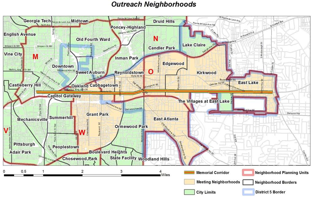
5 Residents writing suggestions on a map at a Reynoldstown Civic Improvement League meeting Outreach Action Plan Attended September and October meetings of many neighborhood associations and five NPUs Encouraged residents to offer feedback, which was foundation of plan Reached out to many public and private sector institutional stakeholders, such as City of Atlanta, GDOT, MARTA, and several developers Solicited feedback from community leaders in early September
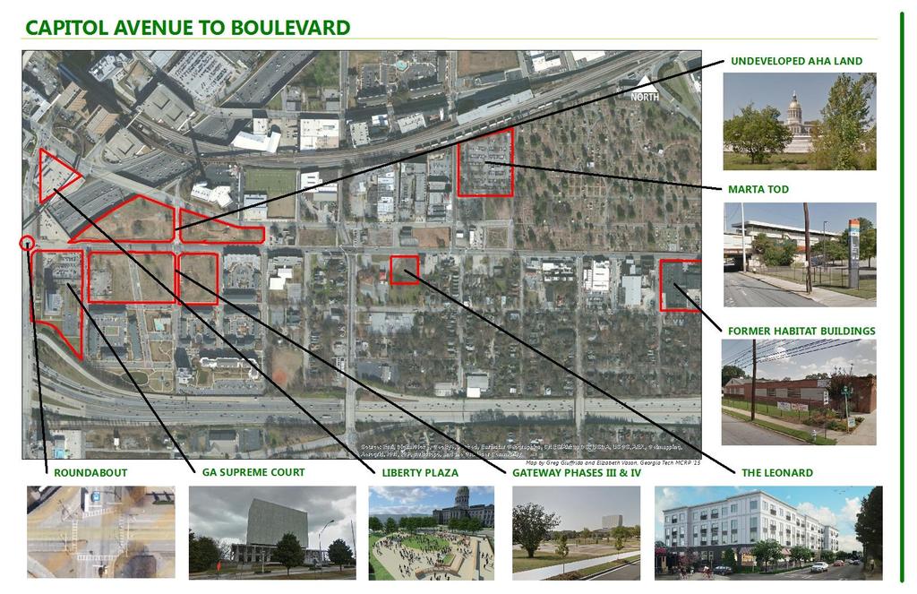
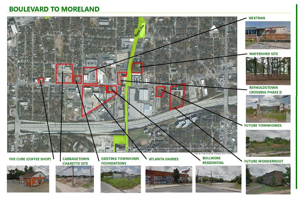
6 Land Use and Development Goals and Outcomes: Identify private and public development planned and under way. Coordinate development with proposed travelway and intersection improvements Consider emerging community needs in future land use planning, zoning, and urban design Support existing and diverse jobs, future job creation Consider shared parking Propose affordable housing strategies, including use of publicly owned property, zoning tools, and tax tools


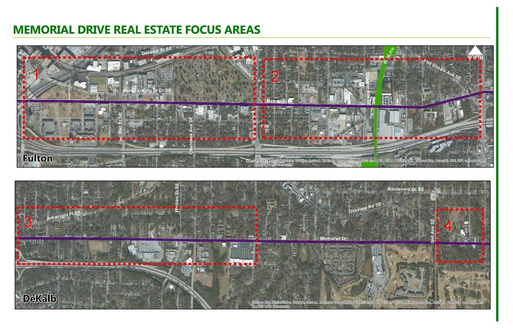
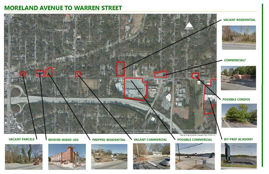
7 Memorial Drive Historical Assets Name changed in 1940 s from Fair Street in reference to Oakland Cemetery and the Battle of Atlanta Oakland Cemetery 1850 Industrial history starting in 1850 s Always a major transportation corridor John F. Faith Elementary Fulton Bag & Cotton Mills Former Standard Oil Station
8
9
10
11
12
 LISC Composite Foreclosure Risk Score, September 2013 (PolicyMap.")
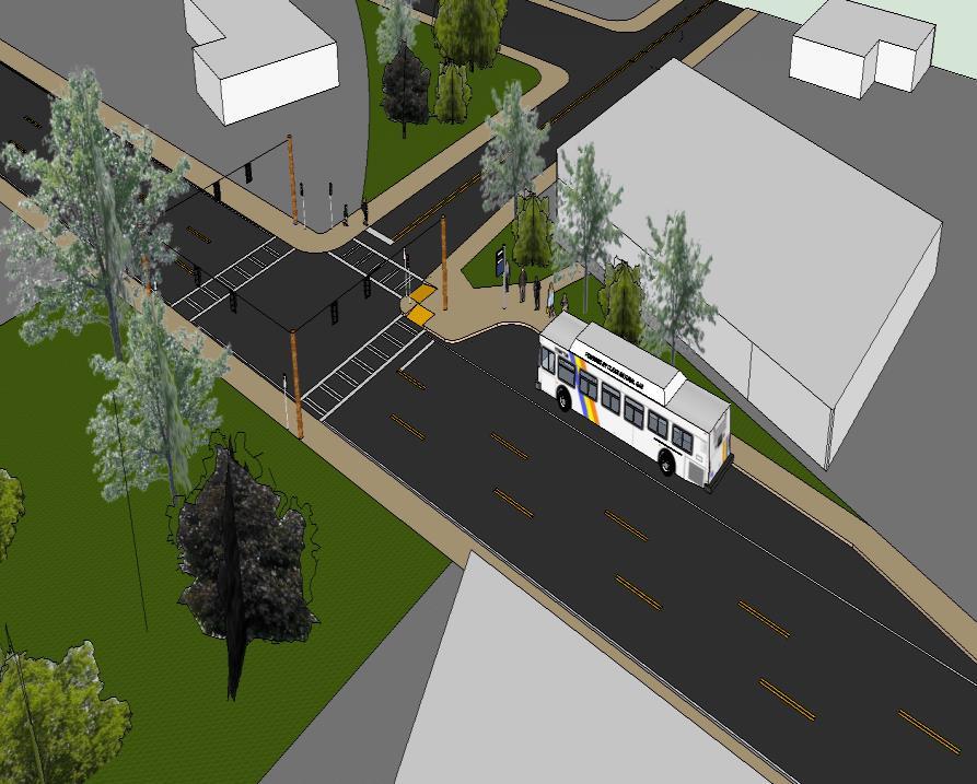
13 Housing Issues Density: More singlefamily homes than rest of city, but that s changing as more multifamily projects come Affordability: Growing market pressure in BeltLine neighborhoods Continued foreclosure vulnerability to south, east (see map) LISC Composite Foreclosure Risk Score, September 2013 (PolicyMap.org) Transit/multimodal accessibility still lags away from MARTA rail Jobs-housing match relatively weak
14 LCI 5-year Housing Strategy LCI PRIORITIES FOR HOUSING: Affordability Economic diversity Job-housing match Aging in place Efficient use of transportation facilities GOALS OF HOUSING STRATEGY Help existing residents stay in their homes if they choose Preserve and improve existing affordable stock options Promote development of new affordable units Promote development that is accessible to transit and other alternative modes Infrastructure and services that allow elderly residents to remain in their communities
15 LCI 5-year Housing Strategy Issue Tools New Affordable Development Seniors Transit Accessibility Future zoning LIHTC, BAHTF, Invest Atlanta tools Low-cost loans, grants for home repairs, energy efficiency Property tax freezes; Shared Housing MARTA TOD program, density bonuses near transit Exploring inclusionary zoning for affordability
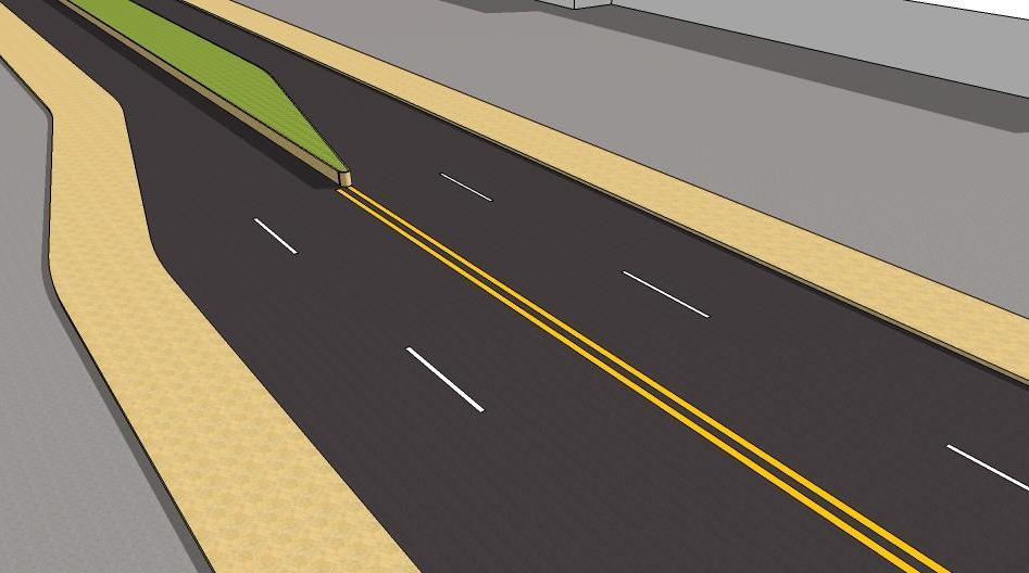
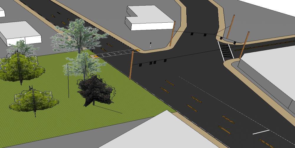
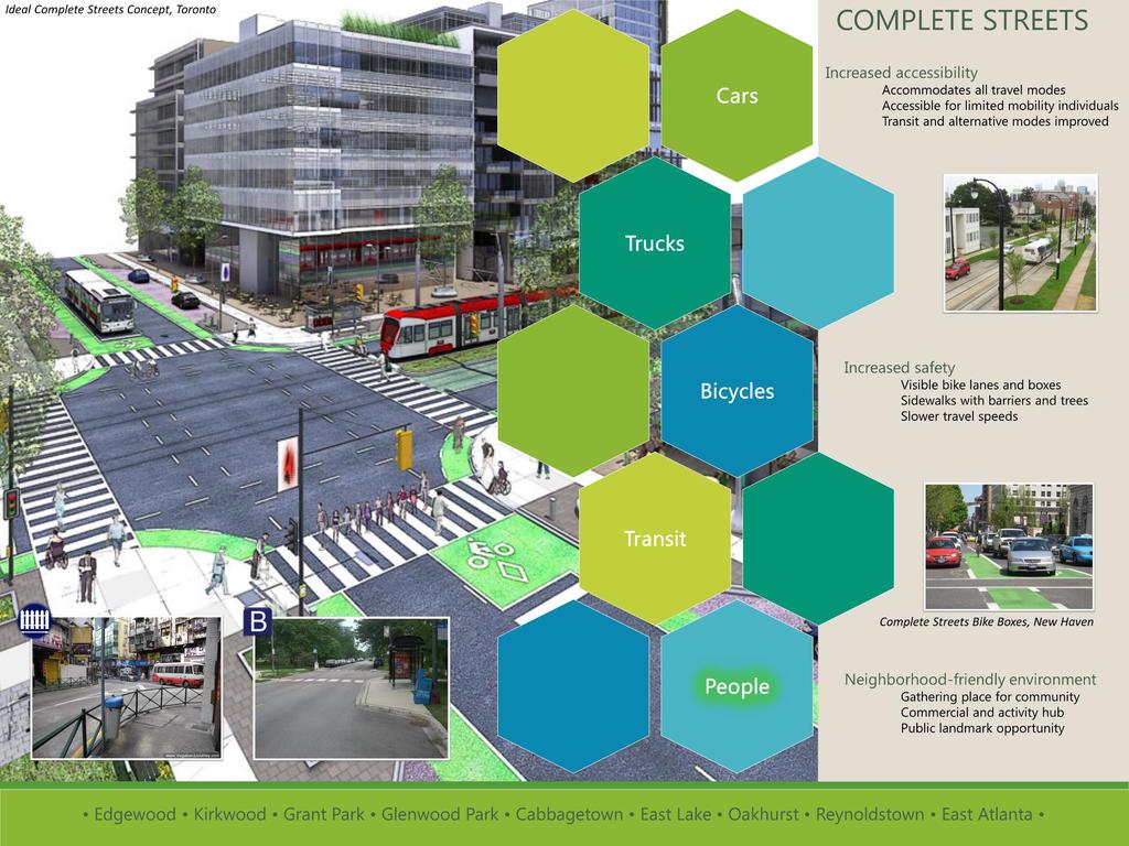
16 Transportation Improvements Goals and Outcomes: Improving pedestrian and vehicular safety Providing consistency in lane treatments Using intersection redesigns to better control access, moderate travel speeds, provide for safer pedestrian and vehicular crossings, and shape new development opportunities Enhancing transit serviceability and experience for now and the future Developing consistent design guides for traffic controls, sidewalks, lighting, signage, transit stops, on-street parking, and tree planting to imagine a grand boulevard over time


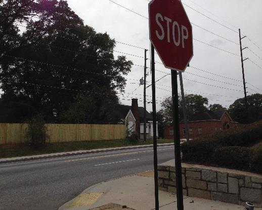
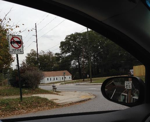
17 Roadway and Intersection Considerations Eastbound perspective from Howard St Existing Configuration Segments Proposed Configuration Segments


18 The Speed Section Examples of speed-reducing strategies Maynard Terrace and Clifton Adequate pedestrian access No disappearing lane at reversible transition Access management Level of Service
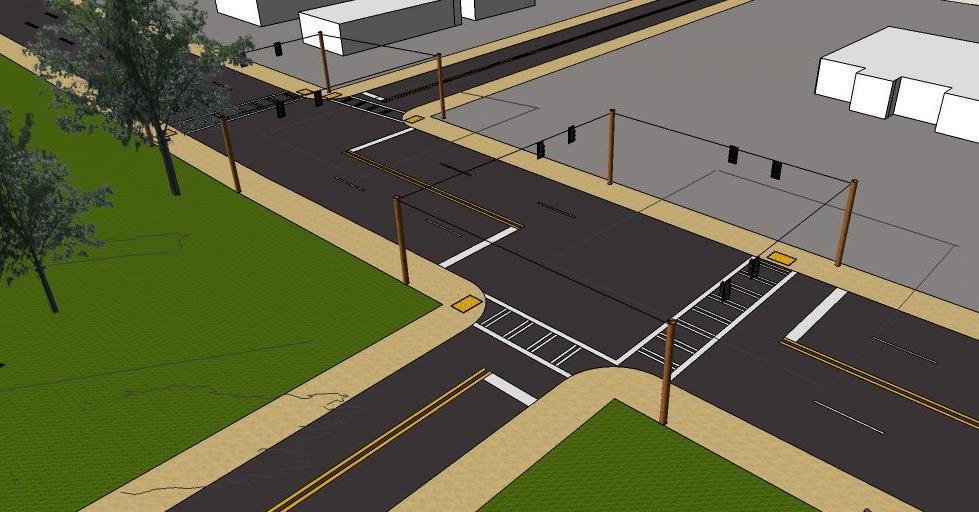
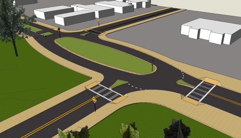
19 Intersection Design Alternatives Moreland Whitefoord Ovalabout
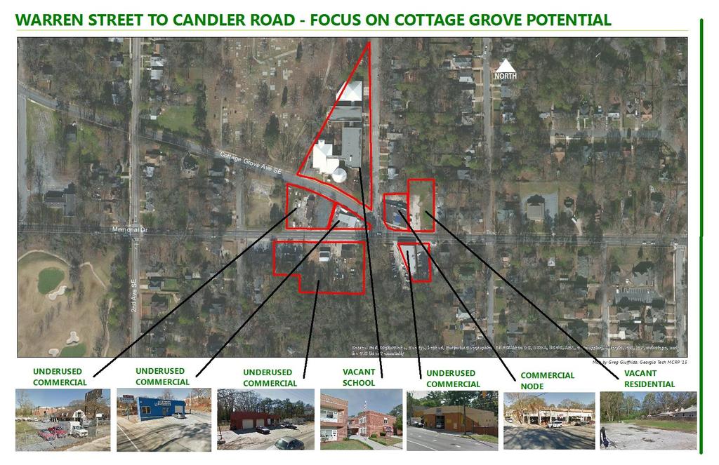
20 Intersection Design Alternatives Cottage Grove Howard St
21 Transit Goals and Outcomes: Recognizing and building on Memorial as an already heavily used transit corridor Establishing a regular sequence of bus shelters and sidewalks to enhance transit functionality and desirability Guide alternatives selection to incorporate optimum visions for the corridor s future for both BeltLine and MARTA BRT long range initiatives


22 Transit Vision Bus Rapid Transit service intersecting Memorial Drive corridor Walkability within ½ mile of transit station Queue jumping lanes
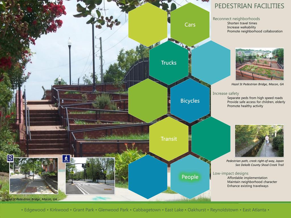
23 Multimodal Connectivity Plan Goals and Outcomes: Developing routes for slower traffic, with emphasis on pedestrian and bicycle modes, paralleling Memorial Drive both to north and south Prioritizing filling in gaps in already existing and planned bike and ped routes Working with intersection designs to establish safer, clearer crossings of both Memorial and I-20 Using enhanced connectivity to highlight access to existing and future neighborhood amenities, like shopping nodes, parks, schools, creek ways, and tree stands Recognizing and connecting the whole corridor to its rich history with interpretive signage and monuments (like the McPherson monument)


24 Public Input Previous Plans Activity Center Analysis Final Connectivity Network
25 Activity Center Analysis Activity centers prioritized as major connections points Activity centers defined by major commercial, recreational, and community facilities Existing and planned developments considered in analysis Existing vs needed bicycle and pedestrian connections Existing and adequate routes considered Activity centers lacking adequate bike/ped connections identified Stakeholder input and previous plans Stakeholder and public input used to identify small scale easy to miss problems Prior studies, neighborhood plan recommendations comprehensively reviewed

26 Activity Center Analysis
27 Bicycle and Pedestrian Connectivity Plan Prioritized safe, efficient routes Corridors parallel to Memorial (Glenwood, Arkwright, etc.) prioritized as bicycle pedestrian primary routes Prioritized expansions and upgrades of existing network Emphasis on community facility access Avoiding vehicle and pedestrian conflict Quieter, safer, slower routes given priority Comprehensive network All activity centers must be accessible from unified route system Bicycles, pedestrians, and other users must be accommodated equally
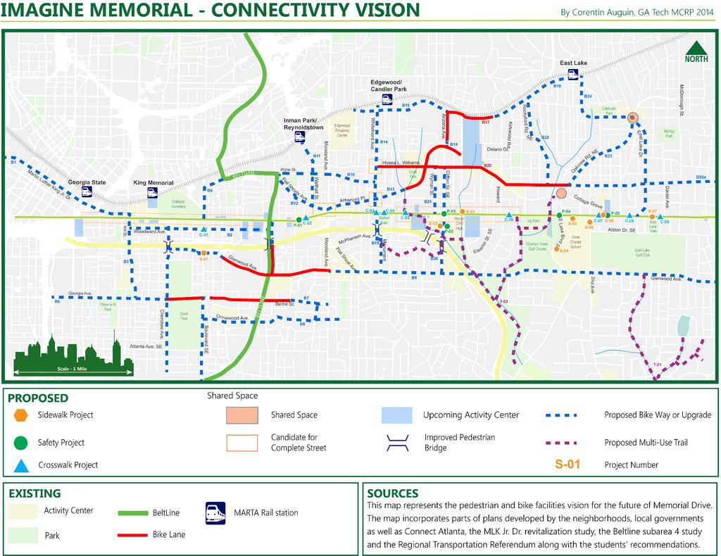
28
29
30
31 Implementation Goals and Outcomes: Identifying next steps Listing private and public projects in the works, with approximate cost ranges and timelines Sharing and updating this information so that private, public, and community stakeholders can inform their judgments on a common information base Identifying and encouraging possible collaborations necessary to move forward, step by step, toward realization of the Imagine Memorial vision Preparing this report in the form of a Livable Centers Initiative funding application to the City and the Atlanta Regional Commission
32 Maintaining Consistent Outreach Phase Dates Purpose Institution for Outreach Create March 2015-March 2016 Educate general public Council district #5 incumbent and neighborhood groups Georgia Tech School of City and Regional Planning (through graduate study program) Work with city and state Media, mostly through real estate trade publications agencies to identify funding opportunities Attract investors for foundation and/or CID Inspire March March 2018 Continue to accelerate Foundation staff program support Council district #5 incumbent Entice investors with corridor potential City of Atlanta Office of Planning and Community Development AND Department of Public Works Emphasize to community the progress that is being made, why, and how it is improving lives Inform March March 2018 Emphasize benefits of Private foundation corridor-wide Council district #5 incumbent improvements Property owner(s) whose lives are positively impacted Create consensus for LCI study area renewal Recreate March 2018 March 2020 Prepare case for LCI renewal along corridor Neighborhood and/or community advocates Business owners who have experienced a return on investment
33 Investment Policy Public/Private Synergies Neighborhood Stakeholders Stakeholder Advisory Committee Review for consistency with LCI goals LCI Study Advocate Development Transportation Improvements Non State Highway Capital City of Atlanta percent match Foundation Finance and Review
34 5 Year Transportation Strategy -- Timeline Moreland Avenue Intersection Improvements Whitefoord-Ovalabout Cottage Grove ROW Improvements Whitefoord-Realignment Whitefoord Signalization Clifton Road Signalization Sidewalk on 2nd Avenue south of Memorial Drive Sidewalk on East Lake Boulevard south of Memorial Drive Memorial Drive Speed Section Improvements 9 -- Sidewalk at East Lake Blvd south of Memorial 8 -- Crosswalk across Memorial Drive to Walker Park 7 -- Crosswalk across Memorial Drive at 3rd Avenue 6 -- Sidewalk along Memorial Drive between Clifton and Clay 5 -- Pedestrian Barriers and Curb Extensions at Memorial Drive 4 -- Sidewalk along Memorial Dr. at East Lake Park 3 -- Enhanced Crosswalk at Memorial Shy Temple CME 2 -- Sidewalks and Barriers near Alonzo Crim High School 1 -- Eastlake Intersection Improvements Dec-14 May-16 Sep-17 Feb-19 Jun-20 Oct-21 Mar-23
35 Five Year Transportation Strategy-- Investments Improvement Investment Moreland Avenue Intersection Improvements $ 148, Whitefoord-Ovalabout $ 1,435, Cottage Grove ROW Improvements $ 2, Whitefoord-Realignment $ 1,107, Whitefoord Signalization $ 315, Clifton Road Signalization $ 499, Sidewalk on 2nd Avenue south of Memorial Drive $ 21, Sidewalk on East Lake Boulevard south of Memorial Drive $ 32, Memorial Drive Speed Section Improvements $ 3,285, Sidewalk at East Lake Blvd south of Memorial $ 32, Crosswalk across Memorial Drive to Walker Park $ 3, Crosswalk across Memorial Drive at 3rd Avenue $ 3, Sidewalk along Memorial Drive between Clifton and Clay $ 11, Pedestrian Barriers and Curb Extensions at Memorial Drive and Clifton $ 20, Sidewalk along Memorial Dr. at East Lake Park $ 98, Enhanced Crosswalk at Memorial Shy Temple CME Church $ 3, Sidewalks and Barriers near Alonzo Crim High School $ 52, Eastlake Intersection Improvements $ 107,760.00
36 Project Team Michael Dobbins, FAICP, FAIA Marcus Ashdown Corentin Auguin Greg Giuffrida Thomas Hamed Bakari Height Wade Ingram Charles Jiang Jason Novsam Ranjani Prabhakar Elizabeth Vason Li Yi Contact:
EXECUTIVE SUMMARY. Edgewood Kirkwood Grant Park Glenwood Park Cabbagetown East Lake Oakhurst Reynoldstown East Atlanta
 EXECUTIVE SUMMARY Edgewood Kirkwood Grant Park Glenwood Park Cabbagetown East Lake Oakhurst Reynoldstown East Atlanta OVERVIEW More than just a road, Memorial Drive is a key corridor with many stakeholders.
Hennepin County Bicycle and Pedestrian Planning
 Hennepin County Bicycle and Pedestrian Planning 1 Value of bicycle and sidewalk systems Safety Livability Mobility Health Personal Finances Economic Sustainability Clean Air Recreation Parking and congestion
TOWN OF PORTLAND, CONNECTICUT COMPLETE STREETS POLICY
 TOWN OF PORTLAND, CONNECTICUT COMPLETE STREETS POLICY I. VISION, GOALS & PRINCIPLES VISION To improve the streets of Portland making them safer and more accessible for all users including pedestrians,
 Time of Change We Are Growing We Are An Attractive Place To Live We Are Age Diverse + Living Longer 50000 40000 30000 20000 10000 0 2010 Census Job Density Housing Sheds Transit Sheds The Project FUNDING
PEDESTRIAN ACTION PLAN
 ATTACHMENT 2 CITY OF SANTA MONICA PEDESTRIAN ACTION PLAN CITY OF SANTA MONICA PEDESTRIAN ACTION PLAN This page intentionally left blank EXECUTIVE SUMMARY CHAPTER 1 EXECUTIVE SUMMARY Setting the Stage
Perryville TOD and Greenway Plan
 Perryville TOD and Greenway Plan Greenway Glossary Pathway: A bicycle and pedestrian path separated from motorized vehicular traffic by an open space, barrier or curb. Multi-use paths may be within the
CONNECTING PEOPLE TO PLACES
 CONNECTING PEOPLE TO PLACES 82 EAST BENCH MASTER PLAN 07 Introduction The East Bench transportation system is a collection of slow moving, treelined residential streets and major arteries that are the
Non-Motorized Transportation 7-1
 Non-Motorized Transportation 7-1 Transportation facilities no longer mean just accommodating a vehicle powered by a combustion engine. Pedestrian and non-motorized facilities are important modes of travel
MASTER BICYCLE AND PEDESTRIAN PLAN
 VILLAGE OF NORTHBROOK MASTER BICYCLE AND PEDESTRIAN PLAN DRAFT PLAN OPEN HOUSE May 2, 2018 AGENDA 1. Community Engagement 2. Vision and Goals 3. General Structure of Plan 4. Recommendations Overview 5.
Goal 3: Foster an environment of partnerships and collaboration to connect our communities and regions to one another.
 Non-Motorized Transportation Plan (NMTP) Draft Vision, Goal and,, Tri-County Regional Planning Commission (TCRPC) Purpose The purpose of the Tri-County Regional Planning Commission (TCRPC) Non-Motorized
Transportation Planning Division
 Transportation Planning Division Presentation Outline Study Tasks Recap of Previous Meetings Data Collected Focus Areas within Study Limits Design Principles Tool Box Recommended Concepts Schedule Moving
Bicycle Master Plan Goals, Strategies, and Policies
 Bicycle Master Plan Goals, Strategies, and Policies Mobilizing 5 This chapter outlines the overarching goals, action statements, and action items Long Beach will take in order to achieve its vision of
Chapter 5 Future Transportation
 Chapter 5 Future Transportation The Future Land Use Plan identifies the desired land use designations. The land uses desired for Crozet depend, in large part, on the success of the transportation system,
Proposed. City of Grand Junction Complete Streets Policy. Exhibit 10
 Proposed City of Grand Junction Complete Streets Policy Exhibit 10 1 City of Grand Junction Complete Streets Policy Vision: The Complete Streets Vision is to develop a safe, efficient, and reliable travel
CITY OF BLOOMINGTON COMPLETE STREETS POLICY
 CITY OF BLOOMINGTON COMPLETE STREETS POLICY POLICY OBJECTIVE: The City of Bloomington will enhance safety, mobility, accessibility and convenience for transportation network users of all ages and abilities,
WALKNBIKE DRAFT PLAN NASHVILLE, TENNESSEE EXECUTIVE SUMMARY NASHVILLE, TENNESSEE
 NASHVILLE, TENNESSEE EXECUTIVE SUMMARY Executive Summary A world-class multi-modal transportation system is essential to a vibrant city and better quality of life. -Mayor Barry The WalknBike plan aims
RESOLUTION NO ?? A RESOLUTION OF THE CITY OF NEPTUNE BEACH ADOPTING A COMPLETE STREETS POLICY
 RESOLUTION NO. 2018-?? A RESOLUTION OF THE CITY OF NEPTUNE BEACH ADOPTING A COMPLETE STREETS POLICY WHEREAS, safe, convenient, and accessible transportation for all users is a priority of the City of Neptune
Executive Summary Route 30 Corridor Master Plan
 Route Corridor Master Plan Project Overview The Route Corridor Master Plan is a coordinated multimodal transportation and land use plan for the entire stretch of Route through East Whiteland Township,
SR 693 (Pasadena Avenue) Corridor Study from Shore Drive South to 66 th Street
 Corridor Study from Shore Drive South to 66 th Street") Welcome and Introduction Sign-in and comment sheets Restrooms and exits Meeting agenda and timeline Meeting goals / expectations Provide input to guide study recommendations Actively participate throughout
Welcome and Introduction Sign-in and comment sheets Restrooms and exits Meeting agenda and timeline Meeting goals / expectations Provide input to guide study recommendations Actively participate throughout
City of Novi Non-Motorized Master Plan 2011 Executive Summary
 City of Novi Non-Motorized Master Plan 2011 Executive Summary Prepared by: February 28, 2011 Why Plan? Encouraging healthy, active lifestyles through pathway and sidewalk connectivity has been a focus
Chapter 7. Transportation. Transportation Road Network Plan Transit Cyclists Pedestrians Multi-Use and Equestrian Trails
 Chapter 7 Transportation Transportation Road Network Plan Transit Cyclists Pedestrians Multi-Use and Equestrian Trails 7.1 TRANSPORTATION BACKGROUND The District of Maple Ridge faces a number of unique
STONY PLAIN ROAD STREETSCAPE
 Jasper Place Revitalization Strategy: Vision The people involved in the Jasper Place Revitalization Strategy envision: Goal 1: Feeling safe in our community Create a community where feeling safe is common--where
Environment and Public Works Committee Presentation
 Mixed Use Centers Complete Streets Guidelines Project Environment and Public Works Committee Presentation December 10, 2008 Project Objectives: Conduct an inter-departmental and agency process to study
San Jose Transportation Policy
 San Jose Transportation Policy Protected Intersections in LOS Policies to Support Smart Growth Presented by: Manuel Pineda City of San Jose Department of Transportation Bay Area Map San Francisco Oakland
City of Wilsonville 5 th Street to Kinsman Road Extension Project
 City of Wilsonville 5 th Street to Kinsman Road Walking Tour & Neighborhood Workshop Summary Report Public Outreach Overview On July 18 th, 2017, the City of Wilsonville hosted a neighborhood walking tour
North Shore Transportation Improvement Strategy
 North Shore Transportation Improvement Strategy Preliminary, Near-term Recommendation 2016 April Transportation Improvement Strategy (TIS) Comprehensive and Analytical A multi-modal transportation strategy
Bicycle and Pedestrian Connectivity Study Phase 2
 Connectivity Study Phase 2 Process PROCESS OUTCOMES Phase Prepared By STEP I Public Participation and Outreach 1. RTP Outreach activities, and development of the Bike and Ped Task Force Phase 1 2011 OCPC
Ann Arbor Downtown Street Plan
 1 Ann Arbor Downtown Street Plan Public Workshop #1 We know that. 2 Public right-of-way (streets, sidewalks, and alleys) make up 30% of the total District area of downtown. Streets need to provide mobility
4. Action Plan & Projects
 4. Action Plan & Projects 45 46 ACTION PLAN AND PROJECTS The Action Plan organizes the list of transportation projects described in the Mobility Framework Plan section into short-term (0-5 years) and long-term
Bicycle and Pedestrian Advisory Committee (BPAC) November 21, 2013
 November 21, 2013") Bicycle and Pedestrian Advisory Committee (BPAC) November 21, 2013 OVERALL LAND USE CONCEPT Overall Broadway Valdez District: 95.5 acres (35.1 acres right-of ways + 60.4 acres developable land) Plan Subareas:
Bicycle and Pedestrian Advisory Committee (BPAC) November 21, 2013 OVERALL LAND USE CONCEPT Overall Broadway Valdez District: 95.5 acres (35.1 acres right-of ways + 60.4 acres developable land) Plan Subareas:
Table #6 VISION CHARACTERISTICS
 Table #6 VISION White Flint is a place to live, work, play, shop, and walk with sufficient density to encourage quality redevelopment. Vibrant streets and consistent streetscapes are important. CHARACTERISTICS
Bicycle and Pedestrian Chapter TPP Update Overview. TAB September 20, 2017
 Bicycle and Pedestrian Chapter TPP Update Overview TAB September 20, 2017 Bicycling & Walking in the Twin Cities Where are we now? The Bike-Pedestrian system Current trends New developments Where are we
Bicycle Friendly Niagara Falls
 Bicycle Friendly Niagara Falls STAKEHOLDER COMMITTEE MEETING 2 SUPPORTED BY THE OATH COMMUNITY FUND AT THE COMMUNITY FOUNDATION FOR GREATER BUFFALO Develop a Bicycle Master Plan to document the city s
Citizen Advisory Group Meeting #8 May 5, Welcome. Today s meeting will focus on: Land Use & Transportation CHARLOTTEPLANNING.
 Citizen Advisory Group Meeting #8 May 5, 2010 Welcome. Today s meeting will focus on: Land Use & Transportation CHARLOTTEPLANNING.ORG Meeting Agenda Handouts: o Meeting Agenda o Summary of East Seventh
Tonight is for you. Learn everything you can. Share all your ideas.
 Strathcona Neighbourhood Renewal Draft Concept Design Tonight is for you. Learn everything you can. Share all your ideas. What is Neighbourhood Renewal? Creating a design with you for your neighbourhood.
integrated action plan
 public presentation. june 24, 2009. city of portsmouth, nh islington corridor integrated action plan richardson & associates, landscape architects evan haynes, public arts consultant Islington Street Corridor
o n - m o t o r i z e d transportation is an overlooked element that can greatly enhance the overall quality of life for the community s residents.
 N o n - m o t o r i z e d transportation is an overlooked element that can greatly enhance the overall quality of life for the community s residents. 84 Transportation CHAPTER 11 INTRODUCTION Transportation
STATUS OF 2009 PEDESTRIAN MASTER PLAN (AS OF DECEMBER 2013)
") Appendix P.1 STATUS OF 2009 PEDESTRIAN MASTER PLAN (AS OF DECEMBER 2013) The 2009 Pedestrian Master Plan establishes 21 core recommendations in three goal areas to improve pedestrian transportation in
Appendix P.1 STATUS OF 2009 PEDESTRIAN MASTER PLAN (AS OF DECEMBER 2013) The 2009 Pedestrian Master Plan establishes 21 core recommendations in three goal areas to improve pedestrian transportation in
EXECUTIVE SUMMARY. Vision
 Vision Walking and bicycling in Salt Lake City will be safe, convenient, comfortable, and viable transportation options that connect people to places, foster recreational and economic development opportunities,
Corpus Christi Metropolitan Transportation Plan Fiscal Year Introduction:
 Introduction: The Safe, Accountable, Flexible, Efficient Transportation Equity Act: A Legacy for Users (SAFETEA-LU) has continued the efforts started through the Intermodal Surface Transportation Efficiency
In station areas, new pedestrian links can increase network connectivity and provide direct access to stations.
 The Last Mile Planning for Pedestrians Planning around stations will put pedestrians first. Making walking to stations safe and easy is important; walking will be a part of every rapid transit Accessible
4 MOBILITY PLAN. Mobility Plan Objectives. Mobility Context. 1. Integrate with Local and Regional Transit Improvements
 Harbor Mixed Use CHAPTER Transit Corridor 4: Mobility Plan 4 MOBILITY PLAN Mobility Plan Objectives The Harbor Corridor Plan seeks to expand and improve the ways that people move along and through the
Technical Working Group November 15, 2017
 Technical Working Group November 15, 2017 Welcome and Introductions Project Partners Regional Transportation District (RTD) Colorado Department of Transportation (CDOT) Denver Regional Council of Governments
Appendix C 3. Bicycle / Pedestrian Planning
 Appendix C 3. Bicycle / Pedestrian Planning BICYCLE/PEDESTRIAN PLANNING 2005 Master Plan GOAL: Provide for safe and convenient bicycle and pedestrian circulation throughout the City. Develop a city-wide
CHAPTER 3: Vision Statement and Goals
 Davidson Walks & Rolls: Active Transportation Master Plan CHAPTER 3 Contents: Overview Vision Statement Measurable Goals Public Outreach CHAPTER 3: Vision Statement and Goals Overview The vision statement
Road Diets FDOT Process
 Florida Department of TRANSPORTATION Road Diets FDOT Process Humberto Castillero, PE, PTOE Roadway Design Office Purpose of Guide Develop a statewide lane elimination review process Balance state & local
Community Transportation Plan Acknowledgements
 Community Transportation Plan Acknowledgements The Decatur CTP was developed with participation and guidance from City of Decatur staff, its Resident Boards and Commissions, and numerous residents, business
ACTION TRANSMITTAL No
 Transportation Advisory Board of the Metropolitan Council of the Twin Cities ACTION TRANSMITTAL No. 2016-15 DATE: January 14, 2016 TO: TAC Planning Committee PREPARED BY: Steven Elmer (651) 602-1756 SUBJECT:
Omaha s Complete Streets Policy
 Omaha s Complete Streets Policy (Adopted August 2015) VISION To create great places and enhance our quality of life, the City of Omaha will provide safe, accessible streets for all users. Complete Streets
Why invest in the 1 Street S.W. Corridor?
 Why invest in the 1 Street S.W. Corridor? This project is an investment in the Beltline Community and Calgary s economy. It is anticipated that The City s investment along this corridor will help with
Safe Streets. City of Lake Forest Park. March 21, 2017
 Safe Streets City of Lake Forest Park March 21, 2017 1 01 WELCOME 2 Agenda WELCOME WHAT IS THIS PROJECT? CONTEXT DRAFT CITYWIDE PROJECTS EXERCISE INTRODUCTION 3 02 WHAT IS THIS PROJECT? 4 WHAT IS THIS
Transportation Planning Division
 Transportation Planning Division Presentation Outline Study Tasks Recap of Previous Meeting Stakeholder Interviews Data Collection Design Principles Tool Box Recommendations Schedule Moving Forward North
Mayor s Bicycle Advisory Council. Wednesday, December 13 th, 2017
 Mayor s Bicycle Advisory Council Wednesday, December 13 th, 2017 Bicyclist Fatalities, Year to Date (January 1 November 30, 2017) - MBAC Briefing Bicyclist Fatality Statistics Year to date total, 2017
Telegraph Avenue Complete Streets DRAFT Recommendations. Oakland Public Works Department September 11 and 13, 2014 Open Houses
 Telegraph Avenue Complete Streets DRAFT Recommendations Oakland Public Works Department September 11 and 13, 2014 Open Houses Presentation Overview What are complete streets? What problem are we trying
ACTIVE TRANSPORTATION
 ACTIVE TRANSPORTATION Mobility 2040 Supported Goals Improve the availability of transportation options for people and goods. Support travel efficiency measures and system enhancements targeted at congestion
MAG Town of Cave Creek Bike Study Task 6 Executive Summary and Regional Significance Report
 Page 1 MAG Town of Cave Creek Bike Study Task 6 Executive Summary and Regional Significance Report August 1, 2012 MAG Project #481 Page 2 Task 6 Executive Summary and Regional Significance Report Introduction
UNIVERSITY AVENUE CORRIDOR REDESIGN. January 8, 2017 PUBLIC OPEN HOUSE
 January 8, 2017 PUBLIC OPEN HOUSE COLLABORATIVE COMMUNITY-BASED DESIGN IS THE FOUNDATION TO A SUCCESSFUL PROJECT AGENDA FOR TONIGHT 1 INTRODUCTIONS 2 WHY ARE WE HERE PROJECT NEED 3 SCHEDULE & GOALS 4 OPEN
Active Transportation Infrastructure Investment A Business Case
 Active Transportation Infrastructure Investment A Business Case In 2016, the Real Estate Foundation awarded the Capital Regional District a $50,000 grant for Shifting Gears: Land Use Change through Active
WELCOME. Traffic & Parking Commission Special Meeting May 30, Iteris, Inc. All rights reserved.
 WELCOME Traffic & Parking Commission Special Meeting May 30, 2018 WORKSHOP #2 CONCEPTS FOR IMPROVEMENT MAY 30, 2018 Agenda 1. Welcome 10 min 2. Project Presentation 25 min 3. Roundtable Dialogue 50 min
US 278 Corridor Concept Presentation. Avondale Estates Intersection Improvement/Roundabout and Road Diet Feasibility Study March 19, 2015
 US 278 Corridor Concept Presentation Avondale Estates Intersection Improvement/Roundabout and Road Diet Feasibility Study March 19, 2015 Thanks to our Partners Atlanta Regional Commission Georgia Department
Bicycle-Pedestrian Master Plan: Chapters 3 and 4 Distribution
 Bicycle-Pedestrian Master Plan: Chapters 3 and 4 Distribution Finksburg Planning and Citizens Council March 22, 2018 Overview Progress Citizen Outreach Vision Chapter 3 - Existing Conditions Chapter 4
A CHANGING CITY. of Edmonton, it is essential that it reflects the long-term vision of the City.
 A CHANGING CITY By the year 2040, Edmonton will be home to more than 1 million people. To accommodate growth and support a healthy and compact city, we need a new approach to development/redevelopment
Speed Limits Study and Proposal. Public Input Session: 8/14/13
 Speed Limits Study and Proposal Public Input Session: 8/14/13 Why is Decatur a unique place for this project? First Community Transportation Plan in the nation with a Health Impact Assessment. Strong sense
Chapter 2. Bellingham Bicycle Master Plan Chapter 2: Policies and Actions
 Chapter 2 Bellingham Bicycle Master Plan Chapter 2: Policies and Actions Chapter 2: Policies and Actions The Bicycle Master Plan provides a road map for making bicycling in Bellingham a viable transportation
Living Streets Policy
 Living Streets Policy Introduction Living streets balance the needs of motorists, bicyclists, pedestrians and transit riders in ways that promote safety and convenience, enhance community identity, create
About the study. North Milwaukee Ave. Key goals of this study are to: Achieve Vision Zero* by. Harmonize the space and improve walkability
 About the study Key goals of this study are to: North Milwaukee Avenue is a local and regional street for multiple modes of transportation. It is officially zoned and functions as a pedestrian street southeast
Arterial Transitway Corridors Study. Ave
 Arterial Transitway Corridors Study Ave January 2012 Arterial Transitway Corridors Study Overview Corridor Features and Demographics 11 study corridors, 95 route miles 86,000 daily rides and half of existing
Vision: Traditional hamlet with an attractive business/pedestrian friendly main street connected to adjacent walkable neighborhoods
 N D. Focus Area II Vision: Traditional hamlet with an attractive business/pedestrian friendly main street connected to adjacent walkable neighborhoods Transit Road Focus Area II is located in the Hamlet
Bicycle and Pedestrian
 Bicycle and Pedestrian Planning for Bikeable and Walkable Communities W H O L E H E A L T H C O N F E R E N C E 0 3 / 2 2 / 2 0 1 6 R O Y G O T H I E P E N N D O T B I C Y C L E - P E D E S T R I A N C
Agenda. Overview PRINCE GEORGE S PLAZA METRO AREA PEDESTRIAN PLAN
 PRINCE GEORGE S PLAZA METRO AREA PEDESTRIAN PLAN May 28, 2008 Agenda Welcome and introductions Project overview and issue identification Planning context and strengths Design challenges and initial recommendations
WELCOME. Thank you for joining us at the Second Public Workshop for the Carlsbad Pedestrian Master Plan. We look forward to receiving your feedback.
 City of Carlsbad Pedestrian Master Plan: WELCOME WELCOME Please Sign In Provide Input at Flip Charts Review Boards Presentation of Draft Plan Thank you for joining us at the Second Public Workshop for
City of Atlanta-MARTA Sales Tax Referendum Draft Project List. Atlanta City Council Work Session May 19, 2016
 1 City of Atlanta-MARTA Sales Tax Referendum Draft Project List Atlanta City Council Work Session May 19, 2016 2 SB 369 - MARTA Sales tax for up to 0.50% is allowed in the City of Atlanta for MARTA Purpose
MONTGOMERY COUNTY PLANNING DEPARTMENT THE MARYLAND-NATIONAL CAPITAL PARK AND PLANNING COMMISSION
 MONTGOMERY COUNTY PLANNING DEPARTMENT THE MARYLAND-NATIONAL CAPITAL PARK AND PLANNING COMMISSION MCPB Item No. 4 Date: 09-10-15 Scope of Work for the Bicycle Master Plan David Anspacher, Planner/Coordinator,
Eastern PA Trail Summit October 1, 2018
 Eastern PA Trail Summit October 1, 2018 WHO WE ARE + WHY + WE RE * HERE * * * * * * Session Goals: Discuss how to coordinate planning and design in small, urbanized towns Consider how to develop alternative
Bicycle-Pedestrian Master Plan Update
 Bicycle-Pedestrian Master Plan Update Planning & Zoning Commission November 29, 2017 Overview Project Purpose & Scope Project History Plan Vision & Goals Chapter 5: Making Connections-Beyond the Path Next
Solana Beach Comprehensive Active Transportation Strategy (CATS)
") Solana Beach Comprehensive Active Transportation Strategy (CATS) 3.0 Goals & Policies The Solana Beach CATS goals and objectives outlined below were largely drawn from the Solana Beach Circulation Element
Solana Beach Comprehensive Active Transportation Strategy (CATS) 3.0 Goals & Policies The Solana Beach CATS goals and objectives outlined below were largely drawn from the Solana Beach Circulation Element
Complete Streets. Designing Streets for Everyone. Sarnia
 Complete Streets Designing Streets for Everyone Sarnia Complete Streets ~ Sarnia ~ 2018 Introduction Our City is made up of a network of streets that we use to go for a walk, cycle to work, drive to the
Make Lincoln Highway an economically vibrant corridor that is safe, efficient, and beautiful for local residents and visitors.
 Lincoln Highway Streetscape Plan Stakeholder Workshop #2 Handout Contents Introduction and Project Vision Planning Principles Specific Recommendations including a Proposed Typical Roadway Section Renderings
Bikeway action plan. Bicycle Friendly Community Workshop March 5, 2007 Rochester, MN
 Bikeway action plan Summary The was held on March 5, 2007 at the Rochester Mayo Civic Center. The workshop was hosted by Rochester-Olmsted County Planning Department in collaboration with the League of
PEDESTRIAN ACTION PLAN
 CITY OF SANTA MONICA PEDESTRIAN ACTION PLAN DRAFT OCTOBER 2015 Safe Streets Santa Monica, December 3, 2015 Beth Rolandson, AICP Principal Transportation Planner Strategic + Transportation Planning, Planning
City of Seattle Edward B. Murray, Mayor
 City of Seattle Edward B. Murray, Mayor Department of Transportation Scott Kubly, Director Eastlake Community Council 117 E Louisa St. #1 Seattle, WA 98102-3278 January 28, 2016 RE: Roosevelt to Downtown
MASTER BICYCLE AND PEDESTRIAN PLAN
 WELCOME! PLEASE FEEL FREE TO REVIEW THE EXHIBITS THE PRESENTATION WILL BEGIN AT 6:00 PM VILLAGE OF NORTHBROOK MASTER BICYCLE AND PEDESTRIAN PLAN DRAFT EXISTING CONDITIONS REPORT AND PUBLIC MEETING WELCOME!
CITY OF COCOA BEACH 2025 COMPREHENSIVE PLAN. Section VIII Mobility Element Goals, Objectives, and Policies
 CITY OF COCOA BEACH 2025 COMPREHENSIVE PLAN Section VIII Mobility Element Goals, Objectives, and Policies Adopted August 6, 2015 by Ordinance No. 1591 VIII MOBILITY ELEMENT Table of Contents Page Number
CITY MANUALS AND STANDARDS REVIEW
 GEORGETOWN SIDEWALK MASTER PLAN CITY MANUALS AND STANDARDS REVIEW RESOURCES AND STANDARDS As part of the Master Plan process, a review and evaluation of current City documents and policies relevant to
Outreach Approach RENEW SF served as the primary liaison with the North Beach community; the Chinatown. Executive Summary
 Executive Summary Executive Summary The Columbus Avenue Neighborhood Transportation Study s objective is to identify changes to transportation infrastructure and policies that could enhance the livability
Richmond Connects Visioning Update
 Richmond Connects Visioning Update To date there have been four elements of the visioning process: Vision20 Night at Byrd Theatre on May 3rd Advisory Committee Meeting on May 12 th Public Visioning Workshop
SAN FRANCISCO MUNICIPAL TRANSPORTATION AGENCY
 THIS PRINT COVERS CALENDAR ITEM NO. : 11 DIVISION: Sustainable Streets BRIEF DESCRIPTION: SAN FRANCISCO MUNICIPAL TRANSPORTATION AGENCY Approving traffic modifications on Twin Peaks Boulevard between Christmas
WELCOME! Please complete a comment sheet as we value your feedback. 4 pm to 8 pm. September 15, Hosted by: AECOM on behalf of City of Calgary
 WELCOME! Thank you for attending our open house. There will be no formal presentation today so please take the time to read the boards. If you have any questions, please do not hesitate to approach one
Community Task Force November 15, 2017
 Community Task Force November 15, 2017 Welcome and Introductions Project Partners Regional Transportation District (RTD) Colorado Department of Transportation (CDOT) Denver Regional Council of Governments
Presentation of Staff Draft March 18, 2013 COUNTYWIDE TRANSIT CORRIDORS FUNCTIONAL MASTER PLAN
 Presentation of Staff Draft March 18, 2013 COUNTYWIDE TRANSIT CORRIDORS FUNCTIONAL MASTER PLAN Public Outreach Fall 2011: Two community meetings/open houses Fall 2012: Three community meetings/open houses
Moving Cambridge. City of Cambridge Transportation Master Plan Public Consultation Centre. March 7, :00 8:00 PM.
 City of Cambridge Transportation Master Plan Public Consultation Centre March 7, 2018 5:00 8:00 PM Region of Waterloo City of Cambridge Transportation Master Plan Public Consultation Centre March 7, 2018
CLOSED. Highlights of the Final Concept Design:
 The final Concept Design is the result of many months of listening, learning, creating, balancing, and understanding different needs and viewpoints, as well as incorporating technical requirements and
NEWMARKET UPHAM S CORNER
 SOUTH STATION Planning Initiative NEWMARKET UPHAM S CORNER COLUMBIA ROAD (P) FOUR CORNERS/GENEVA Working Advisory Group (WAG) Meeting #5 TALBOT AVENUE MORTON STREET BLUE HILL AVE/CUMMINS HWY (P) RIVER
EL CAMINO REAL BUS RAPID TRANSIT (BRT) PROJECT
 PROJECT") Agenda Item #4.2 EL CAMINO REAL BUS RAPID TRANSIT (BRT) PROJECT VTA BOARD WORKSHOP MAY 1, 2015 ABOUT THIS PRESENTATION CONTEXT Existing conditions and planning for growth WHAT IS THE PROJECT? Project alternatives
Agenda Item #4.2 EL CAMINO REAL BUS RAPID TRANSIT (BRT) PROJECT VTA BOARD WORKSHOP MAY 1, 2015 ABOUT THIS PRESENTATION CONTEXT Existing conditions and planning for growth WHAT IS THE PROJECT? Project alternatives
Bus Rapid Transit Plans
 Twin Cities Region Bus Rapid Transit Plans ULI Minnesota Workshop Connecting Bus Rapid Transit to the Community December 15, 2009 John Levin Director of Service Development Metro Transit Metropolitan Area
Montford Drive Parking & Circulation Study
 Montford Drive Parking & Circulation Study Parking & Circulation Study Follow up to the Area Plan based on what we heard Purpose 1 2 3 4 To look closer and evaluate parking and network related issues (including
University of Victoria Campus Cycling Plan Terms of Reference. 1.0 Project Description
 University of Victoria Campus Cycling Plan Terms of Reference 1.0 Project Description The Campus Cycling Plan, a first for the University, will provide a comprehensive and coordinated approach to support
5. RUNNINGWAY GUIDELINES
 5. RUNNINGWAY GUIDELINES These guidelines should be considered collectively when making runningway decisions. A runningway is the linear component of the transit system that forms the right-of-way reserved
Chapter 5. Complete Streets and Walkable Communities.
 Chapter 5. Complete Streets and Walkable Communities. 5.1 Description of Complete Streets. Cities throughout the world, and specifically the United States, are coming to embrace a new transportation and
Bicycle and Pedestrian Plans and Improvements
 Bicycle and Pedestrian Plans and Improvements Presented to the City Council By Randle Harwood, Planning and Development, and Richard Zavala, Parks and Community Services September 24, 2013 Purpose Review