CITY OF HARLINGEN COMPREHENSIVE PLAN PRIORITY LIST
|
|
|
- Janel Fleming
- 6 years ago
- Views:
Transcription
1

2 CITY OF HARLINGEN COMPREHENSIVE PLAN PRIORITY LIST
3 COMPREHENSIVE PLAN OVERVIEW Comments were received from stakeholders, residents, business owners, city staff, appointed committee members and elected officials. October 12, 2013 Workshop on Quality of Life/Community Vitality Meeting. October 26, 2013 Workshop on Quality of Life Infrastructure Meeting. November 16, 2013 Workshop on Economic Vitality and Core Areas January 18, 2014 Workshop on Education, Healthcare, and Economic Development
4 COMPREHENSIVE PLAN OVERVIEW March 9, 2016 Planning and Zoning Commission held a Public Hearing March 21, 2016 the Planning and Zoning Commission unanimously recommended approval of the Comprehensive Plan. City Commission unanimously approved One Vision, One Harlingen Comprehensive Plan on April 6, 2016 June 24, 2016 the City Commission held a workshop to develop a priority list of projects from the Comprehensive Plan
5 Harlingen is a wonderful place to live, learn, work and play Transportation Crossroads of I-2 & I-69E. Enhance local connectivity. Parks Diverse opportunities for everyone. Public Safety High quality of life. Civic Facilities & Buildings Inspire community pride. VIA Strong engine economic growth & expansion opportunities. Economic Growth Strong & diverse economy for retail and light industry.

6 COMPREHENSIVE PLAN OVERVIEW 10 Elements 9 Goal Statements 36 Objectives 114 Actions 31 Key Recommendations
7 COMPREHENSIVE PLAN Economic Growth Transportation Drainage & Utilities Parks, Recreation, Trails and Open Space Housing & Neighborhoods Community Character, Identity & Image Civic Facilities and Buildings Education Public Safety Special Character Districts (6 Focus Areas)
8 COMPREHENSIVE PLAN 1.Special Character Districts Focus Areas I. Downtown and the Core Areas II. Medical District III.Valley International Airport-Aerotropolis IV.Regional Retail and Entertainment District V. Emerging West Harlingen VI.The Arroyo Colorado
9 Priority 1: Convention Center Construction Costs $12,058,985 Land Acquisition $2,787,840 Total Cost $14,846,825 4B, TIRZ 1,2,3 & HOT Funds Continue to consider major civic/convention center needs. Identify strategies of addressing facility needs.

10 Priority 2: Baxter Building Pursue redevelopment of the Historic Baxter Building as a key downtown landmark. Estimated cost $1.5 million.

11 Priority 3 - Street Overlay Improvement Project Commerce Street From Taft Ave. to North Bus. 77

12 Street Overlay Improvement Project Commerce Street From Taft Ave. to North Bus. 77


13 Priority Number 4: Develop Lon C. Hill as a Destination Park Designate Lon C. Hill Park as a destination park and include an inclusive playground, adaptive baseball field, lighted trails, additional parking, an amphitheater, restrooms, pavilions, new lighted basketball courts, a courtyard and a children's discovery center. SUMMARY 1.1 DEMOLITION 708, PARKING 933, WALKS/TRAILS 935, LIGHTING/DRINKING FOUNTAINS 441, PARK PLAY STRUCTURES 1,243, DOG PARK 90, AMPHITHEATER /STAGE 2,372, CENTER PLAZA FEATURE 711, ENTRY COURT 229, ADAPTIVE BASEBALL FIELD 259, ATHELETIC COURTS 599, WHITEWING FIELD RETRACTABLE ROOF 2,320,655 SUBTOTAL CONSTRUCTION COST $10,846,312 PHASING ITEMS: 1. 15% PLA on Labor for proj.< $1 Mil. $922, Escalation Increase (3% each year) $325, Contractor Contingency (8%) $867,705 TOTAL PROJECT COST $12,962,398

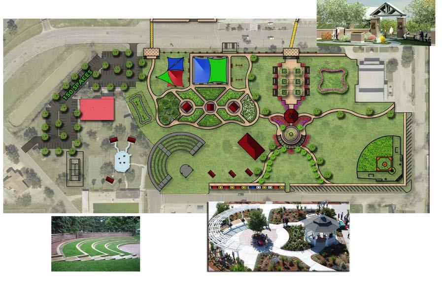
14 Priority Number 4
15 Priority 5: Allow and Encourage Mixed Use Development in the Core Areas of Harlingen Create a specific zoning category that allows and encourages mix use development. A new set of policies, guidelines and performance measures needs to be put in place that provide reasonable flexibility to development. Consider adopting a form based approach to development standards in the Core Areas of Harlingen.
16 Priority 6: Address Parking Needs in the Downtown District Based on a preliminary proposal for a downtown parking study received April 2016, the study would cost approximately $40,000.
17 Priority 6: Develop a formal Core Areas of Harlingen plan with individual subdistrict recommendations Downtown Master Plan Based on research into Downtown Master Plans developed for several Texas Main Street cities in recent years. Costs for this Plan have not yet been determined. Source; Texas Historical Commission

18 Priority 7
19 Priority Drainage Ditches Cost Pending 1 Dixieland Ditch $ 881, th Street Ditch $ 201, Rio Hondo Road Ditch $ 721, Lipscomb Ditch $ 493, Total $2,297,982.00


20 Priority 8 Acquire Fire training LPG Burn Prop Unit Grant submitted in 2016 for this project (awaiting grant approval ) The unit will help maintain firefighter proficiency and an ISO rating of (3) Cost: $332,000 $62,000 ( $32,000 =10 % project match & $30,000 infrastructure cost)

21 Fire Drill Tower Repairs Priority 8 A Fire Training Drill Tower is required to meet requirements set forth by: ISO and Texas Commission on Fire Protection Cost improvements estimated at $200,000

22 Renovation of City Hall Priority 9 Explore options for a new City Hall.
23 Priority 10: Fair Park & Victor Park All-Inclusive Playgrounds Estimated cost $2.5 million


24 Priority 11: Harlingen Arts & Heritage Museum Historical Building Phase I $41,750 Exhibit Design / Fabrication $23,250 Roof replacement $117,000 Phase II $318,000 Total $500,000 Demolition photos from the Museum s Historical Building
 Architect s")


25 Historical Building (cont d) Architect s rendering for Phase II renovations, Megamorphosis Exhibit Design, Meza Consultants

 Additional option is to install artificial turf on the Championship Fields.")
26 Priority Number 12: Soccer Complex Phase II Complete development of the Harlingen Soccer Complex Construct the second phase of the Harlingen Soccer Complex to include: upgrading the existing irrigation system to a two wire controlled system, enhance the soil condition of the existing fields, bring in select fill material for the new fields for optimal growing condition of Tift 419, construct two additional restrooms and new additional parking. ($2,100,000) Additional option is to install artificial turf on the Championship Fields. ($1,600,000)

27 Priority 13 - Spur 54 Convert from a 4 lane divided roadway to a 6 lane roadway with raised landscaped center islands and potentially bike lanes/paths, making it more attractive for development and providing greater quality of life to residents

28 Spur 54 Limits: From Chester Park Road to I-69E SB Frontage Road Project Description: Total Reconstruction and widening from 4 to 6 lanes Project Cost: $6,874,132 Project Funding: Proposition 1 and Proposition 7


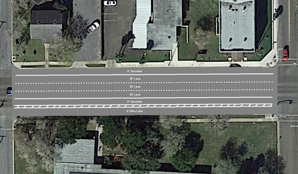
29 Priority 13 - Loop 499 Bike Lane Extension access, mostly by motor vehicle but increasingly by walking or bicycle, is the lifeblood of commerce and the economic life of Harlingen.
30 Loop 499 Bike Lane Extension Limits: From FM 507/Morgan/25th Street to SH 106/East Harrison Ave Project Length: 4.4 Miles Project Description: Extend existing bike lane, create an ordinance disallowing parking and creating a bike lane, striping bike lane symbols, and installing bike lane & No Parking signs Project Cost: $14,550 o (30 $300, 20 bike lane $225, 10 bike lane $105) Project Funding: City of Harlingen, Texas Department of Transportation

31 Priority 13 - Dixieland Turnaround Add a turnaround on the east side of Dixieland Road at I-2 to complement the turnaround on the west side of the road, further enhancing the road network in an area of focus for economic development
32 Dixieland Turnaround Limits: At Dixieland Road & Bass Pro Drive Project Description: Total reconstruction and add turnaround Project Cost: $1,500,000 Project Funding: Proposition 7

33 Priority 13 - FM 509 Extension Expand FM 509 north to connect to the proposed Outer Parkway (FM 1925) Project, an economically and regionally significant transportation corridor that will connect Edinburg to South Padre Island.

34 Priority 13 - FM 509 Extension
35 FM 509 Extension Limits: From FM 508 to New Location Outer Parkway Project Description: New Location - 2 lane rural roadway Project Cost: $3,620,000 Project Funding: Proposition 7, Cameron County

36 HSBMPO s Bicycle & Pedestrian Master Plan Will identify a network of on-street and off-street facilities to enable bicycle and pedestrian travel, an increasingly desired feature in many communities Will identify essential active transportation routes that will provide multimodal connections between study area communities Will prioritize routes in HSBMPO communities where enhanced facilities are necessary to connect residents to key destinations Plan/Study Cost: $79,682 Plan/Study Funding: MPO PL-112 Funds

37 Designate bike lanes along Tyler Ave. and Harrison Ave. from I-69 East Frontage Road to Loop $284,048
38
39
 Will increase quality of life")

40 Harlingen Multi-Modal Transit Center Would house transit from the public sector (such as Valley Metro) as well as from the private sector (such as VTC/Greyhound, Adame, etc ) Will increase quality of life by providing a central hub for all modes of transportation Currently in the HSBMPO s TIP Total project cost is $5,000,000 with a $1,000,000 local match Local match could be reduced to 5-10% through EDC status

41 Total Cost of all Priority Projects, Bike/Ped Plan, & City of Harlingen Bike Lanes: Priority 1 - Spur 54: $6,874,132 Priority 2 - Loop 499 Bike Lane Extension: $14,550 Priority 3 - Dixieland Turnaround: $1,500,000 Priority 4 - FM 509 Extension: $3,620,000 Priority 5 Harlingen Transit Center: $5,000,000 HSBMPO s Bicycle & Pedestrian Master Plan: $79, Proposed Bike Lanes by the City of Harlingen: $284,048 City of Harlingen Funding: $543,048 Outside Funding: $16,829, Total: $17,372, Highlighting denotes that the project is either fully or partially funded by outside sources


42 Priority 14: Valley International Airport - Aerotropolis Promote the development of the Aerotropolis concept as developed by the Airport Board. Identify funding sources and amounts and begin implementation of initial phases. Estimated cost. $100,000 annually. 42

43 Priority 15: Upgrade the Children s Library A well-designed environment is, of course, safe for infants and toddlers but, more than that, it supports their emotional well-being, stimulates their senses, and challenges their motor skills. * Our Current Children s Library: Current shelving offers little space for family seating areas. There is no interactive, or discovery component available. The space lacks color. *Landscape for Learning: The Impact of Classroom Design on Infants and Toddlers


44 Proposed Children s Library Create a bright, colorful space that is more attractive to children and is highly functional. Incorporate shelving that will allow for more family seating areas. Create a discovery wall and other interactive features. Estimated Capital Expenses: $94,000 Estimated Non-Capital Expenses: $96,000 Estimated Total Cost: $190,000


45 Priority 15: Upgrade the Library Computer Lab Our Current Computer Lab: The Harlingen Public Library currently offers 50 public computers. The computers are spread throughout the library. The demand for use of our computers is increasing. The location of the computers offer little privacy.

46 Proposed Computer Lab Create a cohesive computer lab. Construct the computer lab space by building a wall, door and installing new carpet. Update library infrastructure to support a larger computer lab. Purchase new furniture for the computer lab Estimated Capital Expenses: $84,000 Estimated Non-Capital Expenses: $175,000 Estimated Total Cost: $259,000

47 Priority 15: Create a Teen Library In November 2015, we started a Teen Advisory Group at the library. The group currently has 85 members and is still growing. The library has no dedicated space for teens to meet, have events or hang out.


48 Proposed Teen Room Estimated Capital Expenses: $54,000 Estimated Non-Capital Expenses: $50,000 Total Estimated Cost: $104,000 Create a fun, functional, inviting environment space for teens. Enclose the north corner on the first floor of the library with a glass wall. Create a dedicated computer lab for teens to work on homework and other research projects.

49 Priority Number 16: Hugh Ramsey Nature Education Center Improve Hugh Ramsey Nature Park as a major birding and wildlife attraction and develop a nature center facility. Build a 2300 square foot welcoming/education center, improve the trails, wetland ponds and bird blinds. Potential funding sources are Texas General Land Office, and Texas Parks and Wildlife The total estimated construction cost is approximately $1,200,000 dollars.

50 Priority Number 17: Trails: Ramsey to McKelvey. A 10 foot wide trail extension connecting McKelvey to Hugh Ramsey Park. This distance is 1 mile and will const $825,000. This section of trail is highlighted in lime green on the adjacent map.

51 Priority Number 17: 25 th Street Trail to the Downtown Area. Develop linear park/trail corridor along drainage corridors and new streets in West Harlingen Extend 25 th Street Hike and Bike Trail at three locations; first one using existing irrigation canal bank from Harrison St. to I69E for a total length of 3.2 miles. ($1,744,000 dollars) The second extension is to use existing Jefferson Street R.O.W to connect Business 77 to the Library for a total length of 0.60 miles. ($327,000 dollars) The third extension is to use Grimes R.O.W. connecting 25 th St. to Morgan Blvd for a total length of 0.60 miles. ($327,000 dollars) The total cost per mile is $545,000 for a total project cost $2.4 million dollars.
52 Funding Needed $26,608,300 Total Project Costs $63,220,519 Less Prop 1 & Prop 7 ($17,372,412) Less Convention Center ($14,846,825) {4b, HOT, TIFs 1,2,3} Legacy Foundation Grant-Parks ($425,000) Less Possible Drainage Grants ($2,297,982) Less Possible LPG Grant ($270,000) HAHM Donations ($500,000) Donations Playground ($400,000) Possible TPW Parks Grant ($500,000 Total Outside Funding ($36,612,219)
Executive Summary Route 30 Corridor Master Plan
 Route Corridor Master Plan Project Overview The Route Corridor Master Plan is a coordinated multimodal transportation and land use plan for the entire stretch of Route through East Whiteland Township,
Ann Arbor Downtown Street Plan
 1 Ann Arbor Downtown Street Plan Public Workshop #1 We know that. 2 Public right-of-way (streets, sidewalks, and alleys) make up 30% of the total District area of downtown. Streets need to provide mobility
Corpus Christi Metropolitan Transportation Plan Fiscal Year Introduction:
 Introduction: The Safe, Accountable, Flexible, Efficient Transportation Equity Act: A Legacy for Users (SAFETEA-LU) has continued the efforts started through the Intermodal Surface Transportation Efficiency
Exhibit 1 PLANNING COMMISSION AGENDA ITEM
 Exhibit 1 PLANNING COMMISSION AGENDA ITEM Project Name: Grand Junction Circulation Plan Grand Junction Complete Streets Policy Applicant: City of Grand Junction Representative: David Thornton Address:
Living Streets Policy
 Living Streets Policy Introduction Living streets balance the needs of motorists, bicyclists, pedestrians and transit riders in ways that promote safety and convenience, enhance community identity, create
Eastern PA Trail Summit October 1, 2018
 Eastern PA Trail Summit October 1, 2018 WHO WE ARE + WHY + WE RE * HERE * * * * * * Session Goals: Discuss how to coordinate planning and design in small, urbanized towns Consider how to develop alternative
CONNECTIVITY PLAN. Adopted December 5, 2017 City of Virginia Beach
 CONNECTIVITY PLAN Adopted December 5, 2017 City of Virginia Beach CONTENTS 1.0 Background & Purpose... 2 2.0 Existing Inventory & Analysis... 3 ViBe District Existing Walking Conditions... 4 3.0 ViBe District
DALLAS MIDTOWN REDEVELOPMENT PLAN FOCUS NORTH TEXAS Peer Chacko, AICP, Assistant Director, City of Dallas
 DALLAS MIDTOWN REDEVELOPMENT PLAN FOCUS NORTH TEXAS 2014 Peer Chacko, AICP, Assistant Director, City of Dallas Dallas Midtown: Strategic growth area Future transit node 2 Peterson Road Study Area Galleria
CITY OF BLOOMINGTON COMPLETE STREETS POLICY
 CITY OF BLOOMINGTON COMPLETE STREETS POLICY POLICY OBJECTIVE: The City of Bloomington will enhance safety, mobility, accessibility and convenience for transportation network users of all ages and abilities,
DES MOINES AREA MPO. Presentation to Iowa Commercial Real Estate Association. April 6, 2017
 DES MOINES AREA MPO Presentation to Iowa Commercial Real Estate Association April 6, 2017 Presentation Outline MPO Overview Trends We re Watching Plans, Projects, Initiatives, Regional Transportation Priorities
City of Birmingham Draft Multi-modal Transportation Plan
 City of Birmingham Draft Multi-modal Transportation Plan City Commission Public Hearing Monday, November 25, 2013 7:30 pm Norman Cox, PLA, ASLA The Greenway Collaborative, Inc. Ann Arbor, Michigan The
Bicycle Master Plan Goals, Strategies, and Policies
 Bicycle Master Plan Goals, Strategies, and Policies Mobilizing 5 This chapter outlines the overarching goals, action statements, and action items Long Beach will take in order to achieve its vision of
Corridor Vision Workshop Summary James Madison Elementary February 22,2018
 Corridor Vision Workshop Summary James Madison Elementary February 22,2018 WHY DEVELOP THIS STUDY? Ogden City is planning for better connectivity and access to jobs and housing. Working with area partners,
Route 7 Corridor Study
 Route 7 Corridor Study Executive Summary Study Area The following report analyzes a segment of the Virginia State Route 7 corridor. The corridor study area, spanning over 5 miles in length, is a multi
Environment and Public Works Committee Presentation
 Mixed Use Centers Complete Streets Guidelines Project Environment and Public Works Committee Presentation December 10, 2008 Project Objectives: Conduct an inter-departmental and agency process to study
Omaha s Complete Streets Policy
 Omaha s Complete Streets Policy (Adopted August 2015) VISION To create great places and enhance our quality of life, the City of Omaha will provide safe, accessible streets for all users. Complete Streets
City of Novi Non-Motorized Master Plan 2011 Executive Summary
 City of Novi Non-Motorized Master Plan 2011 Executive Summary Prepared by: February 28, 2011 Why Plan? Encouraging healthy, active lifestyles through pathway and sidewalk connectivity has been a focus
RESOLUTION NO ?? A RESOLUTION OF THE CITY OF NEPTUNE BEACH ADOPTING A COMPLETE STREETS POLICY
 RESOLUTION NO. 2018-?? A RESOLUTION OF THE CITY OF NEPTUNE BEACH ADOPTING A COMPLETE STREETS POLICY WHEREAS, safe, convenient, and accessible transportation for all users is a priority of the City of Neptune
Goal 3: Foster an environment of partnerships and collaboration to connect our communities and regions to one another.
 Non-Motorized Transportation Plan (NMTP) Draft Vision, Goal and,, Tri-County Regional Planning Commission (TCRPC) Purpose The purpose of the Tri-County Regional Planning Commission (TCRPC) Non-Motorized
Perryville TOD and Greenway Plan
 Perryville TOD and Greenway Plan Greenway Glossary Pathway: A bicycle and pedestrian path separated from motorized vehicular traffic by an open space, barrier or curb. Multi-use paths may be within the
Complete Streets. Designing Streets for Everyone. Sarnia
 Complete Streets Designing Streets for Everyone Sarnia Complete Streets ~ Sarnia ~ 2018 Introduction Our City is made up of a network of streets that we use to go for a walk, cycle to work, drive to the
WALKNBIKE DRAFT PLAN NASHVILLE, TENNESSEE EXECUTIVE SUMMARY NASHVILLE, TENNESSEE
 NASHVILLE, TENNESSEE EXECUTIVE SUMMARY Executive Summary A world-class multi-modal transportation system is essential to a vibrant city and better quality of life. -Mayor Barry The WalknBike plan aims
MASTER BICYCLE AND PEDESTRIAN PLAN
 VILLAGE OF NORTHBROOK MASTER BICYCLE AND PEDESTRIAN PLAN DRAFT PLAN OPEN HOUSE May 2, 2018 AGENDA 1. Community Engagement 2. Vision and Goals 3. General Structure of Plan 4. Recommendations Overview 5.
City of Charlottesville Bicycle and Pedestrian Master Plan Update
 City of Charlottesville Bicycle and Pedestrian Master Plan Update September 17, 2014 I. Welcome and meeting overview II. Project status update III. Network overview IV. Break-out groups Pedestrian Network
Chapter 7. Transportation. Transportation Road Network Plan Transit Cyclists Pedestrians Multi-Use and Equestrian Trails
 Chapter 7 Transportation Transportation Road Network Plan Transit Cyclists Pedestrians Multi-Use and Equestrian Trails 7.1 TRANSPORTATION BACKGROUND The District of Maple Ridge faces a number of unique
Bikeway action plan. Bicycle Friendly Community Workshop March 5, 2007 Rochester, MN
 Bikeway action plan Summary The was held on March 5, 2007 at the Rochester Mayo Civic Center. The workshop was hosted by Rochester-Olmsted County Planning Department in collaboration with the League of
Regional Transportation Needs Within Southeastern Wisconsin
 Regional Transportation Needs Within Southeastern Wisconsin #118274 May 24, 2006 1 Introduction The Southeastern Wisconsin Regional Planning Commission (SEWRPC) is the official areawide planning agency
including infrastructure, transit and open space, Open Space changed approximately 50 to approximately 60
 Draft North Branch Framework Plan s The below table itemizes changes made to the North Branch Industrial Corridor Framework and Design Guidelines. The original draft was posted March 17, 2017. This table
CHAPTER 7.0 IMPLEMENTATION
 CHAPTER 7.0 IMPLEMENTATION Achieving the vision of the Better Streets Plan will rely on the ability to effectively fund, build and maintain improvements, and to sustain improvements over time. CHAPTER
West Dimond Blvd Upgrade Jodhpur Street to Sand Lake Road
 West Dimond Blvd Jodhpur St to Sand Lake CSS Transportation Project Summary Municipality of Anchorage Project # 05 005 Project Manager: John Smith, P.E. (MOA PM&E) Project Administrator: Julie Makela,
integrated action plan
 public presentation. june 24, 2009. city of portsmouth, nh islington corridor integrated action plan richardson & associates, landscape architects evan haynes, public arts consultant Islington Street Corridor
Proposed. City of Grand Junction Complete Streets Policy. Exhibit 10
 Proposed City of Grand Junction Complete Streets Policy Exhibit 10 1 City of Grand Junction Complete Streets Policy Vision: The Complete Streets Vision is to develop a safe, efficient, and reliable travel
Transportation Master Plan Advisory Task Force
 Transportation Master Plan Advisory Task Force Network Alternatives & Phasing Strategy February 2016 BACKGROUND Table of Contents BACKGROUND Purpose & Introduction 2 Linking the TMP to Key Council Approved
CITY OF COCOA BEACH 2025 COMPREHENSIVE PLAN. Section VIII Mobility Element Goals, Objectives, and Policies
 CITY OF COCOA BEACH 2025 COMPREHENSIVE PLAN Section VIII Mobility Element Goals, Objectives, and Policies Adopted August 6, 2015 by Ordinance No. 1591 VIII MOBILITY ELEMENT Table of Contents Page Number
Bicycle and Pedestrian Chapter TPP Update Overview. TAB September 20, 2017
 Bicycle and Pedestrian Chapter TPP Update Overview TAB September 20, 2017 Bicycling & Walking in the Twin Cities Where are we now? The Bike-Pedestrian system Current trends New developments Where are we
This page intentionally left blank.
 This page intentionally left blank. COMMUNITY Coweta Community Overview Coweta Coweta, a residential community located in Wagoner County, is a suburb of Tulsa situated southeast of the metropolitan area
HARRISON STREET/OAKLAND AVENUE COMMUNITY TRANSPORTATION PLAN
 HARRISON STREET/OAKLAND AVENUE Community Workshop #4: Draft Plan Review December 3, 2009 D E S I G N, C O M M U N I T Y & E N V I R O N M E N T INTRODUCTIONS Key Project Staff: Alisa Shen, Project Manager,
Making Phoenix Streets Complete. City of Phoenix Complete Streets Initiative
 Making Phoenix Streets Complete City of Phoenix Complete Streets Initiative City of Phoenix Planning Commission March 2014 Presentation Outline What are Complete Streets? Benefits of Complete Streets Complete
University of Victoria Campus Cycling Plan Terms of Reference. 1.0 Project Description
 University of Victoria Campus Cycling Plan Terms of Reference 1.0 Project Description The Campus Cycling Plan, a first for the University, will provide a comprehensive and coordinated approach to support
CITY OF PORTSMOUTH PLANNING DEPARTMENT
 CITY OF PORTSMOUTH PLANNING DEPARTMENT MEMORANDUM TO: JOHN P. BOHENKO, CITY MANAGER FROM: JULIET T.H. WALKER, PLANNING DIRECTOR SUBJECT: BICYCLE / PEDESTRIAN PLAN PROGRESS UPDATE DATE: 3/13/2018 Background
Project Update May 2018
 Project Update May 2018 Dakota County, in cooperation with the City of Lakeville, is planning to reconstruct 202 nd Street West (County Road 50) from Holyoke Avenue to Cedar Avenue (County Road 23). 202
2045 Long Range Transportation Plan. Summary of Draft
 2045 Long Range Transportation Plan Summary of Draft Fredericksburg Area Metropolitan Planning Organization The George Washington Region includes the City of Fredericksburg and the counties of Caroline,
Table #6 VISION CHARACTERISTICS
 Table #6 VISION White Flint is a place to live, work, play, shop, and walk with sufficient density to encourage quality redevelopment. Vibrant streets and consistent streetscapes are important. CHARACTERISTICS
Chapter 5 Future Transportation
 Chapter 5 Future Transportation The Future Land Use Plan identifies the desired land use designations. The land uses desired for Crozet depend, in large part, on the success of the transportation system,
A CHANGING CITY. of Edmonton, it is essential that it reflects the long-term vision of the City.
 A CHANGING CITY By the year 2040, Edmonton will be home to more than 1 million people. To accommodate growth and support a healthy and compact city, we need a new approach to development/redevelopment
COMPLETE STREETS POLICY Exhibit A to Ordinance
 CITY OF WENATCHEE COMPLETE STREETS POLICY Exhibit A to Ordinance 2016-24 Prepared and Reviewed By: City of Wenatchee Community & Economic Development Department City of Wenatchee Public Works Department
7 Complete Streets & Roadway Aesthetics
 7 Complete Streets & Roadway Aesthetics 7.1 OVERVIEW Our streets lay the foundation for how we interface with travel needs, physical exercise, social exchanges and access to goods and services. They are
Section 5: Bike and Pedestrian
 Section 5: Bike and Pedestrian Existing Conditions: One defining feature of Glynn County appreciated by both residents and visitors is the extensive sidewalk and bike path system. The City of Brunswick,
May 12, 2016 Metro Potential Ballot Measure Issue Brief: Local Return
 Summary: Local return is an important revenue source for cities to maintain their local transportation infrastructure. Most cities use their local return to operate small bus systems and repave streets,
12 RECOMMENDATIONS Road Improvements. Short Term (generally the next five years)
") 12 RECOMMENDATIONS Recommendations are based on the technical analysis of existing and future road and active transportation conditions, the results of the review of existing City policies and public feedback.
12 RECOMMENDATIONS Recommendations are based on the technical analysis of existing and future road and active transportation conditions, the results of the review of existing City policies and public feedback.
SR-203 Sidewalks and Town-Wide Mobility Improvements. Town Council Presentation September 7, 2016
 SR-203 Sidewalks and Town-Wide Mobility Improvements Town Council Presentation September 7, 2016 SR-203 Sidewalks and Town- Wide Mobility Improvements SR-203 Sidewalks and Appurtenances Town-Wide Mobility
Bicycle and Pedestrian Plans and Improvements
 Bicycle and Pedestrian Plans and Improvements Presented to the City Council By Randle Harwood, Planning and Development, and Richard Zavala, Parks and Community Services September 24, 2013 Purpose Review
5. Pedestrian System. Accomplishments Over the Past Five Years
 5. Pedestrian System Accomplishments Over the Past Five Years The Alamo Area Metropolitan Planning Organization (MPO) and its partner agencies recognize the importance of improving pedestrian mobility.
 Time of Change We Are Growing We Are An Attractive Place To Live We Are Age Diverse + Living Longer 50000 40000 30000 20000 10000 0 2010 Census Job Density Housing Sheds Transit Sheds The Project FUNDING
Lee s Summit Road Improvement Study Public Open House June 7, 2007 Summary of Comment Card Responses
 Lee s Summit Road Improvement Study Public Open House June 7, 2007 Summary of Comment Card Responses Introduction At the Lee s Summit Road Improvement Study Public Open House held Thursday, June 7, 2007
Bus Rapid Transit Plans
 Twin Cities Region Bus Rapid Transit Plans ULI Minnesota Workshop Connecting Bus Rapid Transit to the Community December 15, 2009 John Levin Director of Service Development Metro Transit Metropolitan Area
TOWN OF PORTLAND, CONNECTICUT COMPLETE STREETS POLICY
 TOWN OF PORTLAND, CONNECTICUT COMPLETE STREETS POLICY I. VISION, GOALS & PRINCIPLES VISION To improve the streets of Portland making them safer and more accessible for all users including pedestrians,
AMATS Complete Streets Policy
 AMATS Complete Streets Policy Table of Contents: Section 1. Definition of Complete Streets Section 2. Principles of Complete Streets Section 3. Complete Streets Policy Section 4. Consistency Section 5.
TRANSPORTATION NEEDS ASSESSMENT
 TRANSPORTATION NEEDS ASSESSMENT A travel demand analysis was carried out to determine the operational issues and the potential benefit that adding traffic capacity would have on the road network. All the
NM-POLICY 1: Improve service levels, participation, and options for non-motorized transportation modes throughout the County.
 Transportation PRINCE WILLIAM COUNTY 2008 COMPREHENSIVE PLAN NON-MOTORIZED PLAN CONTENTS Goals, Policies, and Action Strategies Table 4 (Bike Facility Classifications and Descriptions) Table 5 (Bike Facility
APPENDIX D: Southwest Volusia Regional Transportation Study. Evaluation Criteria FINAL
 D: PROJECT PRIORITIZATION Prioritization of the improvements proposed in the Multimodal Improvement Plan is required in order to determine which projects should be funded first, where the transportation
MTP BICYCLE ELEMENT UPDATE. November 2017
 MTP BICYCLE ELEMENT UPDATE November 2017 TIME FOR AN UPDATE Bicycle Element adopted in July 2008 Almost 10 years old Many planned facilities have been implemented 10 years more experience in planning,
Vision: Traditional hamlet with an attractive business/pedestrian friendly main street connected to adjacent walkable neighborhoods
 N D. Focus Area II Vision: Traditional hamlet with an attractive business/pedestrian friendly main street connected to adjacent walkable neighborhoods Transit Road Focus Area II is located in the Hamlet
APPENDIX A: Complete Streets Checklist DRAFT NOVEMBER 2016
 APPENDIX A: Complete Streets Checklist DRAFT NOVEMBER 2016 Complete Streets Checklist MetroPlan Orlando s Complete Streets Checklist is an internal planning tool for staff to further implementation of
Table of Contents Introduction. 2 Purpose of the Plan...2 The Benefits of Walking and Bicycling...3 Vision and Goals of the Plan...
 BICYCLE AND This plan was created through a grant from the Healthy Communities Program with the cooperation of the City of Cynthiana, Cynthiana Main Street, Cynthiana-Harrison County-Berry Joint Planning
Broward Boulevard Gateway Implementation Project, Downtown Walkability Analysis, & Joint Development Initiative (JDI)
") Broward Boulevard Gateway Implementation Project, Downtown Walkability Analysis, & Joint Development Initiative (JDI) City of Fort Lauderdale ~ Commission Conference July 10, 2012 Page 1 of 15 A Multi-Agency
Broward Boulevard Gateway Implementation Project, Downtown Walkability Analysis, & Joint Development Initiative (JDI) City of Fort Lauderdale ~ Commission Conference July 10, 2012 Page 1 of 15 A Multi-Agency
Mainstreet Master Plan Land Use
 Mainstreet Master Plan 04 Land Use Top Recommendations Active Uses: Promote active ground-floor uses such as retail, restaurants, galleries and personal services with interactive storefronts for Mainstreet
Linking Transportation and Health in Nashville & Middle Tennessee
 Linking Transportation and Health in Nashville & Middle Tennessee Fit Nation New Orleans CPPW Mentoring Grant Built Environment Program May 14, 2011 Local Transportation Planning Framework Federal U.S.
WELCOME TO OPEN HOUSE # 1 June 14, 2017
 Langstaff Road Weston Road to Highway 7 Class Environmental Assessment Study WELCOME TO OPEN HOUSE # 1 June 14, 2017 Please sign in and join our mailing list Purpose of Open House #1 & Study Area York
A Complete Streets Policy for Saratoga Springs. Presented By: Shared Access Saratoga
 A Complete Streets Policy for Saratoga Springs Presented By: Shared Access Saratoga April 17, 2012 Agenda 1. Introduction to Complete Streets (CS) 2. Shared Access Saratoga 3. Why is CS Important 4. What
Kelowna On the Move. Pedestrian and Bicycle Master Plan
 Kelowna On the Move Pedestrian and Bicycle Master Plan Executive Summary April 2016 Purpose of the Plan The Pedestrian and Bicycle Master Plan identifies infrastructure, planning, and policy requirements
Ulster County Non-motorized Transportation Plan
 Ulster County Non-motorized Transportation Plan NTAC Meeting NOTES Ulster County Community College Date 08.29.07 Time: 1:00 p.m. - 3:00 p.m. Agenda Welcome /Intro Project Status Report o Project is on
COUNCIL POLICY NAME: COUNCIL REFERENCE: 06/119 06/377 09/1C 10llC 12/1C INDEX REFERENCE: POLICY BACKGROUND
 COUNCIL POLICY NAME: COUNCIL ADVISORY COMMITTEES - TERMS OF REFERENCE ISSUED: APRIL 3, 2006 AMENDED: NOVEMBER 27, 2006 NOVEMBER 23, 2009 JANUARY 11, 2010 DECEMBER 17, 2012 POLICY COUNCIL REFERENCE: 06/119
Building Great Neighbourhoods QUEEN ALEXANDRA
 Building Great Neighbourhoods QUEEN ALEXANDRA We are here today to Explain how the City is investing in improving your neighbourhood and how your neighbourhood will be improved to meet current City standards.
Hennepin County Bicycle and Pedestrian Planning
 Hennepin County Bicycle and Pedestrian Planning 1 Value of bicycle and sidewalk systems Safety Livability Mobility Health Personal Finances Economic Sustainability Clean Air Recreation Parking and congestion
Bicycle Lanes Planning, Design, Funding South Mountain Partnership Trails Workshop Roy Gothie PennDOT Statewide Bicycle Pedestrian Coordinator
 Bicycle Lanes Planning, Design, Funding 2018 South Mountain Partnership Trails Workshop Roy Gothie PennDOT Statewide Bicycle Pedestrian Coordinator Policy Changes: BOP Bicycle Policy Changes The OLD Way
COASTAL RAIL TRAIL ROSE CREEK BIKEWAY PROJECT COMMUNITY WORKSHOP #2 AUGUST 15, 2013
 COASTAL RAIL TRAIL ROSE CREEK BIKEWAY PROJECT COMMUNITY WORKSHOP #2 AUGUST 15, 2013 CHRIS CARTERETTE, AICP PROJECT MANAGER Chris.Carterette@sandag.org Direct: 619-699.7319 REGIONAL PLANNING BACKGROUND
JOINT PARTNERSHIPS: Working Together To Support Light Rail in Santa Monica
 JOINT PARTNERSHIPS: Working Together To Support Light Rail in Santa Monica ITY OF ANTA MONICA RAIL-VOLUTION / OCTOBER 17, 2012 SARAH LEJEUNE, PRINCIPAL PLANNER, STRATEGIC + TRANSPORTATION PLANNING DIVISION
Section 9. Implementation
 Section 9. Implementation The transportation system is just one of many aspects that must be carefully planned to maintain and enhance the quality of living in Cecil County. The Cecil County Bicycle Plan
UNIVERSITY AVENUE CORRIDOR REDESIGN. January 8, 2017 PUBLIC OPEN HOUSE
 January 8, 2017 PUBLIC OPEN HOUSE COLLABORATIVE COMMUNITY-BASED DESIGN IS THE FOUNDATION TO A SUCCESSFUL PROJECT AGENDA FOR TONIGHT 1 INTRODUCTIONS 2 WHY ARE WE HERE PROJECT NEED 3 SCHEDULE & GOALS 4 OPEN
EXECUTIVE SUMMARY. Vision
 Vision Walking and bicycling in Salt Lake City will be safe, convenient, comfortable, and viable transportation options that connect people to places, foster recreational and economic development opportunities,
Rochester Downtown Bicycle Study 2009
 Rochester Downtown Bicycle Study 2009 Relationship of ROCOG Long Range Transportation Plan to Rochester Comprehensive Plan Regional Long Range Transportation Plan (LRTP) is prepared under the auspices
Goodlettsville Bicycle and Pedestrian Plan Executive Summary
 Goodlettsville Bicycle and Pedestrian Plan July 2010 In Cooperation with the Nashville Area Metropolitan Planning Executive Organization Summary Introduction Progressive and forward thinking communities
NJDOT Complete Streets Checklist
 Background The New Jersey Department of Transportation s Complete Streets Policy promotes a comprehensive, integrated, connected multi-modal network by providing connections to bicycling and walking trip
MERRIMACK TOWN CENTER PEDESTRIAN AND TRAIL MASTER PLAN
 MERRIMACK TOWN CENTER PEDESTRIAN AND TRAIL MASTER PLAN NOVEMBER 12, 2009 PREPARED BY: NASHUA REGIONAL PLANNING COMMISSION Cover art designed at www.wordle.net/create. This design is based upon the words
Solana Beach Comprehensive Active Transportation Strategy (CATS)
") Solana Beach Comprehensive Active Transportation Strategy (CATS) 3.0 Goals & Policies The Solana Beach CATS goals and objectives outlined below were largely drawn from the Solana Beach Circulation Element
Solana Beach Comprehensive Active Transportation Strategy (CATS) 3.0 Goals & Policies The Solana Beach CATS goals and objectives outlined below were largely drawn from the Solana Beach Circulation Element
This page intentionally left blank.
 This page intentionally left blank. COMMUNITY Glenpool Community Overview Glenpool Glenpool is a city of nearly 12,000 residents located in Tulsa County southwest of Tulsa and Jenks. The city is growing
MAG Town of Cave Creek Bike Study Task 6 Executive Summary and Regional Significance Report
 Page 1 MAG Town of Cave Creek Bike Study Task 6 Executive Summary and Regional Significance Report August 1, 2012 MAG Project #481 Page 2 Task 6 Executive Summary and Regional Significance Report Introduction
APPENDIX G: INTERSECTION NEEDS AT OKEECHOBEE BOULEVARD
 APPENDIX G: INTERSECTION NEEDS AT OKEECHOBEE BOULEVARD INTERSECTION NEEDS AT SR 7 and OKEECHOBEE BOULEVARD SR 7 Extension Project Development and Environment (PD&E) Study From Okeechobee Boulevard (SR
2040 RTP. Chapter 6: Investments in our Transportation Future
 2040 RTP Chapter 6: Investments in our Transportation Future This chapter describes the transportation investments proposed for the San Benito region that support the goals and objectives of the Regional
NOTICE OF AVAILABILITY/NOTICE OF COMMENT PERIOD OF A DRAFT EIR/EIS/EIS FOR PUBLIC REVIEW AND HEARINGS
 Tahoe Transportation District 128 Market Street, Suite 3F Stateline, NV 89449 Phone: (775) 589-5500 www.tahoetransportation.org Federal Highway Administration 650 Capitol Mall, Suite 4-100 Sacramento,
Plant City Bicycle and Pedestrian Master Plan. Project Update March 2, 2017
 Plant City Bicycle and Pedestrian Master Plan Project Update March 2, 2017 NOV Project Kickoff DEC/ JAN FEB/ MAR Plan Review/Field Work Public Meeting/Coordination Meetings Develop Draft Plan APR/ MAY
City of Waterloo Complete Streets Policy
 City of Waterloo Complete Streets Policy Chris Hodgson P. Eng City of Waterloo Complete Streets Forum 2011 April 28-29 Toronto Waterloo context: Current population Major employers Universities and student
ACTIVE TRANSPORTATION/NONMOTORIZED TRANSPORTATION
 ACTIVE TRANSPORTATION/NONMOTORIZED TRANSPORTATION BACKGROUND Active transportation, also known as nonmotorized transportation, is increasingly recognized as an important consideration when planning and
NEWMARKET UPHAM S CORNER
 SOUTH STATION Planning Initiative NEWMARKET UPHAM S CORNER COLUMBIA ROAD (P) FOUR CORNERS/GENEVA Working Advisory Group (WAG) Meeting #5 TALBOT AVENUE MORTON STREET BLUE HILL AVE/CUMMINS HWY (P) RIVER
4. Mobility and Transportation Element. Page Bikes and Pedestrians
 Below are the specific General Plan text changes proposed for A-16-015 and the proposed changes to Figure MT-2 Paths and Trails. In general changes consist of removing references to the Bicycle, Pedestrian
Westgate/Belvedere Homes Community Redevelopment Agency. Belvedere Heights. Streetlights & Sidewalks Improvements Project.
 Westgate/Belvedere Homes Community Redevelopment Agency Belvedere Heights Streetlights & Sidewalks Improvements Project Phase II TPA 2018 Transportation Alternatives Program (TAP) BTPAC Presentation Thursday,
Uptown Wayfinding Signage Project
 Uptown Wayfinding Signage Project REFINED SIGNAGE DESIGN November 2014 Project Goals and Objectives Connect public spaces showcasing Oakland s diverse neighborhoods and unique character Develop Vehicular
5.0 Roadway System Plan
 Southwest Boise Transportation Study Page 16 5.0 Roadway System Plan The Roadway System Plan outlines roadway improvements in the Initial Study Area. It forecasts future deficiencies on the arterial system,
1.0 EXECUTIVE SUMMARY
 1.0 EXECUTIVE SUMMARY The Active Transportation Plan is a guide to accomplish the Town s vision for developing a network of sidewalks, on-road bicycle facilities, and trails that allow for safe and convenient