The implementation of a 2+1 road scheme in Ireland: a case for Australia?
|
|
|
- Stuart Bishop
- 6 years ago
- Views:
Transcription
1 The implementation of a 2+1 road scheme in Ireland: a case for Australia?, E. 1 1 M Eng; MICE; CEng Parsons Brinckerhoff, Australia egazzini@pb.com.au Abstract This paper describes the implementation of the first greenfield 2+1 road scheme in Ireland, which opened to traffic in late 2007 as part of the pilot program launched in 2002 to implement 2+1 roads throughout Ireland. A 2+1 road is a three lane road with a median barrier between the opposing directions. The direction of flow with two lanes alternates along the route to allow defined sections of overtaking. The median barrier prevents imprudent overtaking manoeuvres into oncoming traffic, which has significant proven safety benefits at lower costs than divided carriageway construction. The policy has evolved to 2+2 type roads in Ireland, which provides additional capacity and safety benefits over single carriageway roads. Ireland s National Development Plan (Irelands 10 year infrastructure plan), proposed that 850 kilometres of the National Primary road network would be upgraded to a 2+1 road type if the pilot was successful, equating to approximately 30% of the National Primary road network. Ireland has a large rural road network, which accounts for a significant proportion of fatalities and serious injuries, with low traffic volumes that do not justify dual carriageway construction. Some of the perceived common difficulties and drawbacks of implementing a 2+1 road system that have been found in both Ireland and Sweden (which also uses this system) are: increased crashes into the barrier and resultant high maintenance costs accommodating emergency vehicles, breakdowns and maintenance works restricted access for property owners public perception motorcyclists. This paper looks at how the concept of a 2+1 road might fit into the National Road Strategy for Australia as a possible solution to rural road deaths. The paper summarises some key research undertaken to date in Victoria on the use of flexible barriers and provides an example of a scheme that has recently been opened on the Pacific Highway in NSW, which has one of the worst records for fatal head-on collisions in Australia. Keywords 2+1 road, fatal crashes, head on collisions, flexible barriers 554
2 Introduction Ireland has a population of 4.2 million (2003) and a road network of 91,000 kilometres of local and regional roads, and 5,415 kilometres of National road network, which represents 6% of the total road network. Of the National road network, 4,860 kilometres is two lane undivided carriageway, with 308 kilometres of dual carriageway or 2+1 roads, and 247 kilometres of motorway. In 1996, Ireland had a crash rate of 12.6 fatalities per 100,000 population, which dropped to 9.6 by 2005 after the introduction of, among other things, a demerit point system for driving offenses on driving licenses and maximum blood alcohol levels limits when driving. By 2005 Ireland had experienced a 35.7% drop in numbers of accidents and a 12% drop in fatalities. From 1998 to 2003 the improvement in Ireland s road accident statistics was among the best in Europe, improving from 112 to 84 deaths per million population. However, from 2003 to 2006, Ireland was one of the few countries in Europe to show a deteriorating trend, with road fatalities increasing from 84 to 87 per million population. In 2006 Ireland returned to the 2003 level, and this improving trend has continued into 2007 (RSA, 2007). In 2007 Ireland ranked ninth out of the 25 European Union (EU) countries in Europe, up from 16 in The road toll of 338 in 2007 represented a reduction of 8% on 2006 figures, the second lowest figure since records began. The EU target is to reduce road accidents by 50% by 2010 from a base year of 2000, which equates to 252 deaths per year for Ireland by This target is adopted under the current road safety strategy for Ireland. The 2007 to 2012 Road Safety Strategy for Ireland marked a change in focus to prioritise prevention of collision in addition to planning to contain the consequences and recovery/rehabilitation of the injured. The change in focus was for policy to accept that road users will make mistakes and to seek to compensate for those mistakes by designing and building a more forgiving road network. In 1996, Ireland embarked on an ambitious infrastructure program (National Development Plan) that included the replacement and upgrade of two thirds of the National Primary road network, which had been neglected over many decades, to divided carriageways. At the time, Ireland was experiencing unprecedented economic growth (dubbed the Celtic Tiger) and was often named a first world country with third world infrastructure. Over the life of the current road safety strategy, the National Development Plan will spend 1.25 billion per year on new infrastructure and 20 million annually on road safety measures. The current road safety action plan includes a raft of educational, enforcement and legislative measures (RSA, 2007). Some of the key engineering measures include: Putting in place remedial schemes at identified collision locations on non-national roads 180 schemes per annum. Implementing 80 road safety remedial schemes per annum and eliminating backlogs by Continuing to monitor and develop road types, for example divided roads, ensuring best safety standards are incorporated into road design. Analysing six National Secondary routes per annum and applying a remedial measures program based on the findings. Reviewing and developing new design standards for National Secondary roads. Developing design guidelines for forgiving road sides. In Ireland, head on collisions account for 20% of accidents on two lane roads, and 37% of fatal accidents. Single vehicle accidents account for 24% of accidents on two lane roads and 30% of fatal accidents (NRA, 2004). 555
 proposed that 1,200 kilometres of this network would be upgraded to Freeway standard, and approximately half of")

3 The National Primary road network is 2,800 kilometres and carries 31% of total traffic. In 2002, as part of the National Development Plan the National Roads Authority (NRA) proposed that 1,200 kilometres of this network would be upgraded to Freeway standard, and approximately half of the remaining road network 850-kilometres would be upgraded to a 2+1 road type approximately 30% of the National Primary network. In 2002, a pilot program was introduced to evaluate the performance of the 2+1 road type. The intention of the pilot was to test the safety benefits and cost effectiveness of these types of roads, with the intention to replace the wide-spread use of the wide single carriageways in Ireland as a safer alternative. The pilot program included two retrofit 2+1 schemes totalling 15 kilometres, two greenfield 2+1 schemes totalling 19 kilometres, and one 9 kilometre 2+2 scheme also greenfield. The first greenfield scheme identified was the N2 Clontibret to Castleblayney road realignment scheme. This 16 kilometre rural single carriageway road realignment had been through the planning process and had a land corridor and preliminary design approved as an upgrade to the existing two lane carriageway road. This road realignment scheme had been designed as a wide single carriageway road (WS2). The NRA in Ireland considered that these types of roads would significantly reduce fatal head-on collisions on single carriageway roads and reduce severity of all accidents by eliminating imprudent overtaking (NRA, 2004). The N2 road realignment scheme a wide single carriageway A wide single carriageway had 5 metre wide lanes and 2.5 metre hard shoulders on each side, a total pavement width of 15 metres. The capacity for a standard single carriageway (no hard shoulders) is 11,600 Annual Average Daily Traffic (AADT) for a level of service D this can be increased to 13,800 AADT for a wide single carriageway that allows for limited overtaking of slower vehicles using the hard shoulders (see Figure 1). Figure 1 Wide single carriageway design in Ireland 556
4 Figure 2 Cross-section for a 2+1 road in Ireland A preliminary design had been completed for the planning stage of the original scheme and planning laws in Ireland dictated that the local council had to approve any changes to the scheme, provided that the scheme retained its original overall form and function and did not make the environmental impacts any worse. The road corridor was fixed by the previous planning work. The design team redesigned the scheme from a wide single carriageway alignment to a 2+1 road (refer Figure 2), and at the same time assisted the NRA with developing standard details for an interim design guide for the industry, and getting the revised scheme on display and approved by the local council, who in Ireland act as the road authority. With the road corridor fixed and the introduction of a median barrier into the scheme, the horizontal and vertical alignment could be redesigned as the requirement for forward visibility, widened verges and to provide safe overtaking opportunities was no longer required. This reduced the footprint of the scheme within the road corridor by reducing the widened verge requirements, and hence the cut and fills in the alignment. The savings in earthworks enabled the introduction of service roads in some places in the road corridor. The number, and to some degree the form, of junctions were largely fixed by the previous planning work. There were at-grade junctions that maintained the connectivity of the local road network through priority junctions. There was one priority T intersection, two staggered T intersection, one roundabout, and two compact grade-separated junctions along the scheme, and one fully grade-separated junction. The previous scheme also facilitated a number of landowners with direct paddock access onto the proposed road realignment. Under a wide single carriageway design, these farm vehicles would normally travel along the hard shoulders. This was common practice for single carriageways in Ireland up until this time. In addition the wide hard shoulder is typically used for pedestrian and cyclist activity. 557
5 What is a 2+1 road? The 2+1 road type is intended for rural situations where junctions and accesses are infrequent. The implementation of short isolated lengths of 2+1 road is not recommended, preferable lengths of these road types is 5 to 10 kilometres, and they should start and end with a junction to reduce road user confusion. A 2+1 road involves the introduction of a continuous overtaking lane to a single carriageway crosssection and a median with a central barrier; this reduces crash severity whilst providing improved traffic operations within a restricted road reserve. The third lane alternates each side and is separated from opposing traffic by a 2.0 metre paved median containing a wire rope barrier. The cross section is kept economic by hard strips on each side of 1.0 metre width. Using 3.5 metre lanes the total pavement width for a 2+1 road is 14.0 metres; a reduction of 1 metre in pavement width over the wide single carriageway cross-section. The implementation of a 2+1 road type also provides a higher capacity road than a wide single carriageway. The introduction of the climbing lane effectively increases the capacity provided by the road realignment to 17,250 AADT for a 2+1 road, (NRA, 2006). This road type fills the gap between a single carriageway and carriageway in terms of traffic flow. a dual The rules for introducing the third lane follow the guidelines for climbing lanes and as well as allocating an equal amount of overtaking opportunity for each direction, must be present on significant grades and each two lane section should ideally be between 1 and 2 kilometres. Too long a length of overtaking and the single lane section road users can suffer frustration and too short a length and there is not enough passing opportunity to achieve the capacity targets. Szagal (2005) used a simulation model to analyse the effects of different additional lane lengths on traffic performance found that any length from 950 metres to 1,500 metres performed equally well. The location of the changeover between each section of 2+1 is considered as part of the overtaking lane layout and usually occurs at junctions. Where distances between junctions require a changeover between the junctions, then either a critical changeover (lane drop) or a non-critical changeover (lane gain) is used. In both cases, the outer lane merges into the inner lane in accordance with current European overtaking conventions. Changeover lengths vary from 50 to 300 metres and depend upon the taper length of the lane 558
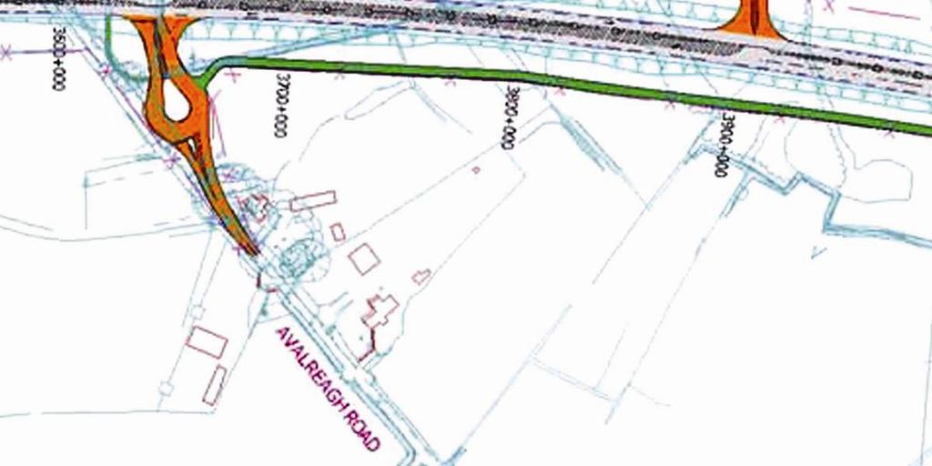
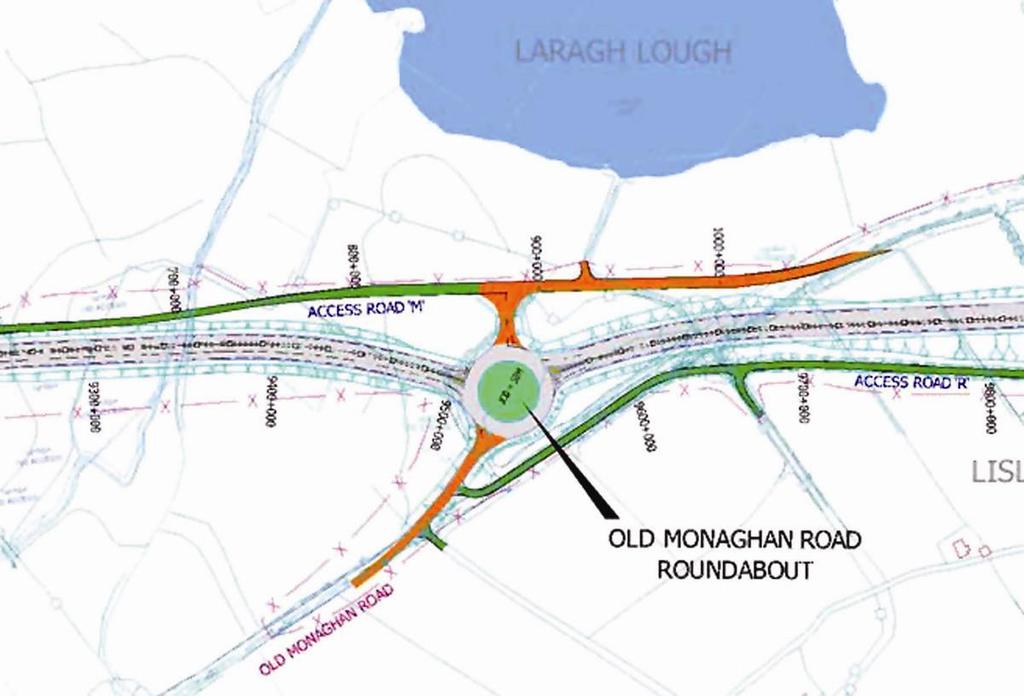
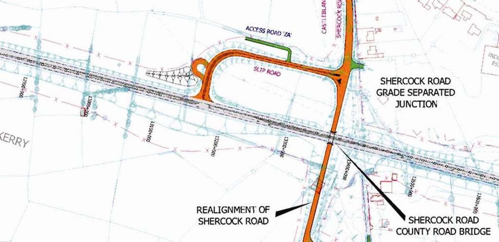
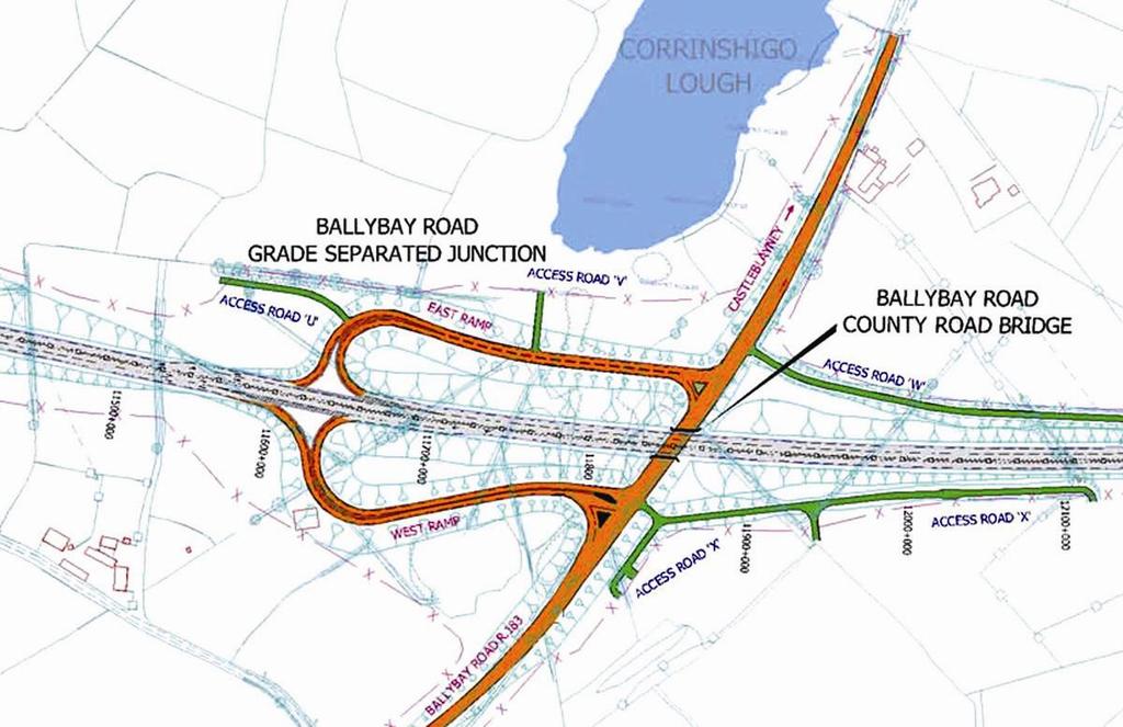
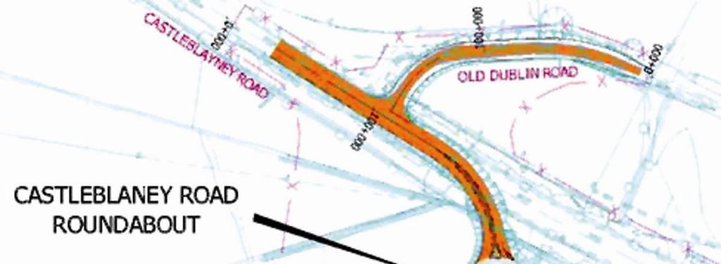
6 drops and gains that are required, and are used to reduce the cross-section to 1+1 prior to junctions. Typical layouts of changeovers are shown in Figure 3. Figure 3 Layover of changeover critical and non-critical Implementing a 2+1 road design An optimisation exercise was carried out to balance junction locations, overtaking sections and uphill gradients. Table 1 shows a breakdown of the arrangement of overtaking sections between intersections. Table 1 Summary of overtaking lengths on N2 scheme Section of road Glennyhorn T intersection - Ballybay roundabout Ballybay roundabout - Avalreagh staggered T intersection Southbound (km) 1.6 Avalreagh staggered T intersection - Old 0.9 Monaghan Road roundabout 1.8 Old Monaghan Road roundabout - Ballybay Road grade-separated interchange 0.8 Ballybay road grade-separated interchange - Shercock Road grade-separated junction Northbound (km) Shercock Road grade-separated junction Castleblayney Road roundabout 0.9 Total overtaking length Percent of total scheme length (16 km) 37% 36% 559
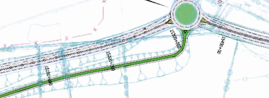
7 A measure of success was the length of carriageway in each direction that provides overtaking opportunities as a percentage of the project length. The scheme achieved a ratio of 36% overtaking distance in each direction as a proportion of the 16 kilometre scheme length. A total of 73% of the scheme has three lanes, the remainder being lost in junctions and critical and non critical changeovers. Ireland is typically made up of small holdings, historically these were interlinked with rights of way and access roads. Depending on whether the scheme is greenfield or an existing alignment, issues for landowners include: existing and proposed accesses minimising severance provision of underbridges and cattle crossings, or investigate alternative routes or buy out remaining land lots. Accessing the new road U-turn provision and length of detours Access onto a 2+1 road is restricted for landowners to left in and left out. With the landowner having to carry out a detour to achieve a right turn movement. To minimise the number of these accesses service roads were introduced to collect accesses either onto the next minor road or into one access onto the main road. The use of the single lane sections by slow moving farm vehicles is an issue for this type of road and was minimised as far as possible for this scheme. In all, access roads were provided for landowners totalling 4.2 kilometres, which restricted the number of left in, left out accesses to four for the whole scheme. The access roads generally collected property accesses together and feeds them onto the local road system or the adjacent junction where they could access the 2+1 scheme. U turn provisions were ideally provided at junction locations and one of the easiest ways of providing for U-turns is provision of a roundabout. The introduction of a roundabout in the middle of rural Ireland on a main road was unconventional at the time, but was approved as a necessary, and the best available solution. The introduction of U-turn facilities at junctions produced some quite complex signing schemes for road users. A typical U turn arrangement for a minor road is shown in Figure 4. Figure junction layout 560


8 In addition, the conversion allowed the introduction of two additional livestock underpasses, and a pedestrian-cycle underpass. Separate pedestrian/cycle facilities were provided on a one kilometre section adjacent to the road. The introduction to the scheme at each end was preceded by a lead in length of 600 metre of wide hatched median with no barrier. As part of the optimisation exercise the junction types were reviewed and two at grade roundabouts were introduced into the scheme. The final scheme had three at grade roundabouts, one staggered intersection and a graded-separated intersection with right turn in movement and one fully grade separated intersection with no right turn movements allowed. The layouts of these intersections is shown in Figure 5. Figure 6 N2 Clontibret to Castleblayney Scheme 2+1 arrangement 561
9 When the scheme was finalised it was put on display and three evening presentations were held for affected landowners to talk to them about the new road type and the changes from the original scheme and how this would affect them. The identification of this scheme as a pilot scheme had a few advantages that could be sold to the community, as follows: Bringing the time frame forward for the construction, which gained a lot of support from the local community and the local council as the project was currently on the shelf awaiting funding. Provides a higher capacity road than a wide single carriageway, by the introduction of a third overtaking lane similar to a climbing lane. Reduced footprint with associated reduced environmental impacts (earthworks, visual impacts, noise etc.) and land requirements; at the end of this scheme some land was returned to landholders. The community s concerns included a desire for a dual carriageway, which was an ongoing concern. Individual issues were based on access opportunities and lengths of diversions, travelling farm vehicles on the single lane sections and or farm vehicles turning right or U-turning into a single lane section at a junction. The introduction of service roads met with a lot of support from the local farming community as they appreciated the danger of mixing farm and local traffic with high speed traffic. The scheme was the subject of a road safety audit, which raised concerns in the following areas: how the scheme was terminated and started and how the message was conveyed to road users termination of two lane sections relative to junction locations junction layouts, particularly staggered priority intersections further opportunities for reduction in level of access; such as combining accesses. The scheme was opened to traffic in late 2007, as shown in Figure

10 Figure 5 N2 Clontibret to Castleblayney Scheme layout of intersections 563
11 Outcomes of pilot scheme The NRA pilot program concluded that the after one year of operation the N20 scheme had eliminated head on crashes and reduced overtaking accidents, and managed to garner a positive attitude from the Gardai and emergency services towards the scheme. In terms of accident types, the rate of fatalities and severe injuries was reduced by 50 to 60%, overtaking accidents reduced by between 40 and 70%, and run off road accidents reduced between 12 and 67%. The development of the 2+1 cross-section prompted the consideration of a 2+2 cross-section, which consists of two lanes in both directions. This type of carriageway provides further enhancements to safety and capacity by eliminating right turn priority junction types and removing bottlenecks at the two lane merge section on 2+1 sections; and it is estimated that it can be achieved at a minimum increment cost of 10% when compared to a 2+1 road. The 2+2 cross section has a capacity range up to 20,000 AADT. The current NRA design guidelines propose the 2+2 road cross-section for all new build roads as a type 2 dual carriageway with the 2+1 road cross section (the type 3 dual carriageway) used primarily for retrofit projects and for lower flow ranges (NRA, 2007). The NRA identified the following benefits of the 2+1 and 2+2 roads over single carriageways, as follows: segregation benefits of a dual carriageway reduction in severity of all accidents reduction in number of head on collisions reduction in driver frustration by provision of overtaking opportunities elimination of uncontrolled right turning movements controlled access onto all National routes. The Swedish story The Swedish road network is similar to Ireland in that they have large areas of country with comparatively low flows of traffic, which results in long lengths of single carriageway on primary routes. In addition they have a poor record of fatal and serious accidents on single carriageway rural roads. Run off road and head on collisions are the main safety issues on all two lane undivided roads in Sweden, causing more than 66% of all fatalities and resulting in 112 deaths per year through run off road crashes and 140 people per year through head-on collisions. Approximately 75% of all fatal single vehicle crashes in Sweden occur on the rural road network. The national network is approximately 420,000 kilometres including some 3,600 kilometres of 13 metre wide roads with AADT s varying from 4,000 to 20,000 vehicles per day and some 1,500 kilometres of motorways with AADT s from 8,000 vehicles per day. The event process was always the same, the driver loses control of their vehicle for some reason and crashes against some obstacle in the roadside area or an opposing unlucky driver. The reasons for the loss of control are varied from loss of concentration, fatigue, monotonous driver perceptions, on roads with low events frequencies. Head-ons were found to be the dominant severe accident type in the interval 3,000 to 5,000 AADT. A correlation of fatal head on crashes with the traffic volumes on the road showed that 80% of head on crashes can be addressed by focusing on 15% of the road network. Including severe injuries in this figure gives 74% of head on crashes on 15% of the roads, Corben et all (2003) 564
12 The pressure grew on the Swedish Government in the 1990s to explore cost-effective measures to improve road safety. Three different types of road cross-sections were trialled: an alternative four lane road with 0.5 metre shoulders, traffic lanes of 3.5 metres, and a 2.5 metre median a 2+1 road for existing 13 metre roads with a separating cable barrier. a 2+2 road to improve traffic operations and ease perceived maintenance problems and breakdowns. The estimated savings were 20 to 50% of severe injury and fatal accidents for 2+1 and even more for 2+2. The main anticipated problems were blockages in the one lane sections either due to breakdown or accidents, emergency and over size vehicles, transitions from two lanes to one lane and a poor level of service for more vulnerable road users. The Swedes found that: For two lane roads with restricted access converted to 2+1 cross section a 90% reduction in fatalities was recorded and a 45-50% reduction in the number of fatalities and serious injuries. For two lane undivided roads (13 metres wide) converted to 2+1 cross section a 76% reduction in fatalities was recorded and a 35-50% reduction in the number of fatalities and seriously injuries in all crash types. Crashes against the barriers resulting in slight or no injuries have increased. Collisions with the median barrier are very frequent about one per week, but normal without injury to occupants. The 2+1 cable barrier projects by June 2004 on 110km/hr roads with some 40% of the traffic load and on the 90 kilometre per hour (km/hr) roads with 60% of the traffic load, had 11 fatalities, which included two wildlife accidents, giving a fatality rate of , equal to that of a motorway (0.002). For severely injured and fatal, excluding intersection and wildlife incidents the rate was Traffic operations were good, level of service for normal traffic was better than expected. The reduction in accidents on 2+1 roads was found to be as follows: head on collisions, as expected, almost disappeared single vehicle runoffs on semi-motorways at 110 km/hr showed no change. On 90 km/hr roads they reduced by almost 50% overtaking accidents reduced by 45% rear end accidents increased on 110 km/hr semi-motorways and 90 km/hr semi-motorways increased by 200% and 300% respectively pedestrian and cycle accidents remained unchanged turning off accidents disappeared. The fatality accident rate for each road type were measured as:- 2+1 road projects road projects Alternative 4 lane projects motorways
13 In total, approximately 1,000 kilometres of roadway were opened for traffic by June 2004 that had been converted to 2+1 roads with flexible barriers along the median (7% of the state road network), approximately 30% were 110 km/hr motorways, 30% were 90 km/hr semi-motorways and some 30% were normal 90 km/hr roads with mixed traffic uses, carrying AADTs ranging from 4,000 to 20,000 vehicles per day, with investment plans to reach 1,850 kilometres by For the four lane alternative motorway cross-section and the 2+2 road layout the Swedes were disappointed in their safety performance, which was no better than the 2+1 layout and worse for the four lane alternative solution. These types of cross-section no longer form part of the Swedish road design guide. The Swedes are looking at improving safety design on normal two lane roads up to 11.5 metres wide with speed limits of 90 km/hr and AADTs in the range 1,000 to 5,000. These types of roads account for 10,000 kilometres of road that account for 90 fatalities per year, 40% in meeting and overtaking and 25% in single run offs. A feasibility study on a 1+1 road marking scheme for medium traffic volumes, cable barrier for higher volume sections and a rumble strip scheme for low volume sections is currently being undertaken, with first projects opened in A national road safety strategy: a case for Australia? Australia s Rural Road Safety Action Plan was designed to reduce the incidence and severity of road crashes in country areas by: increasing public awareness of the economic costs of rural crashes addressing known deficiencies in identified crash areas improving driver behaviour and attitudes toward alcohol, excessive speed, seatbelt compliance and driving while fatigued. Since the release of Australia s Rural Road Safety Action Plan in 1996, the Australian Transport Safety Bureau (ATSB), in coordination with key stakeholder groups, developed the National Road Safety Strategy (Australian Transport Council, 2000). A strategy supported by two-year Road Safety Action Plans (i.e and 2002, and 2003 and 2004). As part of the strategy, a range of measures were proposed that focused on improving safety in rural and remote areas. The National Road Safety Strategy target is to reduce deaths to 5.6 deaths per 100,000 population by 2010 reducing by 505 the number of road deaths relative to the 1999 benchmark. Table 2 shows the fatality rates measured with 2005 data for countries in Europe and Australasia and some of the Australian states, with Australia as a whole sitting at 7.7 per 100,000 of the population. Based on a population of 20.5 million, this equates to a reduction in road deaths of 430 over the whole of Australia over the next two years, or a 29.4% drop in road deaths. 566
14 Table 2 Fatality rates across the world Fatality rate per 100,000 of population Country/State 11.8 Portugal 10.2 Spain 9.6 Ireland 9.3 Italy 6.5 Germany 5.5 UK 4.9 Sweden 11.2 Tasmania 9.9 New Zealand 8.3 Queensland 7.7 Australia 7.3 New South Wales 6.6 Victoria Source: RTA 2006, EO The Road Safety Strategy for safer roads notes that: It is clear that we now need strong and focused efforts to achieve another major step-down in road trauma: a substantial and sustained reduction in deaths and injuries improving roads and roadsides to reduce the risk of crashes and minimise harm: measures for higher speed roads include dividing carriageways. The National Road Safety Action Plan 2007 and 2008 identified the following measures: maintain and increase the current level of investment in black spot and other safety-targeted road programs. implement route risk assessment and treatment programs for major routes, (including hazard removal, shoulder sealing, audible edge lining and protective barriers, to address the problem of run-off-road crashes). Supporting actions identified include for Governments (Federal, State and Territory) to review the balance between general road investment and funding for safety focused works. General investment in road infrastructure maintenance and improvement, and targeted investment in road safety improvements (such as black spot remediation, and application of low-cost, high-effectiveness treatments to lengths of road), are both important for safety outcomes. Funding for targeted investment in road safety improvements remains well below that for general road investment. The Australian Government has operated a Black Spot Program since July The current Program commenced in July 1996 and involved initial funding of $36.25 million per year. In 2004 the Australian Government decided to spend an additional $90 million in and ($45 million a year) to extend the Program to June Additionally, States and Territories have their own safety-targeted road improvement programs, which in aggregate are now larger than the Australian Government program. For total State and 567
15 Territory expenditure on such programs was estimated at $44 million, rising to $243 million in , giving a national total of $287 million. Average total annual expenditure in the four years to was $230 million. The economic benefit of such expenditure is estimated to average around $5 per dollar spent, with an accumulating safety benefit of about 24 deaths prevented per year from a $287 million program. Sustained expenditure of $287 million per year over four years would reduce annual deaths by almost 100, a quarter of that required to meet the road safety targets. The AusRap program: the national rural network The National Road Strategy shows that nearly half of the targeted improvement in road trauma can be achieved by upgrading the road environment over driver behaviour education and vehicle safety measures, (AusRAP, 2007). The AusRAP program rates the rural national road network for safety-based crash history. In total 20,000 kilometres of road were analysed, which represents less then 3% of the total road network in Australia yet carrying some 15% of the nations road traffic and experienced 14% of all road deaths in Australia during 2000 to 2004, (AusRAP, 2007). The data shows that for each state the risk rating in terms of the annual average casualty crashes per kilometre and the average annual casualty crashes per 100 million vehicle-kilometres. The study uses data for all crashes where a person is killed or injured and notes there are some discrepancies on data definition between states. Table 3 shows an extract from this data for the worst road in each state. Hence we can show that by treating 40% of the national rural road network we can potentially address 34% of the national road toll. Many of these roads are the focus of state and federal road improvement programs, such as the Pacific Highway upgrade program. Table 3 National rural road network contribution to national road toll of worst highways in each state State Highway Percent of state(national) network 20,000 km Percent of all state crashes Percent of all state (national) deaths 1,210 deaths NSW Pacific Highway (611 km) 16% (3%) 28% 42% (15%) Victoria Western Highway (395 km) 24% (2%) 23% 35% (5%) Queensland Bruce Highway (1,553 km) 32% (8%) 53% 59% (1.4%) South Australia Sturt Highway (226 km) 9% (1%) 20% 33% (2.3%) Western Australia Great Northern/Victoria Highway (3,192 km) 68% (16%) 37% 55% (3.7%) Tasmania Bass Highway (138 km) 41% (1%) 53% 65% (1.6%) Northern Territory Darwin to SA border (1,749 km) 66% (9%) 80% 79% (5%) Australia 7,864 km (40%) (34%) Source: AusRAP


16 The Pacific Highway upgrade program A number of examples of median barrier use have been found on the Pacific Highway in NSW, as shown in Figure 7. Flexible barrier has been used to reduce roadside hazards, in median strips to prevent cross median crashes and on the centreline of two lane roads in identified fatigue and cross carriageway crash zones. The advantages of a flexible barrier system were identified as: easily retrofitted to existing roads no extensive end treatments required easily installed effective from either side and there fore suitable in the median does not impact on local drainage of flooding issues can be dropped in emergency situations relatively simply. NSW Pacific Highway: St Helena NSW Pacific Highway: crash site of a car with five occupants no serious injuries Figure 7 Pacific Highway schemes implemented in the Northern Region, NSW 569
17 The planned work evolved from an action plan to tackle the effects of certain types of crashes that are the main contributors to fatalities. A plan of road safety strategies were then developed to tackle areas that would most likely be upgraded towards the end of the Pacific Highway upgrade program, with a focus on reducing fatal crash types, combined with planned asset rehabilitation work to reduce costs and provide a carriageway that could be used in future planning. As the projects were implemented issues were identified, such as cross-section design, end treatments, maintenance costs, and provision of suitable gaps for traffic management. On the Pacific Highway upgrade, a section of approximately eight kilometres has now been implemented by RTA Northern Region as part of the maintenance and rehabilitation program over the last four years, with the final section opened earlier this year. Anecdotal data available confirms an increase in the number of crashes with barrier damage or material damage, but a reduction in severity of injuries. At a workshop in 2004 the proposed cross-section for the single lane sections was widened to provide a 7.0 metre clearance from the face of barrier to the delineator posts in the edge of formation. This was increased from the original 6.5 metre width proposed to provide better accommodation for breakdown of a truck, with another truck able to comfortably pass and allow additional space for cyclists and adequate room for emergency vehicles. This is particularly an issue on the Pacific Highway upgrade, with the high volumes of heavy vehicles and B doubles travelling on this highway. The pros and cons of implementation in Australia: The case for flexible barrier A key study was conducted by Corben et al in 2003 at Monash University. This study looked at the use of flexible barrier systems to address run off road and head on crashes in high speed settings. The study identified the current countermeasures being used in Victoria as:- implementation of clear zones shoulder sealing and delineation erection of concrete barriers or steel guardrail. The effectiveness of these measures was limited as identified in an analysis of Victoria s blackspot treatment program 1989/1990 and 1993/1994 casualty crashes were reduced by only 8.6% on average and crash costs by 15.5%. Many of these solutions leave a proportion of the crashes untreated. Corben (2001) questioned the adequacy and validity of the clear zone concept. The implementation of clear zones may not be affordable or feasible and is not particularly environmental friendly and only addresses 85% of the errant vehicle crashes. Shoulder-sealing also, whilst effectively reducing target crash frequency and costs by around 50%, leaves a substantial proportion of crashes untreated. The use of flexible barrier conforms well to the conflicting criteria of a successful barrier system; that is redirecting and containing an errant vehicle, but also not imposing excessive deceleration forces on the vehicle occupants. Concrete barriers cause high severity injuries because of their inability to deflect vehicles and extensive vehicle damage. Steel beam guardrails have been shown to be ineffective in containing a heavy vehicle at 60 to 100 km/hr at angles of deflection of 20 degrees and above. Corben (2003) concluded that the success of the Swedish case was largely due to the wide scale implementation of flexible barrier rather than the introduction of the 2+1 road layout and that the 2+1 road layout was a necessary adaptation in Sweden to accommodate the concept of central carriers within restricted road reservations while improving traffic operations. Corben et al (2003) identified three feasible cases for implementation of flexible barrier in Victoria: 570
18 The implementation of flexible barrier in the median and roadside of all four lanes of two way divided carriageways. These roads already have good drivability and traffic cooperation but have hazardous road side environments. These types of roads still have a large proportion of single vehicle crashes. It was estimated this could achieve a reduction in road toll of 90% for all single vehicle crashes. Implementation of medians and central carriers on four lane, two way undivided carriageways would achieve a similar reduction in road toll. Potential run off road and head-on collisions would become collisions with barrier resulting in slight to minor injuries and vehicle damage. Implementation of the system on single carriageway, two lane, two way roads. Estimated reduction in road tolls would be 75% for targeted crash types. An adaptation of the system could be implemented for example where shoulders exist these could be reconstructed to create the median space, and existing overtaking sections used, 1+1 sections could be used where widening was too cost prohibitive. Corben et al (2003) concludes with the statement that the predicted safety benefits of large-scale use of flexible barriers is overwhelming and despite some issues relating to its use, the opportunity exists to use this treatment to reduce drastically the incidence of single vehicle fatalities. Cost and cost effectiveness The NRA estimates that 2004 costs of 2+1 road is million per kilometre against million per kilometre (1 = 1.6AU$ for a wide single carriageway; $AU5.74 million per kilometre). The Swedish Government estimate that they are saving 25 lives annually for an overall investment of 2000 SEK/m (1US$ = 7SEK) on existing projects (1,000 kilometre), $AU12 million per kilometre. The cost effectiveness of barriers alone was examined in Corben et al (2003), and the benefit cost ratio of saving one fatality estimated to be between 1.3 and 3.0, based on fatality costs for three different freeways and ring roads in Victoria; based on a fatality cost of $1.7 million and a flexible barrier cost of $130 per metre. Maintenance and repairs to barrier The Swedish estimate that the main disadvantage is major crash barrier repairs at a rate of 0.51 per million axle pair kilometre, which equates to 2 crashes per year per kilometre; 65% of these crashed occur in one lane sections. The annual financial cable barrier repair cost per kilometre for AADT ranges of 7,500 to 10,000 is 50,000 to 70,000 SEK (1SEK=6AU$) approximately $AU8,000 to $11,500 per kilometre. The Swedes have noted a tendency for the crash rate to reduce over time (Bergh, 2005). The towing rate was measures as 2.2 per million axle pair kilometre from which it is estimated that 20 to 25% of all barrier crashes will require towing, in these cases the number of crashed poles is 15 to 20. The Swedes are currently looking at alternative barrier reflectors, edge line designs, and median widths. Increasing the median widths and lane widths is expected to reduce crash rates, but effects are minor so far. There remains debate in Sweden about the long term maintenance effects of increased rutting on the one lane sections due to increased concentrations of traffic loads. The main issues with maintenance identified by the NSW RTA Northern Region are that it seems to be easily damaged when installed close to carriageway curves, repairs require extensive traffic control (as with steel beam), and was subject to minor vandalism. A study of maintenance costs over a five month period for W beam, wire rope and concrete barrier estimated an annual maintenance cost per kilometre of $2,500 for wire rope in the median of a two, lane two way road reducing to $1,000 per kilometre for wire rope on the edge of formation or in a wide median, compared to a range of $200 to $300 for W beam and concrete barrier. However, data was limited and a much larger sample of data was available for W beam than flexible barrier, and some teething problems were experienced, with end treatments of the wire rope installation at the outset. In addition consideration must be taken of the different profile of crash severity with concrete barriers, and W beam to wire rope. 571
19 Public opinion and driver attitudes A Swedish before and after driver attitude survey showed that less than 1% of drivers believed that the 2+1 cable barrier was the best alternative, which rose to 40% one year later. A public attitude survey was commission in Ireland six months after the road opening of the N20 Mallow to Rathduff retrofit section, the results were positive with 73% of drivers interviewed indicating that they preferred the divided layout to a standard single carriageway. The NSW RTA Northern region noted some public dissatisfaction on central barrier on two lane roads, issues being property access, reduced overtaking opportunity, and a perceived restriction in available widths for manoeuvring within the carriageway. Motorcycles The Swedes reported in 2005 that eight accidents had occurred on 2+1 roads with motorcycles with two fatalities and seven injuries, the cable barrier was involved in five of these cases and so far no report that the barrier either created the accident or worsened the consequences. The Swedes have a high number of motorcyclist (120,000) reported in Corben et al (2003), compared to 30,000 in Victoria, (Corben et al 2003). In Ireland in 2006, 29 motorcyclists were killed. This accounted for 8% of all fatalities. An additional 505 motorcyclists were injured. Forty per cent of motorcycle fatalities were single vehicle collisions with bollard/island, parked car, parked truck, pole, tree, tall/gate, ditch and other objects. Head on collision with other vehicle accounted for 29% of fatalities, over this period. The NRA are constantly looking for ways to improve the flexible barrier design for motorcyclists. Emergency service access Emergency service facilities are normally provided every 3 to 5 kilometres, that is a permanent opening for U turns by emergency vehicles. The key concern as with the maintenance issue is the one lane sections, which in Ireland were designed with a 5.0 metre clearance from the front of the flexible barrier to the edge of the carriageway. Lay bys can be provided to reduce the risk of a breakdown in a one lane section causing a blockage and delays. The use of the flexible barrier means that it can be quickly dropped in the event of an emergency to allow traffic to pass by an incident. The NRA reported six months after the first retrofit scheme opened that the scheme had managed to garner a positive attitude from the Gardai and emergency services. In 2005, the NSW RTA undertook a trial for a planned maintenance drop of the median flexible barrier, once traffic control was in place the process took five men 15 minutes to lower a 131 metre section of barrier. Summary and conclusions Ireland has a large rural road network that accounts for a significant proportion of fatalities and serious injuries, with low traffic volumes that do not justify dual carriageway construction. A 2+1 road is a three lane road with a median barrier between the opposing directions. The direction of flow with two lanes alternates along the route to allow defined sections of overtaking. The prevention of imprudent overtaking manoeuvres into oncoming traffic by the median barrier has significant proven safety benefits at lower costs than divided carriageway construction. Ireland s National Development Plan proposed that 850 kilometres of the National Primary road network would be upgraded to a 2+1 road type, approximately 30% of the National Primary road network in lieu of single carriageway upgrades. The benefits of the implementation of 2+1 roads but in particular flexible barrier in the median, found in Ireland, Sweden and Australia have been found to be the reduction in the number of severe and or fatal crashes. Some of the perceived common difficulties and drawbacks of implementation that have been found are: increased crashes into the barrier and resultant high maintenance costs 572
20 accommodation for emergency vehicles, breakdowns and maintenance works restricted access for property owners public perception motorcyclists. The 2+1 road design concept provides a solution between a single carriageway and dual carriage way cross-section for capacity in a restricted road reserve, whilst providing safety benefits. The application of the concept has many variants, which can be applied to different situations. The safety benefit of separating two-way traffic to prevent imprudent overtaking and hence head on collisions and overtaking type accidents remains overwhelming, achieving a fatality rate equal to that of motorways in Sweden. The problem remains in Australia to identify the sections of road where its application would deliver these benefits but ultimately the funding to tackle rural road safety on a route-wide basis. Acknowledgements This paper was written in memory of Brendan Jacobs who tragically died in a fatal car crash in The author acknowledges the support of her colleagues at PB, and in particular at Atkins of Richard Neuling and Micheal McKittrick, and Wesley Stevenson and Anthony Donohue of NSW RTA. References 1. AusRAP, Metcalfe J, Smith,G., 2007, How safe are our roads? Rating Australia s National Network for Risk, AusRAP. 2. Australian Transport Council, 2007, National Road Safety Action Plan , Australian Transport Safety Bureau, ACT, Australia. 3. Bergh, Carlsson & Moberg, 2005, 2+1 Roads with Cable Barriers A Swedish Success Story, 3 rd International Symposium on Highway Geometric Design, Transportation Research Board, Illinois, USA. 4. Bergh, Moberg, 2005, Country Report Sweden, 3 rd International Symposium on Highway Geometric Design, Transportation Research Board, Illinois, USA. 5. Corben B., Newstead, S., 2001, Evaluation of the Transport Accident Commission Funded Accident Blackspot Treatment Program in Victoria Report No 182,, Monash University Accident Research Centre, Victoria, Australia. 6. Corben B., Larsson M., Candappa N., 2003, Flexible Barrier Systems Along High Speed Roads: a Life Saving opportunity, Monash University Accident Research Centre, prepared for Vic Roads, AUSTRALIA. 7. European Safety Observatory, 2007, Safety Net Annual Statistics report, 8. Irish Examiner, Ireland enters top 10 for road safety, 2008/04/19, accessed 6/06/ National Roads Authority, 2004, Pilot program for 2+1 roads, NRA, Ireland. 10. National Roads Authority, 2006, Design Manual for Roads and Bridges Interim Advice Note, NRA, Ireland. 11. National Roads Authority, 2007, NRA New divided road types, Type 2 and type 3 Dualcarriageways, NRA, Ireland. 12. NSW Roads and Traffic Authority, 2007 Annual Report. 13. NSW Roads and Traffic Authority, 2006 NSW Road Safety Data Report. 14. Road Safety Authority, 2007, Road Safety Strategy 2007 to 2012, Ireland. 15. Szagal P., 2005, Analysis of 2+1 roadway design alternatives, 3 rd International Symposium on Highway Geometric Design, Transportation Research Board, Illinois, USA. 573
NRA New Divided Road Types: Type 2 and Type 3 Dual-carriageways
 NRA New Divided Road Types: Type 2 and Type 3 Dual-carriageways BENEFITS of the TYPE 2 and TYPE 3 DUAL CARRIAGEWAY ROAD TYPE There are significant safety and economic benefits associated with the Type
NRA New Divided Road Types: Type 2 and Type 3 Dual - Carriageways
 NRA New Divided Road Types: Type 2 and Type 3 Dual - Carriageways DN-GEO-03059 December 2007 DN Design Technical TRANSPORT INFRASTRUCTURE IRELAND (TII) PUBLICATIONS About TII Transport Infrastructure Ireland
World s Best Practice in the Use of Flexible Barrier Systems Along High-Speed Roads
 World s Best Practice in the Use of Flexible Barrier Systems Along High-Speed Roads Magnus Larsson 1 ; Nimmi Candappa 2 (Presenter); Bruce Corben 2 1 Swedish National Road Administration (SNRA); 2 Monash
Helen Hughes Senior Project Manager
 Helen Hughes Senior Project Manager hhughes@nra.ie What is a 2+1 Road? A road with two lanes in one direction and one in in the other The two lane section is provided alternately for each direction of
road safety issues 2001 road toll for Gisborne district July 2002 Road user casualties Estimated social cost of crashes*
 GISBORNE DISTRICT road safety issues July 22 The Land Transport Safety Authority (LTSA) has prepared this Road Safety Issues Report. It is based on reported crash data and trends for the 1997 21 period.
Findings on the Effectiveness of Intersection Treatments included in the Victorian Statewide Accident Black Spot Program
 Findings on the Effectiveness of Intersection Treatments included in the Victorian Statewide Accident Black Spot Program Nimmi Candappa, Jim Scully, Stuart Newstead and Bruce Corben, Monash University
2003 road trauma for. Wairoa District. Road casualties Estimated social cost of crashes* Major road safety issues WAIROA DISTRICT JULY 2004
 WAIROA DISTRICT JULY 24 T he Land Transport Safety Authority (LTSA) has prepared this road safety issues report. It is based on reported crash data and trends for the 1999 23 period. The intent of the
THE IRAP ROAD SAFETY TOOLKIT A WEBSITE-BASED APPROACH TO ADDRESSING ROAD SAFETY PROBLEMS
 THE IRAP ROAD SAFETY TOOLKIT A WEBSITE-BASED APPROACH TO ADDRESSING ROAD SAFETY PROBLEMS Blair TURNER Principal Research Scientist, Safe Systems Division ARRB Group Ltd 500 Burwood Highway, Vermont South,
CHECKLIST 2: PRELIMINARY DESIGN STAGE AUDIT
 CHECKLIST 2: PRELIMINARY DESIGN STAGE AUDIT 2.1 General topics 2.1.1 Changes since previous audit Do the conditions for which the scheme was originally designed still apply? (for example, no changes to
Napier City road trauma for Napier City. Road casualties Estimated social cost of crashes* Major road safety issues.
 ISSN 1176-841X July 25 Land Transport New Zealand has prepared this road safety issues report. It is based on reported crash data and trends for the 2 24 period. The intent of the report is to highlight
Road Safety Audit training course. Motorways - safety issues of the motorway design
 Road Safety Audit training course Motorways - safety issues of the motorway design Jesper Mertner, Road safety auditor, COWI A/S 1 ROAD SAFETY AUDITING COURSE Content 1. Safety 2. Cross sections 3. Horizontal
Cycle traffic and the Strategic Road Network. Sandra Brown, Team Leader, Safer Roads- Design
 Cycle traffic and the Strategic Road Network Sandra Brown, Team Leader, Safer Roads- Design Highways England A Government owned Strategic Highways Company Department for Transport Road Investment Strategy
Crash Patterns in Western Australia. Kidd B., Main Roads Western Australia Willett P., Traffic Research Services
 Crash Patterns in Western Australia Kidd B., Main Roads Western Australia Willett P., Traffic Research Services Abstract Examination of crash patterns is one way of identifying key factors on which focus
Alberta Infrastructure HIGHWAY GEOMETRIC DESIGN GUIDE AUGUST 1999
 Alberta Infrastructure HIGHWAY GEOMETRIC DESIGN GUIDE AUGUST 1999,1'(; A ACCELERATION Data on acceleration from stop D-29 Effects of grade D-35 Intersections D-97, D-99 Lanes D-97, F-5, F-7, F-15, F-21,
INDEX. Geometric Design Guide for Canadian Roads INDEX
 Acceleration lane, see Lanes, Acceleration Access, 8.1 Access Management and Functional Classification 8.2 Access Management by Design Classification 8.3 Access Configuration 8.4 Building Set-Back Guidelines
11 CHECKLISTS Master Checklists All Stages CHECKLIST 1 FEASIBILITY STAGE AUDIT
 11 CHECKLISTS 11.1 Master Checklists All Stages CHECKLIST 1 FEASIBILITY STAGE AUDIT 1.1 General topics 1. Scope of project; function; traffic mix 2. Type and degree of access to property and developments
1.3.4 CHARACTERISTICS OF CLASSIFICATIONS
 Geometric Design Guide for Canadian Roads 1.3.4 CHARACTERISTICS OF CLASSIFICATIONS The principal characteristics of each of the six groups of road classifications are described by the following figure
Introduction Methodology Study area and data collection Results and recommendation Conclusion References
 Introduction Methodology Study area and data collection Results and recommendation Conclusion References It is formal procedure for assessing accident potential and safety performance in the provision
BUILDING CHINARAP. Zhang Tiejun Research Institute of Highway (RIOH) Beijing, China
 Beijing, China") BUILDING CHINARAP Zhang Tiejun Research Institute of Highway (RIOH) Beijing, China E-mail: tj.zhang@rioh.cn Greg Smith International Road Assessment Programme (irap) Beijing, China E-mail: greg.smith@irap.org
BUILDING CHINARAP Zhang Tiejun Research Institute of Highway (RIOH) Beijing, China E-mail: tj.zhang@rioh.cn Greg Smith International Road Assessment Programme (irap) Beijing, China E-mail: greg.smith@irap.org
Kentucky s Surface Transportation System
 Kentucky s Surface Transportation System ROAD AND BRIDGE CONDITIONS, TRAFFIC SAFETY, TRAVEL TRENDS, AND NEEDS MARCH 2018 PREPARED BY WWW.TRIPNET.ORG Founded in 1971, TRIP of Washington, DC, is a nonprofit
1 Monash University Accident Research Centre, Monash University, Victoria, RACV, 550 Princes Highway Noble Park, Victoria, 3174.
 Roadside Environment Safety: a statistical analysis of collisions with fixed roadside objects in Victoria Amanda Delaney 1, Stuart Newstead 1, Bruce Corben 1, Jim Langford 1 and Peter Daly 2 1 Monash University
Road Safety Vademecum
 Road Safety Vademecum Road safety trends, statistics and challenges in the EU 2010-2013 March, 2014 European Commission DG for Mobility and Transport Unit C.4 Road Safety Contents Summary of findings...
WYDOT DESIGN GUIDES. Guide for. NHS Arterial (Non-Interstate)
") WYDOT DESIGN GUIDES Guide for NHS Arterial (Non-Interstate) 2014 GUIDE FOR NATIONAL HIGHWAY SYSTEM (NHS) HIGHWAYS (NHS ARTERIALS, Non-Interstate) PRESERVATION REHABILITATION RECONSTRUCTION INTRODUCTION
WYDOT DESIGN GUIDES Guide for NHS Arterial (Non-Interstate) 2014 GUIDE FOR NATIONAL HIGHWAY SYSTEM (NHS) HIGHWAYS (NHS ARTERIALS, Non-Interstate) PRESERVATION REHABILITATION RECONSTRUCTION INTRODUCTION
6. BREENS/GARDINERS/HAREWOOD INTERSECTION - SAFETY IMPROVEMENT PROJECT
 6. BREENS/GARDINERS/HAREWOOD INTERSECTION - SAFETY IMPROVEMENT PROJECT General Manager responsible: Officer responsible: Author: Jane Parfitt General Manager City Environment DDI 941 8656 Michael Aitken
Traffic Control Inspection Checklist Segment:
 Traffic Control Inspection Checklist Segment: Simon Contractors Simon Contractors Originator: Description Reviewed by: Initials Date Distribution: Traffic Quality Manager, Site Assistant Traffic Manager
WYDOT DESIGN GUIDES. Guide for. Non-NHS State Highways
 WYDOT DESIGN GUIDES Guide for Non-NHS State Highways 2014 GUIDE FOR Non-NATIONAL HIGHWAY SYSTEM (Non-NHS) STATE HIGHWAYS PRESERVATION REHABILITATION RECONSTRUCTION INTRODUCTION This Guide is directed to
Reduction of Speed Limit at Approaches to Railway Level Crossings in WA. Main Roads WA. Presenter - Brian Kidd
 Australasian College of Road Safety Conference A Safe System: Making it Happen! Melbourne 1-2 September 2011 Reduction of Speed Limit at Approaches to Railway Level Crossings in WA Radalj T 1, Kidd B 1
PAEKĀKĀRIKI HILL ROAD / BEACH ROAD / SH1 INTERSECTION PROGRESS REPORT
 Chairperson and Committee Members ENVIRONMENT AND COMMUNITY DEVELOPMENT COMMITTEE 6 DECEMBER 2011 Meeting Status: Public Purpose of Report: For Decision PAEKĀKĀRIKI HILL ROAD / BEACH ROAD / SH1 INTERSECTION
A465 Heads of the Valleys Dualling Sections 5 and 6 Dowlais Top to Hirwaun SUMMARY PROOF OF EVIDENCE. Highways Engineering Document WG 1.3.
 A465 Heads of the Valleys Dualling Sections 5 and 6 Dowlais Top to Hirwaun SUMMARY PROOF OF EVIDENCE Highways Engineering Document WG 1.3.2 by Jonathan Thirkettle MARCH 2018 1. Introduction 1.1 I am Jonathan
Discover the Safe System Approach
 Discover the Safe System Approach Aim Take you on a journey of discovery Inform, engage, enthuse and share with you the Safe System approach to saving death and injury on our roads Change to less graphic
The Road Users Perspective and KiwiRAP
 The Road Users Perspective and KiwiRAP Mike Noon General Manager Motoring Affairs NZ Roadmarkers Federation Conference August 09 What is the AA and why does it care? Club with 1.25m Members Not for profit
The Safe System Approach
 There are very few areas of public discussion and sentiment which generate as much consensus as road safety. Everyone wants safer roads for all users, and road safety is a key priority for governments,
Safer Verges and the Strategic Road Network
 Safer Verges and the Strategic Road Network Gavin Williams Senior Technical Advisor Vehicle Restraints Outline The Journey from Highways Agency to Highway England Overview of the Highways England Health
Interim Report on the Development of Road Safety Infrastructure Facility Design Standard for the Asian Highway Network
 Development of Road Infrastructure Safety Facility Standards Expert Group Meeting on Asian Highway United Nations Economic and Social Commission for Asia and the Pacific 3-4 October 2016 Interim Report
What Engineering Can Do for You! Low Cost Countermeasures for Transportation Safety
 What Engineering Can Do for You! Low Cost Countermeasures for Transportation Safety Adam Larsen Safety Engineer Federal Highway Administration 360-619-7751 Adam.Larsen@DOT.GOV Adam Larsen TTP Safety Engineer
Post impact trajectory of vehicles at rural intersections
 Post impact trajectory of vehicles at rural intersections Doecke SD., Woolley JE. and Mackenzie JR. Centre for Automotive Safety Research Abstract This report describes the path of vehicles after a collision
Alberta Highway 881. Corridor Management Plan. Session Forum 1 - Highways. Tri-Party Transportation Conference Moving Alberta Into the Future
 Tri-Party Transportation Conference Moving Alberta Into the Future Alberta Highway 881 Corridor Management Plan Lac La Biche to Anzac Session Forum 1 - Highways March 2017 INTRODUCTION + 241 km long, 2
ROAD SAFETY PRIORITIES AUSTRALIAN AUTOMOBILE ASSOCIATION ELECTION 2016
 ROAD SAFETY PRIORITIES AUSTRALIAN AUTOMOBILE ASSOCIATION ELECTION 2016 CONTENTS A CONTINUING TRAGEDY ON OUR ROADS 3 ROAD SAFETY IMPORTANT FOR THE ECONOMY AND THE COMMUNITY 4 SAFER ROADS A LONG-TERM AND
OVERVIEW OF CURRENT ROAD SAFETY SITUATION IN MALAYSIA
 OVERVIEW OF CURRENT ROAD SAFETY SITUATION IN MALAYSIA Mohamad Nizam Mustafa Highway Planning Unit Road Safety Section Ministry of Works Jalan Sultan Salahuddin 50580 Kuala Lumpur, Malaysia ABSTRACT Road
ENGINEERING DESIGN STANDARDS TO ENSURE ROAD SAFETY: EXPERIENCES FROM INDIA
 ENGINEERING DESIGN STANDARDS TO ENSURE ROAD SAFETY: EXPERIENCES FROM INDIA Atul Kumar 1 ABSTRACT The primary goal of designing roads with adequate standards is to achieve a safer transport facility for
DESIGN BULLETIN #66/2010
 DESIGN BULLETIN #66/2010 Highway Geometric Design Guide Chapter B, Climbing Lane Warrants for Two Lane Undivided and Four Lane Divided Highways - Revised Summary This Design Bulletin is being issued as
Engineering Countermeasures for Transportation Safety. Adam Larsen Safety Engineer Federal Highway Administration
 Engineering Countermeasures for Transportation Safety Adam Larsen Safety Engineer Federal Highway Administration 360-619-7751 Adam.Larsen@DOT.GOV Countermeasure Selection Resources Manual for Selecting
SLOUGH Stage 3 Road Safety Audit of A4 London Road, M4 J5 to Sutton Lane
 SLOUGH Stage 3 Road Safety Audit of A4 London Road, M4 J5 to Sutton Lane Exception Report Client Officer Rudo Beremauro Date 20 January 2015 RSA /Project Sponsor s Contents Section 3 Project Sponsor's
Using Computer Modelling to Identify Road Safety Risks Vecovski, P. 1, Mak, J. 1, Brisbane, G. 1
 Vecovski, P. 1, Mak, J. 1, Brisbane, G. 1 1 NSW, Roads & Traffic Authority Abstract Road safety practitioners have traditionally relied on current road standards and past experiences to manage road safety
Aiming for Zero Road Worker Safety. Mark Pooley Highways Agency Road Worker Safety Programme Manager Monday 11 June 2012
 Aiming for Zero Road Worker Safety Mark Pooley Highways Agency Road Worker Safety Programme Manager Monday 11 June 2012 1. Road Worker Safety Strategy. RWS Strategic Target No. 1: achieve a substantial
THE COMMON FINDINGS FROM ROAD SAFETY AUDITS AND ROAD SAFETY INSPECTIONS IN THE WESTERN BALKAN REGION WION
 X International Symposium "ROAD ACCIDENTS PREVENTION 2010" Novi Sad, 21 st and 22 nd October 2010. THE COMMON FINDINGS FROM ROAD SAFETY AUDITS AND ROAD SAFETY INSPECTIONS IN THE WESTERN BALKAN REGION WION
2015 Victorian Road Trauma. Analysis of Fatalities and Serious Injuries. Updated 5 May Page 1 of 28. Commercial in Confidence
 2015 Victorian Road Trauma Analysis of Fatalities and Serious Injuries Updated 5 May 2016 Page 1 of 28 Commercial in Confidence VICROADS_n3445896_2015_Victorian_Trauma_Report_- _updated_may_2016.docx 2015
Appendix A Type of Traffic Calming Measures Engineering Solutions
 Appendix A Type of Traffic Calming Measures Engineering Solutions PHYSICAL MEASURES Central Hatching The major consideration of this feature is that, these markings can only be laid down the centre of
1 VicRoads Access Management Policies May 2006 Ver VicRoads Access Management Policies May 2006 Version 1.02
 1 VicRoads Access Management Policies May 2006 Ver 1.02 VicRoads Access Management Policies May 2006 Version 1.02 2 VicRoads Access Management Policies May 2006 Ver 1.02 FOREWORD FOR ACCESS MANAGEMENT
[ Fundación PONS ] [ Fundación PONS ] [ Expertise PONS ] Investing in road safety
![[ Fundación PONS ] [ Fundación PONS ] [ Expertise PONS ] Investing in road safety](/thumbs/73/68505603.jpg "[ Fundación PONS ] [ Fundación PONS ] [ Expertise PONS ] Investing in road safety") With more than 60 years experience, PONS is a leading company in the fields of road safety and sustainable transportation planning, providing worldwide support with auditing, consultancy and training services,
With more than 60 years experience, PONS is a leading company in the fields of road safety and sustainable transportation planning, providing worldwide support with auditing, consultancy and training services,
TRIAL EVALUATION OF WIDE, AUDIO-TACTILE, CENTRELINE CONFIGURATIONS ON THE NEWELL HIGHWAY
 TRIAL EVALUATION OF WIDE, AUDIO-TACTILE, CENTRELINE CONFIGURATIONS ON THE NEWELL HIGHWAY Connell D.J., Smart W.J, Levett S., Cleaver M., Job R.F.S., de Roos M., Hendry T., Foster J., Saffron D... New South
Access Location, Spacing, Turn Lanes, and Medians
 Design Manual Chapter 5 - Roadway Design 5L - Access Management 5L-3 Access Location, Spacing, Turn Lanes, and Medians This section addresses access location, spacing, turn lane and median needs, including
Acknowledgements. Mr. David Nicol 3/23/2012. Daniel Camacho, P.E. Highway Engineer Federal Highway Administration Puerto Rico Division
 Daniel Camacho, P.E. Highway Engineer Federal Highway Administration Puerto Rico Division Acknowledgements Mr. David Nicol Director, FHWA Office of Safety FHWA Office of Safety http://safety.fhwa.dot.gov/provencountermeasures/
M-58 HIGHWAY ACCESS MANAGEMENT STUDY Mullen Road to Bel-Ray Boulevard. Prepared for CITY OF BELTON. May 2016
 M-58 HIGHWAY ACCESS MANAGEMENT STUDY Prepared for CITY OF BELTON By May 2016 Introduction Missouri State Highway 58 (M-58 Highway) is a major commercial corridor in the City of Belton. As development has
Lincolnshire JSNA: Road Traffic Accidents
 Road Traffic Accidents What do we know? Summary A higher proportion of road traffic collisions in Lincolnshire result in death compared to other areas. This may be due to the types of road in the County
Setting Regional and National Road Safety Targets
 10 th Meeting of the United Nations Road Safety Collaboration 3-4 June 2009, Bangkok Setting Regional and National Road Safety Targets Commemorating 60 years in Thailand 1949-2009 Lives at stake people
Institute of Transportation Engineers Safety Action Plan
 I Institute of Transportation Engineers Safety Action Plan 1. Introduction 2. Intersection Crashes 3. Keep Vehicles on the Road 4. Minimize Consequences When Vehicles Leave the Road 5. School Crossing
Response Road Safety Strategy for New South Wales
 Response Road Safety Strategy for New South Wales 2012-2021 The Amy Gillett Foundation (AGF) welcomes the opportunity to contribute to the Road Safety Strategy for New South Wales 2012-2021 (the Strategy).
Road Safety Audit Evaluation of Typical Two Lane Divided Highway in Nigeria
 Vol. 1, No. 3, pp: 55-64, 2017 Published by Noble Academic Publisher URL: http://napublisher.org/?ic=journals&id=2 Open Access Road Safety Audit Evaluation of Typical Two Lane Divided Highway in Nigeria
Sponsored by the Office of Traffic and Safety of the Iowa Department of Transportation NOVEMBER 2001 CTRE
 PAVED SHOULDERS ON PRIMARY HIGHWAYS IN IOWA: AN ANALYSIS OF SHOULDER SURFACING CRITERIA, COSTS, AND BENEFITS EXECUTIVE SUMMARY Sponsored by the Office of Traffic and Safety of the Iowa Department of Transportation
Road safety design standards and the Asian Highway Network. irap Asia Pacific Workshop Greg Smith 2016/05/26
 Road safety design standards and the Asian Highway Network irap Asia Pacific Workshop Greg Smith (greg.smith@irap.org) 2016/05/26 AH Standard Summary While developing the Asian Highway network, Parties
11.2 Detailed Checklists CHECKLIST 1: FEASIBILITY STAGE AUDIT. 1.1 General topics Scope of project; function; traffic mix
 11.2 Detailed Checklists CHECKLIST 1: FEASIBILITY STAGE AUDIT 1.1 General topics 1.1.1 Scope of project; function; traffic mix What is the intended function of the scheme? Is the design consistent with
National Road Safety Strategy
 National Road Safety Strategy 2011-2020 RAC's Submission on the Inquiry into the National Road Safety Strategy 2011-2020 March 2018 » RAC's Submission on the Inquiry into the National Road Safety Strategy
3-13 UFC - GENERAL PROVISIONS AND GEOMETRIC DESIGN FOR ROADS, STREETS, WALKS, AND OPEN
 maintenance, and erosion. Stability is required to maintain the integrity of the pavement structure, and a slope stability analysis should be conducted for cuts and fills greater than 15 feet. For lower
REDUCING ACCIDENTS MEANS SAVING LIVES.
 REDUCING ACCIDENTS MEANS SAVING LIVES. "Almost 3500 people lose their lives on the world's roads every single day. It's a shocking figure. We can raise road safety standards significantly, and save lots
ROSEE RSA/RSI Introduction courses ROSEE Speed Management courses
 ROSEE RSA/RSI Introduction courses ROSEE Speed Management courses ROSEE PP8 UL FGG-PTI & WP4 leader Kostanjsek, Jure & Lipar, Peter Munchen, June 6, 2013 ROSEE WP4: Safe Roads and Mobility RSA/RSI course
SCHEME DESIGN AND ENGINEERING
 THE NORTH SOMERSET COUNCIL (SOUTH BRISTOL LINK CLASSIFIED ROAD) SIDE ROADS ORDER 2013 THE NORTH SOMERSET COUNCIL (SOUTH BRISTOL LINK) COMPULSORY PURCHASE ORDER 2013 THE NORTH SOMERSET COUNCIL (SOUTH BRISTOL
Chapter Twenty-eight SIGHT DISTANCE BUREAU OF LOCAL ROADS AND STREETS MANUAL
 Chapter Twenty-eight SIGHT DISTANCE BUREAU OF LOCAL ROADS AND STREETS MANUAL Jan 2006 SIGHT DISTANCE 28(i) Chapter Twenty-eight SIGHT DISTANCE Table of Contents Section Page 28-1 STOPPING SIGHT DISTANCE
Speed Limits in the Hoddle Grid
 Speed Limits in the Hoddle Grid Recent History of speed limits March 2013 Docs # 7738485 1 Introduction Muncipalities have power to Erect speed limit signs BUT Municipalities DO NOT have the power to approve
RAILWAY LEVEL CROSSING CHECKLIST Road Safety Review of Railway Crossings
 RAILWAY LEVEL CROSSING CHECKLIST Road Safety Review of Railway Crossings Location: Crossing No. Date of On-Site Inspection: (Day) / / (Night) / / Weather: CHECKLIST 5. - GENERAL TOPICS Level of control
River Road - Proposed Road Safety Enhancement Measures
 City of Richmond Report to Committee To: From: Re: Public Works and Transportation Committee Victor Wei, P. Eng. Director, Transportation Date: June 6, 2017 River Road - Proposed Road Safety Enhancement
EXECUTIVE SUMMARY March 2013
 EXECUTIVE SUMMARY March 2013 An Application of Safe System Approach to Intersections in the Capital Region Progress Report Introduction The Capital Region Intersection Partnership (CRISP) was founded in
Road Safety Assessments. Lt. Bob McCurdy Williamson County Sheriff s s Office Marion, IL.
 Road Safety Assessments Lt. Bob McCurdy Williamson County Sheriff s s Office Marion, IL. Why Are We Here? 2005 US Traffic Fatalities = 43,443 1429 4329 1361 1616 1534 3504 1729 3543 Illinois Annual Fatallities
saving lives SWARCO The Better Way. Every Day.
 Reducing Accidents means saving lives SWARCO The Better Way. Every Day. Shutterstock REDUCING ACCIDENTS MEANS SAVING LIVES Almost 3500 people lose their lives on the world's roads every single day. It's
Pedestrians safety. ROAD SAFETY SEMINAR PIARC/AGEPAR/GRSP Lome, Togo October 2006 Lise Fournier, Canada-Qu
 Pedestrians safety ROAD SAFETY SEMINAR Lome, Togo October 2006 Lise Fournier, Canada-Qu Québec Contents WHO s data Risk factors Pedestrian needs Pedestrian facilities Conclusion Source: WHO WHO reports
ROAD SAFETY PERFORMANCE REVIEW Capacity Building Workshop for Uganda. irap METHODOLOGY Racheal M. N. Nganwa AfricaRAP Lead 1 & 2 March 2018
 ROAD SAFETY PERFORMANCE REVIEW Capacity Building Workshop for Uganda irap METHODOLOGY Racheal M. N. Nganwa AfricaRAP Lead 1 & 2 March 2018 About irap: Registered charity Vision: a world free of high risk
NZ Transport Agency Cycling Rules
 NZ Transport Agency Cycling Rules https://www.nzta.govt.nz/walking-cycling-and-public-transport/cycling/for-peopl e-involved-in-cycling-programmes-and-projects/cycling-resources-and-research/ General regulatory
MACKA S SAND PTY LTD
 MACKA S SAND PTY LTD ROAD SAFETY AUDIT STAGE 2 PRELIMINARY DESIGN OF CHANNELISED INTERSECTION OF ACCESS ROAD TO TO PROPOSED SAND MINING DEVELOPMENT AT LOT 218, D.P. 1044608, WILLIAMTOWN AND NELSON BAY
Cork to Limerick Route Pre-Feasibility Study Update
 Cork to Limerick Route Pre-Feasibility Study Update November 2008 Document Title: Cork to Limerick Route Pre-Feasibility Study Update Document Ref(s). : Date Rev Status Originator Checked Approved 01/12/08
PLACEMENT OF SIGNS RECOMMENDED PRACTICES SUB-SECTION
 Page 1 of 6 RECOMMENDED PRACTICES PART SECTION SUB-SECTION HIGHWAY SIGNS GENERAL General Proper positioning of signs is an important element in the overall control of traffic within a roadway network.
Managed Motorways All Lanes Running
 Managed Motorways All Lanes Running All-Purpose Trunk Roads (APTR)/Dual 3- lane Motorway (D3M) Analysis and Hazard Assessment 1039092-ATA-035 Date: 8 May 2012 Version: 1.0 MMFD-ATA-035 - Issue 1 0 08-05-12.doc
MUTCD Part 6G: Type of Temporary Traffic Control Zone Activities
 MUTCD Part 6G: Type of Temporary Traffic Control Zone Activities 6G.01 Typical Applications Each temporary traffic control (TTC) zone is different. Many variables, such as location of work, highway type,
INTERIM ADVICE NOTE 150/12. Guidance for Alternative Temporary Traffic Management Techniques for Relaxation Schemes on Dual Carriageways.
 INTERIM ADVICE NOTE 150/12 Guidance for Alternative Temporary Traffic Management Techniques for Relaxation Schemes on Dual Carriageways Summary Guidance for temporary traffic management (TTM), on the approach
Speed Limit Policy Isle of Wight Council
 APPENDIX B Speed Limit Policy Isle of Wight Council 2009 Contents Section 1 Introduction 1.1 Links with the Local Transport Plan Section 2 Speed Limits on Urban Roads and Residential Areas 2.1 20mph Limits
The Cabinet Member for Highways & Streetscene. Aurang Zeb - Head of Highways & Transport
 LONDON BOROUGH OF RICHMOND UPON THAMES Cabinet Member Decision DATE: January 2012 REPORT OF: LEAD OFFICER: SUBJECT: WARDS: The Cabinet Member for Highways & Streetscene Aurang Zeb - Head of Highways &
// RoWSaF Making roads safer for road workers rowsaf.org.uk. RoWSaF Strategy 2015
 // RoWSaF Making roads safer for road workers rowsaf.org.uk Working in partnership with clients, industry and key stakeholders to improve worker safety Often working close to live traffic, activities conducted
Guide to Road Design Part 3: Geometric Design Session I 18 October 2016
 Guide to Road Design Part 3: Geometric Design Session I 18 October 2016 Today s moderator Angela Racz Online Training Coordinator Knowledge Transfer - ARRB Group P: +61 3 9881 1694 E: training@arrb.com.au
Welcome. Thank you for your interest in the Lewis & Clark Viaduct Concept Study
 Welcome Thank you for your interest in the Lewis & Clark Viaduct Concept Study Please use the arrows in the upper left hand corner to navigate through the presentation. Use the envelope icon to ask a question
Our Approach to Managing Level Crossing Safety Our Policy
 Our Approach to Managing Level Crossing Safety Our Policy Our policy towards managing level crossing risk is: that we are committed to reducing the risk at level crossings where reasonably practicable
Title. Authors. Safety Benefits of Highway Infrastructure Investments (May 2017)
") Title Safety Benefits of Highway Infrastructure Investments (May 2017) Authors Douglas W. Harwood 1, Jessica M. Hutton 1, Zachary N. Hans 2, Reginald R. Souleyrette 3, Michael A. Fields 3 1MRIGlobal 2Iowa
Title Safety Benefits of Highway Infrastructure Investments (May 2017) Authors Douglas W. Harwood 1, Jessica M. Hutton 1, Zachary N. Hans 2, Reginald R. Souleyrette 3, Michael A. Fields 3 1MRIGlobal 2Iowa
Truck Climbing Lane Traffic Justification Report
 ROUTE 7 (HARRY BYRD HIGHWAY) WESTBOUND FROM WEST MARKET STREET TO ROUTE 9 (CHARLES TOWN PIKE) Truck Climbing Lane Traffic Justification Report Project No. 6007-053-133, P 101 Ι UPC No. 58599 Prepared by:
London Safety Camera Partnership
 London Safety Camera Partnership Between 2001 and 2003 over 17,000 speed related collisions occurred in London, of which 2,000 people lost their lives or were seriously injured. Excessive and inappropriate
Intersection Safety 6/7/2015 INTERSECTIONS. Five basic elements should be considered in intersection design. Intersection Safety (continued)
") Intersection Safety S. M. SOHEL MAHMUD Assistant Professor Accident Research Institute (ARI), Bangladesh University of Engineering and Technology (BUET) Dhaka-1000, Bangladesh 1 Outline of the Presentation
Intersection Safety S. M. SOHEL MAHMUD Assistant Professor Accident Research Institute (ARI), Bangladesh University of Engineering and Technology (BUET) Dhaka-1000, Bangladesh 1 Outline of the Presentation
Parks Highway: MP Lucus Road to Big Lake Road
 2 Purpose and Need 2.1 Corridor History The Parks Highway is a 324-mile long Rural Interstate Highway that extends from its intersection with the Glenn Highway north to Fairbanks, Alaska. The Parks Highway
Resident s Toolkit Traffic Control Device Local Area Traffic Management
 Resident s Toolkit Traffic Control Device Local Area Traffic Management This booklet contains information on traffic control devices commonly used in South Australia. A traffic control device is a sign,
Walking and Cycling Action Plan Summary. A Catalyst for Change The Regional Transport Strategy for the west of Scotland
 Walking and Cycling Action Plan Summary A Catalyst for Change The Regional Transport Strategy for the west of Scotland 2007-2021 Strathclyde Partnership for Transport Contents Purpose...2 Issues, Constraints
Department of Transportation
 Department of Transportation I. Internal Scan The number of older drivers in the United States will double over the next 30 years. By 2030 one in five Americans will be age 65 or older. On a licensed-driver
2.0 LANE WIDTHS GUIDELINE
 2.0 LANE WIDTHS GUIDELINE Road Engineering Design Guidelines Version 2.0.1 May 2018 City of Toronto, Transportation Services City of Toronto Page 0 Background In early 2014, Transportation Services initiated
GOVERNMENT OF SASKATCHEWAN SUBMISSION TO THE RAILWAY SAFETY ACT REVIEW PANEL
 GOVERNMENT OF SASKATCHEWAN SUBMISSION TO THE RAILWAY SAFETY ACT REVIEW PANEL Saskatchewan Highways & Transportation May 29, 2007 I Introduction Government of Saskatchewan Submission To the Railway Safety
Policy Statement. Objective. Context. References and Supporting Documentation
 Policy Statement Subject Placement of Distribution Poles Along Roads With Speed Limits Not Exceeding 70km/h Approved by Robert Rogerson Signature & Date Distribution Standards and Policy Manager Authorised