TRANSPORTATION SYSTEM PLAN
|
|
|
- Willis Townsend
- 6 years ago
- Views:
Transcription

1 TRANSPORTATION SYSTEM PLAN CITY OF JACKSONVILLE OREGON JUNE 2009
2 Preface Executive Summary Overview TSP Process Table of Contents vi vii vii vii Public Involvement Plan and Policy Review Existing Conditions Future Transportation Conditions Alternative Analysis Roadway Connectivity Transit Planned Transportation Facilities/Major Improvements Priority/Timing of Planned Facilities/Improvements Transportation Financing and Funding Overview viii viii viii ix ix ix ix x x x Introduction xi Element 1: Transportation Goals and Policies Introduction Goals and Policies 1 Element 2: Plans, Regulations, and Standards Introduction State of Oregon Regional and County Plans City Plans and Studies 14 Jacksonville TSP i
3 Element 3: Transportation Facilities and Services Inventory Introduction Facilities and Services 19 Element 4: Current Conditions and Deficiencies Introduction Summary of Findings Existing Conditions 39 Element 5: Future Demand, Deficiencies and Needs Introduction Summary of Findings Forecast Methodology Intersection and Roadway Segment Evaluation 51 Element 6: System Alternatives Introduction Special Tourist Needs Roadway Alternatives Other Future Planning Objectives 65 Element 7: Preferred Alternative and Planned Projects Introduction Roadway Improvement Alternative Transportation System Management Alternative Transportation Demand Management Alternative Transit Alternative 70 Jacksonville TSP ii
4 7.6 Land Use Alternative No-Build Alternative 71 Element 8: Transportation Funding Plan Introduction Planned Transportation Facilities and Major Improvements Financing for Capital Projects Financing for Non-Capital Projects Alternative Funding Costs 75 Appendices: Appendix A: Audit for Integrated Land Use and Transportation Plan Appendix B: Documentation of Traffic Counts & Seasonal Adjustments Appendix C: Intersection Geometrics and Traffic Controls Appendix D: Intersection Photographs Appendix E: Intersection Analysis Worksheets Appendix F: Future Volume Data Appendix G: 2030 Intersection Analysis Worksheets (No Build) Appendix H: 2030 Intersection Analysis with Transit/Bicycle Loss Jacksonville TSP iii
5 List of Figures Figure xii Street Connectivity Map xiii Figure 3.1 Study Area Street System Inventory 22 Figure 3.2 Sidewalk and Bike Lane Inventory 29 Figure 3.3 Public Transportation Inventory 32 Figure 3.4 Parking Inventory Map 37 Figure 6.1 Off-Street Parking Master Plan 67 List of Tables Table 2.1: Jacksonville Regional Transportation Plan Projects, Tier 1 & 2 11 Table 3.1: Street System Inventory 23 Table 3.2 RVTD Bus Stop Schedule in Jacksonville, Spring Table 3.3 RVTD Bus Stops in Jacksonville 31 Table 3.4.A Parking Inventory, North City 36 Table 3.4.B Parking Inventory South City 36 Table 4.1 Medium/Heavy Truck Traffic During PM Peak 40 Table 4.2 Truck Traffic AM Hours at California/Oregon Streets 41 Table 4.3.a. Truck Traffic 6:00 a.m. Noon at California/Oregon Streets 42 Table 4.3.b. Truck Traffic 8:00a.m. Noon at California/Oregon Streets 42 Table 4.4 Peak Hour Bicycle Traffic at Key Intersections 42 Table 4.5 Peak Hour Pedestrians at Key Intersections 43 Table 4.6 Max. Volume to Capacity (v/c) Ratio at Peak Periods 43 Table 4.7 Level of Service Definitions 44 Table 4.8 Existing (2007) 30 th Highest Peak Intersection Traffic Operations 45 Table 5.1 Summary Comparison of Intersection Performance 2007 & Table 5.2 Max. v/c for Peak Hour Operations for District Highway 49 Jacksonville TSP iv
6 Table year Design-Mobility Standards Ratio for District/Local Rds. 49 Table 5.4 Level of Service Definitions 50 Table 5.5 Future (2030 No-Build) 30 th Highway Peak Intersection Traffic 54 Table 5.6 Future (Transit/Bike Mode Loss) 30 th Highway Peak Traffic 55 Table 6.1 Comparison of Sample Parking Requirements, non-residential 61 Table 8.1 Fees and Expenditures 76 LIST OF ACRONYMS USED IN THIS TSP (alphabetical order): ATR: Automatic Traffic Recorder (stations with traffic counters) CORP: Central Oregon and Pacific (Railroad) DLCD: Department of Land Conservation and Development HARC: Historic and Architectural Review Commission HDM: Highway Design Manual ITS: Intelligent Transportation System ILUTP: Integrated Land Use and Transportation Plans LOS: Level of Service LTP: Long-Term Potential NEPA: National Environmental Policy Act NWI: National Wetlands Inventory OAR: Oregon Administrative Rule ODOT: Oregon Department of Transportation OHP: Oregon Highway Plan ORS: Oregon Revised Statutes OAR: Oregon Administrative Rule OTC: Oregon Transportation Commission OTP: Oregon Transportation Plan PM 10 : Particulate Matter: 10 parts per million (air quality term) ROW: Right of Way RRVR: Rogue River Valley Railway RTP: Regional Transportation Plan RVCOG: Rogue Valley Council of Governments (also: COG) RVMPO: Rogue Valley Metropolitan Planning Organization (also MPO) RVTD: Rogue Valley Transit District SDC: Systems Development Charge SOV: Single Occupancy Vehicle STA: Special Transportation Area STIP: Statewide Transportation Improvement Program or TIP: not statewide TAC: Technical Advisory Committee TDM: Transportation Demand Management TMA: Transportation Management Association TOD: Transit Oriented Development TPAU: Transportation Planning and Analysis Unit (branch of ODOT) TPR: Transportation Planning Rule TSM: Transportation System Management TSP: Transportation Systems Plan (this document) UGB: Urban Growth Boundary UGBMA: Urban Growth Boundary Management Agreement V/C Volume to Capacity Ratio (also used as: v/c) VMT: Vehicle Miles Traveled Jacksonville TSP v
7 PREFACE: This project was conducted under funding from the Oregon Department of Transportation (ODOT) and the Rogue Valley Council of Governments (RVCOG). The progress of this plan was guided by a Technical Advisory Committee (TAC) comprised of City of Jacksonville staff, ODOT staff, RVCOG staff, Rogue Valley Transit District (RVTD) staff, Jackson County staff, Department of Land Conservation and Development (DLCD) staff, Medford School District staff, Parametrix (who performed the engineering study) and a representative of the Jacksonville business community. Members of the TAC: Paul Wyntergreen Jeff Alvis John Renz John McDonald Paige Townsend Mark Button Mike Kuntz Susan Lee Linda Graham Anne Sylvester Jacksonville City Manager Jacksonville Director of Public Works DLCD ODOT RVTD Medford School District Jackson County Jackson County Jacksonville Businesses Parametrix RVCOG staff: Vicki Guarino Dick Converse Eric Heesacker Program Manager Principal Planner Associate Planner The above-mentioned people spent a large amount of time and effort in developing the Jacksonville Transportation System Plan (TSP), and their participation was essential to develop the recommendations that are presented in this report. The consultant team consisted of several individuals who work at Parametrix and Greenlight Engineering, the firm that provided the traffic counts/studies utilized to complete this TSP. Jacksonville TSP vi
8 Overview Executive Summary The City of Jacksonville, in conjunction with ODOT and RVCOG, initiated a study of the City s transportation system in This TSP will assist in guidance of management and development of existing/future transportation facilities within Jacksonville. The TSP incorporates visions of the community and is consistent with all applicable plans and statutes applicable to TSP creation. This TSP provides the necessary elements for the City of Jacksonville to incorporate the TSP as a part of the city s comprehensive plan while at the same time provides recommendations which can be utilized by ODOT and Jackson County. Contents of this TSP are guided by Oregon Revised Statute (ORS) and DLCD s administrative rule: The Transportation Planning Rule (TPR). These laws and rules dictate that Oregon jurisdictions develop the following: a road plan for the network of arterial and collector streets; a public transit plan; a bicycle/pedestrian plan; an air, rail, water, and pipeline plan; a transportation financing plan; and, policies/ordinances to implement the TSP. Oregon s TPR dictates that alternative travel modes be considered equally with automobiles and that effort be applied to development/enhancement of these alternative modes in preparation of a TSP. Findings in this TSP indicate a lack of automobile capacity issues in Jacksonville. Alternative travel modes are therefore an emphasis of this TSP. Oregon s TPR also requires local jurisdictions to adopt land use/subdivision ordinance amendments to protect transportation facilities and to provide alternative transportation links between differing land uses. Local communities are further required to coordinate local plans with applicable county, regional, and state transportation plans. TSP Process Jacksonville s TSP was developed by identifying transportation needs, by developing and analyzing proposed projects that address those needs, and by developing a fundable TSP which includes those projects best addressing Jacksonville s needs. The following steps were involved in this process: A review of applicable state, regional, county, and local transportation plans/policies with which the Jacksonville TSP must comply. Provision of public open houses to distribute applicable information and to collect feedback from the public. The development of transportation goals and objectives, and the establishment of a TAC was essential. Evaluation of existing transportation needs. Jacksonville TSP vii
9 Evaluation of transportation needs required by future growth of the community. Development of different alternatives/planned projects intended to address Jacksonville s future transportation needs. Estimating revenue available, and required, to fund those future transportation needs. Compilation of results of this work into a TSP document for review, amendment, and adoption by the Jacksonville City Council. Public Involvement Public and agency involvement was secured by holding public meetings and creation of a TAC to guide creation of the TSP. The TAC was made up of staff of applicable agencies that provided essential guidance for TSP creation. Interested individuals and groups were including on mailing lists and meeting notifications. At least two public meetings and five TAC meetings were held for TSP review and the city s Transportation Committee, Planning Commission, and City Council all provided review before final adoption of the document. Plan and Policy Review All Oregon TSP s are required to be consistent with state, regional, county, and local plans. ODOT, Jackson County, and the City of Jacksonville all own roads within the city. The Jacksonville Development Code and Comprehensive Plan were reviewed for compliance/consistency with applicable state and county documents. Existing Conditions Public Transportation: RVTD currently serves the Jacksonville area. The Route 30 line currently has a 45 minute headway and serves riders from downtown Jacksonville to the West Medford Transit center. Pedestrian: Element #4 provides a brief description of pedestrian activity within the city center and on those streets where sidewalks are provided. Bicycle: There are bike lanes painted on the state facilities running through the city. Details regarding bicycle traffic can be found in Element #4. Pipelines/Transmission Systems: Electric, water, natural gas, and sewer lines current serve the city; sewer and gas do not serve the northwest quadrant however. No issues have been identified with these services. Rail: While no rail systems currently serve the city, there are future plans for a trolley service, and there is an existing right-of-way (ROW) from a defunct railroad that connects Jacksonville with Medford. Current plans call for utilizing this ROW as a public pedestrian, bicycle easement. Air: There are no public airports located in Jacksonville. Medford international is located about six miles to the east. Jacksonville TSP viii
10 Marine: There are no marine facilities/waterways in Jacksonville. Roadway Operations/Safety: State Highway 238 traverses Jacksonville and operates well below capacity for all hours except late-morning Sundays when large volumes of traffic traverse Jacksonville from west to east. Traffic volumes then cause delays in the LOS F range for about 90 minutes at the California/Oregon Streets intersection. Recommendations in the TSP suggest how to mitigate this 90 minute condition. There are no other safety or capacity warrants in Jacksonville. Truck Movement: There are several quarries located to Jacksonville s northwest. There have been numerous complaints about trucks hauling aggregate through the city on Highway 238. To alleviate this problem, Jacksonville does have a vision to construct an arterial connector around the north edge of the city which would reroute most of this truck traffic around the town s center. This arterial connector is discussed at length in the TSP. Future Transportation Conditions As explained in the Planned Projects element of the TSP, there are plans to enhance the city s pedestrian, bicycle, and automotive transportation systems. While there are no safety or capacity warrants for roadways in the city, Jacksonville has a vision for how the future transportation network will look. There are plans to create more bike paths, more pedestrian pathways ( C and Bybee streets and Main Street) and plans to create an arterial connector to take truck traffic north of the city center. These details are all discussed in Elements 6, 7, and 8 of the TSP. Alternative Analysis This analysis turns out to be very brief in the form that local decision makers are informed that they do not have to act upon any of the planned projects out of necessity. The planned projects are planned to enhance and facilitate the city s desire to be a more pedestrian friendly city and to maintain its historic ambiance. Roadway Connectivity There are plans to enhance some local connectivity (see Connectivity Map: Appendix I) for automobiles while other improvements are conceptualized to provide more connectivity for bicycles and pedestrians. Transit While Jacksonville is currently served with RVTD s transit service, there are currently no long range plans to enhance the service. There are some concepts being discussed to enhance service during BRITT festivals (a local summer music festival that attracts visitors from outside Jacksonville) and RVTD does have some long range plans for service expansion but funding for expansion has not been identified. Jacksonville TSP ix
11 Planned Transportation Facilities and Major Improvements The most significant planned improvement is for an arterial connector that will remove truck traffic from Jacksonville s downtown core and reroute this traffic to the north edges of the city. This project has been studied locally and is included in the previous Jacksonville TSP, Jackson County s TSP, and is also included in the Regional Transportation Plan (RTP) as an unfunded, Tier 2 project. Prior to any final construction plans for this connector is a determination regarding which design standards will apply to the connector. Also, all environmental concerns will need to be addressed in compliance with the National Environmental Policy Act (NEPA). Other major improvements are centered on bicycle and pedestrian facilities, as well as a few minor improvements to local roadways to enhance auto circulation within Jacksonville. Elements 6, 7, and 8 discuss these improvements and their funding sources. Priority and Timing of Planned Facilities and Improvements There are an estimated $2,600,000 in costs that Jacksonville will be responsible for (based on planned projects) over the planning horizon but does not include conceptual projects. The TSP prescribes this schedule, based on input from Jacksonville for project implementation. 0-5 years: $2,599,000 (100%) 5-10 years: $0 (0%) years: $0 (0%) *15-20 years: $Unknown(percentage unknown) *Reflects two conceptual projects; see Elements 6-8 for explanation As shown above, all but one project (arterial connector) are proposed to be completed within the first ten years of the planning horizon. In 1998 total cost of the arterial connector was projected to approach $26 million. Transportation Financing and Funding Overview To meet TPR requirements, Jacksonville s TSP must have a transportation financing program which includes: A list of planned transportation facilities and major improvements. Estimates regarding timing of improvements. Determination of rough conceptual capital cost estimates. Narrative regarding existing and potential funding sources. Alternative funding strategies for capital projects. Brief descriptions of funding sources are provided in Element 8 of the TSP. Alternative funding sources include state motor vehicle, bicycle-pedestrian funds, street utility fees and gas taxes. Jacksonville TSP x
12 Study Area and Context INTRODUCTION The City of Jacksonville is located about six miles west of Medford and I-5 in Jackson County, located in Oregon s southwest corner. The city has a population of 2,655 according to 2008 figures provided by Portland State University (PSU). This represents a 3.1% increase over figures provided by PSU for Jacksonville s beginnings can be traced to a gold rush in The town, then called Table Rock City, quickly grew to include more than 2000 people, most of whom were seeking the elusive yellow metal, while the remainder made a living from ancillary activities. From , Jacksonville flourished as southwestern Oregon s largest commercial center. By 1927 most of the valley s growth took place in Medford and the county seat was reestablished there from Jacksonville. By this time, Jacksonville was quickly becoming an agricultural center. Jacksonville was designated a national historic landmark district in 1966 and the town has managed to remain an historical resource for southwest Oregon. The visions for transportation improvements contained in this TSP reflect that desire to remain an historical destination through design and implementation of nonmotorized transportation improvements. Public Involvement Process Public input to this TSP process has occurred on more than one occasion with two public meetings being held to discuss the TSP and what it is designed to accomplish. The city s existing TSP was adopted in 1995 and this TSP update is sorely needed. Through funds provided by ODOT and RVCOG, COG staff have prepared this TSP in conjunction with private consultants (Parametrix and Greenlight Engineering) and through solicitation of input from many different entities and agencies. Jacksonville TSP xi


")
13 Jacksonville Street Connectivity Morton Wy Richard Wy Medford - Provolt Hwy 238 Mary Ann Dr Westmont Dr Mary Ann Dr Jacksonville Reservoir Rd Fairfield Dr Trail Trail Gleneden Wy Britt Ridge Trail Oregon Trail Zigler Trail Hill St Applegate St S 1st St W California St S 3rd St S 4th St S Oregon St Autumn Ln N 3rd St S 5th St N Oregon St E F St N 5th St E D St E C St E California St Coachman Dr G St Surrey Dr Hueners Ln Rich Gulch Trail Beverly Wy Deer Trail Wy Sterling St Daisey Ln Hangman Wy Lily Rd Cemetery Rd W Pine St Grove St N 4th St Jackson Creek Dr California Trail N 6th St Scenic Dr Conestoga Dr Powderhorn Dr Valley Ln Stagecoach Dr Singler Ln Wells Fargo Dr Shafer Ln South Stage Rd Royal Ln Carriage Ln Dump Rd To Medford!!!!!!! Trail Existing Streets Proposed Street Connections Right-of-Way to be Vacated Outside City Limits - Alignment not Determined (Not a Planned Project) System City of Jacksonville Urban Growth Boundary Á Taxlots
14 Element 1 Jacksonville Transportation Goals & Policies 1.1 Introduction The Transportation System Plan is the legal basis and policy foundation for decisions Jacksonville makes regarding transportation. The goals and policies guide the development of the plan and can be used to evaluate how well the plan reflects the community s values. The Goals and Policies were developed with guidance from the TSP s Technical Advisory Committee and Jacksonville s Transportation Committee, the City s citizen advisory committee on transportation and citizen advisory committee for this TSP update. Additionally, the goals reflect comments gathered during a community Open House, which was the formal kick-off for this project. 1.2 Goals and Policies The Goals and Policy shown below are not printed in any order relative to their importance. Goal/Policy Goal 1 Policy 1-1 Policy 1-2 Goal 2 Policy 2-1 Policy 2-2 Preserve and enhance public safety and security. Provide a transportation system that will promote safety, including pedestrian safety and awareness. Provide a transportation system that will promote security. Support increased travel options. Provide for bicycle (especially Class I pathways), pedestrian, mass transit and other travel alternatives that include preservation of the RRVR easement for bicycling. Pursue measures to reduce per capita vehicle miles traveled (VMT) and use of single-occupancy vehicles (SOV) through transportation demand management (TDM) strategies and maintain consistency with Alternative Measures in the Regional Transportation Plan (RTP). Jacksonville TSP 1
15 Policy 2-3 Policy 2-4 Policy 2-5 Policy 2-6 Goal 3 Policy 3-1 Policy 3-2 Policy 3-3 Policy 3-4 Policy 3-5 Policy 3-6 Goal 4 Policy 4-1 Policy 4-2 Policy 4-3 Goal 5 Policy 5-1 Use design elements and road treatments for a safe, convenient, pedestrian-friendly environment. Support incentives for walking, carpooling, bicycling, parking in the municipal parking lot. Where possible, design land divisions to provide pedestrian and bicycle connectivity among neighborhoods. Locate transit stops to facilitate safe transit ridership. Support accessibility and mobility Plan, develop, maintain, and secure financing for a balanced multi-modal transportation system that will address existing and future movement of people and goods throughout the city. Provide for appropriate street, pathway and sidewalk standards. Maintain a comprehensive street classification system to support various land use densities, travel needs, and community expectations. Maintain a parking plan that addresses visitors needs, provides park-andride options, and encourages options to single-occupancy vehicle (SOV) travel. Maintain a traffic-control plan that is consistent with the city s historic status. Establish Long-Term Potential (LTP) corridor areas as necessary where future road connections beyond the planning horizon of the TSP are probable. Support livability and community identity Preserve unique historic and scenic resources. Promote a sense of cooperation and respect within our community and with our neighbors and visitors. Complete an acoustic study to determine the effect of heavy truck traffic traversing the town s historic core. Encourage economic vitality Use transportation investments to foster economic opportunities. Jacksonville TSP 2
16 Policy 5-2 Policy 5-3 Policy 5-4 Goal 6 Policy 6-1 Policy 6-2 Policy 6-3 Policy 6-4 Goal 7 Policy 7-1 Policy 7-2 Policy 7-3 Complete an economic study to ensure future transportation improvements (i.e.: the arterial connector around the town s north edge) do not decrease the economic viability of commercial uses located on California and 5 th Streets. Promote energy conservation and efficiency. Explore the need for an economic study to ascertain impacts to downtown businesses as a result of rerouting traffic. Support efficiency and good stewardship Maximize the efficiency of the transportation system through means including effective land use planning consistent with benchmarks in the Alternative Measures of the Regional Transportation Plan (RTP). Prioritize transportation funds to address safety and operation needs of the transportation system. Prior to allocating money to increase capacity, efficiency of the existing system will be maximized through Transportation System Management (TSM) and Transportation Demand Management (TDM) measures. Prioritize projects that add capacity based on securing funds, improving safety, relieving congestion and responding to growth. Encourage where appropriate to achieve TSP goals, the use of costeffective emerging technologies. Assure accountability Provide an open, balanced and credible process for planning and developing a transportation system that complies with state and federal regulations. Encourage Jackson County officials to evaluate the effect on traffic circulation of significant new or expanded uses west of Jacksonville. If impacts are determined to be significant, the county should work with the city to impose appropriate conditions to reduce the impact. Continue expanding, as the town s UGB is expanded, the dense and mixed use development (TOD) located at the northern edges of the city. Jacksonville TSP 3
17 Element 2 Plans, Regulations, and Standards 2.1 Introduction This section summarizes plans and policies at the state, Metropolitan Planning Organization (MPO), county, and local level that directly impact transportation planning in the City of Jacksonville. Although each document reviewed contains many policies, only those sections most pertinent were chosen for this examination. The purpose of this review is to provide a policy context for Jacksonville s Transportation System Plan. New policies introduced during the city s TSP process should be consistent with the adopted policies in this chapter. Applicable standards and policies where possible are printed verbatim or paraphrased as necessary. A conclusion regarding relationship to Jacksonville s TSP is provided. The conclusions are meant to emphasize important aspects of policies. Three jurisdictions own the public roads in the city: City of Jacksonville, Jackson County and the Oregon Department of Transportation (ODOT). The policies, plans, and standards governing each jurisdiction s roadway responsibilities are discussed below with a focus toward identifying impacts and influences on Jacksonville s TSP. Additionally, Jacksonville is within the Rogue Valley Metropolitan Planning Organization (RVMPO) planning area. The RVMPO coordinates transportation planning for federally funded, regionally significant transportation projects. This section begins with State of Oregon policy documents, followed by the RVMPO, Jackson County and Jacksonville. 2.2 State of Oregon Transportation Planning Rule The rule (Oregon Administrative Rules, Division 12, Section ) implements Statewide Planning Goal 12, to provide and encourage a safe, convenient and economic transportation system, and provisions of other statewide planning goals related to transportation planning. The purpose is to direct transportation in coordination with land use planning and development. The Transportation Planning Rule (TPR) was most recently amended in November The TPR requires cities, counties, Metropolitan Planning Organizations (MPOs) and ODOT to adopt TSPs, addressing the following: A determination of transportation needs; Jacksonville TSP 4
18 A plan for a network of arterial and collector roads; A public transportation plan; A bicycle and pedestrian plan; Plans for air, rail, water and pipeline transportation; Plans for transportation system management and demand management; A parking plan; A financing program; and, Polices and land use regulations to implement TSP provisions. In MPO areas, local TSPs are to be designed to increase transportation choices and reduce reliance on the automobile. Key points that must be addressed to implement a TSP are noted below. Protection of transportation facilities, corridors. Regulations to protect transportation facilities include: Access controls; Standards to protect future operations; A coordinated review of land use decisions that affect transportation facilities; A process to apply conditions on development to minimize transportation impacts; Regulations to provide notice of potential impacts to affected agencies; and Regulations assuring that land use, density and design decisions are consistent with function and performance standards in the TSP. Land use and subdivision regulation. Provisions for safe and convenient movement of pedestrians, bicyclists and vehicles that are consistent with street function, including: Bicycle parking for retail office, and institutional development, and multi-family residential development of four or more units; and, Sidewalks and bicycle paths within new developments, and connecting to nearby neighborhoods, transit stops and activity centers. Support for transit. Regulations that encourage transit service and ridership, carpooling. Provision of pull-outs, shelters and other amenities; Walkways connecting to transit stops from retail, office and institutional uses; Preferential parking for carpools and vanpools; and, Designation of densities and land uses to support transit service. Adopt land use and subdivision regulations to reduce reliance on the automobile. The RVMPO audit for an Integrated Land Use and Transportation Plan for Jacksonville (discussed below and submitted as Appendix A) contains measure(s) to help reduce reliance on the automobile and contribute toward meeting the RVMPO Alternative Measures, which are noted in the Regional Transportation Plan (RTP) discussion below. The Alternative Measures set standards for meeting the TPR requirement to reduce vehicle miles traveled (VMT) in the RVMPO area. Other measures include: A parking plan; and, Jacksonville TSP 5
19 Provide the most direct possible access for pedestrians and bicyclists. Minimum width standards for local streets. Establish street standards that minimize pavement width and rights-of-way consistent with operational requirements. Such measures reduce cost and discourage inappropriate traffic volumes and speeds, while providing adequate access for all emergency vehicles Access Management The Transportation Planning Rule (TPR) requires local governments to adopt land use or subdivision ordinance regulations, consistent with applicable federal and state requirements, to protect transportation facilities, corridors and sites for their identified functions. Regulations include access control measures such as driveway and public road spacing, median control and signal spacing standards, which are consistent with functional classification. California and Fifth streets (Hwy. 238) are classified as a state District Highway, and designated a Special Transportation Area (STA). Planning standards for the STA are discussed below. Access on state roadways must be consistent with OAR Chapter 734, Division 51 rules (revised in 2000). Division 51 rules are to provide a safe and efficient transportation system through the preservation of public safety, the improvement and development of transportation facilities, the protection of highway traffic from the hazards of unrestricted and unregulated entry from adjacent property, and the elimination of hazards due to highway grade intersections. The rules establish procedures and criteria used by the ODOT to govern highway approaches, access control, spacing standards, medians and restriction of turning movements in compliance with statewide planning goals and in a manner compatible with acknowledged comprehensive plans. The rules may not be used to deny reasonable access to adjacent properties. Criteria used to evaluate approaches may include project traffic impacts, crash history and the project s internal traffic circulation plan. Generally, minimum access management spacing for public road approaches is the existing city block spacing, or the city block spacing identified in the city comprehensive plan. Public road connections are preferred over private driveways and driveways are discouraged in STAs. However, where driveways are allowed and where land use patterns permit, the minimum access management spacing for driveways is 175 feet or mid-block if the current city block spacing is less the 350 feet. Most city blocks in the historic downtown area are 200 feet long Oregon Highway Design Manual The manual, last revised in April 2005, provides uniform standards and procedures, and guidance for the location and design of new construction, major reconstruction, and resurfacing, restoration or rehabilitation projects. It is to be used for all projects that are located on state highways. Local planners use the manual in determining design requirements as they relate to state highways in TSPs. It is relevant here for addressing issues relative to Hwy 238. Jacksonville TSP 6
20 More generally, the manual contains policies that are relevant to various project types. It provides uniform, general information about design processes and different design strategies. Specific design information is provided by area type, such as rural, urban, intersection, bicycle and pedestrian. Acceptable design standards are identified Oregon Highway Plan The plan establishes long-range policies and investment strategies for the state highway system. The Oregon Transportation Commission adopted the Oregon Highway Plan on March 18, 1999 and amended through August, The plan contains the following elements: Vision presents a vision for the future of the state highway system, describes economic and demographic trends in Oregon and future transportation technologies, summarizes the policy and legal context of the plan, and contains information on the current highway system. Policy contains goals, policies and actions in five areas: system definition, system management, access management, travel alternatives and environmental and scenic resources. System contains analysis of state highway needs, revenue forecasts, descriptions of investment policies and strategies, implementation strategy and performance measures. The Oregon Highway Plan classifies Hwy. 238 as a District Highway. The plan describes District Highways as facilities of county-wide significance, which function largely as county and city arterials or collectors. These highways provide connections between small urbanized areas, rural and urban centers, and serve local traffic and access needs. Highway classification establishes the standards for mobility and access spacing. The maximum volume to capacity ratio (v/c) for a District Highway having a speed of less than 45 mph in an urban area, but outside an MPO or Special Transportation Area, is.85. Additionally, the segment of Hwy. 238 within city limits (0.61 mile, from mile post 33.6, California Street at W. Main Street, mile post 33.97, North Fifth Street at Shafer Lane) was designated a Special Transportation Area (STA) by the Oregon Transportation Commission on January 14, 2004, pursuant to the highway plan s land use and transportation policy (more discussion on pg.66). The policy addressed the relationship between state highways and adjacent development patterns. The STA designation recognizes the dual purposes of the roadway to serve through travelers and be the main street of a community. Within STAs the need for appropriate local access outweighs the consideration of highway mobility. Management of STAs is to be governed by a memo of understanding between the city/odot, however no such agreement has been drafted Oregon Statewide Transportation Improvement Program The Statewide Transportation Improvement Program (STIP) is a four-year construction ( ), multi modal program that fulfills federal requirements. It is a compilation of projects utilizing various federal and state funding programs, and includes projects on the Jacksonville TSP 7
21 state, city and county transportation systems, and projects in the National Parks, National Forests, and Indian Reservations. Also included are projects fully funded by the metropolitan planning organizations (MPOs) that are of regional interest or significance. The STIP is not a planning document; it is a project prioritization and scheduling document developed through various planning processes involving local and regional governments, transportation agencies, and the interested public. Through the STIP, ODOT allocates resources to the highest priority projects in these plans. There are projects in the STIP located in Jacksonville Executive Orders on Quality Development and Sustainability Executive Order No. EO-00-23: Use of state resources to encourage the development of quality communities. The order adopted by the governor in August 2000 is intended to ensure that state programs and activities contribute to building and maintaining quality communities that are environmentally sound, offer affordable housing and a balance of jobs and housing to reduce transportation needs and the cost of providing services including transportation. The order has seven objectives, which state agencies should use in combination with state and local partnership principles and local development objectives. Objective 4 most closely relates to the TSP update. It reads: Support development that is compatible with a community s ability to provide adequate public facilities and services. Executive Order No. EO-03-03: A sustainable Oregon for the 21 st century. The order recognizes that Oregon s economic recovery will be aided by establishing a commitment to lasting solutions that simultaneously address economic, environmental and community well-being. One aspect of well-being should not be traded against another. The order supports the goals of the Oregon Sustainability Act of Executive Order No. EO establishing the Transportation and Tourism Task Force to synchronize tourism and transportation enhancement efforts statewide, including traveler information Oregon Transportation Plan The Oregon Transportation Commission (OTC) adopted the Oregon Transportation Plan (OTP) in 1999 and in September 2006 adopted a completely updated multi-modal plan. This Plan supersedes the 1992 Oregon Transportation Plan. The 1992 OTP established a vision of a balanced, multimodal transportation system and called for an expansion of ODOT s role in funding non-highway investments. With fourteen years of experience and technological advances, the 2006 OTP provides a framework to further these policy objectives with emphasis on maintaining the assets in place, optimizing the existing system performance through technology and better system integration, creating sustainable funding and investing in strategic capacity enhancements. Jacksonville TSP 8
22 The OTP has four sections: (1) Challenges, Opportunities, and Vision; (2) Goals, Policies and Strategies; 3) Summary of Financial and Technical Analyses; and (4) Implementation. The OTP meets a legal requirement that the OTC develop and maintain a plan for a multimodal transportation system for Oregon. The OTP also implements the federal requirements for a state transportation plan. The OTP also meets land use planning requirements for State agency coordination and the Goal 12 Transportation Planning Rule. This rule requires ODOT, the cities, and the counties of Oregon to cooperate and to develop balanced transportation systems Oregon Public Transportation Plan (1997) The Public Transport plan focuses primarily on public transportation in metropolitan and urban areas. The following optimum (plan Level 3) public transportation level of service standards for urban areas envisions increased funding and applies for conditions in the year Level 3 standards include: Increase services to enable metropolitan areas to respond to TPR requirements for per-capita reduction in vehicle miles traveled; Provide services to all parts of the urbanized area; Provide service frequencies for all routes at no less than one-half hour at peak periods; Provide service at no less that one-hour frequencies for off-peak services on all routes, or make a guaranteed ride home program available; Provide park-and-ride facilities along major rail or bus corridors to meet reasonable peak and off-peak demand for such facilities; Provide services with regular, convenient connections to all intercity modes and terminals; and Provide sufficient service levels to public transportation-oriented development to achieve usage goals of the development. Level 2 service standards would allow transit service to expand at pace with population; and Level 1 would maintain existing service. In addition to public transportation, the plan also describes rail standards and minimum level of service standards for intercity bus service Oregon Bike and Pedestrian Plan (1999) The goal of this plan is to provide safe, accessible and convenient bicycling and walking facilities and to support and encourage increased levels of bicycling and walking. The plan identifies policies, classification of bikeways, construction and maintenance guidelines, and suggested actions to achieve these objectives. These actions are: (1) provide bikeway and walkway systems that are integrated with other transportation systems; (2) create a safe, convenient, and attractive bicycling and walking environment, and (3) develop education programs that improve bicycle and pedestrian safety Freight Moves the Oregon Economy Report (1999) This document addresses concerns and needs of those who move goods and services within and through the state. It summarizes a variety of information about freight transport in the state including an in-depth look at issues and needs surrounding Jacksonville TSP 9
23 movements by road, rail, waterways, aircraft and pipelines. It is intended to help implement the Oregon Transportation Plan, especially that plan s economic development goals, and the Oregon Highway Plan, which includes highway designations for freight movement. There are no state-designated freight routes (per Oregon Highway Plan) in Jacksonville Intersection Operations Fifth and California Streets ODOT in early 2007 began a study of stop and through traffic at the intersection of Fifth and California streets, considering whether to require traffic in all directions except east-bound California through traffic to stop. Further study of this intersection should be pursued with ODOT staff to ensure the continued safe multi-modal traffic flow here, in accord with Policy 1-2 on Page Regional and County Plans Jacksonville is in the Rogue Valley Metropolitan Planning organization and is surrounded by land under the jurisdiction of Jackson County, so planning at the county and regional level impacts the city. City transportation projects that are federally funded and of regional significance must be part of the RVMPO planning process Regional Transportation Plan, Rogue Valley Metropolitan Planning Organization (RVMPO) The Regional Transportation Plan (RTP) is the long-range, multimodal transportation plan for the Rogue Valley metropolitan area. A result of the 2000 U.S. Census was the expansion of the Medford urbanized area to include the City of Jacksonville. Jacksonville formally joined the RVMPO in March 2003, and participated in the drafting and adoption of the RTP. The plan meets federal mandates by meeting standards for air quality and by being fully funded. The RTP serves as a guide for managing existing transportation facilities and for the design and implementation of future transportation facilities. It provides the framework and policy foundation for decision making. The plan s Guiding Principles rely heavily on increasing facility efficiency, supporting alternatives to single-occupancy vehicles and balancing competing demands for services and resources. The plan s projections include forecasts for population and employment, and expectations based on results of traveldemand modeling. Projects listed in the RTP are either Tier 1 (funded) or Tier 2 (no funding identified). Jacksonville TSP 10
24 Table 2.1: Jacksonville Regional Transportation Plan projects, Tier 1 & 2 (subject to change) RTP# Location Description Timing Cost Cost by Phase Funds Avail n/a C Street Bike/ped improvements short $238,500 $238,500 $238, Jacksonville Street sweeper purchase short $199,240 $199,240 $241,000 No projects identified Medium $0 $671,000 in medium range No projects identified Long $0 $1,935,000 in long range Jacksonville Arterial Connector Tier 2 Appox$30million unknown $0 No projects are identified in the currently drafted RTP ( ) in Jacksonville except for the purchase of street sweeper. Later in this report are other projects that Jacksonville proposes to enhance the livability of the community. However, since these projects are neither federally funded, nor regionally significant, they are not shown in the above table. A project that would probably fit within Tier 2 guidelines is so conceptual at this point, it is not in the RTP. This is the proposed arterial connector routing through and commercial traffic north of the city and away from the historic downtown core. Under discussion in the community for more than 40 years, the connector would run just north of existing city limits, connecting Pair-a-Dice Ranch Road with Hwy. 238 north of the city, creating an alternative to going through the city via California and Fifth streets. The alignment would cross resource land outside an acknowledged urban growth boundary. As of this writing, Jacksonville is pursuing an urban growth boundary expansion that would include lands to be crossed by the alignment. A task in this project will be to review previous studies, analyze traffic volume and safety issues, examine alignment and other issues and development of a plan level purpose and need statement for the connector. As noted in the RTP, facility construction is not expected to be necessary within the planning horizon, however, preservation and recognition of the connection is important now to protect what is likely to be a critical connection in the future. The plan s Alternative Measures section meets state planning requirements for MPOs contained in the Transportation Planning Rule. Alternative Measures set benchmarks for urban areas that, in general, encourage development of compact, pedestrian friendly development. The measures were adopted after travel-demand modeling for the 2000 RTP showed that the region could expect at 2.5 percent per capita reduction in vehicle miles traveled, falling short of the required 5 percent reduction. Measures address the following: 1. Increase bicycle, pedestrian and transit use; 2. Increase percentage of dwelling units within ¼-mile of transit; 3. Increase percentage of arterials and collectors with bicycle facilities; 4. Increase percentage of housing and jobs in mixed-use development near activity centers; and, 5. Increase transit funding on a regional (RVMPO) basis. Jacksonville TSP 11
25 2.3.2 Transportation Improvement Program The RVMPO Transportation Improvement Program (TIP) identifies transportation projects in the planning region that are expected to be funded in the federal fiscal years Projects in the TIP are drawn from the RTP. The TIP, like the RTP meets air quality conformity requirements Air Quality Conformity Jacksonville is within the Medford-Ashland Air Quality Maintenance Area and under state Department of Environmental Quality rules, the region must show conformity with emission standards for particulates, specifically PM 10. The Rogue Valley Metropolitan Planning Organization performs a conformity determination for all federally funded, regionally significant projects in the RTP and TIP. Therefore, Jacksonville projects listed in those documents must meet air quality standards Baseline Environmental Data RVMPO Environmental Review In late 2006 and early 2007, the RVMPO conducted a survey of environmental features within the MPO planning area to conform to new federal requirements. The survey used available local, state and federal conservation plans, maps, and inventories of historic and natural resources. U.S. Department of Agriculture, Class 1 and 2 soils, which have the least amount of restrictions to their use and are considered most valuable for agriculture and conservation. None in the urban area. Wetlands, National Wetlands Inventory (NWI), and Jackson County s Goal 5 Inventory of Natural Areas. (NWI) wetlands were identified in the vicinity of Singler Lane at the eastern edge of the city. Critical wildlife habitats, U.S. Fish and Wildlife, National Oceanic and Atmospheric Administration, Oregon Department of Fish and Wildlife areas for deer, elk, Coho salmon and vernal pools. None in the urban area; sensitive area for deer and elk winter range identified outside the urban growth boundary on the south. Clean Water Act directive 303(d) listing of impaired waters lists Jackson Creek, mouth to headwaters (flows through northern portion of urban area), monitored for bacteria and temperature. National Parks Service National Register of Historic Places, identifying the city limits as the Jacksonville National Historic Landmark District, and sites at the southwestern edge of the urban area as being on the National Register of Historic Places Statewide Land Use Goal 5 Goal 5 addresses many of the same features addressed in the previous two sections by the RVMPO and the City of Jacksonville. The Goal covers more than a dozen resources including wildlife habitats, historic places and aggregate. It contains measures intended to avoid duplication with other state or federal programs that address resources. The goal sets up a planning process to protect resources that includes: an inventory; identification of potential conflicts with existing or proposed uses; analysis of the consequences of the conflicts; a decision on protections needed; and adoption of measures to put protection policies into effect. Goal 5 resources not Jacksonville TSP 12
26 addressed in the programs described above include options for local governments to designate open space and scenic views and sites. Aggregate sites are protected under the goal. Although there are no aggregate sites within the urban area, traffic from sites north and west of the city have impacts on the city s transportation system because haul routes follow state and county roads through the center of the city Jackson County Comprehensive Land Use Plan, Transportation System Plan The Jackson County Comprehensive Plan is the official long-range land use policy document for Jackson County. The plan sets forth general land use planning policies and allocates land uses into resource, residential, commercial and industrial categories. The plan serves as the basis for the coordinated development of physical resources, and the development or redevelopment of the county based on physical, social, economic and environmental factors. The Board of County Commissioners updated the 1989 plan in early 2004, and the revised plan took effect in March For the most part, the Comprehensive Plan guides rural development in Jackson County, but some policies affect cities as well. Urban Lands Element: GOAL: TO PROVIDE FOR AN ORDERLY, EFFICIENT AND ENVIRONMENTALLY SOUND PLAN FOR URBAN LAND USES WITHIN URBAN GROWTH BOUNDARIES. Policy #1: Jackson County shall maintain a long-range commitment to the implementation of urban centered growth. Transportation Element: Jackson County updated its Transportation System Plan in The TSP is the county s long-range guide to managing and developing multi-modal transportation facilities within the county. It sets system goals and policies for livability, the modal components and integration with land use planning, financial and environmental planning. County roads providing access to Jacksonville are Old Stage Road (Oregon Street in Jacksonville) on the north, linking to Central Point, and South Stage Road on the southeast, linking to South Medford area. The TSP, like the RTP, includes a discussion of Jacksonville s proposed arterial connector. Land on which the connector would be built (north of Jacksonville) is resource land under county jurisdiction, although the city currently is seeking to have the area brought within its urban growth boundary. The county TSP notes both the expense and state land-use goal considerations raised by the connector proposal. The TSP notes the city s desire to protect its unique historic downtown core from the detrimental effects of through traffic. The county identified a need to coordinate with Jacksonville, and that through truck traffic in downtown Jacksonville is an important livability problem for the city. It suggests that the planning process for the connector would likely include an Environmental Impact Statement under the National Environmental Policy Act (NEPA). The county TSP s analysis of future conditions Jacksonville TSP 13
27 (2023) notes queuing due to trucks an operational deficiency on Hwy. 238 between Ruch and Jacksonville. The county TSP contains two policies relating to Jacksonville and the arterial connector: Policy C: Support planning of an alternative transportation route to move regional through traffic, particularly logging, agriculture and aggregate generated truck traffic, out of historic downtown Jacksonville. Work with the city of Jacksonville to expand its (Urban Growth Boundary) UGB to include the areas proposed for its north arterial connector as the preferred alternative to address the city s trough-traffic issues. Policy M: Jackson County establishes Long-Term Potential (LTP) Comprehensive Plan corridor areas where planning for future road connections beyond the planning horizon of the TSP are probable. (The north arterial connector was one of the corridor areas established.) 2.4 City Plans and Studies Jacksonville Comprehensive Land Use Plan Jacksonville s Comprehensive Plan includes 13 chapters. Each chapter includes a review of existing conditions and establishes goals and policies for future uses. Chapters that contain provisions pertinent to this review are: The Historic Element (Chapter 2), Transportation element (Chapter 5), Economic Element (Chapter 6), Public Facilities Element (Chapter 9), Housing Element (Chapter 11), and Land Use (Chapter 12). Each is briefly discussed below. Historic Element: Goal To preserve the integrity of the past, while guiding the evolution of the future. The Historic Element divides Jacksonville into neighborhoods, and each neighborhood is described using topography, transportation, streetscape, landscape, land use, and architecture. Transportation Systems: Goal To provide comprehensive, long-range Transportation Systems for the City of Jacksonville that include (1) providing for optimal public safety and services, (2) providing for appropriate street, pathway, and sidewalk standards, (3) preserving historic and scenic resources and values while recognizing the economic values of Hwy Other development policies include the following: (A) Provide adequate, safe, and legal access to and from all property; (C) Meet the diverse transport needs of the community by striving to balance the competing needs of the various road user groups, including residents and those traveling through the City. Pedestrian movements, non-motorized vehicles (i.e. bicycle) movements, and truck deliveries shall be accommodated and conflict points between transportation modes shall be minimized. (G) Provide, promote, improve, and maintain a safe, convenient and pleasurable pedestrian and bicycling environment through increasing connectivity, continuity, and ease of crossings. Jacksonville TSP 14
28 (H) Provide a network of pedestrian and cycle paths, tracks and linkages that develop pedestrian/bicycle links from transit stops and give priority to pedestrian/bicycle access. (I) Moderate use of private vehicles and their impacts and encourage alternative modes of travel by encouraging the development of housing and activity centers near the public transport network. The plan includes discussion of an arterial connector that would detour state highway through traffic north of the historic downtown. The new route could be built in phases: one phase to extend westerly from Highway 238 to Old Stage Road, and an additional phase that would connect Old Stage Road with an upgraded section of Pair-a-Dice Ranch Road by arcing north of Autumn Lane, combined with a new road north of Westmount Drive (see Element 6 of this TSP for more detail). This project will update the Transportation Element. It will include amending the goals; updating the inventory, traffic counts, finance plan and forecasts; developing a Purpose and Need statement for the proposed arterial connector north of existing city limits; and examining street standards. Economic Element: Goal: To provide for and enhance the economic viability and vitality of the City of Jacksonville and to make provisions for expanding and diversifying its economic base in balance with the community s unique historical character and cultural attractions. Policies include (B) Improve and maintain public services and facilities to enhance existing and future commercial activity. Prepare, utilize, monitor, and update a Capital Improvement Plan that will provide for visitors services, parks, and parking in balance with financial constraints and tax base impacts. Explore grants to facilitate and augment funding. The Economic Element includes an analysis of the city s strengths and weaknesses that identifies transportation issues as a serious weakness. Specifically, the city s distance from Interstate 5, the region s most important travel corridor, increases cost of moving goods to and from the city and hampers tourism especially impulse stops. (As a positive, however, the distance preserves a quiet, isolated atmosphere that strengthens the city s historic character.) Other weaknesses noted include the following: Conflicts between highway traffic, including trucks, and the pedestrian-oriented downtown area, Narrow streets that hamper deliveries to local businesses; Event associated parking shortages and a lack of bus and RV parking impact residential areas, Growth in the existing tourist-based economy would lead to increased traffic, further straining existing facilities, and The distance to key services located outside Jacksonville (medical, Jacksonville TSP 15
29 auto repair, large retail, etc.) that require city residents to travel to Medford or Ashland. Housing Element: Goal: To provide a range of safe, sanitary and affordable housing by type, location and density without regard to race, age, sex, income or marital status, balanced by the need to maintain the character and historical integrity of Jacksonville. Implementation Strategy (1) Remain receptive to and provide for new and innovative land development and housing techniques and opportunities. Land Use: Goal: To provide for a compatible, orderly and efficient arrangement and distribution of land uses to meet the needs of the community while guiding the physical development to complement the historic character and livability of the city. Pertinent policies include the following: Policy 2: Developing commercial areas along major transportation corridors should provide ample off-street parking, internal circulation, and reasonable, yet limited access and traffic control. Policy 3: Residential and commercial development should be enhanced and strengthened through sensitive but functional site layout and design, recognizing tradeoffs inherent among the various design variables. Access Management Plan: Apply access controls along arterials and major collectors to reach the desired balance between accessibility and mobility and achieve the planned function of these streets. Public Transportation Element: Weekday service is provided by Rogue Valley Transportation District with a single bus route from Medford along Hwy. 238 (N. Fifth Street) to California, turning back on C Street and returning to Medford on N. Fifth Street, with bus stops near Shafer Lane, D Street, and at the west end of C Street. Appendix C (current TSP): Highway 238 Facilities Management Plan: This appendix to the current TSP was adopted by the City Council in 1996, eight years before the Oregon Transportation Commission reclassified the section of highway within city limits as a Special Transportation Area (STA). The designation is consistent with the purpose of Appendix C (current TSP) recognition that the road serves both through traffic and Main Street functions in the city. Within STAs, the state recognizes that the need for appropriate local access outweighs the consideration of highway mobility. In STAs, this appropriate local access might include extra lighting, additional landscaping, and extra signage, among other amenities. Management of STAs is to be governed by a memorandum of understanding (MOU) between the city and ODOT, however no such agreement has been drafted. Appendix C (current TSP) focuses on construction of an arterial connector route that would take Hwy. 238 through traffic west and north of the city. On the western end, through traffic would be routed on a rebuilt Pair-a-dice Ranch Road, curve eastward on a Jacksonville TSP 16
30 new road north of existing city limits, cross Old Stage Road (N. Oregon Street) north of Autumn Lane, and continue west to Hwy. 238 (Jacksonville Hwy.) northeast of existing city limits. Appendix C notes that previous traffic studies determined that the connector would route at least 30 percent of traffic away from downtown (California and Fifth streets), and offers the best solution to problems of safety and congestion on Hwy. 238 within the city. Appendix C envisions that the section of state highway within the city would move from state to city jurisdiction. The appendix re-affirmed a 1995 City Council decision to select the northern arterial connector corridor as a long-range project. The appendix contains strategies for protecting the corridor and managing access to preserve rural areas around the city. Other corridor strategies include: Limiting Conflict Points, and consolidate accesses where feasible. Some of the properties may be adequately served with one or two accesses instead of two or three, respectively. Limit vehicles to right-in/right-out turning movements where feasible City and RVTD should consider constructing bus turn out bays at each of the stops along Highway 238. Improve safety -- Fifth and Shafer is the intersection with the highest accident record in the city. As additional development occurs, it should be considered for a traffic control device Jacksonville Zoning and Subdivision Ordinance City ordinances governing transportation facilities generally are found in the municipal code in Title 16, Land Division Regulations, and Title 17, Zoning (defining uses that require traffic and parking plans); and Title 18, Historic Protection. Title 16: Land Division Regulations enacts subdivision and land partition regulations including standards for public and private streets, including engineering and construction standards. Title 17: Zoning Defines city land use zones, overlay districts and Downtown Core Enhancement area. Section sets standards and requirements for performance standards including standards for: traffic plans, to provide adequate vehicle circulation in and around a proposed project; load plan, to provide for truck turning and access; parking plan, for off-street parking; and pedestrian plan, to provide compacted, lighted walkways and entrances suitable for the handicapped within and in the vicinity of a project. The Jacksonville Core Enhancement Plan resulted from a series of meetings held in 1998 and It recommends design standards for uses along C Street, California Street, and Main Street, stretching from 5 th Street to the west city limits. Although the area affected by this plan does not extend to the study area, certain elements of the plan may be adaptable. Title 18: In recognition of Jacksonville s designation as a National Historic Landmark, Title 18 establishes historic protection and design regulations. It sets both procedural Jacksonville TSP 17
31 requirements and design criteria, and establishes the Historic and Architectural Review Commission (HARC), which reviews applications for compatibility with established uses. Detailed requirements control placement of structures, construction materials, and decorative features, outlining what is allowed and specifically excluding elements that are inconsistent with the city s historic designation. The requirements complement the guidelines contained in the Design Guidelines for Jacksonville, Oregon, prepared by The Architectural Resources Groups. This title contains standards for parking, access, and sidewalks RVMPO Integrated Land Use and Transportation Plan The RVMPO in 2004 conducted audits of development regulations in several cities including Jacksonville to determine the steps participating jurisdictions would need to take to achieve an integrated land use and transportation plan, as required by the TPR. In Jacksonville, the audit identified several provisions that support the integrated planning requirement. It also made recommendations and proposed specific code changes. Recommendations included: Establish maximum lot sizes; Increase the amount of residential land having densities at a minimum of ten units per acre; Increase lot coverage [and building height?] where transportation facilities and public safety measures can be achieved; Consider requiring a portion of a commercial building to be at the property line, with entrances oriented to street to encourage pedestrian use; Provide measures for evaluating proximity of transit to commercial uses; Consider narrowing required street widths. To be consistent with the goal of providing narrower streets, evaluate the standards in the Model Code when updating the Transportation System Plan; and Consider permitting density transfers to preserve valuable characteristics (woodland, open space) while maintaining higher density overall Traffic Capacity Analysis, Greenlight Engineering City of Jacksonville asked Greenlight Engineer, Tualatin, to evaluate specific traffic conditions, based on traffic counts obtained in summer Greenlight reported in February, 2007, on the following: 1. Existing operation of the California and Oregon streets intersection at Sunday peak hour (examining impacts of traffic generated west of town), 2. Existing operation of the California and Oregon streets intersection at peak Britt Festivals performance night, 3. Existing operation of the California and Oregon streets intersection alternative truck route volumes, and 4. Future operation of the California and Oregon streets intersection. The study found the intersection performing adequately during weekday afternoon and Britt peak traffic hours, but inadequate performance at Sunday peak. Detailed findings appear in Chapter 4: Current Conditions and Deficiencies, and chapters examining future performance. Jacksonville TSP 18
32 Element 3 Transportation Facilities and Services Inventory 3.1 Introduction This element is a catalog of the city s existing transportation facilities and services. Although it generally addresses facilities within the city s urban growth boundary (UGB) it also extends to areas expected to be urbanized in the near term. Sections in this element describe in detail Jacksonville s transportation system, including roadways, pedestrian and bicycle facilities, transit, rail, air, water, freight movement and pipeline/transmission modes. Each mode s current condition and purpose are described. 3.2 Facilities and Services The following sections describe the present-day transportation system in the TSP study area by mode. As noted above, the study area includes the existing UGB area, plus other areas on the study area map, which are the mostly likely locations for future urban expansion and mostly likely to play a role in future transportation connectivity. Maps of the study area and existing streets appear on pages29, 32, and Appendix I Street Network, with Bicycle and Pedestrian Facilities Roads in the study are owned by the city, Jackson County and the state. Additionally, several roads are in private ownership. Generally, the city owns the smaller, local streets inside city limits. County and state roads provide access to the city. County roads serving Jacksonville are: Old Stage Road, from the north, connecting to Central Point, becomes Oregon Street in the city. Road is under city jurisdiction inside city limits. South Stage Road, from the east, connecting to South Medford, becomes East California Street in the city. East California Street between Stagecoach Drive and Sixth Street is in county jurisdiction. West of Fifth Street, and continuing to city limits, the road is in city jurisdiction. Cady Road (a county road) from the south, connects to state Hwy. 238 (Ruch and Applegate communities), and becomes Applegate Street inside the city. State Hwy. 238, the only state route in the study area, links Jacksonville to North Medford, providing the most direct link to the region s most significant road, Interstate Jacksonville TSP 19
33 5. Hwy. 238 is classified as a District Highway in the Oregon Highway Plan. The plan describes District Highways as facilities of county-wide significance, which function largely as county and city arterials or collectors. These highways provide connections between small urbanized areas, rural and urban centers, and serve local traffic and access needs. Hwy. 238 follows a north-south route that tracks west through western Jackson County and eastern Josephine County. The southern terminus is Interstate 5 at North Medford, and the northern terminus is US 199 in Grants Pass. The route from Medford approaches Jacksonville from the north, becoming North Fifth Street inside the city. At the junction with South Stage Road (East California Street) in the central downtown area, Hwy. 238 makes a 90-degree turn to the west. West of the intersection, the road becomes West California Street. Beyond the western city boundary, Hwy. 238 turns to the south, passing through Ruch, Applegate and then north to Grants Pass, where it connects with US 199. Hwy. 238 within city limits (0.81 mile, from mile post 33.16, West California Street at West Main Street, to mile post 33.97, North Fifth Street at Shafer Lane) is designated a Category 1 Special Transportation Area (STA) by the Oregon Transportation Commission (OTC). The OTC made the designation on January 14, 2004, pursuant to the highway plan s land use and transportation policy. The policy addresses the relationship between state highways and adjacent development patterns. The STA designation recognizes the dual purposes of the roadway to serve through travelers and be the main street of a community. Within STAs the need for appropriate local access outweighs the consideration of highway mobility. As stated in the Oregon Highway Plan (OHP), the primary objective of an STA is to provide access to and circulation amongst community activities, businesses and residences and to accommodate pedestrian, bicycle and transit movement along and across the highway. Jurisdiction, or ownership, of a roadway is significant in that it determines responsibility for the following: Determining the road s functional classification, which sets the road s role in the transportation system and design features including width, access and sidewalk and bicycle lane requirements; Maintenance; and Approving access permits The functional classification follows a hierarchy, with each class of street serving a particular function and relationship to other types of streets. Classification is based on two distinct street functions provide local land access and movement of vehicles and the balance that is struck between them. Arterial: the highest class, serving greater traffic volumes than other categories, usually at higher speeds. Arterials in Jacksonville are North Fifth Street and West California Street Hwy. 238 under state jurisdiction. ODOT classifies the route from Medford through Jacksonville as a Principal Arterial. Generally, arterials also serve truck movements and should emphasize traffic movement over local access. However, because Hwy. 238 in the city is designated a Special Transportation Area, local needs receive greater attention. Jacksonville s existing Jacksonville TSP 20
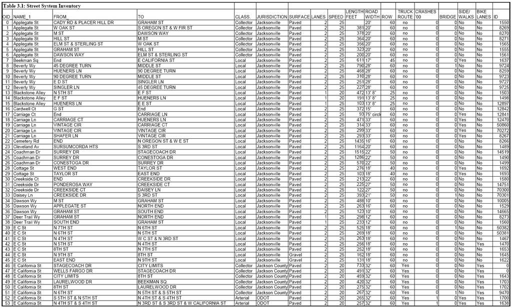
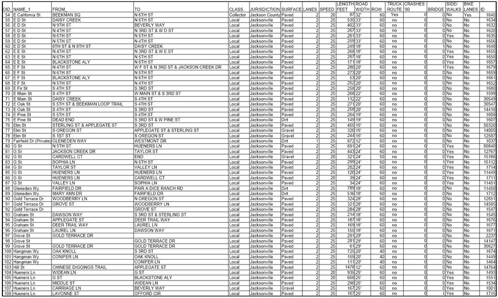
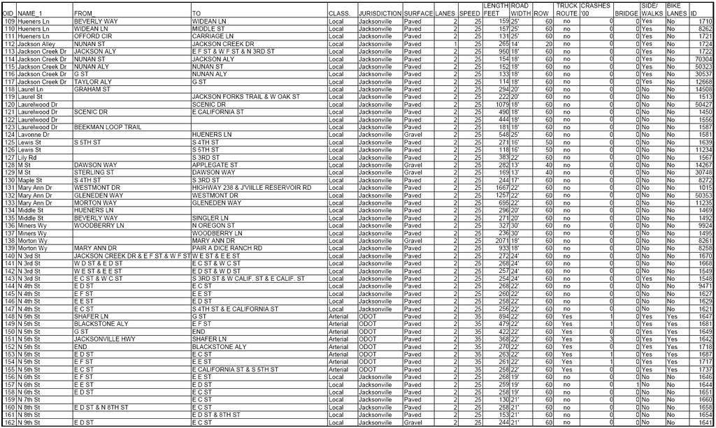
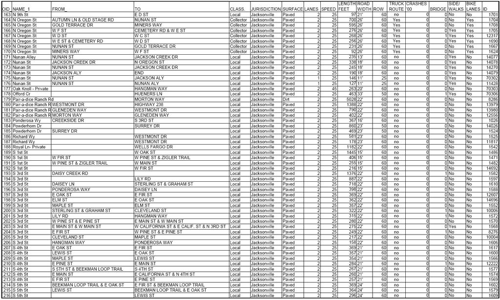
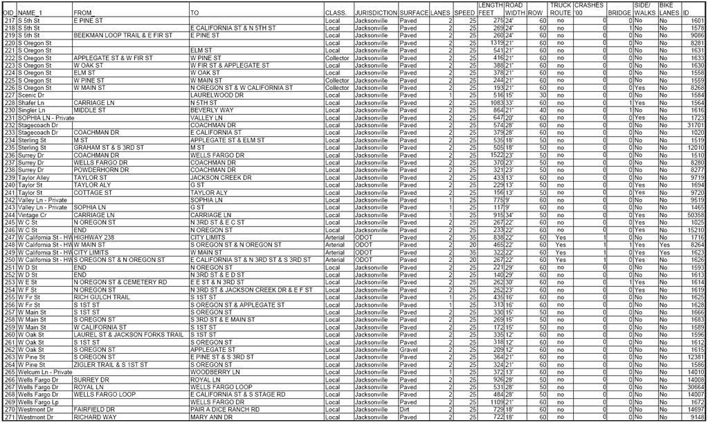
34 standards call for 4- to 5.5-foot bike lanes on both sides and sidewalks on one or both sides separated by a 3- to 5.5-foot buffer strip. Collectors: are an intermediate class, drawing traffic from the lower class local streets and funneling it to the higher class arterials. Collectors support traffic circulation but balance traffic needs with local land access. North and South Oregon streets in the downtown area, East California Street and Applegate Street are Jacksonville s collector streets. Existing standards vary, and collectors may or may not have bicycle lanes, sidewalks or parking. Local: By far the largest category of streets in Jacksonville, local streets are designated to provide land access. They carry traffic at low speeds to facilitate access and optimize safety for pedestrians and bicyclists. They should be designed to provide traffic circulation within small, neighborhood areas and not encourage short-cut uses that should be routed to collectors. Local streets feed the collectors. Parking generally is permitted on both sides of the street, and a pedestrian path or sidewalk may be provided on one side. Street standards depend on which of four zones a street is located. Local street standards very depending on the zone: Standard are intended primarily to protect historical resources. In some areas, decomposed granite is the standard sidewalk surface. The inventory of street network facilities shows all arterials, collectors and local streets. This section includes the inventory of public parking and pedestrian and bicycle facilities as they exist within the street-system rights-of-way. The inventory is presented in maps that begin on the next page, followed by table 3.1, which contains additional facility information. Traffic counts appear in Chapter 4. Intelligent Transportation System Planning The Rogue Valley Metropolitan Planning Organization has an Intelligent Transportation System Plan for the region that includes medium- and long-range projects in Jacksonville. Projects are: Automatic Traffic Recorder and Closed Circuit Television, Fifth Street at California Street, proposed for ; and Parking Management System, visitor information, associated with event management, at municipal parking lot at end of West C Street. Regarding pedestrians, the city has a system of pedestrian trails separate from the street system. The trail system is discussed in a separate bicycle-pedestrian section that follows the street system section. The parking inventory is discussed in section The street system map appears on the next page. The street inventory begins on the following page. Traffic count data is contained in Element 4. Jacksonville TSP 21
35 Figure 3.1: Study Area Street System Inventory Jacksonville TSP 22
36 Jacksonville TSP 23
37 Jacksonville TSP 24
38 Jacksonville TSP 25
39 Jacksonville TSP 26
40 Jacksonville TSP 27
41 3.2.2 Bicycle and Pedestrian Facilities The city figures prominently in the Southern Oregon pioneer history, but its contribution to bicycle safety has statewide and, some say, national significance. A modern day pioneering legislator and Jacksonville resident Donald Stathos championed a state law for funding bicycle lane construction in Stathos activism was prompted by his concern about the perils of riding a bike along Hwy. 238 between Jacksonville and Medford. His Oregon Bicycle Bill tapped state highway funds to finance bikeways and pedestrian paths. A 4-mile stretch of bicycle lane on Hwy. 238 was constructed under the state legislation and dedicated to Stathos in Advocates for such facilities subsequently set off a national movement for similar legislation, which now dedicates federal highway funds for pedestrian and bicycle improvements. Other roads around Jacksonville have wide shoulders and are popular with cyclists. The city is a popular stop for recreational cyclists using regional bike routes such as South Stage and Old Stage roads. As noted in the street network section, bicycle and pedestrian facilities that are within street system rights-of-way are included in the street network inventory, Table 3.1. All pedestrian and bicycle facilities are illustrated on the map on the following page: Jacksonville Sidewalk and Bike Lane Inventory. Beyond the street network, the city has two woodland pathway networks: the largest trail network includes the Peter Britt Festival Grounds, city-owned woodlands and U.S. Bureau of Land Management woodlands; the second weaves through city-owned woodland between South Fifth Street and Laurelwood Drive. The pathways also are shown on the sidewalk and bike lane map. Although these facilities serve a wide range of users, no facility expressly serves equestrians or two non-traditional vehicles that are growing in popularity Segways (battery-powered personal mobility devices) and golf carts. Under state law, Golf carts are permitted only in limited locations associated with golf courses. The only lawful use of a golf cart in Jacksonville would be by disability permit. Under ORS (3), a Disability Golf Cart Permit grants driving privileges for the operation of golf carts or substantially similar vehicles on roads or streets in an area with a speed designation not greater than 25 miles per hour. Golf carts also could be permissible on a multi-use path specifically developed for golf carts and not connected with the street network; Segway use is new, and has been governed by state law only since Operators must be at least 16 years old. The vehicles are permitted on bicycle lanes and paths, sidewalks, and roads with posted speed of 35 miles per hour or less. Operators must yield to pedestrians and warn then when they are about to be overtaken. Operators are exempt from license and helmet requirements, unless otherwise required by local government. Local jurisdictions may impose additional restrictions. Jacksonville TSP 28

42 Figure 3.2: Sidewalk and Bike Lane Inventory Jacksonville TSP 29
43 3.2.3 Public Transportation Public transportation in Jacksonville is provided by Rogue Valley Transportation District. Under guidelines contained in the Oregon Public Transportation Plan for service level standards transit service is at Level 1. RVTD meets Level 1 standards by providing the following services: 1. Senior and disabled public transportation 2. Intercity bus service 3. Serve citizens dependent on public transportation 4. Serve citizens using public transportation by choice 5. Offer rideshare and transportation demand management 6. Thruway bus service (provide by connection to Greyhound bus line) The basic services provided by RVTD are: Fixed-route bus service 13 or 14 hours each weekday, generally at ½ hour intervals. Paratransit service available to persons with disabilities traveling to and from points within ¾ mile of fixed bus routes. 24-hour advance reservations are required. Multi-modal incentive programs. Fixed-Route Service The district's fixed-route bus service has six bus routes totaling about 100 miles, serving seven communities and a number of rural county residents. Hours of operation are weekdays, 5 a.m. to 7:30 p.m. The route circulation is a spoke and wheel system, meaning that buses for all routes depart from the downtown station at the same times each hour, thus facilitating transfers between lines. This type of route design maximizes destination choices for passengers by ensuring that a rider can get to any stop in the system with no more than one transfer. However, it increases travel time for some passengers. Paratransit Service RVTD provides the Valley Lift paratransit service to people whose disabilities prevent them from using regular buses. By federal law, the paratransit service area extends to all locations within 3/4 mile of any fixed-route bus line. Hours of operation also mirror the fixed route service. Valley Lift provides users with curb-to-curb transportation upon request. Reservations must be received at least 24 hours prior to departure. Multi-Modal Incentives RVTD has a Transportation Demand Management (TDM) program that administers fare discount programs and works with employers to provide transit incentives to members of the region's workforce, including group fare discounts. One aspect of this effort is a Transportation Management Association (TMA) program, in which groups of employers work together with RVTD to provide transit incentives, reduce parking constraints, and provide infrastructure for non-automotive transportation modes. Jacksonville TSP 30
44 Ridership and Trends RVTD ridership has more than doubled since RVTD ridership is expected to more than double over the next ten years. In Jacksonville, weekday service to Medford is provided by Route 30, linking passengers to the Front Street, Medford, station, which provides connections to all other RVTD routes. Route 30 has the smallest ridership of all routes. Ridership figures from RVTD for show 19,415 riders annually on the route. As of June 2007, buses make nine round trips daily. The first bus arrives at the Jacksonville Post Office at 7:47 a.m., and that bus returns to Medford at 8:07 a.m. The last bus arrives in Jacksonville at 6:17 p.m., and that bus returns to Medford at 6:37 p.m. Table 3.2 shows the bus schedule at two Jacksonville locations. Table 3.2: RVTD bus stop schedule in Jacksonville, Spring 2007 Location Time JV P.O. 7:47 a 8:32 a 11:47 a 12:32 p 3:17 p 4:02 p 4:47 p 5:32 p 6:17 p Museum 7:49 a 8:34 a 11:49 a 12:32 p 3:19 p 4:04 p 4:49 p 5:34 p 6:19 p The bus approaches Jacksonville from the north, traveling southbound on Fifth Street, turning westbound on C Street to the post office, turning and traveling eastbound on California Street. The bus loops around the Jackson County Historical Society Museum (to North Sixth Street), and returns north to Medford on Fifth Street. Details about Jacksonville bus stops are shown on Table 3.3. Table 3.3: RVTD bus stops in Jacksonville Sign Trash Bike Wheelchair Stop Location Status Shelter Seating Can Rack Accessible From Medford to Jacksonville on Hwy ' south of Royal Mobile Estates driveway Yes No None No No No 5th St. 248' north of "G" St. (Pioneer Village) Yes Yes Bench No No Yes 5th St. 102' north of Blackstone Alley (Back Porch BBQ) Yes No None No No uncertain 5th St. 107' south of "F" St. (Ray's Market) Yes No None No No Yes From Jacksonville to Medford inside new parking lot C St. (behind Post Office) Yes No None No No Yes C St. west of 4th St. Yes uncertain D St. Jacksonville Museum / 27' east of 5th St. Yes No None No No uncertain 5th St. 150' north of Blackstone Alley near 35 mph sign Yes No None No No uncertain 5th St. 248' south of Shafer Ln. (Stage Lodge) Yes Yes Bench No No Yes A map illustrating RVTD s bus service to and around Jacksonville is on the following page. Jacksonville TSP 31

45 Figure 3.3: Public Transportation Inventory Jacksonville TSP 32
46 The bus route passes through a growing commercial and residential area along Fifth Street, which includes some of the highest-density housing and mixed commercialresidential housing in the city. These uses are cited in the Regional Transportation Plan s Alternative Measures as development patterns that encourage transit use and other alternatives to single-occupancy vehicle (SOV) use. By stopping at the post office, transit also accesses the adjacent municipal parking lot, enabling park-and-ride service to the Jacksonville area. A challenge to providing transit service in Jacksonville is the sparsely populated area between Jacksonville and Medford. Buses travel across a three-mile stretch of rural farmland between the city limits/urban growth boundaries of both cities. Jacksonville is surrounded by rural farm and forest land, so there is no opportunity to reroute buses through more densely developed areas. The distance to Jacksonville contributes to Route 30 s high cost. The cost per ride on Route 30 was $6.89 in , compared to the next highest cost per ride of $3.70. (Highest cost-per-ride route, Route 4, was discontinued in 2006 because of its high cost and low ridership.) Air, Water, Rail and Pipeline Inventory Air There are four public airplane facilities in Jackson County. The closest facility to Jacksonville is the Rogue Valley International-Medford Airport, located approximately 6 miles northeast of Jacksonville, off Biddle Road, Medford. Bus transport via RVTD is available during weekday hours of operation. It is classified as a non-hub facility serving roughly eight counties in southwestern Oregon. The airport serves eight hub airports in the Western states. Four air carriers currently serve the airport, with approximately 56 arriving and departing flights daily. The other three public airports are: Ashland Muni- Sumner Parker Field, Pinehurst State Airport, and Prospect State Airport. The Rogue Valley International-Medford Airport has just been upgraded with a major expansion. Construction is finished on a new terminal and will soon be completed on a new control tower. Work is being done in phases, with the final phases being completed in Rail Central Oregon and Pacific (CORP) operates a shortline route through the region connecting to national Union Pacific line in Eugene. The CORP line passes through Medford, roughly 5 miles from Jacksonville. In the past few years, some interest has been expressed in recreating the former Rogue Valley Railroad, which ran between Jacksonville and Medford from 1891 to the 1920s. Conceptual service would run to the C Street train station, where a section of rail still is visible embedded in the pavement. The line would make a loop out to the Little League fields on Jacksonville Highway, where it could pick up Britt passengers at a proposed parking lot at the back of the park, or proceed toward Medford across private property on Jacksonville TSP 33
47 the northeast side of town. Within city limits, only a remnant of the old rail right-of-way exists today in public ownership owned as a tax lot. It is a narrow, 1.48-acre strip approximately 1,300 feet long running south and roughly parallel to Hueners Lane. Between the city and Medford, the county owns an easement for rail purposes, which is largely intact; the intent is to preserve the easement for nonmotorized travel. Pipeline The only pipeline facility in the city is owned by natural-gas provider Avista Utilities. Avista makes natural gas available to most households in the city (not the northwest quadrant). Natural gas is transmitted from the north via the Williams Pipeline generally located along the I-5 corridor. Water There are no navigable waterways in or serving the city Parking Inventory Most of the parking supply is on-street parking, although three parking lots one private and two city-owned help meet the surge in parking demand associated with the Britt Festivals series of outdoor summer concerts. The Britt concerts, coupled with the seasonal increase in tourism, tends to tax the supply of parking, in particular parking close to popular destinations. Those destinations are the core business district shops along or just off East California Street, and the Britt grounds at First and West Fir streets. On the afternoon-evening of a concert, Jacksonville can expect roughly 880 Britt-bound vehicles. This estimate is based on the capacity of Britt grounds 2,200 people and an average vehicle capacity of 2.5 people. The estimate assumes that concertgoers will arrive by motor vehicle as public transportation is not available. Festival grounds capacity is reported by Britt Festivals, and assumes sold-out concerts. The average vehicle capacity of 2.5 was established for outdoor summer concerts in the Rogue Valley Metropolitan Planning Organization area by the 2001 Jackson County Expo & Fair Amphitheater Traffic Control Plan. Although Jacksonville offers overnight accommodations and a few Britt attendees could stay in the city and walk to the concert, accommodations are very limited and are not likely to significantly impact traffic. Inventory A parking inventory was conducted, focusing on the availability of parking surrounding the downtown area, where parking often is perceived of being in short supply. The inventory identified 603 on-street parking spaces and 485 off-street spaces. The only public off-street parking is the 180 spaces in the city-owned lots at the end of West C and West D streets. The largest area of off-street parking about 250 spaces is owned by Bigham Knoll, which makes the lot available to Britt concert-goers. The inventory appears in Table 3.4A and B, on the following page. The area covered in the inventory is identified by the numbered blocks shown on Figure 3.4, following the inventory counts. Jacksonville TSP 34
48 The inventory is a rough calculation because most of the on-street parking is not paved or marked, allowing motorists to leave their vehicles where convenient, but not necessarily where most efficient, i.e. one car taking up what could be two spaces. The inventory reflects an optimal use of unmarked space. Additionally, the city has a considerable amount of parking in the neighborhoods surrounding the Britt grounds where on-street parking is reserved for residents by permit from June 1 to September 30 (shown as Restricted Parking in inventory tables). The restriction helps mitigate the impacts of concerts on nearby households, and the area involved is too far from other points of interest to impact other visitors. Jacksonville TSP 35


49 Table 3.4.A: Parking Inventory, North City Table 3.4.B: Parking Inventory, South City Tables above show the total number of parking spaces by category (on-, or off-street). Restricted parking limits parking to permit holders from June 1 through September 30. Excluding the restricted parking, there are 1,088 parking spaces in the downtown area as shown on Figure 3.1 on the following page. Jacksonville TSP 36

50 Figure 3.4: Parking Inventory Map The numbers on the blocks shown above correspond to the block numbers in the inventory on the previous page. DRAFT Jacksonville TSP 37
51 Element 4 Current Conditions and Deficiencies 4.1 Introduction This element describes the current operating condition of the street network and identifies where and to what extent deficiencies exist. The findings of the existing conditions analysis serve as a baseline to which future conditions can be compared and evaluated. This element is, essentially, a fact-finding document. It combines the information from Element 3 s inventory with traffic counts at key intersections to create a picture of the transportation system. The analysis includes examination of traffic controls and road geometrics, and addresses bicycle and pedestrian activities. It determines current (2006) intersection level of service (LOS) and volume to capacity (V/C) ratios. The findings are based on analysis by traffic engineering staff at Parametrix, using a standardized method for determining traffic flow by adjusting for variations in traffic hourly, daily and seasonally. In addition, a second engineer s analysis looks at traffic conditions during two times of high activity: Britt Festivals concert nights and Sunday mornings due to traffic volumes generated from parcels west of the townsite. This second analysis also identifies and evaluates potential alternatives, which will be taken up in Element 6: System Alternatives. 4.2 Summary of Findings All 12 intersections examined in this review were found to be operating within generally acceptable levels. Lowest-performing intersections were found along North Fifth Street: the west-bound left turn movement from Shafer Lane, and all travel eastbound from West E Street. Both performed at a service level (LOS) of C, which is adequate according to city standards and means that the delay for motorists making these movements is not excessively long. All other intersections in the city were LOS B. V/C ratios, which compare traffic flow to a roadway s capacity, also were well within acceptable standards. Details are provided below. Findings regarding traffic flow during special events are contained in section DRAFT Jacksonville TSP 38
52 4.3 Existing Conditions The purpose of this section is to establish the existing conditions (2006) of the study area roadways and intersections. This section does not include a comprehensive assessment of all existing conditions, but focuses solely on traffic analysis Study Area The analysis of existing traffic conditions within the Jacksonville study area focuses on twelve key intersections located primarily along Hwy. 238 (Jacksonville Highway) through the City. Five other local intersections are also included in the study area. All study area intersections are unsignalized and include the following: 1. Hwy. 238 at Shafer Lane; 2. Hwy. 238 (Fifth Street) at E Street; 3. Hwy. 238 (Fifth Street) at California Street; 4. California Street at Sixth Street; 5. California Street at Eighth Street; 6. California Street (South Stage Road) at Wells Fargo Road; 7. Hwy. 238 (California Street) at Third Street; 8. Hwy. 238 (California Street) at Oregon Street; 9. Oregon Street at F Street; 10. Oregon Street at C Street; 11. Hwy. 238 at Pair-a-Dice Road; and, 12. Hwy. 238 at Old Ore 238 (Bybee Corner, outside city urban growth boundary) Each of the unsignalized intersections is stop-controlled on the minor street approach. Existing traffic volumes for the 12 study area intersections (traffic counts with seasonal adjustments) are shown in Appendix B. Existing lane configurations and traffic control are shown in Appendix C and photographs of the study area intersections are presented in Appendix D. Posted speeds in the vicinity of study area intersections are as follows: Hwy. 238 at Old Hwy.238 (Bybee Corner) 45 mph; Hwy.238 at Shafer Lane 30 mph; Hwy.238 from north of E Street through west of Oregon Street 20 mph; Hwy.238 at Pair-a-Dice Road 45 mph; California Street from Fifth Street to Wells Fargo Road 25 mph; Oregon Street from California Street through C Street 20 mph; and, Oregon Street at F Street 25 mph Existing Traffic Counts Peak Period Turning Movement Counts ODOT and the Rogue Valley Council of Governments provided turning movement counts for Jacksonville study area intersections. For most intersections, the counts were conducted for three hours between 3 and 6 p.m., and included vehicle classification by movement. At the intersections of Hwy. 238 with Old Hwy. 238 (Bybee Corner), and Fifth Street with California Street data was collected for 16 hours between 6 a.m. and 10 p.m. At the intersections of Hwy. 238 (California Street) with Oregon Street, and Hwy. 238 with Pair-a- DRAFT Jacksonville TSP 39
53 Dice Road, data was collected for 14 hours between 6a.m. and 8 p.m. Data for each intersection was disaggregated into 15-minute time increments for the PM peak travel periods to facilitate analysis. A review of traffic count data indicated that average traffic activity in the study area over the entire peak period was highest from 4:45 p.m. to 5:45 p.m. Data presented in Table A-1 of Appendix C illustrates how this determination was made from the raw count data provided by ODOT. Table A-2 shows the total volumes for each movement and intersection during the identified peak hour. Hwy. 238 (No. 272) traffic can be characterized as both commuter and recreational with significant seasonal variation occurring between summer and winter months. Accordingly, adjustments are required for the counts taken outside of the peak season to ensure that they reflect an appropriate level of traffic for use in assessing design/improvement options. Since there is no Automatic Traffic Recording station (ATR) close by or representative of the study area the ATR Seasonal Trend Table was used to determine adjustment factors. Adjustment factors were calculated averaging summer and commuter seasonal factors. The factors to seasonally adjust the peak hourly traffic counts are presented in Table A-3 of Appendix B. The seasonally adjusted peak hour turning movement traffic counts that formed the basis of the existing conditions traffic operations analysis are summarized in Table A-2 of Appendix B. These volumes represent 30th highest hourly volumes that can be used as the basis for evaluation of improvement options. Medium and Heavy Duty Truck Counts Table 4.1 summarizes the percentage of total traffic on various roadway segments in the City of Jacksonville during the PM peak hour that is attributable to medium and heavy duty trucks. This data was collected for ODOT during August of As indicated in the table, average percentages for medium and heavy duty trucks vary from 0.6 percent on California Street east of Wells Fargo Road to 3.1 percent along Hwy. 238 in the vicinity of Pair-a-Dice Road. Table 4-1: Medium and heavy-duty truck traffic as percent of total traffic during p.m. peak hour at selected locations. Medium and Heavy Duty Trucks Heavy Duty Trucks Location and Time Period Total 2-Way Traffic Volume Percentage Volume Percentage Hwy. 238 north of Shafer Lane % 3 0.4% Hwy. 238 north of E Street % 5 0.8% Hwy. 238 east of Third Street % 4 0.6% Hwy. 238 east of Oregon Street % 3 0.5% Hwy. 238 east of Pair-a-Dice Road % 8 1.4% Hwy. 238 west of Pair-a-Dice Road % 8 1.5% California Street east of Wells Fargo Road % 3 0.5% Note: Medium duty trucks include single units with three or four axles, heavy duty trucks include double or multiple units with four to more than 6 axles. DRAFT Jacksonville TSP 40
54 Heavy duty truck percentages also vary throughout the study area with the higher percentages near Pair-a-Dice Road. However, overall percentages of heavy duty trucks are relatively small during the PM peak hour ranging from 0.4 percent north of Shafer Lane to 1.5 percent west of Pair-a-Dice Road. Heavy duty trucks typically affect intersection and roadway traffic operations more significantly than do smaller trucks and are always considered as a part of a traffic operations analysis. A possible shortcoming to addressing traffic only in terms of overall p.m. peak hour traffic conditions is that the peak of truck traffic associated with quarry activity off Pair-a-Dice Ranch Road is missed. The greatest number of trucks to and from the quarry area passes through the city during the morning hours. A one-day snapshot of truck traffic serves as an example of this truck traffic through the city. This snapshot captures trucks traveling north and south on Hwy. 238 between Pair-a-Dice Ranch Road, north of the city, and the intersection of California and Oregon Streets. Pair-a- Dice Ranch Road is the only access to a granite quarry. There are no intersections on Hwy. 238 between Pair-a-Dice Ranch Road and Oregon Street, so all southbound trucks at the Pair-a-Dice Ranch Road/Hwy. 238 intersection must pass through the California/Oregon intersection. Likewise, all northbound trucks at the Pair-a-Dice Ranch Road/Hwy. 238 intersection had to have passed through the California/Oregon intersection. In other words, a count of trucks entering and exiting Pair-a-Dice Ranch Road at Hwy. 238 from Jacksonville represents truck traffic in the city at California and Oregon streets. Table 4.2, below, shows the numbers of trucks, 3-axle and greater, counted in one day in mid-august, The count showed that for the remainder of the day (through 8 p.m.), a total of seven trucks passed California and Oregon streets intersection to and from Pair-a-Dice Ranch Road. Aggregate hauling activity is determined by market needs and business strategies. Volumes, therefore, are subject to significant change, short term and long term. Table 4.2: Truck traffic a.m. hours at California and Oregon Streets, to and from Pair-a-Dice Ranch Road. Hour Trucks North-Bound (Jacksonville to Pair-a- Dice Ranch Road) Trucks South-Bound (Pair-a-Dice Ranch Road to Jacksonville) Total California & Oregon streets 7 a.m a.m a.m a.m a.m Noon Table 4.2 reports the number of trucks on Pair-a-Dice Ranch Road that also travel through the intersection of California and Oregon streets, thereby impacting Jacksonville s historic downtown core area. Morning hours typically are the hours of highest truck volumes. Hwy. 238 is a local route linking Interstate 5 at North Medford and US 199 in Grants Pass. As such it carries regional commercial traffic to and among the two cities and smaller communities along its route. This north-south through truck traffic also impacts Jacksonville. Table 4.3 shows the total number of through trucks, 3-axle and greater, at California and Oregon streets in the same period as table 4.2 above. Truck traffic is identified as mediumduty (3 to 4 axles) and heavy-duty (more than 4 axles). Comparing the total volume of trucks in 4.3, to the totals in table 4.2 shows the impact of regional truck traffic in the city. An DRAFT Jacksonville TSP 41
55 unknown percentage of the trucks in Table 4.3 are locally generated (i.e. deliveries to and from Jacksonville locations). Table 4.3.a.: Truck Traffic at California and Oregon streets. Medium and Heavy Duty Trucks Heavy Duty Trucks Hour Total Traffic Volume Percentage Volume Percentage 6 a.m % % 7 a.m % % 8 a.m % 5 0.7% 9 a.m % % 10 a.m % % 11 a.m % % Noon % 6 0.6% Table 4.3.a. reports the number percentage of trucks at CA/OR streets compared to all classes of traffic passing through the intersection. Morning hours typically are the hours of highest truck volumes. Table 4.3.b.: California/Oregon Streets truck traffic, unadjusted for peak hour Hour 7/10/2008 7/16/2008 8am-9am am-10am am-11am am-12pm Table 4.3.b. reports counts as of 7/10/2008 & 7/16/2008 submitted by a Jacksonville citizen. Counts have been aggregated to show the total number of tractor-trailer trucks passing through the CA/OR intersection at the times indicated. Bicycle Counts Table 4.4 presents a summary of bicycle travel at key study area intersections based on traffic count data collected for ODOT during August, As indicated by this summary, bicycle travel currently constitutes a relatively low percentage of total traffic during the peak travel hour of the day. The counts, taken on a weekday, don t reflect the city s position that it is a popular stopping point for recreational cyclists using regional bike routes such as South Stage and Old Stage roads. Table 4.4: Peak Hour Bicycle Traffic at Key Intersections Location Total Traffic Approaching Intersection Total Bicycles Approaching Intersection Bicycle Traffic percent of total Hwy. 238 at Shafer Lane % Hwy.238 at E Street % Hwy.238 at California Street % California Street at Wells Fargo % Road Hwy.238 at Third Street % Hwy.238 at Oregon Street Hwy.238 at Pair-a-Dice Road Hwy.238 at Main St. (Bybee Corner) 1, DRAFT Jacksonville TSP 42
56 Pedestrian Counts Table 4.5 presents a summary of pedestrian activity at key study area intersections based on traffic count data collected for ODOT during August of Table 4.5: Peak Hour Pedestrians at Key Intersections Total Pedestrians Crossing at Location Intersection Hwy.238 at Shafer Lane 0 Hwy.238 at E Street 7 Hwy.238 at California Street 0 Hwy.238 at Third Street 94 Oregon Street at F Street 4 Oregon Street at C Street 1 Hwy.238 at Main Street (Bybee Corner) Existing Traffic Operations Operational Standards Within the state of Oregon traffic operations are evaluated based on two sets of criteria or standards. For state highways, the operative standard is expressed in terms of a ratio between traffic volumes and the roadway or intersection s capacity (or V/C ratio). For many local communities, the quality of traffic performance is assessed in terms of intersection or roadway levels of service (LOS) which is based on average delay. These two operational standards are described below. Volume to Capacity Ratios As adopted in the 1999 Oregon Highway Plan (OHP), ODOT uses volume-to-capacity (V/C) ratios to measure state highway performance rather than intersection or roadway levels of service. Various V/C thresholds are applied to all state highways based on the OHP defined highway classification of these facilities. Oregon Highway 238 (Jacksonville Highway) is classified by the OHP as a district highway. The peak hour maximum V/C standards for Hwy. 238 locations and are summarized in Table 4.6. Table 4.6: Maximum Volume to Capacity Ratios for Peak Hour Operating Conditions Maximum V/C District Highway Designation Ratio Outside Urban Growth Boundary Rural Lands 0.75 Inside MPO, outside STA boundary STA: Main Street to Shafer Lane (MP33.16 to 33.97) 0.95 Source: Oregon Highway Plan, Policy 1F Mobility Standards, Table 6. Intersection Levels of Service Another measure of intersection operating performance during peak travel periods is based on average control delay per vehicle entering the intersection. This delay is calculated using equations that take into account turning movement volumes, intersection lane geometry and traffic signal features, as well as characteristics of the traffic stream passing through the intersection, including time required to slow, stop, wait, and accelerate to move through the intersection. Various levels of delay are then expressed in terms of levels of service (LOS) DRAFT Jacksonville TSP 43
57 for either signalized or unsignalized intersections. The various levels of service range from LOS A (which reflects free-flow conditions) through LOS F (which reflects operational breakdown). Between LOS A and LOS F progressively higher LOS grades reflect increasingly worse intersection performance, with higher levels of control delay and increased congestion and queues. Characteristics of each LOS are briefly described below in Table 4.7. Table 4.7: Level of Service Definitions Average Delay/Vehicle (sec.) Level of Service Signalized Unsignalized Description A (Desirable) <10 seconds <10 seconds Very low delay; most vehicles do not stop. B (Desirable) >10 and <20 seconds C (Desirable) >20 and <35 seconds D (Acceptable) >35 and <55 seconds E (Unsatisfactory) >55 and <80 seconds >10 and <15 seconds >15 and <25 seconds >25 and <35 seconds >35 and <50 seconds Low delay resulting from good progression, short cycle lengths, or both. Higher delays with fair progression, longer cycle lengths, or both. Noticeable congestion with many vehicles stopping. Individual cycle failures occur. High delay w/ poor progression, long cycle lengths, high V/C ratios, and frequent cycle failures. F (Unsatisfactory) >80 seconds >50 seconds Very long delays, considered unacceptable by most drivers. Often results from over-saturated conditions or poor signal timing. Source: 2000 Highway Capacity Manual, Transportation Research Board. Summary of Existing Traffic Operations The analysis of existing PM traffic operations was conducted using a Synchro traffic simulation model which was developed specifically for study area intersections. This model includes geometrics, other relevant physical data, and existing traffic control for each intersection that were identified from field reconnaissance. Analysis procedures follow the ODOT Transportation Planning and Analysis Unit s (TPAU) guidelines. Table 4.8 summarizes existing (2007) traffic operations for the PM peak hour at the twelve intersections in the Jacksonville study area. Data in this table includes the overall intersection volume-to-capacity (V/C) ratios, average intersection delay, and intersection levels of service. The V/C ratio relates the magnitude of traffic traveling through an intersection with its theoretical capacity. Ratios above 1.0 often accompany LOS E and LOS F conditions indicating inadequate capacity for one or more major movements. At intersections operating at LOS D or better, V/C ratios above 1.0 are useful indicators of potential concerns such as sub-optimal signal timing or inadequate turn lane storage. The 2007 intersection analysis worksheets are included in Appendix E. Currently the intersections generally experience minimal delays and operate within the acceptable V/C standards. DRAFT Jacksonville TSP 44
58 Table 4.8: Existing (2007) 30th Highest Hourly (Peak) Intersection Traffic Operations Unsignalized Intersections Critical Movement V/C Ratio Control Delay (secs./vehicle) Shafer Lane WB Left C Hwy.238 (5th E Street EB All C WB All B Hwy.238 (5th Hwy.238 (California Street) 3-way Stop B California Sixth Street SB All B California Eighth Street SB All B California Wells Fargo Road NB All B Hwy.238 (California Third Street NB All B SB All B Hwy.238 (California Oregon Street All-way Stop LOS B Oregon F Street WB All B Oregon C Street EB All B WB All B Pair-a-Dice Road SB All B Old Hwy.238 (Bybee Corner) NB Left C WB Left A Note 1: LOS means intersection level of service. Note 2: Critical Delay and Critical LOS refers to the delay or LOS experienced for the specific intersection traffic movement listed. Note 3: NB means northbound, SB means southbound, EB means eastbound, WB means westbound Special Event Operations Two recurring special events create a rush of traffic to and through the city: Britt Festivals summer concert series in Jacksonville, and heavy Sunday traffic generated by parcels to the southwest of town. Traffic and pedestrian counts were taken in August 2006 on a Sunday morning and an evening of a Britt concert to identify impacts at the intersection of West California and Oregon streets. Greenlight Engineering, Tualatin, reviewed the counts and found that while the intersection works adequately during a Britt concert, it does not work adequately when Sunday morning through traffic reaches a peak. The analysis found that traffic operations at the intersection are compromised for a brief time on Sunday midday. With a delay of 53 seconds, the intersection performed at LOS F. During the peak of Britt traffic, the delay was no longer than typical for the intersection, LOS B. DRAFT Jacksonville TSP 45
59 Element 5 Future Demand, Deficiencies and Needs 5.1 Introduction This element looks at the city s transportation system in terms of how well or poorly in can be expected to function through It describes anticipated travel demand and the capacity of the transportation network, and identifies deficiencies and needs that might exist. Deficiencies, in this case, are defined as the differences between the characteristics of the future transportation system and the performance standards that are already in place to measure performance of those characteristics. Needs are defined as the kind of transportation improvements or changes that will be necessary to correct or mitigate the deficiencies. The element begins with a description of the procedures and methodologies used to forecast demand, the standards used to determine whether there will be any deficiencies and needs, and the information and data used to make the traffic forecasts. The element concludes with the analysis of future (2030 peak period) transportation conditions under two scenarios. Beyond offering a window into the future performance of Jacksonville s transportation system, the analysis serves as the basis for evaluating the benefits various land development and transportation alternatives. The identification and analysis of potential alternatives will be taken up in Chapter 6: System Alternatives. 5.2 Summary of Findings The analysis showed that by 2030, no intersections in Jacksonville are expected to exceed the applicable intersection traffic operation standard, and therefore, no needs are identified. This was true under a No Build scenario, which considered development and transportation system changes as identified in current planning documents, and a Mode-Loss scenario, which considered impacts of the loss of transit service and bicycling. Tables 5-5 and 5-6 at the end of this chapter detail these findings. Future-year findings echo analysis of present day performance. Intersections examined for 2007 performance (Element 4) were found to be operating within generally acceptable levels. Lowestperforming intersections were along North Fifth Street: the west-bound left turn movement from Shafer Lane, and all travel eastbound from West E Street. Both performed at a Level of Service (LOS) of C, which is adequate according to city standards and means that the delay for motorists making these movements is not excessively long. Under the two 2030 scenarios, service declined to LOS C on several streets, with an LOS D (still within city standards) on the west-bound left Jacksonville TSP 46
60 turn movement from Shafer Lane. A summary comparison of current and future intersection performance is shown in table 5-1 below. Table 5.1: Summary Comparison of Intersection Performance, 2007 and 2030 Unsignalized Intersections Critical Movement 2007 LOS 2030 LOS Hwy. Shafer Lane WB Left C D Hwy.238 (5th E Street EB All C C WB All B C Hwy.238 (5th Hwy.238 (California Street) 3-way stop 1 yield B B California 6th Street SB All B C California 8th Street SB All B C California Wells Fargo Rd NB All B C Hwy.238 (California 3rd St NB All B B SB All B B Hwy.238 (California Oregon Street All-way Stop B C Oregon F Street WB All B B Oregon C Street EB All B B WB All B B Pair-a-Dice Road SB All B C W. Main (Bybee Corner)* NB Left (W. Main) C E WB Left A A *Outside study area/jacksonville UGB, but import to understanding city travel Forecast Methodology This section describes the forecasting methodology employed to prepare future year traffic volumes for the Jacksonville Transportation System Plan update. It includes discussion of the following: A brief discussion of the data sources and analysis process employed to prepare future link and intersection turning movement projections to be used in assessing the traffic implications of population growth and land development within the study area and the surrounding community; A synopsis of the standards used to assess needs and deficiencies; A summary of planned city, county and/or ODOT roadway improvement projects in the study area; and A brief discussion of traffic model output at the street segment or link level to identify any locations that are anticipated to exceed planned capacity during the planning period. As appropriate, data would be stratified in 5 year increments to assist in determining the priority and timing of future recommended improvements Traffic Forecasting Process Traffic forecasts for the Jacksonville study area were developed to compare and assess the anticipated roadway system improvement needs associated with the future peak hour No-Build condition and an array of transportation system alternatives. A multi-step process was undertaken to prepare these forecasts which relied on the Rogue Valley Metropolitan Planning Jacksonville TSP 47
61 Organization s (RVMPO) travel demand model developed and maintained for the Jacksonville urbanized area by the ODOT Transportation Planning Analysis Unit (TPAU). For purposes of this study the future planning horizon year was assumed to be 2030, consistent with other transportation planning activities currently underway within the region. The travel demand model uses current and projected land use to estimate travel demand. Estimates were prepared for two land use/transportation system alternative scenarios, a base year of 2005 and future year of It should be noted that the RVMPO model includes the entire area within the Jacksonville Urban Growth Boundary (UGB), as well as expansion areas currently located outside the UGB. The travel demand forecasting process used to obtain future intersection level traffic volumes included the following steps: 1. Using traffic volume assignment output from the RVMPO model as supplied by TPAU, 2005 and 2030 peak hourly traffic volume estimates were prepared for street segments approaching key intersections throughout the Jacksonville study area. These estimates are based on land development consistent with the local city and Jackson County comprehensive plans and on the transportation system improvements anticipated to be in place by 2030 as denoted in the Rogue Valley Regional Transportation Plan (RTP) peak hour trip assignments from the model were compared with 2005 trip assignments to determine the extent of traffic growth anticipated on each roadway link in the study area. The roadway segment volumes for 2005 were subtracted from the 2030 volumes to determine the net difference in trips. The net difference was then divided by 25 years to yield an annual increase in trips. The annual trip increase was multiplied by 23 year to determine the increase in trips from 2007 to Future traffic growth on each link approaching a key intersection was added to existing turning movement traffic counts using the methods specified in NCHRP Report #255 to produce smoothed 2030 PM peak hour turning movement projections. This involved proportioning the additional link volume entering each intersection to each turning movement according to the 2007 turning movement data. The turning movement estimates for each of the scenarios were rounded to the nearest 5 trips and balanced between each of the study intersections to be less than 10 percent of the link volume Operational Standards Within the state of Oregon traffic operations are evaluated based on two sets of performance measures or standards. For state highways, the operative standard is expressed in terms of a ratio between traffic volumes and the roadway or intersection s capacity. For local street intersection within the City of Jacksonville, the quality of traffic performance is assessed in terms of intersection or roadway levels of service (LOS). These two operational standards are described below. Volume to Capacity Ratios As adopted in the 1999 Oregon Highway Plan (OHP), ODOT uses volume-to-capacity (V/C) ratios to measure state highway performance rather than intersection or roadway levels of Jacksonville TSP 48
62 service. Various V/C thresholds are applied to all state highways based on functional classification of these facilities. Hwy. 238, (Hwy No. 272) or Jacksonville Highway, within the study area is classified by the OHP as District Highway inside the boundaries of a Metropolitan Planning Organization (MPO). A segment of Hwy. 238 in Jacksonville, from Shafer Lane to Main Street has also been designated as a special transportation area (STA) which accommodates higher levels of congestion than would otherwise be the case along a highway of this type. The adopted v/c standards for OR 238 are presented in Table 5-2. Table 5.2: Maximum Volume/Capacity for Peak Hour Operating Conditions for District Highway Location Designation Maximum V/C Ratio Outside Urban Growth Boundary Rural Lands 0.75 Within Urban Growth Boundary STA (Shafer Lane to Main Street) 0.95 Within Urban Growth Boundary < 35 mph 0.90 Within Urban Growth Boundary MPO(1) 0.90 Source: Oregon Highway Plan, Policy 1F Mobility Standards, Table 6 Highway Design Manual The Highway Design Manual (HDM) prescribes v/c ratio standards for all major highway improvements. It is different from the OHP standards in that the OHP standards are for planning purposes, and the HDM standards are used when considering any design alternatives. If the acceptable v/c ratio cannot be met, it is necessary to seek a design exception. Table 5-3 lists the acceptable v/c ratios for future design options for Hwy Table 5.3: 20 Year Design-Mobility Standards (Volume/Capacity [V/C]) Ratio for District/Local Interest Roads Location Designation Maximum V/C Ratio Outside Urban Growth Boundary Rural Lands 0.70 Within Urban Growth Boundary STA (Shafer Lane to Main Street) 0.95 Within Urban Growth Boundary MPO 0.85 Source: Oregon Highway Design Manual, Transportation Analysis Table 10-4 Intersection Levels of Service Another measure of intersection operating performance during peak travel periods is based on average control delay per vehicle entering the intersection. This delay is calculated using equations that take into account turning movement volumes, intersection lane geometry and traffic signal features (no traffic signals exist within the study area), as well as characteristics of the traffic stream passing through the intersection, including time required to slow, stop, wait, and accelerate to move through the intersection. Various levels of delay are then expressed in terms of levels of service (LOS) for either signalized or unsignalized intersections. The various levels of service range from LOS A (which reflects free-flow conditions) through LOS F (which reflects operational breakdown). Between LOS A and LOS F progressively higher LOS grades reflect increasingly worse intersection performance, with higher levels of control delay and increased congestion and queues. Characteristics of each LOS are briefly described below in Table 5-4. The City of Jacksonville has adopted LOS C as its operative standard for local intersection traffic performance and LOS D for collector and arterial intersections. Jacksonville TSP 49
63 Table 5.4: Level of Service Definitions Average Delay/Vehicle (sec.) Level of Service Signalized Unsignalized Description A (Desirable) <10 seconds <10 seconds Very low delay; most vehicles do not stop. B (Desirable) >10 and <20 seconds C (Desirable) >20 and <35 seconds D (Acceptable) >35 and <55 seconds E (Unsatisfactory) >55 and <80 seconds >10 and <15 seconds >15 and <25 seconds >25 and <35 seconds >35 and <50 seconds Low delay resulting from good progression, short cycle lengths, or both. Higher delays with fair progression, longer cycle lengths, or both. Noticeable congestion with many vehicles stopping. Individual cycle failures occur. High delay with poor progression, long cycle lengths, high V/C ratios, and frequent cycle failures. F (Unsatisfactory) >80 seconds >50 seconds Very long delays, considered unacceptable by most drivers. Often results from over-saturated conditions or poor signal timing Funded Transportation Improvement Projects As noted in section 5.3.1: a key component of the Traffic Forecasting Process was to identify and factor in the transportation system improvements anticipated to be in place by 2030, as denoted in local, state and regional plans. There are very few roadway or intersection improvement projects currently identified and funded in the short-range plans and programs of ODOT, the City of Jacksonville or Jackson County within the study area. Projects that have been identified include the following: Oregon Department of Transportation Projects The current State Transportation Improvement Program (STIP) for includes one project in the City of Jacksonville. The project, on Elm and M Streets, will pave and improve the streets, adding sidewalks and bike lanes. Construction is scheduled to begin in Regional and County Projects The Rogue Valley Regional Transportation Plan (RTP) as published in 2005 by the Rogue Valley Metropolitan Planning Organization includes a wide variety of regional and local agency projects throughout the urbanized area. It should be noted, however, that the time frame for implementation of these projects could stretch longer than the short-range future. The first project listed below (Pair-a-Dice Ranch Road: OR 238 to Westmont) is on the RTP Tier 1 (financially-constrained) project list, meaning that construction could be accommodated within the existing anticipated financial resources of the area. The second project would require a new and not presently identified funding source, and is listed in the RTP as Selected Regional Project with Long Term Potential. These projects in detail: Pair-a-Dice Ranch Road: OR 238 to Westmont a fully funded project to install walkways along this roadway segment. Jacksonville TSP 50
64 Pair-a-Dice Ranch Road: OR 238 to City Limits this project is currently unfunded and would involve construction of an arterial connector around the central, historically-significant portion of the city. This new/improved facility would provide an alternative to traversing the core area for existing and anticipated vehicular traffic, particularly trucks, which are not conducive to supporting the ambiance of the historic downtown. Also, significant traffic congestion is experienced on Sundays from traffic generated on parcels located west of the townsite. 1 As noted in the Jackson County TSP, diversion of through truck traffic away from the downtown core area is an important problem affecting the general livability of the City of Jacksonville and that development of an alternative connector around the north edge of town should be closely coordinated with the county. City of Jacksonville Projects No street or roadway improvement projects have been identified as fully funded Potential Future Congestion Locations An assessment was made of roadway segments in the study area to determine whether future congestion problems may occur and, if so, the approximate timing of these problems in five-year increments between 2005 and To accomplish this assessment, traffic volume projections produced by the RVMPO model were reviewed and compared with estimated roadway capacities (also as determined by the model) for both 2005 and 2030 peak hours of travel. The intent of this assessment was to: 1. Identify locations where a volume-to-capacity ratio of greater than 0.80 (or 80 percent of theoretical roadway segment capacity) would be experienced; and 2. If such segments were identified, to then work backward to determine the point between 2005 and 2030 at which this v/c threshold would be exceeded. Based on the assessment that was conducted, no roadway segments were identified where 2030 peak hourly v/c ratios of 0.80 or greater would occur. Section 5.4 provides further analysis. 5.4 Intersection and Roadway Segment Evaluation This section contains the analysis of future (2030 peak period) transportation conditions in Jacksonville, documenting future traffic-volume growth at key intersections and identifying impacts and infrastructure requirements associated with future growth. The standards described in the preceding sections were applied to the volume forecasts to assess the impacts. Because the standards applied (v/c and LOS) to projected volumes are the same as standards applied to current (2007 volumes) in Element 4, it s possible to compare existing system performance to future performance. The information is intended to be used to support further development of the city s TSP by providing the basis for evaluating various land development or transportation 1 Letter from Greenlight Engineering to Paul Wyntergreen of the City of Jacksonville dated, February, 2007 documenting traffic operations analysis at the intersection of California and Oregon Streets for various peak time periods. Jacksonville TSP 51
65 alternatives in the study area. The expected traffic operational conditions that could be associated with each scenario will be identified and discussed in detail in Element 6. The section begins with description of the development of future 2030 traffic volumes. It continues with the results of intersection traffic operations analysis for two scenarios. One scenario the No-Build scenario is based on assumed improvements identified in the Rogue Valley Regional Transportation Plan, which articulates not only a variety of roadway improvement projects, but also anticipates a level of person travel via transit, walking or bicycling. The second scenario assumes that the availability of transit, walk and/or bicycle trip-making is reduced due to the cessation in a particular type of service. It should be noted that this analysis is based on anticipated traffic volumes during the normal peak traffic operating period (typically a weekday late afternoon). Analysis does not reflect summertime weekend peak travel activity and impacts associated with Sunday traffic generated west of the townsite Study Area Analysis of future traffic conditions within the Jacksonville study area focuses on the same 12 key intersections that were initially addressed in Element 4: Existing Conditions. The intersections are located primarily along Hwy. 238 (Jacksonville Highway) through the city. Five other local intersections are also included in the study area. The 12 th intersection listed below (Bybee Corner) is outside the study area, but an understanding of its traffic flows are necessary for an accurate analysis of many of the other intersections. All intersections are unsignalized, with stop-control on the minor street approach, and full stop at California and Oregon streets (state district highway and county road respectively. The intersections are: 1. Hwy 238 at Shafer Lane; 2. Hwy 238 (Fifth Street) at E Street; 3. Hwy 238 (Fifth Street) at California Street; 4. California Street at Sixth Street; 5. California Street at Eighth Street; 6. California Street (South Stage Road) at Wells Fargo Road; 7. Hwy 238 (California Street) at Third Street; 8. Hwy 238 (California Street) at Oregon Street; 9. Oregon Street at F Street; 10. Oregon Street at C Street; 11. Hwy 238 at Pair-a-Dice Road; and, 12. Hwy 238 at West Main Street (Old Hwy 238) Bybee Corner Development of Traffic Volumes In order to determine the implications of community growth and associated increases in traffic volumes, peak period traffic forecasts were developed for each of the study area intersections. For purposes of this study, the future planning horizon year was assumed to be 2030, consistent with other transportation planning activities currently underway within the Rogue Valley region. Two scenarios were developed as follows Scenario No Build; and Scenario Modal Option loss of transit service. Jacksonville TSP 52
66 Both scenarios were based on the population, households and employment assumptions inherent in the existing RVMPO travel demand model developed and maintained by the ODOT Transportation Planning Analysis Unit (TPAU). Population, household and employment assumptions were developed by the RVMPO with local agency consultation using an assessment of buildable lands. The buildable lands analysis represents future development potential within the Jacksonville area consistent with both Comprehensive Plan land use designations and the availability of property that could reasonably be expected to develop or redevelop over the planning horizon. Therefore, No Build in this instance means nothing built in terms of development and transportation improvements beyond what is already in an acknowledged plan. Scenario 2 assumes changes in multi-modal choices that could occur with existing zoning. Specifically, it assumes the loss of transit service and bicycle use. The three-step process for forecasting travel demand at key intersections, described in section 5.3.1, was used to develop the volume projections. The 2030 p.m. peak hour turning movement traffic volume projections that resulted from these calculations are presented in Appendix G Traffic Operations Analysis Results of the analysis of future traffic performance of key Jacksonville intersections under two scenarios No Build and Multi-Modal Loss (no transit service) are described below No Build Scenario The analysis of projected 2030 p.m. traffic operations was conducted using a Synchro traffic simulation model which had originally been updated for the existing conditions analysis described in Element 4. As indicated in the discussion of existing traffic operations analysis, this model includes geometrics, other relevant physical data, and existing traffic control for each intersection. Table 5-5 summarizes future 2030 traffic operations for the design hour at the study intersections. Data in this table includes the overall intersection volume-to-capacity (v/c) ratios, average intersection delay, and intersection levels of service. The v/c ratio relates the magnitude of traffic traveling through an intersection with its theoretical capacity. Ratios above 1.0 typically accompany LOS E and LOS F conditions indicating inadequate capacity for one or more major movements. At intersections operating at LOS D or better, v/c ratios above 1.0 are useful indicators of potential concerns such as sub-optimal signal timing or inadequate turn lane storage intersection analysis worksheets for the No-Build Alternative are included in Appendix G. Jacksonville TSP 53
67 Table 5.5: Future (2030 No Build) 30 th Highway Hourly (Peak) Intersection Traffic Operations Critical Movemen V/C Control Delay (sec/vehicle) Applicable Standard Unsignalized Intersections t Ratio LOS Hwy. Shafer Lane WB Left D 0.95 Hwy.238 (5th E Street EB All C 0.95 WB All C 0.95 Hwy.238 (5th Hwy.238 (California Street) 3-way stop 1 yield B 0.95 California 6th Street SB All C D California 8th Street SB All C D California Wells Fargo Rd NB All C D Hwy.238 (California 3rd St NB All B 0.95 SB All B 0.95 Hwy.238 (California Oregon Street All-way Stop C 0.95 Oregon F Street WB All B D Oregon C Street EB All B D WB All B D Pair-a-Dice Road SB All C 0.90 W.Main (Bybee Corner) NB Left (W. Main) E 0.90 WB Left A 0.90 Note 1: LOS means intersection level of service. Note 2: Critical Delay and Critical LOS refers to the delay or LOS experienced for the specific intersection traffic movement listed. Note 3: NB means northbound, SB means southbound, EB means eastbound, WB means westbound. By 2030, no intersections are expected to exceed the applicable intersection traffic operational standard (e.g., either the ODOT V/C standard or the City s operational standard for intersection level of service) Scenario with Loss of Multi-Modal Transportation (Transit and Bicycle) A sensitivity analysis was conducted of the 2030 No-Build traffic forecasts and operations analysis to determine potential street and intersection impacts associated with the loss of multimodal transportation system opportunities. In particular, this analysis focused on potential increases in vehicular traffic that might be experienced if existing transit services were discontinued and/or if no further bicycle facilities were provided to/from and within Jacksonville urban area. A reduction in walking was not assumed to occur. Future peak hour traffic volumes for this analysis were developed by adjusting the volumes developed for the No-Build scenario as described above. Review of mode share estimates developed with the RVMPO travel demand model indicates regional transit and bicycle travel constitutes about 1 percent of all person travel within the Rogue Valley Metropolitan region. Additionally, review of 2005 Census survey data as published in the American Community Survey, indicates that approximately 2 percent of commuters in the greater Medford Urbanized Area (including Jacksonville) currently use transit or bicycles to travel to/from work. Accordingly, the 2030 peak hour volumes for the No-Build scenario were adjusted up by 2 Jacksonville TSP 54
68 percent to reflect the potential loss of these alternative modes. Results are presented in Table 5-6. Worksheets for the mode-loss scenario are contained in Appendix I. As indicated in Table 5-6, there would be little change in projected 2030 peak hour intersection operations with the loss of transit and bicycle mode share. No intersection is anticipated to exceed its applicable performance standard*. Table 5.6: Future (Transit/Bicycle Mode Loss) 30 th Highway Hourly (Peak) Intersection Traffic Operations Unsignalized Intersections Critical Movement V/C Ratio Control Delay (sec/vehicle) LOS Applicable Standard Hwy. Shafer Lane WB Left D 0.95 Hwy.238 (5th E Street EB All C 0.95 WB All C 0.95 Hwy.238 (5th Hwy.238 (California Street) 3-way stop 1 yield B 0.95 California 6th Street SB All C D California 8th Street SB All C D California Wells Fargo Rd NB All C D Hwy.238 (California 3rd St NB All B 0.95 SB All B 0.95 Hwy.238 (California Oregon Street All-way Stop C 0.95 Oregon F Street WB All B D EB All B D Oregon C Street WB All B D Pair-a-Dice Road SB All C 0.90 NB Left W. Main St. (Bybee E 0.90 (W. Main) Corner) WB Left A 0.90 Note 1: LOS means intersection level of service. Note 2: Critical Delay and Critical LOS refers to the delay or LOS experienced for the specific intersection traffic movement listed. Note 3: NB means northbound, SB means southbound, EB means eastbound, WB means westbound. * Transportation model runs have been completed for the entire MPO that forecast conditions through the year Additional analysis extends to 2050, beyond the horizon of the TSP modeling by ODOT shows congestion around the Jacksonville area in no-build modeling scenarios. However, when an enhanced model run is performed, with placement of the anticipated northerly arterial connector and other major roadway improvements throughout the RVMPO area, congestion around Jacksonville is not found. Jacksonville TSP 55
69 Element 6 System Alternatives 6.1 Introduction Traffic engineering analyses conducted to identify long-term (2027) system deficiencies found that there are no deficiencies relative to traffic. Both volume/capacity (v/c) and Level of Service (LOS) levels for key intersections in the study area are within state and city standards. This element will identify other potential transportation projects identified by stakeholders, and present solutions for further evaluation and decision making. 6.2 Special Tourist Needs Due to Jacksonville s historic amenities, the town has special transportation needs related to its tourism. There are further needs associated with the city s historic heritage and its livability for local residents. These needs are detailed below : Special Transportation Area (STA) Hwy. 238 within city limits (0.81 mile, from mile post 33.16, West California Street at West Main Street, to mile post 33.97, North Fifth Street at Shafer Lane) is designated a Category 1 Special Transportation Area (STA) by the Oregon Transportation Commission (OTC). The OTC made the designation on January 14, 2004, pursuant to the highway plan s land use and transportation policy. Upon completion and adoption of this TSP, officials from Jacksonville and ODOT shall meet to discuss creation of a management agreement related to STA designation of Hwy. 238 through the city. This designation prescribes greater flexibility for state highway standards, including design standards. These features can include wider sidewalks, adding or retaining on-street parking, allowing more flexibility for signage and crosswalks, adding street trees and other measures. Recognition of the incompatibility of thru-freight traffic and a tourist destination center is part of this designation. The designation may help the community s main street projects qualify for funding such as Oregon Livability Initiative and Federal Transportation Enhancement Funding. Jacksonville would thus have the ability to provide improvements in the STA area in accord with an approved management agreement for STA standards. Upon adoption of this TSP, approval of a management agreement for the STA designation shall be reserved as a future planning objective. See page 66 for more discussion. Jacksonville TSP 56
70 6.2.2: First and Main Streets Enhancement Project The First and Main Streets enhancement project will connect the downtown core business area of Jacksonville National Historic Landmark to the acclaimed recreational and cultural facilities of the Britt Gardens and the Woodland Trails system. The streetscape project, a partnership between the City of Jacksonville and the Peter Britt Gardens Music and Arts Festival Association (Britt Festivals), will install sidewalks, streetlights, bicycle parking, landscape plantings and street trees, benches, and other hardscape treatments in two sloped sections, one 400 foot section along Main Street between Oregon Street & Highway 238 and 650 feet of First Street between Main and Fir Streets. Two pedestrian plazas will anchor the ends of the walkway, one enhancing and protecting the 1855 Brunner Building in downtown Jacksonville and the other creating an attractive focal shelter feature at the entrance into the Britt Concert Grounds and the trails beyond. Additional connections will tie to points south and to Highway 238 and the City s Intermodal Center on its north side. The Historic Core and the portion of Highway 238 to which the project will connect have been designated as a Special Transportation Area (STA). An STA management agreement will be pursued upon TSP adoption. In coordination with the project, on-street parking (particularly performers bus parking) which obstructs the potential pedestrian facilities will be relocated, storm drainage will be provided, and the slopes adjacent to the roadway will be stabilized and landscaped. All activities will be within the public right-of-way, County-owned, or City-owned property : C Street Enhancement C Street connects the City s Intermodal Center with the Jacksonville Museum (Jackson County Historical Society museum). C Street Corridor Enhancement project has been planned to include construction of separated or shared, pathways for pedestrians, such as sharrows or bicycle boulevards, bicyclists, motorists and possibly a trolley line on C Street. These improvements will span the distance between the museum and the City s Intermodal center (Library parking lot), and points beyond. Trolley development would require study of the preservation and adaptive reuse of the historic Rogue River Valley Railway (RRVR: Trolley) corridor. Creation of distinctly separate pathways will be achieved through the planning, detail design, and construction and/or improvement of, and/or placement of: Approximately 1100 of six-foot-wide, historically-appropriate, scored concrete sidewalks, to resemble the circa 1920 s concrete work that is prevalent in this area, on the north side of C Street, along with colored and stamped asphalt crosswalks for pedestrians. A segment of the officially designated bicycle route from Medford to the Applegate, through the use of five-foot-wide colored, stamped, and stenciled asphalt. A bicycle shelter in the vicinity of the Jacksonville Museum. Jacksonville TSP 57
71 Interpretative signage regarding the prominent transportation history along C Street and signage regarding parking. Aesthetically-pleasing landscape treatments to both sides of C street, to include pedestrian-scaled lighting, for the creation of a safe, scenic, and inviting gateway for pedestrians. Although there are no specific treatments selected at this time, it is intended that C street become a bike boulevard in lieu of cyclists riding on busy California Street. Enhancements for cyclists may include signage, very smooth street overlay, and possibly some curb extensions, all intended to foster the circulation of bicycles. Improvements to facilitate this bike boulevard concept can complement those improvements made for pedestrians. These improvements shall comply with all ODOT/AASHTO requirements. Jacksonville staff have expressed interest in pursuing a woonerf concept along C street. The basic concept is to foster multi-modal traffic flow along the same routes of a transportation network. In the case of C street, cyclists, pedestrians, and motorized vehicles will all be promoted to share the proposed improvements. Future endeavors would find transit routing as yet another mode of shared use. The current situation finds these more pedestrian-type modes of travel competing for roadway space with automobile and heavy truck traffic. A goal of Jacksonville s would be to find a way to safely combine these modes of travel while promoting them to tourists interested in the historic amenities the town has to offer : Rogue River Valley Railway (RRVR) Separation of distinctive modal spaces would also allow for the potential, historically-appropriate reconstruction of the RRVR, running in its original corridor along C Street. This project would require an overall feasibility study to include a benefit/cost analysis of the RRVR (from Jacksonville to Medford); especially since most of the reserved RRVR easement is located outside of Jacksonville city limits. Creation of a detailed plan, determining the standards and regulations regarding design specifications, might include street typicals and rail crossings/traffic controls for Phase I (C Street) of the RRVR Concept Plan, to be located on this corridor. Much of the length of this entire easement is unencumbered by structures and the majority of the entire length has been reserved as an easement. The County and City of Medford need to establish a policy whereby new developments are required to reserve the easement for future bicycle/pedestrian transportation needs via the RRVR right-of-way (ROW). Along with hopeful creation of many Class I bike paths in/around the townsite, Jacksonville conceptualizes the RVRR-ROW as being a future commutable six-mile bike path between Jacksonville and Medford providing an alternative means of transportation (along with transit) between the two cities. While long range plans look at this easement to be restored as some kind of trolley system, immediate plans call for utilizing the easement as a bicycle commuting trail and pedestrian pathway. The city has identified the feasibility study a high priority. Jacksonville TSP 58
72 Population and tourism growth projections indicate a need to provide alternative modes of travel between communities, to stage vehicular traffic outside of the historic downtown, and to promote a pedestrian friendly historic core. There is merit to planning for this growth (and potentially a pedestrian/bicycle greenway) now while the public has time to carefully protect the corridor instead of reacting to it later when market forces could drive the intervening lands to be developed more aggressively. The City of Jacksonville shall adopt the following policy: The City shall encourage Jackson County and City of Medford to protect the Rogue River Valley Railway right-of-way from incompatible development (see Policy 2-1, Page 1). The concept could be developed in three phases: a tourism feature between downtown Jacksonville and the city s edge; an urban feature between downtown Medford and the Medford West Main Transit-Oriented Development; and, then a final connection between the two cities. Initially, the connection would be focused on a bicycling commute and pedestrian corridor, and eventually the restoration of some sort of trolley system. The feasibility study shall include a review of the funding sources available for capital and operational needs, a comparison of the operational structures to be considered, an analysis of the required level of ridership to make the concept feasible during each phase, along with probability of attaining those levels, and finally, an analysis of the need for public subsidy, if any : Parking Jacksonville continues to improve the town s parking situation in order to accommodate tourists visiting the historic center and the popular Britt music festivals. Combined with this effort is the desire to accommodate those tourists arriving in their larger vehicles. Figure #1 is a master parking plan indicating those areas of town that are currently being investigated and/or finalized as areas where tourists and/or Britt patrons may park. A proposal for additional parking, especially during busy BRITT festivals in the summer, is to have expanded parking occur in Medford and somehow utilize RVTD transit services to ferry people back and forth. While these services cannot be provided to a private entity, such as BRITT, the festival managers and city officials may be able to enter into some sort of joint arrangement to provide parking and bus service in conjunction with BRITT ticket sales. This sort of proposal then lends itself well to Transportation Demand Management (TDM) programs which are designed to reduce overall traffic flow. While Jacksonville itself is not of sufficient size to warrant a full-blown TDM program, there is no reason why Jacksonville cannot pursue TDM measures, like combined bus trips and extra parking in Medford, with flex-time, staggered work hours, and overall parking space reduction. These are things that city officials can pursue in order to maintain Jacksonville s livability without adding more parking spaces that merely accommodates more cars. Jacksonville TSP 59
73 6.2.5.A. RV Parking Another aspect of the town s special tourist needs includes the need for parking; day or hourly parking for tourists recreational vehicles (RV) as they shop on foot through town; and overnight parking for RV s. There are currently no internal solutions for this second problem. RV s are now directed (when possible) to communities outside Jacksonville, requiring visitors to make a second trip into Jacksonville by means other than their RV. It is an objective of Jacksonville to begin planning for placement of this kind of amenity for tourists arriving via RV B. Auto Parking A parking study, detailed in the Inventory Element, found a total of 1,220 on-street and off-street parking spaces in Jacksonville. This inventory includes counts for parking spaces at the intermodal parking lot by the library and includes spaces at the Bigham Knoll/Old Schoolhouse Historic Site. Due to change in ownership, the Bigham Knoll parking agreement will have to be renewed. Parking concerns for Jacksonville center on the town s Britt Music festivals. The Oregon Transportation Planning Rule (TPR) requires a 10 percent per-capita reduction in parking of the duration of this plan (20 years). Jacksonville historically has limited parking, specifying less parking for development than other jurisdictions in the region, as shown in Appendix H. The city supports the intent of this particular part of the state rule, recognizing the importance of reducing the total numbers of vehicles (especially Single Occupancy Vehicles SOVs) on the transportation network, Additionally, alternative forms of transportation (i.e. contracts with RVTD for Britt Festivals) should be pursued in order to reduce the total number of parking spaces required for Britt Festivals. Indeed, RVTD s Long Range Plan calls for enhanced service to, and within Jacksonville. On March 10, 2006, the town administrator received a letter from DLCD staff indicating a possible exemption that could reduce the required amounts of parking from 1990 standards; this reduction is further acknowledged in Appendix J. A parking inventory of existing spaces is included as part of this TSP s inventory. Figure 6.1 is a Jacksonville parking master plan that indicates where spaces may be acquired from within the townsite and how many spaces each area may accommodate. Note this figure includes construction of a second tier at the intermodal parking lot for 60 spaces; funding will be needed. In summary, these areas are: NAME: NUMBER OF SPACES: SPACES SECURED? D Street & 3 rd Street 12 Yes Brook & Gordon 26 No Hay Property 15 (Private non-profit) No Main Street near Lumberyard 22 Yes Wayside Britt Grounds 15 Yes Bigham Knoll 150 (approx.) Yes (temporary) Intermodal Second Tier 60 No Calvary Church 40 (Britt to pursue) No Jacksonville TSP 60
74 NAME: NUMBER OF SPACES: SPACES SECURED? City property on 5 th Street 3 Yes Parallel Parking Imps. D Street 25 Yes Rasmussen Service Station 20 (Private non-profit) No Ray s Market 20 (Britt to pursue) No Creekside 20 (Britt to pursue) No Pioneer Village 30 (Britt to pursue) No TOTAL SPACES: 458 The table below compares Jacksonville s parking requirements for new development to other cities in the county and the Oregon model development code. The table shows that Jacksonville historically has limited parking to meet the Transportation Planning Rule, specifying less parking for development than other jurisdictions in the region and the model code. Table 6.1: Comparison of Sample Parking Requirements, non-residential USE Jacksonville Medford Central Pt. Ashland Model Code Hotel 1/ room 1/ room & 1/ room &.75/ room 1/ 3 employees 1/ 2 employees Care home 1/ 1,000 sq.ft. 1/ 6 beds & 1/ 2 beds 1/ 3 beds.5/ 4 rooms 1/ employee Church 1/ 4 seats 1/ 4 seats 1/ 4 seats 1/ 4 seats 1/ 75 sq. ft. Library, museum 1/ 400 sq. ft. 1/ 400 sq. ft. 1/ 400 sq. ft. 1/ 400 sq. ft. 1/ 200 sq. ft. Preschool 2/ teacher 1/ teacher 1/ employee & 1/ 5 kids 1/ 2 employees 1/ 500 sq. ft. Elem/m.school 2/ class rm 3/ class rm 1.5/ class rm 1/ class rm High school 6/ class rm 1/ employee& 1/ 5 non-buses students 1/ 5 students 1.5/ class rm & 1/ 10 students 7/ class rm Aud./theater 1/ 4 seats 1/ 3 seats 1/ 4 seats 1/ 4 seats 1/ 6 seats Retail store 1/ 400 sq. ft 1/ 200 sq. ft 1/ 200 sq ft 1/ 350 sq ft 1/ 500 sq ft Repair shop 1/ 800 sq.ft 1/ 300 sq. ft 1/ 300 sq. ft 1/ 350 sq ft 1/ 500 sq. ft Bank/office 1/ 400 sq.ft 1/ 200 sq ft 1/ 300 sq. ft 1/ 350 sq ft 1/ 500 sq ft Medical office 1/ 200 sq. ft -- 1/ 200 sq ft 1/ 350 sq ft 1/ 500 sq ft Restaurant/bar 1/ 4 seats, or 1/ 100 sq. ft 1/ 3 seats 1/ 3 seats 1/ 4 seats 8/ 1,000 sq. ft. Open air market 1/ 1,500 sq. ft -- 1/ 2000 sq. ft 1/ 1,000 sq. ft/ 1/ 1,000 sq. ft/ Storage warehse 1/ employee 2/ 3 employees 1/ 1,000 sq. ft..5/ 1,000 sq. ft. Wholesaler 1/ employee & 1/ 700 sq ft 1/ 1,000 sq. ft C. Parking Lot Signage Along with the necessary parking, signs need to be placed directing tourists to various locations in town. As parking improvements are made, parking lot amenities may be necessary that could contain signs in the form of maps showing tourists where walking tours might be located and/or show locations of historic destinations. The goal would be to get tourists efficiently into the Jacksonville TSP 61
75 townsite, without having to dodge large trucks, to available parking spaces. The focus would then be to efficiently get these people to the special/historical tourist facilities. It is hoped that tourists could utilize any number of transportation modes (or combinations thereof) such as: walking, cycling, segways, trolleys, horse-drawn buggies, or pedal-powered taxis. Recommendations for signage from the Jacksonville Transportation Committee are included as follows: * Develop two distinct types of parking signage: one for automobiles and one for oversized vehicles such as RVs and buses. Consider differing colors and potentially reflective materials. This may require an approved deviation from State standards through the STA agreement. * Place an Oversize indicator with right arrow on South Stage Road westbound approximately 50 feet east of 6 th Street. * Place an Auto Parking Only indicator with straight arrow on South Stage Road westbound approximately 50 feet west of 6 th Street. * Place an Auto Parking Only & Bicycle Route indicator with left arrow on Fifth Street northbound approximately 50 feet south of C Street. * Place an Auto Parking Only & Bicycle Route indicator with right arrow on Fifth Street southbound approximately 50 feet north of C Street. * Place an Overflow Auto Parking indicator with right arrow on Fifth Street northbound approximately 50 feet south of E Street, if Bigham Knoll agreement signed. * Place an Overflow Auto Parking indicator with left arrow on Fifth Street southbound approximately 50 feet north of E Street, if Bigham Knoll agreement signed. * Remove Bus Parking indicator with right arrow on Fifth Street southbound immediately north of F Street. * Place a combination indicator with straight arrow on Old Stage Road southbound approximately 50 feet north of Nunan Drive. 6.3 Roadway Alternatives In efforts to accommodate tourists, daily traffic flows, and maintain the historic flavor of the town, alternatives to current traffic circulation patterns are being sought. These alternatives are discussed below : California/Oregon Street Options Traffic counts show that the worst delays occur at the California/Oregon Street intersection at midday on Sunday when traffic generated to the southwest of Jacksonville experiences a sharp Jacksonville TSP 62
76 rise. For a brief period, the intersection experiences a Level of Service (LOS) F. Although motorists are delayed at the intersection, LOS F is within the range of acceptable performance for Jacksonville, and most other cities in the state. The city has options to improve intersection performance as identified in a 2007 review by Greenlight Engineering. Any intersection enhancements related to striping (see below) will alleviate problems with truck traffic everyday of the week and not just on Sundays when the problem is noted to occur. 1) A flagger/traffic monitor. A flagger could direct traffic for one or two hours on Sunday. Funding for any necessary flagger should come from those responsible for causing the traffic problem. Jacksonville shall alert Jackson County staff (with jurisdiction over those parcels west of town) to notify Jacksonville officials of any future development requests on those subject parcels. Any future development plans shall investigate any needed conditions to provide, and fund, a flagger at Jacksonville s problem intersection on Sundays. 2) Roadway Restriping: The radius of the NW corner of California Street/Oregon Street is not sufficient for southbound right turning trucks. Appendix F contains two options that accommodate turning radii for a WB50 truck. In Option One, the radii of the NW corner is increased to 25 feet. Option Two contains a six foot striped median that could be used by right turning trucks. Both options are sufficient for left turning trucks from California Street to Oregon Street. It is recommended to construct both options, the larger radius and the median. The increased radius with the median will accommodate larger trucks always (not just on Sundays) and provide additional shy distance for the typical truck that will traverse the intersection. Traffic analysis shows all other intersections within the city will perform at an LOS of C or better through the 20-year planning horizon : Arterial Connector Jacksonville s Comprehensive Plan, Jackson County s Comprehensive Plan, and the Urban Growth Boundary Management Agreement (UGBMA: incorporated into the Jacksonville Comprehensive Plan) all include discussion of an arterial connector that is proposed to detour state highway truck traffic around the historic downtown. Although not required for safety and/or capacity reasons, the proposed connector is needed for reasons of livability and historic preservation. Concerns have been raised by stakeholders about the number of trucks that traverse the city s historic downtown. Greenlight Engineering calculated that truck traffic accounts for about 1.5% of the total traffic traversing the historic area. Jacksonville TSP 63
77 The arterial connector is proposed to be built in two phases, include a new roadway (the connector itself) and an upgraded section of Pair-a-Dice Ranch Road. Current description of this proposal is as follows: Phase I construction of the arterial connector will include a 90-degree intersection at Hwy. 238 a little more than ½ mile west of the Hwy. 238-Hanley Road intersection. The connector would then continue northwesterly, coming into alignment with the existing utility easement, then westward towards another 90 degree intersection with Old Stage/North Oregon Street. The two 90 degree intersections are then needed to accommodate larger vehicles. This will also require improvements to North Oregon Street. Phase II of the project then has three options: Option 1: The connector would continue westerly/northwesterly from the new intersection at Old Stage across the Buena Vista Subdivision, possibly utilizing a portion of the Autumn Lane roadway alignment, then westerly/southwesterly to a proposed 90 degree intersection with Pair-A-Dice Ranch Road. Upon making that connection, Phase II construction would then continue south on Pair-A-Dice Ranch Road to an improved intersection at Hwy. 238 west of the townsite. Option 2: The second possibility shows that after intersecting Old Stage Road, the arterial connector would continue southwesterly onto Oregon Street, then turn right (west) onto E Street and go through (westerly) the existing intermodal, Britt parking lot, either utilizing the Cemetery Road alignment, or running parallel to/south of, Cemetery Road, then continue west to a point intersecting Hwy. 238 at the west edge of town. Option 3: Swing north after intersecting Old Stage Road to Livingston/Walker Creek Road, as recommended by the County Engineer. Intersection improvements would be made wherever the arterial connector intersects existing roadways. Over the years, a broad array of other alignments have been considered and now the focus of these efforts is the routing north of the city. The intended financing mechanism is through the collection of System Development Charges on new development and through development assemblage. Development assemblage is a term referring to the way public improvements are made on a parcel by parcel basis. As development is approved on individual parcels, right-of-way is dedicated, sidewalks get extended, or streets get built or widened, or traffic safety signals get further warranted. In other words, as development gets approved, associated public improvements take place. Jacksonville shall pursue design/construction of the arterial connector and the Oregon Department of Transportation (ODOT) will be the appropriate approval body to approve any decisions regarding any connector or rerouting of Hwy. 238 traffic out of downtown Jacksonville TSP 64
78 Jacksonville. The currently proposed connector route traverses lands zoned exclusive farm (EFU) outside of the city s UGB, which would require an exception to Goal 3. Bringing the connector route inside the city s UGB may simplify land-use processes. Much of the proposed alignment is currently within Jackson County s jurisdiction, and Jackson County s TSP contains discussion of the proposed connector. 6.4: Other Future Planning Objectives Understanding that times change and the future almost always brings growth to urban areas, the following are also identified as needs that should be addressed : Hueners Lane Jacksonville proposes modifying and smoothing the connections of the two offset ends of Hueners Lane. This improvement is proposed to be made through physical improvements such as the construction of a flattened S curve or through placement of regulatory signs and/or signals to ensure safer transition from one leg of Hueners Lane to the other : Bybee Drive A proposed new 700 long connection between the existing bridge over Daisy Creek and Hueners Lane terminus. Improvements are stormwater, pedestrian pathways, and landscaping : Third Street Improvements Proposed right-of-way (ROW) purchase and road widening on South 3 rd Street from Daisy Lane to 1060 So. 3 rd Street. The existing ROW is 40 feet and will need to be expanded to 60 feet and the road itself will be widened and overlaid for approximately 1400 linear feet : Intelligent Transportation System (ITS) As mentioned in Element 2 of this TSP, there is a proposal for an automatic traffic recorder and closed circuit television to be place at the intersection of 5 th /California Streets. Proposed placement is somewhere between 2011 and : Transit-Oriented Development (TOD) Transit-Oriented Development (TOD) is a land use planning method providing a means to place people near transit services, decreasing their automobile usage. The currently popular sprawl of land use development patterns necessitates the use of vehicles on almost every trip taken from home. Through creative change in land use decisions to opt for higher density development, mixed use development, and pedestrian districts, TODs and the associated use of public transit reduce automobile dependency. Jacksonville TSP 65
79 Jacksonville has implemented such a development at the north gateway to the city and this TOD is slated to occur as the city expands its UGB to the north of the city. Focusing on transportation and land use issues affecting a group of commercial parcels, including a senior housing project, the project is pedestrian oriented and has the potential to expand with any expansion of the Urban Growth Boundary (UGB) near that location. A future planning objective is the study of expanding Jacksonville s TOD as UGB expansion occurs in the future. This policy shall be adopted: As the Jacksonville Urban Growth Boundary (UGB) expands, the dense and mixed use development (TOD) located at the north edge of the city shall be expanded accordingly : Intermodal Parking: Second Tier: As mentioned in the table on pg. 60, and referenced in Figure 6.1 on pg.67, a second tier of 60 parking spaces is proposed over the existing intermodal municipal parking lot : STA Designation: As mentioned on pgs.7 and 56 of this TSP, a management agreement between Jacksonville and ODOT for the city s STA area on Highway 238 should be pursued. Along with this agreement, Jacksonville should request that the STA designation of Highway 238 be extended northeasterly to encompass all of Highway 238 within city limits. This extension would then include the mobile home park located at the north edge of the city where a need exists for transit stops and crosswalk on Highway 238. These features would enable pedestrian and transit patron movement to/from the mobile home park to the east side of Highway 238 and beyond via the transit stops. Additionally, any/all existing/future pedestrian and bicycle connections to/from and across Highway 238 should be evaluated as a part of this agreement/extension process : Jacksonville Livability Issues: Jacksonville s livability is mentioned elsewhere in this TSP. The town s historic designation is important to residents and is tied economically to tourism. Because of this, three additional issues need to be examined here: roadway safety due to aggregate hauling, an acoustic study, and economic considerations. Safety: As noted on page 41 of this TSP existing traffic counts referenced within this document are a snapshot in time; the figures may not reflect accurate counts from day to day. Also, safety issues may be associated with aggregate hauling in the downtown core. Further studies are required. Acoustic Studies: Acoustic studies are also warranted to determine if noise associated with heavy trucking is negatively impacting the livability and historic designation of Jacksonville. A seismic study has been completed and no negative impacts were noted. Economic Considerations: While a proposed connector around the city may take some business away from the town center, the improved livability of the downtown core without the heavy truck traffic may increase tourist and resident business. An economic study may be warranted for livability issues as well. Jacksonville TSP 66
80
81 Element 7 Preferred Alternatives and Planned Projects 7.1 Introduction: While no issues are identified requiring mitigation, the City proposes three measures to enhance the transportation system and the city s livability: 1) place a flagger at the at the California Street/Oregon Street intersection on Sundays to mitigate traffic problems experienced there; or, 2) restripe California Street at that same intersection to promote left turn movements; and, 3) construct an arterial connector around the north edge of town to enhance the town s livability by having truck and most thru-traffic routed away from the town center. 7.2 Roadway Improvement Alternative: Two roadway improvement alternatives are mentioned above: 1) restriping of California Street at Oregon Street; and, 2) constructing an arterial connector around the northern edge of the town. Only the restriping of California Street is warranted to alleviate LOS problems identified by the traffic engineer. While construction of the connector is not warranted, it is a desired potential improvement to enhance the city s transportation network and overall livability as the connector would serve to divert some traffic away from downtown. Other improvements to the town s transportation network include: * Bybee Drive: improvements include a 700 connection between the existing bridge over Daisy Creek and the terminus of Huener s Lane. The Bybee Drive improvements will include enhancements to transportation, storm water, and pedestrian networks, and new landscaping. * C Street Enhancements: improvements include a new 850 bike and pedestrian connection, a Multi-Modal Mall, with landscaping and storm drain work between N. Oregon Street and 5 th Street. This will require some modification to street surfacing to accommodate the new facilities. Element 6 contains more detail. * Third Street: improvements to South 3 rd Street include the purchase of right-of-way and road widening of 3 rd Street from Daisy Lane to 1060 South 3 rd Street. The existing rightof-way width is 40 feet and is to be expanded to 60 feet. The roadway itself will need to widened and overlaid over 1400 linear feet. * Huener s Lane: along with improvements associated to Huener s Lane with Bybee Lane improvements, there are plans to smooth a sharp S curve at G Street. Jacksonville TSP 68
82 * First/Main Streets: this project will connect the downtown core business area to the BRITT festivals in the form of added pedestrian connections, enhancing pedestrian circulation in these areas. * Third/Main Streets: associated improvements to South 3 rd Street include the purchase of right-of-way and road widening of 3 rd Street from Daisy Lane to 1060 South 3 rd Street. The existing right-of-way width is 40 feet and is to be expanded to 60 feet. Main Street is to be improved with pedestrian facilities. * As mentioned in Element 2, there are plans for an Intelligent Transportation System (ITS) project for Fifth/Main street. Included will be an automatic traffic recorder and a closed circuit television. * Rogue Valley Rail Road (RVRR): The old RVRR right-of-way (ROW) is to be preserved as an easement fostering a potential trolley service which may operate on C Street serving future tourists. An added benefit of preserving the entire easement of the old RVRR-ROW is that this area could be preserved to be utilized by those who commute back/forth to Medford by bicycle. A pedestrian pathway could also be constructed with the RVRR-ROW and the trolley service could potentially be extended to connect Jacksonville and Medford. Preserving this easement is also another TDM measure that can eventually serve to reduce cars going to/from the historic Jacksonville area. Construction of other Class I bikepaths is encouraged (see Policy 2-1 on Page 1). 7.3 Transportation System Management (TSM) Alternative: TSM strategies emphasize improving efficiency, capacity, and safety of existing transportation networks through alternatives like: facility design modifications; access management; creation of new lanes; incident response plans; traffic enforcement that is targeted at specific situations; and, use of intelligent transportation systems (ITS). For Jacksonville, the only TSM strategy identified as being needed throughout the analysis period is the restriping of California Street at Oregon Street. This restriping is not necessary to alleviate traffic problems during peak hours, but is necessary to avoid an LOS of F around midmorning to mid-afternoon on Sundays when a large volume of traffic traverses the townsite from west to east. This large volume of traffic occurs weekly causing an approximate 53 second delay at the California Street/Oregon Street intersection for about an hour every Sunday, resulting in an LOS of F. This is the only identified failure in Jacksonville s entire transportation network, according to the traffic engineer. As detailed in Element 6 of this TSP, there are two alternatives which can alleviate this LOS problem: restripe the road to facilitate left turn movements from California Street to Oregon Street, or place a flagger/traffic flow monitor at the intersection for about an hour each Sunday afternoon. Parcels generating this traffic are within Jackson County s jurisdiction. Jacksonville officials therefore propose this policy: Jacksonville TSP 69
83 The city strongly encourages Jackson County officials to evaluate the effect on traffic circulation of significant new or expanded uses west of Jacksonville. If impacts are determined to be significant, the county should work with the city to impose appropriate conditions to reduce the impact (see Policy 7-2 on Page 3). Jacksonville encourages this policy and possibly the placement of a flagger at the California Street/Oregon Street intersection for two hours each Sunday morning to alleviate the traffic problem OR the possible establishment/maintenance of the necessary striping as recommended by Greenlight Engineering to improve intersection circulation. While a flagger could prove to be an unreliable solution due to sickness or other issues, the more permanent, and maybe less expensive solution (due to the possible need to pay a flagger) would be the restriping of California Street as the traffic engineer suggests. Policy 1-1 (Page 1) is also included to ensure continued cooperation with ODOT to maintain a safe traffic circulation pattern at the problematic 5 th Street/California Street intersection. 7.4: Transportation Demand Management (TDM) Alternative: TDM strategies focus on reducing travel demand to alleviate congestion. So, rather than increasing capacity through construction or modification of transportation network design, as with TSM strategies, TDM would recommend alternatives like: ride sharing; flextime alternatives in workplaces; the increased use of transit; pedestrian activities; and, promotion of riding bikes and other modes of travel. As mentioned in Element 6, a viable TDM measure would be for BRITT Festivals and the city to enter into an agreement with RVTD to provide transit during festivals between Jacksonville and Medford. This transit service would ferry concert-goers from one city to the other, alleviating the need for Jacksonville to continually provide more parking spaces in an historic city where more parking spaces are undesired. Combined with this strategy, other TDM strategies the city may wish to consider promoting flex-time, staggered work hours with some of the city s larger public/private employers, as well as a provision of a cap on how many parking spaces the city can provide. Sixty new spaces are proposed in a second tier above the current municipal lot. The town of Jacksonville is well set for pedestrian-oriented activities, use of Segways (there is a Segway rental shop in town), golf carts, skateboards, and bicycle riding. Although it has been noted that most cycling occurs while people recreate on the weekend, the townsite is small enough to invite the use of bicycles throughout. Proposed connectivity enhancements to C Street, and Medford via the RVRR-ROW have been mentioned in this Element and in Element 6; use of this easement will enhance the Multi-Modal opportunities in and around Jacksonville. 7.5: Transit Alternative: The local Rogue Valley Transit District (RVTD) provides limited service throughout its entire system. As stated in the meeting, scheduling needs to be more conducive to reliable 8-to-5 Jacksonville TSP 70
84 commuting to Medford and points beyond. Services generally start around 6:00a.m. and end around 6:00p.m. Throughout the day, RVTD averages about a 45 minute headway for Jacksonville riders. RVTD s budget does not currently allow for an expansion of service; however, future service enhancements are being studied. Because Jacksonville s system fails only on Sunday, and that is a day of the week that RVTD does not currently operate, relying on a transit alternative as a preference is not possible at this time. A transit stop relocation study may be warranted to increase RVTD safety and ridership (see Policy 2-6 on Page 2). 7.6: Land Use Alternative: In terms of a land use alternative, Jacksonville has created a Transit-Oriented Development (TOD). A TOD is a land use planning method providing a means to place homes (built at higher than normal densities), and some businesses, near transit services thus decreasing automobile usage. Nationwide, the currently pervasive sprawl of land use development patterns necessitates the use of vehicles on almost every trip one takes from the home. Tools such as higher density development, mixed use development, multi-modal malls, TODs, and the associated use of public transit, reduce automobile dependency. A TOD in and of itself also promotes the further expansion of multi-modal malls. Jacksonville has implemented such a development at the north gateway to the city. Focusing on transportation and land use issues affecting a group of commercial parcels, including a senior housing project, the project is pedestrian oriented and has the potential to expand with any movement of the Urban Growth Boundary (UGB) from that location. Virtually the entire townsite is designated as a Historic Landmark District. Land use rules/regulations are very specific to development in such a District, so no other land use alternatives are being recommended at this time. 7.7: No-Build Alternative: While this alternative emphasizes Jacksonville s choice to build nothing, this TSP points out the benefits of building the planned projects which will enhance Jacksonville s livability. As a specific example, construction of the additional connector will serve the Northwest Quadrant of the community, along with the exception lands along Old Stage Road. Travel from these parcels currently must go back into the center of town at F Street in order to get a straightforward connection to Highway 238 and to reach destination points in Medford. The proposed arterial connector will alleviate this condition. As identified throughout this TSP, there is a livability desire to construct the arterial connector around the north edge of the townsite. This route remains an identified option not only in Jacksonville s Comprehensive Plan, but in this TSP, in Jackson County s TSP, and in the Regional Transportation Plan. It would thus seem that a no-build alternative is not favored and while construction of the arterial connector may not happen, it is at least identified in the appropriate documents to reserve the town s right to pursue construction of such a roadway. Jacksonville TSP 71
85 Element 8 Transportation Funding Plan 8.1 Introduction: In compliance with the Transportation Planning Rule, the Jacksonville Transportation System Plan (TSP) has a transportation financing program that includes the following: A list of planned transportation facilities and major improvements; A general estimate of the priority or timing of planned facilities and improvements; Determination of rough conceptual capital cost estimates; A discussion of existing and potential financing sources; and, Alternative funding strategies for capital projects. 8.2: Planned Transportation Facilities and Major Improvements: 8.2.1: Capital Improvements The following projects are proposed as planned projects and/or desired improvements to enhance Jacksonville s transportation network and livability: PROJECT DESCRIPTION PROJECT TIMING PROJECT COST ESTIMATE (ITS) Intelligent Transportation Somewhere between $50,000 Systems: as mentioned in Element 2 of the TSP this proposal is for an automatic traffic recorder and closed circuit television at 5 th Street and California First/Main Enhancement Project: $1,100,000 pedestrian connection between the downtown area and the BRITT festivals area. Project will include pedestrian and bicycle amenities. C Street Enhancements: a detailed description of this 2009 $238,500 project is contained in Element 6. California/Oregon intersection, either a flagger on Sunday afternoons or a restriping of the intersection to accommodate left turns $2000 to restripe A flagger may include no cost to the city. Bybee Drive at Daisey Creek 2011 $350,000 Third Street Improvements; 2011 $738,000 detailed description in Element 6. Hueners Lane: smooth S curves 2014 $120,000 Sixty parking spaces(2 nd Tier) 2030 $5,000,000 Jacksonville TSP 72
86 8.2.2: Non-Capital Improvements (Potential Future Alternatives): A: Arterial Connector: Based on plans for construction of an arterial connector around the north edge of town, current estimates for construction of the entire facility exceed $15 million. The town of Jacksonville would be responsible for the all construction within the town s limits. Estimates put this amount at about $6 million. A detailed analysis of the connector is contained in Element 6 of this TSP. Since there are so many unknowns related to and regarding this arterial connector, it is mentioned here in the TSP only as a facility requiring further study. The Oregon Department of Transportation (ODOT) may require the connector to be constructed to state highway standards. These standards are strict and require more construction costs than those of a typical local connector. Costs of the arterial connector outside Jacksonville s city limits may be shared by others; however, no entity has stepped forward to say exactly what sort of financial commitment this might be. As mentioned above, any planning, design, and construction of this facility will require future study B.: Rogue River Valley Railroad (RRVR) Easement: As discussed in Element 6 of this TSP, it is the city s desire to begin preserving, utilizing portions of the RRVR easement for tourist uses (C Street Trolley) and for use as an approximate six-mile commutable bicycle path connecting Jacksonville with Medford. Like the proposed arterial connector, these desires are mentioned in the TSP as improvements requiring future study. While these are designs for future study, it is Jacksonville s intent to begin preserving portions of this easement now. 8.3: Financing for Capital Projects: : Revenues Funding sources for capital improvements are shown in Table 8.1 in the columns headed SDC (system development charge), and Franchise fees. As shown on this table, totals generated over the short-term planning period ( ) are $50,000 and $689,000 from Franchise Fees. In addition to these revenues, the City of Jacksonville is going to receive an as yet undetermined amount of money for a federal stimulus package that has been granted in light of the nation s current bleak economic outlook. Some of these funds will be utilized to begin construction on one, or more of the capital projects being proposed. As mentioned in Element 6 of the TSP, it is possible that parcels to the southwest of Jacksonville may be responsible for costs of provision of any required flagger associated with the late Sunday morning traffic issue. If restriping of the CA/OR intersection is the preferred (and more permanent) method of traffic mitigation, restriping costs are fairly minimal. For the town, the cheapest/most cost effective way to deal with the Sunday LOS problem would be the provision a Jacksonville TSP 73
87 flagger/traffic monitor during those hours when the traffic problem materializes. The idea that the County mandate a flagger as a condition of any future approvals on parcels to the southwest has been mentioned as a possibility. A flagger would possibly be provided on late Sunday mornings. Although the intersection operates the remainder of the week with no identified problems, now, or during the period this study covers, the traffic engineer has indicated that roadway restriping will solve the problem at least as efficiently as the presence of a flagger in the intersection. The cost for roadway striping is minimal; the treatment to the pavement is much more permanent than a traffic monitor/flagger; and, funding for restriping can come from the town s coffers without the need for implementing a systems development charge (SDC). Regarding other capital improvements mentioned above, Jacksonville will rely on System Development Charges (SDCs). An SDC is a method to fund transportation improvements by assessing developers a cost associated with the impacts to infrastructure that would normally result from approved development. As development occurs in Jacksonville an SDC will be levied on new development for transportation purposes (as allowed by Oregon law). In accord with SDC requirements, the transportation purpose required for SDC implementation, would be the proposed enhancements to C Street that would be constructed to encourage walking and cycling, both viable forms of transportation. It is a goal of the Rogue Valley Metropolitan Planning Organization (RVMPO) that nonmotorized methods of travel be provided wherever/whenever possible. Implementing pedways furthers RVMPO and state goals to reduce reliance on single-occupancy vehicles. Jacksonville Public Works staff detailed the estimated costs associated with each desired improvement contained in Section Expected funding/revenue sources in the form of Systems Development Charges (SDCs) and Franchise Fees are outlined in Table 8-1, along with expected expenditures. Table 8.1: Fees and Expenditures: (numbers shown are in thousands) Trans. SDCs currently generate about $9,750 per year and franchises about $137,000 per year. There is also a one-time $50,000 available for street improvements from Urban Renewal in What is not shown on Table 8.1 are federal and state funding that Jacksonville is expecting through Those figures are: STATE FUNDING FEDERAL FUNDING SHORT ( ) $677,000 $197,000 MEDIUM( ) $882,000 $735,000 LONG ( ) $2,566,000 $2,900, : Expenditures Table 8.1 shows expenditures forecast for Jacksonville through the year This table indicates that administration and maintenance costs for the city will exceed $9,000,000 through These are costs associated with maintaining those roads and transportation facilities that currently exist in Jacksonville. Table 8.1 and the figures contained thereon then demand more discussion regarding funding. Jacksonville TSP 74
88 8.4.: Financing for Non-Capital Projects Two non-capital projects have been mentioned for further study: an arterial connector that would arc around the north edge of the city, and acquisition of an easement that would serve as a bicycle commuter pathway between Jacksonville and Medford. Since these are items mentioned as projects for future study only, it is currently unknown what costs may be associated with each project. An estimate of $6,000,000 (Jacksonville s share) has been included in this TSP for funding for the arterial connector, but an actual amount is unknown. There is no cost estimate for RRVR easement preservation. 8.5.: Alternative Funding Sources Many federal and state experts have suggested that the current economic downturn is the worst since the Great Depression. Note that they are not saying things today are as bad as they were during The Depression, but the worst since that time. In light of this economic fact facing the entire globe, SDC charges on Table 8.1 have been greatly deflated to reflect the current economy; this matches what is seen in the current update of the Regional Transportation Plan (RTP). The SDC rate remains flat for Jacksonville as it does for every municipality in the nation and the RVMPO; there simply is no development occurring. Without the economic stimulus (discussed above) being handed out to every state by the federal government, very few of the nation s jurisdictions would be currently acquiring any funding for transportation improvement projects. This current and very bleak outlook aside, nobody expects the economic crisis to continue much past another 24 months. There is therefore no reason to expect Jacksonville s SDCs to remain as flat as shown. It is therefore reasonable to conclude that alternative funding may come in the form of increased (or normal) SDCs. Other alternative funding sources may come as increases to SDCs and/or to Franchise/utility fees. While the size of Jacksonville is not likely to find huge increases to these fees, it is possible that they can increase some amount. A tax levy is another source of possible funding. These funding sources are typically not popular with voters, but if transportation enhancement projects are highly desired, voter approval of levies is much easier to accomplish. Local, state, and federal loan and grant programs are available on a project by project basis and could be utilized as an additional source of alternative funding. Jacksonville TSP 75
89 Table 8.1: City Revenue Sources and Expenditures City of Jacksonville City Revenue Sources Year SDC Sub- Total SDCs Franchise Fees Sub- Total Fees Urban Renewal Total Other Non-Capital Expenses Admin Maintenance 2009 $10 $135 $33 $ $10 $136 $50 $34 $ $10 $138 $35 $ $10 $139 $36 $ $10 $50 $141 $689 $50 $36 $252 $1, $10 $142 $37 $ $10 $144 $0 $38 $ $10 $145 $39 $ $11 $147 $40 $ $11 $148 $41 $ $11 $63 $150 $876 $42 $292 $1, $11 $151 $43 $ $11 $153 $44 $ $11 $154 $45 $ $11 $156 $47 $ $11 $157 $48 $ $11 $159 $49 $ $12 $161 $50 $ $12 $162 $51 $ $12 $164 $53 $ $12 $165 $54 $ $12 $167 $0 $55 $ $12 $169 $57 $ $12 $170 $58 $ $12 $172 $60 $ $13 $175 $174 $2,434 $61 $423 $6,141 Totals $288 $288 $4,000 $4,000 $50 $50 $1,188 $8,211 $9,399 Total Non- Cap Assumptions 1.0% annual increase 1% annual increase 2.5% annual increase 2.5% annual increase Jacksonville TSP 76

90 APPENDIX A: AUDIT FOR INTEGRATED LAND USE & TRANSPORTATION PLAN Rogue Valley Metropolitan Planning Organization Regional Transportation Planning Ashland Central Point Eagle Point Jacksonville Medford Phoenix Talent White City Jackson County Rogue Valley Transportation District Oregon Department of Transportation DATE: June 14, 2005 TO: FROM: SUBJECT: Jacksonville Planning Commission and City Council Dick Converse and Vicki Guarino, Rogue Valley Council of Governments Final Report: Integrated Land Use and Transportation Plan Jacksonville is a member of the Rogue Valley Metropolitan Planning Organization (RVMPO), which has adopted measures to reduce reliance on the automobile. The state requires these measures when a metropolitan area is unable to demonstrate through its Regional Transportation Plan that per capita vehicle miles traveled will be reduced by at least five percent over the planning period (for the RVMPO the timeframe is ). Another requirement is that cities and counties within the metropolitan area prepare and adopt integrated land use and transportation plans (ILUTP). This ILUTP final report contains results of an audit of Jacksonville s land use regulations. It also contains recommendations to increase densities in residential and commercial areas. Discussion In February, the RVMPO staff made an initial presentation on the ILUTP to the city, including results of the ILUPT audit (checklists charts at the back of this report) and an audit of development from These audits showed that Jacksonville largely supports the aims of the ILUTP. There were questions from City Council members, however, about flexibility in adopting recommendations contained in this report. In a report issued last fall by the Department of Land Conservation and Development on the status of ILUTPs around the state, it was noted that the adoption of requirements for ILUTPs marked a shift from measuring results, such as a reduction in per capita vehicle miles traveled, to measuring efforts toward achieving the result. The state requires that an ILUTP contain changes to land use designations, densities and design standards that: Increase residential densities along transit lines and near major employment and shopping areas; Increase allowed densities in office and retail developments in centers; Designate land for neighborhood shopping within convenient walking and cycling distance of residential areas; Designate land to provide a better balance of jobs and housing. RVMPO is staffed by Rogue Valley Council of Governments 155 N. First St. P O Box 3275 Central Point OR
91 In February 2003, the Department of Land Conservation and Development conducted a workshop with the RVMPO Technical Advisory Committee (TAC) to present information about the Transportation Planning Rule (TPR) requirements for and benefits of integrated land use and transportation planning. At that time, the TAC recommended that RVCOG staff assist communities in conducting assessments to determine what each RVMPO jurisdiction needs to do to comply with the TPR requirements. The purpose of the ILUTP project is to audit existing plans, policies, and ordinances with the specific intent of identifying opportunities and constraints to integrate land use and transportation planning consistent with the TPR. The audits provide each jurisdiction with a planning direction to enable land use choices and transportation opportunities that work together to reduce VMT per capita. Other Measures In addition to the ILUTP, the RVMPO is working to meet the requirements of seven Alternative Measures. These measures, which the Land Conservation and Development Commission approved December 13, 2001, are to be followed within the RVMPO in place of the Vehicle Miles Traveled (VMT) reduction standard contained in the state Transportation Planning Rule. Several Alternative Measures relate to land use and, therefore, are closely linked with the ILUTP. In particular, two measures set benchmarks for the percentage of new dwelling units and employment growth that must occur within compact, mixed-use, pedestrian- and transit-friendly neighborhoods. By 2005, this kind of development must account for 9 percent of development in the RVMPO. Jacksonville has exceeded both the residential and employment benchmarks so far, with 21 percent of homes and all of the business growth (100 percent) meeting the standards. The requirements will grow more demanding in the years to come, however, necessitating ILUTP provisions. By 2020, nearly half of all development occurring since 2000 will have to meet the benchmarks. Other RVMPO Alternative Measures set benchmarks for bicycle lanes, sidewalks, and houses near transit lines. This ILUTP project addresses all of these standards and offers RVMPO member cities suggestions for zoning ordinance changes that can help the region meet state requirements ALTERNATIVE MEASURES Measure Measure 1: Transit and bicycle/pedestrian mode share Measure 2: % Dwelling Units (DU s) w/in ¼ mile walk of 30-minute transit service How Measured Current 2000 The percent of total daily trips taken by transit and the combination of bicycle % daily trips and walking (non-motorized) modes. Determined from best available data transit: 1.0 (e.g., model output and/or bike/ped: 8.2 transportation survey data). Determined through GIS mapping. Current estimates are that 12% of DU s are within ¼ mile walking distance of RVTD transit routes. Benchmark 2005 % daily trips transit: 1.2 bike/ped: 8.4 Benchmark 2010 % daily trips transit: 1.6 bike/ped: 8.8 Benchmark 2015 % daily trips transit: 2.2 bike/ped: % 20% 30% 40% 50% Target 2020 % daily trips transit: 3.0 bike/ped: 11
92 Measure 3: % Collectors and arterials w/ bicycle facilities Measure 4: % Collectors and arterials in TOD areas w/ sidewalks Determined through GIS mapping. Current estimates are that 21% of collectors and arterials in the MPO have provisions for bicyclists. Determined through GIS mapping. Current estimates are that 46% of collectors and arterials in TOD areas have sidewalks. 21% 28% 37% 48% 60% 47% 50% 56% 64% 75% Measure 5: % Mixed-use DUs Determined by tracking building permits - the ratio between new DUs in 0% 9% 26% 41% 49% in new development TODs and total new DUs in the region. Measure 6: Estimated from annual employment % Mixed-use files from State - represents the ratio of 0% 9% 23% 36% 44% employment in new new employment in TODs over total development regional employment. Measure 7: Alternative Transportation Funding Jacksonville ILUTP Funding committed to transit or bicycle/pedestrian/tod projects. Amounts shown represent ½ of the MPO s estimated accumulation of discretionary funding (STP*). N/A $950,000 $2.5 Million $4.3 Million $6.4 Million This ILUTP notes several strengths of Jacksonville s current land use regulations as they relate to supporting the transportation system. It also suggests some revisions or changes that could be made to some zones, and applied in some areas of the city. In addition, this report contains the audit of exiting land use regulations to gauge the extent to which city measures support transportation efficiencies. The audit was developed as a checklist by RVCOG staff based on Oregon s Model Development Code & User s Guide for Small Cities. The checklist identifies features that support conditions under which motor vehicle use may be reduced. City zones reviewed are grouped by category: residential, commercial and industrial. The audit also examined city design standards that relate to transportation. The audit distinguishes whether a feature is permitted outright in a particular zone (P), or is allowed conditionally (C). Jacksonville audit results are attached at the end of this memo. Strengths Historically, Jacksonville has supported innovative designs that have led to compact, pedestrian and transit-friendly, mixed-use development. These efforts include the pedestrian network that links important city destinations, and the Nunan Square development. Other city regulations that support an efficient transportation system include: Opportunities for mixed-use development, including industrial-residential mix in the Cottage Industry zone Flaglots to achieve infill Commercial zones permit mixed-use residential Sidewalks are required to connect with existing sidewalks, even beyond project boundary. Industrial and commercial zones provide buffers from incompatible uses Street access issues Access consolidation recommended in residential and commercial zones
93 Shared driveways recommended in residential and commercial zones 400-foot maximum block length Traffic calming provided in land division regulations Pedestrian access Required to connect with adjacent lots The Core Enhancement goal is to enhance the pedestrian environment Landscaping required in land division regulations Street trees Landscape conservation Landscape buffers Parking Shared parking permitted Bicycle parking required In Core Enhancement area, parking must be to the side or rear of buildings Nunan Square is recognized statewide as an example of Smart Development. Recommendations: Achieving the benchmarks adopted for the MPO will require concerted effort on the part of all member jurisdictions. The Model Code and Development Guide for Small Cities suggests several measures that Jacksonville has not yet incorporated into its regulations: Establish maximum lot sizes. While most zoning ordinances include minimum parcel sizes, they do not have maximum parcel sizes. The model code recommends that single-family zones have a maximum size of 120 percent of the minimum size; e.g., 7,200 square feet in an SF-6 zone. In multi-family zones, the recommendation is 150 percent of the minimum. The alternative measures recommend increasing the amount of residential land having densities at a minimum of ten units per acre. Currently, only the MF zone provides for this density in Jacksonville. Medford, for example, has an SFR-10 district that permits 10 dwelling units per gross area, and Central Point s TOD district permits densities of at least 10 dwelling units per acre in its mixed residential zones. Nunan Square comes close, but doesn t entirely achieve the 10 dwelling units per acre goal. Increase lot coverage [and building height?] where transportation facilities and public safety measures can be achieved. Current coverage requirements for single-family and multi-family districts are in the middle of the ranges suggested by the Model Development Code. For example, the SF zone limits coverage to 35 percent, while the model code suggests a range from percent. The MF zone limits coverage to 50 percent, while the model code suggests percent. Jacksonville could increase its coverage, but it is clearly consistent with current standards. Consider requiring a portion of a commercial building to be at the property line, with entrances oriented to street to encourage pedestrian use. The North 5 th Street planning area has at least two examples of this. Provide measures for evaluating proximity of transit to commercial uses in other than the North Fifth Street planning area. As in many communities, Jacksonville s street design standards call for wider streets than the Model Code recommends. To be consistent with the goal of providing narrower streets, evaluate the standards in the Model Code when updating the Transportation System Plan. Consider permitting density transfers to preserve valuable characteristics (woodland, open space) while maintaining higher density overall.
94 Proposed Zoning Ordinance Revisions: Because of Jacksonville s traditional downtown development pattern, coupled with its Smart Development principles embodied in such areas as Nunan Square, there are few specific suggestions for changes. General proposals are in the previous discussion, including the need to evaluate street, sidewalk, and bike lane widths. If the City decided to include maximum lot sizes to ensure that zones achieve their desired residential densities, new sections could be added as follows: CHAPTER SINGLE-FAMILY RESIDENTIAL (SF) DISTRICT Maximum Lot area Maximum lot areas in the SF zone shall be as follows: Maximum Lot Size Zone Square Feet SF-6 7,200 SF-8 9,600 SF-10 12,000 SF-12 14,400 CHAPTER MULTIPLE-FAMILY RESIDENTIAL (MF) DISTRICT Maximum Lot Area Maximum lot area shall be 7,500 feet for two family dwellings; for each additional dwelling unit, the lot area shall be increased by 3,600 feet.
95 Residential Zones city: Jacksonville date: October 2004 FEATURE ZONE ZONE ZONE ZONE ZONE ZONE BR* HR* SF* MF* PUD* B-PUD* P* CU* P CU P CU P CU P CU P CU 1 Zero lot line (Uses of underlying zone) 43 2 Accessory dwelling X X X 3 Attached townhome X X X X 4 Two-, three-family homes X X X X 5 Multi-family X 6 Care home (<15 adults) X X X X 7 Family daycare X X X X 8 Home occupations *1 X X X X 9 Public/institutional X X X X 10 Churches X X X X X X 11 Clubs, lodges X X X X X 12 Govt. facilities X X X X X X 13 Library, museum, com. cntr X X X X X X 14 Parks, rec. facilities X X X X X X 15 Schools X X X X X X 16 Child Care (12+) Food service (non-auto) *2 18 Laundry *2 19 Lt. Manufacturing Retail goods/services Medical office/lab Personal Service (barber/etc.) *2 23 Professional office Repair services Mixed use X X 26 B&B Inn X X X X 27 Maximum lot size No No No No No No 28 Density <0.1 ac max No No No *3 Yes Yes Yes 29 Encourage infill Yes Yes Yes Yes Yes Yes 30 a. Flag lots Yes Yes Yes Yes 31 b. Mixed Use/density/design Yes Yes 32 Max. lot coverage (enter %) 35% 35% 40% 50% 33 Building height (enter feet) Proximity to transit Yes
96 Commercial Zones city: Jacksonville date: October 2004 FEATURE ZONE OVERLAY ZONES ZONE ZONE Gen. Com *4 Core Enhance Historical Core Special Protection P CU P CU P CU P CU P CU P CU 1 Accessory dwellings X X 2 Mixed use residential X X 3 Single-fam. attached townhse X X 4 Two- & three-family housing X X 5 Multi-family housing X X 6 Care home/facility X X 7 Day care (<12 children) X 8 Home occupations X 9 B&B Inns, vacation rental X 10 Churches/temples X X 11 Clubs, lodges X X X 12 Gov t offices X X X 13 Library, museum, com. cntr. X X 14 Public parking X X 15 Parks/recreation facilities X X 16 Schools X X X 17 Auto-oriented X 18 Entertainment X 19 Hotel/motel X 20 Medical office/lab X X 21 Office X X 22 Professional services X X 23 Repair services (fully enclsd) X 24 Retail/service (non-auto) X X X 25 Lt. Ind. only with retail X 26 Setbacks *6 27 a. No min. setback (y/n) Yes Yes No 28 b. Max. distance (#ft.) No No No 29 Floor area ratio a. Min. ratio (y/n) No No No 31 b. Floor/lot ratio (%) No 50% 40% 32 Street entrance (y/n) Yes Yes Yes 33 Ped./transit amenities Yes 34 a. Plaza/park -- Yes 35 b. Sitting area -- Yes 36 c. Canopy (Bike Parking) Yes Yes 37 d. Art e. Bus shelter f. Connect w/adjacent lot Yes Yes 40 Proximity to transit -- 41
97 Industrial/Employment Zones city: Jacksonville date: October 2004 FEATURE ZONE ZONE ZONE ZONE ZONE ZONE Cottage P CU P CU P CU P CU P CU P CU 1 Light manufacturing X 2 Research X 3 Warehousing/distribution X 4 Mini-storage 5 Commercial uses 6 Auto-oriented X 7 Entertainment Hotel/motel Medical facility X 10 Outdoor sales -- X 11 Professional services X 12 Laundry Repair services X 14 Civic uses 15 Gov t facilities 16 Utilities 17 Special dist. Facilities 18 Vocational schools 19 Residential uses *6 X 20 Retail *6 X Commercial use by CU only Yes *6 27 a. Max. sq. ft. (enter #ft.) No 28 Setbacks 29 a. Buffers Yes 30 b. Neighborhood access Yes 31 Street orientation Yes 32 Pedestrian-scale entry No 33 Ped./transit amenities No 34 a. Plaza/park 35 b. Sitting area 36 c. Canopy (Bicycle parking) Yes 37 d. Art 38 e. Bus shelter
98 Design Standards city: Jacksonville date: October 2004 FEATURE ZONE ZONE ZONE ZONE Residential Downtown Commercial Industrial Land Division Regs. Yes No Yes No Yes No Yes No Yes No 1 Street-access permit 2 a. Conditions for approval X X 3 b. Access consolidation X 4 c. Shared driveways X 5 d. Max. block length 600 ft. (400 ft.) X X X X X 6 Traffic calming X X X X X 7 Pedestrian access 8 a. Path grade separated X X X X X 9 b. Marked crosswalks X X X X X 10 c. Connect w/adjacent lot X X X X X 11 Landscaping 12 a. Street trees X 13 b. Landscape conservation X 14 c. Buffers X X 15 Parking 16 a. Set max. for off-street X X X X X 17 b. Shared parking X X X X X 18 c. Bicycle prkng required X X X X X 19 d. Protected walkways X X X X X 20 e. Street-like features X X X X X Street Design Standards STREET CATEGORY Arterial Collector Local Yes No Yes No Yes No DESIGN STANDARDS 21 Motor Vehicle Travel Lane 22 a. Blvd.: 11 ft. max ft. X 23 b. Avenue: 10.5 ft. max. 16 ft. X 24 c. Residential, without parking: 11 ft. max. X 25 d. Residential, with parking: 10 ft. max. 11 ft. X 26 e. Commercial: 10 ft. max f. Parking one side: 17 ft. max. (2-way, 24 total width) X 28 g. Parking both sides: 14 ft. max (28 total width) 29 Bike Lanes: 6 ft. wide, on both sides 5.5 ft. X 30 On-street parking 31 a. 8-foot bays No Parking b. Residential: 7-ft. lane(s) 8 ft. X X 33 c. Commercial: 8-ft. lane(s) X 34 Sidewalks (on both sides) 35 a feet wide 5 ft. X X 36 b. Residential: 5-6 feet wide 5 ft. X X
99 Integrate Land Use and Transportation Plans Audit of Existing Plans Jacksonville, Audit Notes *The following typography elements apply in all instances: A. The double dash (--) indicates feature is not allowed, or discussed in the city s documents. B. Items in bold italic type are from city documents. They include features not contained in the ILUTP checklist. C. P=Permitted Use; CU=Conditional use D. Zones: BR HR SF MF PUD B-PUD Gen Com Cottage Border Residential Hillside Residential Single-Family Residential Multiple-Family Residential Planned Unit Development Border Planned Unit Development General Commercial (C-1) Cottage Industrial (CI) 1. Where allowed, use is conditional if pick-up and delivery service is needed. 2. Ordinance limits use to tenants only. Allowing these uses as small businesses would reduce residents need to drive. 3. May meet standard if developed as PUD, which permits density increase by up to 35 percent.
100 4. All uses in the General Commercial zone are controlled by performance standards to ensure compatible development and protect the prevailing pattern of differentiation and uniqueness. 5. Sets front, side and rear yard minimum setbacks. 6. Uses permitted outright, but subject to space limitations. The city has several overlay districts addressing various needs and uses that were not addressed in the review. These districts address specific concerns, such as future growth areas and use of manufactured homes, and do not contain provisions pertinent to the requirements triggered by the Regional Transportation Plan s Alternative Measures.
101 Appendix B Documentation of Traffic Counts & Seasonal Adjustments
102
103
104
105 Appendix C Intersection Geometrics and Traffic Control
106 Appendix C - Chapter 4, Jacksonville TSP
107 Appendix C - Chapter 4, Jacksonville TSP
108 Appendix C - Chapter 4, Jacksonville TSP
109 Appendix C - Chapter 4, Jacksonville TSP
110 Appendix C - Chapter 4, Jacksonville TSP
111 Appendix C - Chapter 4, Jacksonville TSP
112 Appendix C - Chapter 4, Jacksonville TSP
113 Appendix C - Chapter 4, Jacksonville TSP
114 Appendix C - Chapter 4, Jacksonville TSP
115 Appendix C - Chapter 4, Jacksonville TSP
116 Appendix C - Chapter 4, Jacksonville TSP
117 Appendix C - Chapter 4, Jacksonville TSP
118 Appendix D Intersection Photographs
 @ Shafer Lane: Looking west through")
 @ Shafer Lane: Looking northwest through")
 @ Shafer Lane: Looking west through intersection")
 @ E Street: Looking east through intersection")
119 Appendix D - Chapter 4, Jacksonville TSP PARAMETRIX Form 01-CN-68/Rev. 10/04 OR 238 (5th Shafer Lane: Looking west through intersection from northeast corner. Jville01.jpg OR 238 (5th Shafer Lane: Looking northwest through intersection from southeast corner. Jville02.jpg OR 238 (5th Shafer Lane: Looking west through intersection from southeast corner. Jville03.jpg OR 238 (5th E Street: Looking east through intersection along north side of E Street Phase 07 - January, 2007 Jacksonville, Oregon Transportation System Plan
 @ E Street: Looking southeast through")
 @ E Street: Looking south through intersection")
 @ E Street: Looking northwest through intersection")
 @ E Street: Looking north through intersection")
120 Appendix D - Chapter 4, Jacksonville TSP PARAMETRIX Form 01-CN-68/Rev. 10/04 OR 238 (5th E Street: Looking southeast through intersection from northwest corner. Jville05.jpg OR 238 (5th E Street: Looking south through intersection along west side of 5th Street. Jville06.jpg OR 238 (5th E Street: Looking northwest through intersection from southeast corner. Jville07.jpg OR 238 (5th E Street: Looking north through intersection along east side of 5th Street. Jville08.jpg Phase 07 - January, 2007 Jacksonville, Oregon Transportation System Plan
 @ E Street: Looking west through intersection along")
 @ California Street: Looking west through intersection")
 @ California Street: Looking north through intersection")
 @ California Street: Looking northwest through")
121 Appendix D - Chapter 4, Jacksonville TSP PARAMETRIX Form 01-CN-68/Rev. 10/04 OR 238 (5th E Street: Looking west through intersection along south side of E Street. Jville09.jpg OR 238 (5th California Street: Looking west through intersection along north side of California Street. Jville10.jpg OR 238 (5th California Street: Looking north through intersection from south leg (5th Street). Jville11.jpg OR 238 (5th California Street: Looking northwest through intersection from south leg (5th Street). Jville12.jpg Phase 07 - January, 2007 Jacksonville, Oregon Transportation System Plan
 @ California Street: Looking west through")
 @ California Street: Looking northwest through")
 @ California Street: Looking north across intersection")
 @ California Street: Looking east through intersection")
122 Appendix D - Chapter 4, Jacksonville TSP PARAMETRIX Form 01-CN-68/Rev. 10/04 OR 238 (5th California Street: Looking west through intersection from southeast corner. Jville13.jpg OR 238 (5th California Street: Looking northwest through intersection from southeast corner. Jville14.jpg OR 238 (5th California Street: Looking north across intersection from southwest corner. Jville15.jpg OR 238 (5th California Street: Looking east through intersection along south side of California Street. Jville16.jpg Phase 07 - January, 2007 Jacksonville, Oregon Transportation System Plan
 @ California Street: Looking northeast through")
 @ California Street: Looking south across")

. Jville20.")
123 Appendix D - Chapter 4, Jacksonville TSP PARAMETRIX Form 01-CN-68/Rev. 10/04 OR 238 (5th California Street: Looking northeast through intersection from southwest corner. Jville17.jpg OR 238 (5th California Street: Looking south across intersection from northwest corner. Jville18.jpg OR 238 (5th California Street: Looking south across intersection from northwest corner. Jville19.jpg California 6th Street: Looking south into intersection from north leg (6th Street). Jville20.jpg Phase 07 - January, 2007 Jacksonville, Oregon Transportation System Plan


124 Appendix D - Chapter 4, Jacksonville TSP PARAMETRIX Form 01-CN-68/Rev. 10/04 California 6th Street: Looking west through intersection along north side of California Street. Jville21.jpg California 8th Street: Looking west through intersection along north side of California Street. Jville22.jpg California 8th Street: Looking northeast through intersection from south side of California Street. Jville23.jpg California 8th Street: Looking south into intersection from north leg (8th Street). Jville24.jpg Phase 07 - January, 2007 Jacksonville, Oregon Transportation System Plan
 @ Wells Fargo Road: Looking north into")
 @ Wells Fargo Road: Looking west at")
 @ 3rd Street: Looking south through intersection along")
 @ 3rd Street: Looking southeast through intersection")
125 Appendix D - Chapter 4, Jacksonville TSP PARAMETRIX Form 01-CN-68/Rev. 10/04 South Stage Road (California Wells Fargo Road: Looking north into intersection from south leg (Wells Fargo Drive). Jville25.jpg South Stage Road (California Wells Fargo Road: Looking west at California Street approaching intersection from southeast corner. Jville26.jpg OR 238 (California 3rd Street: Looking south through intersection along west side of 3rd Street. Jville36.jpg OR 238 (California 3rd Street: Looking southeast through intersection from northwest corner. Jville37.jpg Phase 07 - January, 2007 Jacksonville, Oregon Transportation System Plan
 @ 3rd Street: Looking southwest through")
 @ 3rd Street: Looking south through intersection")
 @ 3rd Street: Looking southwest through")
 @ 3rd Street: Looking northwest through")
126 Appendix D - Chapter 4, Jacksonville TSP PARAMETRIX Form 01-CN-68/Rev. 10/04 OR 238 (California 3rd Street: Looking southwest through intersection from northeast corner. Jville38.jpg OR 238 (California 3rd Street: Looking south through intersection along east side of 3rd Street. Jville39.jpg OR 238 (California 3rd Street: Looking southwest through intersection from northeast corner. Jville40.jpg OR 238 (California 3rd Street: Looking northwest through intersection from south side of California Street. Jville41.jpg Phase 07 - January, 2007 Jacksonville, Oregon Transportation System Plan
 @ 3rd Street: Looking west through intersection")
 @ 3rd Street: Looking north through intersection")
 @ Oregon Street: Looking west through intersection")
 @ Oregon Street: Looking southwest through")
127 Appendix D - Chapter 4, Jacksonville TSP PARAMETRIX Form 01-CN-68/Rev. 10/04 OR 238 (California 3rd Street: Looking west through intersection along south side of California Street. Jville42.jpg OR 238 (California 3rd Street: Looking north through intersection along west side of 3rd Street. Jville43.jpg OR 238 (California Oregon Street: Looking west through intersection along north side of California Street. Jville27.jpg OR 238 (California Oregon Street: Looking southwest through intersection from northeast corner. Jville28.jpg Phase 07 - January, 2007 Jacksonville, Oregon Transportation System Plan
 @ Oregon Street: Looking south through")
 @ Oregon Street: Looking west through")
 @ Oregon Street: Looking northeast through")
 @ Oregon Street: Looking east through")
128 Appendix D - Chapter 4, Jacksonville TSP PARAMETRIX Form 01-CN-68/Rev. 10/04 OR 238 (California Oregon Street: Looking south through intersection from northeast corner. Jville29.jpg OR 238 (California Oregon Street: Looking west through intersection from southeast corner. Jville30.jpg OR 238 (California Oregon Street: Looking northeast through intersection from southwest corner. Jville31.jpg OR 238 (California Oregon Street: Looking east through intersection along south side of California Street. Jville32.jpg Phase 07 - January, 2007 Jacksonville, Oregon Transportation System Plan
 @ Oregon Street: Looking east through")
 @ Oregon Street: Looking south through")
 @ Oregon Street: Looking southwest through")

129 Appendix D - Chapter 4, Jacksonville TSP PARAMETRIX Form 01-CN-68/Rev. 10/04 OR 238 (California Oregon Street: Looking east through intersection along north side of California Street. Jville33.jpg OR 238 (California Oregon Street: Looking south through intersection from northwest corner. Jville34.jpg OR 238 (California Oregon Street: Looking southwest through intersection from north leg (Oregon Street). Jville35.jpg Oregon F Street: Looking north through intersection along west side of Oregon Street. Jville44.jpg Phase 07 - January, 2007 Jacksonville, Oregon Transportation System Plan


130 Appendix D - Chapter 4, Jacksonville TSP PARAMETRIX Form 01-CN-68/Rev. 10/04 Oregon F Street: Looking east through intersection at F Street. Jville45.jpg Oregon F Street: Looking southeast through intersection at south leg and F Street. Jville46.jpg Oregon F Street: Looking south through intersection along west side of Oregon Street. Jville47.jpg Oregon C Street: Looking south through intersection along west side of Oregon Street. Jville48.jpg Phase 07 - January, 2007 Jacksonville, Oregon Transportation System Plan


131 Appendix D - Chapter 4, Jacksonville TSP PARAMETRIX Form 01-CN-68/Rev. 10/04 Oregon C Street: Looking southeast through intersection at C Street. Jville49.jpg Oregon C Street: Looking east along C Street through intersection at Oregon Street. Jville50.jpg Oregon C Street: Looking north through intersection along east side of Oregon Street. Jville51.jpg Oregon C Street: Looking west by northwest on C Street through intersection with Oregon Street. Jville52.jpg Phase 07 - January, 2007 Jacksonville, Oregon Transportation System Plan


132 Appendix D - Chapter 4, Jacksonville TSP PARAMETRIX Form 01-CN-68/Rev. 10/04 Oregon C Street: Looking west by southwest on C Street through intersection at Oregon Street. Jville53.jpg OR Pair-a-Dice Road: Looking south into intersection from north leg (Pair-a-Dice Road). Jville54.jpg OR Pair-a-Dice Road: Looking west through intersection from north side of OR 238. Jville55.jpg Phase 07 - January, 2007 Jacksonville, Oregon Transportation System Plan
133 Appendix E 2007 Intersection Analysis Worksheets
134 Appendix E - Chapter 4, Jacksonville TSP : OR238 & OLD OR HV Balanced Movement EBT EBR WBL WBT NBL NBR Lane Configurations Sign Control Free Free Stop Grade 0% 0% 0% Volume (veh/h) Peak Hour Factor Hourly flow rate (vph) Pedestrians Lane Width (ft) Walking Speed (ft/s) Percent Blockage Right turn flare (veh) Median type None Median storage veh) Upstream signal (ft) px, platoon unblocked vc, conflicting volume vc1, stage 1 conf vol vc2, stage 2 conf vol vcu, unblocked vol tc, single (s) tc, 2 stage (s) tf (s) p0 queue free % cm capacity (veh/h) Direction, Lane # EB 1 EB 2 WB 1 WB 2 NB 1 NB 2 Volume Total Volume Left Volume Right csh Volume to Capacity Queue Length (ft) Control Delay (s) Lane LOS A C A Approach Analysis Period Delay (min) (s) Approach LOS C Intersection Summary Average Delay 6.2 Intersection Capacity Utilization 32.9% ICU Level of Service A Parametrix, Inc. Synchro 6 Report 4/25/2007
135 Appendix E - Chapter 4, Jacksonville TSP : Shafer Lane & OR HV Balanced Movement WBL WBR NBT NBR SBL SBT Lane Configurations Sign Control Stop Free Free Grade 0% 0% 0% Volume (veh/h) Peak Hour Factor Hourly flow rate (vph) Pedestrians Lane Width (ft) Walking Speed (ft/s) Percent Blockage Right turn flare (veh) Median type None Median storage veh) Upstream signal (ft) px, platoon unblocked vc, conflicting volume vc1, stage 1 conf vol vc2, stage 2 conf vol vcu, unblocked vol tc, single (s) tc, 2 stage (s) tf (s) p0 queue free % cm capacity (veh/h) Direction, Lane # WB 1 WB 2 NB 1 SB 1 Volume Total Volume Left Volume Right csh Volume to Capacity Queue Length (ft) Control Delay (s) Lane LOS C B A Approach Delay (s) Approach LOS B Intersection Summary Average Delay 1.0 Intersection Capacity Utilization 49.6% ICU Level of Service A Analysis Period (min) 15 Parametrix, Inc. Synchro 6 Report 4/25/2007
136 Appendix E - Chapter 4, Jacksonville TSP : 'E' St & OR HV Balanced Movement EBL EBT EBR WBL WBT WBR NBL NBT NBR SBL SBT SBR Lane Configurations Sign Control Stop Stop Free Free Grade 0% 0% 0% 0% Volume (veh/h) Peak Hour Factor Hourly flow rate (vph) Pedestrians Lane Width (ft) Walking Speed (ft/s) Percent Blockage Right turn flare (veh) Median type None None Median storage veh) Upstream signal (ft) px, platoon unblocked vc, conflicting volume vc1, stage 1 conf vol vc2, stage 2 conf vol vcu, unblocked vol tc, single (s) tc, 2 stage (s) tf (s) p0 queue free % cm capacity (veh/h) Direction, Lane # EB 1 WB 1 NB 1 SB 1 Volume Total Volume Left Volume Right csh Volume to Capacity Queue Length (ft) Control Delay (s) Lane LOS C B A A Approach Delay (s) Approach LOS C B Intersection Summary Average Delay 2.5 Intersection Capacity Utilization 47.4% ICU Level of Service A Analysis Period (min) 15 Parametrix, Inc. Synchro 6 Report 4/25/2007
137 Appendix E - Chapter 4, Jacksonville TSP : OR 238 & California St 30 HV Balanced Movement EBL EBT EBR WBL WBT WBR NBL NBT NBR SBL SBT SBR Lane Configurations Sign Control Yield Stop Stop Stop Volume (vph) Peak Hour Factor Hourly flow rate (vph) Direction, Lane # EB 1 WB 1 NB 1 NB 2 SB 1 Volume Total (vph) Volume Left (vph) Volume Right (vph) Hadj (s) Departure Headway (s) Degree Utilization, x Capacity (veh/h) Control Delay (s) Approach Delay (s) Approach LOS B A A B Intersection Summary Delay 10.2 HCM Level of Service B Intersection Capacity Utilization 70.2% ICU Level of Service C Analysis Period (min) 15 Parametrix, Inc. Synchro 6 Report 4/25/2007
138 Appendix E - Chapter 4, Jacksonville TSP : OR 238 & 3rd St 30 HV Balanced Movement EBL EBT EBR WBL WBT WBR NBL NBT NBR SBL SBT SBR Lane Configurations Sign Control Free Free Stop Stop Grade 0% 0% 0% 0% Volume (veh/h) Peak Hour Factor Hourly flow rate (vph) Pedestrians Lane Width (ft) Walking Speed (ft/s) Percent Blockage Right turn flare (veh) Median type None None Median storage veh) Upstream signal (ft) px, platoon unblocked vc, conflicting volume vc1, stage 1 conf vol vc2, stage 2 conf vol vcu, unblocked vol tc, single (s) tc, 2 stage (s) tf (s) p0 queue free % cm capacity (veh/h) Direction, Lane # EB 1 WB 1 NB 1 SB 1 Volume Total Volume Left Volume Right csh Volume to Capacity Queue Length (ft) Control Delay (s) Lane LOS A A B B Approach Delay (s) Approach LOS B B Intersection Summary Average Delay 1.6 Intersection Capacity Utilization 54.6% ICU Level of Service A Analysis Period (min) 15 Parametrix, Inc. Synchro 6 Report 4/25/2007
139 Appendix E - Chapter 4, Jacksonville TSP : OR 238 & Oregon St 30 HV Balanced Movement EBL EBT EBR WBL WBT WBR NBL NBT NBR SBL SBT SBR Lane Configurations Sign Control Stop Stop Stop Stop Volume (vph) Peak Hour Factor Hourly flow rate (vph) Direction, Lane # EB 1 WB 1 NB 1 SB 1 Volume Total (vph) Volume Left (vph) Volume Right (vph) Hadj (s) Departure Headway (s) Degree Utilization, x Capacity (veh/h) Control Delay (s) Approach Delay (s) Approach LOS A B A A Intersection Summary Delay 10.4 HCM Level of Service B Intersection Capacity Utilization 55.0% ICU Level of Service A Analysis Period (min) 15 Parametrix, Inc. Synchro 6 Report 4/25/2007
140 Appendix E - Chapter 4, Jacksonville TSP : California St & 6th St 30 HV Balanced Movement EBL EBT WBT WBR SBL SBR Lane Configurations Sign Control Free Free Stop Grade 0% 0% 0% Volume (veh/h) Peak Hour Factor Hourly flow rate (vph) Pedestrians Lane Width (ft) Walking Speed (ft/s) Percent Blockage Right turn flare (veh) Median type None Median storage veh) Upstream signal (ft) px, platoon unblocked vc, conflicting volume vc1, stage 1 conf vol vc2, stage 2 conf vol vcu, unblocked vol tc, single (s) tc, 2 stage (s) tf (s) p0 queue free % cm capacity (veh/h) Direction, Lane # EB 1 WB 1 SB 1 Volume Total Volume Left Volume Right csh Volume to Capacity Queue Length (ft) Control Delay (s) Lane LOS A B Approach Delay (s) Approach LOS B Intersection Summary Average Delay 1.2 Intersection Capacity Utilization 28.6% ICU Level of Service A Analysis Period (min) 15 Parametrix, Inc. Synchro 6 Report 4/25/2007
141 Appendix E - Chapter 4, Jacksonville TSP : California St & 8th St 30 HV Balanced Movement EBL EBT WBT WBR SBL SBR Lane Configurations Sign Control Free Free Stop Grade 0% 0% 0% Volume (veh/h) Peak Hour Factor Hourly flow rate (vph) Pedestrians Lane Width (ft) Walking Speed (ft/s) Percent Blockage Right turn flare (veh) Median type None Median storage veh) Upstream signal (ft) px, platoon unblocked vc, conflicting volume vc1, stage 1 conf vol vc2, stage 2 conf vol vcu, unblocked vol tc, single (s) tc, 2 stage (s) tf (s) p0 queue free % cm capacity (veh/h) Direction, Lane # EB 1 WB 1 SB 1 Volume Total Volume Left Volume Right csh Volume to Capacity Queue Length (ft) Control Delay (s) Lane LOS A B Approach Delay (s) Approach LOS B Intersection Summary Average Delay 0.8 Intersection Capacity Utilization 31.5% ICU Level of Service A Analysis Period (min) 15 Parametrix, Inc. Synchro 6 Report 4/25/2007
142 Appendix E - Chapter 4, Jacksonville TSP : S. Stage Rd & Wells Fargo Rd. 30 HV Balanced Movement EBT EBR WBL WBT NBL NBR Lane Configurations Sign Control Free Free Stop Grade 0% 0% 0% Volume (veh/h) Peak Hour Factor Hourly flow rate (vph) Pedestrians Lane Width (ft) Walking Speed (ft/s) Percent Blockage Right turn flare (veh) Median type None Median storage veh) Upstream signal (ft) px, platoon unblocked vc, conflicting volume vc1, stage 1 conf vol vc2, stage 2 conf vol vcu, unblocked vol tc, single (s) tc, 2 stage (s) tf (s) p0 queue free % cm capacity (veh/h) Direction, Lane # EB 1 WB 1 NB 1 Volume Total Volume Left Volume Right csh Volume to Capacity Queue Length (ft) Control Delay (s) Lane LOS A B Approach Delay (s) Approach LOS B Intersection Summary Average Delay 0.8 Intersection Capacity Utilization 45.0% ICU Level of Service A Analysis Period (min) 15 Parametrix, Inc. Synchro 6 Report 4/25/2007
143 Appendix E - Chapter 4, Jacksonville TSP : 'C' St & Oregon St 30 HV Balanced Movement EBL EBT EBR WBL WBT WBR NBL NBT NBR SBL SBT SBR Lane Configurations Sign Control Stop Stop Free Free Grade 0% 0% 0% 0% Volume (veh/h) Peak Hour Factor Hourly flow rate (vph) Pedestrians Lane Width (ft) Walking Speed (ft/s) Percent Blockage Right turn flare (veh) Median type None None Median storage veh) Upstream signal (ft) px, platoon unblocked vc, conflicting volume vc1, stage 1 conf vol vc2, stage 2 conf vol vcu, unblocked vol tc, single (s) tc, 2 stage (s) tf (s) p0 queue free % cm capacity (veh/h) Direction, Lane # EB 1 WB 1 NB 1 SB 1 Volume Total Volume Left Volume Right csh Volume to Capacity Queue Length (ft) Control Delay (s) Lane LOS B B A A Approach Delay (s) Approach LOS B B Intersection Summary Average Delay 3.2 Intersection Capacity Utilization 25.6% ICU Level of Service A Analysis Period (min) 15 Parametrix, Inc. Synchro 6 Report 4/25/2007
144 Appendix E - Chapter 4, Jacksonville TSP : 'F' St & Oregon St 30 HV Balanced Movement WBL WBR NBT NBR SBL SBT Lane Configurations Sign Control Stop Free Free Grade 0% 0% 0% Volume (veh/h) Peak Hour Factor Hourly flow rate (vph) Pedestrians Lane Width (ft) Walking Speed (ft/s) Percent Blockage Right turn flare (veh) Median type None Median storage veh) Upstream signal (ft) px, platoon unblocked vc, conflicting volume vc1, stage 1 conf vol vc2, stage 2 conf vol vcu, unblocked vol tc, single (s) tc, 2 stage (s) tf (s) p0 queue free % cm capacity (veh/h) Direction, Lane # WB 1 NB 1 SB 1 Volume Total Volume Left Volume Right csh Volume to Capacity Queue Length (ft) Control Delay (s) Lane LOS B A Approach Delay (s) Approach LOS B Intersection Summary Average Delay 2.2 Intersection Capacity Utilization 30.7% ICU Level of Service A Analysis Period (min) 15 Parametrix, Inc. Synchro 6 Report 4/25/2007
145 Appendix E - Chapter 4, Jacksonville TSP : OR 238 & Pair-A-Dice Rd 30 HV Balanced Movement EBL EBT WBT WBR SBL SBR Lane Configurations Sign Control Free Free Stop Grade 0% 0% 0% Volume (veh/h) Peak Hour Factor Hourly flow rate (vph) Pedestrians Lane Width (ft) Walking Speed (ft/s) Percent Blockage Right turn flare (veh) Median type None Median storage veh) Upstream signal (ft) px, platoon unblocked vc, conflicting volume vc1, stage 1 conf vol vc2, stage 2 conf vol vcu, unblocked vol tc, single (s) tc, 2 stage (s) tf (s) p0 queue free % cm capacity (veh/h) Direction, Lane # EB 1 WB 1 SB 1 Volume Total Volume Left Volume Right csh Volume to Capacity Queue Length (ft) Control Delay (s) Lane LOS B Approach Delay (s) Approach LOS B Intersection Summary Average Delay 0.3 Intersection Capacity Utilization 31.2% ICU Level of Service A Analysis Period (min) 15 Parametrix, Inc. Synchro 6 Report 4/25/2007
146 Appendix F Future Volume Data Revised Draft Element 5, July 25,
147 Appendix F: Future Volume Data 2030 Added Volumes INTNAME NBL NBT NBR SBL SBT SBR EBL EBT EBR WBL WBT WBR OR 238 & Old OR OR 238 & Shafer Lane OR 238 & E Street OR 238/5th Street & OR 238/California Stree OR 238/California Street & 3rd Street OR 238/California Street & Oregon Street California Street & 6th Street California Street & 8th Street South Stage Road & Wells Fargo Drive Oregon Street & C Street Oregon Street & F Street OR 238 & Pair-a-Dice Ranch Road No Build Balanced Volumes INTNAME NBL NBT NBR SBL SBT SBR EBL EBT EBR WBL WBT WBR OR 238 & Old OR OR 238 & Shafer Lane OR 238 & E Street OR 238/5th Street & OR 238/California Street OR 238/California Street & 3rd Street OR 238/California Street & Oregon Street California Street & 6th Street California Street & 8th Street South Stage Road & Wells Fargo Drive Oregon Street & C Street Oregon Street & F Street OR 238 & Pair-a-Dice Ranch Road
148 Appendix G 2030 Intersection Analysis Worksheets (No Build)

149 Appendix G - Chapter 5, Jacksonville TSP
150 Appendix G - Chapter 5, Jacksonville TSP

151 Appendix G - Chapter 5, Jacksonville TSP
152 Appendix G - Chapter 5, Jacksonville TSP

153 Appendix G - Chapter 5, Jacksonville TSP
Clackamas County Comprehensive Plan
 ROADWAYS The County s road system permits the movement of goods and people between communities and regions, using any of a variety of modes of travel. Roads provide access to virtually all property. They
Corpus Christi Metropolitan Transportation Plan Fiscal Year Introduction:
 Introduction: The Safe, Accountable, Flexible, Efficient Transportation Equity Act: A Legacy for Users (SAFETEA-LU) has continued the efforts started through the Intermodal Surface Transportation Efficiency
CITY OF COCOA BEACH 2025 COMPREHENSIVE PLAN. Section VIII Mobility Element Goals, Objectives, and Policies
 CITY OF COCOA BEACH 2025 COMPREHENSIVE PLAN Section VIII Mobility Element Goals, Objectives, and Policies Adopted August 6, 2015 by Ordinance No. 1591 VIII MOBILITY ELEMENT Table of Contents Page Number
Basalt Creek Transportation Refinement Plan Recommendations
 Basalt Creek Transportation Refinement Plan Recommendations Introduction The Basalt Creek transportation planning effort analyzed future transportation conditions and evaluated alternative strategies for
Exhibit 1 PLANNING COMMISSION AGENDA ITEM
 Exhibit 1 PLANNING COMMISSION AGENDA ITEM Project Name: Grand Junction Circulation Plan Grand Junction Complete Streets Policy Applicant: City of Grand Junction Representative: David Thornton Address:
Develop a Multi-Modal Transportation Strategy (Theme 6)
") DEVELOP A MULTI-MODAL TRANSPORTATION STRATEGY (THEME 6) WHY IS THIS THEME ADDRESSED? Develop a Multi-Modal Transportation Strategy (Theme 6) Statement of Ideal Reduce resident and visitor reliance on single
DEVELOP A MULTI-MODAL TRANSPORTATION STRATEGY (THEME 6) WHY IS THIS THEME ADDRESSED? Develop a Multi-Modal Transportation Strategy (Theme 6) Statement of Ideal Reduce resident and visitor reliance on single
Solana Beach Comprehensive Active Transportation Strategy (CATS)
") Solana Beach Comprehensive Active Transportation Strategy (CATS) 3.0 Goals & Policies The Solana Beach CATS goals and objectives outlined below were largely drawn from the Solana Beach Circulation Element
Solana Beach Comprehensive Active Transportation Strategy (CATS) 3.0 Goals & Policies The Solana Beach CATS goals and objectives outlined below were largely drawn from the Solana Beach Circulation Element
Chapter 7. Transportation. Transportation Road Network Plan Transit Cyclists Pedestrians Multi-Use and Equestrian Trails
 Chapter 7 Transportation Transportation Road Network Plan Transit Cyclists Pedestrians Multi-Use and Equestrian Trails 7.1 TRANSPORTATION BACKGROUND The District of Maple Ridge faces a number of unique
Circulation in Elk Grove includes: Motor vehicles, including cars and trucks
 Circulation, as it is used in this General Plan, refers to the many ways people and goods move from place to place in Elk Grove and the region. Circulation in Elk Grove includes: Motor vehicles, including
MCTC 2018 RTP SCS and Madera County RIFP Multi-Modal Project Eval Criteria GV13.xlsx
 MCTC 8 RTP SCS and Madera County RIFP Multi-Modal Project Eval Criteria GV.xlsx Madera County Transportation Commission Regional Transportation Plan / Sustainable Communities Strategy Multi-Modal Project
Proposed. City of Grand Junction Complete Streets Policy. Exhibit 10
 Proposed City of Grand Junction Complete Streets Policy Exhibit 10 1 City of Grand Junction Complete Streets Policy Vision: The Complete Streets Vision is to develop a safe, efficient, and reliable travel
Living Streets Policy
 Living Streets Policy Introduction Living streets balance the needs of motorists, bicyclists, pedestrians and transit riders in ways that promote safety and convenience, enhance community identity, create
Transportation Master Plan Advisory Task Force
 Transportation Master Plan Advisory Task Force Network Alternatives & Phasing Strategy February 2016 BACKGROUND Table of Contents BACKGROUND Purpose & Introduction 2 Linking the TMP to Key Council Approved
Performance Criteria for 2035 Long Range Transportation Plan
 Minimizing Impacts on Natural, Historic, Cultural or Archeological Resources 2035 LRTP Weighting Factor: 7% Objective 1.1: Use appropriate planning and design criteria to protect and enhance the built
ACTIVE TRANSPORTATION
 ACTIVE TRANSPORTATION Mobility 2040 Supported Goals Improve the availability of transportation options for people and goods. Support travel efficiency measures and system enhancements targeted at congestion
City of Sutherlin. Transportation System Plan. Submitted: July 2005
 City of Sutherlin Transportation System Plan Submitted: July 2005 Prepared by: Parsons Brinckerhoff 400 SW Sixth Avenue, Suite 802 Portland, OR 97204 (503) 274-8772 Acknowledgments TSP TECHNICAL ADVISORY
CONNECTING PEOPLE TO PLACES
 CONNECTING PEOPLE TO PLACES 82 EAST BENCH MASTER PLAN 07 Introduction The East Bench transportation system is a collection of slow moving, treelined residential streets and major arteries that are the
2045 Long Range Transportation Plan. Summary of Draft
 2045 Long Range Transportation Plan Summary of Draft Fredericksburg Area Metropolitan Planning Organization The George Washington Region includes the City of Fredericksburg and the counties of Caroline,
Goal 3: Foster an environment of partnerships and collaboration to connect our communities and regions to one another.
 Non-Motorized Transportation Plan (NMTP) Draft Vision, Goal and,, Tri-County Regional Planning Commission (TCRPC) Purpose The purpose of the Tri-County Regional Planning Commission (TCRPC) Non-Motorized
Context of Transportation Planning in the Central Lane Metropolitan Planning Organization (MPO) Area
 Area") May 2017 May 2017 Context of Transportation Planning in the Central Lane Metropolitan Planning Organization (MPO) Area There are four adopted transportation plans which cover the Central Lane MPO area,
May 2017 May 2017 Context of Transportation Planning in the Central Lane Metropolitan Planning Organization (MPO) Area There are four adopted transportation plans which cover the Central Lane MPO area,
BIKE PLAN CONTENTS GATEWAY
 CONTENTS Acknowledgments...vii Great Rivers Greenway District Board of Directors... vii Great Rivers Greenway District Staff... vii Project Consultants... vii Committees... viii Citizens Advisory Committee
City of Novi Non-Motorized Master Plan 2011 Executive Summary
 City of Novi Non-Motorized Master Plan 2011 Executive Summary Prepared by: February 28, 2011 Why Plan? Encouraging healthy, active lifestyles through pathway and sidewalk connectivity has been a focus
West Dimond Blvd Upgrade Jodhpur Street to Sand Lake Road
 West Dimond Blvd Jodhpur St to Sand Lake CSS Transportation Project Summary Municipality of Anchorage Project # 05 005 Project Manager: John Smith, P.E. (MOA PM&E) Project Administrator: Julie Makela,
Tulsa Metropolitan Area LONG RANGE TRANSPORTATION PLAN
 Tulsa Metropolitan Area LONG RANGE TRANSPORTATION PLAN Indian Nations Council of Governments August 2005 CONTACTING INCOG In developing the Destination 2030 Long Range Transportation Plan, INCOG s Transportation
City of Homewood Transportation Plan
 City of Homewood Transportation Plan Prepared for: City of Homewood, Alabama Prepared by: Skipper Consulting, Inc. May 2007 TABLE OF CONTENTS INTRODUCTION... 1 BACKGROUND INFORMATION... 1 EXISTING TRANSPORTATION
Bicycle Master Plan Goals, Strategies, and Policies
 Bicycle Master Plan Goals, Strategies, and Policies Mobilizing 5 This chapter outlines the overarching goals, action statements, and action items Long Beach will take in order to achieve its vision of
TOWN OF PORTLAND, CONNECTICUT COMPLETE STREETS POLICY
 TOWN OF PORTLAND, CONNECTICUT COMPLETE STREETS POLICY I. VISION, GOALS & PRINCIPLES VISION To improve the streets of Portland making them safer and more accessible for all users including pedestrians,
4. ENVIRONMENTAL IMPACT ANALYSIS 9. TRANSPORTATION AND TRAFFIC
 4. ENVIRONMENTAL IMPACT ANALYSIS 9. TRANSPORTATION AND TRAFFIC 4.9.1 INTRODUCTION The following section addresses the Proposed Project s impact on transportation and traffic based on the Traffic Study
Gordon Proctor Director Policy on Accommodating Bicycle and Pedestrian Travel on ODOT Owned or Maintained Facilities
 Approved: Policy: 20-004(P) Responsible Office: Planning Gordon Proctor Director Policy on Accommodating Bicycle and Pedestrian Travel on ODOT Owned or Maintained Facilities I. POLICY STATEMENT: This policy
Perryville TOD and Greenway Plan
 Perryville TOD and Greenway Plan Greenway Glossary Pathway: A bicycle and pedestrian path separated from motorized vehicular traffic by an open space, barrier or curb. Multi-use paths may be within the
SANTA CLARA COUNTYWIDE BICYCLE PLAN August 2008
 SANTA CLARA COUNTYWIDE BICYCLE PLAN August 2008 To assist VTA and Member Agencies in the planning, development and programming of bicycle improvements in Santa Clara County. Vision Statement To establish,
Madison Urban Area and Dane County. Bicycle Transportation Plan Summary. September Introduction. Bicycle Plan Scope and Planning Process
 Bicycle Transportation Plan Summary Madison Urban Area and Dane County Introduction September 2000 Bicycling is an important mode of transportation in the Madison urban area and countywide that is available
Chapter 1. Summary Summary... Page 1. 1
 Chapter 1. Summary Summary... Page 1. 1 Chapter 2. Goals and Policies Background... Page 2-1 Goals and Policies... 2-3 Goal 1 - Livability... 2-3 Goal 2 - Balanced Transportation System... 2-4 Goal 3 -
CITY OF BLOOMINGTON COMPLETE STREETS POLICY
 CITY OF BLOOMINGTON COMPLETE STREETS POLICY POLICY OBJECTIVE: The City of Bloomington will enhance safety, mobility, accessibility and convenience for transportation network users of all ages and abilities,
Chapter 2. Bellingham Bicycle Master Plan Chapter 2: Policies and Actions
 Chapter 2 Bellingham Bicycle Master Plan Chapter 2: Policies and Actions Chapter 2: Policies and Actions The Bicycle Master Plan provides a road map for making bicycling in Bellingham a viable transportation
AMATS Complete Streets Policy
 AMATS Complete Streets Policy Table of Contents: Section 1. Definition of Complete Streets Section 2. Principles of Complete Streets Section 3. Complete Streets Policy Section 4. Consistency Section 5.
Nomination. Halton Region in Context
 Transportation Association of Canada Sustainable Urban Transportation Award Nomination of: Region of Halton Regional Transportation Master Plan Study March 2005 Nominated by: Nomination The TAC Sustainable
City of Jacksonville Mobility Fee Update
 City of Jacksonville Mobility Fee Update 2017 Preliminary Analysis May 3, 2017 Carnival Cruise lines photo credit Presentation Overview Public Outreach Process Pedestrian and Bicycle Master Plan Study
TRAFFIC IMPACT STUDY CRITERIA
 Chapter 6 - TRAFFIC IMPACT STUDY CRITERIA 6.1 GENERAL PROVISIONS 6.1.1. Purpose: The purpose of this document is to outline a standard format for preparing a traffic impact study in the City of Steamboat
BEFORE THE BOARD OF COMMISSIONERS OF LANE COUNTY, OREGON
 BEFORE THE BOARD OF COMMISSIONERS OF LANE COUNTY, OREGON ORDINANCE NO. PA 1314 IN THE MATTER OF CO-ADOPTING THE COBURG TRANSPORTATION SYSTEM PLAN FOR APPLICATION WITHIN THE URBANIZABLE AREA OUTSIDE THE
RESOLUTION NO ?? A RESOLUTION OF THE CITY OF NEPTUNE BEACH ADOPTING A COMPLETE STREETS POLICY
 RESOLUTION NO. 2018-?? A RESOLUTION OF THE CITY OF NEPTUNE BEACH ADOPTING A COMPLETE STREETS POLICY WHEREAS, safe, convenient, and accessible transportation for all users is a priority of the City of Neptune
NM-POLICY 1: Improve service levels, participation, and options for non-motorized transportation modes throughout the County.
 Transportation PRINCE WILLIAM COUNTY 2008 COMPREHENSIVE PLAN NON-MOTORIZED PLAN CONTENTS Goals, Policies, and Action Strategies Table 4 (Bike Facility Classifications and Descriptions) Table 5 (Bike Facility
TRAFFIC STUDY GUIDELINES Clarksville Street Department
 TRAFFIC STUDY GUIDELINES Clarksville Street Department 9/1/2009 Introduction Traffic studies are used to help the city determine potential impacts to the operation of the surrounding roadway network. Two
Welcome. Background. Goals. Vision
 Welcome The formal Public Information Centre (PIC) for the Transportation Master Plan How We GO will be held in early 2017. At that time we will present the recommended transportation system for Niagara
ACTIVE TRANSPORTATION/NONMOTORIZED TRANSPORTATION
 ACTIVE TRANSPORTATION/NONMOTORIZED TRANSPORTATION BACKGROUND Active transportation, also known as nonmotorized transportation, is increasingly recognized as an important consideration when planning and
5. Pedestrian System. Accomplishments Over the Past Five Years
 5. Pedestrian System Accomplishments Over the Past Five Years The Alamo Area Metropolitan Planning Organization (MPO) and its partner agencies recognize the importance of improving pedestrian mobility.
CITY OF BURIEN, WASHINGTON MEMORANDUM
 DATE: November 2, 2011 CITY OF BURIEN, WASHINGTON MEMORANDUM TO: FROM: SUBJECT: Burien Planning Commission Charles W. Chip Davis, AICP, Senior Planner Recommendation on Revised Comprehensive Plan Transportation
Chapter 6: Transportation
 Chapter 6: Transportation I. INTRODUCTION The purpose of the Transportation Plan element of the Comprehensive Plan is to provide guidance to the City of North Mankato, as well as existing and future landowners
Governor s Transportation Vision Panel
 Office of Governor Kate Brown Governor s Transportation Vision Panel JLA Public Involvement Project Overview The is a yearlong effort to develop a series of recommendations for the Governor that address
JONESBORO HIGHWAY 63 HIGHWAY 18 CONNECTOR STUDY
 JONESBORO HIGHWAY 63 HIGHWAY 18 CONNECTOR STUDY Craighead County May 2007 JONESBORO HIGHWAY 63 HIGHWAY 18 CONNECTOR STUDY Craighead County May 2007 Prepared by Planning and Research Division Arkansas State
WELCOME TO OPEN HOUSE # 1 June 14, 2017
 Langstaff Road Weston Road to Highway 7 Class Environmental Assessment Study WELCOME TO OPEN HOUSE # 1 June 14, 2017 Please sign in and join our mailing list Purpose of Open House #1 & Study Area York
TABLE OF CONTENTS. Executive Summary
 Executive Summary Background... ES-1 Pedestrian Network... ES-2 Bikeway Network... ES-2 Collision History... ES-2 Public Input... ES-4 Conclusions and Recommendations... ES-4 1. Introduction and Setting
SECTION 1 - TRAFFIC PLANNING
 SECTION 1 - TRAFFIC PLANNING 1.1 TRAFFIC OPERATIONS 1.1.1 Roadway Functional Classification The Multnomah County Comprehensive Framework Plan s Policy 34: Trafficways and the Functional Classification
Executive Summary Route 30 Corridor Master Plan
 Route Corridor Master Plan Project Overview The Route Corridor Master Plan is a coordinated multimodal transportation and land use plan for the entire stretch of Route through East Whiteland Township,
Bicycle and Pedestrian Connectivity Study Phase 2
 Connectivity Study Phase 2 Process PROCESS OUTCOMES Phase Prepared By STEP I Public Participation and Outreach 1. RTP Outreach activities, and development of the Bike and Ped Task Force Phase 1 2011 OCPC
APPENDIX G: INTERSECTION NEEDS AT OKEECHOBEE BOULEVARD
 APPENDIX G: INTERSECTION NEEDS AT OKEECHOBEE BOULEVARD INTERSECTION NEEDS AT SR 7 and OKEECHOBEE BOULEVARD SR 7 Extension Project Development and Environment (PD&E) Study From Okeechobee Boulevard (SR
Complete Streets Workshop Follow-up. April 27, 2011 Rockledge City Hall
 Complete Streets Workshop Follow-up April 27, 2011 Rockledge City Hall Agenda Complete Streets draft briefing presentation and sample policy language Share your Complete Streets projects and post workshop
DRAFT BUENA VISTA 2020 TRANSPORTATION PLAN
 DRAFT BUENA VISTA 2020 TRANSPORTATION PLAN DEVELOPED BY THE TRANSPORTATION PLANNING DIVISION OF THE VIRGINIA DEPARTMENT OF TRANSPORTATION IN COOPERATION WITH THE U.S. DEPARTMENT OF TRANSPORTATION, FEDERAL
PEDESTRIAN ACTION PLAN
 ATTACHMENT 2 CITY OF SANTA MONICA PEDESTRIAN ACTION PLAN CITY OF SANTA MONICA PEDESTRIAN ACTION PLAN This page intentionally left blank EXECUTIVE SUMMARY CHAPTER 1 EXECUTIVE SUMMARY Setting the Stage
ATTACHMENT 4 - TDM Checklist. TDM Checklist Overview
 ATTACHMENT 4 - TDM Checklist TDM Checklist Overview The proposed checklist rates developments on the degree to which they are TDM and transit supportive. Points are assigned based on the level of transit
Sandy Transportation System Plan. Prepared for
 Sandy Transportation System Plan Prepared for City of Sandy Transportation System Plan Prepared for: City of Sandy Oregon Department of Transportation This project is partially funded by a grant from the
Moving Towards Complete Streets MMLOS Applications
 Moving Towards Complete Streets MMLOS Applications Transportation Education Series May 18 th, 2012 It s not just for cars! Presentation Overview The Complete Streets Movement What is Multi-Modal Level
INTRODUCTION THOROUGHFARE SYSTEM CLASSIFICATIONS
 INTRODUCTION The thoroughfare plan will assist public officials in the development of a specialized system for efficient and safe movement of vehicular traffic while minimizing potential conflicts with
Vision to Action Community Coalition February 14, 2014 Briefing
 Vision to Action Community Coalition February 14, 2014 Briefing Transportation and Transit Planning & Mass Transit Operations Strategic Growth Area Office Brian S. Solis Transportation & Transit Manager
University of Victoria Campus Cycling Plan Terms of Reference. 1.0 Project Description
 University of Victoria Campus Cycling Plan Terms of Reference 1.0 Project Description The Campus Cycling Plan, a first for the University, will provide a comprehensive and coordinated approach to support
Ann Arbor Downtown Street Plan
 1 Ann Arbor Downtown Street Plan Public Workshop #1 We know that. 2 Public right-of-way (streets, sidewalks, and alleys) make up 30% of the total District area of downtown. Streets need to provide mobility
City of Wayzata Comprehensive Plan 2030 Transportation Chapter: Appendix A
 A1. Functional Classification Table A-1 illustrates the Metropolitan Council s detailed criteria established for the functional classification of roadways within the Twin Cities Metropolitan Area. Table
Environment and Public Works Committee Presentation
 Mixed Use Centers Complete Streets Guidelines Project Environment and Public Works Committee Presentation December 10, 2008 Project Objectives: Conduct an inter-departmental and agency process to study
City of Bartow Comprehensive Plan. Transportation Element
 City of Bartow 2030 Comprehensive Plan Amended through January 7, 2013 TRANSPORTATION ELEMENT GOAL: IT SHALL BE A GOAL OF THE CITY OF BARTOW TO PROVIDE A SAFE AND EFFICIENT MULTI-MODAL TRANSPORTATION SYSTEM
The Florida Bicycle and Pedestrian Partnership Council
 The Florida Bicycle and Pedestrian Partnership Council Input to the Update of the Florida Transportation Plan March 2015 This document presents input from the Florida Bicycle and Pedestrian Advisory Council
TRASBURG RANSPORTATION
 TRASBURG RANSPORTATION LAN DEVELOPED BY THE TRANSPORTATION PLANNING DIVISION OF THE VIRGINIA DEPARTMENT OF TRANSPORTATION IN COOPERATION WITH THE U.S. DEPARTMENT OF TRANSPORTATION, FEDERAL HIGHWAY ADMINISTRATION
5.0 Roadway System Plan
 Southwest Boise Transportation Study Page 16 5.0 Roadway System Plan The Roadway System Plan outlines roadway improvements in the Initial Study Area. It forecasts future deficiencies on the arterial system,
Chapter 6 Transportation Plan
 Chapter 6 Transportation Plan Transportation Plan Introduction Chapter 6 Transportation Plan Transportation Plan Introduction This chapter describes the components of Arvada s transportation system, comprised
o n - m o t o r i z e d transportation is an overlooked element that can greatly enhance the overall quality of life for the community s residents.
 N o n - m o t o r i z e d transportation is an overlooked element that can greatly enhance the overall quality of life for the community s residents. 84 Transportation CHAPTER 11 INTRODUCTION Transportation
PRINCE GEORGE S PLAZA METRO AREA PEDESTRIAN PLAN
 PRINCE GEORGE S PLAZA METRO AREA PEDESTRIAN PLAN May 28, 2008 Agenda Welcome and introductions Project overview and issue identification Planning context and strengths Design challenges and initial recommendations
Route 7 Corridor Study
 Route 7 Corridor Study Executive Summary Study Area The following report analyzes a segment of the Virginia State Route 7 corridor. The corridor study area, spanning over 5 miles in length, is a multi
Appendix T 1: Additional Supporting Data
 Appendix T 1: Additional Supporting Data Project Delivery Delays with the implementation of the 2000 TIP became apparent early in the decade. In response to direction among policy officials, ARC began
Regional Transportation Needs Within Southeastern Wisconsin
 Regional Transportation Needs Within Southeastern Wisconsin #118274 May 24, 2006 1 Introduction The Southeastern Wisconsin Regional Planning Commission (SEWRPC) is the official areawide planning agency
Traffic Calming Policy
 Article I. Purpose and Goal. The purpose of this policy is to establish criteria and procedures the City will use to evaluate requests for, and if appropriate, implement traffic calming measures. Neighborhood
Non-Motorized Transportation 7-1
 Non-Motorized Transportation 7-1 Transportation facilities no longer mean just accommodating a vehicle powered by a combustion engine. Pedestrian and non-motorized facilities are important modes of travel
City of Elizabeth City Neighborhood Traffic Calming Policy and Guidelines
 City of Elizabeth City Neighborhood Traffic Calming Policy and Guidelines I. Purpose: The City of Elizabeth City is committed to ensure the overall safety and livability of residential neighborhoods. One
PRELIMINARY DRAFT FIRST AMENDMENT TO VISION 2050: A REGIONAL LAND USE AND TRANSPORTATION PLAN FOR SOUTHEASTERN WISCONSIN
 PRELIMINARY DRAFT FIRST AMENDMENT TO VISION 2050: A REGIONAL LAND USE AND TRANSPORTATION PLAN FOR SOUTHEASTERN WISCONSIN ESTABLISHING TARGETS FOR FEDERAL PERFORMANCE MEASURES: HIGHWAY SAFETY SOUTHEASTERN
2025 Comprehensive Plan for the City of Temple Terrace Florida. Mobility Element. Adopted by City Council June 30, 2009
 2025 Comprehensive Plan for the City of Temple Terrace Florida Mobility Element Adopted by City Council June 30, 2009 Effective Date September 22, 2009 GOAL 2: To protect and promote the quality of life
APPENDIX A: Complete Streets Checklist DRAFT NOVEMBER 2016
 APPENDIX A: Complete Streets Checklist DRAFT NOVEMBER 2016 Complete Streets Checklist MetroPlan Orlando s Complete Streets Checklist is an internal planning tool for staff to further implementation of
APPROVE A RESOLUTION ADOPTING A COMPLETE STREETS POLICY
 STAFF REPORT MEETING DATE: September 13, 2016 TO: FROM: City Council Bob Brown, Community Development Director Russ Thompson, Public Works Director Patrick Filipelli, Management Analyst 922 Machin Avenue
Draft Lebanon Transportation System Plan
 Draft Report Draft Lebanon Transportation System Plan Prepared for City of Lebanon, Oregon, and the Oregon Department of Transportation October 2006 Prepared by LEBANON_TSP_10-23-06.DOC LEBANON_TSP_10-23-06.DOC
Contents. Preface... ix
 LEBANON TSP ADOPTED 2007 Contents Section Page Preface... ix Acknowledgments... xi Acronyms and Abbreviations...xii 1 Introduction... 1-1 Goals and Policies... 1-2 Goal 1: Transportation System Level of
Roadway Classification Design Standards and Policies. Pueblo, Colorado November, 2004
 Roadway Classification Design Standards and Policies Pueblo, Colorado November, 2004 Table of Contents Page Chapter 1. General Provisions 1.1 Jurisdiction 3 1.2 Purpose and Intent 3 1.3 Modification 3
REGIONAL BICYCLE AND PEDESTRIAN DESIGN GUIDELINES
 REGIONAL BICYCLE AND PEDESTRIAN DESIGN GUIDELINES November 16, 2011 Deb Humphreys North Central Texas Council of Governments Bicycle and Pedestrian Advisory Committee Snapshot of the Guide 1. Introduction
Sixth Line Development - Transit Facilities Plan
 Memorandum Date: November 13, 2012 To: From: c.c. Subject: Rob Freeman (Freeman Planning) Kevin Phillips Sixth Line Development - Transit Facilities Plan 33016631 This memo was prepared to review the transit
New Measure A Expenditure Categories DEFINITIONS OF ELIGIBLE EXPENDITURES Adopted March 8, 2007
 New Measure A Expenditure Categories DEFINITIONS OF ELIGIBLE EXPENDITURES Adopted March 8, 2007 City Street and County Road Maintenance Program The preservation and keeping of public street and road rights-of-way
Draft MOBILITY ELEMENET. Community Meeting May 22, 2013
 Draft MOBILITY ELEMENET Community Meeting May 22, 2013 Agenda Presentation Ira Brown New Mobility Paradigm Movement of People Implementation Q&A Ira Brown and Dave Roseman Small Group Discussion at Each
Executive Summary June 2015
 Executive Summary June 2015 Highway 112 Corridor Study Benton and Washington Counties Executive Summary June 2015 Prepared by Transportation Planning and Policy Division Arkansas State Highway and Transportation
Moving Cambridge. City of Cambridge Transportation Master Plan Public Consultation Centre. March 7, :00 8:00 PM.
 City of Cambridge Transportation Master Plan Public Consultation Centre March 7, 2018 5:00 8:00 PM Region of Waterloo City of Cambridge Transportation Master Plan Public Consultation Centre March 7, 2018
 MEMORANDUM - CITY OF PASADENA Department Of Transportation DATE: OCTOBER 21, 2008 TO: ENVIRONMENTAL ADVISORY COMMISSION FROM: ~ FRED C. DOCK, DIRECTOR OF TRANSPORTATION SUBJECT: UPDATE ON DEPT. OF TRANSPORTATION
Access Management Regulations and Standards
 Access Management Regulations and Standards Efficient highway operation Reasonable property access Concept of Access Management The way to manage access to land development while simultaneously preserving
Highway 49, Highway 351 and Highway 91 Improvements Feasibility Study Craighead County
 Highway 49, Highway 351 and Highway 91 Improvements Feasibility Study Craighead County Executive Summary March 2015 Highway 49, Highway 351 and Highway 91 Improvements Feasibility Study Craighead County
City of Hamilton s Transportation Master Plan (TMP) Public Consultation 3 December 2015
 Public Consultation 3 December 2015") City of Hamilton s Transportation Master Plan (TMP) Public Consultation 3 December 2015 McPhail Transportation Planning Services Ltd. AGENDA 6:00 7:00 pm Viewing Boards / Q & A with the Team 7:00 7:50
City of Hamilton s Transportation Master Plan (TMP) Public Consultation 3 December 2015 McPhail Transportation Planning Services Ltd. AGENDA 6:00 7:00 pm Viewing Boards / Q & A with the Team 7:00 7:50
Chapter 5 Future Transportation
 Chapter 5 Future Transportation The Future Land Use Plan identifies the desired land use designations. The land uses desired for Crozet depend, in large part, on the success of the transportation system,
EXECUTIVE SUMMARY. Vision
 Vision Walking and bicycling in Salt Lake City will be safe, convenient, comfortable, and viable transportation options that connect people to places, foster recreational and economic development opportunities,