REGIONAL ARTERIAL ROAD PLAN FEBRUARY
|
|
|
- Maximilian Watkins
- 6 years ago
- Views:
Transcription

1 REGIONAL ARTERIAL ROAD PLAN FEBRUARY
2 EXECUTIVE SUMMARY Introduction This Regional Arterial Road Plan has been prepared by the Auckland Regional Transport Authority (ARTA), in collaboration with the region s road controlling authorities and other key transport stakeholders. The development of this plan arises from the 2005 Auckland Regional Land Transport Strategy (RLTS), and recognises the important role that regional arterial roads play in Auckland s transport network. Regional arterial roads link districts or urban areas within the region, connect regionally significant facilities, and play a critical role in the movement of people and goods within the region. It is essential that they operate efficiently and effectively, and are managed and developed in a manner that is sensitive to the surrounding environment. The purposes of the plan are four-fold: To define the existing and future role and function of regional arterial roads To provide a framework for the integrated management of regional arterial roads, and their interaction with surrounding land uses and other parts of the road network To provide a basis for project prioritisation To develop a rationale for more appropriate funding for regional arterial roads. The plan sets out regional policies for the integrated management of regional arterial roads, and provides guidance for road controlling authorities in the development of more detailed corridor management plans. Plan objectives The following plan objectives reflect the multi-dimensional nature of regional arterial corridors: Assisting the region to work towards the mode share targets of the New Zealand Transport Strategy and the Government Policy Statement for Transport Enabling the Passenger Transport Network Plan quality transit objectives to be met Ensuring that the objectives of the Regional Growth Strategy are supported Recognising the multi-modal function of roads as defined in the Sustainable Transport Plan Ensuring the RLTS safety objectives are supported Enabling clear and transparent decisions to be made, particularly in relation to priorities for funding Providing input to the next iteration of the Auckland Transport Plan and the next RLTS review Contributing to better integration between state highways and local roads, between roads and land use, and between transport modes. Policy context This plan has been prepared within the context of a wide range of statutory and non-statutory strategies, plans and policy documents. These are summarised in Section 2 on page 3 and Appendix B on page 36. The RLTS provides the most explicit guidance for the preparation of this plan, and emphasises the need to ensure that the existing network can operate at an optimal level, both now and into the future. As a result, the RLTS includes policies to ensure that all transport infrastructure is maintained and managed to ensure its effectiveness into the future, and that steps are taken to improve the efficiency and safety of the existing transport network for all modes. For regional arterial roads, the RLTS also includes policies to: Develop standards or guidelines for how the strategic and regional networks should be managed. These standards or guidelines are likely to address matters such as geometric standards, provision for heavy vehicles, public transport, walking and cycling, property access, provision for parking and integration with town centres. Develop, prepare and implement corridor management plans for developing the strategic and regional arterial networks and corridors, taking into account the standards or guidelines developed. The development of this plan follows directly from these RLTS policies. Trends and issues In developing this plan, ARTA has taken account of the wide range of trends and issues that will influence the future use of regional arterial roads. The key points are as follows: Auckland s growing population and economy will place pressure on the regional arterial network as the demand for travel increases, and the capacity of the strategic network comes under further pressure The environmental effects of transport will significantly influence the future development of transport networks The region s geographic constraints impose restrictions on the transport system, confining links to narrow corridors in key locations Ensuring that the freight movement objectives of the Regional Freight Strategy are supported Identifying gaps in current performance, and priorities for improvement The busiest part of the transport network is the north-south motorway system. The regional arterial network in this location (running parallel to and intersecting with the motorway) is likely to come under severe pressure as a result i
3 Most major bus routes on the bus Quality Transit Network (QTN) are located on regional arterials A number of sensitive land use activities, such as schools or town centres, are located on regional arterial roads The regional arterial network plays an important role in the distribution of goods and services within the region. The ability to continue to accommodate important freight and other commercially important trips is limited by the growth of noncommercial vehicle trips The increasing cost of fuel poses a challenge for the regional arterial network to play a greater role in supporting viable alternatives to vehicular travel The New Zealand Transport Strategy (NZTS) has identified some key targets for increasing the person trip share of both active modes and passenger transport. Regional arterial roads make up only 4% of the length of the region s road network, a similar proportion to state highways. However, while the regional arterial network is predicted to cater for 40% of roadbased passenger transport demand and 19% of commercial vehicle trips, it only receives 16% of the current funding. This appears to be disproportionately small when compared with the 49% of funding allocated for state highways. Consistent, coherent and high-quality signage (both directional and street) should be implemented on strategic and regional arterial roads. This plan has used the RLTS principles to determine which roads should be defined as regional arterials. The resulting Regional Arterial Network is shown on page iv. Functional classification and prioritisation A future functional classification has been identified for each section of the regional arterial network. This takes account of the future requirements for general traffic, passenger transport, freight, and cycling. It also reflects the relative importance of these link functions in relation to sensitive places adjacent to the regional arterials. The functional classification has been used to determine the role and future direction of each section of the regional arterial network. Building on this functional classification, the plan also includes a prioritisation process, based on an assessment of expected deficiencies in the network in This has been used to identify those parts of the regional arterial network that have the highest priority for future attention, including the development of corridor management plans. These roads include: Albany Highway: Upper Harbour Highway to Wairau Road The Regional Arterial Network Road hierarchies are established to help manage the road system and to avoid conflict, by separating roads serving different purposes from each other and by allowing consistent decisions to be made about road design and management. Strategic roads and regional arterial roads form the top level of the road hierarchy in Auckland. The RLTS describes regional arterials as roads that link districts or urban areas within the region and connect regionally significant facilities. It recommends the development of management policies consistent with the following principles: On strategic roads, the movement of people and goods should predominate and property access should be allowed where the transport function is not severely compromised On regional arterial roads, the movement of people and goods on the road should generally have priority over the access function of the road On both strategic and regional arterial corridors, provision should be made for pedestrians and cyclists to move safely and conveniently Wairau Road: Target Road to Tristram Avenue Lincoln Road: Te Pai Place to SH16 Interchange Te Atatu Road: Edmonton Road to SH16 Great North Road: Blockhouse Bay Road to SH16 Wolverton Street Broadway: Khyber Pass Road to Manukau Road Khyber Pass Road: Symonds Street to Broadway Ellerslie-Panmure Highway: Panmure Roundabout to Great South Road Great South Road: Church Street to Portage Road Pakuranga Road: Panmure Bridge to Ti Rakau Drive South-eastern Highway: Waipuna Road to Ti Rakau Drive Church Street: Neilson Street to Great South Road Neilson Street: SH20 Interchange to Onehunga Mall Ti Rakau Drive: Harris Road to Pakuranga Road Both strategic and regional arterial roads should facilitate the movement of heavy motor vehicles Both strategic and regional arterial roads should be designed to accommodate public transport and to provide priority for public transport vehicles where warranted by demand and traffic conditions The design and operation of regional arterial roads should support the amenity of communities they pass through Where regional arterial roads pass through high-density centres and corridors, the balance of travel and land use demands should be carefully considered to ensure that the road network supports the growth strategy in an integrated manner Great South Road: Redoubt Road to Te Irirangi Drive. ARTA policies ARTA s future planning and funding decisions for regional arterial roads will be guided by the following policies: 1. ARTA will encourage territorial authorities to incorporate the regional arterial network identified in this plan into district plan road hierarchies. 2. ARTA will work with territorial authorities to develop district plan objectives, policies and rules that reflect the functional classifications outlined in this plan. ii
4 3. ARTA will recommend to the Auckland Regional Transport Committee that the regional arterial network described in this plan be included in the next review of the RLTS. 4. ARTA will encourage road controlling authorities to prepare corridor management plans for regional arterial roads, giving priority to those that have been identified as having a high priority for attention in this plan. Corridor management plans should take account of the guidelines in Section 8 on page 25 of this plan. 5. ARTA will work with territorial authorities and the New Zealand Transport Agency (NZTA) to ensure that there is sufficient coordination between all parties to enable effective integration of state highways with local roads. 6. ARTA will encourage road controlling authorities to implement the guidelines outlined in Section 8 of this plan, to improve the effectiveness, safety and management of the regional arterial network, including actions aimed at: a. Making better use of the existing road space through giving greater priority for buses and high occupancy vehicles and placing emphasis on moving freight efficiently and safely where appropriate b. Supporting land use intensification at identified high- density centres and along growth corridors c. Making greater use of access management plans d. Better meeting the needs of pedestrians and cyclists e. Encouraging the development and implementation of engineering measures to improve road safety f. Encouraging the use of technology and advanced traffic management systems. 7. In determining the relative priority for funding of projects on regional arterials, ARTA will take account of the functional classifications, deficiencies and priorities identified in this plan, and the content of corridor management plans. 8. ARTA will give priority to funding for projects designed to efficiently allocate regional arterial road space to meet both strategic and local community objectives, and give priority to the movement of people and freight over the movement of single occupant cars, particularly during peak periods. 9. ARTA will generally accord a high priority to projects that have come about as a result of a corridor management plan that is given a high priority in this plan. 10. ARTA will encourage the NZTA to increase the financial assistance rate for regional arterials, to recognise the important role that regional arterial roads fulfil within the wider transport network, and to encourage road controlling authorities to bring forward appropriate projects. Guidelines for Corridor Management Plans One of the main tools for assessing how to address the various competing requirements of a route is the development of corridor management plans. Section 8 provides guidelines for the development of such plans. Funding The indicative total cost of upgrading the regional arterial network is estimated to be in the order of $4.0 billion. While this is an indicative estimate only and will need to be confirmed through corridor management plans, this reflects the high costs of road widening, and highlights the importance of making optimum use of the existing network and existing rights-of-way. The funding of regional arterials is an important issue. ARTA is concerned that current funding arrangements do not reflect the vital role regional arterials play in supporting economic growth, achieving passenger transport mode share targets, improving road safety and completing the region s walking and cycling networks. The following options have been identified, and require further investigation: Reduce the disparity between state highway and regional arterial funding, through a higher funding rate for regional arterial roads Alternative pricing mechanisms Debt funding met through toll revenues Development contributions. Monitoring and review Key performance indicators (KPIs) have been identified to reflect the plan outcomes. At this stage, target values for the KPIs have not been developed, as these will rely on an assessment of baseline information. Future monitoring will need to measure progress against the required targets, including: The expected mode split The expected level of service The relative travel times along a particular route, between modes Predictable travel times Value for money. ARTA intends to review and update the plan on a six-yearly cycle. To facilitate this process, ARTA will work with territorial authorities and other agencies to develop a measurement and reporting protocol for KPIs in advance of the next review of the plan. iii
5 iv

6 Regional arterials that have deficiencies related to more than one road function. This multiple deficiency indicates a need for further investigation, usually in the form of a CMP. v
7 CONTENTS CHAIRMAN S FOREWORD...viii 1 INTRODUCTION Purpose of the Regional Arterial Road Plan The Role of Regional Arterial Roads Plan Objectives Document Outline SETTING THE SCENE Role of the Auckland Regional Transport Authority Relationships with Other Plans and Policies TRENDS AND ISSUES Trends and Issues NZ Transport Strategy Targets THE REGIONAL ARTERIAL NETWORK Road Hierarchies Definition of Auckland s Regional Arterial Network Changes to the 2005 RLTS Draft Regional Arterial Network FUNCTIONAL CLASSIFICATION PRIORITISATION Performance Assessment Priority Assessment ARTA POLICIES CORRIDOR MANAGEMENT PLAN GUIDELINES Definitions and Principles Potential Components for Corridor Management Plans Access Management Plans Bus Lanes Transit and HOV Lanes Cycle Lanes Clearways Freight Priority Measures Intersection Priority Measures Parking on Regional Arterials Pedestrian Facilities Urban Design REGIONAL ARTERIAL NETWORK FUNDING Indicative Costs of Upgrading the Network Funding Issues...33 vi 10 MONITORING AND REVIEW Monitoring Requirements Future Reviews...34
8 CONTENTS APPENDIX A GLOSSARY...35 APPENDIX B RELEVANT STRATEGIES, POLICIES AND PLANS...36 APPENDIX C TECHNICAL PAPER OVERVIEWS...45 APPENDIX D PROJECTS INCLUDED IN THE 2016 FORECAST SCENARIO...47 APPENDIX E LIST OF ROADS INCLUDED IN THE REGIONAL ARTERIAL NETWORK...49 APPENDIX F LIST OF CHANGES FROM THE DRAFT REGIONAL ARTERIAL NETWORK...53 APPENDIX G FUNCTIONAL CLASSIFICATION OF REGIONAL ARTERIALS...55 APPENDIX H ARTERIALS WITH A PLACE FUNCTION...60 APPENDIX I PRIORITISATION OF REGIONAL ARTERIALS...62 APPENDIX J CORRIDOR MANAGEMENT PLAN TECHNIQUES...70 vii


9 CHAIRMAN S FOREWORD A prosperous, growing and internationally competitive Auckland depends on an integrated, multi-modal transport network, and the regional arterial roads are a fundamental cornerstone of this integrated network. These roads link both rural and urban districts within the region, connect regionally significant facilities and play a critical role in the movement of people, goods and services. Over the next 25 years, Auckland s population is expected to grow to over two million people. This anticipated growth alone is more than the total population of any other New Zealand city and will largely be accommodated within the current metropolitan urban limits. This growth in the movement of people, goods and services needs to be accommodated by Auckland s transport system. This plan identifies these challenges and sets out a priortised set of co-ordinated actions to ensure that, as a key part of an integrated transport network, regional arterial roads will play their part in ensuring Auckland s prosperity and international competitiveness. In Auckland, regional arterial roads are needed for the efficient movement of public transport, freight, cycling as well as general traffic and pedestrians trying to cross these busy roads. These roads also need to provide access to adjacent land uses whether this is residential housing, shops or offices and cater for through traffic. This plan clearly identifies how different transport modes and uses of the regional arterial road network should take precedence on the network. It also prioritises which parts of the network need to be improved first and in what order, and provides guidelines for how this should to be carried out. ARTA believes that the transport challenge facing Auckland is to complete the work underway to deliver a properly connected roading network, manage the use of strategic and regional arterial roads as the primary mover of freight, services and other trips that cannot be made by public transport and to accelerate the delivery of a step change in public transport as the most efficient way of moving large numbers of people. We also wish to better meet the needs of pedestrians and cyclists and encourage the development and implementation of engineering measures to improve road safety. The poor safety performance of regional arterial roads means they should be a major focus of regional initiatives aimed at achieving regional and national road safety targets. Assessment of the existing and future performance of our regional arterial roads indicates relatively poor performance due to long-term under-resourcing of the network in comparison to the growth in demand for its use. ARTA is concerned that investment in regional arterials is falling behind. In order to bring the network up to the required standard, it is our view that additional funding is required to reduce the disparity between state highway and regional arterial funding. Mark Ford Chairman ARTA Board viii
10 1 INTRODUCTION 1.1 Purpose of the Regional Arterial Road Plan This is the first Regional Arterial Road Plan (RARP) for the Auckland region. It has been prepared by the Auckland Regional Transport Authority (ARTA), in collaboration with the region s road controlling authorities and other key transport stakeholders. The development of a Regional Arterial Road Plan is a requirement of the 2005 Auckland Regional Land Transport Strategy (RLTS), and recognises the important role that regional arterial roads play in Auckland s transport network. Regional arterials link districts or urban areas within the region, and connect regionally significant facilities. Along with strategic routes (state highways) they play a critical role in the movement of people and goods within the region. It is essential that they operate efficiently and effectively, and that they are managed and developed in a manner that is sensitive to the surrounding environment. While the 2005 RLTS included a definition of the regional arterial network, it also pointed to the need for additional policy development for this part of the network. In particular, the RLTS included policies to: Develop standards or guidelines for how the strategic and regional networks should be managed. These standards or guidelines are likely to address matters such as geometric standards, provision for heavy vehicles, public transport, walking and cycling, property access, provision for parking and integration with town centres. Develop, prepare and implement corridor management plans for developing the strategic and regional arterial networks and corridors, taking into account the standards or guidelines developed 1. This plan has been prepared in response to those policies. Its purposes are four-fold: To define the existing and future role and function of regional arterials To provide a framework for the integrated management of regional arterial roads, and their interaction with surrounding land uses and other parts of the road network To provide a basis for project prioritisation To develop a rationale for more appropriate funding for regional arterial roads. The plan redefines the regional arterial road network and considers the functional classification of each road included within the network. It identifies the functional priorities of different parts of the network, assesses deficiencies in performance over the next 10 years, and highlights the priority areas for attention. This will help to ensure that the region s transport funds are directed to the most important priorities. The plan sets out policies to enable regional arterials to be managed in a more effective, integrated manner, and it provides guidance for road controlling authorities in the development of more detailed corridor management plans. 1.2 The Role of Regional Arterial Roads The RLTS defines strategic and arterial roads as follows: Strategic roads link the region to other regions or connect to strategic facilities such as the port or airport Regional arterial roads link districts or urban areas within the region and connect regionally significant facilities. In line with these definitions, the RLTS identified existing and future strategic route and regional arterial road networks. These are set out in Appendix E on page 49. Although regional arterial roads are identified in district plans, and occupy a place near the top of the road hierarchy, they often look and operate just like many other busy roads. This highlights the need to properly identify (on a consistent basis, at a regional level) which roads should perform a regionally important transport role, and to define what is expected of such roads. The RLTS recommends that traffic management systems are developed that reflect and reinforce the roading hierarchy identified and that management policies are implemented for each level of the hierarchy, consistent with the following principles: On strategic roads, the movement of people and goods should predominate and property access should be allowed only where the transport function is not compromised On regional arterial roads, the movement of people and goods on the road should generally have priority over the access function of the road On both strategic and regional arterial corridors, provision should be made for pedestrians and cyclists to move safely and conveniently Both strategic and regional arterial roads should facilitate the movement of heavy motor vehicles Both strategic and regional arterial roads should be designed to accommodate public transport and to provide priority for public transport vehicles where warranted by demand and traffic conditions The design and operation of regional arterial roads should support the amenity of communities they pass through Where regional arterial roads pass through high-density centres and corridors, the balance of travel and land use demands should be carefully considered to ensure that the road network supports the growth strategy in an integrated manner 1 Auckland Regional Land Transport Strategy (2005), page 78. 1

11 Consistent, coherent and high-quality signage (both directional and street) should be implemented on strategic and regional arterial roads. The RLTS also refers to the need to investigate and implement technologies for improving traffic management. Providing input to the next iteration of the Auckland Transport Plan and the next Auckland RLTS review Contributing to better integration between state highways and local roads, between roads and land use, and between transport modes. 1.3 Plan Objectives In preparing this plan, care has been taken to ensure that the multidimensional nature of regional arterial corridors has been taken into account. To this end, the following set of plan objectives were agreed at the outset by the ARTA Board and the Regional Transport Executive Group (RTEG). Enabling the Passenger Transport Network Plan quality transit objectives to be met Ensuring that the objectives of the Regional Growth Strategy are supported Recognising the multi-modal function of roads as defined in the Sustainable Transport Plan 1.4 Document Outline This document is set out as follows: Section 2 provides the policy framework within which this plan needs to fit Section 3 sets out trends and issues relating to travel within the Auckland region Section 4 defines regional arterial roads and the regional arterial network for Auckland Section 5 summarises the predominant functions of each of the regional arterial roads Section 6 develops priorities for action Ensuring the RLTS safety objectives are supported Section 7 sets out ARTA policies relating to regional arterial roads Ensuring that the freight movement objectives of the Regional Freight Strategy are supported Identifying gaps in current performance, and priorities for improvement Enabling clear and transparent decisions to be made, particularly in relation to priorities for funding Section 8 sets out guidelines for corridor management plans Section 9 relates to funding of the regional arterial network Section 10 considers monitoring of the regional arterial network, the development of key performance indicators, and future review of the plan. 2

12 2 SETTING THE SCENE 2.1 Role of the Auckland Regional Transport Authority ARTA was established in 2004 to plan, fund, develop and operate the regional land transport system in a manner which contributes to an integrated, safe, responsive and sustainable transport system for the Auckland region. The Auckland region requires an integrated, effective transport system to enhance its economy, maintain and improve its liveability and provide good accessibility for the people who live, work and play in the region. Successful cities require transport systems that move people and goods in the most sustainable, effective and efficient ways. To achieve this in Auckland, ARTA is shifting the focus of transport planning in Auckland from moving vehicles towards moving people and goods sustainably. This has direct implications on the operation and management of the regional arterial network. Planning for regional arterial roads forms an important part of ARTA s role. ARTA has responsibility for preparing the annual Land Transport Programme for the Auckland region, which coordinates and prioritises funding requests for local roads and public transport. To carry out this duty effectively, ARTA needs to have a robust basis for expenditure decisions on the key parts of the transport network. 2.2 Relationships with Other Plans and Policies This Regional Arterial Road Plan has been prepared within the context of a wide range of statutory and non-statutory strategies, plans and policy documents. A summary of the key plans and policies is included in Appendix B on page 36. Table 1 on the following page summarises the implications of these policies and plans for the regional arterial network which need to be addressed within this plan. 3
13 Table 1: Implications of policies and plans for the Regional Arterial Road Plan New Zealand Transport Strategy (NZTS) Government Policy Statement (GPS) Auckland Regional Policy Statement (RPS) The plan needs to be consistent with the objectives of the NZTS and contribute to the targets of the updated NZTS. The NZTS proposes some ambitious national targets, aimed at achieving a more sustainable future transport system, including a halving of greenhouse gas emissions from transport, and a significant increase in travel by public transport, walking and cycling. The Government Policy Statement (GPS) on land transport funding also has supplementary targets for 2015 (see below). The GPS sets out the Government s desired outcomes and funding priorities for the land transport sector, covering the period 2009/10 to 2014/15 and, more indicatively, 2018/19. The plan needs to be consistent with the GPS and contribute to the targets. These include targets for a reduction in single occupancy vehicles, increased coastal shipping, improved travel times and reliability, improved safety, increased passenger transport patronage and increased walking and cycling by The GPS targets are being regionalised and it is likely that specific targets for walking and cycling, single occupancy vehicles and public transport will be set for the Auckland region. RPS changes contain objectives and policies that seek to improve the interrelationship between land use and transport, with particular relevance to arterial roads. Regional Growth Strategy (RGS) Regional Land Transport Strategy (RLTS) The RGS aims to concentrate a bigger proportion of the region s population and employment in growth centres and along the major passenger transport corridors. This is expected to improve the efficiency and convenience of passenger transport and increase opportunities to walk and cycle. This will in turn improve the whole of the transport system, but also raises a number of challenges on regional arterials to ensure that increased urban densities can be accommodated without reducing transport effectiveness or environmental quality within affected corridors. The RLTS provides the strategic framework within which this plan has been prepared. See Appendix B for more detail. Auckland Transport Plan (ATP) Passenger Transport Network Plan (PTNP) Sustainable Transport Plan (STP) Auckland Regional Land Transport Programme (RLTP) The ATP provides information for the preparation of work programmes, using a consistent integrated approach to prioritise transport projects and packages. An update of the ATP is currently in preparation, and this plan will inform that process. The PTNP identifies a three-tier passenger transport network for the region, which includes the Quality Transit Network (QTN). The QTN is of particular relevance to this plan, as a significant proportion of QTN bus routes are located along the regional arterial roads. The PTNP highlights the need for these services to be given priority wherever possible. The STP highlights the increased need to manage and operate the regional arterial network with greater appreciation of the sensitivity of adjacent land uses and the needs of pedestrians and cyclists. It also identifies the regional cycle network, much of which is located on regional arterial roads. Because of its role in prioritising future investment and operating expenditure for the road network, the RLTP will be an important tool in implementing this plan. Auckland Transport Strategic Alignment Project (ATSAP) Regional Road Safety Plan (RRSP) Regional Freight Strategy Regional Parking Strategy The ATSAP report highlights the importance of planning for arterial roads in the region, and notes the role that this plan is expected to play in this. The RRSP sets out regional and local road safety targets, education, enforcement and engineering strategies for reducing crashes. Given the considerable volume of people and vehicles moving on arterials, the RRSP has a high level of relevance. The Auckland Regional Freight Strategy aims to promote the efficient, safe and environmentally sustainable distribution of freight within the Auckland region. A key amount of freight moves on regional arterials and therefore due consideration must be given to the freight strategy. The Regional Parking Strategy provides guidance on parking policies which will influence the provision of parking along and near regional arterials. 4
14 3 TRENDS AND ISSUES 3.1 Trends and Issues In developing this plan, ARTA has taken account of the wide range of trends and issues that influence the future use of regional arterials. The key points are as follows: A key issue requiring the development of the Auckland region s transport system is its growing population and economy. Auckland s population is currently 1.4 million and is expected to reach two million people before 2036, an increase of 600,000 people. This growth will place increasing pressure on the regional arterial network as the demand for travel increases, and the capacity of the strategic network comes under further pressure. Future management of the regional arterial network will need to respond to these pressures, but will also need to be consistent with regional policies that are aimed at reducing the need to travel by private vehicle, through land use changes and by making other modes more attractive. The environmental effects of transport are becoming increasingly acknowledged and these issues will significantly affect the development of the transport networks. The region s geographic constraints impose restrictions on the transport system, confining links to narrow corridors in key locations. This means there are few alternative routes and significant environmental and community costs to providing new routes or additional capacity. The busiest part of the transport network is the north-south motorway system that passes through the centre of the urban area and also serves as a major access to the Auckland CBD. This concentrates north-south travel in a corridor that is facing severe capacity constraints and where viable options for expanding capacity are limited. The regional arterial network in this location is likely to come under severe pressure as a result. Most major bus routes on the Quality Transit Network (QTN) are located on regional arterials, and their attractiveness as a travel alternative will depend on the ability of buses to avoid congestion through priority measures. A challenge for the Regional Arterial Road Plan (RARP) is therefore to understand and balance the relative importance of the regional arterial roads for general traffic and for passenger transport. A number of sensitive land use activities, such as schools or town centres, are located alongside regional arterial roads. A key challenge for regional arterial roads is dealing with the conflict between the increasing demand for transport and sensitive land use (or place ) functions. A significant determinant of economic well-being is the ability of the transport system to efficiently move goods and services. The regional arterial network plays an important role in the distribution of goods and services within the region, which accounts for a much greater number of freight movements than inter-regional travel. The ability to continue to accommodate important economic freight movements on the roading system (particularly during peak hours) is limited by the large and growing numbers of non-commercial vehicle trips. This suggests that some form of priority for freight vehicles may have benefits in some key parts of the network. The issue of access management along regional arterial routes is important in terms of safety and the capacity of routes. According to the US Transportation Research Board s Access Management Manual, an effective access management programme can increase roadway capacity by 23% to 45%, and reduce travel time and delay by as much as 40% to 60%. Research from the US has also demonstrated the clear correlation between the number of access points on a road and the crash rate. Issues relating to the availability and price of fuel are also becoming increasingly significant. There is increasing agreement amongst energy analysts that we have either reached or we are approaching what is being termed Peak Oil. This will result in an increase in fuel prices, or at the least, rapidly fluctuating fuel prices, which will have an impact on the regional arterial network. Trends show that an increase in the cost of fuel is likely to lead to a decrease in discretionary vehicle use and a corresponding increase in the use of passenger transport and active modes of travel. In light of this, the challenge for the regional arterials is to ensure that these modes are viable alternatives to vehicular travel. 3.2 NZ Transport Strategy Targets The updated New Zealand Transport Strategy (NZTS) and the Government Policy Statement (GPS) have identified some key targets for increasing the person trip share of both active modes and passenger transport. The relevant targets from the NZTS are as follows: 2 Increase use of public transport to 7% of all trips by 2040 Increase walking, cycling and other active modes to 30% of total trips in urban areas by 2040 Reduce the kilometres travelled by single occupancy vehicles in major urban areas on weekdays by 10% per capita by 2015 (compared with 2007) 3 Improve reliability of journey times on critical routes Reduce average journey times on critical rotes. 2 From 11 million boardings in 2006/7 to more than 525 million boardings in 2040 countrywide. 3 The definition of a critical route has yet to be identified, however it is likely that some critical routes will be regional arterial roads. 5
15 By comparison, the targets set out in the Auckland Regional Land Transport Strategy (2005) sought an increase in passenger transport trips from 7% to 11% in the peak periods and 15.5% of all trips by walking and cycling by These targets will now need to be updated, in the light of the NZTS. If we are to meet the substantial increase in active mode trips required by the NZTS, then it will be necessary to have significant changes in the management of regional arterial roads, which are likely to result in greater priority for cyclists and more ability for pedestrians to cross major roads in a better environment. The NZTS targets are not measured in the same way as previous regional targets; however it has become apparent that the NZTS targets are more ambitious. If the region is to meet the 2040 targets, the following changes will be required: The number of passenger transport trips will need to increase by five-fold 4 The number of active mode trips will need to approximately triple The number of vehicular trips will need to remain at a roughly similar level to today s volumes. Implementing these targets will have a substantial impact on the regional arterial network, as follows: The vast majority of the Quality Transit Network (QTN) is located on regional arterial roads, and consequently the trend of bus priority on these roads will need to increase The Auckland Regional Council s land use and transport model predicts that between 2001 and 2016 the demands for travel in the Auckland region by private vehicles are expected to increase by 25%. These results reflect the balance of transport investment currently anticipated by the RLTS, but this indicates that more radical measures will be required if the challenging targets set by the NZTS are to be achieved. Significant investment is therefore required to improve the person-carrying capacity rather than the vehicle-carrying capacity of routes. The Importance of Regional Arterials Key statistics relating to the predicted performance of the regional arterial roads in 2016, relative to other types of roads, are summarised in Figure 1 below. Figure 1: Predicted performance of the road networks in 2016: 100% 90% 80% 70% 60% 50% 40% Busway State Highways Regional Arterials Local Roads 30% 20% 10% 0% Length (lane kms) PT demand (AM peak passenger kms) Vehicle utilisation (AM peak vkt) Commercial vehicle trips Social cost of crashes (2006) Funding (10 year) 4 Based upon (i) the projected growth in passenger transport trips in Wellington from 2008 (83 per capita) to 2016 (113 per capita) continuing to 2040 (285 per capita) and (ii) on the assumption that Auckland achieves the same per capita level as Wellington by The 2040 population of Auckland is estimated to be 2.11 million of which 85% are urban, which equates to 511 million trips compared to the current 54 million trips. A more realistic per capita growth of 160 trips equates to 286 million trips in
16 The diagram on page 6 indicates that: Both the state highway and regional arterial road networks comprise low percentages of the overall road network (about 4% each). The state highways are predicted to take a significant proportion of vehicle travel on what is a relatively small proportion of the network. reflects the conflict between the various roles of the regional arterial roads, including the level of vehicle access to the adjoining property, the pedestrian activity in key places and the transport function. Key crash issues include: speed, pedestrian safety, intersections, alcohol and roadside hazards and bends. The annual social cost of these arterial crashes is estimated at more than $558 million. Crashes also create significant delays along these routes. The regional arterial routes are also predicted to take more than their share of vehicle travel, i.e. 13% of vehicle kilometres on 4% of the network. To meet the NZTS and GPS targets, the region s arterial roads will need to be made safer and more inviting for pedestrians, public transport users and cyclists. The regional arterial network in Auckland plays a key passenger transport role. By 2016, two thirds of all passenger transport travel will be on the region s road network. Of this, almost half will be on regional arterial roads. Providing sufficient priority especially for QTN routes is therefore crucial to a successful passenger transport network. Improving the regional arterials for bus movement will reduce journey times, improve reliability and encourage further patronage increases, which in turn will reduce congestion on the road space available for other vehicles, including commercial vehicles. Regional roads also cater for significant commercial vehicle trips, and are essential to the regional (and therefore the national) economy. While regional arterial routes only contribute around 4% of the lane kilometres, approximately 24% of the region s road accidents take place along these routes. This figure is clearly greater than the percentage of vehicle kilometres and it probably The above figures highlight the importance of the regional arterial network, but ARTA considers that funding of these routes is underrepresented. Although the percentage of the funding currently earmarked for the regional roads is broadly consistent with the vehicle kilometres forecast along these routes, it is less than the percentage of commercial trips, and significantly less than the percentages of public transport trips and of accident costs. Investment in improving the efficiency of existing regional arterial roads, with the emphasis being on persons carried along these routes, can help to minimise the potential adverse social, environmental and cost effects of new transport links. For example, improving efficiencies within an existing road reserve can cost between $4m to $11m per kilometre, while providing a significant new transport corridor through a dense urban area can cost up to $350m per kilometre. 7
17 4 THE REGIONAL ARTERIAL NETWORK This section discusses the role of road hierarchies, and defines the regional arterial network for the Auckland region. 4.1 Road Hierarchies The concept of a road hierarchy is widely used in New Zealand and most, if not all, local roading authorities include a road hierarchy within their district plans. As noted above, the importance and potential benefits of developing a roading hierarchy is recognised in the RLTS. Figure 2 below sets out where various regional arterial roads within Auckland fit within the road hierarchy system. It illustrates that most regional arterials do not comply with the theoretical design standards for this type of road. There are many different standards of regional arterial roads within the network, some offer a high traffic function and little access, such as the South-eastern Highway, whereas others offer a much lower traffic function but a high access function. The purpose of a road hierarchy system has been defined as being: To avoid conflict, by separating roads serving different purposes from each other and from building and other non-road uses To allow consistent decisions to be made about the design and management of a road 5 To assist with the allocation of responsibilities. Figure 2: Actual road type and function on regional arterials in Auckland Primarily serves a network function Motorways in the Auckland region South-eastern Highway As illustrated, regional arterials in Auckland perform with different levels of service and traffic function Traffic function Fanshawe Street Lincoln Road Serves a limited network function Regional Arterials East Coast Road Local Roads Limited access Land service function Exists primarily for land service 5 Marshall S. (2004), Building on Buchanan: Evolving Road Hierarchy for today s streets oriented design agenda 8
18 There are various classification systems and types of road hierarchies in use. Table 2 below summarises the functional purpose and operational characteristics of each tier of a typical road classification system. The role and characteristics of regional arterials are highlighted. Table 2: General summary of roading hierarchy function and characteristics Road classification Motorways Strategic routes (nonmotorway) Regional arterial routes District arterial routes Collector roads Local roads Traffic function Highest category routes which have the greatest through movement function Intended to carry predominantly through traffic (but many also serve adjacent activities) Intended to carry predominantly through traffic (but many also serve adjacent activities) Provide movement within the district between key nodes Collect traffic from local roads in order to connect with district arterials or regional arterials Lowest category routes, with primary role being to serve adjacent property Connect the region with other regions Connect regions with other regions and connect areas within a region Connect principal sectors of the region (not catered for by strategic routes) Connect major nodes within an area. Also may serve adjacent key activities May link two arterials, or local roads with arterials. Also may serve adjacent key activities Collect and distribute traffic to/from other local routes within an area Operational characteristics Can be 4 to 8 lanes Can be 2 to 6 lanes Can be 2 to 6 lanes Can be 2 or 4 lanes Can be 2 or 4 lanes Generally 2 lanes Traffic volumes generally in excess of 40,000 vehicles per day Traffic volumes generally in excess of 40,000 vehicles per day Traffic volumes may be up to and in excess of 40,000 vehicles per day 6 Traffic flows generally in the range of 5,000 to 25,000 vehicles per day Traffic flows typically in the range of 3,000 to 10,000 vehicles per day Traffic flows are generally less than 1,000, although they can be up to 5,000 vehicles per day Buses travel along shoulders or in general traffic lanes. No passenger transport stops provided, except on dedicated facilities, e.g. Northern Busway stations May include significant passenger transport facilities, e.g. bus priority measures Must include significant passenger transport facilities, e.g. bus lanes and other priority measures May include significant passenger transport facilities, e.g. bus priority measures Less significant passenger transport facilities Limited passenger transport facilities High speed environment ( kph Moderate to high speed environment (50 80 kph) Generally moderate speed environment (50 kph) Generally moderate speed environment (50 kph) Low to moderate speed environment Low speed environment No access to adjoining land Very limited access to adjoining land Access can be limited or effects controlled by territorial authority (TLA) Access can be limited or effects controlled by TLA Significant access adjoining property High access to adjoining property Directions of traffic segregated by barriers Opposing traffic directions generally segregated by flush or raised media May have opposing traffic directions segregated by a flush or raised median May have opposing traffic directions segregated by a flush median Often no segregation between directions Generally no segregation between directions No parking permitted Generally no parking permitted Parking often controlled Parking often controlled Parking often permitted Parking permitted High design standard for road environment High design standard for road environment Moderate to high design standards for road environment Moderate to high design standards for road environment Low to moderate design standards for road environment Generally low design standards for road environment Pedestrian and cycle facilities need to be segregated Pedestrian and cycle facilities generally segregated Pedestrian and cycle facilities generally segregated Some pedestrian and cycle segregation Modest pedestrian and cycle segregation Low need for segregated pedestrian and cycle facilities 6 Traffic flow range based on Auckland City District Plan 9
19 4.2 Definition of Auckland s Regional Arterial Network SH20A and SH20B routes to the airport The RLTS describes regional arterials as roads that link districts or urban areas within the region and connect regionally significant facilities. This section of the plan contains a more detailed consideration of that general definition within the Auckland context to define the Auckland regional arterial road network. SH2 SH22. The following routes are defined as strategic routes, even though they are not state highways: The following criteria were used to guide decision making on which roads should be defined as regional arterial roads 7 : Urban roads Neilson Street South-eastern Highway Ti Rakau Drive Provide access to major destinations of national significance Te Irirangi Drive. Provide access to major employment areas Provide access to major attractors Support growth centres and corridors Perform a regional function (such as linking major geographical areas) Although these routes are not defined as regional arterials, they have been included in this plan to ensure complete coverage of major roads under TLA control. The plan also includes those state highways that have been classified as regional arterial routes, rather than strategic routes. These include: Provide network resilience/security SH17 Provide network connectivity Relatively high traffic volume Major freight routes Access to rapid transit Major bus routes. SH1 Hibiscus Coast Highway between the SH1 Silverdale Interchange and Orewa SH16 between Hobsonville Road and Brigham Creek Road Parts of SH18, namely Upper Harbour Drive plus Hobsonville Road, following completion of construction of the Upper Harbour Motorway Rural roads Table 3: Strategic and regional roads included in this plan Provide access to major centres Local roads State highways Provide access to regional facilities, such as regional parks Provide access to rural industry, such as quarries Regional function e.g. Great South Road Included in all analysis e.g. SH17, SH1 Hibiscus Coast Highway Included in all analysis Provide network resilience/security Provide network connectivity Strategic function e.g. Neilson Street Included in all analysis e.g SH1 Not included in analysis Relatively high traffic volume Support the growth strategy. The resulting regional arterial road network proposed by this plan is shown in Figure 3 on page 11. The roads included are listed in Appendix E on page 49. For completeness, the diagram shows strategic routes as well as regional arterial routes. It is important to note that there is not a direct correlation between strategic routes and state highways. Some state highways are not defined as strategic routes in the Auckland road hierarchy; and some strategic routes are not state highways. This is illustrated, with examples, in Table 3 on the right. This plan deals with all of the routes in the diagram except for the following state highway strategic routes: 4.3 Changes to the 2005 RLTS Draft Regional Arterial Network The definition process and the Regional Arterial Network described in Section 4.2 above have resulted in a number of changes to the draft regional arterial road network included in the 2005 RLTS. These changes are set out in Appendix F on page 53, along with the reasoning behind the inclusion. For a full description of this process, please refer to Technical Paper RARP-TP1. SH1 Northern and Southern Motorway, including SH1A SH16 North-western Motorway SH16 north of Brigham Creek Road SH18 Upper Harbour Motorway (currently under construction) SH20 South-western Motorway 7 For a full description of this process, refer to Technical Paper RARP-TP1 10

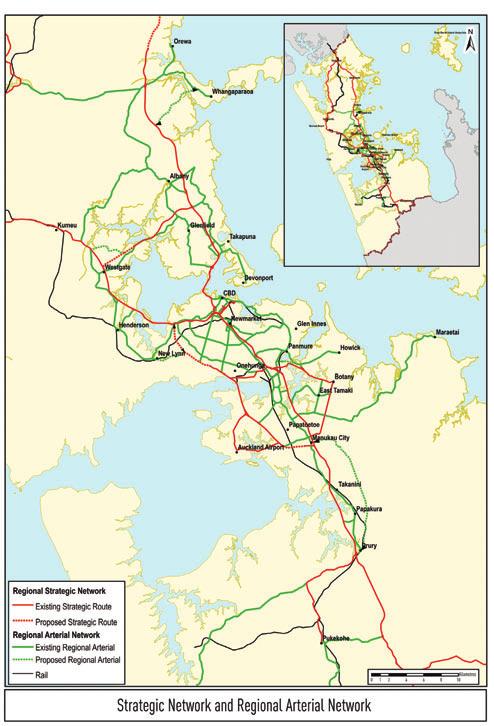
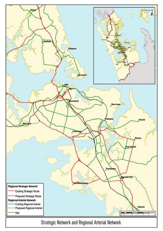
20 Figure 3: Proposed regional arterial road network 11
21 12
22 5 FUNCTIONAL CLASSIFICATION This section of the plan identifies the future functional classification of each section of the regional arterial network. This takes account of the following functions, and information on the demand for each function: General traffic: total daily volume in 2016 Passenger transport: peak-hour frequency in 2016 Cycling: links identified on the regional cycle network Freight: daily heavy commercial vehicle (HCV) movements in The classification also takes account of the relative importance of place, which relates to land uses adjacent to the regional arterials. The purpose of this classification is to consider where regional arterial roads pass sensitive land uses such as town centres or schools and the traffic on the road is likely to have a higher than normal affect on the adjacent area, For a summary of all areas defined as having a high place sensitivity, see Appendix H on page 60. The data for this classification has been sourced from the Auckland Regional Council s transport model (for general traffic and freight) and passenger transport model, the regional cycle network plan, counts of existing percentages of HCVs, and the knowledge of local TLAs in the case of place. A more detailed explanation of the definitions and methods used to determine the functional classification can be found in Appendix C and technical paper RARP-TP2. The resulting functional demand of the regional arterial network has been mapped and can be found in Appendix G. Following from this analysis, Table 4 below presents a summary of the role and future strategic direction for each section of the regional arterial network. The table also includes the short-term actions that are proposed for each section of the network, arising from the analysis in this plan. Table 4: Role and strategic direction of regional arterial roads Route Key roles Strategic direction Short-term actions Auckland City Great North Road (TLA boundary to Point Chevalier) Major bus route forming part of the QTN Passes through Avondale town centre Heavy traffic flows along Waterview Straight Route influenced by proposed SH20 Waterview extension Need to develop bus priority Integration with SH16 interchange management Integrate planning of bus priority measures on Great North Road with SH20 extension through Waterview Great North Road (Point Chevalier to Karangahape Road) Major bus route forming part of the QTN with bus lanes Accesses Western Springs/Zoo/MOTAT complex Intersects with Carrington Road, St Lukes Road, Bond Street, Newton Road and Ponsonby Road Continued emphasis on bus priority plus integration with SH16 interchange management Prepare plans showing how route will be managed to provide permanent bus lanes Integrate route planning with town centre development planning Wolverton Street Tiverton Road Maioro Street East-west route with increased role following SH20 Mt Roskill extension, including link between Maioro Street and Sandringham Road Increased traffic function Increased passenger transport role over time Complete implementation of route upgrading Carrington Road Mt Albert Road Mt Smart Road Mays Road Church Street Cross-city route Part of QTN west of Selwyn St, Onehunga Links growth centres and north-south corridors Accesses major employment areas, Unitec and Mt Smart Stadium Traffic flows to reduce west of Queenstown Rd as SH20 is extended westwards Use opportunity to increase passenger transport emphasis and integrate with intensification of town centres Prepare plans indicating how route will be managed in phase with the westward extension of SH20 and supporting town centre development objectives Part of regional cycle network 13
23 Route Key roles Strategic direction Short-term actions Auckland City (continued) St Lukes Road Balmoral Road Green Lane West and East Major east-west route intersecting with several north-south routes as well as the SH1 and SH16 motorways A general traffic route accessing the St Lukes regional shopping centre, Greenlane and Ascot Hospitals, Alexandra Park and the Showgrounds Some sections of the route have direct frontage access, while other sections have limited access Important cycle route with cycle facilities on some sections, but no route continuity Balance east-west capacity with north-south bus priorities at key intersections Seek to better manage frontage access over time and to make greater provision for cyclists Management of queuing at Greenlane interchange to prioritise east-west movement while integrating with SH1 Make decisions on development of Balmoral/ Greenlane/Manukau and Balmoral/Dominion intersections Where appropriate, incorporate access management, cycle facility improvement and integration with motorway management in corridor management planning Neilson Street Church Street Major freight route Accesses Penrose industrial area and Onehunga Along with SEART forms key linkage between SH1 and SH20 Upgrade to form strategic link between SH1 and SH20 (or replace with new route) Improve traffic conditions in vicinity of SH20 interchange while protecting Onehunga Mall from through traffic Determine future strategic route development needs including role of Neilson Street and freight priority measures Support future development of the Onehunga town centre Dominion Road (north of SH20) plus Ian McKinnon Drive Major bus route forming part of the QTN with bus lanes in place General traffic function will increase on extension of SH20 including an interchange at Dominion Road Serves a growth centre Further development as a major passenger transport route, serving route between Auckland Airport and the CBD May include improved access management and making better use of the supporting road network Resolution of future passenger transport role of Ian McKinnon Drive Finalise planning of the development of route as a major passenger transport facility Identify means of making better use of the supporting road network for shortdistance local trips to reduce pressure on Dominion Road Manukau Road Pah Road Queenstown Road General traffic route functioning as major access route to Auckland Airport Part of QTN north of Greenwoods Corner A focus on improving the quality and consistency of travel to Auckland Airport Bus priority at key intersections Finalise and implement measures for appropriate management of the corridor as a major route to the airport while recognising its important role in the bus network and land use development objectives Great South Road (north of Main Highway) Major bus route forming part of the QTN with north-bound bus lanes in place north of Greenlane Recently upgraded between Main Highway and Greenlane a section with high traffic demands Continued integration with changing land uses at Newmarket Further development of bus priorities north of Greenlane, particularly on approach to Newmarket Identify future bus priority needs, particularly on approach to Newmarket, including potential route protection needs Integrate route planning and development with land use development objectives and plans Great South Road (Main Highway to Saleyards Rd) Saleyards Road Walmsley Road Major freight route south of SH1 Penrose Interchange Serves major employment areas and Otahuhu growth area Management and development as a major freight route Consider capacity requirements from Church Street to Portage Road Identify and, as appropriate, implement freight priority measures Determine route development and route protection needs between Church Street and Portage Road 14 Atkinson Ave Mt Wellington Highway Part of QTN Serves major employment areas, Otahuhu and Sylvia Park shopping centre High traffic demands north of Sylvia Park Road General traffic emphasis with bus priority at intersections south of Sylvia Park Road Northern section forms part of AMETI Identify appropriate and feasible bus priority measures
24 Route Key roles Strategic direction Short-term actions Auckland City (continued) Ellerslie-Panmure Highway Part of QTN Serves high-density growth centres. Important general traffic route Passenger transport emphasis plus high traffic demands Integration with SH1 management at Penrose Interchange Determine an appropriate design for the corridor incorporating permanent bus priority measures Identify any route protection needs Integrate management west of Ellerslie with Penrose Interchange Sylvia Park Road and Portage Road East-west links between Mt Wellington Highway and Great South Road No change No actions identified Great South Road (TLA boundary to Otahuhu) North-South arterial paralleling the Southern Motorway Part of QTN Further development of higher passenger transport emphasis Further develop and implement bus priority measures Princes Street Route linking SH1 with Atkinson Ave, Otahuhu Management for general traffic movement Integrate with SH1 Interchange management and improvement South-eastern Highway High-capacity limited access route crossing the Tamaki River, intersecting with Carbine Road, crossing over Mt Wellington Highway, interchanging with SH1, intersecting with Great South Road and connecting with Church Street at O Rorke Road AMETI project includes duplicating the Pakuranga Bridge, upgrading Waipuna Road and Waipuna/SE Highway intersection and grade separating the Carbine Road intersection. Integration with management of SH1 in vicinity of the interchange. Refer to AMETI Integrate motorway ramps and the arterial route management Identify and where appropriate implement freight priority measures Lagoon Drive Panmure Bridge Part of QTN Limited capacity due to topography Connects to Panmure roundabout Part of AMETI project, which includes road and passenger transport network improvements Improved amenity and accessibility around Panmure roundabout Refer to AMETI Waipuna Road Link between South-eastern Highway and Mt Wellington Highway Part of AMETI, with important traffic function Refer to AMETI Jellicoe Rd Pilkington Road Apirana Ave (north to Merton Road) Part of QTN Access to Mt Wellington Quarry development and the University of Auckland s Tamaki campus Part of AMETI to be replaced by a new arterial route to Glen Innes Refer to AMETI Apirana Ave (north from Merton Rd) Kohimarama Road Kepa Road Ngapipi Road Tamaki Drive to The Strand Narrow general traffic route with poor alignment serving eastern suburbs of Auckland City Access to Glen Innes growth centre, schools and Eastridge shopping centre Tamaki Drive accesses the Port of Auckland container terminal and is a major scenic waterfront route Unclear pending decisions on eastern corridor north of Glen Innes Tamaki Drive place function will continue to influence design and management Resolve future of the corridor north of Glen Innes St Johns Road Remuera Road East-west route linking eastern suburbs with Newmarket and passing through the Remuera growth centre Part of QTN with bus priority measures under development Continuation of a higher passenger transport emphasis Integration with urban design through the Remuera centre Complete implementation of bus priority measures on Remuera Road Seek to give buses additional priority at approach to Newmarket 15
25 Route Key roles Strategic direction Short-term actions Auckland City (continued) Broadway, Newmarket Major bus route on QTN Main street of Newmarket retail area High traffic flows Continued management as a busy main street, with emphasis on passenger transport movement and pedestrian accessibility Potential development of an alternative route for buses and/or general traffic Finalise decision making on a possible alternative route bypassing Broadway Determine best means of efficiently catering for the major bus routes converging on Newmarket Gillies Avenue, Newmarket Alternative general traffic route through Newmarket with limited ability to cater for traffic growth Traffic pressures may increase on full implementation of ramp signalling Limited opportunity for change Integration with SH1 and Broadway management Integrate management with motorway on- and off-ramp management while catering for through arterial function Khyber Pass Newton Road Serves major employment areas and growth centres Interchanges with SH1 and SH16 ( half diamond interchanges). Khyber Pass is on QTN Passenger transport emphasis from Broadway to Park Road on implementation of the Central Connector, general traffic elsewhere Integration with motorway management Integrate management with motorway on- and off-ramp management while catering for through arterial function Implement Park Road/ Grafton Bridge section of Central Connector Fanshawe Street Sturdee Street/Lower Hobson Street Quay Street (to Lower Queen Street) Customs Street West Lower Queen Street Important traffic and passenger transport link between Northern Motorway (from North Shore) and the Auckland CBD Part of RTN Passenger transport emphasis Important pedestrian connections across route Form to be determined by Auckland City through Central Area Access Strategy Quay Street (west to Tinley Street) Provides link between SH16 and Port Important access to Port, but also eastern approach to CBD Form to be determined by Auckland City through Central Area Access Strategy Symonds Street Anzac Avenue Customs Street East Important passenger transport route to and within CBD forms part of Central Connector Passenger transport emphasis Important pedestrian connections across route Form to be determined by Auckland City through Central Area Access Strategy Karangahape Rd Pitt Street Vincent Street Mayoral Drive Albert Street Lower Albert Street Important passenger transport route to and within CBD Passenger transport emphasis Important pedestrian connections across and along route Form to be determined by Auckland City through Central Area Access Strategy Franklin District East Street Pukekohe East Road Mill Road Link between Southern Motorway (Bombay Interchange) and Pukekohe Important traffic route Emphasis on safety and access management SH22 Karaka Road Primary link between Southern Motorway (Drury Interchange) and Franklin District Important traffic route Emphasis on safety, access management and provision of sufficient capacity for identified growth SH22 Paerata Road Edinburgh Street Link to Pukekohe Important traffic route Transition to urban environment at Pukekohe Emphasis on safety and access management as far as southern termination of state highway Glenbrook Road Link to western Franklin, including Glenbrook and Waiuku Important traffic route Emphasis on safety and access management Manukau Road Buckland Road Link between Pukekohe and Tuakau Traffic route 16
26 Route Key roles Strategic direction Short-term actions Manukau City Great South Road from southern TLA boundary (Te Mahia) to northern boundary (Tamaki River) North-south arterial paralleling the Southern Motorway, serving several growth centres Has a main street function in several locations, particularly through Manurewa and Hunters Corner Part of QTN north from Manurewa Further development of higher passenger transport emphasis Continued recognition of the importance of place in Manurewa and elsewhere Further develop and implement bus priority measures north from Manurewa Integrate planning with measures for supporting pedestrian activity and economic vitality of the town centres Harris Road Springs Road East Tamaki Road (south to Ormiston Road) Major freight route accessing a major employment area Part of QTN Continuation of management and development as a major freight and general traffic route Increased passenger transport role Identify and implement appropriate freight priority and bus/hov priority measures East Tamaki Road (west from Ormiston Road) East Tamaki Road has high traffic volumes, accesses schools and passes through Otara Ormiston Road links N-S arterial routes and Flat Bush growth centre Management as a general traffic route supporting adjacent land uses ( place ) in the Otara area Determine corridor management policies and plans supporting efficient traffic movement, pedestrian safety and the Otara town centre Highbrook Drive Allens Road Smales Road New route accessing the Highbrook employment area, connecting to Harris Road and Te Irirangi Drive at the eastern end, and a new partial interchange with SH1 at the western end General traffic and freight emphasis No action identified Ormiston Road Sandstone Road Whitford Maraetai Road Link between strategic network at Manukau and Beachlands/Maraetai area General traffic emphasis Emphasis on safety and access management Pakuranga Road Multi-lane arterial accessing a large residential area, the Highland Park and Pakuranga growth centres, Lloyd Elsmore Park and schools Part of QTN Connects to Pakuranga motorway bridge via Reeves Road and Ti Rakau Drive Increased passenger transport focus Upgraded connection to Pakuranga Motorway via Reeves Road proposed as part of AMETI project Identify and implement further bus priority measures Refer to AMETI for southern end of corridor Ti Rakau Drive Major divided arterial accessing Botany Downs shopping centre, Pakuranga growth centre and a major employment area Part of QTN with a substantial increase in bus numbers projected in future AMETI project proposes a major upgrading including addition of bus lanes and upgrading of Reeves Road/Pakuranga motorway intersection Refer to AMETI Freight route with high general traffic volumes Pakuranga Motorway High capacity limited access route crossing the Tamaki River, connecting Ti Rakau Drive with South-eastern Highway AMETI project includes duplicating the Pakuranga bridge and providing grade separation at Ti Rakau Drive/Reeves Road Refer to AMETI Te Irirangi Drive Divided North-south route through East Tamaki Corridor extending from Ti Rakau Drive (Botany Downs Centre) to Great South Road just north of Manukau CBD and interchanging with SH1 (north-facing ramps) Consideration being given to long term proposal for RTN Maintain arterial traffic function Supports development of Flat Bush higherdensity development area and accesses Manukau City Centre Nesdale Avenue Liverpool Street Cavendish Drive Cross-city general traffic and freight route just north of Manukau CBD connecting with SH20 extension to west and Te Irirangi Road to east Once completed, manage as a freight route No action identified Under construction 17
27 Route Key roles Strategic direction Short-term actions Manukau City (continued) Massey Road Cross-city route from Massey Road SH20 interchange to TLA boundary Most of route is on QTN Increased passenger transport focus Identify and implement appropriate bus priority measures Redoubt Road Mill Road Route between Manukau CBD and Flatbush and between Manukau CBD and proposed upgrade of Mill Road route through Papakura District to Drury Planning, design, designation, land acquisition and staged implementation of route Completion of investigation into concept and alignment followed by route protection Important passenger transport route to Flatbush North Shore City Albany Highway Glenfield Road Onewa Road to SH1 North-south route serving North Shore City west of SH1, accessing the Albany subregional centre, Albany industrial area, Glenfield and Birkenhead town centres North of Sunset Road route serves a rapidly developing area, a number of schools and Massey University Limited access South of Sunset Road fronted by predominantly residential development with direct frontage access Greater passenger transport emphasis along Glenfield Road Significant traffic pressures between Wairau Road and Upper Harbour Motorway Important cycle route in the vicinity of Albany schools Prepare plans and develop a programme for accommodating bus priority measures on Glenfield Road Investigate future development and management of Glenfield Road, north Wairau Road and Albany Highway Part of the QTN with particularly high bus movements on Onewa Road, which has an east-bound transit lane Wairau Road Taharoto Road to Northcote Road Cross-city route linking the major northsouth arterial routes in North Shore City, providing access to the Wairau Valley and Smales Farm employment areas and linking to SH1 at the Tristram and Northcote Interchanges. Also accesses North Shore Hospital and secondary schools High traffic flows and part of QTN, serving Smales Farm busway station High traffic demands and changing uses along Wairau Road Integration with SH1 management Passenger transport emphasis on routes to/from busway station Significant place pressures adjacent to business park, hospital and schools Determine the appropriate traffic management and route development policies and priorities for Wairau Road Continue implementation of bus priority measures Integrate arterial network management with Tristram and Northcote motorway interchange management East Coast Road (south of Oteha Valley Road) Forrest Hill Road Taharoto Road Anzac Street Barry s Point Road North-south route serving North Shore east of SH1, providing access to city s eastern suburbs, Smales Farm and Takapuna On QTN Transit lane recently constructed along Forrest Hill Road Balance high and increasing traffic demands with increasing emphasis on bus/hov Integration with SH1 interchange management Develop policies and plans for implementing bus/t3 priority measures on East Coast Road while accommodating increasing traffic demands, particularly north Constellation Drive Access to SH1 at Constellation, Greville, Tristram, Northcote and Esmonde Interchanges TDM emphasis for land uses on Taharoto Road Oteha Valley Road Limited access east-west route from Albany Expressway (SH17) to East Coast Road Accesses Albany Centre and North Harbour Stadium, SH1, Albany Park and Ride, and Browns Bay Long Bay areas Protection of transport functions while accommodating growth Develop a strategy for accommodating traffic growth while providing appropriate bus priority measures east of SH1 Part of the QTN east of SH1 with important passenger transport access role to busway station. 18
28 Route Key roles Strategic direction Short-term actions North Shore City (continued) SH17 (south from TLA boundary Albany Expressway) North-south route from Rodney to Northern Motorway (at Greville Interchange), serving Albany centre and Massey campus Albany Expressway on QTN north of Bush Road Increasing passenger transport emphasis on access to Albany centre Significant capacity challenges at Greville Interchange Identify appropriate bus priority measures Firm up plans for upgrading and managing Greville Interchange Passes through Albany village Retain importance of Albany village Greville Road East-west route from motorway to East Coast Road Primarily traffic route, providing access to motorway Esmonde Road and Akoranga Drive Arterials east and west of SH1 accessing Takapuna Centre, Lake Road, Devonport and AUT University s Akoranga campus Esmonde Road and interchange recently upgraded. Now linked with Akoranga Drive in both directions Possible increased network role for Akoranga Drive Determine future role(s) of Akoranga Drive, taking an additional harbour crossing into account Transit lanes on Akoranga Drive Lake Road (Esmonde Road to Calliope Road) Arterial serving Devonport peninsula, including access to ferries and naval base Development capacity of peninsula is closely aligned to person-carrying capacity of Lake Road Maximise safety and efficiency of route, with attention to needs of key adjacent uses and pedestrians and cyclists Northcote Road (Akoranga to Taharoto) Highly trafficked route accessing Onewa Domain, Smales Farm, North Shore Hospital and Milford Integration with SH1 management Urban design and pedestrian improvements west of SH1 Integrate arterial network and Northcote Motorway interchange management Integrating route planning and development with pedestrian and amenity improvements Constellation Drive Link between East Coast Rd and Upper Harbour Highway (including interchange with Northern Motorway) Transit lanes have been implemented in both directions Ensure passenger transport emphasis is retained Part of QTN, with important passenger transport access to Constellation busway station Tristram Avenue Link between Wairau Valley and Northern Motorway Also, east-west route with link across city to East Coast Road Important traffic and freight function Seek to improve separation between motorway and east-west traffic Papakura District Great South Road from Drury Interchange to northern TLA boundary North-south arterial paralleling the Southern Motorway serving the Papakura growth centre Important arterial traffic function but importance of place in Papakura and elsewhere Integrate planning with measures for supporting pedestrian activity and economic vitality of the town centres Mill Road/Cosgrove Road Route to be upgraded between Manukau and Drury Planning, design, designation, land acquisition and staged implementation of route Completion of investigation into concept and alignment followed by route protection Proposed Redoubt Road Mill Road corridor Proposed new arterial route to east of SH1 from Manukau Centre to Drury. Involves the upgrading of Redoubt Road and Mill Road and the extension of Mill Road south along a new corridor passing east of Papakura centre and ending at Drury Planning, design, designation, land acquisition and staged implementation of route Completion of investigation into concept and alignment followed by route protection Beach Road Route between Southern Motorway and Papakura town centre Important traffic function, plus developing passenger transport function to link Hingaia with Papakura 19
29 Route Key roles Strategic direction Short-term actions Rodney District Coatesville Riverhead Highway Link between SH17 and SH16 Traffic function Emphasis on safety and access management Kahikatea Flat Road Traffic function Emphasis on safety and access management Pine Valley Road Link between SH17 and Kahikatea Flat Road Traffic function Emphasis on safety and access management SH1 Hibiscus Coast Highway Link between Northern Motorway at Silverdale interchange and Orewa Strategic function will decrease following completion of ALPURT, but increasing access function and passenger transport functions Continue to improve Hibiscus Coast Highway to respond to changes in demands, with bus priority Whangaparaoa Road Sole route linking Whangaparaoa Peninsula with Hibiscus Coast Highway Dependence of Peninsula on route will decrease when PENLINK is implemented Progress PENLINK Confirm relationship between PENLINK and upgrading of Whangaparaoa Road west of Red Beach Road PENLINK Proposed regional arterial route Traffic function Project to be progressed, to reduce role of Whangaparaoa Road and Hibiscus Coast Highway SH17 (north from TLA boundary) Link between North Shore and Silverdale Primarily traffic function Emphasis on safety and access management Waitakere City Hobsonville Road Arterial link between Upper Harbour Bridge and Massey North/Westgate, Waitakere City Provides access to the planned Hobsonville peninsula and village high-density, mixed use developments Traffic flow to reduce on completion of SH18 Motorway Part of the QTN network Increased passenger transport emphasis after SH18 Motorway completion Greater role for route to serve adjacent development along QTN route, following completion of SH18 Motorway Prepare plans showing staged development of route on completion of SH18 Motorway to provide appropriate bus priority measures and cater for cyclists and support planned Hobsonville corridor land use development Important cycle link across Upper Harbour Great North Road Sel Peacock Drive Edmonton Road Great North Road Rata Street Ash Street Great North Road (to TLA boundary) Links Massey North, Henderson, New Lynn and Avondale high-density growth centres Is part of QTN on Great North Road from Edmonton Road, Henderson to Rata Street, New Lynn and on Great North Road from intersection with Ash Street to TLA boundary An important freight route Carries high traffic flows in places particularly between West Coast Road and Rata Street Adjacent land uses currently have direct frontage access over much of the route Great North Road in Waitakere City is a growth corridor with a passenger transport emphasis Corridor passes through or supports several town centres where higher-density, mixed-use is planned Prepare policies and plans for the phased implementation of bus priority measures along the route supporting its role as a growth corridor and major bus route Identify measures for supporting freight movement where part of the regional freight network 20
30 Route Key roles Strategic direction Short-term actions Waitakere City (continued) Lincoln Road A growth corridor with high traffic volumes running from Great North Road to SH16 (North-western Motorway) An important freight route Part of the QTN Provides both through traffic and local access functions Access to Waitakere Hospital More passenger transport and cycle emphasis and closer integration with SH16 management Improve flow at SH16 junction Finalise policies and plans for development of route and adjacent land uses incorporating bus/hov priority measures, integrating management with Lincoln Road Interchange, and requiring/ encouraging travel plans for major land uses Clark Street (TLA boundary to New Lynn) East-west route with increased role following SH20 Mount Roskill extension Elimination of Clark/Rankine/Totara roundabout on placement of rail line in trench through New Lynn Increased traffic function Increased passenger transport role over time Integration with intensification of New Lynn town centre Complete implementation of route upgrading Integrate improvement and extension of Clark Street with New Lynn town centre development Edmonton Road Te Atatu Road Links Henderson with the North-western Motorway High traffic volumes Part of QTN (Te Atatu Road) More bus/hov emphasis on Te Atatu Road and closer integration with SH16 management Identify measures for providing bus priority on Te Atatu Road Integrate with Te Atatu interchange management Brigham Creek Road Link from Hobsonville Road to SH16 Traffic function Emphasis on safety and access management SH16 (Westgate to Brigham Creek) Don Buck Road Triangle Road Strategic function north of Massey North to reduce following completion of SH16 Extension Traffic function Emphasis on safety and access management (north of Massey North) 21
31 6 PRIORITISATION This section of the plan builds on the functional classification of the previous section and identifies priorities for action on the basis of a deficiency assessment. ARTA is aware that considerable improvements to the regional arterial network will be necessary in the near future. As the cost of improving the network is forecast to exceed available funding, it is especially important that the most critical deficiencies are identified and addressed first. It is also noted that there are situations where actions on parallel routes may relieve pressure on an arterial. To achieve this, ARTA has created a prioritisation matrix which is designed to take into consideration the functional requirements and future strategic role of each section of road (from Section 5), and an assessment of how well those roads are likely to perform their strategic function in the future. This analysis has been used to identify the relative priority of network deficiencies, and the need for further studies, which in most cases will take the form of corridor management plans. function (e.g. significant congestion and no bus priority measures). Links which have been identified as having high deficiencies that reduce the function of an arterial (according to its classification) are set out in Appendix I. In addition to mapping the key areas for attention by function, the priority 1 and 2 scores have been combined along each segment in the table on page 67 (Appendix 1). This analysis suggests that the following routes are the highest priority for further attention, including the development of corridor management plans 9 : Albany Highway: Upper Harbour Highway to Wairau Road Wairau Road: Target Road to Tristram Avenue Lincoln Road: Te Pai Place to SH16 Interchange Te Atatu Road: Edmonton Road to SH16 Great North Road: Blockhouse Bay Road to SH Performance Assessment The performance assessment used the following criteria for each function: General traffic: level of service in the weekday morning peak period in 2016 Passenger transport: level of service in the weekday morning peak period in 2016 Cycling: the extent of cycle facilities present on the regional cycle network Wolverton Street Broadway: Khyber Pass Road to Manukau Road Khyber Pass Road: Symonds Street to Broadway Ellerslie Panmure Highway: Panmure Roundabout to Great South Road Great South Road: Church Street to Portage Road Pakuranga Road: Panmure Bridge to Ti Rakau Drive South-eastern Highway: Waipuna Road to Ti Rakau Drive Freight: level of service in the weekday inter-peak period in 2016 Safety: volume of traffic per day in 2016 against the present day accident rate per 100 million vehicle kilometres travelled Place: the relative sensitivity of the link and place tension. The information used in this assessment came from a number of sources, including the ART model, crash data and TLA knowledge. Further information on the definitions and methodology used can be found in Appendix C and Technical Paper Priority Assessment A priority assessment has been undertaken in order to establish priorities for action. This involved a comparative analysis of the functions and the deficiencies for each road, and the allocation of a series of priority scores 8. A priority 1 or 2 score indicates a high priority for further investigation and/or action. In order to be classified as priority 1 or 2, the road must demonstrate that it has a high functionality for that category (e.g. passenger transport frequency) and a high deficiency in providing for that Church Street: Neilson Street to Great South Road Neilson Street: SH20 Interchange to Onehunga Mall Ti Rakau Drive: Harris Road to Pakuranga Road Great South Road: Redoubt Road to Te Irirangi Drive. It is important to note that this is not an exhaustive list of all routes which require attention. There are many other sections of road which fall just outside the threshold used to determine the listed routes. In some cases, projects are being proposed to address the issues identified. For example, the AMETI project is proposed to address issues along Ti Rakau Drive, Pakuranga Road and the crossings of the Tamaki River, but these works are not yet committed. In other cases, existing problems may have been resolved by projects which have been assumed to be completed by The list does not indicate that road building or widening is required at all of the above locations. Rather it indicates that there are a variety of problems in these areas. Solutions may focus on achieving greater efficiency, rather than providing greater capacity. Roads within the Auckland CBD have not been included within this list of highest 8 An overview of this analysis including the data used and priority scores (from 1-4) can be found in Technical Paper RARP-TP3. 9 It is assumed that arterials that appear with multiple deficiencies within the CBD will be addressed within the Central Area Access Strategy (CAAS). 22
32 priority roads. It is expected that issues within the CBD will be addressed in accordance with Auckland City Council s Central Area Access Strategy. Projects which have come about as a result of a corridor management plan for a route identified as having a high priority from this analysis can be expected to be given a high priority in the funding system. It is important to note, however, that projects put forward for funding which are not on the regional arterial network or are not considered to be the highest RARP priority projects will still be assessed on their merits for national share funding. Figure 4: Multiple priority analysis Regional arterials that have deficiencies related to more than one road function. This multiple deficiency indicates a need for further investigation, usually in the form of a CMP. 23
33 7 ARTA POLICIES Previous sections of this Regional Arterial Road Plan have described the regional arterial network and its current deficiencies, and identified the priority issues that need to be addressed. This section sets out ARTA s policies for the regional arterial road network. These policies provide a framework that will guide ARTA s planning and funding functions, as they relate to regional arterials in the future. The policy framework recognises that the responsibility for ongoing development, operations and management of the regional arterial network lies with the territorial authorities. Accordingly, ARTA s role in relation to operational matters is focused on providing regional coordination, and encouraging road controlling authorities to adopt a consistent approach to the future development and management of regional arterials. ARTA s statutory role in relation to regional arterials relates to funding and project prioritisation. In these areas, the policy framework is more specific, and focuses on ensuring that regional transport funding is directed towards projects that will deliver the most effective solutions. 1. ARTA will encourage territorial authorities to incorporate the regional arterial road network identified in this plan into district plan road hierarchies. 2. ARTA will work with territorial authorities to develop district plan objectives, policies and rules that reflect the functional classifications outlined in this plan. 3. ARTA will recommend to the Auckland Land Transport Committee that the regional arterial road network described in this plan be included in the next review of the RLTS. 4. ARTA will encourage road controlling authorities to prepare corridor management plans for regional arterials, giving priority to those that have been identified as having a high priority for attention in this plan. Corridor management plans should take account of the guidelines in Section 8 on page 25 of this plan. 5. ARTA will work with territorial authorities and the NZTA to ensure that there is sufficient coordination between all parties to enable effective integration of state highways with local roads. 6. ARTA will encourage road controlling authorities to implement the guidelines outlined in Section 8 of this plan, to improve the effectiveness, safety and management of the regional arterial network, including actions aimed at: a. Making better use of the existing road space through giving greater priority for buses and high occupancy vehicles and placing emphasis on moving freight efficiently and safely, where appropriate b. Supporting land use intensification at identified high-density centres and along growth corridors c. Making greater use of access management plans d. Better meeting the needs of pedestrians and cyclists e. Encouraging the development and implementation of engineering measures to improve road safety f. Encouraging the use of technology and advanced traffic management systems. 7. In determining the relative priority for funding of projects on regional arterials, ARTA will take account of the functional classifications, deficiencies and priorities identified in this plan, and the content of corridor management plans. 8. ARTA will give priority to funding for projects designed to efficiently allocate regional arterial road space to meet both strategic and local community objectives, and give priority to the movement of people and freight over the movement of single occupant cars, particularly during peak periods. 9. ARTA will generally accord a high priority to projects that have come about as a result of a corridor management plan that is given a high priority in this plan. 10. ARTA will encourage the NZTA to increase the financial assistance rate for regional arterials, to recognise the important role that regional arterial roads fulfil within the wider transport network, and to encourage road controlling authorities to bring forward appropriate projects. 24
34 8 CORRIDOR MANAGEMENT PLAN GUIDELINES The main tool to consider what improvements to regional arterial roads are most appropriate is the development of a series of corridor management plans (CMPs). ARTA s policy is to encourage territorial authorities to prepare CMPs for all regional arterial routes, giving priority to those routes and issues identified as having high priority in this plan, and subsequently put forward schemes for inclusion in the Auckland Regional Land Transport Programme. This section sets out guidelines to assist with the preparation of CMPs. The guidelines are aimed at assisting decision making on the allocation of scarce regional arterial road space among different and competing demands to improve its efficiency and effectiveness. They include measures that give priority to buses, high occupancy vehicles, freight traffic, and bicycles. Also included are guidelines relating to the control of parking on arterials, to pedestrian facilities and to the identification and treatment of urban design elements. To emphasise the importance that ARTA places on CMPs and to give direction on the outcomes ARTA is seeking, ARTA policies are included in the guidelines. Appendix J: Corridor Management Plan Techniques on page 70 of this plan describes various techniques that can be applied to improve the performance of the regional arterial network, plus associated actions that can be taken to improve the effectiveness of each measure. can reduce the number of short-distance local trips using the arterial, enabling it to better meet the needs of longer-distance through traffic. Principles for Corridor Management Plans A corridor management plan seeks to establish the existing and future operation of an entire corridor, through an integrated assessment of transport routes and land uses within the corridor. A corridor management plan needs to take the Regional Arterial Road Plan and other documents into account in order to fully understand the intended transport and land use roles. In particular, corridor management plans need a regional perspective on the intended future roles of each route. These are described in Table 4 on page 13. Corridor management plans should ensure consistency of treatment of arterials crossing local authority boundaries. To better manage arterial roads for the movement of people, goods and services, it is essential that a range of low-cost options be considered to improve travel times, reliability and capacity (where capacity is measured in terms of people and goods rather than vehicles). The actions required should be agreed as part of a corridor management plan (or an access management plan), and need to address: 8.1 Definitions and Principles Corridors Corridors are transportation pathways that provide for the movement of people and goods between and within activity centres. A corridor encompasses single or multiple transportation routes or facilities such as a motorway, arterial road(s), public transport (bus or rail), cycleway and pedestrian facilities, the adjacent land uses and the connecting network of streets (and rail lines). Corridor management plans should therefore incorporate the full extent of these related corridor activities. Traffic signal operations and optimisation Carriageway use, markings and signage. Optimising the road space use includes appropriate median treatment (width, flush/ raised/landscaped), and peak-time lane management including dynamic management, access control, intersection treatments etc. Route signage should be comprehensive, covering all key intersections and regional arterial routes. Integration with adjacent land uses Integration with adjacent rail (as it relates to freight and the RTN) The physical width of a corridor can vary depending on the adjacent land uses, road network layout and topography. As a general guide, a 400-metre-wide corridor enables most nearby land uses to be included, while an 800-metre-wide corridor allows all locations within a five-minute-walking distance of the corridor to be included. In some instances it may be appropriate to develop a management plan for an area that includes two or three corridors that are strongly inter-related. The road transport network in the vicinity of the arterial plays an important role and the corridor should extend sufficiently far to enable the supporting network to be incorporated in the corridor access and management plans. Measures to improve the effectiveness of an arterial can affect intersecting and adjacent streets (and rail lines). Improving the connectivity and walkability of the local network Consistency with urban design plans Integration with the strategic objectives of the region and the city or district concerned Parking enforcement enforcement of clearways and bus/transit lanes is an essential element in traffic management on arterials Travel Demand Management (TDM) measures forming part of school and workplace travel plans and neighbourhood accessibility plans. Corridor management plans should be prepared for the entire regional arterial network. However, this will take some time to achieve. Accordingly, it is necessary to prioritise resources to those corridors with the greatest need. Section 6 on page 22 of this plan indicates those parts of the regional arterial network which should be 25
35 prioritised first. ARTA is seeking applications for projects aimed at dealing with identified priorities and issues on the regional arterial road network and consequently encourages territorial authorities to give high priority to management plans for those corridors which should be prioritised first. The following points are noted: 1. The issues identified in this plan are at a high level, over relatively long sections of road. The roads have been split into sections which have some similarities, but inevitably there are differences within any given section, and the deficiencies may only relate to parts of the defined sections. 2. As the underlying analysis has been high level, it is likely that some problem areas or deficiencies have not been identified. Consequently ARTA is prepared to consider alternative CMP priorities if sufficient evidence is provided. 8.2 Potential Components for Corridor Management Plans Access Management Plans ARTA policy The territorial authorities are encouraged to prepare arterial access management plans as part of the preparation of corridor management plans, or an appropriate alternative process. ARTA will prepare guidelines on access management policy in consultation with the territorial authorities. Access management is a systematic approach to the management of access to the road network. It seeks to manage access to roads in accordance with their role in the network, while recognising the needs of the adjacent land uses. The aim is to achieve an appropriate balance between catering for through movement of people and goods and providing for property access. Roads with limited access are better able to move people and goods safely and efficiently. However, several arterials or sections of arterials, particularly in the older parts of the region, have competing roles which require good interaction between the arterial and the fronting land uses. Most arterials in the region are treated as an all for one facility, providing for through traffic, direct property access, and turn movements at intersections, all from what is typically a single carriageway. That requires through traffic to negotiate vehicles entering and leaving properties from both sides in mid-block sections, in addition to vehicles turning into or out of the arterial at numerous and often closely spaced intersections. To cater for turning traffic movements, a flush median can be added in the centre of the arterial road. Flush medians of adequate width can also accommodate pedestrian refuges. However, road space is an expensive commodity for which there are often competing requirements. The use of road space for flush medians to allow the segregation of right turning traffic must be carefully weighed against other objectives a route may need to achieve, such as public transport priority or other priority lanes. It is important to avoid to the greatest extent possible, the down-rating of the transport function of the arterial network resulting from the introduction of additional access demands in inappropriate ways. Research undertaken in the United States shows a clear correlation between the number of access points on a road and the crash rate. The indices suggest that an increase from approximately six to 12 driveways per kilometre, increases the crash rates by about 30% to 40%. Reducing the number of conflicting vehicle movements, particularly right-turning movements, generated by fronting development and intersecting side roads on regional arterials improves the efficiency and safety of arterial roads. Raised medians, also referred to as solid or kerbed medians, provide for more efficient traffic control on major arterials and provide greater safety benefits than flush medians. Raised medians control right-turn movements into and out of driveways and minor intersections. Provided they are of sufficient width, they can also shelter pedestrians and accommodate street trees or other forms of planting. Gaps can be provided in wide medians to permit vehicles to make a u-turn prior to the next intersection. Raised medians can work well with roundabouts as traffic turning out of a driveway or intersection can use the next downstream roundabout to make a u-turn manoeuvre. The main disadvantages of raised medians are that they increase travel distances and add to turning traffic at controlled intersections. They may also result in the diversion of some traffic onto local streets. 26
36 8.2.2 Bus Lanes ARTA policy Description Permitted users Design Regional arterial examples Guideline ARTA supports and encourages the use of bus lanes on all major public transport routes, especially on QTNs, in locations where bus lanes would offer a relative advantage over general traffic and improve the reliability of bus services. Bus lanes are clearly marked lanes, usually kerbside, with signs stating Bus Lane which give the hours of operation. Buses are defined as large public service vehicles. Bus lanes are usually marked as clearways, but clearways are not required by the current road transport user rules. In the Auckland region, bus lanes are currently restricted to buses, motorcycles, traffic enforcement and emergency vehicles. Bus lanes may also be used by cyclists unless specifically excluded by a sign. During the hours of operation, other vehicles can only use bus lanes for a distance of up to 50 metres when turning left, merging, entering or exiting a side road or driveway. Parking is not permitted in bus lanes during the hours of operation. Bus lanes should, where possible, be sufficiently wide to permit buses to pass cyclists within the lane. This typically requires a desirable minimum width of 4.3 metres (Austroads standard). The alternative is to provide narrow lanes with a width of approximately 3.0 metres. Narrow lanes make it clear that a bus overtaking a cyclist must move into the adjacent lane. Widths between 3 and 4 metres are not favoured. Indenting bus bays, where width is available, can improve the operation of bus lanes by permitting buses to pass a bus stopped at a bus stop. This can be particularly beneficial on routes with a mixture of express and local services. Dominion Road north of Balmoral Road, Great North Road east of Point Chevalier and Great South Road north of Greenlane in Auckland City Sections of Great South Road, Manukau City Bus lanes should be considered in situations where the arterial serves a major destination where the policy is to encourage access by public transport, or serves a major public transport corridor, and 1. The section of arterial is congested and the bus lane would offer a time advantage 2. The section of arterial concerned is congested and the bus lane offers a time advantage to buses 3. The section of arterial concerned meets the minimum bus frequency criteria, namely: Is on the QTN and carries at least 12 buses per hour in the direction concerned in the design year, or Currently has on-street parking during the time period concerned and carries at least 15 buses per hour in the direction concerned in the design year, or The bus lane will carry as many people as the adjacent lane for the design scenario. Allowing carpools/vanpools into the lane will reduce the benefits to buses to an unacceptable extent, or create safety risks that cannot be adequately mitigated. ARTA also supports the provision of bus facilities along corridors with lower frequencies than those indicated above, where this can be justified on the basis of future demand or anticipated traffic patterns. For example, bus priority facilities are proposed by Waitakere City Council along Hobsonville Road as soon as the SH18 Hobsonville deviation is completed, in order to establish the right message in the Hobsonville development areas, before traffic flows build up. 27
37 8.2.3 Transit and HOV Lanes ARTA policy Description Permitted users Design Regional arterial examples ARTA supports and encourages the use of transit lanes on arterial roads, especially in locations where it would be difficult to justify the use of bus lanes due to relatively low bus numbers, or in locations where the transit lane links with an HOV lane. Transit lanes are clearly marked traffic lanes with signs stating Transit Lane which include the times of operation. Transit lanes differ from bus lanes in that they may also be used by high occupancy vehicles (HOVs), i.e. carpools and vanpools. HOV lanes generally apply to motorway corridors including metered on-ramps and hence can only be used by vehicles permitted to access motorways. There are no HOV lanes in Auckland at present. Transit lanes are lanes reserved for buses, HOVs and motorcycles. Transit lanes may be used by cyclists unless specifically excluded by a sign. Traffic enforcement and emergency vehicles may use transit lanes. In North Shore City, taxis are also permitted access (regardless of the number of passengers). In the Auckland region, HOVs are defined as vehicles carrying three or more people and the transit lanes are referred to as T3 lanes. Parking is not permitted in transit lanes during the hours of operation. HOV lanes are exclusively reserved for high occupancy vehicles and buses (plus traffic enforcement and emergency vehicles). They cannot be used by bicycles, motorcycles or scooters, or by taxis with less than the permitted minimum number of passengers. Transit lanes should be sufficiently wide to allow cyclists and motorists to travel side by side in the lane, indicating a desirable minimum width of approximately 4.3 metres. North Shore City specifies a minimum width of 4.5 metres where the transit lane accommodates cyclists (e.g. Constellation Drive) and 3.8 metres where it does not (e.g. Akoranga Drive). The Onewa Road transit lane has been in operation since Transit lanes were introduced on Constellation Drive east of the Northern Motorway in The Northern Busway is designed to eventually accommodate both buses and HOVs (once sufficient motorway capacity is available south of the Harbour Bridge). The use of transit lanes at some approaches to the Northern Motorway is consistent with that concept. However, motorcycles, bicycles and taxis with less than three occupants will not be able to use the Northern Busway or motorway HOV lanes in general. Guideline The arterial (segment) leads to an HOV facility in a motorway corridor, or is in a corridor with low bus numbers where the policy is to encourage higher vehicle occupancies, and carries at least 150* HOVs per hour, or The arterial does not/will not carry enough buses to justify a bus lane, but is still an important bus route with longterm potential and carries the bus + HOV equivalent of 15 buses or 150* HOVs per hour, and There is sufficient lane width available for buses, HOVs and bicycles, or bus stops can be recessed and bicycles can be accommodated elsewhere, e.g. shared footpath, and there is adequate width for a shared bus/hov lane, and Adequate enforcement can be ensured. Transit/T3 lanes can be more difficult to enforce than bus lanes. * For decision-making purposes 10 HOVs are equivalent to 1 bus 28
38 8.2.4 Cycle Lanes ARTA policy Description Permitted users ARTA supports and encourages the use of cycle lanes in appropriate locations. The safety and interests of cyclists must be considered on all regional arterial improvement schemes. A kerbside cycle lane is a lane marked exclusively for cycle use using an edge line plus cycle symbols at regular intervals. Cycle lanes may be also located next to on-road parking. All cyclists. Car parking is not permitted on cycle lanes. Design In designing cycling facilities reference should be made to Austroads Guide to Traffic Engineering Practice Part 14 Bicycles (AP-11.14/99) and to the New Zealand Supplement to the Austroads Guide to Traffic Engineering Practice Part 14, NZTA (formerly Transit NZ), March 2005 Examples Esmonde Road, Taharoto Road, Mt Albert Road, Greenlane. Guideline A kerbside cycle lane is the preferred solution for on-road cycle facilities, although it may not provide sufficient protection for inexperienced cyclists. Kerbside cycle lanes apply at all times. A cycle lane next to parking may be an appropriate solution where sufficient carriageway width is available and parking restrictions are not acceptable. Where there is insufficient width for a kerbside cycle lane, a wide kerbside lane for general traffic would allow cyclists and motorists to travel alongside each other within the lane. This solution is also appropriate on roads with clearway operation and kerbside parking permitted outside the peak period(s). NZTA s Cycle Network and Route Planning Guide, 2004 states that Wherever possible, arterial roads should be planned with cycle facilities from the outset or retrofitted to bring them up to best practice standard. The region s indicative regional cycle network indicates an expectation that several existing arterial routes including regional arterials will be adapted/modified to provide cycle lanes. The ability to accommodate these desires and expectations will be strongly influenced by the competing pressures for existing road space and existing road reserve width. It may be necessary to accept that some sections of the regional arterial network will not be able to provide dedicated facilities for cyclists and an alternative cycle route may be required. It should be noted that bus and transit lanes can potentially accommodate cyclists Clearways ARTA policy Description Permitted users Design Examples ARTA supports and encourages the use of clearways on arterial routes where bus or transit lanes are not appropriate to facilitate the efficient and safe movement of people and goods. Clearways can be particularly important on routes to strategically important destinations such as ports and airports, and on the major freight routes. A clearway is a length of carriageway defined by clearway signs along which the parking or standing of vehicles is prohibited during the specified time period(s). Generally, clearways operate during the peak periods for a particular direction, to provide increased road capacity through removal of kerbside parking. Clearway restrictions usually apply for a period of two hours, but this can vary depending on the location. No stopping at all times (NSAAT) controls are used along some lengths of arterials where traffic flows are high throughout the day. They are also used at the approaches to, and departures from, major intersections to improve capacity, and at locations where kerbside parking is a safety hazard. The latter includes sections of road where visibility is limited, turning radii at intersections etc. NSAAT controls are demarcated by a broken yellow line. NSAAT can be thought of as a permanent clearway. Applies to all vehicles. Refer to the NZ Manual of Traffic Signs and Markings (MOTSAM). Numerous, e.g. Manukau Road north of Greenlane, Ash Street. Guideline Clearways and, ideally, no stopping at all times controls, can be an appropriate measure on roads where the emphasis is on the efficient and safe movement of freight and general traffic. They benefit all traffic by reducing delays and increasing capacity. Clearways do not give any advantages to buses or other priority vehicles over the other vehicles in the traffic stream. Hence they may not be appropriate on arterial roads where, generally, priority should be given to the movement of people as distinct from the movement of vehicles. 29
39 8.2.6 Freight Priority Measures This table is limited to describing potential techniques for providing priority to freight vehicles. Further work is required to develop guidelines on appropriate solutions and to identify the strategic freight network. ARTA policy Description Design Potential techniques ARTA supports and encourages the use of freight priority measures on the regional freight network in locations where there is a need to improve the reliability of freight and where the advantages conferred to freight movement over general traffic justify their implementation. Measures for giving priority to heavy commercial vehicles (HCVs). In principle this could be broadened to measures to give priority to the movement of goods by road. The design of freight routes should accommodate the representative vehicles (the design vehicles) using the routes. Appropriate signage will also be required to identify the strategic freight network. Dedicated HCV lanes. Creating freight bypass lanes on metered on-ramps allowing freight vehicles to bypass the on-ramp queue during the operation of ramp signalling. Allowing trucks to use bus lanes or HOV/transit lanes (provided this can be achieved safely). Extending the use of bus and transit lanes by allowing trucks to use the lanes outside the peak periods. It would need to be ensured that techniques such as HCV use of bus or transit lanes would not compromise the safety of other road users, including cyclists. The identification of locations where freight priority measures are appropriate will need to take into account the potential effects on residential communities Intersection Priority Measures ARTA policy Description Bus priority Cycle priority Freight priority ARTA supports the inclusion of intersection priority measures in corridor management plans, with priority measures reflecting the identified functions of the arterial route. ARTA will work with TLAs to prepare a set of guidelines on priority at intersections Intersection priority measures reduce delays to priority vehicles relative to general traffic. They can be used at isolated junctions with significant traffic delays or along an arterial route or corridor. Intersection priority can be particularly appropriate on corridors where priority lanes are desirable but cannot be achieved in practice due to the effects on other types of traffic or limitations on major road widening. In such circumstances the corridor should, as far as practicable, be managed to favour the movement of traffic along the arterial, thus allowing priority vehicles and general traffic to move relatively freely. To date, intersection priority measures have been used predominantly to benefit buses and cyclists. Depending on circumstances, intersection priority measures can, however, also be used to benefit trucks, emergency vehicles and high occupancy vehicles. Intersection bus priority measures include: Bus advance areas enabling buses to go to the head of the queue at traffic signals Bus bypasses enabling buses to bypass queues at the approaches to intersections Traffic signal pre-emption. Traffic signal pre-emption in the Auckland region is achieved through fitting buses with transponders that communicate with specially adapted traffic signal controllers. This allows the signal controller to extend the green phase by a few seconds to permit the bus to pass through the intersection without stopping, or to bring the next green phase forward. At intersections, a cycle advance stop line or an advanced stop box may be appropriate to improve cyclists safety by giving them higher visibility and a head start over general traffic. Advanced stop boxes can also provide a buffer between vehicles and pedestrians. They can be provided even where no other cycle specific facilities are included. Traffic signal pre-emption could potentially be used to favour heavy commercial vehicles. Traffic signals can also be linked to improve the flow of vehicles along a freight route. Variable message signing at the approach to traffic signals can enable drivers to modify their approach speed to arrive on a green signal phase. 30
40 8.2.8 Parking on Regional Arterials ARTA policy ARTA supports and encourages the use of parking restrictions on regional arterial roads between town centres to allow the free flow of people and goods and improve the safety and efficiency of the network. Through town centres, it may be appropriate to retain on-street parking as it can support business vitality; enhance amenity; enhance the place function; and, by helping slow traffic down, can also improve pedestrian crossing safety. As a general principle, the safe and efficient movement of people and goods should have priority over on-street parking on regional arterial roads. Parking should only be permitted where it does not compromise safety or add to traffic congestion. This can require the use of no stopping at all times controls (broken yellow lines), or can be limited to the prohibition of parking during peak periods only through the use of clearways (including bus and transit lanes). An exception can be made where an arterial passes through a town centre. In town centres, permanent on-street parking can support economic vitality and enhance the place function, and can improve pedestrian safety by helping reduce traffic speeds and crossing distances. It should, however, be ensured that any permanent on-street parking is accommodated safely without compromising the overall effectiveness of the arterial route in moving people and goods. The appropriate treatment of an arterial through a town centre will vary depending on the functional classification of the arterial route. For example, on routes with a high passenger transport function, it may be necessary to give priority to the movement of buses through the centre in preference to on-street parking Where an appropriate solution cannot be achieved, alternatives such as the provision of convenient, accessible off-street parking or parking on side streets should be developed. Where sufficient width is available, the use of recessed or indented parking can provide permanent parking adjacent to the road space required for the movement of vehicles. Recessed parking refers to the provision of permanent parking adjacent to the carriageway in parking bays set in the road berm. The parking is typically short stay, visitor parking. Recessed parking can support the economic vitality of a centre and can provide a buffer between pedestrians and the moving traffic stream. It can also be used to provide landscaping such as street trees. In locations where kerbside parking operates all day, kerb extensions can be used to shelter the parking from the adjacent lane, reduce traffic speeds through a town centre, reduce the road crossing width for pedestrians, and provide opportunities for landscaping Pedestrian Facilities ARTA policy ARTA supports and encourages the provision of improved pedestrian facilities and crossings in appropriate locations on regional arterial roads, particularly in town centres and in areas of high place sensitivity. The safety and interests of pedestrians must be considered on all regional arterial improvement schemes. Improved pedestrian facilities combined with other urban design features can encourage walking and, by doing so, add to the vitality and perceived security of a town centre or other areas of concentrated pedestrian activity. Arterials through high-density centres, or arterials flanked by strip retail development or other pedestrian-intensive activities should, where feasible, provide wider footpaths, planting, seating and attractive lighting. Consideration should be given to reducing traffic speeds through sensitive areas such as town centres and schools to improve pedestrian safety. Gateway treatments at the entrance of town centres and retail areas can help reduce speeds and make motorists more aware of the need to alter their driving behaviour through the area concerned. Additional pedestrian crossing facilities to reduce the severance effects of busy arterial routes and improve the walkability of centres should be provided, and should be located close to pedestrian movement desire lines. Pedestrian crossing facilities include kerb extensions to reduce crossing distances, kerbed central islands, zebra crossings and signalcontrolled pedestrian crossings. Traffic signal settings at intersections can result in lengthy delays for pedestrians and opportunities for reducing pedestrian delays should be investigated. This can include the provision of signalised mid-block pedestrian crossings at convenient locations on multi-lane arterial roads. 31
41 Urban Design ARTA policy ARTA supports and encourages the application of the principles of the Urban Design Protocol to the design and development of new regional arterial roads or the upgrading of existing routes. ARTA is a signatory to the Urban Design Protocol. Urban design includes all the following qualities: Character (a place with its own identity) Quality of the public realm (a place with attractive and successful outdoor areas) Ease of movement (a place that is easy to get to and move through) Legibility (a place that has a clear image and is easy to understand) Adaptability (a place that can change easily) Diversity (a place with variety and choice) Continuity and enclosure (a place where public and private spaces are clearly distinguished). The broad principles of urban design are established in the Urban Design Protocol prepared by the Ministry for the Environment. All councils are signatories to that protocol. The design of new arterial roads or the upgrading of existing routes should be within the overall context of the Urban Design Protocol. A context-sensitive arterial road design approach can help identify urban design elements and ensure they are incorporated in the design from the outset rather than as a possible add-on introduced late in the process. It allows for the design of the arterial to change as the context changes. For example, part of an arterial may function as a main street in a retail area, in which case the design speed may reduce in recognition of increased pedestrian activity and increased interaction between the road and adjacent land uses. Traffic lanes may be narrowed, more landscaping may be required and parking requirements may be given a higher priority. With such an approach, the arterial design changes and transitions in response to the context while retaining its primary function, which is the movement of people and goods on a regional scale. To assist in the design of urban roads, Austroads has a document that comprehensively addresses the practical issues. The Urban Road Design Guide (AP-G69/02) defines a number of fundamental matters relating to the design process for the road when the parameters of the context-sensitive design have been established. The Urban Road Design Guide is not a stand-alone document and must be used in conjunction with a large suite of documentation that requires experience from various fields of expertise to arrive at a fit for purpose design. 32
42 9 REGIONAL ARTERIAL NETWORK FUNDING 9.1 Indicative Costs of Upgrading the Network Projects for the upgrading or improvement of existing arterial roads vary from re-marking to change the use of the road to widening both the road and the road reserve to accommodate additional road width. The cost of improving arterial roads varies considerably, depending on the nature and extent of the change. Where projects involve road widening, costs can depend on the civil works involved, including any retaining walls or carriageway reconstruction, whether the road widening is on one or both sides of the road, and whether it involves property acquisition. Based on a limited number of recent projects, typical cost ranges are as follows: $150,000 to $300,000 or more per kilometre for projects which are largely limited to re-marking the carriageway $4m to $11m or more per kilometre for projects involving widening within existing road reserves to create additional width equivalent to one or two traffic lanes $7m to $25m or more per kilometre for projects involving land acquisition and creating additional width equivalent to one or two traffic lanes More substantial projects, for example those creating multi-lane boulevards with parallel service roads, or new or improved roads involving significant grade separation (including the provision of cut and cover or driven tunnels, or flyovers), may cost between $70m and $350m per kilometre. Assuming that all sections of the regional arterial network which were identified as priority 1 or priority 2 links in Section 6 on page 22 are upgraded, gives a total expenditure for upgrading the network of the order of $4.0 billion 10. The high cost of road widening emphasises the importance of making optimum use of the existing network and existing rights-of-way. It is no longer feasible or acceptable to provide sufficient road space to cater for the mass movement of low-occupancy vehicles during the congested peak periods, particularly as road users do not currently base decisions on the costs they impose on others or the environment. Existing and potentially available arterial road space must be carefully allocated to meet both strategic and local community objectives. Priority should be given to the movement of people and freight over the movement of single occupant cars, particularly during the congested peak periods. However, in general, ARTA suggests that the investment identified as required according to the priority assessment in Section 6 should be implemented in the following order of priority: All links which were identified in figure 4 on page 23 as having significant multiple deficiencies. The rough order indicative costs for these are around $3.0 billion 10 More details on the cost assumptions are set out in Technical Paper 4. All links which were identified as priority 1 for general traffic, passenger transport or freight. The rough order indicative costs for these are around a further $0.6 billion All links which were identified as priority 2 for general traffic, passenger transport or freight. The rough order, indicative costs for these are around an additional $1.0 billion, giving a total indicative cost of approximately $4.6 billion to enable the regional arterial network up to fulfil its multifunctional role. 9.2 Funding Issues As national and local funding is restricted, it is also essential that the best use be made of the available funding. This requires setting clear funding priorities, taking into account both NZTA s funding allocation process and strategic regional considerations. The funding of regional arterials is an important issue. The main sources of funding for road projects are from road users (via NZTA) and property rates. NZTA funding consists of national (N), regional (R) and crown (C) funds. R and C funds have been largely allocated in principle. Constraints around the availability of local funding have led to an under-investment in key arterials. The requirement that approximately half the costs of local road projects be funded through rates, while the full cost of state highways is met by road users (through the NZTA), has contributed to a disparity between the development of the arterial and state highway networks. ARTA is concerned that investment in regional arterials is falling behind and, in order to bring the network up to the required standard, additional funding will be needed. To reduce the disparity between state highway and regional arterial funding, regional arterials should be given a higher funding rate, in recognition of the much higher through traffic function that they play. Traffic volumes on many of Auckland s regional arterial roads exceed those for many state highways, which suggests that a higher road user contribution can be justified. There are precedents for such an approach: for example, the former regional roads had a special funding rate of 75%, with only 25% funding coming from property rates. ARTA will be investigating means of achieving this in consultation with the NZTA. Road pricing is currently being investigated by the Ministry of Transport for possible future application in the Auckland region. The charges could vary depending on whether they are set to manage congestion or to raise revenues. Congestion pricing has been successfully introduced in central London and Stockholm. National road pricing is to be introduced in the Netherlands through a pay as you drive system using satellite technology to track vehicles, initially for heavy goods vehicles then for all vehicles by Charges will be higher in congested areas. Debt funding met through toll revenues could potentially be used for some new arterial routes. Other options that will be pursued in discussion with central government agencies include using development contributions and regional fuel tax. 33
43 10 MONITORING AND REVIEW This section considers the monitoring requirements for regional arterial roads, and the information needed to facilitate future reviews of this plan Monitoring Requirements Future reviews need to take into account the main functions of the plan. Table 5 below sets out the main issues to be monitored, and includes key performance indicators (KPIs). The KPIs in the table will cumulatively provide information on the mode split along certain corridors. At this stage, target values for the KPIs have not been developed, as these will rely on an assessment of baseline information. It is important to note that targets, once developed, will not necessarily deliver all of the desired outcomes. For example, the RLTS does not support accommodating all demands for private vehicle travel. It is important to understand the trends, but the aim is more likely to be to increase person trips and priorities for various forms of travel (freight, passenger transport, etc). As such, the monitoring targets need to be measured against the required targets, including: The relative travel times along a particular route, between modes. For example, congestion for general traffic may be considered acceptable on a route which provides priority for passenger transport and perhaps freight and high occupancy vehicles Predictable travel times Value for money Future Reviews ARTA intends to review and update the Regional Arterial Road Plan on a six-yearly cycle, linked to the publication of each Regional Land Transport Strategy. The Regional Arterial Road Plan will be a key input to the Auckland Transport Plan. To facilitate this process, ARTA will work with TLAs and other agencies to develop a measurement and reporting protocol for KPIs in this section in advance of the next review of the plan. The KPIs can be linked back to the measure of deficiency where appropriate, noting that place does not have a deficiency measure. In particular, speed and reliability are linked to a measure of level of service. The expected mode split The expected level of service Table 5: Outcomes required and suggested monitoring of key performance indicators Function Outcomes required Key performance indicators General traffic Passenger transport Traffic flow and person flow Speed Reliability Patronage Speed Reliability Vehicles/day, with vehicle occupancy, along specified routes Average speeds, during morning peak, inter-peak and afternoon peak, along specified routes. This will convert to level of service Range of speeds, during morning peak, inter-peak and afternoon peak, along specified routes Persons per hour carried along key routes, during morning peak Average speeds, during morning peak, inter-peak and afternoon peak, along specified routes. This will convert to level of service Range of speeds, during morning peak, inter-peak and afternoon peak, along specified routes Freight Traffic flow Freight vehicles/day along specified routes Speed Reliability Average speeds, during morning peak, inter-peak and afternoon peak, along specified routes Range of speeds, during morning peak, inter-peak and afternoon peak, along specified routes Cycling Cycle volumes Cycle numbers, along specified routes Cycle facilities % of RAN (regional arterial network) with cycle facilities Safety Minimise crashes Serious injury and fatal crashes, converted to crash rates Place Pedestrians Number of accidents involving pedestrians and cyclists in areas of significant place Pedestrians Number of pedestrians on specified routes 34
44 APPENDIX A GLOSSARY AADT Annual Average Daily Total (traffic flow) NSCC North Shore City Council ACC AMETI APT Model ATP ARC ART Model ARTA ATSAP CAAS CBD CCTV CMP GPS GMS HCVs HOVs ITS KPH KPIs LCN LGAAA Accident Compensation Corporation, also Auckland City Council Auckland Manukau Eastern Transport Initiative Auckland Passenger Transport Model Auckland Transport Plan Auckland Regional Council Auckland Regional Transport Model Auckland Regional Transport Authority Auckland Transport Strategic Alignment Project Central Area Access Strategy Central Business District Closed Circuit Television Corridor Management Plan Government Policy Statement on Land Transport Funding 2009/ /19 Growth Management Strategy Heavy Commercial Vehicles High Occupancy Vehicles (generally defined as vehicles carrying three or more people) Intelligent Transport Systems Kilometres per hour Key Performance Indicators Local Connector (Bus) Network Local Government (Auckland) Amendment Act NZTA NZTS PDC PT PTNP QTN RARP RDC RGS RLTS RPS RRSP RTEG RTN SCATS SH STP T3 TLAs TDM TMU New Zealand Transport Agency New Zealand Transport Strategy Papakura District Council Passenger Transport Passenger Transport Network Plan Quality Transit Network Regional Arterial Road Plan Rodney District Council Regional Growth Strategy Regional Land Transport Strategy Regional Policy Statement Regional Road Safety Plan Regional Transport Executive Group Rapid Transit Network Sydney Coordinated Adaptive Traffic System (for signal control) State Highway Sustainable Transport Plan Transit Lane, for vehicles carrying three or more persons (May also be T2) Territorial Local Authorities Travel Demand Management Traffic Management Unit (responsible for the operation of signalised intersections) LTNZ Land Transport New Zealand (now part of the New Zealand Transport Agency TNZ Transit New Zealand (now part of the New Zealand Transport Agency LTP Land Transport Programme vpd Vehicles per day MCC Manukau City Council vph Vehicles per hour NSAAT No stopping at all times on street parking control WCC Waitakere City Council 35
45 APPENDIX B RELEVANT STRATEGIES, POLICIES AND PLANS This Appendix sets out details of the strategies, plans and policy documents that have influenced the development of this Regional Arterial Road Plan, as summarised in Section 2 on page 3. New Zealand Transport Strategy (NZTS) The New Zealand Transport Strategy (NZTS) promotes a holistic, multi-modal view of transport. The aspiration is that: By 2010, New Zealand will have an affordable, integrated, safe, responsive and sustainable transport system. The five objectives are: Assisting economic development Assisting safety and personal security Improving access and mobility Protecting and promoting public health Ensuring environmental sustainability. The Government published an update of the NZTS in This update provides: Direction for the transport sector until 2040, in the context of the Government s sustainability agenda and other government strategies in the areas of energy and energy efficiency Direction into high-level targets for the transport sector and intermediate targets for sub-sectors (air, sea, road, vehicle fleet, rail, freight, public transport, walking and cycling) to help achieve the high-level targets Clearer guidelines for decisions about funding allocations An action plan, including accountabilities for actions, reflecting how the Government intends to reach the transport targets. Government Policy Statement on Land Transport Funding The GPS sets out the Government s desired outcomes and funding priorities for the land transport sector, covering the period 2009/10 to 2014/15 and more indicatively for 2018/19. The GPS includes targets for a reduction in single occupancy vehicles, increased coastal shipping, improved travel times and reliability, improved safety, increased passenger transport patronage and increased walking and cycling by Auckland Regional Policy Statement (RPS) The RPS provides the overarching planning framework for the sustainable and integrated management of the region s natural and physical resources. It sets out the broad direction of transport policy, including managing the effects of transport on the environment and developing an accessible transport network. The Local Government (Auckland) Amendment Act (LGAAA) required changes to the Regional Policy Statement to provide for integrated transport and land use, to give effect to the Regional Growth Strategy. Decisions on Plan Change 6 of the RPS contain objectives, policies and methods that seek to improve the inter-relationship between land use and transport. The RPS is due to be updated in Inclusion of Regional Arterial Road Plan policies and guidance into the RPS will further assist in providing for integrated transport and land use objectives. Regional Growth Strategy (RGS) The Regional Growth Strategy was released in November It sets a vision for how Auckland s growth could be managed to 2050 with a population of two million. Broadly, the aim of the RGS is to manage the majority of future growth into well designed urban growth centres and corridors. The growth strategy concept is for more compact cities, with 70% of new growth occurring within the existing metropolitan area and concentrating this growth in more intensive mixed-use centres along northern, western, southern passenger transport corridors and main arterial routes. The strategy for more intensive development is to support a greater range of local services and facilities, increase the opportunity for safe walking and cycling and help support passenger transport. This approach needs to be supported by high standards of urban design. In an environment where traffic congestion has increased significantly, with associated environmental and economic costs, there is a growing awareness that Auckland s transport and land use need to develop in a sustainable and integrated way. The growth strategy aims to concentrate a bigger proportion of the region s population and employment in growth centres along the major passenger transport corridors. This is expected to improve the efficiency and convenience of passenger transport and increase opportunities to walk and cycle. It also raises a number of challenges on regional arterials to ensure that increased urban densities can be accommodated without reducing transport effectiveness or environmental quality within affected corridors. 36
46 Regional Land Transport Strategy (RLTS) The current Auckland Regional Land Transport Strategy (RLTS) was adopted in November The RLTS maps the strategic direction of the regional transport system for the next 10 years. It adopts seven objectives to achieve the goal of: A transport system which enhances the Auckland region as a great place to live, work and play. The first five objectives match those of the NZTS, while the remaining two provide an Auckland focus and an economic efficiency dimension, as follows: Supporting the Auckland Regional Growth Strategy (RGS); Achieving economic efficiency. The 2005 RLTS provides a focus on measures that will support the Auckland RGS by reducing reliance on private cars and providing high-quality alternatives. There is recognition in the RLTS that it will be impossible for the region to build its way out of congestion simply by providing more road capacity. Rather, transport benefits will come from progress towards completing the strategic road network combined with incremental, but substantial improvements to public transport and Travel Demand Management. Travel Demand Management is a constant strand through the RLTS. It aims to modify travel decisions so that more desirable transport, social, economic and/or environmental objectives can be achieved, and the adverse effects of travel can be reduced. The RLTS sets out a number of policy approaches towards managing travel demand. These include supporting the RGS, focusing on intensification where strong public transport links exist or can be established with the Auckland CBD, and careful management of parking provision in a manner that supports the broader-based and more integrated approach to transport efficiency. The RLTS proposes high investment in passenger transport and a significant emphasis on Travel Demand Management, as well as investment in roading. However, it notes that Auckland s transport system represents a significant investment, and its efficient and effective use is vital to the economic, social and environmental wellbeing of the region 11 A key focus of the RLTS is to ensure that the existing network can operate at an optimal level, both now and into the future. This includes ensuring that all transport infrastructure is maintained and managed to ensure its effectiveness into the future, and taking steps to improve the efficiency of the existing transport network for all modes. Improving the safety of the existing transport system is also a key focus of the RLTS. Of the policies and plans summarised in Section 2 on page 3, the RLTS provides the most explicit guidance for the preparation of this plan. The RLTS policies that relate to the aim to maximise efficiency include: Ensuring that the region s transport system is well maintained Implementing a road hierarchy for the region Implementing network management techniques to optimise the performance of the transport network, taking into account the needs of all modes Taking steps to facilitate the movement of freight traffic within the region 12. On the topic of road hierarchy, the RLTS states: A road hierarchy that clearly identifies the function of key roads and the policies and upgrading programmes to ensure they operate appropriately is an important tool to ensure the best use is made of the current road system. From a regional perspective, it is therefore important to identify: Strategic roads, which link the region to other regions or connect to strategic facilities such as the port or airport Regional arterial roads, which link districts or urban areas within the region and connect regionally significant facilities 13. As a result, the RLTS also includes policies to: Develop standards or guidelines for how the strategic and regional networks should be managed. These standards or guidelines are likely to address matters such as geometric standards, provision for heavy vehicles, public transport, walking and cycling, property access, provision for parking and integration with town centres. Develop, prepare and implement corridor management plans for developing the strategic and regional arterial networks and corridors taking into account the standards or guidelines developed 14. The development of Regional Arterial Road Plan follows directly from these RLTS policies. Auckland Transport Plan (ATP) The ATP provides an overall framework to integrate multiple transport programmes in the Auckland region. The first version was published in June The ATP is a long-term multi-modal, integrated implementation plan, and includes projects and packages that have been developed to give effect to the RLTS. The Sustainable Transport Plan, Passenger Transport Network Plan and the Regional Arterial Road Plan are all key inputs into the ATP. Other agency plans such as local authority Long Term Council Community Plans, NZTA s State Highway Forecast and ONTRACK s 10-year Rail Network Development Plan are also key components of the ATP. The ATP provides for the preparation of annual work programmes using a consistent integrated approach to prioritise transport projects and packages within the Auckland Land Transport Programme. An update of the ATP is currently in preparation, and this plan will inform that process. 11 Auckland Regional Land Transport Strategy (2005), page Ibid, pages Ibid, page Ibid, page 78 37

47 Auckland Passenger Transport Network Plan (PTNP) The PTNP was published by ARTA in November It guides the delivery of improved passenger transport services and infrastructure in the Auckland region, and will form part of the Regional Passenger Transport Plan, which sets out ARTA s proposals for future passenger transport services in the region. The main objectives of the PTNP are to: Guide the development of an integrated passenger transport network over the next ten years A key element of the PTNP is the identification of a three-tier passenger transport network for the region, comprising the Rapid Transit Network (RTN), Quality Transit Network (QTN), and the Local Connector Network (LCN). The map on page 39 indicates the location of the RTN and QTN. The QTN is of particular relevance to this Regional Arterial Road Plan, as a significant proportion of QTN bus routes are located along the regional arterial roads. The PTNP highlights the need for these services to be given priority wherever possible. Give effect to the passenger transport objectives and policies of the Regional Land Transport Strategy Support the integration of passenger transport with land use objectives in the Regional Growth Strategy and district plans of the region Prioritise the implementation of passenger transport infrastructure, services and systems Inform other planning processes and stakeholders of the passenger transport layers, principles and priorities Guide local authorities (Long Term Council Community Plans), NZTA, and ONTRACK in their long-term funding programmes 15. Sustainable Transport Plan (STP) The Sustainable Transport Plan (STP) was published by ARTA in February It focuses on working with people and their communities to improve travel opportunities and to encourage people to make fewer car journeys. The objective of the STP is to integrate sustainable transport modes with each other and with planned improvements to infrastructure and the services offered. The STP is of direct relevance to this Regional Arterial Road Plan, as it highlights the increased need to manage and operate the regional arterial network with greater appreciation of the sensitivity of adjacent land uses and the needs of pedestrians and cyclists. The STP includes the regional cycle network, which is shown on page Auckland Passenger Transport Network plan, , November 2006, page 8 38
48 Rapid Transit and Quality Transit Networks (as defined in Map 5.1 of the PTNP) Orewa Silverdale Albany Constellation Kumeu Westlake Westgate Takapuna Waitakere Henderson Newmarket Panmure New Lynn Onehunga Botany Downs Otahuhu Manukau Legend Sectors North West Central South Interchange with Park and Ride Interchange Park and Ride Station Intermediate Station Local Station Rapid Transit Quality Transit Network Existing Rail Local Authority Boundary Auckland RLTS Boundary Auckland Region Boundary Manurewa Kilometres Pukekohe Papakura Drury 39

49 40 Auckland Regional Cycle Network
50 Auckland Land Transport Programme (LTP) The Auckland LTP is prepared annually by ARTA. It forms the basis for the region s request for funding from the NZTA. The LTP collates and prioritises all applications for funding from territorial authorities (for local roads, including regional arterials), and ARTA (for passenger transport). These applications are considered in relation to the seriousness and urgency of the transport issues facing the region and the effectiveness and efficiency of the project. The LTP is required to give effect to the RLTS, and takes into account the prioritisation principles established in the ATP. The key outputs from the LTP are: A prioritised list of potential transport activities for which NZTA funding may be sought for the current year period A statement of ARTA s view on the land transport priorities for the Auckland region. Because of its role in prioritising future investment and operating expenditure for the road network, the LTP will be an important tool in implementing the Regional Arterial Road Plan. Auckland Transport Strategic Alignment Project (ATSAP) The Auckland Strategic Alignment Project (ATSAP) commenced after ministers and the Auckland Mayoral Forum met in May 2006 to consider an estimated $12 billion funded programme plus a $4.4 billion funding gap over 10 years to develop the Auckland transport system. They decided that before decisions could be taken on funding issues, a common strategic vision for Auckland transport, including passenger rail agreed by the political leaders of the Crown and the region was required. The objective of the project is to enable political leaders to reach a common (Crown-region) strategic view of the long-term development of the Auckland land transport system, including the role for rail. Long-term in this context means 20 to 30 years. The project will: Articulate a common strategic view for political leaders to consider (or identify key points of difference should this prove not possible) Recommend actions (if any are needed) to be undertaken by both parties to give effect to the agreed strategic view in the short term, and to maintain strategic alignment going forward Identify at a whole-of-strategy level any aggregate funding pressures that can be expected to result from adopting the agreed view, and recommend actions (if any are needed) to be undertaken by both parties to manage such pressures. Recommendation: 1. That the Auckland transport strategy provides direction on integrating local roading with public transport objectives 2. That the Auckland transport strategy provides direction on integrating local roading improvements with the management of the state highway network 3. That the Auckland transport strategy provides direction on local roading improvements required to meet: a. Safety targets b. Economic development opportunities and freight c. Regional Growth Strategy needs d. The multi-modal functioning of local roads. Regional Freight Strategy The Auckland Regional Freight Strategy aims to promote the efficient, safe and environmentally sustainable distribution of freight within the Auckland region, and contribute to the aims and objectives of the Regional Land Transport Strategy and the New Zealand Transport Strategy. The Auckland Regional Freight Strategy has been developed in consultation with an industry reference group recognising the important role that freight transport plays in sustaining the regional economy and aiding economic growth. The strategy details the current situation and trends for freight in the region. It then sets out the vision, objectives, policies, actions and priorities for freight movement across the region, both to address current issues and concerns and, over the longer term, to deal with the evolving pattern of development in the region. The vast majority of freight is transported by road and it is likely that this will continue to be the dominant mode in the future, because of the limited availability of alternatives. However, the ability to accommodate freight movements on the roading system, particularly during peak periods, is severely limited by growing traffic congestion, reflecting the substantial growth in the region. The Auckland Regional Freight Strategy considers these issues and indicates methods of addressing these challenges. The map on the following page shows the indicative regional freight network. This network may be subject to change. The Auckland Transport Strategic Alignment Project (ATSAP) is of the view that greater consideration of the integrated role of the local roading network within the overall transport system is required in the Auckland transport strategy. 41

51 42 Provisional regional freight network
52 Auckland Regional Road Safety Plan The Draft Auckland Regional Road Safety Plan was recently prepared by ARTA and RoadSafe Auckland. RoadSafe Auckland is a regional working group convened by ARTA that represents all the road controlling authorities in the region, NZTA, NZ Police, ACC, Ministry of Health, Auckland Public Health Research Unit and SafeKids. This draft plan sets out regional and local road safety targets, education, enforcement and engineering strategies for reducing crashes. The Draft Auckland Regional Road Safety Plan also aims to: Strengthen the region s safety engineering focus by outlining best practice safety engineering approaches, priority themes and funding pathways for implementation across the region, particularly on arterial roads Promote the integration of road safety and sustainability Regional Parking Strategy The objective of this strategy is to encourage and facilitate the development and implementation of parking policies and measures across the region that complement and support the region s sustainability, growth, economic development, and transport strategies. Parking should assist in the creation of an integrated transport network for the Auckland region through parking supply, management, pricing and control policies that: Support plans for land use intensification around selected mixed use high-density centres and corridors Encourage travel behaviour changes for a more sustainable, less car-use-intensive future Integrate parking supply and management and implementation actions with planned improvements to the public transport system Place more emphasis on vulnerable road users including cycle and motorcycle safety. Support increased travel by public transport and active modes Make better use of existing parking resources Regional 2010 Target for Local Roads The plan s 2010 regional crash reduction target for local roads, the majority of which are arterials (both district and regional), is to achieve no more than 326 fatal and serious crashes. This regional target has significant implications for the region s arterial roads. Achieve consistency in district plan rules and standards for parking provision and operation among equivalent developments and centres throughout the region Contribute to improved urban design, particularly in high-density centres and corridors. RLTS Funding Recommendation The RLTS recommends that the Auckland transport package be used to implement an additional $507 million of safety engineering improvements on arterial roads by 2016, to enable the region to reach its road safety targets. This investment will also improve efficiency and sustainable transport benefits along these routes. Additional dedicated police arterial road enforcement and driver education will also help to deliver these benefits. Encouraging Road Safety Engineering Projects in the Region The Regional Road Safety Plan aims to increase the uptake of road safety engineering projects along arterial routes through an ARTA prioritisation and funding package process in the following areas: speed, pedestrian safety, intersections, cyclist safety, bends and roadside hazards. These project packages will be developed using existing safety management systems, crash reduction studies, safety inspections and audits. Professional development and design issues will be regularly addressed via a regional safety engineering forum to create regional consistency in implementation. Including a Proactive Approach A proactive safety engineering project approach will also be encouraged through safety inspections of existing infrastructure to develop self-explaining roads that use human factors and psychology to design an arterial road environment that encourages safer driver, pedestrian and cyclist behaviour. 43
53 National, regional and local policies and plans related to this Regional Arterial Road Plan National Policy, Strategies and Legislation Auckland Sustainability Framework Auckland Regional Growth Strategy (50 years) National State Highway Strategy Regional Policy Statement Regional Land Transport Strategy* Auckland Transport Plan (Long-term ( years) Multi-modal Integrated Implementation Plan) Regional Road Safety Plan Sustainable Transport Plan Regional Arterial Road Plan Regional Passenger Transport Plan** Rail Network Development Plan (10 years) (as it relates to Auckland) Long-term Council Community Plans (10 years)/transport Strategies/District Plans State Highway Forecast (10 years) (as it relates to Auckland) Auckland Land Transport Programme (annual programmes) **Regional Passenger Transport Plan contains *Regional Land Transport Strategy contains Passenger Transport Network Plan Rail Development Plan Park and Ride Plan Ferry Plan Regional Freight Strategy Regional Parking Strategy 44
54 APPENDIX C TECHNICAL PAPER OVERVIEWS Technical Paper One: This paper set out the process used to define the regional arterial network. Scoring systems were derived for urban and rural routes, and routes achieving a certain score were included within the regional arterial network. Discretion was used regarding a few roads which did not quite meet the required score, but which were considered to have a regional role. The functionality of arterial roads has been summarised into the following categories: General traffic Passenger transport Cycling Freight Technical Paper Two: Place. This paper explains each of the functions that have been identified as important for the arterial roads that have been identified in Technical Paper 1. It also shows the thresholds for each function, in order to be scored as a high, moderate or low demand for that function on that particular section of arterial. In terms of categorising high, medium and low for each function the below tables summarises the measurements used. Functionality measures on regional arterials Function High Medium Low Comment General traffic 40,000 AADT 40,000 20,000 AADT < 20,000 AADT Predicted for 2016 Passenger transport 15 buses per hour AM peak 15 9 buses per hour AM peak < 9 buses per hour AM peak Predicted for 2016 Cycling Identified on the regional cycle network for completion by 2009 Identified on the regional cycle network for completion by 2016 Identified on the regional cycle network for completion by 2016 and all other arterial roads As per the regional cycle network Freight 1500 HCV vpd HCV vpd < 1000 vpd Predicted for 2016 Place Qualitative measure based on pedestrian levels, town centres, the RGS and social infrastructure The regional arterial road network has been defined for the year 2016, and reflects transport investment which is underway or committed. Given that modelled data has been utilised in the analysis, there was a need to define the projects which should be included in the model. The term committed has been used only for those projects with approved funding. The list of projects is set out in Appendix D, and includes: Investment in passenger transport, such as improvements to the rail network, improved bus and rail services and integrated ticketing Investment in travel demand management improvements Completion of NZTA s committed projects such as SH20 Mt Roskill Extension, SH20 Manukau Extension, SH20 Manukau Harbour Crossing, SH1 Victoria Park Tunnel and SH18 Hobsonville Deviation Completion of various territorial authority (TA) projects, such as the Central Connector. While the assessment has focused on a predicted scenario for the year 2016, due regard has been given to issues beyond that horizon. For further information regarding specific arterials please refer to Technical Paper 2. 45
55 Technical Paper Three The emphasis of this paper is the process that was utilised to identify the operational performance of the sections identified in the earlier, and then the cross-analysis conducted to identify the sections that required priority action. In order to identify the level of service or performance for each function please refer to the following table. Operational deficiencies by function of regional arterials Function Service indication Low cause for concern Moderate cause for concern High cause for concern Comment General traffic Level of service (AM Peak) A-B-C D E-F 2016 model Passenger transport Level of service (AM Peak) A-B-C D E-F 2016 model Freight Level of service (interpeak) A-B C-D E-F 2016 model Cyclists Level of cycling facilities High level of cycling facilities Partial level of cycling facilities (bus lanes) No dedicated cycling facilities 2016 cycling facilities It is important to note that it was deemed outside of the scope of this Regional Arterial Road Plan to comment on the operational performance of place, and that regional arterial roads should operate within the characteristics of place as defined here. The two categories of function and performance were then given a cross-analysis to identify priority areas. FUNCTION High Priority 3 Priority 2 Priority 1 Medium Priority 4 Priority 3 Priority 2 Low Priority 4 Priority 4 Priority 3 Low Moderate High PERFORMANCE For further information on scoring for specific arterials please see Technical Paper 3. Technical Paper 4 This paper sets out the methodology used to derive the preliminary estimates of costs of upgrading the regional network, as set out in Section 9 of this plan. 46
56 APPENDIX D PROJECTS INCLUDED IN THE 2016 FORECAST SCENARIO The regional arterial road network described in this plan has been defined for the year 2016, and reflects transport investment which is underway or committed. Given that modelled data was utilised in the functional analysis, there was a need to define the projects which should be included in the model. The term committed has been used only for those projects with approved funding. The list of projects is set out in the table below. In addition to the roading projects listed, the model also includes all anticipated passenger transport projects, including duplication of the Western rail line, the Manukau rail link, the Onehunga branch line, New Lynn rail trench, investment in improved rolling stock, integrated ticketing, plus investment in bus services and travel Demand Management. While the assessment has focused on a predicted scenario for the year 2016, due regard has been given to issues beyond that horizon. Projects included in the ART model: State highways Project Agency Do minimum SH1 Northern Motorway Extension (ALPURT) SH18 Greenhithe (part of Western Ring Route, WRR) NZTA NZTA Extension of the Northern Motorway from Grand Drive to Puhoi. This will be a four-lane toll road. Under construction, with completion due in Recently completed section of SH18. SH18 Hobsonville Deviation (WRR) NZTA Section of Western Ring Route, new alignment that connects North-western Motorway to recently completed Greenhithe section of SH18. SH16 Brigham Creek Extension NZTA Extension of the North-western Motorway to Brigham Creek Road. SH20 Manukau Extension (WRR) NZTA Extension of SH20 southwards to SH1, south of Manukau CBD. Under construction. SH20 Manukau Harbour Crossing (WRR) NZTA Include widening along motorway to three lanes generally, with four lanes plus bus lanes on Mangere Bridge, but no change from existing Neilson Street Interchange. Under construction. SH20 Mt Roskill (WRR) NZTA Part of the Western Ring Route, extending SH20 from Hillsborough Road to Maioro Street, with grade-separated interchange at Dominion Road, Hillsborough Road, and at grade connection to Sandringham Road. The project will terminate at Maioro Street with signals. Under construction. 47
57 Projects included in the ART model: Other Projects Project Agency Do minimum Silverdale North Access RDC Includes south-facing ramps to SH1 from Wainui Road overbridge; completion of Silverdale Parkway, with connection through to Grand Drive, Curley Ave extension through to Wainui Road. Widening at Whangaparaoa Road/Silverdale Parkway intersection. Long Bay Access NSCC Four links into development: Ashley Ave extension, Beach Road extension and links from Glenvar Road and Vaughans Road. Glenvar Road to be widened, but still one lane per direction. East Coast Road/Glenvar Road to become roundabout. East Coast Road Corridor NSCC Bus priorities at Northcross. Upgrade of East Coast Road/Glenvar Road/Lonely Track Road to roundabout (see above) and signals at East Coast Road/Spencer Road. Albany Roading Improvements NSCC Albany Highway improvements, Kyle Road reconstruction, Massey Link, Coliseum to Albany Highway. Glenfield Road Corridor NSCC Two lanes per direction from Bentley Ave to Albany Highway, with intersection upgrade at Glenfield/Wairau and signals at Glenfield/Sunset (as recently implemented). Taharoto Wairau Corridor NSCC Bus lane in each direction along Wairau/Taharoto between Forrest Hill Road and Northcote Road. Intersection widening at Forrest Hill Road/Shakespeare Road/ Northcote Road. Lake Road Corridor NSCC Two lanes per direction as far south as Hauraki Corner (as at present). The project introduces cycle lanes and minor improvements at various intersections, which are not reflected in the ART. Onewa Road Corridor NSCC Two lanes per direction, including peak-period bus lanes (east-bound in afternoon, west-bound in morning peak). Dominion Road ACC Improvements to bus facilities. Mt Wellington Quarry Developments ACC Link road through site, between College Road (north of Norman Lesser Drive) and Morrin Road (south of Elizabeth Knox Place). Neilson Street ACC Two lanes per direction along Neilson Street generally. One additional lane per direction assumed between Galway Street and motorway. Eastern Access to New Lynn ACC Widening of Maioro Street/New Windsor Road, Tiverton Road, Wolverton Street, Clark Street, with roundabouts replaced by signals. Central Connector ACC Quality rapid transit route between Newmarket and Britomart, including closure (to general traffic) of Grafton Bridge. Liverpool Nesdale Link MCC Extension of Cavendish Drive to new interchange with SH20 Manukau Extension Flat Bush MCC Conversion of rural roads to urban standards, and culverts to bridges. Changes to urban speed limits. Ormiston/Murphys and Ormiston/Preston/East Tamaki intersection upgrade. Hingaia PDC Upgrading of Papakura Interchange, widening of Hingaia Road, with new signalised intersections at Hinau/realigned Hilldene and at Pararekau. Central Papakura PDC Upgrade of Clevedon/Willis/Marne/Proctor intersection. 48
58 APPENDIX E LIST OF ROADS INCLUDED IN THE REGIONAL ARTERIAL NETWORK This table lists the roads that are included in the Regional Arterial Network shown at Figure 7 of this plan. Auckland City Council Arterial From To Alpers Avenue Gillies Avenue Broadway Albert Street/Lower Albert Street Quay Street Wellesley Street Apirana Avenue Pilkington Road Jellicoe Road Merton Road Panmure Roundabout Ash Street TLA boundary (Whau River) Great North Road Atkinson Avenue Portage Road Great South Road Balmoral Road Sandringham Road Manukau Road Broadway Khyber Pass Manukau Road Carrington Road Great North Road Mt Albert Road Church Street Mays Road Neilson Street Church Street* Neilson Street South-eastern Highway Customs Street East Customs Street West Anzac Avenue Customs Street West Fanshawe Street Customs Street East Dominion Road SH20 New North Road Ellerslie Panmure Highway Great South Road Panmure Roundabout Fanshawe Street SH1 Interchange Customs Street West Gillies Avenue Khyber Pass Owens Road Great North Road Ash Street Karangahape Road Great South Road Broadway Portage Road Great South Road Atkinson Avenue TLA boundary (Tamaki River) Greenlane West and East Balmoral Road Remuera Road Ian McKinnon Drive Dominion Road Upper Queen Street Karangahape Road Great North Road Pitt Street Kepa Road Ngapipi Road Kohimarama Road Khyber Pass Symonds Street Broadway Kohimarama Road Kepa Road St Heliers Bay Road Lagoon Drive Panmure Roundabout TLA boundary (Tamaki River) Lower Hobson Street Quay Street Fanshawe Street Lower Queen Street Customs Street Quay Street Maioro Street New Windsor Road SH20 Intersection Mangere Road TLA boundary (Railway) Great South Road Manukau Road Broadway Greenlane Manukau Road Pah Road Manukau Road/Greenlane Pah Road/Mt Albert Road 49
59 Auckland City Council Arterial From To Mayoral Drive Wellesley Street Cook Street Mays Road Mt Smart Road Church Street Mt Albert Road Carrington Road Royal Oak Roundabout Mt Smart Road Royal Oak Roundabout Mays Road Mt Wellington Highway Ellerslie Panmure Highway Portage Road Owens Road Gillies Avenue Manukau Road Neilson Street* SH20 Interchange Church Street Newton Road Great North Road Symonds Street Ngapipi Road Tamaki Drive Orakei Road Pah Road Queenstown Road Mt Albert Road SH20 Interchange Pitt Street Vincent Street Karangahape Road Portage Road Great South Road Atkinson Avenue Princes Street Atkinson Avenue SH1 Interchange Quay Street Tinley Street The Strand Quay Street Lower Hobson Street Lower Queen Street Remuera Road St Johns Road Greenlane East Saleyards Road Walmsley Road Great South Road Mangere Road South-eastern Highway Church Street Waipuna Road St Heliers Bay Road Apirana Avenue St Johns Road Merton Road St Johns Road Kohimarama Road St Heliers Bay Road Intersection Remuera Road St Lukes Road Great North Road Sandringham Road Sturdee Street Fanshawe Street Customs Street Sylvia Park Road Great South Road Mt Wellington Highway Symonds Street Anzac Avenue Khyber Pass Beach Road Tamaki Drive The Strand Ngapipi Road The Strand* Quay Street SH16 Tiverton Road New Windsor Road Wolverton Road Maioro Street Vincent Street Mayoral Drive Pitt Street Waipuna Road Mt Wellington Highway South-eastern Highway Wolverton Street TLA boundary (east of Portage Rd) Blockhouse Bay Road Franklin District Council Arterial From To Glenbrook Rd Glenbrook Waiuku Rd Karaka Road Kitchener Road East Street Pukekohe East Road Stadium Drive SH1 Bombay Interchange Manukau Rd Buckland Rd Gorge St East Street, Pukekohe Whangarata Road, Tuakau Paerata Road Franklin Road East Street, Pukekohe South of end of SH22 Whangarata Road Pokeno Road Tuakau Pokeno 50
60 Manukau City Council Arterial From To Cavendish Drive Liverpool Street Nesdale Street SH1 Interchange SH20 Interchange East Tamaki Road Preston Road Great South Road Great South Road TLA boundary (Tamaki River) TLA boundary (north of motorway) Harris Road Ti Rakau Drive Smales Road Highbrook Drive Allens Road SH1 Interchange Harris Road Massey Road TLA boundary (railway) SH20 Interchange Ormiston Road East Tamaki Road Sandstone Road Pakuranga Road TLA boundary (Tamaki River) Bucklands Beach Road Sandstone Road Whitford Road Maraetai Road Maraetai Drive Ormiston Road Rewa Road Smales Road Harris Road Te Irirangi Drive South-eastern Highway* Waipuna Road Ti Rakau Drive Springs Road East Tamaki Road Harris Road Preston Road Te Irirangi Drive* Ti Rakau Drive SH1 Te Irirangi interchange Ti Rakau Drive* Pakuranga Road Te Irirangi Drive North Shore City Council Arterial Between To Akoranga Drive SH1 Esmonde interchange Northcote Road Albany Highway Oteha Valley Road Glenfield Road Anzac Street Fred Thomas Drive Auburn Street Barry s Point Road Anzac Street Esmonde Road Constellation Drive SH1 Interchange East Coast Road East Coast Road Northcross Intersection Forrest Hill Road Esmonde Road SH1 Esmonde Interchange Lake Road Forrest Hill Road East Coast Road Wairau Road Glenfield Road Sunset Road Highbury Corner Lake Road Esmonde Road Victoria Road Northcote Road Taharoto Road Akoranga Drive Onewa Road Highbury Corner SH1 Onewa Interchange Oteha Valley Road Albany Highway Northcross Intersection Taharoto Road Wairau Road Fred Thomas Drive Tristram Avenue Forrest Hill Road Wairau Road Upper Harbour Drive (SH18)** Tauhinu Road, Greenhithe Albany Highway Wairau Road Glenfield Road Taharoto Road SH17 (and Albany Expressway)** TLA boundary (Albany Heights Road) SH1 Greville Interchange 51
61 Papakura District Council Arterial Between To Beach Road SH1 Interchange Great South Road Great South Road TLA boundary (north of motorway) SH1 Drury Interchange Rodney District Council Arterial Between To Coatesville Riverhead Highway SH17 SH16 Kahikatea Flat Road Pine Valley Road SH16 Pine Valley Road SH17 Kahikatea Road SH17** SH1 Silverdale Interchange TLA boundary (Albany Heights Road) Whangaparaoa Road Hibiscus Coast Highway Link Crescent Hibiscus Coast Highway (SH1)** SH1 Silverdale Interchange West Hoe Road Waitakere City Council Arterial Between To Brigham Creek Road Hobsonville Road SH16 Don Buck Road Hobsonville Road Triangle Road Edmonton Road Sel Peacock Drive Te Atatu Road Great North Road Swanson Road Titirangi Road Great North Road Clark Street Titirangi Road Wolverton Street (TLA boundary) Hobsonville Road (SH18)** Don Buck Road Eastern end of Hobsonville Road Lincoln Road Swanson Road SH16 Interchange Rata Street Titirangi Road Whau River (TLA boundary) Swanson Road Don Buck Road Lincoln Road SH16** Hobsonville Road Brighams Creek Road Te Atatu Road Edmonton Road SH16 Interchange Triangle Road Lincoln Road Don Buck Road * Roads that are classified as strategic routes, but are not state highways, i.e. they are controlled by the relevant territorial authority. ** Roads that are state highways, and hence are controlled by the New Zealand Transport Agency, but are included in the regional arterial network. 52
62 APPENDIX F LIST OF CHANGES FROM THE DRAFT REGIONAL ARTERIAL NETWORK The following table lists the roads that have been added to the regional arterial network (as shown in Figure 3 on page 11 in this plan), compared with the draft network shown in the 2005 Regional Land Transport Strategy. Road added Whangaparaoa Road from Whangaparaoa town centre to Hibiscus Coast Highway plus Hibiscus Coast Highway from SH1 to Orewa town centre Kahikatea Flat Road Pine Valley Road route Coatesville Riverhead Highway Hobsonville Road Upper Harbour Drive Anzac Street, Takapuna Akoranga Drive Northcote Road Lake Road, Devonport Brigham Creek Road, Massey North (on completion of Upper Harbour Motorway construction) Princes Street, Otahuhu Carrington Road Mt Albert Road Mt Smart Road Mays Road Church Street Greenlane East Remuera Road St Johns Road Mt Wellington Highway Jellicoe Road Pilkington Road Apirana Avenue or, following construction of the AMETI project Justification for addition to the regional arterial network These links give access to a growth area with a current population of around 30,000 people, and connect Orewa and Whangaparaoa. A rural arterial linking SH16 and SH1, and Kaukapakapa with Silverdale. This is an important east-west link, and it has a network resilience function. A rural arterial linking SH16 and SH17. This route has a network resilience role as it could potentially act as an alternative to the Upper Harbour Bridge. This route has functions relating to network resilience and facilitating the growth strategy. This route was added as it links the Taharoto Road route to the Takapuna centre. Akoranga Drive now connects directly with Esmonde Road, making it part of an important east-west route. It also provides access to AUT University s Akoranga campus and to the Northern Busway s Akoranga station. Northcote Road is a heavily trafficked route which connects with Akoranga Drive and the Northern Motorway (SH1) and provides access to the Smales Farm development and busway station. Provides the sole access to the Naval Base and Devonport The future SH16/SH18 motorway interchange at Massey North does not include a connection between SH16 north of the interchange and SH18. This link provides that connection and, therefore, is seen as having a regional arterial function. Princes Street was added to the regional arterial network in recognition of the lack of east-west links between the Mt Wellington and East Tamaki Interchanges on the Southern Motorway. This east-west route links major employment areas and is also an important bus route. This is a key route east of the Southern Motorway providing an east-west function and accessing Newmarket. This is the primary north-south route through the eastern suburbs linking Mt Wellington and Panmure with the Tamaki campus, Glen Innes and the CBD via Tamaki Drive. Mt Wellington Highway north of Waipuna Road Mt Wellington Highway Extension Eastern Corridor to St Johns Road, plus Kohimarama Road Kepa Road Ngapipi Road Tamaki Drive to The Strand Triangle Road Don Buck Road between Lincoln Road and SH16 to Brigham Creek Road Harris Road Springs Road to East Tamaki Road/ Ormiston Road intersection Beach Road, Papakura Redoubt Road Mill Road route Route accessing Lincoln Road and Massey North growth areas and with a network resilience role This is an important freight and bus route in a major employment corridor. Links Papakura town centre with the Southern Motorway A proposed north-south arterial east of SH1 linking Papakura, East Tamaki and Manukau City Centre and serving a developing area 53
63 Road added Ormiston Road (east Te Irirangi Drive) Sandstone Road Whitford-Maraetai Road to Maraetai Paerata Road (SH22) Franklin Road Manukau Road Buckland Road George Street, Tuakau Whangarata Road Pokeno Road Quay Street from The Strand to Tinley Street Fanshawe Street Sturdee Street Customs Street West Lower Queen Street Quay Street (west of Lower Queen Street) Lower Hobson Street Justification for addition to the regional arterial network Access functions justify inclusion as a rural regional arterial route Rural arterial route in the Franklin District extending SH22 to Pukekohe and linking Pukekohe with Tuakau Rural arterial route in the Franklin District linking Tuakau with Pokeno and with a network resilience role. Part of the access to the Ports of Auckland from SH16 Fanshawe Street, Symonds Street and Albert Street routes to Britomart should be included in the regional arterial road network as they have a major passenger transport network function Symonds Street Anzac Street Beach Road Customs Street East Karangahape Road Pitt Street Vincent Street Mayoral Drive Albert Street Customs Street West to Lower Queen Street, plus Lower Albert Street The following table lists the roads that were included in the 2005 RLTS draft regional arterial network, but which have been excluded from the revised network shown in Figure 3 in this plan. Road removed Tristram Avenue east of SH1 (Northern Motorway Interchange) New North Road Nelson Street/Hobson Street Puhinui Road east of SH20 Justification for removal from the regional arterial network While Tristram Avenue west of the interchange is essential to the accessibility of the Wairau Valley area, Tristram Avenue east of the interchange has a lesser function and carries a much lower traffic volume. New North Road is not part of the QTN. New North Road s strategic function will also reduce in the future as SH20 is extended to Maioro Street. As above, these routes will perform a significant function for traffic heading to the Auckland CBD, but will not serve through traffic. As such, Auckland City Council does not consider these routes to be regional arterials. Regional role has been replaced by the Cavendish Liverpool Nesdale route The following table lists.the roads that were proposed for inclusion, but were ultimately not included in the network shown in Figure 3 in this plan. Road Whau River crossing Sandringham Road Walmsley Road Favona Road James Fletcher Drive A Botany Downs/Howick route East Tamaki Road (south Ti Rakau Drive) Chapel Road Redoubt Road Rosebank Road Redoubt Road Roscommon Road Mahia Road route Pohutukawa Coast Highway (east Maraetai) Reason for consideration It was considered that the status of this link should be determined once it has been confirmed and its alignment and design have been finalised. This was considered for inclusion due to its importance as a bus route and future direct connection to the SH20 Extension and Maioro Street. It is, however, close to Dominion Road and is not part of the QTN. It was considered that the Massey Road route has a more important regional function and should be retained in the regional arterial network. There are currently three routes which link Botany Downs with the Howick area. Consideration was given to nominating one of these as a regional arterial. However, given the indirect nature of the existing routes and the role such a link would have, it was decided to retain the status quo. This route is located just east of the Te Irirangi Drive strategic route and hence this part of the East Tamaki Corridor is already well served by roads of regional significance. Insufficient justification for inclusion in network (low scoring using agreed criteria etc) Included as part of the proposed Mill Road route Insufficient justification for inclusion in network (low scoring using agreed criteria etc) A tourist route whose inclusion would be inappropriate 54

64 APPENDIX G FUNCTIONAL CLASSIFICATION OF REGIONAL ARTERIALS Functional Demand: Regional arterial roads with high general traffic volume Regional arterials with an ADT of 40,000 55
65 Functional demand: Regional arterial roads with high passenger transport frequency Regional arterials with a bus frequency of 15 buses in AM peak hour. 56

66 Functional demand: Regional arterial roads with high cycle demand 57
")
67 Functional demand: Regional arterial roads with high freight volume Regional arterials with 1500 HCV per day (Heavy Commercial Vehicles) 58

68 Functional demand: Regional arterial roads and the interaction of place 59
69 APPENDIX H ARTERIALS WITH A PLACE FUNCTION The following table provides a summary of segments of road which are considered to have an important place function Road Place tension Auckland City Council Apriana Avenue/Pilkington Road/Jellicoe Road Broadway Customs Street West Dominion Road Gillies Avenue Great South Road (Greenlane to Ellerslie-Panmure Highway) Karangahape Road Khyber Pass Lower Albert Street Lower Queen Street Manukau Road Mt Albert Road Mt Wellington Highway Neilson Street Quay Street St Heliers Bay Road Symonds Street Tamaki Drive Panmure town centre Newmarket town centre Retail, high passenger transport, frontage activity Balmoral town centre Schools Schools High pedestrians, retail Newmarket town centre Retail, high passenger transport, frontage activity Britomart Schools Royal Oak town centre Sylvia Park Onehunga town centre Port/waterfront access, access to ferry and recreational use Glen Innes town centre University quarter Waterfront Franklin District Council East Street Pukekohe town centre Manukau City Council Cavendish Drive East Tamaki Road Great South Road (Shirley Road to Tui Road) Ormiston Road Pakuranga Road Ti Rakau Drive Manukau town centre Otara town centre Hunters Corner Flat Bush town centre Support RGS, Pakuranga town centre Support RGS North Shore City Council SH17 Glenfield Road Lake Road Wairau Road: Forrest Hill Road to Northcote Road Albany Village, Massey University Glenfield town centre Schools, Devonport town centre, Naval Base Schools, hospitals, Smales Farm 60
70 Road Place tension Papakura District Council Great South Road: Wood Street and Subway Road Papakura town centre Rodney District Council Whangaparaoa Road Hibiscus Coast Highway: South Orewa Bridge to West Hoe Road Hibiscus Coast Highway: SH1 Silverdale Interchange to Whangaparaoa Road Whangaparaoa town centre Orewa town centre Silverdale town centre Waitakere City Council Great North Road: Swanson Road to Edmonton Road Great North Road: Te Atatu Road to Titirangi Road Great North Road/Clark Street: Titirangi Road to TLA boundary Hobsonville Road Lincoln Road Henderson town centre Kelston Schools New Lynn town centre Support RGS Schools/hospitals 61

71 APPENDIX I PRIORITISATION OF REGIONAL ARTERIALS General traffic priority analysis Regional arterials with high traffic volumes and low levels of service in AM peak Priority 1 indicates a higher deficiency 62

72 Passenger transport priority analysis Regional arterials with high bus volumes and low levels of service levels in the AM peak. Priority 1 indicates a higher deficiency. 63

73 Cycling priority analysis Regional arterials that are shown on the Regional Cycle Network and have no dedicated cycle facilities. Priority 1 indicates a higher deficiency. 64
74 Freight priority analysis Regional arterials with a low level of service in the inter-peak and high inter-peak freight volumes. Priority 1 indicates a higher deficiency. 65
75 Safety priority analysis Regional arterials with a high traffic volume and high accident rate. Priority 1 indicates a higher deficiency. 66
76 The table below sets out the combined scoring for all functions, excluding place. High place scores have been overlaid to identify areas where the multiple deficiencies need to be closely examined in conjunction with the importance of the surrounding land use and place function. The table highlights roads (or segments of roads, or corridors) that have multiple deficiencies across more than one function. Road General traffic Passenger transport Cycling Freight Safety Place function? Balmoral Road: St Lukes Road to Dominion Road 2 1 Balmoral Road: Dominion Road to Manukau Road Broadway: Khyber Pass Road to Manukau Road Church Street: Neilson Street to Great South Road Customs Street East: Customs Street West to Anzac Avenue Customs Street West: Fanshawe Street to Britomart Place Dominion Road: SH20 to Mt Albert Road Dominion Road: Mt Albert Road to Balmoral Road Dominion Road: Balmoral Road to New North Road Ellerslie-Panmure Highway: Great South Road to Lunn Avenue Ellerslie-Panmure Highway: Lunn Avenue to Panmure Roundabout Gillies Avenue: Khyber Pass Road to Owens Road 2 1 Great North Road: Ash Street to Blockhouse Bay Road Great North Road: Blockhouse Bay Road to SH Great South Road: Ellerslie-Panmure Highway to Church Street Great South Road: Church Street to Portage Road Great South Road: Atkinson Avenue to TLA boundary (Tamaki River) Karangahape Road: Pitt Street to Great North Road Khyber Pass Road: Symonds Street to Broadway Kohimarama Road: Kepa Road to St Heliers Bay Road 2 1 Lagoon Drive: Panmure Roundabout to TLA boundary (Tamaki River) Lower Albert Street/Albert Street: Quay Street to Wellesley Street Maioro Street: New Windsor Road to SH20 Interchange 1 1 Manukau Road: Greenlane to Mt Albert Road Manukau Road: Broadway to Greenlane Mayoral Drive: Wellesley Street to Cook Street 1 2 Mt Albert Road: Dominion Road to Pah Road 2 1 Mt Smart Road: Royal Oak Roundabout to Mays Road 2 1 Mt Wellington Highway: Ellerslie-Panmure Highway to Waipuna Road Mt Wellington Highway: Waipuna Road to SH1 Interchange Neilson Street: SH20 Interchange Onehunga Mall Pah Road: Mt Albert Road to SH20 Interchange
77 Road General traffic Passenger transport Cycling Freight Safety Place function? Princes Street: Atkinson Avenue to SH1 Interchange 1 2 South-eastern Highway: Carbine Road to Waipuna Road 1 1 St Johns Road: Kohimarama Road to College Road 2 1 St Johns Road: College Road to Greenlane Tiverton Road/New Windsor Road: Wolverton Road to Maioro Street 1 1 Wolverton Street: TLA boundary to Blockhouse Bay Road Karaka Road (SH22): SH1 to Glenbrook 2 1 Cavendish Drive: SH1 Interchange to SH20 Interchange 2 1 East Tamaki Drive: Preston Road to SH East Tamaki Drive: SH1 to Great South Road Great South Road: TLA boundary to Shirley Road Great South Road: Shirley Road to Tui Road 2 1 Great South Road: Tui Road to Te Irirangi Drive 2 1 Great South Road: Te Irirangi Drive to Redoubt Road Great South Road: Browns Road to Alfriston Road Massey Road: TLA boundary to SH20 Interchange Pakuranga Drive: TLA boundary to Ti Rakau Drive Pakuranga Drive: Ti Rakau Drive to Glenmore Road Pakuranga Drive: Glenmore Road to Fortunes Road Pakuranga Drive: Fortunes Road to Bucklands Beach Road South-eastern Highway/Pakuranga Motorway: Waipuna Road to Ti Rakau Drive Springs Road/East Tamaki Road: Smales Road to Preston Road 2 1 Ti Rakau Drive: Pakuranga Road to Pakuranga Motorway Ti Rakau Drive: Pakuranga Motorway to Gossamer Drive Ti Rakau Drive: Gossamer Drive to Harris Road SH17: Oteha Valley Road to SH1 Greville Interchange Albany Highway: Oteha Valley Road to Upper Harbour Highway 1 1 Albany Highway: Upper Harbour Highway to Glenfield Road Albany Highway: Oteha Valley Road to Upper Harbour Highway 1 1 Anzac Street: Fred Thomas Drive to Auburn Street East Coast Road: Constellation Drive to Forrest Hill Road Glenfield Road: Bentley Avenue to Downing Street 1 1 Lake Road: Esmonde Road to Calliope Road Oteha Valley Road: SH1 to North Cross Intersection 2 1 Tristram Avenue: Forrest Hill to Wairau Road Wairau Road: Target Road to Tristram Avenue

78 Road General traffic Passenger transport Cycling Freight Safety Place function? Wairau Road: Forest Hill Road to Northcote Road SH1 Hibiscus Coast Highway: SH1 Silverdale to Whangaparaoa Whangaparaoa Road Red Beach Road to Vipond Road 2 1 Great North Road: Te Atatu Road to Clark Street Lincoln Road: Te Pai Place to SH Rata Street: Great North Road to Ash Street 2 1 Te Atatu Road: Edmonton Road to SH
79 APPENDIX J CORRIDOR MANAGEMENT PLAN TECHNIQUES This section sets out a range of techniques and actions that can be taken to improve the performance of the regional arterial network. It has been developed as a toolbox, where the various techniques can be selected according to their relevance to each part of the regional arterial network. Implementation actions are included at the end of each section, and the body or bodies responsible for each action are shown in parentheses. Ramp Metering/Ramp Signalling Ramp signalling (also known as ramp metering) consists of traffic signals near the beginning of motorway on-ramps that manage the flow of traffic onto the motorway during peak periods. At on-ramps with two-lane approaches to the traffic signals, with each green light two cars, one from each lane, are able to drive down the ramp to merge, one at a time, with motorway traffic. Vehicles move forward every few seconds between green lights. Separating the vehicles travelling down the on-ramp causes less disruption to motorway traffic flow, which in turn reduces the frequency of crashes associated with merging traffic and breakdowns in traffic flow. Queues on the arterial road network resulting from higher peak period delays to traffic entering the motorway can potentially affect local traffic through queuing extending through adjacent intersections and through delays to non-motorway traffic crossing over or under the motorway. During peak periods (or following a major motorway incident) when congestion must be managed, the traffic management objectives in the vicinity of motorway ramps are as follows: Managing the off-ramp intersections with the local road network to avoid queuing extending back onto the motorway with the resulting potential for crashes on the motorway Managing the rate at which traffic can enter the motorway at the on-ramps to optimise the traffic flow conditions on the motorway using the ramp metering system currently being rolled out over the region Managing queuing on the local road network at the approaches to motorway on-ramps to enable the local road network to continue to effectively service non-motorway trips and its property access functions. In recognition that the second and third objectives can conflict, the ramp metering system must take queuing on the local road network into account when selecting the period of operation of the on-ramp meter signals and the rate at which traffic can be released onto the motorway at each on-ramp. Ramp signalling can be used to give priority to groups of users such as heavy goods vehicles, buses and high occupancy vehicles (HOVs) by the use of bypass lanes on metered on-ramps allowing freight vehicles to bypass the on-ramp queue during the operation of ramp signalling. ARTA supports the use of ramp signals. However, it is essential that the traffic management of the entire road network is considered when ramp metering is in operation and not merely the motorways. Action (TMU in consultation with TLAs, the NZTA and ARTA) If inappropriate queuing is regularly occurring on the local road network due to the operation of ramp metering then improvements to the local road network should be considered or the use of the metering reduced and priority given to passenger transport, HOVs or goods vehicles where appropriate. Traffic Signal Management Traffic signals are used to allocate priority within the same roadspace to different directional vehicle movements and to different modes of transport. Traffic signals can be used to give priority to buses and potentially to freight vehicles and bicycles at intersections. Most signals control pedestrian movements across the road in addition to vehicular traffic. Signals provided specifically for pedestrians tend to be situated mid-block and are designed to assist non-motorised users to cross the road in safety. Traffic signals are linked through a Sydney Coordinated Adaptive Traffic System (SCATS) control system. Under SCATS, data from stop line loops is passed back through data lines to a centralised computer that adaptively changes the assignment of green time for the various movements depending on throughput and preset conditions. SCATS can link successive signals to generate a green wave. Each council was originally responsible for the traffic signal control of intersections and signalised pedestrian crossings in its district. In 2003, a Traffic Management Unit (TMU) was established to centrally control traffic in the region. All the separate SCATS servers were linked to a regional server to enable full access to the whole network. Additional benefits were obtained through further integration of motorway and local road control, and the use of remote CCTV to monitor on-road traffic conditions and incidents. The TMU s limited resources have not been sufficient to enable it to move beyond maintaining the signal control system into measures to substantially improve on-road conditions. More resources are required to improve the quality, timing, interaction and monitoring of traffic signals throughout the region. A recent study by EECA indicated that very large benefits can be derived at relatively low cost from the optimisation of traffic signals and can give a cost/benefit ratio in excess of 30. Consequently, priority should be given to the systematic optimisation of traffic signals throughout the region. The management of traffic operations in the region undertaken by the TMU is covered by a Memorandum of Understanding between the NZTA and the region s TLAs as part of what is referred to as the Integrated Traffic Management proposal. Under that agreement, each participant provided details of how particular routes are to be managed through the service level agreement process. 70
80 To date, not all service agreements have been signed by the TLAs and the level of service requested by many of the TLAs that have signed has been restricted to maintenance and a limited amount of operational activities. A far greater level of integration was envisaged when the TMU was set up. There are significant improvements to the network, which could be made at a relatively low cost if a greater degree of independence and funding was given to the TMU. Traffic signals can be used like taps to increase or decrease the volume of traffic on any route. They are one of the few tools that can dynamically control the flow of traffic and consequently influence the liveability of the surrounding area. As a result there has been considerable hesitancy by the TLAs to relinquish control of the TMU, which may consider the movement of traffic to be of higher importance than the needs of adjacent land uses and communities. This could potentially conflict with the wider objectives of the TA. In order to avoid these conflicts traffic signal optimisation plans must be agreed between the TLAs and the TMU. Action (TMU in consultation with TLAs, the NZTA and ARTA) Develop principles, guidelines and protocols which set out in detail how traffic signals in the region should be managed. The guidelines should include the optimisation of the region s traffic signals. Action (TMU in consultation with ARTA and TLAs) Optimise traffic signal operation through: Reviewing and improving the operation of individual signals or groups of signals Implementing additional measures for giving priority to particular user groups such as buses and trucks, or pedestrians and cyclists Establishing guidelines for the assessment of applications for additional traffic signals on arterials Linking signals across city/district boundaries. Action (TMU in consultation with ARTA and TLAs) Give more emphasis to improving pedestrian crossing opportunities and reducing pedestrian delays in appropriate locations, particularly in high-density town and city centres. Action (TMU in consultation with ARTA, TLAs and the NZTA) Investigate the following: Integrating the management of groups of signals around key ramps, e.g. to manage queue formation at on-ramps or improve the dispersal of motorway traffic exiting at off-ramps The use of variable message signs on arterial routes, e.g. at approaches to motorways to advise traffic to divert to an alternative on-ramp following an incident The potential use of reversible lanes on arterials controlled by overhead traffic signals supplemented by intelligent raised pavement markers (cats eyes) to create an additional lane in the peak direction to benefit buses, other priority vehicles or general traffic (the Panmure bridge is an example of a reversible lane with the centre lane catering for west-bound traffic in the morning peak period and east-bound traffic in the afternoon peak period) Integration of the Management of Local Roads and Motorways As the functioning of the local roads and motorways are dependent on each other, it is clearly desirable that the operation of the two should be closely integrated. Both local roads and motorways in the Auckland region should be managed as a single system with traffic operations undertaken to appropriately balance all competing demands over the network as a whole, irrespective of ownership or institutional boundaries. This requires a three-way linkage between the local road SCATS, motorway ATMS and ramp signalling databases and operating programmes. It also requires the extension of the CCTV system on the arterial road network. Better integration of arterials and motorways can also: Enable the extension of the motorway variable message signing system onto the arterial network to give drivers more advance warning of incidents prior to accessing the motorways, providing more opportunities to use an alternative route or on-ramp Facilitate the achievement of demand management objectives Facilitate the application of techniques used for managing motorway flows such as dynamic lane management (different use of lanes at different times of day) and variable speed controls to the arterial road network. Action (TLAs, NZTA and the TMU, supported by ARTA). Improve the integration of the operational management of arterial roads and motorways by the TMU through the development and implementation of service level agreements between the territorial local authorities and the NZTA as a matter of priority. Intelligent Transport Systems (ITS) ITS is a term used to describe the integrated application of communications, control and information-processing technologies to the transportation system. It has the potential to increase the productivity of the transport system, save lives, reduce travel time and reduce energy use. Specific ITS traffic management tools, or dynamic traffic management tools are automatic incident detection, adaptive traffic signals such as SCATS, ramp metering (ramp signalling), variable speed limits and variable message signs. Apart from SCATS, the regular application of these ITS tools has to date been limited to the region s motorway system. As traffic congestion increases and spreads over more of the region s road network, it is becoming increasingly desirable to implement dynamic management techniques over the arterial road network as well as the motorway network. Current funding of the management of the existing system is insufficient to take full advantage of the ITS measures that the region currently controls. Consequently, it will be necessary to increase funding in network management considerably in order to gain the benefits that further use of ITS can offer. These benefits can be considerable in comparison to the costs, and it often makes more sense to gain full benefit out of the existing roading network before considering the need to expand it. ARTA encourages research into the extension of the application of such tools onto the arterial network and into means of better coordinating the management of the arterial and motorway networks. Data on the operation of the arterial network is limited and means of better measuring and evaluating arterial network performance are 71
81 72 required to support and inform the development and application of such tools. Limited field trials or demonstration projects may be appropriate to inform public opinion and gain support for innovative approaches. Action (ARTA in consultation with the TLAs and NZTA) Set clear, measurable objectives to guide the application of ITS techniques to arterial roads and the integration of the management of the motorway and arterial networks. Legibility of the Regional Arterial Network and Signage To the casual driver there is little to distinguish most regional arterials from other roads. It is important that motorists and other road users readily recognise differences between types of roads, so they adapt their behaviour accordingly. Visual signals can also help visitors and new arrivals to find their way around more easily, helping reduce the incidence of sudden changes in direction and hesitant driving. Means of identifying regional arterials can include appropriate signing, distinctive lighting, a lack of on-street parking (on multi-lane arterials), and greater use of traffic signal progression to improve the road s ability to cater for through traffic movement. A regional route signs system, set up in about 1995, identifies routes by a number on a black and white shield. Every numbered route served from the motorway network is identified by overhead signs. The routes themselves are signposted by the local authorities, although the amount of signposting along each route can vary. The existing route numbering system should be reviewed to determine if its coverage is appropriate and to identify any desirable changes and extensions. Ensuring that each route is adequately signposted and giving the system greater prominence will help give the regional arterial network or at least the selected regional routes greater prominence. An easily identifiable route numbering system with ample signposting will make the region easier to get around. It will also reduce an overreliance on the use of the region s motorway network simply because it is easier to use. Action (ARTA in partnership with the NZTA and TLAs) Review the regional route numbering system. Action (ARTA in partnership with the NZTA and TLAs) Through improved signing, clearly identify the arterial route number and encourage greater use of the arterial route network through the route numbering system. Speed Limits The NZTA s guidelines for setting speed limits state that road users are more likely to comply with a speed limit if it is consistent with limits on other roads in the network with similar characteristics, and if limits in general reflect the factors that most influence speed choice. The level of roadside development and the function of a road are the primary determinants of the appropriate speed limit. The speed limit on most regional arterial routes is 50kph, and these roads tend to be located within the densely populated or built-up areas of region. Speed limits on rural regional arterials tend to be much higher, usually 100kph. Road controlling authorities now have the ability to reassess the appropriate speed limits on many of their roads. As a result, lower speed limits of 40kph are being gradually introduced outside schools for a limited period of time during the arrival and departure of students. Lower speed limits are also being considered in town centres, where pedestrian and cycle movements are given more priority. Regional arterial roads are increasingly used by a number of different modes, some more vulnerable than others, and generate up to 20% of the region s social cost of crashes. It is appropriate to reconsider the speed limit on sections of arterial roads depending upon their functional emphasis and the adjacent land uses. In some locations, lower speed limits may provide many benefits including reduced crash risk, increased safety for vulnerable road users, and a more pleasant environment for pedestrians and cyclists. Where speed limits are reduced, the reduction tends to be over a limited distance, say 500 metres. Assuming a reduction in the speed limit from 50kph to 40kph, the lost time in free-flowing traffic driving at the speed limit over this distance would be nine seconds. This loss of time may be considered acceptable when weighed against the many environmental and safety improvements that the reduction in speed limits would bring, e.g. for every 1kph reduction in vehicle speed, a crash saving of 5% is generated. Where the speed limit is reduced, techniques such as road or lane narrowing and the use of gateways should be considered to encourage drivers to slow down and make the speed limit self-enforcing. On some sections of the arterial network, particularly where direct property access is limited, pedestrian numbers are low and suitable alternative arrangements have been made for cyclists, a speed limit higher than 50km/h may be appropriate. A relatively recent concept in speed and driver behaviour management is self-explaining roads in which the driver is encouraged to naturally adopt behaviour consistent with the design and function of the road. The aim is that different classes of roads should be distinctive, and within each class features such as width of carriageway, road markings, signing, and use of street lighting would be consistent throughout the route. Drivers would perceive the type of road and instinctively know how to behave. The environment effectively provides a label for the particular type of road and there would thus be less need for separate traffic control devices such as additional traffic signs to regulate traffic behaviour. Action (TLAs) Review speed limits on regional arterial routes and alter to a lower or higher speed limit where this is justified. Support speed limits through the application of the self-explaining road concept. Action (ARTA in consultation with the NZTA and TLAs) ARTA will explore the development of a regional speed management policy for arterial roads that creates consistency across the region. Roundabouts Roundabouts can be an efficient and safe form of intersection control. They reduce the relative speeds of conflicting vehicles and can make the driver s task easier. Roundabouts perform better at intersections of roads with roughly similar traffic flows and a high proportion of right-turning traffic. They can be an appropriate solution at intersections with more than four legs. Roundabouts can be appropriate for a wide variety of traffic flows, including high order roads. The larger the flow, the larger the roundabout needs to be to cater for the traffic. Roundabouts of sufficient size can be trafficsignal-controlled on the circulatory road way to further improve traffic movements.
82 At major intersections roundabouts often require more land than traffic signal control. Roundabouts can also be appropriate as traffic management and traffic calming devices on low volume, low speed roads where traffic capacity is not a consideration. Provided such roundabouts are well designed with good deflection, splitter islands and adequate sight distance, they can be quite acceptable for cyclist use and on pedestrian routes. Medium to large roundabouts can offer significant barriers to cyclists and pedestrians. Careful design can, however, enable cyclists and pedestrians to be accommodated safely. This can include the use of techniques to reduce entry and exit speeds. Pedestrian crossings on the approaches to the roundabout can be set back a short distance from the roundabout, and should be signalised on approaches with more than one traffic lane. Action (ARTA in consultation with TLAs and the NZTA) Prepare guidelines on the appropriate use of roundabouts on arterial roads. Utilities At the present time legislation allows utility authorities access to the road reserve for services. There are various statutory provisions that apply to: Telecommunications Electricity supply Gas reticulation Water supply Wastewater reticulation Stormwater discharges. Much of the legislative provisions relate to the period when public authorities controlled all utilities and agreements were put in place regarding cost responsibility and cost sharing. The privatisation of many utilities and the growth in the number of service suppliers has increased the complexities of planning and finding the relocation of utilities required as a result of road works. Services relocation causes disruption to road users and particularly to adjacent properties through restricted access and other negative impacts. Because of the cost and adverse impacts of service relocations, roading authorities should consider upgrading options that do not require such works. Elements such as dynamic lane management options may provide road capacity for peak periods that reduce the need for service relocation. Where service relocations are unavoidable, consideration should be given to any opportunities to consolidate services into a utility corridor outside the carriageway wherever possible. The full Austroads Guide to Road Design 21 references the need to comprehensively consider services in the planning and design phases of a project. Action (TLAs) Ensure utilities are fully considered in the planning, design and implementation phases of projects. Enforcement Local authority enforcement officers can issue infringement notices to vehicles incorrectly using bus and transit lanes. The enforcement officers receive training from the police and are certified by the Commissioner of Police. Local authorities also enforce parking violations. Apart from bus and transit lanes, they are not permitted to enforce moving traffic violations. The Police typically spend much of their time on keeping the road network moving rather than on enforcement duties. There are, however, agreements on the amount of police time spent on enforcement duties. Means of improving traffic enforcement resources need to be pursued. These may include: ARTA and TLAs to pursue the use of remote and unmanned video cameras TLAs and Police to pursue the use of red light cameras following completion of the Auckland City trial Hypothecation of revenues from speed camera fines (combined with a publicity campaign to explain the reasons for the change) Giving local authority officers more authority to deal with traffic violations Enabling traffic incidents to be dealt with without necessarily involving the Police. Action (ARTA in consultation with the NZTA, the Police and the TMU) Investigate means of improving traffic enforcement resources including the funding of additional resources. Action (ARTA in consultation with the NZTA, the Police and the TMU) Identify means of reducing traffic delays resulting from incidents. Education and Information There is a need for more information on parking on arterial roads. It should be made clear to people that outside their place of residence they do not have a right to on-street parking on regional arterial roads, and that, except for the specific, clearly defined circumstances outlined in Corridor Management Plan Guidelines in Section Parking should only be permitted on regional arterial roads where it does not interfere with the safe and efficient movement of people and goods As traffic pressures increase, on-street parking will be progressively removed from regional arterials, initially during peak periods, then throughout the day. There is also a need for better education on measures for giving priority to buses, high occupancy vehicles, cycles, trucks etc, and, specifically, on the implications of bus lanes, transit lanes and cycle lanes for general traffic and on-street parking. 73

83 More generally, the need to manage and allocate road space to efficiently and safely move people and goods and achieve urban design objectives should be clearly articulated along with the tools for achieving the desired results. This should include information on: Appropriate techniques for making it easier for pedestrians to cross arterial roads or for improving the pedestrian environment on arterial routes in town centres The role of, and measures for, controlling direct access onto regional arterial roads to protect their traffic function and safety, and the desirability of better managing access on some regional arterials to improve their operation and safety. Action (ARTA) Create an action plan to implement a region-wide education programme. Means by which the adjacent road network in a corridor can be managed to better support the arterial road 74

84 As per Map 7.1 RLTS: Present day strategic route and regional arterial road network 75

85 76 As per Map 7.2 RLTS: Future strategic route and regional arterial road network
2. Context. Existing framework. The context. The challenge. Transport Strategy
 Transport Strategy Providing quality connections Contents 1. Introduction 2. Context 3. Long-term direction 4. Three-year priorities 5. Strategy tree Wellington City Council July 2006 1. Introduction Wellington
ONE SIZE DOESN T FIT ALL RECONCILING OVERLAPPING TRANSPORT NETWORKS IN A CONSTRAINED URBAN ENVIRONMENT
 One Size Doesn t Fit All S Corbett, C Chenery Page 1 ONE SIZE DOESN T FIT ALL RECONCILING OVERLAPPING TRANSPORT NETWORKS IN A CONSTRAINED URBAN ENVIRONMENT Authors/Presenters: Sam Corbett, Principal Transport
Regional Cycle Programme Update
 Agenda Item 10 (ii) Regional Cycle Programme Update Glossary Auckland Council Auckland Transport Cycle Action Auckland New Zealand Transport Agency Regional Cycle Network (AC) (AT) (CAA) (NZTA) (RCN) Executive
Update June 2018 OUR 2017 PUBLIC ENGAGEMENT
 Update June 2018 Hi, Let s Get Wellington Moving (LGWM) is developing a Recommended Programme of Investment (RPI) that meets our programme objectives and supports the city s and region s growth. As part
Developing a Birmingham Transport Space Allocation policy. David Harris Transport Policy Manager Economy Directorate Birmingham City Council
 Developing a Birmingham Transport Space Allocation policy David Harris Transport Policy Manager Economy Directorate Birmingham City Council Birmingham s Sustainable Urban Mobility Plan Birmingham Connected
9. Parking Supporting Statement
 9. Parking Supporting Statement Content 1. Setting the Scene 2. Vision 3. Parking and the Shared Priorities 4. Issues 5. Delivery Programme in the first Plan Period 2001/02 2005/06 6. Good Practice 7.
Regional Cycling Plan
 Adopted December 2008 Quality for Life Adopted December 2008 For more information, contact: Greater Wellington 142 Wakefield Street PO Box 11646 Manners Street Wellington 6142 T 04 384 5708 F 04 385 6960
AMETI PANMURE: A SUSTAINABLE TRANSPORT SOLUTION - OR NOT? Phil Harrison, Opus International Consultants
 IPWEA Conference: 7 June 11 June 2015 Abstract AMETI PANMURE: A SUSTAINABLE TRANSPORT SOLUTION - OR NOT? Phil Harrison, Opus International Consultants The AMETI project is a package of multi-modal transport
Corporate. Report COUNCIL DATE: June 26, 2006 NO: C012 COUNCIL-IN-COMMITTEE. TO: Mayor & Council DATE: June 22, 2006
 Corporate NO: C012 Report COUNCIL DATE: June 26, 2006 COUNCIL-IN-COMMITTEE TO: Mayor & Council DATE: June 22, 2006 FROM: General Manager, Engineering FILE: 0410-20(MoT/Gate) SUBJECT: Surrey Response on
March Maidstone Integrated Transport Strategy Boxley Parish Council Briefing Note. Context. Author: Parish Clerk 2 March 2016
 Context. Author: Parish Clerk 2 The Draft Integrated Transport Policy (DITS) sets out a vision and objectives, and identifies a detailed programme of interventions to support the Maidstone Borough Local
Transportation Master Plan Advisory Task Force
 Transportation Master Plan Advisory Task Force Network Alternatives & Phasing Strategy February 2016 BACKGROUND Table of Contents BACKGROUND Purpose & Introduction 2 Linking the TMP to Key Council Approved
Regional Bus Priority
 Regional Bus Priority Recommendation(s) That the Board: i) Notes the systematic review for bus priority measures on the proposed Frequent Transit Network (FTN). Executive summary The New Network public
21.07 TRANSPORT CONNECTIVITY AND INFRASTRUCTURE
 21.07 TRANSPORT CONNECTIVITY AND INFRASTRUCTURE 21.07-1 Connectivity and Choice Transport connectivity and mode choice are critical to achieving productive, sustainable and socially just cities. Travel
Exhibit 1 PLANNING COMMISSION AGENDA ITEM
 Exhibit 1 PLANNING COMMISSION AGENDA ITEM Project Name: Grand Junction Circulation Plan Grand Junction Complete Streets Policy Applicant: City of Grand Junction Representative: David Thornton Address:
Anzac Street West Precinct Plan Change Integrated Transport Assessment - Appendices. National and Regional Strategic Assessment
 Anzac Street West Precinct Plan Change Integrated Transport Assessment - Appendices ATTACHMENT A National and Regional Strategic Assessment Anzac Street West Precinct Plan Change Integrated Transport
Launceston's Transport Futures. Greater travel options for the people of Launceston
 Launceston's Transport Futures Greater travel options for the people of Launceston Final Draft 13 Jan 2014 1 Page Number Executive summary 3 What is Transport Futures? 4 Vision 6 Economy, access and liveability
BELFAST RAPID TRANSIT. Ciarán de Búrca Director, Transport Projects Division Department for Regional Development
 BELFAST RAPID TRANSIT Ciarán de Búrca Director, Transport Projects Division Department for Regional Development Objectives of Belfast Rapid Transit To provide a modern, safe, efficient and high quality
DYNAMIC LANES FOR AUCKLAND
 Dynamic Lanes for Auckland MENEZES M. and INMAN R. Page 1 DYNAMIC LANES FOR AUCKLAND Authors: INMAN, Robert BA (Hons) Previously Auckland Transport Senior Traffic Engineer Now Aurecon Robert.Inman@aurecongroup.com
Purpose and Need. Chapter Introduction. 2.2 Project Purpose and Need Project Purpose Project Need
 Chapter 2 Purpose and Need 2.1 Introduction The El Camino Real Bus Rapid Transit (BRT) Project (Project) would make transit and other transportation improvements along a 17.6-mile segment of the El Camino
Nomination. Halton Region in Context
 Transportation Association of Canada Sustainable Urban Transportation Award Nomination of: Region of Halton Regional Transportation Master Plan Study March 2005 Nominated by: Nomination The TAC Sustainable
Welcome. Background. Goals. Vision
 Welcome The formal Public Information Centre (PIC) for the Transportation Master Plan How We GO will be held in early 2017. At that time we will present the recommended transportation system for Niagara
Section 2 Strategic Alignment. Contents
 Section 2 Strategic Alignment Contents 2 Strategic Alignment... 2 2.1 General... 2 2.2 SmartGrowth Strategy and Implementation Plan... 2 2.3 Walking and Cycling Strategy... 3 2.4 Built Environment Strategy...
City of Perth Cycle Plan 2029
 Bicycling Western Australia s response City of Perth Cycle Plan 2029 2012-2021 More People Cycling More Often ABOUT BICYCLING WESTERN AUSTRALIA Bicycling Western Australia is a community based, not-for-profit
WEST AND SOUTH WEST RING ROAD DOWNSTREAM TRAFFIC IMPACTS
 Page 1 of 9 EXECUTIVE SUMMARY Alberta Transportation ( AT ) is preparing to construct the final sections of the Calgary Ring Road. This includes the South West Ring Road ( SWRR ) (from Lott Creek Blvd
Transport Workshop Dearbhla Lawson Head of Transport & Infrastructure Policy & Funding University of the Third Age.
 Transport Workshop Dearbhla Lawson Head of Transport & Infrastructure Policy & Funding University of the Third Age 30 th March 2015 1 Presentation Overview Roles and responsibilities Snapshot of Key Challenges
Proposed. City of Grand Junction Complete Streets Policy. Exhibit 10
 Proposed City of Grand Junction Complete Streets Policy Exhibit 10 1 City of Grand Junction Complete Streets Policy Vision: The Complete Streets Vision is to develop a safe, efficient, and reliable travel
EXECUTIVE SUMMARY OF CALEDON TRANSPORTATION NEEDS STUDY
 EXECUTIVE SUMMARY OF CALEDON TRANSPORTATION NEEDS STUDY The Caledon Transportation Needs Study has been undertaken as a joint project by the Town of Caledon and the Region of Peel to determine the existing
Bus and Transit Lane Review Update
 Board Meeting / 25 February 2013 Agenda Item no.8(i) Bus and Transit Lane Review Update Glossary Auckland Transport New Zealand Transport Agency Transit Two Transit Three (AT) (NZTA) (T2) (T3) Executive
Active Transportation Infrastructure Investment A Business Case
 Active Transportation Infrastructure Investment A Business Case In 2016, the Real Estate Foundation awarded the Capital Regional District a $50,000 grant for Shifting Gears: Land Use Change through Active
SH1 Western Belfast Bypass Transportation Assessment
 SH1 Western Belfast Bypass Transportation Assessment WBB- Transportation Assessment i This report has been prepared on behalf of the NZ Transport Agency (NZTA). No liability is accepted by this company
Auckland Regional Land Transport Strategy Report on Progress 2007/09. February 2010
 Auckland Regional Land Transport Strategy Report on Progress 2007/09 February 2010 CONTENTS EXECUTIVE SUMMARY 3 Chapter 1: Introduction and Context 4 Chapter 2:Travel Demand Management 5 Chapter 3: Progress
City of Wayzata Comprehensive Plan 2030 Transportation Chapter: Appendix A
 A1. Functional Classification Table A-1 illustrates the Metropolitan Council s detailed criteria established for the functional classification of roadways within the Twin Cities Metropolitan Area. Table
HAMILTON BIKING PLAN OUR VISION: A BIKE FRIENDLY CITY
 HAMILTON BIKING PLAN 2015-2045 OUR VISION: A BIKE FRIENDLY CITY INTRODUCTION Biking as a travel option is experiencing a resurgence internationally and in New Zealand, growing as a familyfriendly and healthy
Chapter 7. Transportation. Transportation Road Network Plan Transit Cyclists Pedestrians Multi-Use and Equestrian Trails
 Chapter 7 Transportation Transportation Road Network Plan Transit Cyclists Pedestrians Multi-Use and Equestrian Trails 7.1 TRANSPORTATION BACKGROUND The District of Maple Ridge faces a number of unique
Douglas Land Use and Transportation Strategy (DLUTS) Summary. August 2013
 Summary. August 2013") Douglas Land Use and Transportation Strategy (DLUTS) Summary August 2013 Background Douglas is a large and popular residential suburb of approximately 30,000 persons on the periphery of Cork City along
Douglas Land Use and Transportation Strategy (DLUTS) Summary August 2013 Background Douglas is a large and popular residential suburb of approximately 30,000 persons on the periphery of Cork City along
Service Business Plan
 Service Business Plan Service Name Transportation Planning Service Type Public Service Owner Name Kaylan Edgcumbe Budget Year 2019 Service Owner Title Service Description Manager of Transportation Planning
THE PLANNING AND. Transport and the law Integrated transport planning Strategies Responsibilities of local government and road controlling authorities
 The planning and policy context Transport and the law Integrated transport planning Strategies Responsibilities of local government and road controlling authorities THE PLANNING AND POLICY CONTEXT Providing
Speed Limit Policy Isle of Wight Council
 APPENDIX B Speed Limit Policy Isle of Wight Council 2009 Contents Section 1 Introduction 1.1 Links with the Local Transport Plan Section 2 Speed Limits on Urban Roads and Residential Areas 2.1 20mph Limits
Living Streets response to the Draft London Plan
 Living Streets response to the Draft London Plan Contents Living Streets response to the Draft London Plan... 1 About Living Streets... 2 Summary... 2 Consultation response... 3 Chapter 1: Planning London
Transit boulevard: A new road type for Sydney s Growth Centres
 Transit boulevard: A new road type for Sydney s Growth Centres Cleaver, M. A., de Roos, M. P., NSW Centre for Road Safety, Roads and Traffic Authority, NSW Collins, G., Network Services, Roads and Traffic
WELCOME TO OPEN HOUSE # 1 June 14, 2017
 Langstaff Road Weston Road to Highway 7 Class Environmental Assessment Study WELCOME TO OPEN HOUSE # 1 June 14, 2017 Please sign in and join our mailing list Purpose of Open House #1 & Study Area York
Moving Cambridge. City of Cambridge Transportation Master Plan Public Consultation Centre. March 7, :00 8:00 PM.
 City of Cambridge Transportation Master Plan Public Consultation Centre March 7, 2018 5:00 8:00 PM Region of Waterloo City of Cambridge Transportation Master Plan Public Consultation Centre March 7, 2018
Ministry of Education Flat Bush School Notice of Requirement. Integrated Transportation Assessment Report. February 2016
 Ministry of Education Flat Bush School Notice of Requirement Integrated Transportation Assessment Report February 2016 TDG Ref: 12988-2 151105 ita flat bush.docx Ministry of Education Flat Bush School
1 VicRoads Access Management Policies May 2006 Ver VicRoads Access Management Policies May 2006 Version 1.02
 1 VicRoads Access Management Policies May 2006 Ver 1.02 VicRoads Access Management Policies May 2006 Version 1.02 2 VicRoads Access Management Policies May 2006 Ver 1.02 FOREWORD FOR ACCESS MANAGEMENT
DRAFT for a State Policy for Healthy Spaces and Places
 DRAFT for a State Policy for Healthy Spaces and Places 1 DRAFT State Policy for Healthy spaces and Places 1. Purpose To encourage the use and development of land that builds healthy communities through
Roadways. Roadways III.
 Introduction 97 Roadway Design Principles 98 Safe Speeds 99 Optimizing of Street Space 00 Minimum Lane Widths in the City of Boston 02 Design Features that Reduce Operating Speeds 05 Travel Lanes Transit
Integrated Regional Traffic Management. Michael Aherne Technical Director POLIS Conference 2009
 Integrated Regional Traffic Management Michael Aherne Technical Director POLIS Conference 2009 M50 finish Public Transport and Pedestrians College Green The Spatial Perspective What Could has
York Region Population and Employment Growth
 March 1, 2016 1 York Region Population and Employment Growth York Region needs to comply with The Provincial Growth Plan and new forecasts introduced to 2036 and 2041 2 Regional Official Plan Review York
Active Travel Strategy Dumfries and Galloway
 Active Travel Strategy Dumfries and Galloway Our Active Travel Strategy The agreed Interventions for Dumfries and Galloway Council s Local Transport Strategy includes an action to Develop an Active Travel
Regional Transportation Needs Within Southeastern Wisconsin
 Regional Transportation Needs Within Southeastern Wisconsin #118274 May 24, 2006 1 Introduction The Southeastern Wisconsin Regional Planning Commission (SEWRPC) is the official areawide planning agency
Integrated Transport Assessment
 AUCKLAND REGIONAL TRANSPORT AUTHORITY Integrated Transport Assessment Guidelines Integrated Transport Assessment & Supplementary Documents Guidelines & Supplementary Documents - October 2007 Integrated
Standing Committee on Policy and Strategic Priorities
 POLICY REPORT Report Date: January 15, 2019 Contact: Steve Brown Contact No.: 604.873.9733 RTS No.: 12955 VanRIMS No.: 08-2000-20 Meeting Date: January 30, 2019 TO: FROM: SUBJECT: Standing Committee on
MILTON ROAD LLF PROJECT UPDATE
 Greater Cambridge City Deal MILTON ROAD LLF PROJECT UPDATE 9 th May 2017 Project objectives Comprehensive priority for buses in both directions wherever practicable; Additional capacity for sustainable
AMATS Complete Streets Policy
 AMATS Complete Streets Policy Table of Contents: Section 1. Definition of Complete Streets Section 2. Principles of Complete Streets Section 3. Complete Streets Policy Section 4. Consistency Section 5.
Response to further information request Ministry of Education Notice of Requirement (200 & 252 Park Estate Road)
") 21 Pitt Street PO Box 6345, Auckland 1141, New Zealand T: +64 9 300 9000 // F: +64 9 300 9300 E: info@beca.com // www.beca.com Auckland Council Private Bag 92300 Victoria Street West Auckland 1142 15 August
21 Pitt Street PO Box 6345, Auckland 1141, New Zealand T: +64 9 300 9000 // F: +64 9 300 9300 E: info@beca.com // www.beca.com Auckland Council Private Bag 92300 Victoria Street West Auckland 1142 15 August
CITY OF COCOA BEACH 2025 COMPREHENSIVE PLAN. Section VIII Mobility Element Goals, Objectives, and Policies
 CITY OF COCOA BEACH 2025 COMPREHENSIVE PLAN Section VIII Mobility Element Goals, Objectives, and Policies Adopted August 6, 2015 by Ordinance No. 1591 VIII MOBILITY ELEMENT Table of Contents Page Number
Route 7 Corridor Study
 Route 7 Corridor Study Executive Summary Study Area The following report analyzes a segment of the Virginia State Route 7 corridor. The corridor study area, spanning over 5 miles in length, is a multi
Community engagement guide May 2018
 Community engagement guide May 2018 Greater Wellington Regional Council (GWRC), Hutt City Council (HCC) and the New Zealand Transport Agency (NZTA) are working together to achieve some big improvements
Clackamas County Comprehensive Plan
 ROADWAYS The County s road system permits the movement of goods and people between communities and regions, using any of a variety of modes of travel. Roads provide access to virtually all property. They
Tonight is an opportunity to learn about the Study and ask questions of the Study Team members.
 Exhibit 1 Welcome Second Open House Tonight is an opportunity to learn about the Study and ask questions of the Study Team members. A first Public Open House was held on September 18th, 2013 which presented
PAEKĀKĀRIKI HILL ROAD / BEACH ROAD / SH1 INTERSECTION PROGRESS REPORT
 Chairperson and Committee Members ENVIRONMENT AND COMMUNITY DEVELOPMENT COMMITTEE 6 DECEMBER 2011 Meeting Status: Public Purpose of Report: For Decision PAEKĀKĀRIKI HILL ROAD / BEACH ROAD / SH1 INTERSECTION
CONNECTING PEOPLE TO PLACES
 CONNECTING PEOPLE TO PLACES 82 EAST BENCH MASTER PLAN 07 Introduction The East Bench transportation system is a collection of slow moving, treelined residential streets and major arteries that are the
2.0 LANE WIDTHS GUIDELINE
 2.0 LANE WIDTHS GUIDELINE Road Engineering Design Guidelines Version 2.0.1 May 2018 City of Toronto, Transportation Services City of Toronto Page 0 Background In early 2014, Transportation Services initiated
Christchurch 3 years on: - growing resilience
 Christchurch 3 years on: - growing resilience Presentation to Road Controlling Authorities Forum 9 May 2014 Michael Blyleven Presentation Outline The Earthquakes The Damage The Recovery Plan An Accessible
ACTIVE TRANSPORTATION
 ACTIVE TRANSPORTATION Mobility 2040 Supported Goals Improve the availability of transportation options for people and goods. Support travel efficiency measures and system enhancements targeted at congestion
RAA Submission to: The City of Adelaide Draft Integrated Movement Strategy Moving Adelaide
 RAA Submission to: The City of Adelaide Draft Integrated Movement Strategy 2012-22 Moving Adelaide May 2012 RAA Submission to the City of Adelaide Draft Integrated Movement Strategy 2012-22 Moving Adelaide
Wellington City Council. Cycle Network Development Programme Business Case
 Wellington City Council Cycle Network Development February 2016 Executive Summary Introduction The Wellington Cycle Network outlines the need for investment in cycling infrastructure, education and promotion
TOWN OF PORTLAND, CONNECTICUT COMPLETE STREETS POLICY
 TOWN OF PORTLAND, CONNECTICUT COMPLETE STREETS POLICY I. VISION, GOALS & PRINCIPLES VISION To improve the streets of Portland making them safer and more accessible for all users including pedestrians,
Joint Response to the Department for Transport Consultation on the Station Champions Report on Better Rail Stations. February 2010
 Joint Response to the Department for Transport Consultation on the Station Champions Report on Better Rail Stations Joint Response to the Better Rail Stations Consultation This response has been prepared
Develop a Multi-Modal Transportation Strategy (Theme 6)
") DEVELOP A MULTI-MODAL TRANSPORTATION STRATEGY (THEME 6) WHY IS THIS THEME ADDRESSED? Develop a Multi-Modal Transportation Strategy (Theme 6) Statement of Ideal Reduce resident and visitor reliance on single
DEVELOP A MULTI-MODAL TRANSPORTATION STRATEGY (THEME 6) WHY IS THIS THEME ADDRESSED? Develop a Multi-Modal Transportation Strategy (Theme 6) Statement of Ideal Reduce resident and visitor reliance on single
Public Consultation Centre
 Region of Waterloo Transportation Master Plan Update Public Consultation Centre See the Information Package on how to contact the Project Team and complete the Comment Sheet www.regionofwaterloo.ca/en/exploring-the-region/transportation-master-plan.aspx
North West Non-Technical Summary of the Transport Assessment September 2011
 North West Non-Technical Summary of the Transport Assessment September 2011 Introduction This is a Non-Technical Summary of the findings of the Transport assessment work undertaken for the proposed North
WHITE PAPER: TRANSIT SERVICE FOR SOUTH SHAGANAPPI
 9/27/2012 TRANSIT PLANNING WHITE PAPER: TRANSIT SERVICE FOR SOUTH SHAGANAPPI 2012 Calgary Transit 1 Table of Contents Purpose... 3 Area of Change... 3 Background... 3 Access to destinations... 5 Connecting
Walking and Cycling Action Plan Summary. A Catalyst for Change The Regional Transport Strategy for the west of Scotland
 Walking and Cycling Action Plan Summary A Catalyst for Change The Regional Transport Strategy for the west of Scotland 2007-2021 Strathclyde Partnership for Transport Contents Purpose...2 Issues, Constraints
Bristol City Council has produced a draft Bristol Transport Strategy document.
 Bristol Transport Strategy Summary Document Introduction Bristol City Council has produced a draft Bristol Transport Strategy document. The Strategy fills a gap in transport policy for Bristol. We have
Solana Beach Comprehensive Active Transportation Strategy (CATS)
") Solana Beach Comprehensive Active Transportation Strategy (CATS) 3.0 Goals & Policies The Solana Beach CATS goals and objectives outlined below were largely drawn from the Solana Beach Circulation Element
Solana Beach Comprehensive Active Transportation Strategy (CATS) 3.0 Goals & Policies The Solana Beach CATS goals and objectives outlined below were largely drawn from the Solana Beach Circulation Element
City of Ottawa s Complete Streets Approach to Transportation Projects
 City of Ottawa s Complete Streets Approach to Transportation Projects Presentation to Stakeholders Date: May 5, 2015 Presentation Overview Purpose of the study Proposed definition of Complete Streets for
Classification Criteria
 SCHEDULE D TO RECOMMENDED OFFICIAL PLAN AMENDMENT NO. 40 SCHEDULE C-4 Road Criteria Criteria Traffic Service Objective Land Service/Access Typical Daily Traffic Volume Flow characteristics Travel Speed
Public Consultation Centre For. Transportation Master Plan Update. Information Package
 Public Consultation Centre For Transportation Master Plan Update Information Package Date Location Hours Tuesday, September 12, 2017 Wednesday, September 13, 2017 Tuesday, September 19, 2017 Cambridge
Cambridgeshire Local Transport Plan Policies and Strategy
 Cambridgeshire Local Transport Plan 2011 2026 Policies and Strategy John Onslow Acting Executive Director of Environment Services Cambridgeshire County Council Shire Hall Castle Hill Cambridge CB3 0AP
Nottingham Cycle City Frequently Asked Questions
 Nottingham Cycle City Frequently Asked Questions About the scheme How much money is to be spent on cycling? And where is the money from? We have 6.1 million in Growth Fund which we will be investing directly
ROUTES 55 / 42 / 676 BUS RAPID TRANSIT LOCALLY PREFERRED ALTERNATIVE
 ROUTES 55 / 42 / 676 BUS RAPID TRANSIT LOCALLY PREFERRED ALTERNATIVE April, 2012 1 INTRODUCTION The need for transit service improvements in the Routes 42/55/676 corridor was identified during the Southern
2. Transportation in Ottawa Today and Tomorrow
 2. Transportation in Ottawa Today and Tomorrow 2.1 Transportation System Overview The City. The City of Ottawa is the largest municipality in the National Capital Region (NCR). Urban development covers
Devonport City Cycling Network Strategy
 Devonport City Cycling Network Strategy 2010-2013 Devonport City Cycling Network Strategy Introduction In February 2010 a draft master plan for cycleways was presented to the community. The feedback received
Active and Public Transport Plan
 Active and Public Transport Plan Palmerston North SMALL CITY BENEFITS, BIG CITY AMBITION 2018/21 Te Kaunihera o Papaioea Palmerston North City Council 2 Palmerston North City Council Active and Public
Auckland Transport Monthly Indicators Report 2018/19
 Attachment 1 Auckland Transport Monthly Indicators Report 218/19 August 218 Table of Contents Page 2. 1. Summary of indicators 1.1 SOI performance measures 1.2 AT Metro patronage breakdown 2. Monthly indicators
MOBILITY RESULTS AREA. Budgeting For Outcomes Council Presentation January 12, 2007
 MOBILITY RESULTS AREA Budgeting For Outcomes Council Presentation January 12, 2007 Mobility Results Team Members 2 Hammond Perot, OED, Co-Team Leader Bonnie Meeder, DEV (returning), Co-Team Leader Peer
APPENDIX C. Systems Performance Report C-1
 APPENDIX C Systems Performance Report C-1 System Performance Report & Requirements According to the FAST Act, a long range transportation plan needs to include a system performance report and subsequent
Tulsa Metropolitan Area LONG RANGE TRANSPORTATION PLAN
 Tulsa Metropolitan Area LONG RANGE TRANSPORTATION PLAN Indian Nations Council of Governments August 2005 CONTACTING INCOG In developing the Destination 2030 Long Range Transportation Plan, INCOG s Transportation
Auckland Council Finance & Performance Committee Presentation
 Board Meeting 26 May 2015 Presentation Open Session Auckland Council Finance & Performance Committee Presentation Recommendation That the Board: i. Receives this report. Executive summary As part of the
EXECUTIVE SUMMARY Callan Park accommodates travel from a wide range of transport modes, including walking, cycling, bus and light rail.
 TRANSPORT AND ACCESS EXECUTIVE SUMMARY Callan Park accommodates travel from a wide range of transport modes, including walking, cycling, bus and light rail. Whilst there are some walking facilities within
5.0 Roadway System Plan
 Southwest Boise Transportation Study Page 16 5.0 Roadway System Plan The Roadway System Plan outlines roadway improvements in the Initial Study Area. It forecasts future deficiencies on the arterial system,
City of Novi Non-Motorized Master Plan 2011 Executive Summary
 City of Novi Non-Motorized Master Plan 2011 Executive Summary Prepared by: February 28, 2011 Why Plan? Encouraging healthy, active lifestyles through pathway and sidewalk connectivity has been a focus
APPENDIX 2 LAKESHORE ROAD TRANSPORTATION REVIEW STUDY EXECUTIVE SUMMARY
 APPENDIX 2 LAKESHORE ROAD TRANSPORTATION REVIEW STUDY EXECUTIVE SUMMARY Appendix 2 City of Mississauga Lakeshore Road FINAL REPORT Transportation Review Study December 2010 EXECUTIVE SUMMARY Study Purpose
University of Victoria Campus Cycling Plan Terms of Reference. 1.0 Project Description
 University of Victoria Campus Cycling Plan Terms of Reference 1.0 Project Description The Campus Cycling Plan, a first for the University, will provide a comprehensive and coordinated approach to support
STUDY ADVISORY COMMITTEE. October 8, 2015
 STUDY ADVISORY COMMITTEE October 8, 2015 Study Purpose evaluate the long-term transportation strategies and investments needed to sustain the county s economic health and quality of life in the coming
North Coast Corridor:
 North Coast Corridor: Connecting People, Transportation & Environment Legislative Hearing: 11.8.10 1 North Coast Corridor Region s Lifeline A Regional Strategy Mobility, Economy & Environment North Coast
City of Homewood Transportation Plan
 City of Homewood Transportation Plan Prepared for: City of Homewood, Alabama Prepared by: Skipper Consulting, Inc. May 2007 TABLE OF CONTENTS INTRODUCTION... 1 BACKGROUND INFORMATION... 1 EXISTING TRANSPORTATION
QUEENSTOWN TOWN CENTRE TRANSPORT STRATEGY
 QUEENSTOWN TOWN CENTRE TRANSPORT STRATEGY Consultation Document April 2015 This is a summary of the Draft Strategy, which is on the Council s website at www.qldc.govt.nz The summary is designed as an introduction
IAN WHITE ASSOCIATES. Crawley Station Gateway Public Realm
 IAN WHITE ASSOCIATES Crawley Station Gateway Public Realm contents 1. objectives & client brief 2. site appraisal 3. best practice guidance 4. design concept 1. objectives & client brief Crawley Train