ACKNOWLEDGMENTS City of Manvel THOROUGHFARE PLAN. Adopted: October 13, 2015 Ordinance No.: 2015-O-18
|
|
|
- Dina Booth
- 6 years ago
- Views:
Transcription


1 ACKNOWLEDGMENTS Adopted: October 13, 2015 Ordinance No.: 2015-O-18
2 ACKNOWLEDGMENTS Table of Contents Table of Contents... 2 Acknowledgements... 4 Chapter 1: Basis for the Plan... 2 Introduction... 2 Issues Affecting Manvel... 3 Regional Initiatives... 3 Local Community Issues... 4 Previous Planning Initiatives... 5 Existing Manvel Plans... 5 Adjacent Area Plans... 6 Chapter 2: Goals and Objectives Chapter 3: Existing Conditions Existing Transportation Framework Functional Street Classification Existing Thoroughfare Standards Traffic Volumes Current Daily Traffic Volumes Existing Network Level of Service Growth and Development Trends Existing and Future Land Use Evaluation Non-Motorized Transportation Chapter 4: Growth Factors and Projected Conditions Modeling Process Growth Factors Travel Demand Model Base Year Conditions Cordon Analysis Travel Demand Model Outcomes Manvel Traffic Projections Thoroughfare Network Evaluation Chapter 5: Thoroughfare Plan Projected Thoroughfare System Needs Revised Thoroughfare Standards Key Intersections Traffic Signalization... 45
3 ACKNOWLEDGMENTS Non-Motorized Transportation Vision Pedestrian Accommodations Bicycle Facilities Bicycle and Pedestrian Connections Pedestrian Amenities Medians Chapter 6: Thoroughfare Plan Recommendations Functional Classification Recommendations Functional Street Classification System Analysis and Recommendations Recommended Roadway Amendments Thoroughfare Plan Map Non-Motorized Vision Recommendations Additional Plan Recommendations Manvel Design Criteria Manual Recommendations Subdivision Ordinance Recommendations Park and Recreation Ordinance Recommendations Miscellaneous Ordinance Recommendations Capital Improvement Considerations Short-term and Long-Term Capital Improvements State Highway 6 Intersection Improvements Thoroughfare Plan Updates Traditional Neighborhood Development Complete Streets Integration Appendix A Appendix A Example Subdivision Code El Paso Appendix B... 78
4 ACKNOWLEDGMENTS Acknowledgements Manvel City Council Members Honorable Delores Martin, Mayor Larry Akery John Cox Maureen DelBello Adrian Gaspar Melody Hanson Lew Shuffler Lorraine Hehn Manvel Planning, Development and Zoning Commission Dorothy Wynne Chair Debbie Harrison Vice Chair Jason Rains Secretary Jerome Hudson Kyle Marasckin Brian Wilmer Devon Jones Manvel City Staff Kyle Jung, City Manager Jay White, Public Works Director Bobby Gervais, City Attorney Dan Johnson, City Engineer Additional Contributor Deborah Marz-Davidson Freese and Nichols, Inc. Edmund Haas, AICP, Project Manager, FNI Staron Faucher, AICP, Project Planner, FNI David Paine, Transportation Planner, FNI Bryan Gant, FNI
5
, forms a long-range statement of public policy.")


6 BASIS FOR THE PLAN Chapter 1: Basis for the Plan Introduction The thoroughfare system forms one of the most visible and permanent elements of the community. It establishes the framework for community growth and development and, along with the Future Land Use Plan (Comprehensive Plan), forms a long-range statement of public policy. As the alignment and right-of-way of major transportation facilities are established and adjacent property developed, it is difficult to facilitate system changes without incurring significant financial implications. The changing social and economic climate dictate the need for an integrated network of transportation systems be considered to support and sustain viable long-term growth. In addition to vehicular mobility, many communities, including Manvel, have expanded transportation planning to include a broader range of considerations for transit, bike and pedestrian initiatives. When coupled with land use considerations, viable walkable places with value capture can be achieved. The City has begun making strides towards this growth model through the development of a bike and pedestrian network and a more walkable and context sensitive land use policy in the 2015 Comprehensive plan. The Thoroughfare Plan will provide individual, yet integrated modal strategies for vehicular, pedestrian and bicycle, and capital projects planning that will serve as a blueprint for future investment related decisions into the transportation system. Several key principles were recognized in the preparation of the Plan and include: The community should have convenient internal circulation between neighborhoods, core community assets, and special areas. Through traffic should be minimized to specific facilities designed to accommodate non-local and regional traffic. Transportation facilities should define rather than split residential areas in order to preserve neighborhood integrity. The Plan is one element of a coordinated transportation system to address longterm multi-modal transportation needs of the City. Strategic growth planning aimed at promoting transportation choices should also be considered. A safe pedestrian/bikeway system should provide connectivity between neighborhoods, community facilities and retail areas. The plan should monitor regional growth implications in order to proactively address mobility and accessibility issues to and from Manvel.


7 BASIS FOR THE PLAN This Transportation Plan is divided into several sections. The first section is a general discussion of issues affecting Manvel both from a regional and local perspective. Next are Goals and Objectives of the Thoroughfare Plan. These, in conjunction with the Thoroughfare Plan Map, will guide long-term transportation decision making. Third is an overview of existing conditions within the transportation system. Fourth, is an assessment of growth factors and projected conditions anticipated to occur based on current growth and development trends. Based on projected travel growth, recommendations for the Thoroughfare Plan and supporting roadway design standards and non-motorized connectivity are discussed. The plan concludes with considerations for short and long-term roadway improvements. Issues Affecting Manvel Manvel has maintained a relatively small town and rural feel over the years, despite its proximity to Houston. By 2035, the Greater Houston region will be home to 8.8 million people and will support over 4 million jobs. Locally, population estimates from the 2015 Comprehensive Plan forecast a growth of 130,000 by year Both regional and local area growth factor to change the dynamics and look and feel of Manvel in the future. The following lists issues affecting transportation in the city. This growth and supporting transportation initiatives were considered in the development of the thoroughfare plan. Regional Initiatives Regional planning by the Houston- Galveston Area Council (H-GAC) in the 2040 Regional Transportation Plan identify priority transportation investments over the eight central counties of the H-GAC region. These initiatives are aimed at addressing growth over the next 25 years. Currently, over $75 billion (current dollars) in investments are recommended in the plan. Source: H-GAC Within Manvel, regional investments programmed in the 2040 RTP include managed lane improvements to SH 288 and roadway improvements to CR 58. SH 288 This regional facility will serve to provide linkage and support growth to the southern sector of the Greater Houston region. Funding programmed in the 2040 RTP for expansion that includes four managed lanes extending south from IH 69 to SH 6. South of SH 6, SH 288 is programmed for the addition of toll lanes by year Within Manvel, no frontage roads are programmed. Several large scale developments including Sedona Lakes, Rodéo Palms, and Meridiana are positioned Source: H-GAC

8 BASIS FOR THE PLAN along this corridor and have the city s population poised to reach 130,000 by Frontage roads will be key to providing supporting accessibility as well as fostering continued economic development. SH 99 (Grand Parkway) State Highway 99 is a proposed 180+ mile circumferential highway traversing seven counties and encircling the Greater Houston region. Segment B is the 28-mile segment stretching from IH-45 to SH 288 generally near CR 60. This segment is identified in the RTP for completion in 2022 as a 4-lane tollway with 2-lane frontage roads. Local Community Issues At the outset of this plan process, several key issues Source: TxDOT were identified to be addressed as part of this Transportation/Thoroughfare Plan update. The plan should; Identify goals and objectives for the transportation system plan, Update roadway functional classification and system alignment, Evaluate projected growth patterns and future land use for roadway sizing, Identify opportunities for connecting neighborhoods, Review and update roadway standards, Expanding the transportation network for transportation choice to include bike and pedestrian movement, Incorporate direction from the Comprehensive Plan, Identify opportunities for enhancing corridor aesthetics through incorporation of street trees within and along drainage ways. Identify potential streets that retain small town community look and feel, Consider planning initiatives of adjacent communities, agency planning and master planned communities, and Identify short and long-term capital needs for system implementation.


9 BASIS FOR THE PLAN Previous Planning Initiatives Past and/or current planning efforts in a city are essential to any thoroughfare planning process. They provide a snapshot of the steps a city took to reach its current position and a guidebook of strategies that may or may not have had success in the past. A number of planning efforts have been made to improve transportation conditions in the city of Manvel, including, but not limited to, the 2007 Comprehensive Plan (updated in 2009 and 2015), the SH 288 Corridor Study, and various other regional planning documents. Existing Manvel Plans Manvel Comprehensive Plan In 2009, the updated its comprehensive plan (originally adopted in 2007) to address mounting concerns with growth and development within the city. The plan provides strategies and short term and long term actions to implement the city s 20 year vision. The plan includes a future land use analysis, including guidelines for development intensity, transportation, utilities, drainage, governance, economic development community image and public facilities and open space. The primary objectives of the Comprehensive Plan include: Ensuring efficient delivery of public services Coordinating public and private investment Minimize conflict between land uses Manage growth in an efficient manner Increase the cost-effectiveness of public investments Provide a rational and reasonable basis for making decisions about the community Comprehensive Plan Goals for Transportation: Educate City Council, Planning, Development and Zoning (PD&Z) and Manvel Economic Development Corporation (MEDC) on the Transportation Corridor Plan and how it should be used. Develop a set of context sensitive right-of-way design standards Utilize new development proposals to build a transportation corridor system in conjunction with other infrastructure and transportation models.

10 BASIS FOR THE PLAN 2015 Design Criteria Manual The Manvel Design Criteria Manual provides guidance on graphic requirements, water and wastewater, paving, drainage, site development, and modifications for capital projects within the city of Manvel. The manual includes design criteria for roadways including minimum width for major and minor corridors, minimum pavement thickness, and drainage requirements. Manvel Economic Development and Tourism (EDT) Community Profile The EDT Community Profile was created to inform developers and the office of the governor economic development and tourism on development characteristics within a specific community. According to the EDT, Manvel is quickly growing from a rural community to a suburban community, and has good development potential given its proximity to Houston and vast amounts of developable land within its city limits and extraterritorial jurisdiction (ETJ). Manvel, with its small town character, is an appealing place to live for due to its proximity to downtown Houston, 18 miles, and adequate access to surrounding via SH 6 and SH 288. The city is 22 miles from Hobby Airport, but also home to Wolf Airport. This city is also 30 miles from Gulf Coast Regional Airport. Adjacent Area Plans SH 288 Corridor Feasibility Study SH 288 is pivotal to the overall connectivity and mobility in the Houston-Galveston region, providing access to downtown Houston and a number of cities, including, but not limited to Pearland, Alvin, Angleton, and Manvel. The study addresses mobility issues along the corridor including accommodating projected growth and development, congestion, safety concerns, and the corridors viability as an


11 BASIS FOR THE PLAN evacuation route. The corridor also serves as the only north-south freeway connecting Brazoria County to the rest of the region. The objectives of the study were to: Improve and maintain existing and future mobility and access in the study corridor, Improve existing and future safely conditions within the study area, Minimize impacts on the socioeconomic and environmental conditions of the SH 288 corridor, Provide for a feasible and contest effective transportation system, Allow for efficient transportation system expansion or modification in the future, and Consider comments and recommendations received from major stakeholders and the public. Houston-Galveston Area Council (H-GAC) 2012 Regional Thoroughfare Plan Update for Brazoria County H-GAC created regional thoroughfare maps for each county in the Houston-Galveston region. The Brazoria County map delineates the major thoroughfares within each city and illustrates the regional connectivity between each municipality Houston-Galveston Area Council: Northern Brazoria County and Pearland Sub Regional Planning Initiative The Northern Brazoria County and Pearland Sub Regional Planning Initiative analyzed the existing land use and transportation conditions in Brazoria County and developed strategies to improve the position of the area in terms of accommodating population growth, increasing employment opportunities, and improving mobility. The study includes a list of sub regional transportation projects geared towards
12 BASIS FOR THE PLAN improving overall connectivity in the Area. The Sub Regional Planning Initiative (SPI) addresses the following issues: Significant population growth in recent years, Average mean commute time for major jurisdictions of almost 29 minutes, Increasing congestion, Need for coordinated transportation investments, and Approximately 87% of employed residents commute outside of the study area for work.


13 BASIS FOR THE PLAN State Highway 6 South Corridor Access Management Plan The SH6 South Corridor Access Management Plan was developed to address mobility and safety along SH6 between the cities of Manvel, Arcola, Alvin, Santa Fe, Hitchcock, and Bayou Vista. Funded by H- GAC, access management, addressing long-term growth, and developing a clear corridor vision were key objectives for the study. The plan also includes a toolbox of corridor management strategies such as street improvements, Intelligent Transportation Systems (ITS), transit options, and other corridor management techniques geared towards increasing capacity throughout the corridor. Two of the strategies developed for increasing capacity and improving traffic flow along SH6 in Manvel is the construction of intersection improvements such as traffic signals, safety lighting, and right-turn lanes throughout the corridor. Recommended Signalized Intersections Colony Drive Iowa Lane Corporate Drive Safety Lighting Colony Drive Iowa Lane Right-Turn Lanes FM1128 Adjacent City Thoroughfare Plans Although Manvel is 22 miles from downtown Houston, it is surrounded by a number of cities with whom connectivity is equally important. The thoroughfare plans of the following cities were integrated into the thoroughfare planning process to ensure accurate and efficient regional connectivity. As Manvel and its neighboring cities grow, it will be critically important to coordinate on transportation policies and decisions. The following transportation plans gathered for incorporation into the Manvel Thoroughfare Plan: 2012 Fort Bend County Thoroughfare Plan


14 BASIS FOR THE PLAN Alvin Thoroughfare Plan 2013 Houston Master Thoroughfare and Freeway Plan 2008 Iowa Colony Thoroughfare Plan 2014 City of Pearland Thoroughfare Plan


15 GOALS AND OBJECTIVES Chapter 2: Goals and Objectives The Goals and Objectives section of the Plan reflects the ideology and aspirations Manvel desires of its transportation system. Goals are philosophical in nature and serve as a vision of what transportation should be within the community over the next 20 years. The objectives discussed in this section are action oriented and are intended to form the framework for specific actions for achieving the stated goals. Thoroughfare Plan Guiding Principle: Transportation in Manvel is envisioned to be comprised of a range of transportation choices to effectively serve current and future travel needs within and throughout the region. The thoroughfare network is envisioned as multi-modal and will provide connections between destinations and neighborhoods throughout the city and region and offer opportunities to drive, bike and walk. Thoroughfares will be managed for safety and efficiency, and be context sensitive of natural resources and adjacent land uses in order to maximize the economic vitality of the community. A vibrant community will be achieved by ensuring that transportation and infrastructure investments focus on the provision of mobility choice, and supports strong neighborhoods, employment centers and activity centers. Plan Goals and Objectives Mobility: Integrated system of transportation options and solutions An emphasis on system connectivity, operations and management, and context sensitivity Range of convenient, multi-modal transportation choices that provide connections between neighborhoods and destinations Goal 1: To provide a transportation system that will effectively and economically serve the existing and projected travel needs of the community in a safe and efficient manner. Objectives: 1.1 Maintain a hierarchy of thoroughfare classifications that will provide for safe and convenient flow of traffic throughout the community. Maintain a thoroughfare planning process to ensure efficient and desirable connections between major arterials and other thoroughfares. 11


16 GOALS AND OBJECTIVES Conduct an annual review of the thoroughfare plan to address changing conditions and/or issues that may have arisen since the previous update. Conduct a comprehensive update to the Thoroughfare Plan every 5 years. 1.2 Maintain roadway design standards in conformance with a functional street system classification. Provide alternative standards for walkable and biking environments in special areas within the community. Review and update city engineering standards for consistency with roadway designations/standards of the thoroughfare plan. 1.3 Develop a process of assessing efficient access and circulation, and the identification of network deficiencies. Develop criteria for evaluating roadway system operations. Adopt a minimum acceptable level of service threshold for roadways. Prepare a roadway capital improvements plan (short/long-term actions) to address transportation network needs for system connectivity, capacity and safety. 1.4 Maintain a proactive capital improvements program (CIP) process to provide regular project scheduling and funding to ensure programmatic completion of thoroughfare system improvements. Develop and annually review the CIP to ensure the advancement of key transportation projects. 1.5 Promote a balanced relationship between land use development and the transportation system. Conduct a review of impacts to the thoroughfare network with any proposed changes to the Future Land Use Plan 1.6 Expand arterial network continuity to provide for the flow of people, goods and services, and to ensure minimum response time for emergency vehicles. The thoroughfare network should adequately accommodate and encourage though traffic on the arterial system, leaving local trips on the collector system. 1.7 Educate the City Council, PD&Z and MEDC on the Thoroughfare Plan and how it should be used. 12

17 GOALS AND OBJECTIVES GOAL 2: Provide continuity of traffic flow within and between neighborhoods and throughout the community. Objectives: 2.1 Ensure that the thoroughfare and circulation system provides for the connectivity to regional circulation systems. 2.2 The transportation system should offer efficient accessibility to all residential neighborhoods and minimizes negative impacts of regional or cut-through traffic. 2.3 Preserve existing rights-of-way, and facilitate connections between adjacent subdivisions. 2.4 Design and place traffic control devices so as to maximize efficiency of traffic flow as well as, minimize the negatives traffic effects to neighborhoods. 2.5 Coordinate and manage access to enhance the long-term viability of key corridors through coordinated driveway sharing, cross access easements, intersection control, and as applicable, coordinated median spacing Develop a set of context sensitive right-of-way design standards Define traffic signalization standards based on input from traffic impact analyses (TIA) and recommendations from the City Engineer Update engineering design standards to accommodate amendments and additions to thoroughfare plan functional classifications. GOAL 3: Monitor regional transportation system or other agency planning efforts to ensure a proactive community response to issues affecting the city. Objectives: 3.1 Coordinate with H-GAC, for planning coordination, proactive problem solving, and funding assistance of projects to enhance transportation system improvements within the city and ETJ. Maintain a database of funding and planning assistance opportunities that will be updated on a quarterly basis with regional, state, and federal funding initiatives. Regularly attend monthly H-GAC Transportation Policy Council meetings to maintain up to date information on regional planning efforts and funding opportunities. 13
18 GOALS AND OBJECTIVES 3.2 Coordinate with TxDOT on improvements to on-system facilities within the city of Manvel. As appropriate, consider land use, economic benefit and community implications to planning initiatives. Consult the TXDOT approved Context Sensitive Solutions in Designing Major Thoroughfares for Walkable Communities when considering complete streets and context sensitive approaches roadways, such as the Masters Road Conceptual Boulevard, that are located on the state system. Consider complete streets and context sensitive solutions along state facilities located within, commercial, residential, master planned developments. 3.3 Coordinate with Brazoria County and/or adjacent cities to ensure appropriate transportation system connections and as necessary, coordinated response to system needs. As development occurs, consult adjacent city comprehensive and thoroughfare plans when developing and approving new roadways to ensure seamless connectivity between county destinations. Support a county wide transportation vision that considers the projected transportation needs of all county stakeholders 3.4 Coordinate with the Alvin ISD on transportation system on proposed school facility expansion/needs. Establish proactive planning dialogue and coordination to optimize traffic operations and school safety to specific site issues. Develop and maintain a database of ISD roadway requirements/needs that may be incorporated into development plans as new schools are needed within the city. Multi-Modal Consideration: GOAL 4: To optimize mobility and decrease dependency upon the automobile by encouraging transportation alternatives. Objectives: 4.1 Expand multi-modal transportation opportunity, specifically the bike and pedestrian pathways/trail system, to key destinations and neighborhoods within the city. Subject to Council approval, the Parks Board will prepare a Master Trail Plan to refine and/or expand the non-motorized vision contained within this document. The development of a Master Trails Plan was initially identified in Section 8, Goal No. 1 of the Open Space, Parks and Trails chapter of the 2015 Comprehensive Plan. Develop and implement a coordinated system of connected trails within the city as growth occurs. 14

19 GOALS AND OBJECTIVES Identify and consider low level-of-service forecasted roadways, located between parks, schools, and neighborhoods for inclusion in the city s on-street bike network. 4.2 Provide a safe and effective means to accommodate pedestrian traffic and prioritize sidewalk improvement areas based upon type of street and adjacent land use. Encourage the use of buffered or barriered on street bike lanes where the right-of-way permits. Promote the installation of landscaping and pedestrian amenities, such as street trees, benches, colored concrete, and pedestrian lighting, along commercial corridors to stimulate pedestrian activity and act as a traffic calming measure. 4.3 Provide a means for safe pedestrian crossing of major thoroughfares and other high traffic volume streets. Encourage the installation of raised cross-walks and pedestrian signals at major intersections. Promote the installation of landscaped medians and pedestrian islands along major thoroughfares to provide a refuge for pedestrians crossing major thoroughfares. 4.4 Promote land use patterns that reduce the number and length of auto trips and support walking and bicycling. Encourage friendly, walkable environments within key destination areas of the community. Encourage shared and landscaped parking lots to facilitate walking between adjacent and compatible land uses along commercial corridors. Encourage the creation of live, work, and play developments within walking distance of the city s proposed downtown/city center area. 4.5 Assist other agencies with coordination or planning of other transit services for Manvel residents. Gage the demand of Manvel residents for transit service to and throughout Manvel limits and the ETJ. Identify the location of a potential park-and-ride location for express bus service to downtown Houston. As appropriate, coordinate with adjacent cities for a mutually beneficial site location. 4.6 Utilize new development proposals to build a transportation corridor system in conjunction with other infrastructure and transportation modes. Encourage adherence to the thoroughfare plan as new development occurs to ensure a low to moderate level-of-service as the population grows. 15

20 GOALS AND OBJECTIVES Consider long-term roadway needs in the review and approval of future development plans. Preservation of Existing Infrastructure: Priority on maintenance, rehabilitation, safety and reconstruction Neighborhood viability through maintaining streets, sidewalks, utilities, storm water systems and other infrastructure facilities Investments that balance transportation needs of the community GOAL 5: Upgrade and maintain existing street infrastructure to enhance system carrying capacity, reduce congestion and minimize accidents. Objectives: 5.1 Maintain a continuous, coordinated transportation planning process that addresses long-term needs while emphasizing short-term problem solving. Develop a methodology to prioritize roadway maintenance funding that enhance the overall function of Manvel s road network. Develop a web application that allows Manvel residents to report roadway maintenance concerns to the City. 5.2 Through the development process, secure additional right-of-way at critical intersections to enable the implementation of channelized turn movements. Use travel demand model outputs to identify high volume intersections and determine the capacity needed to ensure an adequate level-of-service (as determined by the ) 5.3 Implement a pavement inventory to determine the condition of city streets. Identify critical pavement index thresholds to ensure maintenance of streets in poor operational/maintenance condition. Establish an annual or bi-annual schedule to maintain currency of the inventory. GOAL 6: Upgrade and improve existing street infrastructure to meet minimum operational standards by Year Objectives: 6.1 Identify and define minimum design and construction standards to be met by Year Identify and incorporate desired roadway operational level of service in city standards. Update city standards as appropriate. Update the Manvel Design Criteria Manual to include the cross-sections developed for the 2015 Thoroughfare Plan 16

21 GOALS AND OBJECTIVES 6.2 Maintain implementation priorities for all street improvements through a capital improvements planning process. Develop a methodology to prioritize roadway prioritization aimed at targeted roadway operational conditions. Maintain an updated city capital improvements plan to include prioritization for all pertinent roadways developed for the Thoroughfare Plan. 6.3 Identify funding alternatives and resources available for roadway maintenance implementation. Maintain roadway agreements with the County for maintenance of roads. Coordinate with the local drainage district for maintaining roadway surface drainage and/or channels. Meet semi-annually with local, regional and state agencies to apply/secure operations and maintenance funding for city roadways. Develop a database of funding sources and requirements that may be available to the city for roadway improvements. Special Place to Live: Transportation and Infrastructure focus on both people and places Enhanced transportation choices and accessibility Maintain community identity with a balance of small town feel and new development Blends seamlessly with the character of city neighborhoods, employment centers and activity centers 17


22 GOALS AND OBJECTIVES GOAL 7: Promote community identity through incorporation of urban design practices and a proactive approach to aesthetic quality of key transportation corridors. Objectives: 7.1 Create roadway design standards to enhance the City's visual/aesthetic appeal (e.g., historic rural character of the area and wider rights-of-way, green areas, buffers and design guidelines for consistent streetscape, landscaping, signage, entryway treatments, etc.) of specific corridors within the City. Develop a guidebook of development and design principles to maintain the city s vision for future development. Use the visioning developed as part of the Comprehensive plan to identify the visual and aesthetic qualities residents would like to see maintained, enhanced, and added to the City. 7.2 Identify visual gateways at principal entry points to establish a design theme or other coordinated visuals for the city. Identify and implement a design process to develop gateway entry features. Facilitate design ideas through an existing or an established committee of local citizens to foster concepts for consideration by the city. Develop concepts for major and minor entry points within the community. Ideas should be reflective of the vision established by the community and should consider long lasting construction materials. 7.3 Incorporate the natural and built environment (context sensitivity) into the design process of the transportation system. 7.4 Develop pedestrian and bike friendly access to key community resources and areas. Employ traffic calming techniques as necessary, to moderate speeds and traffic volumes, particularly on residential streets. Implement the adopted bike and trail plans through the development process. As appropriate, consider use of approved design features to moderate adjacent vehicular speeds. 7.5 Consider alternative traffic intersection designs, such as bulbouts (an extension of the sidewalk 18
, mid-block treatments and traffic circles or roundabouts for enhancing street aesthetics, as well as provide for targeted operational enhancements.")
23 GOALS AND OBJECTIVES into the parking lane to facilitate parking or visually narrow the road), chicanes (curb extensions that alternate from one side of the road to the other to curve the road and calm traffic), mid-block treatments and traffic circles or roundabouts for enhancing street aesthetics, as well as provide for targeted operational enhancements. Develop a palette of alternate design considerations deemed acceptable by the city for use in special situations. Develop a supporting review/approval process in conjunction with the City Engineer to consider such standards or new design concepts as may be proposed through the development process. Implement targeted improvements and traffic control recommendations, as warranted and approved by TxDOT, from the SH6 Corridor Access and Management Plan for intersection and median treatments within this key corridor. 7.6 Encourage public/private participation and cooperation in beautification efforts. Explore utilizing assistance that may be available from private/volunteer groups to perform urban design related projects and to help maintain enhanced public areas (e.g., street medians, small landscaped areas, intersection corners, etc.). Use or establish a City Beautification Committee comprised of local citizenry and design oriented professionals for the consideration of such efforts. 7.7 Use the development review process to evaluate private projects and their contributions to urban design initiatives or their compliance with adopted studies/guidelines. Goal 8: Create livable centers and develop connectivity and transportation options to address emergencies and mitigate congestion, through alternate routes to SH 6 and connections to SH 288, as well as coordinate with alternative forms of travel, such as hike and bike trails. 8.1 Apply for the Livable Centers Study using Manvel Economic Development Corporation (MEDC funds), and adopt results as an amendment to the Comprehensive Plan Actively coordinate with participating agencies to identify opportunities for securing this design initiative. Coordinate with the MEDC to develop a proactive strategy. 8.2 Revise ordinance to minimize cul-de-sacs and prioritize grid pattern development where terrain allows Update and revise city development standards and appropriate ordinances to incorporate livable center designs for targeted implementation. 19

24 GOALS AND OBJECTIVES Use the example subdivision code in Appendix A of this plan as a basis for developing alternative subdivision/smart code design within the city. Tailor as appropriate to meet the city vision as defined in the Comprehensive Plan. Fiscal Stewardship: Provide a detailed roadmap of actions for transportation and infrastructure improvements Investments maximize the benefits for multiple user groups in a way that is fiscally and environmentally responsible Input from the community-at-large and ongoing dialogue with stakeholders Promotes economic growth while using resources in an efficient and effective manner Supports a diverse, vibrant local economy with a strong tax base Reduces the fiscal burden on residents to provide city services Identify and implement strategic funding opportunities for input in the capital improvements plan (CIP) to coordinate infrastructure and road expansion with development improvements Goal 9: Optimize the use of city funds and leverage additional funding for transportation to maximize public return on investment in transportation infrastructure and operation. Objectives: 9.1 On an ongoing basis, identify and pursue private, regional, state and federal revenue sources for funding multi-modal transportation improvements. Annually review and identify funding opportunities through regional and/or state agencies for implementation of roadway improvements. Within the city budgeting process, allocate resources for the development and submittal of funding requests. Actively follow-up any submittals to resource agencies for constructive input on enhancing other future funding requests. 20


25 GOALS AND OBJECTIVES 9.2 On an ongoing basis, integrate state and federal long-range transportation planning factors with local and regional transportation planning to maximize future funding opportunities for surface transportation projects in the city. Attend regional agency meetings such as Surface Transportation Committee and/or Executive Committees to identify opportunities for leveraging of funds for the advancement of city roadway initiatives. Coordinate with adjacent communities for combined submittals or requests to enhance beneficial projects to both and/or regional benefit. Identify funding mechanisms to support transportation and supporting investments and/or improvements associated with other special initiatives. 9.3 On an ongoing basis, plan for and preserve rights-of-way and other real property for future multimodal transportation and supporting infrastructure investments in advance of economic development. Use the development process to advance the bike and trail plan networks with the city. Maintain a gauge on city desire for transit desires/needs. As appropriate, use regional transit agency planning to leverage potential transit opportunity within the community. Explore options or coordinated options with adjacent cities for potential parkand-ride or other public transportation opportunities. 9.4 Develop a policy and programs for city consideration of private/public partnerships and donations to fund transportation infrastructure, amenities and aesthetics. Leverage transportation investments to enhance land use and economic benefit decisions within the city. For example, implement frontage roads where possible along both sides of SH 288 to enhance land use/economic benefit to the community. Incorporate future toll road expansion into thoroughfare plan in order to identify impacts and opportunities. 21


, which provides a north-south connection into Pearland, and Croix (CR 58) which provides an east-west")
26 EXISTING CONDITIONS Chapter 3: Existing Conditions The city of Manvel has an advantage over many cities in the region because it is largely undeveloped and has the flexibility to make pivotal land use and transportation decisions considered infeasible in more developed communities. The existing conditions section of a thoroughfare plan sets the foundation of the plan. It provides a baseline description of the city s transportation network as it stands today regarding capacity, functional classification and modal accommodations, and serves as a platform for recommended system adjustments. Existing Transportation Framework There are currently two major thoroughfares within the community, SH 6 and SH 288, which set the foundation for overall network development. The juncture of these two facilities may have a significant impact on the southeastern portion of the region because it is the nexus between several burgeoning communities. It will also be a key focal point for future residential and commercial development in the city Manvel according to the 2015 update of the Comprehensive Plan. There are also a number of arterial and collector roadways, such as Master Road (FM 1128), which provides a north-south connection into Pearland, and Croix (CR 58) which provides an east-west connection to SH 288 and Fresno. One of the limiting factors of most arterials within the city is the lack of contiguous connectivity through the city limits and ETJ. Croix, for instance, comes to an end in the middle of the city at Del Bello Road (CR 90) rather than continuing east to Masters Road or further east to Pearland or Friendswood. Bissell Road (CR 190) would be a viable backage road for SH 6 if it were contiguous thorough the city limits. Many of the roadways, however are not contiguous because of the many floodplain areas throughout the city. One of the greatest challenges and opportunities 22


27 EXISTING CONDITIONS for Manvel is the growing number of master planned development within the city. While they will bring in more rooftops for a stronger tax base, they create the necessity to add critical linkages in order to avoid system congestion. Functional Street Classification The functional classification of streets is used to identify the hierarchy, function, and dimensions of a facility. Streets and highways are grouped into classes based on facility characteristics, such as geometric design, speed, and traffic capacity. The roadway functional class allows travelers ease of access to origins and destination through a combination of streets. Functional class can be updated over time if surrounding land uses change significantly. While the functional classification of a street may remain fixed, the geometric design may vary. As development occurs, additional lanes (over what is currently in place) may be needed as the surrounding area becomes denser and additional cars are drawn to the area. Similarly, depending on the type of land uses, lane configurations may decrease if the supporting network is in place to make an area more walkable. Existing Thoroughfare Standards Manvel currently has four classes of streets: Major Thoroughfare, Major Corridor, Minor Corridor, and Local Street. Table 1 provides additional detail on the road classes in Manvel. Table 1. Manvel Existing Functional Classification Standards The minimum ROW for all streets in Manvel, according to the 2015 Design Criteria Manual, is 60 feet with a minimum pavement width of 28 feet for curb and gutter sections and 26 feet for open ditch sections. New open ditch sections, however, are no longer permitted within the city. Many of the roadways that fall below this standard, Russell Street for example, were grandfathered in, and will not need to be upgraded until development and/or capacity constraints deem it necessary. 23
. SH 288, a controlled access facility, provides the primary north-south route for Manvel and the majority of Brazoria County.")

 Primary arterials are ideally designed for mobility and to allow large volumes of traffic to move across the city.")

, McCoy Parkway, and Kirby Drive are a few examples of major corridors or arterials in Manvel.")
28 EXISTING CONDITIONS Major Thoroughfares Manvel is serviced by two state highways or major thoroughfares: State Highway 288 and State Highway 6 (Alvin-Sugar Land Road). SH 288, a controlled access facility, provides the primary north-south route for Manvel and the majority of Brazoria County. As the primary facility, SH 288 provides the shortest link to major employment centers in and around Houston, as well as Freeport to the South. SH 6 is the primary east-west route in the city, providing access to commercial and employment opportunities in adjacent cities as well as an alternative route to Galveston Bay. It also serves as a major hurricane evacuation route. Major Corridors (Arterials) Primary arterials are ideally designed for mobility and to allow large volumes of traffic to move across the city. A major arterial is designed for longer distance trips and provide access to major activity centers and adjacent cities. Ideally, there should be access control with a limited amount of driveways directly accessing major arterials should only connect to other primary arterials or freeways. The minimum ROW for major corridors in Manvel is 120 feet. Masters Road (FM 1128), McCoy Parkway, and Kirby Drive are a few examples of major corridors or arterials in Manvel. Minor Corridors (Collector Streets) Collectors are designed for shorter trips and low speeds. They serve primarily to connect trips to higher functional class facilities. The minimum ROW for minor corridors in Manvel is 80 feet. Examples of collector streets in Manvel include Clark Road, Dogwood Avenue, and Iowa Lane. Local or Residential Streets 24

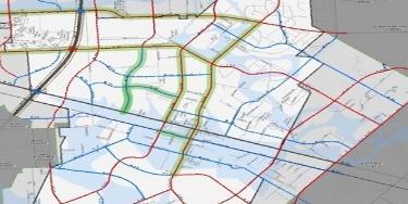
29 EXISTING CONDITIONS Local streets provide access to individual properties, residences and neighborhoods, and provide connections to the major and minor corridors. Local streets are not included in the Manvel Thoroughfare Plan, but are typically two lane streets within a 60 feet rightof-way. Examples include Rodeo Drive and Jordan Road. Traffic Volumes When evaluating existing conditions, understanding current traffic volumes on the street network is important in determining if the facility is functioning at capacity in current conditions. The Annual Average Daily Traffic (AADT) provides information on traffic history. AADT is the total volume of vehicle traffic divided by 365 days. Traffic counts can also be collected over a specific time period. This method, Average Daily Traffic (ADT) is the number of vehicles traveling in a 24 hour period, greater than a day but less than one year. Current Daily Traffic Volumes The Texas Department of Transportation Figure 1. Manvel 2013 Traffic Counts (TxDOT) maintains an extensive database of traffic counts (AADT) for Manvel and the entire Greater Houston area. Traffic Counts were available for seven locations within the city SH 6, SH 288, and FM Traffic counts were limited to these facilities because TxDOT typically only conducts traffic counts on state maintained roadways. This information was used to inform the analysis of traffic conditions in the City. The highest counts were located on the Major Thoroughfares. Traffic on these facilities are typically in excess of 20,000 vehicles per day. Facilities such as collectors and local streets have lower traffic counts and typically generate less than 10,000 vehicles per day. Figure 1 identifies the location of 2013 traffic counts in Manvel. 25

 is used as a qualitative measure to understand the amount of traffic congestion a road is experiencing. The ranking is based on a scale of A-F.")
30 EXISTING CONDITIONS Table 2 lists increases in traffic on key facilities within the city. According to H-GAC, the highest volume of traffic within the city was along SH288 in 2013 with 53,300 vehicles per day. SH6 had slightly less than half the volume with 25,200 vehicles per day. Table 2. Manvel Average Annual Daily Traffic Increase Source: H-GAC 2013 Traffic Volumes * Past estimate based on contributing network volumes. Existing Network Level of Service Level of service (LOS) is used as a qualitative measure to understand the amount of traffic congestion a road is experiencing. The ranking is based on a scale of A-F. At LOS A, vehicles experience an uncongested condition and are able to travel at the posted speed limit with no issue. At each letter interval, congestion gets worse until reaching LOS F. At LOS F, traffic congestion is highest and travelers experience severe travel time delays. For each functional class type there should be an acceptable LOS that is used to compare the traffic quality of each corridor. For example a collector may experience congestion at a lower grade scale than an arterial. Figure 2. Manvel 2014 Level-of-Service A network analysis utilizing H-GAC 2014 traffic volumes reveals several corridors within the city operating below LOS D, which is the typical minimum acceptable Level of Service for cities within the region (Figure 2). Roadways operating below LOS D include, but are not limited to SH 6 and segments of FM 1128, CR 58 and SH 288. Many other streets are operating between LOS A and C. Growth and Development Trends 26


31 EXISTING CONDITIONS Recent development activity, such as the Pomona and Sedona Lakes residential communities, has Manvel poised to exceed 20-year growth projections. Past growth trends, which correlate with H-GAC, estimate the household population in Manvel reaching 40,708 by This represents an annual growth rate of about 9.45%. Factoring in new development trends, however, has increased the growth rate to about 16% annually, and forecasts the population to reach 130,000 by 2035 according to the 2015 draft Comprehensive Plan. The disparity in the two forecasts is nearly 220%. To balance the two growth scenarios for the purpose of trip generation, a third forecast was developed based on projected commercial and residential development patterns. The demographics used for trip generation, which were vetted through Manvel City Staff, projected household population at 108,000 and employment at 10,400 in Existing and Future Land Use Evaluation The connection between land use and transportation is pivotal in the creation of a thoroughfare plan because some roadway classifications are more conducive to certain types of development than others. Major arterials, for instance, are ideal for commuters between regional destinations; collector streets are good for moving commuters internally between neighborhoods, entertainment, and commercial destinations. Figure 3. Manvel Existing Land Use Distribution Existing Land Use Evaluation Despite its proximity to Houston, Manvel has the character of a rural community. Comprised of approximately 15,000 acres (10,000 additional acres in the ETJ), the majority of the land in Manvel is vacant developable or farm land (Figure 3). The primary developed land use is residential, though there are a few clusters of commercial development scattered throughout the city and along SH 6. Undevelopable flood plain areas also encompass a relatively significant portion of the land within the city. Despite past development trends, the city is projected to receive significant growth that may make current land use trends difficult to maintain. Because of this, the new thoroughfare plan will be developed to accommodate projected land use development trends while minimizing the overall impact on the current character of the city. 27


32 EXISTING CONDITIONS Figure 4. Manvel Future Land Use Map Future Land Use Evaluation The Future Land Use Plan developed for the Manvel 2007 Comprehensive Plan was not developed like a traditional land use land use plan, which is based on Euclidian zoning, but instead a form-based approach centered on development intensity. Rather than designating desired land uses for particular areas, the desired development density is determined for an area and land uses are later incorporated into development plans as projects move forward. The 2007 Comprehensive plan allows for stepped zones of develop intensity, and a higher overall population than the H-GAC forecast. The 2015 update continues this approach and envisions development organized in a stair-stepped fashion, with the lowest density in floodplains and along natural water features, creeks and bayous, and higher levels of density arranged in clusters and closer to transportation infrastructure. The developments currently in the development process, combined with the comprehensive plan, reflect a continued pattern of growth and infill in the future. Near term projections maintained by the H-GAC indicate the population density doubling by Despite the increase in population density, the city has enough developable and redevelopable space to accommodate the additional growth. The increase is primarily the result of new residential development along SH 288 and SH 6. While Manvel has experienced less growth than Brazoria County as a whole over the last two decades, there has been a greater increase in home construction within the city over the past ten years. Non-Motorized Transportation Manvel is in the early stages of developing a nonmotorized transportation network that focuses on connecting existing destinations such as parks, neighborhoods and schools. Figure 5 depicts the Manvel non-motorized network as illustrated in the Public Facilities/Open Space Map displayed in the Draft 2015 Comprehensive Plan. 28


33 EXISTING CONDITIONS The routes proposed in the plan will be further refined and incorporated in the thoroughfare plan process to ensure compatibility and connectivity. Considerations will include both on and-off street facilities. Figure 5. Manvel Public Facilities and Open Space Map 29
34

 which have specific demographic and land use data associated with them and are used to determine trip demand and travel patterns.")
35 GROWTH FACTORS AND PROJECTED CONDITIONS Chapter 4: Growth Factors and Projected Conditions Projected travel conditions were based on an analysis of prepared demand forecasts in the H-GAC regional travel model. Data from the 2035 Regional Travel Transportation Plan served as the starting point for a manual local area analysis. A description of the modeling process in presented below. Modeling Process A travel forecast model is comprised of a series of mathematical models that simulate travel on the transportation system. The model divides the a city into Travel Analysis Zones (TAZs) which have specific demographic and land use data associated with them and are used to determine trip demand and travel patterns. The modeling process, illustrated in Figure 6, encompasses the following four primary steps: Figure 6. Four-Step Modeling Travel Demand Modeling Process Trip Generation the number of trips produced and attracted to a destination or TAZ based on trip purpose. Trip Distribution the estimation of the number of trips between each TAZ, i.e., where the trips are going. Modal Split the prediction of the number of trips made by each mode of transportation between each TAZ. Traffic Assignment the amount of travel (number of trips) loaded onto the transportation network through path-building. This is used to determine network performance. The model provides regional municipalities a refined tool to predict what thoroughfare system needs will be to accommodate future transportation needs. Growth Factors Two essential inputs for the travel demand model are population and employment data. This information helps determine where trips are generated and where those trips are going. The amount of trips produced by each person and jobs varies depending on many factors such as income and job type. When analyzing traffic data, it is important to look at both base year and the forecast/build-out years. 31


36 GROWTH FACTORS AND PROJECTED CONDITIONS Travel Demand Model Base Year Conditions H-GAC maintains an updated version of the base year demographics and transportation network for the region. For the Manvel area, unfortunately includes only major thoroughfares such as SH 288, SH 6, FM 1128, CR 99, CR 58 and CR 48. This model also requires a consistent update to the demographics by TAZ approximately every 5 years. This base year demographics provided from H-GAC were used in the analysis of the base year conditions. Figure 7. Manvel Comprehensive Plan Transportation Corridor Plan The Comprehensive Plan s planned thoroughfare network, as illustrated in Figure 6, was evaluated using a cordon-line analysis of the anticipated need and use of the transportation network for a modeled future date of Cordon Analysis A cordon analysis is a general tool to compare total traffic volumes entering and leaving the area studied. This is used in combination with the HGAC regional model in order to tie back to larger scale anticipated development patterns and roadway network growth. As part of the development of this analysis, Figure 8. Manvel Cordon Line Illustration a cordon line was established around the study area, roughly encircling Manvel and the associated TAZ, overlapping the city within the HGAC regional model. This study area, represented in Figure 8, allows for the consideration of the flows in to and out of the area, as well as more detail than the HGAC regional model. The higher level of detail than available from the regional model, as well as the updated land use from the City allows for link level capacity assessment which then informs the recommended roadway needs in this study. Recent regional growth projections by land use are shown in Figure 9. 32


37 GROWTH FACTORS AND PROJECTED CONDITIONS Figure 9. Regional Population and Employment Growth Manvel Source HGAC 2014 Travel Demand Model Outcomes The H-GAC travel demand model helps determine the capacity and thoroughfare needs in the. The goal of a thoroughfare plan is to balance the supply and demand of the roadways to ensure that the City resources are maximized and the system functions safely and efficiently. The results provide an opportunity for the transportation network to be analyzed so that adjustments can be made where necessary to maintain the appropriate network capacity to handle the forecasted traffic volumes. Figure Comprehensive Plan Transportation Network Manvel Traffic Projections The TAZs within the study area were taken from the regional model along with the land uses and amount of development assumed at the regional level for the future modeled year. The TAZs were then each analyzed in relation to the adopted comprehensive plan, adjusted as needed, and confirmed with the City as approximately representative of future conditions for location of residential and commercial uses as well as approximate development intensity. The confirmed TAZs were then used to calculate vehicle trips which were then loaded on to the network of thoroughfares from the 2007 adopted Manvel Comprehensive plan (Figure 10), including subsequent modifications to the network from the Meridiana and Pomona developments, as a basis of analysis. 33
. Traffic volumes help to determine the appropriate sizing of a road.")
38 GROWTH FACTORS AND PROJECTED CONDITIONS Thoroughfare Network Evaluation The two primary indicators for evaluating the future need is the forecasted traffic volumes and the congestion or level-of-service (LOS). Traffic volumes help to determine the appropriate sizing of a road. Congestion, on the other hand compares, the projected volumes to the proposed capacity of the roadway; this is known as the Volume to Capacity (V/C) Ratio. The results of the V/C Ratio are presented in an A through F grading system with an LOS A roadway representing free flow conditions and LOS F representing extremely congested conditions. Table 3 describes projected 2035 LOS. Vehicle trip rates, as well as directional distribution (inbound or outbound) for the overall land use types were taken from the latest version of the Institute of Transportation Engineers Trip Generation Manual. Trip destination direction (north to/from Houston and Pearland, east to/from Alvin, etc.) was estimated based on predominant travel patterns by land use type and the emphasis of north as the regional draw for residential based trips continuing in the modeled future year, but also reflecting retail based trips becoming more balanced as that development type starts to fill in over time. Tables 4 and 5 detail the results of the screen line analysis. Table 3. Manvel 2035 Traffic Volumes *HGAC 2035 model plus Manvel confirmed/specific land use and network estimates. ** Past estimate based on contributing network volumes. 34


39 GROWTH FACTORS AND PROJECTED CONDITIONS Table 4. Manvel 2035 North - South Screenline Table 5. Manvel 2035 East - West Screenline The screen line analyses served as a basis for refining the Manvel thoroughfare Plan. Both functional classification and roadway sizing were reviewed for potential modification. 35


40 Chapter 5: Thoroughfare Plan The Thoroughfare Plan consists of multiple considerations as identified above, and aims to provide for increased mobility and connectivity and reduce reliance on the automobile. Thoroughfare Plan considerations are not all inclusive and as needs change, the plan should be amended to maximize system investments to the community. Thoroughfare planning initiatives should be coordinated with other infrastructure investments within the city and/or, with other agencies to leverage financial resources and implementation timeframes. Projected Thoroughfare System Needs Manvel s current functional classification system does not offer the flexibility to accommodate the city s revised land use strategy. The current street network does not provide adequate access or connectivity throughout the city. Additionally, many of the city s existing roads do have the capacity to support planned development within the city. Revised Thoroughfare Standards To better accommodate the revised land use strategy, a range of roadway crosssections were developed to enable flexibility in considering the varying density needs for the city. Rather than a one size fits all approach, optional crosssections enable varying levels of density and accessibility. Table 6 summarizes the revised functional classifications developed for the Manvel Thoroughfare Plan. The recommended functional classification system in Manvel includes 13 different roadway types within the categories of major thoroughfares, arterial, collector, and local roads and are listed in Table 6. Additionally, Table 7 includes standards for a Boulevard Overlay to be applied to certain corridors identified by the city. The revised Manvel thoroughfare standards will not only provide roadway sections to accommodate a number of land uses, but make provisions for future right-of-way needs as well. 36

 to accommodate on street parking in front of residences")
41 The number and width of lanes typically depend on its functional classification, available right-of-way, and the adjacent land use (context sensitivity). Wider lanes typically promote higher speeds and more through traffic and reduced widths promote more bike and pedestrian activity and have a traffic calming effect. Eleven-feet lanes are wide enough to accommodate emergency vehicles, and can generally function for all classifications. However, 12 feet lanes were recommended for all road types, with the exception of local streets which have 13 feet lanes (28 feet curb to curb) to accommodate on street parking in front of residences and circulating vehicles. Table 6. Manvel Revised Thoroughfare Functional Classification *At the discretion of the City, bike lanes may be located on-street or on adjacent multi-purpose pathways. 37


42 Major Thoroughfares The Major Thoroughfares in Manvel (SH 6 and SH 288) serve two different functions within the city. SH 288 operates like a freeway, which is not typically included in a thoroughfare plan. Two toll lanes will be constructed within the median of the facility beginning in SH 6 is currently the major commercial corridor in the city and operates like a primary arterial by providing commuters from adjacent cities access to SH 288. The regional, statewide and national scale of these roadways limit the ability for Manvel to impact the decisions made on the overall operations of the roadway. However, considerations on the impact of these facilities on mobility within the City is essential as the thoroughfare planning processes continue. The typical sections for Major Thoroughfares is displayed below. Type M Street 38


 lane divided roadways with a 14 feet median, parkways and 12 feet-wide lanes within 100 feet of right-ofway.")
43 Arterials Arterials focus on moving regional traffic. These types of thoroughfares typically carry the highest amounts of traffic and also have the highest speeds depending on the context environment. The roadway types that are classified as arterials in Manvel are A streets. These roadways have four (4) lanes, a minimum ROW of 100, with options for medians and bike lanes. Examples of arterial roadways include CR 100 and Lewis Lane. Each arterial typical section is displayed below. It is important to note that bicycles can be facilitated on on-street lanes or on adjacent multipurpose pathways as directed by the City. Type A Street Type A arterials are four (4) lane divided roadways with a 14 feet median, parkways and 12 feet-wide lanes within 100 feet of right-ofway. Type A1 Street Type A1 arterials are four (4) lanes undivided roadways with parkways and 12 feet-wide lanes within 100 feet of right-of-way. Type A2 Street Type A2 arterials are four (4) lane divided roadways with a 14 feet median, a buffered bike lane (constructed at the city s discretion), parkways, and 12 feet-wide lanes within 100 feet of right-of-way. 39


44 Type A3 Street Type A3 arterials are 3 lane undivided roadways with a center turn lane. The roadway includes parkways, two 12 feet driving lanes and a 14 feet center turn lane within 100 feet of right-ofway. Type A4 Street The A4 arterials are two lane undivided roadways with large parkways within 100 feet of right-of-way. 40


45 Collectors Collectors focus on moving traffic between neighborhoods and different areas within the City. These types of thoroughfares carry moderate volumes of traffic and have lower speeds to accommodate access to adjacent properties. The minimum right-ofway for collectors in Manvel is 80 and the number of lanes range from two (2) to four (4) depending on the current and future demands and the potential development. Center turn lanes may be incorporated on Major Collectors, but raised medians are rarely found on these types of streets. Each of the typical sections for collectors is displayed below. Type B Street Type B collectors are 4 lane undivided roadways with parkways and 12 feetwide driving lanes within 80 feet of right-of-way. Type B1 Street Type B collectors are two lanes undivided roadways with parkways and 12 feet-wide lanes within 80 feet of right-of-way. Type B2 Street* Type B collectors are three lane roadways with parkways, buffered bike lanes, a 14 feet-wide center turn lane and 12 feet-wide lanes within 80 feet of right-of-way. 41

 and traffic volumes are the lowest.")

46 Type B3 Street Type B4 collectors are two lane divided roadways with parkways, a 14 feet-wide median and 12 feet-wide lanes within 80 feet of right-of-way. Local Streets Local streets are focused on providing access to homes in residential neighborhoods where speeds are less than 30 miles per hour (mph) and traffic volumes are the lowest. In most cases lane striping is not implemented and on-street parking occurs in a variety of locations depending on the surrounding uses and building types. The minimum width for a local street in Manvel is 60. Local Streets Local streets are two lane undivided roadways with parkways and 13 feet-wide driving lanes within 60 feet of right-ofway. 42


47 Parkways Recent trends in thoroughfare planning practices have provided opportunities for greater flexibility in thoroughfare design. This new trend better complements surrounding land uses by creating different roadway standards based on the users of the facility and the surrounding context. The Context Sensitive Solutions (CSS) Design Manual, written by the Institute of Transportation Engineers and the Congress for the New Urbanism, provides a guide on how this emerging practice can be implemented during the thoroughfare planning process. Opportunities for multi-modal corridors that advance economic development and create a safer, more efficient transportation system arise when the context of a roadway is taken into account during the planning and design processes. FM1128, a TxDOT managed roadway, was included among the Parkway sections because TxDOT recently become open to the idea of implementing place making road typologies, such as boulevards or parkways. In 2009 they adopted the Context Sensitive Solutions in Designing Major Urban Thoroughfares for Walkable Communities manual to help communities encourage certain types of development, sustain the character of specific areas, and/or lay the framework for future sustainable development. Additionally, TxDOT revised their process design manual to require context sensitive design be considered in project evaluations. The context sensitive approach has been has already been successfully implemented in thoroughfare planning processes in other cities across the Texas. The Manvel Thoroughfare Plan will advance the concept context sensitivity by incorporating a desired small town feel to specific corridors. These corridors will offer a wider median or on-street parking to give a spacious feel. The corridors will also have enough right-of-way to accommodate bike lanes, multi-purpose pathways, potential equestrian trails. For the Manvel Thoroughfare Plan, parkways are typically roads that do not originate in Manvel, but provide seamless connectivity across the city from one end to the other. Parkways will not only provide multimodal connectivity to match the higher density land use designations in the future land use plan, but will allow the city to do so while maintaining the rural feel of its roadway system as well. Parkways will be included in the Manvel s functional classification system and the city s Design Criteria Manual. Two (2) Parkways sections (P1 & P2) were created to include a range of options within 120 feet of right-of-way. P1 is a four (4) lane divided section with open parkways. P2 is a four (4) lane divided section with 6 feet buffered bike lanes and a multipurpose pathway. Detailed descriptions of the parkway cross-sections are available in Table 6. 43

 lane divided roadways with 18 feet-wide parkways, six (6) feet")
48 P1 Parkway P1 parkways are four (4) lane divided roadways with 12 feet-wide multi-purpose pathways within a 26 feet parkway, 12 feet-wide travel lanes, and a 14 feet-wide median within 120 feet of right-of-way. P2 Parkway P2 parkways are four (4) lane divided roadways with 18 feet-wide parkways, six (6) feet buffered bike lanes, 12 feet-wide travel lanes, and a 14 feet-wide median within 120 feet of right-ofway. 44


49 Key Intersections The ability for the roadway network to operate effectively relies on the ability of intersections to efficiently process traffic. Operational conditions typically break down when insufficient turn-lane capacity is available to remove turn movements from the traffic stream. To ensure the ability to provide channelized turn movements, such as a left or right-turn lane, additional pavement should be provided to allow for these facilities at key major intersections within the city. To determine the exact dimensional requirements of specific intersections, a traffic analysis and/or the recommendation of the City Engineer should be conducted at the time of facility implementation. Figure 11. Manvel Key Intersections As currently defined, divided roadways have the ability to accommodate a separate left-turn lane within medians. For undivided roadways, the intersection would need to be flared to provide sufficient roadway width for left and/or right-turn lanes. Thirty-seven intersections have been identified as key intersections and fall primarily on arterial facilities. At these intersections, the City should require additional right-ofway via the platting process (where possible) to allow for additional turn lanes. Dependent on needs, an additional of right-of-way may be necessary. Traffic Signalization It is anticipated that most arterial/arterial intersections may require signalization in order to manage traffic operations. As warranted, the city should require the implementation of traffic signalization. Dependent on the design/phasing of roadway and intersection improvements, installation of temporary (via span-wire) or permanent signalization (mast-arm) should be implemented based on the recommendations of a traffic analysis and/or the recommendation of the City Engineer. To define the look of permanent traffic signalization, the city should prepare design standards to identify signal type and characteristics for use within the 45


50 city. In special areas, such as defined mixed use areas or Traditional Neighborhood Design (TND) concepts are to be implemented, special design standards may be developed to fit in with the defined context and character of the area. Non-Motorized Transportation Vision Non-motorized transportation is one of the most essential elements of a transportation network. This is because all trips, regardless of mode, begin with the pedestrian. It is important to build a transportation network that not only accommodates, but plans for pedestrian and bicycle activity. Common elements of a non-motorized network include on-street and off-street bike trails, signed bike routes, and sidewalks. Manvel s non-motorized network includes both on street and off street bike facilities and the inclusion of sidewalks and pedestrian amenities along a number of corridors within the city. Pedestrian Accommodations One of the primary functions of the nonmotorized network is to provide safe and comfortable accommodations for pedestrians. In urban contexts, the pedestrian area is available to provide access to businesses, which can include other elements such as street trees, public art, and outdoor seating. In more suburban contexts, the pedestrian area has multiple functions. It provides access to schools, shopping and transit stops, while at the same time providing a public space for people to enjoy recreational activities such as walking and jogging. The width of the pedestrian area varies by context. Where high volumes of pedestrians are found, sidewalks and pedestrian infrastructure should be more available, including wider sidewalks. In suburban areas, sidewalks may not need to be as wide, due to the limited use that occurs on a daily basis. Non-Motorized Transportation Elements Sidewalk A primarily pedestrian offstreet facility between the curb line of the roadway and the adjacent property. Shared Use Path - An on or off-street facility separated by a barrier or open space that is designed to accommodate all non-motorized modes including pedestrians, bicyclists, skaters, and joggers. 46

51 These elements are often bolstered by landscaping and pedestrian amenities such as benches, shade trees, pedestrian lighting, and raised cross walks. Bicycle Facilities Bicycle facilities vary from dedicated on-street bike lanes to shared lanes to off-street trails and bike paths. Bicyclists skill level varies so the type of bike facilities also corresponds to the skill level of the common rider. Not every roadway in the city needs to accommodate bicycle infrastructure, and not all roadways will have the right-of-way to provide bicycle infrastructure, but it is important for the bicycle infrastructure to correspond to a system of interconnected routes that traverse the city. The design of bicycle facilities vary depending on the facility type, but it is important for the design to be coordinated with the city s bicycle plan, parks plan and comprehensive plan. The street width, speed and volume of the vehicle traffic on the roadway are the most critical factors in determining the type of bike infrastructure that may be implemented. Non-Motorized Transportation Elements Shared Use Path - An on or offstreet facility separated by a barrier or open space that is designed to accommodate all non-motorized modes including pedestrians, bicyclists, skaters, and joggers. Cycle Track On or off-street facilities, designated for bicyclists that is separated from sidewalks, motorized travel lanes, and parking lanes by a physical barrier. Bike Lane On-street facility, designated for bicyclists that is separated from the motorized travel lanes through pavement striping. Buffered or Barriered Bike Lanes - On-street bike facilities separated from motorized travel lanes by a buffer (typically four (4) to six (6)feet) and/or a physical barrier such as bollards or curbs. Wide Paved Shoulders Wide shoulders, typically along rural highways, used to accommodate bicyclists and joggers. 47


52 Bicycle and Pedestrian Connections One of the strategies the City wants to use to balance traditional rural character with future development plans is the use of open space and wider rights of way to encourage connectivity by all means of travel between residential development, schools, and parks. The Manvel bike and pedestrian network will include provisions for both on-and off street bike routes, illustrated in Figure 9, and the inclusion of sidewalks and multi-purpose pathways in the recommended thoroughfare plan crosssections. The non-motorized network included in the 2009 Comprehensive Plan was reviewed for consistency with the revised thoroughfare sections proposed as part of the Thoroughfare Plan map. The non-motorized network was created as a supplement to the thoroughfare plan and to facilitate pedestrian and bicycle activity. Bike lanes and trails are included in the thoroughfare plan (as options) to ensure adequate right-of-way if demand does materialize for bikes. In order to make a more pedestrian and bike friendly environment, the plan recommends the installation of landscaping and pedestrian amenities. Pedestrian Amenities Manvel, like most cities in the Southeast Texas region, is hot and humid in the summer months. This is not only a deterrent to pedestrian and bike activity, but outdoor activity as well. In order to combat this, and facilitate bike and pedestrian activity, pedestrian scale streetscape improvements, such as street trees, landscaped medians, benches, and ADA compliant ramps need to be installed. Pedestrian amenities not only defragment the human environment to visually reduce the distance between walking destinations, but create a framework for economic development. These elements will help maintain and bolster a Manvel s sense of place, and act as a traffic calming measure to create a safer street network. Medians Medians are located at the center portion of the travel way and have been considered for each of the street 48
53 types (A, B, and Boulevard Overlays) within the city. The width of the median can vary, but their purpose is the same, to provide a buffer between opposing directions of travel. The increased safety that a raised median provides is significant. Roadways with raised medians can reduced the crash rate by over 50% in contrast to similar roadways without a raised median. In addition to the safety benefits of median inclusion, raised medians provide a location for added corridor aesthetics such as landscaping, lighting and urban design features. 49

54 RECOMMENDATIONS Chapter 6: Thoroughfare Plan Recommendations Functional Classification Recommendations The thoroughfare network is the foundation of the entire surface transportation system. Local streets provide access to abutting and adjacent land and major thoroughfares accommodate through traffic. The overall function of a road, however, is largely dependent on the adjacent land uses. Figure 12. Functional Class and Land Use Accessibility The majority of large cities in Texas incorporate a traditional functional classification system to organize roadway types within their jurisdiction. This system provides key information and standards for each roadway type to assist citizens and developers in understanding the types of roadways that are planned for the region s transportation system and how those roadways may be designed. The existing classification system of major thoroughfares, major corridors, minor corridors, and local streets are adequate for the existing land uses patterns, but a revised system is needed to accommodate the city s future land use plans. Manvel s revised functional classification incorporates provisions for multimodal accessibility, a potential mix of development densities, and provisions to better accommodate emergency vehicles. Functional Street Classification System Analysis and Recommendations In the past, functional classification systems have been rigid and inflexible, providing little ability to incorporate alternative design options. This concept of rigidity has evolved over time as the relationship between transportation and land use has become more influential in the design and operation of our streets. Now, as development patterns are changing, roadways are accommodating multiple modes of transportation. Thoroughfare design practice has begun to involve a number of different design considerations such as pedestrian, bicycle and transit accommodations. This has resulted in a variation of the typical street design along certain corridors to incorporate multi-modal design implementation. Recommended Roadway Amendments Table 7 summarizes recommended revisions to the Manvel Thoroughfare Plan. The revised classifications will inform decisions on the appropriate cross-section to apply to various roadways within the city and ETJ. The updated Thoroughfare Plan is illustrated in Figure 13. Recommended functional classification amendments were based on 50

55 RECOMMENDATIONS projected traffic volumes and/or to improve connectivity with the city to support current and future development. Table 7. Manvel Functional Classification Amendments 51
56 RECOMMENDATIONS The following summarizes the justification for upgrading several key Manvel roadways to either parkway or arterial class facilities. Collector and local facilities were amended improve the overall connectivity of the thoroughfare network. Bissell Rd., for instance, was upgraded from a two (2) lane local road to a four (4) lane arterial facility to provide supplemental east-west connectivity for SH6 and a secondary route in emergency and high congestion scenarios. Masters Road (FM1128) Masters Road, between CR 100 and SH6, is currently a two (2) lane arterial that carries about 6,900 vehicles per day and operates a level-of-service A (table 3). Given the projected growth and development within the city, traffic volumes are projected to surpass 23,000 by To accommodate the projected increase in traffic and maintain existing levels-of-service, the plan recommends upgrading the roadway to a four (4) lane parkway facility. Rodeo Palms Rodeo Palms is currently a two (2) lane collector facility operating at a level-of-service A. Presently the roadway extends from the Rodeo Palms subdivision to SH288, but the thoroughfare plan recommends extending the roadway from the proposed Kirby Drive extension near the western limits of the city to CR99 at the eastern limits. The alignment will connect Del Bello, Belcher, and CR397. The Rodeo Palms development, located at the intersection of SH288 and Rodeo Palms Pkwy, is projected to bring in 1,732 new households, which equate to about 5,000 new residents. Additional planned developments that will like impact the facility include Sedona Lakes (609 residential units 1,700 residents), Lakeland (649 residential units 1,900 new residents). To accommodate the planned growth and development and provide additional east west connectivity through the city, the plan recommends upgrading the facility to a four (4) lane parkway within 120 feet of right-of-way. Croix (CR 58) Croix Road, between CR48 and CR90, is currently a two (2) lane arterial class roadway that facilitates about 4,000 trips per day and has segments operating between level-ofservice A and F. Additionally, traffic volumes are projected to reach 18,300 by 2035, an increase of 457%. To combat the projected increase and maintain a consistent level-ofservice, the plan recommends widening the road from two (2) to four (4) lanes and upgrading the functional classification to a parkway. To improve connectivity and support projected development, the plan also recommends extending the road east to the city limits at CR99 to improve connectivity. CR 90 CR90, between Rodeo Palms Parkway and Bailey Avenue, is currently a two (2) lane arterial class facility operating at a level-of-service A with approximately 3,000 trips per day. The roadway, however, is projected to reach level-of-service E-F by Additional traffic generated by Rodeo Palms, Sedona Lakes, and Lakeland may further exacerbate the conditions. To accommodate the planned growth and development and provide an additional north south route through the city, an upgrade to parkway class and widening from two (2) to four (4) lanes is recommended for the roadway. The plan also recommends extending the roadway south from Del Bello to SH6. 52
57 RECOMMENDATIONS Smith Ranch (CR 94) Future Manvel Parkway Smith Ranch is currently a 2 lane collector facility between the northern city limits and CR101. Given the projected growth and development in the area, 2035 traffic forecast estimate about 16,700 trips along the roadway per day. To address this issue, the plan recommends widening the roadway from two (2) to four (4) lanes and upgrading the facility to parkway status. To improve overall connectivity in the area and provide an additional north-south route, the plan recommends extending the facility to the southern city limits. CR 100 CR100 is currently a two (2) lane arterial facility that operates at a level-of-service A. Presently the roadway extends from the CR90 to CR100B, but the thoroughfare plan recommends extending the roadway east of Masters RD to the city limits. The alignment will provide a northern east-west route through the city and provide access to Pearland. It will also provide a major entrance way into the Sedona Lakes development. Peters Road/ McCoy/ Meridiana Parkway When McCoy crosses SH6 it transitions into Peters Road/ Meridiana Parkway. This roadway is important as it provides a key access point to the Meridiana development. The roadway is currently a two (2) lane arterial facility extending just south of Jordan Road, but the plan recommends upgrading the facility to a Parkway. Additional enhancements include extending the road south through the Meridiana development to the southern city limits. The roadway s traffic volumes are projected to reach 10,000 vehicles per day by To combat the increased volumes and accommodate the Meridiana development, the plan recommends widening the roadway from two (2) to four (4) lanes and expanding the right-of-way to 120 feet. Markham Lane Markham Road is currently a two (2) lane local road located north of CR95C. To accommodate the need for an eastern north-south route to Pearland, the plan recommends upgrading Markham lane to a parkway class facility, widening it from two (2) to four (4) lanes and extending the roadway south to Uzzell Road and north to the northern city limits just past CR98. With this upgrade and projected development, the roadway is forecasted to accommodate 10,000 trips per day. Kirby Drive Kirby Drive is currently a two (2) lane major corridor located less than a mile west of SH 288. The roadway currently extends from the northern city limits to CR 566X, but the thoroughfare plan recommends upgrading the functional classification to a parkway, extending the roadway south to SH 6 and adding two (2) additional travel lanes. The recommended right-of-way for the Kirby Drive is 120 feet to match Pearland s plans to widen the roadway. 53

58 RECOMMENDATIONS Thoroughfare Plan Map Figure 13. Manvel Thoroughfare Plan Map 54


59 RECOMMENDATIONS Non-Motorized Vision Recommendations Recommended alignments for the onstreet trails included in the nonmotorized section of the thoroughfare plan were based on alignments identified in the 2009 comprehensive plan and on projected volumes and level of service. Bike lanes were not recommended for high volume or high level-of-service roadways. Trails located on arterial or parkway class facilities (see Table 6) should be constructed with buffers, rumble strips curbs, or barriers to provide additional safety. Additionally, bike lanes should not be added to Manvel roadways under their existing conditions, but instead, as they are reconstructed with new development. Bike lanes will not be constructed on roadways where there is not sufficient right-of-way to accommodate both bikes and automobiles safely. Where the necessary right-of-way is not available, off-street trails may be implemented rather than on-street routes. Because of this, we developed alternative sections (A, A1, A2, B1, B3 & Local Roads) that can accommodate off-street bikes in multi-purpose pathways. The construction of on-street lanes and off-street trails should be at the discretion of the City and should be implemented over the long term as development occurs. The City should have the option to refer to the bike plan and thoroughfare plan and recommend easements for the construction of trails and routes. On-Street Trail Recommendations The on-street routes illustrated in the Comprehensive Plan were evaluated using the Future Land Use Plan, revised thoroughfare network, schools, and existing and planned development around the city. Routes were added or removed based on their feasibility within the thoroughfare sections in terms of functional class, available right-of-way, and projected traffic 55

60 RECOMMENDATIONS volumes. The Manvel PD&Z recommends constructing on-street bike trails on roadways receiving a large amount of long distance bike travel. Table 8 summarizes the recommended on street bike lanes. Table 8. Manvel On-Street Bike Lane Recommendations 56

61 RECOMMENDATIONS Figure 14. Manvel Non-Motorized Network Vision 57
62
63 RECOMMENDATIONS Additional Plan Recommendations At the completion of plan review, the Manvel Planning, Development and Zoning Committee (PD&Z) made additional recommendations to ensure seamless compatibility between the Thoroughfare Plan, Design Criteria Manual, Parks Ordinance, and Subdivision Ordinance. The following section lists key additions to existing city ordinances proposed by the Manvel PD&Z Committee. Manvel Design Criteria Manual Recommendations The following amendments were recommended to the Manvel Design Criteria Manual: Section Design Requirements. The function street classifications listed under B. Minimum Width Requirements and Paving should be amended to match the functional classifications developed for Manvel s Master Thoroughfare Plan. Additionally, FM 1128, currently listed as a Major Thoroughfare, will be removed from the list of Major Thoroughfares and placed on the list of Parkways. Additional language should be added to Section 1.04 specifying the need for more ROW at intersections to accommodate multi-use paths and turn lanes. Under I. Requirements for Curb and Sidewalks, either sidewalks or multi-use trails will be required along all curb or gutter streets. The language should read Sidewalks or multiuse trails are required along all curb or gutter streets. Under J. Requirements for Miscellaneous Items, landscape irrigation sleeves will be required when constructing medians on divided roadways. Landscape irrigation sleeves are pipes, installed in irrigation systems, which allow control wiring or lateral pipes to the easily installed under hard surfaces. A 19 th items will be added to the list of miscellaneous items and will include the following language: Sleeves for future irrigation shall be installed when constructing medians in any divided road. Subdivision Ordinance Recommendations The following additions were recommended for the Manvel Code of Ordinances Subdivision Chapter: The Definitions section of the Manvel Subdivision ordinance (Sec. 62-2) needs to be amended to include the new functional classifications recommended in the thoroughfare plan including the Parkway classification. The new right-of-way requirements should be listed in the Streets section of the Subdivision Ordinance (Sec ) under number 11 (a) (b) and (c). 59

64 RECOMMENDATIONS Park and Recreation Ordinance Recommendations The following additions were recommended for the Manvel Code of Ordinances Parks and Recreation Chapter: The Manvel Parks and Recreation Chapter should be amended so developers can receive credit for building trails within the street ROW. Currently credit is given if the trail space has an average width of 30 feet and is at no point narrower than 20 feet. The available ROW on many Manvel streets is smaller than this requirement. Providing credit for all trails constructed in the public ROW may be an incentive for developers to construct additional trails in the public ROW. The developed several provisions to through which developers can receive credit for parkland dedication including the development of neighborhood parks, bike and pedestrian trails, and Money in lieu of land. Under the Trails provision of Section Parkland and Dedication Requirements, land dedicated for trails have to contain an average minimum width of 30 feet and a minimum width of 20 feet PD&Z recommends issuing credits commensurate with the actual square footage of the greenspace if the trail is constructed on a street with at least 80 feet of ROW. The revised language should read: o d. Contain an average minimum width of 30 feet and a minimum width of 20 feet, unless said trail is located on a city ROW. If a trail is constructed on a street ROW of 80 foot or larger, the area containing the trail shall count towards the trail credit. Miscellaneous Ordinance Recommendations The following recommendations were developed for various City ordinances to ensure compliance and compatibility with the Master Thoroughfare Plan. Language needs to be added to the Signs Chapter of the Manvel Code of Ordinances to include provisions for additional right-of-way at the city limits for monument signs. A section needs to be added to the Utilities (chapter Chapter of the Manvel Code of Ordinances to add language on utility easements. Particular attention should be given to the use of easements to bury power lines along designated parkways. Language needs to be added to Chapter 41 Traffic and Motor Vehicles under Section 41-1 Manual on Traffic Control Devices for the installation of mast lights at intersections. Capital Improvement Considerations Manvel s current Capital Improvements Plan (CIP) includes provisions for two transportation initiatives: a Street 60

, traffic counts, drainage issues, past repairs, and the presence of lime.")
65 RECOMMENDATIONS Maintenance Plan (2016) and the Masters Road Rehabilitation Project (2016). The Thoroughfare Plan Identifies 24 additional projects to be added to the cities long and short term Capital Improvements Plan. Street Maintenance Plan The Street Maintenance plan will include an inventory of all City managed streets that includes an evaluation of roadway condition (thickness, pot holes, etc.), traffic counts, drainage issues, past repairs, and the presence of lime. This is currently a low priority project for the City, but could provide the foundation for the major roadway system overhaul needed to accommodate the Comprehensive Plan s projected population growth. Masters Road Rehabilitation Project The Masters Road Rehabilitation Project is a major reconstruction project spanning from SH 6 to CR 100. The project, also identified in the Northern Brazoria County Pearland Sub Regional Planning Initiative, will retrofit the roadway with concrete, curb, and gutter. Short-term and Long-Term Capital Improvements Below is a list of recommended short-term and long-term Capital Improvements for the. Short-term and long-term projects are envisioned to occur within 10 and 20 years respectively. Short Term Capital Improvements Long Term Capital Improvements A complete table of long and short term capital improvements that includes additional project information is available in Appendix B. State Highway 6 Intersection Improvements 61
, and Corporate Drive. Additional intersections were identified by Manvel staff at Markham Lane, and Cemetery Road.")
66 RECOMMENDATIONS The State Highway 6 South Corridor Access Plan, completed in 2011, recommended studies be completed for potential traffic signals along SH6 at the intersections of Iowa Lane, Colony Drive (Manvel Parkway), and Corporate Drive. Additional intersections were identified by Manvel staff at Markham Lane, and Cemetery Road. The potential signals cannot be implemented without the completion of traffic signal warrant studies and TxDOT approval. Figure 15. Manvel Recommended Traffic Signal Locations Thoroughfare Plan Updates Manvel is anticipated to undergo tremendous growth over the next twenty years. Because of likely changing conditions, the thoroughfare plan should be reviewed on an annual basis and revised accordingly. At a minimum, the Thoroughfare Plan should be reviewed every 5-years. 62

67 RECOMMENDATIONS Traditional Neighborhood Development Areas designated for Traditional Neighborhood Development (TND) use traditional town planning principals to create a livable-scale neighborhood by focusing on design, connectivity, layout and character of use. This concept is also often referred to as New Urbanism. The comprehensive plan identifies several areas as potential TND s, which include those identified as Transect Zones 4, 5 or special districts in the ID zones mapping of the plan, generally close to the commercial corridors of SH 6 and SH 288. Traditional neighborhood development areas allowing more walkable opportunities nearby, and safe, comfortable options for routes to walk as well as destinations to walk to. Characteristics of this land use type often include lower speed roads with narrower cross sections to encourage safe walking, a mix of residential uses, sidewalks buffered from roads, reduced setbacks from roadways for buildings, and some neighborhood scaled retail use, schools, neighborhood parks and civic buildings within a half mile to allow options nearby to live and play. They may also include design elements like networks of paths for walking and biking, porches on the fronts of houses, pedestrian scaled lighting, benches, street trees and landscaping. Current regulations within the city may allow for some portions of TND, such as limited block lengths, but others would inhibit implementation of this development type. To better enable the Manvel City Code to allow for TND s, the following sections of the subdivision code are recommended to be modified: For a TND within the City limits: Sec :(4) Block lengths should be a maximum of in a TND. Sec (b) (1) front residential setbacks should be no more than from sidewalks. Sec (b) (2) Lot dimensions may be vary depending on the setback depth and whether shared or rear-lot access via an alley is provided. Sec Sidewalks should be constructed a minimum of 5 feet wide. Sidewalks should be offset from roadways by a minimum of 4 plantable space. Sec Develop access management standards for TND. If roadways narrower than 60 are sought, more sections of the subdivision code will need to be revised. Illustrative for residential and non-residential roadways are included on the following pages. 63


68 RECOMMENDATIONS A new zoning district type could be created in the zoning section of the municipal code in order to allow the different uses to be constructed next to the existing ones. Alternatively, new developments with TND characteristics can also be achieved by incorporating all elements into a planned development through the use of a form based development standard. An example of such subdivision regulations is included as Attachment A. Standards for TND type streets should include cross sections that are pedestrian friendly and function to calm traffic, and discourage through traffic as illustrated by the examples below. An example of a TND Subdivision Code is available in Appendix A. 64


69 RECOMMENDATIONS For Commercial Streets: 65


70 RECOMMENDATIONS Complete Streets Integration One of the recommendations provided under the transportation goals in the Draft 2015 Comprehensive plan is the review and incorporation of complete streets policies in the Thoroughfare Plan. Complete Streets is a relatively new transportation planning approach that aims to maximize the use of public rights-of-way for all transportation users, regardless of age, ability, or modal choice. This method uses high-level policy direction to influence everyday decision-making processes in roadway design, rather than design prescription. Complete Streets is not about special projects, but about changing the approach to projects on all streets. It is an incremental approach aimed at long-term results. These policies utilize the entire right-of-way while focusing on safety, comfort, and convenience as well as cohesiveness within the context of the community. Complete Streets make it easier to cross the street, walk to shops, and bicycle to work which in turn makes the town a better place to live. These traits are essential to a seamless multimodal transportation network. Benefits Complete Streets improve safety, provide modal choices, reduce costs, and lead to better health and stronger economies. By considering the many different users of the roadway, streets can be designed to accommodate everyone and improve the livability of the community. Improve Safety Reduced travel speed which lowers risk to pedestrians and cyclists as well as include pedestrian infrastructure such as sidewalks, bicycle lanes, crossings, median islands, and curb extensions. Provide Modal Choices By building safe, comfortable, and convenient infrastructure for other modes of transportation, residents are more willing to use them. Reduced Costs Encouraging and installing provisions for non-motorized transportation particularly within and around employment and activity centers, reduce transportation system operation and maintenance costs. It also decreases travel costs for Manvel residents who 66

71 RECOMMENDATIONS can walk or ride a bike to work as opposed to automobiles alone. Further, by reevaluating the needs of the residents and incorporating community input at the beginning of the project, the schedule, scope, and budget can often be reduced. Narrowing the pavement area will also reduce costs. Better Health Accommodating pedestrians and bicyclists in the transportation network add to the overall health of Manvel. Active adults, in addition to kids and teens who cannot drive look for pedestrian and bicycle facilities to become more active and independent. Stronger Economies Areas that provide safe and comfortable walkability have lower commercial vacancies and higher home and office space values. Economic Benefit Complete Streets affect the local economy in various ways. By providing convenient alternatives to driving, such as transit, walking, or biking, residents and visitors save money on transportation costs which can then be used for other expenses, such as housing, restaurants, and entertainment. Congestion costs can also be reduced if residents use alternative modes. Local businesses see the benefits in improving access to people traveling by foot or bicycle. By increasing pedestrian and bicycle activity, businesses often see increased sales. Bicycle infrastructure can often create jobs directly through increased tourism, bicycle manufacturing, sales and repair, bike tours, and other activities. Complete Streets also create a framework for economic development and spur private investment by improving the public space and making it a more pedestrian- and cyclist-friendly place. This is pivotal as Manvel attempts to invigorate downtown and create a more walkable commercial environment. In a downtown area or along commercial boulevards, the complete streets framework defragments the overall development landscape by visually reducing the space the between developments and encouraging pedestrian movement between adjacent businesses. By revitalizing parts of Manvel with pedestrian plazas, wide sidewalks, landscaping, and traffic calming elements, private investors may be more willing to build or redevelop residential, retail, and office buildings. In addition to private investments, property values increase with the walkability of a neighborhood. Today s college graduates, who comprise an increasing percentage of the workforce and add to the vitality of a local economy, prefer walkable urban neighborhoods. 67
72 APPENDIX Appendix A 68
73 APPENDIX Appendix A Example Subdivision Code El Paso Chapter ALTERNATIVE SUBDIVISION/SMART CODE DESIGNS Sections: Purpose. Purpose. It is the purpose of this title to provide for the consideration of alternative subdivision designs, smart growth and form based subdivisions, infill developments, mixed-use districts and alternative improvement designs and engineering which differ from the conventional design standards as outlined within this article of this title, but which are based upon sound engineering, planning and urban design practice. Infill development provisions would encourage the development of smaller, isolated tracts of land in the inner city or the area surrounding it that have been passed over by development and have remained vacant for years, and may include platted or unplatted land. "Alternative subdivision improvements" means alternative designs for physical improvements such as streets, water and wastewater, as well as any other infrastructure element of a proposed development. Smart code subdivisions are those adopted in accordance with the Smart Code provisions of the City of El Paso. (Ord (part), 2008) (Ord. No , 27, ) Infill development. A. Intent and Purpose. The following guidelines are designed to meet the intent and purpose of the infill sections, requirements and references in Title 20, the zoning ordinance to reinvigorate existing communities and neighborhoods and support new compact, single or mixed-use development. This chapter is intended to reduce barriers to infill development, and to provide incentives such the use of flag lots and private drives, reduced drainage standards on smaller parcels, reduced fees and participation in or reduced requirements for infrastructure. B. Application. An application for an infill development procedure shall be submitted at the time of preliminary plat application. The infill development subdivision design will be reviewed under the provisions outlined in the zoning ordinance under the alternative subdivision design provisions for infill development, as well as in Chapter 19.03, Preliminary Plat, of this title, as amended and provisions outlined in this title. The infill subdivision improvement plans and applicable incentives must be submitted, requested, reviewed and approved prior to final plat approval of an infill development and recordation. All applications shall be submitted on a form supplied by the planning division with the required information as stated on the application form and meeting the administrative submission requirements available in the planning division. C. Designated Areas. The provisions of this chapter shall apply to areas designated for infill development in Title 20, the zoning ordinance. D. Zoning Districts and Related Single-Family Lot Sizes. The applicable zoning districts in which the infill development procedure may be used and the infill development standards that may be permitted for single-family uses through the use of the procedure shall be as allowed by the infill development provisions of the zoning ordinance. E. Incentives. In addition to the incentive of smaller lots and higher density in accordance with the zoning ordinance, the following incentives are available in developments meeting the requirements of this chapter: 69
74 APPENDIX 1. Reduced Fees. The city manager or designee shall waive the development fees associated with the subdivision review and approval process for qualified projects. The El Paso Water Utility may waive one or more fees associated with water and wastewater service, including hookup fees, for qualified projects; 2. Replat Fees and Approval. While replatting laws of the State of Texas must be observed, replats with less than four lots may be administratively approved in accordance with this chapter without a public hearing and the fees may be waived as described above; 3. Infrastructure Cost Participation. The city council may choose to pay for additional participation in public infrastructure beyond what is required by this chapter for a qualified infill development. The determination by the city council shall be made prior to the approval of the final plat and may include but is not limited to: a. Construction, repair or replacement of public streets, curbs and gutters or alleys, b. Construction, repair or replacement of sidewalks, street lighting or other pedestrian improvements, c. Construction, repair or replacement of storm drainage facilities; 4. Water and Wastewater. The El Paso Public Water Utility may choose to pay for additional participation in public infrastructure by this title for a qualified infill development; 5. Stormwater and erosion control. Infill projects that create less than ten thousand square feet of new impervious surface are exempt from the stormwater requirements, excluding stormwater utility fees. 6. Park fees for residential infill development occurring within the area identified in Appendix 112 shall be reduced by the reduction identified in Appendix Park dedication or fees are reduced by 50 percent for a non-residential subdivision up to five acres in size that satisfies the location criteria below for infill development, but that has not been designated by special permit overlay as infill development. At least two of the following factors must be present: a. the property is wholly or partially located within a designated tax increment financing district; b. the property is wholly or partially located within a designated state or federal enterprise zone; c. the property is wholly or partially located within an empowerment zone; d. the property is wholly or partially located within a designated redevelopment area pursuant to Chapter of Title 20 e. the property is located within a designated historic district; f. the property is within an older neighborhood of the city, which is defined as a legally recorded and developed subdivision for at least thirty years. (Ord (part), 2008) (Ord. No , 2, 27, ; Ord. No , 20, ; Ord. No , 2, ; Ord. No , 1, ) Reduced roadway and lot frontage requirements. A. Flag Lots and Reduced Roadway and Lot Frontage Requirements. Public streets serving single-family residential lots may be replaced by private roadways (access 70
75 APPENDIX lanes) twenty feet wide within a minimum thirty-foot easement used to serve up to eight lots. B. Such roadways and access lanes shall be shown in an easement dedicated to the property owners and public agencies that is designated by a note on the recorded plat as a "perpetual reciprocal easement." C. Such private access lane may be allowed with designation as an infill development or in other single-family residential zoning districts if the CPC finds: 1. Physical conditions preclude development of the street, such conditions may include, but are not limited to, topography or likely impact to natural resource areas such as Arroyos, wetlands, ponds, streams, channels, rivers, lakes or upland wildlife habitat area or are source on the National Wetland Inventory or under protection by state or federal law; 2. Buildings or other existing development on adjacent lands including previously subdivided but vacant lots or parcels physically preclude a public street now or in the future considering the potential for redevelopment; 3. If the applicant can demonstrate that a future street cannot be made to serve the property, then the application for plat approval shall be processed subject to subdivision standards; 4. For lots or parcels that do not extend from one street to another, the following diagram indicates how up to four lots may be platted fronting on a twenty foot wide access lane that extends up to two hundred feet in depth. Lanes in excess of two hundred feet must be twenty-four feet wide with an additional four feet of easement and be designated as a fire lane; 71
76 APPENDIX 5. For lots or parcels that do extend from one street to another, the following diagram indicates how up to eight lots may be platted fronting on a twenty foot wide access lane that extends up to four hundred feet in depth; 72

77 APPENDIX 6. The following diagram indicates how two separately owned adjoining parcels or lots may provide or be sequenced to provide thirty feet of easement and twenty feet of access lane; 73
Exhibit 1 PLANNING COMMISSION AGENDA ITEM
 Exhibit 1 PLANNING COMMISSION AGENDA ITEM Project Name: Grand Junction Circulation Plan Grand Junction Complete Streets Policy Applicant: City of Grand Junction Representative: David Thornton Address:
CITY OF COCOA BEACH 2025 COMPREHENSIVE PLAN. Section VIII Mobility Element Goals, Objectives, and Policies
 CITY OF COCOA BEACH 2025 COMPREHENSIVE PLAN Section VIII Mobility Element Goals, Objectives, and Policies Adopted August 6, 2015 by Ordinance No. 1591 VIII MOBILITY ELEMENT Table of Contents Page Number
Vision: Traditional hamlet with an attractive business/pedestrian friendly main street connected to adjacent walkable neighborhoods
 N D. Focus Area II Vision: Traditional hamlet with an attractive business/pedestrian friendly main street connected to adjacent walkable neighborhoods Transit Road Focus Area II is located in the Hamlet
Executive Summary Route 30 Corridor Master Plan
 Route Corridor Master Plan Project Overview The Route Corridor Master Plan is a coordinated multimodal transportation and land use plan for the entire stretch of Route through East Whiteland Township,
ACTIVE TRANSPORTATION
 ACTIVE TRANSPORTATION Mobility 2040 Supported Goals Improve the availability of transportation options for people and goods. Support travel efficiency measures and system enhancements targeted at congestion
o n - m o t o r i z e d transportation is an overlooked element that can greatly enhance the overall quality of life for the community s residents.
 N o n - m o t o r i z e d transportation is an overlooked element that can greatly enhance the overall quality of life for the community s residents. 84 Transportation CHAPTER 11 INTRODUCTION Transportation
Solana Beach Comprehensive Active Transportation Strategy (CATS)
") Solana Beach Comprehensive Active Transportation Strategy (CATS) 3.0 Goals & Policies The Solana Beach CATS goals and objectives outlined below were largely drawn from the Solana Beach Circulation Element
Solana Beach Comprehensive Active Transportation Strategy (CATS) 3.0 Goals & Policies The Solana Beach CATS goals and objectives outlined below were largely drawn from the Solana Beach Circulation Element
Chapter 7. Transportation. Transportation Road Network Plan Transit Cyclists Pedestrians Multi-Use and Equestrian Trails
 Chapter 7 Transportation Transportation Road Network Plan Transit Cyclists Pedestrians Multi-Use and Equestrian Trails 7.1 TRANSPORTATION BACKGROUND The District of Maple Ridge faces a number of unique
Living Streets Policy
 Living Streets Policy Introduction Living streets balance the needs of motorists, bicyclists, pedestrians and transit riders in ways that promote safety and convenience, enhance community identity, create
Transportation Master Plan Advisory Task Force
 Transportation Master Plan Advisory Task Force Network Alternatives & Phasing Strategy February 2016 BACKGROUND Table of Contents BACKGROUND Purpose & Introduction 2 Linking the TMP to Key Council Approved
City of Wayzata Comprehensive Plan 2030 Transportation Chapter: Appendix A
 A1. Functional Classification Table A-1 illustrates the Metropolitan Council s detailed criteria established for the functional classification of roadways within the Twin Cities Metropolitan Area. Table
Proposed. City of Grand Junction Complete Streets Policy. Exhibit 10
 Proposed City of Grand Junction Complete Streets Policy Exhibit 10 1 City of Grand Junction Complete Streets Policy Vision: The Complete Streets Vision is to develop a safe, efficient, and reliable travel
SECTION 1 - TRAFFIC PLANNING
 SECTION 1 - TRAFFIC PLANNING 1.1 TRAFFIC OPERATIONS 1.1.1 Roadway Functional Classification The Multnomah County Comprehensive Framework Plan s Policy 34: Trafficways and the Functional Classification
Perryville TOD and Greenway Plan
 Perryville TOD and Greenway Plan Greenway Glossary Pathway: A bicycle and pedestrian path separated from motorized vehicular traffic by an open space, barrier or curb. Multi-use paths may be within the
Corpus Christi Metropolitan Transportation Plan Fiscal Year Introduction:
 Introduction: The Safe, Accountable, Flexible, Efficient Transportation Equity Act: A Legacy for Users (SAFETEA-LU) has continued the efforts started through the Intermodal Surface Transportation Efficiency
CONNECTING PEOPLE TO PLACES
 CONNECTING PEOPLE TO PLACES 82 EAST BENCH MASTER PLAN 07 Introduction The East Bench transportation system is a collection of slow moving, treelined residential streets and major arteries that are the
Clackamas County Comprehensive Plan
 ROADWAYS The County s road system permits the movement of goods and people between communities and regions, using any of a variety of modes of travel. Roads provide access to virtually all property. They
West Dimond Blvd Upgrade Jodhpur Street to Sand Lake Road
 West Dimond Blvd Jodhpur St to Sand Lake CSS Transportation Project Summary Municipality of Anchorage Project # 05 005 Project Manager: John Smith, P.E. (MOA PM&E) Project Administrator: Julie Makela,
Omaha s Complete Streets Policy
 Omaha s Complete Streets Policy (Adopted August 2015) VISION To create great places and enhance our quality of life, the City of Omaha will provide safe, accessible streets for all users. Complete Streets
City of Novi Non-Motorized Master Plan 2011 Executive Summary
 City of Novi Non-Motorized Master Plan 2011 Executive Summary Prepared by: February 28, 2011 Why Plan? Encouraging healthy, active lifestyles through pathway and sidewalk connectivity has been a focus
7 Complete Streets & Roadway Aesthetics
 7 Complete Streets & Roadway Aesthetics 7.1 OVERVIEW Our streets lay the foundation for how we interface with travel needs, physical exercise, social exchanges and access to goods and services. They are
Roadway Classification Design Standards and Policies. Pueblo, Colorado November, 2004
 Roadway Classification Design Standards and Policies Pueblo, Colorado November, 2004 Table of Contents Page Chapter 1. General Provisions 1.1 Jurisdiction 3 1.2 Purpose and Intent 3 1.3 Modification 3
Multimodal Through Corridors and Placemaking Corridors
 68 Multimodal Through Corridors and Placemaking Corridors Corridors have different functions in a region. Some corridors are used to get smoothly and rapidly through a region or to get quickly to major
TOWN OF PORTLAND, CONNECTICUT COMPLETE STREETS POLICY
 TOWN OF PORTLAND, CONNECTICUT COMPLETE STREETS POLICY I. VISION, GOALS & PRINCIPLES VISION To improve the streets of Portland making them safer and more accessible for all users including pedestrians,
REGIONAL BICYCLE AND PEDESTRIAN DESIGN GUIDELINES
 REGIONAL BICYCLE AND PEDESTRIAN DESIGN GUIDELINES November 16, 2011 Deb Humphreys North Central Texas Council of Governments Bicycle and Pedestrian Advisory Committee Snapshot of the Guide 1. Introduction
Bicycle Master Plan Goals, Strategies, and Policies
 Bicycle Master Plan Goals, Strategies, and Policies Mobilizing 5 This chapter outlines the overarching goals, action statements, and action items Long Beach will take in order to achieve its vision of
WALKNBIKE DRAFT PLAN NASHVILLE, TENNESSEE EXECUTIVE SUMMARY NASHVILLE, TENNESSEE
 NASHVILLE, TENNESSEE EXECUTIVE SUMMARY Executive Summary A world-class multi-modal transportation system is essential to a vibrant city and better quality of life. -Mayor Barry The WalknBike plan aims
Chapter 6 Transportation Plan
 Chapter 6 Transportation Plan Transportation Plan Introduction Chapter 6 Transportation Plan Transportation Plan Introduction This chapter describes the components of Arvada s transportation system, comprised
CITY OF BLOOMINGTON COMPLETE STREETS POLICY
 CITY OF BLOOMINGTON COMPLETE STREETS POLICY POLICY OBJECTIVE: The City of Bloomington will enhance safety, mobility, accessibility and convenience for transportation network users of all ages and abilities,
Thank you for this opportunity to discuss with you how we can work together to make our streets more complete.
 Thank you for this opportunity to discuss with you how we can work together to make our streets more complete. 1 2 3 Thank you for this opportunity to discuss with you how we can work together to make
PEDESTRIAN ACTION PLAN
 ATTACHMENT 2 CITY OF SANTA MONICA PEDESTRIAN ACTION PLAN CITY OF SANTA MONICA PEDESTRIAN ACTION PLAN This page intentionally left blank EXECUTIVE SUMMARY CHAPTER 1 EXECUTIVE SUMMARY Setting the Stage
Classification Criteria
 SCHEDULE D TO RECOMMENDED OFFICIAL PLAN AMENDMENT NO. 40 SCHEDULE C-4 Road Criteria Criteria Traffic Service Objective Land Service/Access Typical Daily Traffic Volume Flow characteristics Travel Speed
City of Elizabeth City Neighborhood Traffic Calming Policy and Guidelines
 City of Elizabeth City Neighborhood Traffic Calming Policy and Guidelines I. Purpose: The City of Elizabeth City is committed to ensure the overall safety and livability of residential neighborhoods. One
2025 Comprehensive Plan for the City of Temple Terrace Florida. Mobility Element. Adopted by City Council June 30, 2009
 2025 Comprehensive Plan for the City of Temple Terrace Florida Mobility Element Adopted by City Council June 30, 2009 Effective Date September 22, 2009 GOAL 2: To protect and promote the quality of life
Chapter 5 Future Transportation
 Chapter 5 Future Transportation The Future Land Use Plan identifies the desired land use designations. The land uses desired for Crozet depend, in large part, on the success of the transportation system,
5. Pedestrian System. Accomplishments Over the Past Five Years
 5. Pedestrian System Accomplishments Over the Past Five Years The Alamo Area Metropolitan Planning Organization (MPO) and its partner agencies recognize the importance of improving pedestrian mobility.
WELCOME. Purpose of the Open House. Update you on the project. Present a draft recommended plan. Receive your input
 WELCOME Purpose of the Open House The Town of Smiths Falls has initiated the Beckwith Street Redevelopment Plan that includes the preparation of a streetscape functional design for the renewal of Beckwith
T1-A - Service Reduction (Re-sizing)
") Key T1-A Choice A Key T1-B Choice B Key T1-C Choice C Key T1-D Choice D Key T1-E Choice E Key T1-F Choice F Key Choice G T2 T1-A - Service Reduction (Re-sizing) Description This key choice would represent
Key T1-A Choice A Key T1-B Choice B Key T1-C Choice C Key T1-D Choice D Key T1-E Choice E Key T1-F Choice F Key Choice G T2 T1-A - Service Reduction (Re-sizing) Description This key choice would represent
Active Transportation Infrastructure Investment A Business Case
 Active Transportation Infrastructure Investment A Business Case In 2016, the Real Estate Foundation awarded the Capital Regional District a $50,000 grant for Shifting Gears: Land Use Change through Active
Circulation in Elk Grove includes: Motor vehicles, including cars and trucks
 Circulation, as it is used in this General Plan, refers to the many ways people and goods move from place to place in Elk Grove and the region. Circulation in Elk Grove includes: Motor vehicles, including
5.0 Roadway System Plan
 Southwest Boise Transportation Study Page 16 5.0 Roadway System Plan The Roadway System Plan outlines roadway improvements in the Initial Study Area. It forecasts future deficiencies on the arterial system,
INTRODUCTION THOROUGHFARE SYSTEM CLASSIFICATIONS
 INTRODUCTION The thoroughfare plan will assist public officials in the development of a specialized system for efficient and safe movement of vehicular traffic while minimizing potential conflicts with
Chapter 3: Multi-Modal Circulation and Streetscapes
 CHAPTER 3: MULTI-MODAL CIRCULATION AND STREETSCAPES Chapter 3: Multi-Modal Circulation and Streetscapes Overview Streetscape improvements have already been completed for Depot Street between Main Avenue
Draft MOBILITY ELEMENET. Community Meeting May 22, 2013
 Draft MOBILITY ELEMENET Community Meeting May 22, 2013 Agenda Presentation Ira Brown New Mobility Paradigm Movement of People Implementation Q&A Ira Brown and Dave Roseman Small Group Discussion at Each
Report. Typical Sections. City of Middleton, WI
 Report Typical Sections City of Middleton, WI December 2006 Report for City of Middleton, Wisconsin Typical Sections repared by: Traffic Associates LLC and STRAND ASSOCIATES, INC. 910 West Wingra Drive
Develop a Multi-Modal Transportation Strategy (Theme 6)
") DEVELOP A MULTI-MODAL TRANSPORTATION STRATEGY (THEME 6) WHY IS THIS THEME ADDRESSED? Develop a Multi-Modal Transportation Strategy (Theme 6) Statement of Ideal Reduce resident and visitor reliance on single
DEVELOP A MULTI-MODAL TRANSPORTATION STRATEGY (THEME 6) WHY IS THIS THEME ADDRESSED? Develop a Multi-Modal Transportation Strategy (Theme 6) Statement of Ideal Reduce resident and visitor reliance on single
2010 Pedestrian and Bicyclist Special Districts Study Update
 2010 Pedestrian and Bicyclist Special Districts Study Update Pedestrian and Bicyclist Special Districts Program Overview H-GAC s Special Districts Program aims to provide strategic investments in pedestrian
5 CIRCULATION AND STREET DESIGN
 5 CIRCULATION AND STREET DESIGN This chapter describes circulation and streetscape improvements proposed for the Northwest Chico Specific Plan Area. It includes detailed design specifications for existing
Welcome. Background. Goals. Vision
 Welcome The formal Public Information Centre (PIC) for the Transportation Master Plan How We GO will be held in early 2017. At that time we will present the recommended transportation system for Niagara
Environment and Public Works Committee Presentation
 Mixed Use Centers Complete Streets Guidelines Project Environment and Public Works Committee Presentation December 10, 2008 Project Objectives: Conduct an inter-departmental and agency process to study
ADA Transition Plan. City of Gainesville FY19-FY28. Date: November 5, Prepared by: City Of Gainesville Department of Mobility
 ADA Transition Plan FY19-FY28 Date: November 5, 2018 Prepared by: City Of Gainesville Department of Mobility 1.0 INTRODUCTION 1.1 BACKGROUND The federal statute known as the Americans with Disabilities
Moving Towards Complete Streets MMLOS Applications
 Moving Towards Complete Streets MMLOS Applications Transportation Education Series May 18 th, 2012 It s not just for cars! Presentation Overview The Complete Streets Movement What is Multi-Modal Level
County of Greenville South Carolina. Traffic Calming Program Neighborhood Traffic Education Program and Speed Hump Program
 County of Greenville South Carolina Traffic Calming Program Neighborhood Traffic Education Program and Speed Hump Program (rev) August 2008 I. PURPOSE The potential negative impacts from vehicular traffic
Chapter 6: Transportation
 Chapter 6: Transportation I. INTRODUCTION The purpose of the Transportation Plan element of the Comprehensive Plan is to provide guidance to the City of North Mankato, as well as existing and future landowners
4. ENVIRONMENTAL IMPACT ANALYSIS 9. TRANSPORTATION AND TRAFFIC
 4. ENVIRONMENTAL IMPACT ANALYSIS 9. TRANSPORTATION AND TRAFFIC 4.9.1 INTRODUCTION The following section addresses the Proposed Project s impact on transportation and traffic based on the Traffic Study
Basalt Creek Transportation Refinement Plan Recommendations
 Basalt Creek Transportation Refinement Plan Recommendations Introduction The Basalt Creek transportation planning effort analyzed future transportation conditions and evaluated alternative strategies for
Agenda. Overview PRINCE GEORGE S PLAZA METRO AREA PEDESTRIAN PLAN
 PRINCE GEORGE S PLAZA METRO AREA PEDESTRIAN PLAN May 28, 2008 Agenda Welcome and introductions Project overview and issue identification Planning context and strengths Design challenges and initial recommendations
DRAFT - CITY OF MEDFORD TRANSPORTATION SYSTEM PLAN Roadway Cross-Sections
 Roadway Cross-Sections Medford s roadway cross-section standards apply to new and reconstructed roads. The crosssections take into consideration roadway function and operational characteristics, including
AMATS Complete Streets Policy
 AMATS Complete Streets Policy Table of Contents: Section 1. Definition of Complete Streets Section 2. Principles of Complete Streets Section 3. Complete Streets Policy Section 4. Consistency Section 5.
EXECUTIVE SUMMARY. Vision
 Vision Walking and bicycling in Salt Lake City will be safe, convenient, comfortable, and viable transportation options that connect people to places, foster recreational and economic development opportunities,
University of Victoria Campus Cycling Plan Terms of Reference. 1.0 Project Description
 University of Victoria Campus Cycling Plan Terms of Reference 1.0 Project Description The Campus Cycling Plan, a first for the University, will provide a comprehensive and coordinated approach to support
State Highway 6 South
 Transportation Policy Council Accepted, January 2011 State Highway 6 South Corridor Access Management Plan In association with Klotz Associates Inc. The Lentz Group Gateway Planning CJ Hensch & Associates,
CHAPTER 7.0 IMPLEMENTATION
 CHAPTER 7.0 IMPLEMENTATION Achieving the vision of the Better Streets Plan will rely on the ability to effectively fund, build and maintain improvements, and to sustain improvements over time. CHAPTER
CONNECTIVITY PLAN. Adopted December 5, 2017 City of Virginia Beach
 CONNECTIVITY PLAN Adopted December 5, 2017 City of Virginia Beach CONTENTS 1.0 Background & Purpose... 2 2.0 Existing Inventory & Analysis... 3 ViBe District Existing Walking Conditions... 4 3.0 ViBe District
NM-POLICY 1: Improve service levels, participation, and options for non-motorized transportation modes throughout the County.
 Transportation PRINCE WILLIAM COUNTY 2008 COMPREHENSIVE PLAN NON-MOTORIZED PLAN CONTENTS Goals, Policies, and Action Strategies Table 4 (Bike Facility Classifications and Descriptions) Table 5 (Bike Facility
GOAL 2A: ESTABLISH AND MAINTAIN A SAFE, CONVENIENT, AND EFFICIENT MULTI-MODAL TRANSPORTATION SYSTEM TO MOVE PEOPLE AND GOODS THROUGHOUT THE CITY.
 2. TRANSPORTATION ELEMENT The purpose of this element is to assist in establishing an adequate transportation system within the City and to plan for future motorized and non-motorized traffic circulation
Route 7 Corridor Study
 Route 7 Corridor Study Executive Summary Study Area The following report analyzes a segment of the Virginia State Route 7 corridor. The corridor study area, spanning over 5 miles in length, is a multi
CONTEXT SENSITIVE STREETS STANDARDS COMMITTEE
 CONTEXT SENSITIVE STREETS STANDARDS COMMITTEE February 23, 2015 Prepared by: Denise Chaplick, AICP City Jacksonville Bicycle and Pedestrian Coordinator Source: NCDOT Complete Streets Planning and Design
In station areas, new pedestrian links can increase network connectivity and provide direct access to stations.
 The Last Mile Planning for Pedestrians Planning around stations will put pedestrians first. Making walking to stations safe and easy is important; walking will be a part of every rapid transit Accessible
summary of issues and opportunities
 1 summary of issues and opportunities EXECUTIVE SUMMARY CHAPTER 2: HISTORY - 3: LAND USE This first chapter is an overview of lessons learned from analysis of the existing conditions on El Camino as well
21.07 TRANSPORT CONNECTIVITY AND INFRASTRUCTURE
 21.07 TRANSPORT CONNECTIVITY AND INFRASTRUCTURE 21.07-1 Connectivity and Choice Transport connectivity and mode choice are critical to achieving productive, sustainable and socially just cities. Travel
City of Homewood Transportation Plan
 City of Homewood Transportation Plan Prepared for: City of Homewood, Alabama Prepared by: Skipper Consulting, Inc. May 2007 TABLE OF CONTENTS INTRODUCTION... 1 BACKGROUND INFORMATION... 1 EXISTING TRANSPORTATION
Bicycle and Pedestrian Plans and Improvements
 Bicycle and Pedestrian Plans and Improvements Presented to the City Council By Randle Harwood, Planning and Development, and Richard Zavala, Parks and Community Services September 24, 2013 Purpose Review
This page intentionally left blank.
 This page intentionally left blank. COMMUNITY Coweta Community Overview Coweta Coweta, a residential community located in Wagoner County, is a suburb of Tulsa situated southeast of the metropolitan area
Access Management Conference
 Reduce motorist delay Signals Pedestrians Access Management Conference September, 2004 Safety Intersection Improvements Project Description FM 518 provides east-west mobility and access to many retail,
Town of Bethlehem. Planning Assessment. Bethlehem Town Board
 Town of Bethlehem US 9W Corridor Transportation Planning Assessment Presented e to: Bethlehem Town Board June 2009 Overview Study Background Route 9W Corridor Conditions and Improvements Selkirk Bypass
PRINCE GEORGE S PLAZA METRO AREA PEDESTRIAN PLAN
 PRINCE GEORGE S PLAZA METRO AREA PEDESTRIAN PLAN May 28, 2008 Agenda Welcome and introductions Project overview and issue identification Planning context and strengths Design challenges and initial recommendations
WELCOME. Thank you for joining us at the Second Public Workshop for the Carlsbad Pedestrian Master Plan. We look forward to receiving your feedback.
 City of Carlsbad Pedestrian Master Plan: WELCOME WELCOME Please Sign In Provide Input at Flip Charts Review Boards Presentation of Draft Plan Thank you for joining us at the Second Public Workshop for
Recommended Roadway Plan Section 2 - Land Development and Roadway Access
 Recommended Roadway Plan Section 2 - Land Development and Roadway Access SECTION 2 Land Development and Roadway Access 2.1 Land Use and Access Management The Federal Highway Administration (FHWA) defines
M-58 HIGHWAY ACCESS MANAGEMENT STUDY Mullen Road to Bel-Ray Boulevard. Prepared for CITY OF BELTON. May 2016
 M-58 HIGHWAY ACCESS MANAGEMENT STUDY Prepared for CITY OF BELTON By May 2016 Introduction Missouri State Highway 58 (M-58 Highway) is a major commercial corridor in the City of Belton. As development has
Regional Transportation Needs Within Southeastern Wisconsin
 Regional Transportation Needs Within Southeastern Wisconsin #118274 May 24, 2006 1 Introduction The Southeastern Wisconsin Regional Planning Commission (SEWRPC) is the official areawide planning agency
Purpose and Need. Chapter Introduction. 2.2 Project Purpose and Need Project Purpose Project Need
 Chapter 2 Purpose and Need 2.1 Introduction The El Camino Real Bus Rapid Transit (BRT) Project (Project) would make transit and other transportation improvements along a 17.6-mile segment of the El Camino
WHAT CAN WE DO? SECTION 6
 WHAT CAN WE DO? SECTION 6 SATOMORROW MLTIMODAL TRANSPORTATION PLAN THE MLTIMODAL TRANSPORTATION PLAN What is a Multimodal Transportation Plan? The SA Tomorrow Multimodal Transportation Plan is the first
Ocean Park Boulevard Green Street Project Alternatives & Trade Offs
 Planning Commission March 4, 2009 Ocean Park Boulevard Green Street Project Alternatives & Trade Offs Purpose of Tonight s Meeting Review concept plans and options Provide input on alternatives and trade-offs
Ann Arbor Downtown Street Plan
 1 Ann Arbor Downtown Street Plan Public Workshop #1 We know that. 2 Public right-of-way (streets, sidewalks, and alleys) make up 30% of the total District area of downtown. Streets need to provide mobility
APPENDIX A: Complete Streets Checklist DRAFT NOVEMBER 2016
 APPENDIX A: Complete Streets Checklist DRAFT NOVEMBER 2016 Complete Streets Checklist MetroPlan Orlando s Complete Streets Checklist is an internal planning tool for staff to further implementation of
MAG Town of Cave Creek Bike Study Task 6 Executive Summary and Regional Significance Report
 Page 1 MAG Town of Cave Creek Bike Study Task 6 Executive Summary and Regional Significance Report August 1, 2012 MAG Project #481 Page 2 Task 6 Executive Summary and Regional Significance Report Introduction
Goal 3: Foster an environment of partnerships and collaboration to connect our communities and regions to one another.
 Non-Motorized Transportation Plan (NMTP) Draft Vision, Goal and,, Tri-County Regional Planning Commission (TCRPC) Purpose The purpose of the Tri-County Regional Planning Commission (TCRPC) Non-Motorized
San Jose Transportation Policy
 San Jose Transportation Policy Protected Intersections in LOS Policies to Support Smart Growth Presented by: Manuel Pineda City of San Jose Department of Transportation Bay Area Map San Francisco Oakland
Tonight is for you. Learn everything you can. Share all your ideas.
 Strathcona Neighbourhood Renewal Draft Concept Design Tonight is for you. Learn everything you can. Share all your ideas. What is Neighbourhood Renewal? Creating a design with you for your neighbourhood.
Chapter 5 FUNCTIONAL CLASSIFICATION
 Chapter 5 FUNCTIONAL CLASSIFICATION Functional classification is a system by which streets and roadways may be distinguished by types according to their function within the entire transportation network.
TOWN OF CHAPEL HILL POLICY AND PROCEDURES FOR TRAFFIC CALMING MEASURES
 TOWN OF CHAPEL HILL POLICY AND PROCEDURES FOR TRAFFIC CALMING MEASURES (Adopted by the Town Council on June 30, 2004) (Revised December 6, 2010) (Revised February 8, 2016) POLICY AND PROCEDURES FOR TRAFFIC
Highway 111 Corridor Study
 Highway 111 Corridor Study June, 2009 LINCOLN CO. HWY 111 CORRIDOR STUDY Draft Study Tea, South Dakota Prepared for City of Tea Sioux Falls Metropolitan Planning Organization Prepared by HDR Engineering,
DALLAS MIDTOWN REDEVELOPMENT PLAN FOCUS NORTH TEXAS Peer Chacko, AICP, Assistant Director, City of Dallas
 DALLAS MIDTOWN REDEVELOPMENT PLAN FOCUS NORTH TEXAS 2014 Peer Chacko, AICP, Assistant Director, City of Dallas Dallas Midtown: Strategic growth area Future transit node 2 Peterson Road Study Area Galleria
MCTC 2018 RTP SCS and Madera County RIFP Multi-Modal Project Eval Criteria GV13.xlsx
 MCTC 8 RTP SCS and Madera County RIFP Multi-Modal Project Eval Criteria GV.xlsx Madera County Transportation Commission Regional Transportation Plan / Sustainable Communities Strategy Multi-Modal Project
5 Circulation & Parking
 5 Circulation & Parking Downtown Parking & Circulation Strategy. Downtown Wayne has a somewhat disconnected system of local public streets to connect downtown with the residential neighborhoods, and primary
Bicycle and Pedestrian Chapter TPP Update Overview. TAB September 20, 2017
 Bicycle and Pedestrian Chapter TPP Update Overview TAB September 20, 2017 Bicycling & Walking in the Twin Cities Where are we now? The Bike-Pedestrian system Current trends New developments Where are we
This page was intentionally left blank. City of (insert Name) THOROUGHFARE PLAN
 THOROUGHFARE PLAN") Thoroughfare Plan 2016 This page was intentionally left blank. City of (insert Name) 1 TABLE OF CONTENTS WORKING DRAFT Table of Contents Table of Contents... i Acknowledgements... 1 Chapter 1: Basis for
Thoroughfare Plan 2016 This page was intentionally left blank. City of (insert Name) 1 TABLE OF CONTENTS WORKING DRAFT Table of Contents Table of Contents... i Acknowledgements... 1 Chapter 1: Basis for
TABLE OF CONTENTS 7.0 THOROUGHFARE PLAN. Analysis of Future Conditions Thoroughfare Plan Proposed Cross-Sections.. 7.
 TABLE OF CONTENTS 7.0 THOROUGHFARE PLAN Analysis of Future Conditions.. 7.2 Thoroughfare Plan.. 7.3 Proposed Cross-Sections.. 7.4 Arterials Minor Arterials Collectors Local Streets Thoroughfare Plan Map
East Burke Transportation, Safety and Capacity Improvements
 East Burke Transportation, Safety and Capacity Improvements The purpose of this project is to increase mobility and improve safety for pedestrians, cyclists, and motor vehicles along VT Route 114 in the