|
|
|
- Paul Pierce
- 5 years ago
- Views:
Transcription
1
2
3
4
5
6
7


8
9
10
11
12

13
14
15


16
17

18 Western Alignment and Vehicle Maintenance & Storage Facility Public Consultation Report Open House and Online Consultation #1 July 26, 2012
19 2 Western Alignment and Vehicle Maintenance and Storage Facility Consultation
20 Table of Contents 1. Executive Summary Summary of Consultation Methods Summary of Comments Received Open House vs. Online Open House Feedback a) Demographics b) Areas of Most Importance c) Areas of Least Importance d) General Feedback Online Consultation Feedback a) Demographics b) Areas of Most Importance c) Areas of Least Importance d) General Feedback Public Notification Canada Post Drops Newspaper Ads Comments Received: Vehicle Maintenance and Storage Facility Support Safety and Accessibility Heritage Economic Benefit/Impact Community Impact a) Noise b) Traffic c) Land use Environmental Impact Cycling Infrastructure Facility Design a) Facility use b) Retaining wall c) Fit in neighbourhood... 15
21 4 Western Alignment and Vehicle Maintenance and Storage Facility Consultation 4. Comments Received: Keele to Weston Road Alignment Project Support Safety and Accessibility Community Impact Underground vs. Above Ground Cycling Infrastructure Community Participation Transit Expansion Design Comments Received: Neighbourhood and Additional Comments Project Support/Opposition a) Support b) Opposition Transit Connections, Safety and Accessibility Concerns with Timeline Economic Impact Community Impact a) Existing transit b) Fit with neighbourhood c) Traffic Environmental Impact Complete Streets/Cyclist Infrastructure a) Complete streets b) Metrolinx principles c) Cycling lanes Underground vs. Above Ground Community Involvement a) Consultations b) Communications Transit Expansion Surrounding Streets General Design Appendix A Appendix B Appendix C... 37
22 1. Executive Summary On Tuesday, June 26, 2012 the TTC and Metrolinx held a Public Open House at York Memorial Collegiate to discuss several new developments and improvements for the Eglinton Scarborough Crosstown project in the areas between Keele Street and Jane Street. On the same day, an online consultation was launched on The Crosstown website where the display boards were posted along with questions for those who were unable to attend the Public Open House. The online consultation ran from June 26 until July 10, Notification methods are included in section 2.0. The purpose of this consultation was to share and receive input on three key considerations: 1. The future Light Rail Vehicle Maintenance and Storage Facility at the former Kodak Lands; 2. Route alignment from west of Keele Street to the former Kodak Lands and extension of the line to Jane Street, including underneath Weston Road; and, 3. A new Crosstown station near Weston Road. This forum provided an opportunity for the TTC and Metrolinx to obtain feedback on proposed changes to The Crosstown line and surrounding areas. 1.1 Summary of Consultation Methods The two primary methods used to engage the community and gather information during this consultation included the Open House and an online questionnaire. The June 26 th Open House event attracted almost 130 people, many of whom provided input and voiced recommendations to the attending staff. Forty-one (41) attendees completed a written questionnaire (see Appendix B). The TTC and Metrolinx team heard and discussed the ideas of area residents over the course of the two-hour Open House, with staff members documenting discussions and input throughout. City Planning staff fielded questions about new and proposed developments in the Keele-Jane area, and the community impact of TTC construction. The online consultation was promoted as an alternative to attending the event in person. It featured some rating questions and several open-ended questions for written, detailed feedback on the three focus areas of: 1. The future Light Rail Vehicle Maintenance and Storage Facility located at the former Kodak lands; 2. The preliminary alignment from Keele Street to Weston Road; and, 3. Issues of most importance to the neighbourhood as this project moves forward.
23 6 Western Alignment and Vehicle Maintenance and Storage Facility Consultation Visitors to thecrosstown.ca could also access the same slideshow used in the Open House. The online consultation ran from June 26 until July 10, 2012; 63 people participated in the online consultation. 1.2 Summary of Comments Received A summary of the most common comments raised during the Western Alignment and Vehicle Maintenance and Storage Facility Consultation Open House and online consultation is presented below, with detailed comments provided in section 3. Heritage The former Kodak employee building is located within the proposed Vehicle Maintenance and Storage Facility site. Many participants stressed that the heritage of the building should be preserved. Some requested that the original façade be maintained, while others hoped the Kodak name would be incorporated, feeling the building is an important part of Mt. Dennis and local community history. Support for New off-street LRT Alignment Many participants expressed support for the new off-street LRT alignment from the portal west of Keele Street into the Kodak Site. The most common reasons cited were that this alignment would eliminate traffic impacts at Black Creek Drive and enhance transit operations in by-passing the intersection. Job Creation and Business Development Numerous respondents discussed the need for these projects to create jobs for members of the community, something many felt was integral. There were calls for available lands within the Kodak site to be used for industrial and business development, rather than condo development. Many expressed the desire to limit the size of the Facility as much as possible to preserve space for redevelopment opportunities. Complete Streets/Cycling Infrastructure Cyclists (including Cycle Toronto) voiced concerns over the lack of bicycle infrastructure in the preliminary plan. The following additions to the plans were requested: bike lanes from Keele St to Jane St, bike access to the future Mt Dennis/Weston Road station, links to existing on-street routes and off-street trails, and links to planned bike routes. Requests were made to explicitly integrate cycling plans in the Metrolinx Mobility Hub, City Planning Corridor Study and the Route Alignment and Vehicle Facility studies. Many respondents promoted a complete streets approach to project design, whereby all forms of transportation are given equal precedence.
24 Community Participation Many respondents discussed the importance of station consultations, and of incorporating citizens and their ideas into project planning for The Crosstown project. There was also a call for increased communications and updates on the project, including the use of social media to disseminate information. Noise and Traffic Residents voiced concerns about potential noise and traffic impacts that the Maintenance Facility may have on the community once it is fully operating. Several respondents requested that noise barriers be erected to reduce potential impact on local residents. To a lesser degree, concerns were expressed about these impacts during construction itself. 1.3 Open House vs. Online Unlike previous consultations where there were some differences between what Open House and Online participants ranked as important, participants in both forums rated the ability to easily transfer between modes of transit as the most important consideration, and agreed upon the importance of safety and accessibility and of public involvement in the consultation process. Both also ranked reducing construction impacts as their least important consideration. 1.4 Open House Feedback During the Open House, participants were asked to complete a questionnaire on the importance of various aspects in Crosstown station design and neighbourhood planning. In total, 42 questionnaires were submitted at the Open House. 1.4 a) Demographics of Open House Participants The questionnaires contained several demographic questions to help determine which stakeholder groups were in attendance and what issues most concerned them. Individuals could select more than one category. Respondent Number Percentage Local Resident % Transit Rider % Community Group Representative 4 9.5% Other 2 4.8% Local Agency or Institution 1 2.4% Local Business 0 0% Respondents also indicated their transit ridership/transportation tendencies: Transit/Transportation form Number Percentage Car (single passenger) % Bus %
25 8 Western Alignment and Vehicle Maintenance and Storage Facility Consultation Subway % Bike % Walk % Carpool % Streetcar % GO Train 2 4.8% 1.4 b) Areas Most Important to Open House Participants Participants were asked to rate the importance of certain aspects of the project. Of the topics tested, the ability to easily transfer between modes of transit was the most important issue, with 97.6% of respondents identifying it as either very or somewhat important (76.2% very important). Other topics of importance included safety and accessibility, which 92.9% of respondents ranked as either very or somewhat important (69% very important); and learning about City Planning s study about development around Crosstown stations, which 88.1% of respondents ranked as either very or somewhat important (64.3% very important). 1.4 c) Areas Least Important to Open House Participants Although most topics were rated as either very or somewhat important by all participants, the reduction of construction impacts was rated lowest, as either not very or not at all important by 16.6% of respondents (9.5% not at all important).. Respondents placed more emphasis in the long term planning. 1.4 d) General Feedback Respondents were asked several questions related to their general impressions of The Crosstown project. Of those surveyed, 88.1% either strongly or somewhat agreed that The Crosstown would be good for their neighbourhood and for Toronto (61.9% strongly agree). Additionally, 81% either strongly or somewhat agreed that they have a good understanding of The Crosstown project (38.1% strongly agree). Lastly, 92.9% either strongly or somewhat agreed that they were interested in learning about the construction of The Crosstown, including how stations will be designed and built (69% strongly agree). 1.5 Online Consultation Feedback As of July 10, 2012, 63 questionnaires were submitted online. 1.5 a) Demographics of Online Participants Respondents were asked several demographic questions; fourteen (14) declined to answer. Of those who responded, here is the breakdown: Respondent Number Percentage Transit Rider % Local Resident % Other %
26 Community Group Representative 3 6.1% Local Business 1 2.0% Local Agency or Institution 0 0% Travel Patterns (8 skipped this question): Transit form Number Percentage Subway % Bus % Bike % Streetcar % Walk % Car (single passenger) % Carpool % GO Train 5 9.1% Other 5 9.1% 1.5 b) Areas Most Important to Online Participants The topic of most importance to online participants was the ability to easily transfer between modes of transit, which 96.8% of respondents ranked as either very or somewhat important (85.7% very important). Other areas of importance included safety and accessibility, which 95.2% of respondents ranked as either very or somewhat important (81% very important); and a process of public involvement in The Crosstown project, 93.7% viewed as either very or somewhat important (68.3% very important). 1.5 c) Areas of Least Importance to Online Participants Online participants viewed most topics as either very or somewhat important. 22.2% of respondents saw reducing construction impacts by minimizing the overall footprint as either not very or not at all important (1.6% not at all important), followed closely by the 20.6% of respondents who saw attractive landscaping surrounding station entrances as either not very or not at all important (3.2% not at all important). 1.5 d) General Feedback Online respondents were asked several questions related to their general impressions of The Crosstown project. A total of 50 participants responded; of those, 98% either strongly or somewhat agreed that The Crosstown would be good for their neighbourhood and for Toronto (84% strongly agree). Additionally, 92% either strongly or somewhat agreed that they have a good understanding of The Crosstown project (56% strongly agree). Finally, 100% either strongly or somewhat agreed that they were interested in learning about the construction of The Crosstown, including how stations will be designed and built (84% strongly agree).
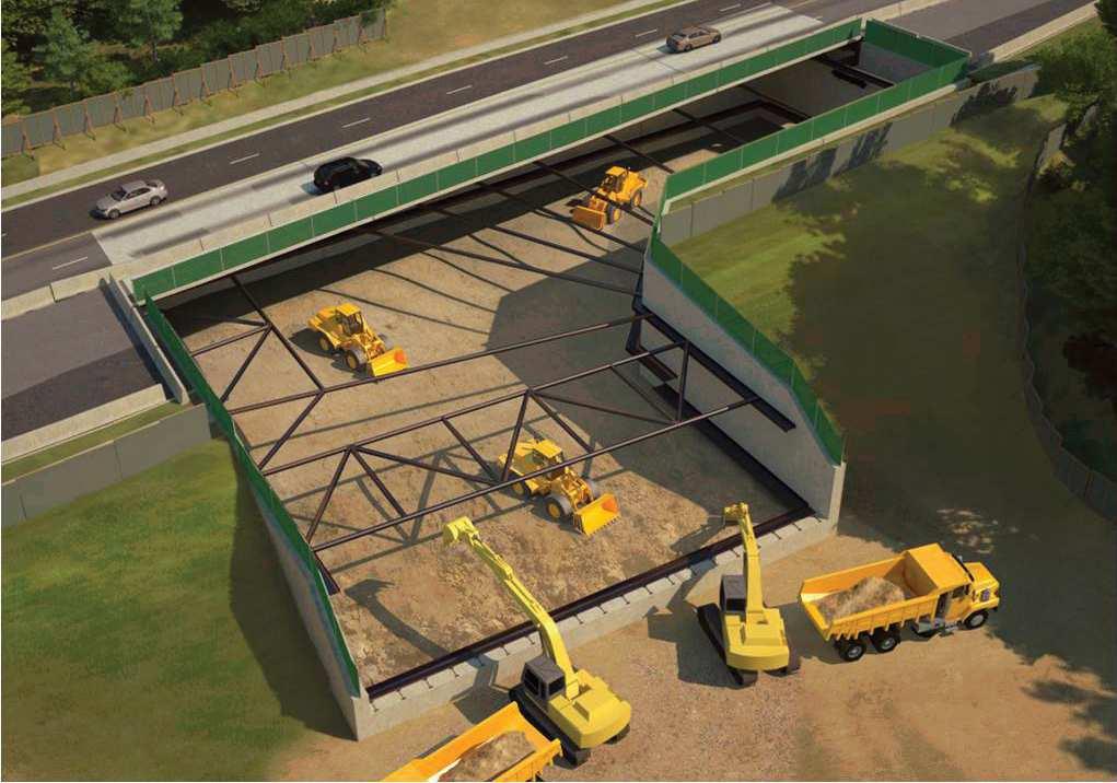
27 10 Western Alignment and Vehicle Maintenance and Storage Facility Consultation 2. Public Notification The following section lists the methods used to notify stakeholders and the public about the Western Alignment and Vehicle Maintenance and Storage Facility Consultation. Samples of the Canada Post drops and newspaper ads are included in Appendix A. 2.1 Canada Post Drops On June 15, 2012, 27,984 public notices for the open house and online consultation were delivered via Canada Post to properties within a 1.5 km radius of Black Creek Drive and Eglinton Avenue West. This included properties west of Jane Street and east to the railway tracks in the vicinity of Caledonia, both north and south of Eglinton. 2.2 Newspaper Ads On June 21, 2012, a newspaper ad was published in the York Guardian, reaching an estimated audience of more than 49, Comments Received: Vehicle Maintenance and Storage Facility The following is a compilation of comments received in both the Open House and the online consultation relating to the Vehicle Maintenance and Storage Facility. Comments and questions are grouped according to common themes. 3.1 Support I think it is a good site for the Vehicle Maintenance and Storage Facility. It's a good location in that it is adjacent to the Eglinton LRT line and fairly close to the proposed Jane LRT. 3.2 Safety and Accessibility It is most important to have accessibility through the lands (i.e. is anything shutting down).
28 It is important that the facility not be a barrier to accessing Weston station via bicycle, foot or vehicle. Ensure that the design does not create an unsafe zone for cycling and pedestrian traffic. Safety and fire are important considerations. Accessibility to the bus terminal - connectivity for pedestrians, removal of the wall, aesthetics, make it look green, make it blend with the environment. Questions About Safety and Accessibility (See Answers in Appendix C) Commuters from the north of Toronto could potentially park at the station and be downtown in 30 minutes Why no Parking? 3.3 Heritage It is important that the buildings somehow indicate that the land was home to Canada's film and cinema heritage during the 20th century. The history of the site is important. I would like to see the "Kodak" name be part of the Facility, for historical purposes. Restore and incorporate the original facade into the new Vehicle Maintenance and Storage Facility. It is important to keep and renovate the Kodak building. It is an important part of Mt. Dennis history. Seeing it vital again would mean a great deal. Keep the old Kodak building and use "Kodak" as part of name for the facility for historical purposes. 3.4 Economic Benefit/Impact It is important that the land is being used for employment/industrial purposes rather than being left derelict or being sold for condos. Bringing jobs to the community is important.
29 12 Western Alignment and Vehicle Maintenance and Storage Facility Consultation Its situation and associated links should not preclude the opportunity for future nearby residential, commercial, and industrial development. Disadvantaged community members should have access to jobs. Need uses that will provide local employment and held develop Mount Dennis. More employment opportunities would be much better than a mall. The storage facilities should not take up the entire lands. It is important to the community to have some of that land available for business, employment, retail, services, etc. Something that gives back to the community rather than a passage corridor through. If all the Kodak Lands are purely storage, services and transfers it will defeat the businesses as well. Creation of jobs at all levels. Projects associated with the redevelopment of the landscape are important. Questions About Economic Impact (See Answers in Appendix C) How will this improve the existing economy in the area? 3.5 Community Impact It's important that they are not disruptive to neighbours. It should be a community benefit and not a barrier. The station has to integrate within the rest of the community - it should serve the needs of Metrolinx/TTC, but it should not be a barrier to the neighbourhood. The facility should not adversely affect the community.
30 3.5 a) Noise Keep noise levels to minimum, no wheel squeal. Keep visual impact of site to minimum of residential area but have some area where activity is visible. Let useful work happen there. The facility should not detract from residents' enjoyment of their property (i.e. not noisy, not belching out toxic fumes). Noise pollution reduction is important. Block out the noises from LRT cars within the facility. Sound Barriers - ensuring sound of vehicular movement will not disrupt nearby residents (installation of sound proof wall structures). Build on the north part of the property and allow the south end for commercial/industrial uses. Noise mitigation, perhaps through the creation of natural barrier/ buffer between the facility and surrounding neighbourhood. 3.5 b) Traffic LRV access to site should not interfere with road traffic. Concern about potential increase in traffic because of LRT and/or increase in number of people working in the area. Have entrance for workers in a less-used area not Black Creek drive or Eglinton. Would prefer service yard to be further west, not in the Kodak lands. Ensure minimum Impact on traffic. 3.5 c) Land use That the facility does not consume the whole of the area and completely alters or overwhelms the space so it cannot be used for anything else. That it use as little land as possible so that other uses of the land are possible.
31 14 Western Alignment and Vehicle Maintenance and Storage Facility Consultation 3.6 Environmental Impact I have environmental/air concerns. Need pollution management to protect nearby green spaces and water once the facility is up and running. The plans for the TTC's Ashbridge Bay facility look great. They included environmentally friendly elements such as green roofs and tree planting. I hope that this facility would look beautiful instead of an old factory with tracks everywhere. Plant more trees and hide the tracks from view. The bank of the North of Eglinton Ave to be more environmentally friendly i.e. Instead of the cement wall, it would be good to have a more attractive landscaping, such as trees, rocks, etc. Minimal environmental impact. Questions About Environmental Impact (See Answers in Appendix C) How will Metrolinx/TTC lead with containing contamination in the neighbourhoods? 3.7 Cyclist Infrastructure Include bicycle infrastructure. Important that there be a bike storage/ locking area. Bicycle access - both to the facility and through the neighbourhood. Link facility and future Mt Dennis/Weston Road Station to bike paths and extend existing paths westward to Jane. 3.8 Facility Design It's very important that transit buildings are well designed not only to be attractive but also to use good materials that will last for many years.
32 Facility should be attractive. Make it a green building, consider grass between the outdoor tracks and landscaping. 3.8 a) Facility use Important that it takes into consideration future development in its design approach, and retain flexibility for soliciting future light commercial (no retail) industrial capability. Important that the buildings be attractive, utilitarian. Facility should have more than one purpose and built to LEED standards. Be effective with space to leave room for other green development. I would like to see the Kodak building retained for future redevelopment. Easy GO/LRT access would make this area very attractive for development. This is the best improvement made in the 2012 plan. How to address the Eglinton Avenue frontage, commercial and other cultural facilities (i.e.) Urban transit museum. Important to recreate a major transportation hub as was originally proposed with the Eglinton subway. 3.8 b) Retaining Wall I have worries about the retaining wall. Tear down that vile retaining wall on the north side of Eglinton. Open up the site to redevelopment wherever possible by removing retaining wall or moving it back. Make the site more attractive. 3.8 c) Fit in neighbourhood I want the new vehicle maintenance storage facility to fit in with the neighbourhood. My apartment-unit (for the past 22 years) faces at the old Kodak lands on oxford drive.
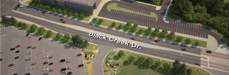
33 16 Western Alignment and Vehicle Maintenance and Storage Facility Consultation It should not stick out, it just fits in with the area buildings and green space. Should be not very visible from the street - buffer- noise mitigation. 4. Comments Received: Keele to Weston Road Alignment The following is a compilation of comments received in both the Open House and the online consultation relating to the preliminary alignment from Keele Street to Weston Road. Comments and questions are grouped according to common themes. 4.1 Project Support Long overdue! Looks good. It seems to make sense overall. I like that there is a stop at Weston Road-- it would have been too far east if it was only at Black Creek. I hope it goes to Jane Street or beyond! Looks great, much better than the on-street Weston Road stop shown during the Environmental Assessment in The new plan is much better than the old one. It is a good project for the future of our generation and our city. 4.2 Safety and Accessibility Recommend constructing an overhead walkway from the east end of the station to the east side of Black Creek Drive, providing convenient accessibility for commuters using both the new recreation centre and other facilities within park itself (reduce pedestrian danger/fatalities in/around wide intersection of Black Creek/Eglinton).
34 That is a massive realignment on Eglinton. The Weston and Eglinton Intersection is awkward now. The plan looks perfect. Elevated structure/underground is the only practical solution to crossing Black Creek and rail tracks. Use of the north side (off street) seems better than the centre of Eglinton. I have concerns about pedestrian access along Eglinton. Recreation centre needs to be more accessible from Keele Street and York Memorial Collegiate. If no LRT stop at Black Creek, must enhance pedestrian connections an safety between Keele and Weston Road. 4.3 Community Impact This alignment is much better than previous one. It keeps the west end of the line completely separated from traffic. This should improve service. Review and re-design the track alignment further north to allow for additional redevelopment opportunities and enhanced pedestrian connections. It should allow for development along the north side of Eglinton Ave. This would be a building barrier to sound. Above grounded portion must be designed with noise mitigation at the forefront. Again perhaps a natural buffer can be created between Eglinton and the LRT line. I like how LRT can avoid stopping at intersection red lights at Black Creek and Weston Road, leading to faster service and less traffic impact. 4.4 Underground vs. Above Ground Underground Weston/Mt. Dennis GO Station is good idea - ensure that easy pedestrian access to made for people.
35 18 Western Alignment and Vehicle Maintenance and Storage Facility Consultation Need more details at next consultation of how exactly Weston Road/Mt. Dennis Station is situated and accessed by pedestrians from Eglinton Avenue and high above from the Kodak site. It would be ideal to have the Eglinton LRT continue underground until Jane St due to traffic concerns at Eglinton and Black Creek and Eglinton and Weston Rd, as well as the inability to widen Eglinton in the vicinity of Weston Rd. Tunneling another 2-3 km to continue the LRT underground to almost Jane would present increased costs; however, it might be advisable to avoid the congestion problems being experienced at St. Clair West between Weston and Keele. Underground or separated from the road will avoid traffic congestion at Weston Rd. Ensure The Crosstown line is extended underground to west of the park entrance to Eglinton Flats so that cars can still access the park easily. Put the LRT underground from Keele St to Weston Rd. instead of the original proposal of above ground. The whole alignment should be underground. on both sides of the tracks. Would like to stay underground. Underground is great. It needs to be underground. Provide Recreation centre access at Black Creek underground. 4.5 Cycling Infrastructure Allowances should be made to accommodate a safe pathway for cyclists. Please look at the impact on existing and planned cycling infrastructure as you move forward. Bike lanes need to be included in the plans, along the entire length of road.
36 It's important that a complete streets approach be taken including bike lanes on Eglinton and cycling access to planned and existing off-road trails. I want to see design process to integrate safe cycling infrastructure along Eglinton, existing and planned bikeway routes connecting to Eglinton, and safe cycling approaches into the LRT stations. Please confirm how and which studies will address cycling concerns - the Alignment/Facility study, the Mobility Hub or the City Planning Eglinton Corridor Study. Concern about lack of a suitable bicycle infrastructure that would meet the Metrolinx requirements. It does not appear that cycling has been included in the preliminary plans. The impact on existing and planned cycling infrastructure needs to be considered even at this early stage. In particular, cycling routes along Eglinton, routes connecting to Eglinton, and cycling approaches into the LRT station(s) do not appear to have been considered in the preliminary design. Metrolinx Mobility Hub guidelines specify the inclusion of cycling infrastructure in the design of major transit nodes like the ones at Jane- Eglinton and Weston-Eglinton. 4.6 Community Participation Thanks for changing the plan from the old one. Consult early and involve community in land use decisions. Enjoy speaking 1 on 1 in depth with technical staff. At this time there is nothing that can be done by local residents to stop the Facility construction. Hold a town hall style meeting so politicians are given a chance to make public statements so they would have to be held accountable.
37 20 Western Alignment and Vehicle Maintenance and Storage Facility Consultation 4.7 Transit Expansion Why not underground all the way to Jane? The project should extend along Eglinton (above ground) to Weston Rd, As Eglinton is wide enough and above ground - it would save money. Keele to Weston Road route is under study, however that extension with the station at the intersection of Eglinton Ave & Weston Rd is essential because there are many people who take the TTC at that intersection. 4.8 Design I really like the elevated section over Black Creek drive. It s about time that we are looking long range. I would prefer not to see or hear the LRT. Natural buffer could help address this (perhaps in addition to a noise-reducing wall. This new alignment and station is better than not having a Weston Road Station but the station needs to be closer to Weston Road. The proposed new routes are not needed, use existing resources instead. The proposed routes going into the station at Black Creek need to be completely re-thought. Questions About Keele to Weston Road Alignment (See Answers in Appendix C) That is a massive realignment on Eglinton. How will it affect businesses and traffic afterwards? Eglinton dips down between Weston Rd and Black Creek, how will it be accessed on the south sides? How will the environmental assessment assess impact to green space at the Eglinton Flats? How will the maintenance yards be accessible, it appears the only way is by Black Creek Drive. Are there going to be additional entrances off of Eglinton?
38 From the drawing on page 18 of the presentation, what is the purpose of keeping part of Keelesdale Drive (north of Eglinton) open? Would it not be easier just to close the entire street? Why are you planning to build the LRT to Jane St if the Jane and Eglinton West Buses are going provide a connection to Mt. Dennis/Weston Road Station by stopping at the Kodak Site? Walk-in traffic from the uninhabited valley at Jane? With a bridge going over Black Creek Drive, will the incline of 5% (LRV specs) be maintained going from the Black Creek portal? When are you going to confirm the alignment west to Jane Street? Will the retaining wall on north side of Eglinton be removed or kept? 5. Comments Received: Neighbourhood and Additional Comments The following is a compilation of additional comments received in both the Open House and the online consultation. Comments and questions are grouped according to common themes. 5.1 Project Support/Opposition 5.1 a) Support This project might mean taking the subway/underground LRT far more often instead of my car. This project will be much needed boost for this area - and Toronto. The impact on this area is tremendous - we will finally feel truly part of the city and the car will no longer be a necessity. Very pleased to see the preliminary plans and look forward to seeing the final plans with a Mt Dennis station. Completion would make a commute to downtown a pleasure.
39 22 Western Alignment and Vehicle Maintenance and Storage Facility Consultation 5.1 b) Opposition The area needs more services, shopping, businesses, employment opportunities and overall revitalization, including of existing businesses. Not only is the facility a waste of prime land in a future prime location but, adds nothing of value to the community as a whole. It detracts from the community. 5.2 Transit Connections, Safety and Accessibility Ensure convenient and safe connection is provided to Community Centre at Black Creek Drive, particularly with no LRT stop there. I am concerned with no station at Black Creek to access community centre, not safe for kids to cross, transfer to #32 a concern. Provide easy transfer from Weston bus to both LRT station and future Go station. Safe access to the Mt. Dennis Station is vital. The previous plan put stops in a dangerous location in the middle of Weston Road. The 161 Rogers Road bus should use the Jane Stop as well, not Weston. The 89 Weston bus should not go into the Weston bus terminal, but stay on the street and allowing passengers to walk into the Weston station. The exits to the ground at Weston Rd & Eglinton Ave should be convenient for all directions. Planning, access, and ease to move from one mode of transportation to another is important. Connections with GO transit services are important. Parking and security (cameras) at stations are key concerns. Stations and alignment should not be designed in a way that cuts off natural/obvious connections to the community, forcing people to go in weird ways to access the stations. For example, even though the wall along Eglinton might be sparse and uninviting, there should still be access for pedestrians walking along it to get to these stations.
40 Concerned about how Jane Street buses will connect to the Crosstown and would like express Jane bus that continues south to Bloor. Ensure convenient and safe cycling connections to all stations and existing cycling routes (Keele to Jane). 5.3 Concerns with Timeline Speed it up! The timelines are way too long. I'd like it built yesterday. Build it fast. 1-2 years of really bad construction impacts is better than 5-6 years of some impact. Completing construction on schedule is most important. Most important is getting construction underway as quickly as possible. Important it gets done quick. Should be built as quickly as possible. Stop the delays and get started. I hope it is going to be built as fast as possible and the LRT is not slowed down by too many stops. Stop changing it, build it. 5.4 Economic Impact Job creation and barrier removal is most important to the neighbourhood. Provide Local employment in construction and then operations. Important that is attracts development/ intensification and amenities. Important that it attracts and improves the neighbourhood by bringing in substantial business. Good planning principle should be followed. Encourage business to relocate to the area (Weston Rd and Eglinton). Ensure Kodak lands include useful commercial or industrial space. 5.5 Community Impact The neighbourhood near Weston Rd must benefit from the addition of the Eglinton LRT as it will carry the burden of the LRT facility. The Hillcrest
41 24 Western Alignment and Vehicle Maintenance and Storage Facility Consultation complex is a good example of a facility that has minimal impact on the surrounding neighbourhood with attractive landscaping. Have minimum impact on the local businesses and keep the local community informed about the construction stages. Ensure that the community continues to be able to move and function. I'm not interested in very tall buildings cropping up along Eglinton. I would hope that city planning keeps in mind the neighbourhoods that they impact while they are redeveloping Eglinton. It's great they're creating jobs, but I hope they remember to think about how they impact the people that already live there. Develop around perimeter of Facility for noise containment. The land is too valuable for a maintenance/storage facility. 5.5 a) Existing transit Good foresight for further increased development of transit flow without negatively impacting adjacent neighbourhoods net value. Reduce the number of cars on Eglinton. Public Transit is the way to go. Get people walking again and fewer cars. Concerned that remaking of Jane Station will severely impact the Jane bus efficiency. I am concerned about the bus loop at the Kodak site. 5.5 b) Fit with neighbourhood Important that it keeps up with the changing community. Should not be a sore thumb industrial unit. Mixed used for the garage should be incorporated like the streetcar garages in the beach (Neville park) Davenport garage and the Coxwell bus depot. Important that this project brings our neighbourhood further up (i.e. makes it a more attractive place to live) and not down (i.e. makes it a place no one wants to live).
42 Important that the project will improve the Mt Dennis Area. I hope that the area will be attractive and it will bring pride and hope to the community. 5.5 c) Traffic Avoid traffic congestion as best as possible. Cut the area south bound on Keele to avoid traffic backup. 5.6 Environmental Impact Important to focus on environmental issues (dust containment, clean-up). 5.7 Complete Streets/Cyclist Infrastructure Bicycle routes and parking to enable transportation to and from stations and across Eglinton. Connected multimodal infrastructure that includes other wheeled transportation - notably bicycles and wheelchairs/scooters. The most important consideration is to rebuild Eglinton so it is safe and accessible for all road users - pedestrians, cyclists, transit users and drivers. Please consider cyclists as a key component in your plan moving forward. Less cars more bikes (and safe cycling routes) will reduce cars on the road, improve air quality, improve individual health (given cycling safety - which is why safe lanes are so important). I am concerned about an effective bicycle infrastructure where the LRT goes underground. It seems the healthiest, most environmental, sanest mode of transit has been ignored. Bike lanes have been in the official plan for years, not now,
43 26 Western Alignment and Vehicle Maintenance and Storage Facility Consultation Why? Why deprive an obese population the means to good health through an enjoyable, economical, best energy efficient means of travel? Just as in most of the world, a master plan for bikes must be included in all local plans including for Keele to Jane Street. Making room for all forms of transit - LRT pedestrians/bike/car drivers currently treat Eglinton from Jane to Keele like a highway. As a biker of commuter, a trail extension segregated bike lanes and or bike lanes at the very least would be a much appreciated side benefit of this project, which I will also ride as a transit rider. 5.7 a) Complete streets Bike lanes be incorporated, and follow a "complete streets" design. Any major transit project like this beginning in 2012 needs to take into account all modes of transit, including bicycles. Please take a "complete streets" approach and build in plans for easy transfer to cycle paths, preferably protected lanes. A "Complete Streets" approach to Eglinton will make the street it safer for all. As well, improving connections from the surrounding neighbourhoods to the transit stations, including for cyclists and pedestrians, would ensure the transit station serves and supports the community. The ultimate vision upon completion should be a truly complete street design that accommodates all vehicular and active transportation modes equally. 5.7 b) Metrolinx principles It is important that Metrolinx' mobility hub principles be employed throughout the design, implementation and operation of the facility. Most importantly, a complete streets approach that facilitates and encourages safe access by users of all modes of transportation in all age groups.
44 I am very excited about this project. Most important to me is that Metrolinx' Mobility Hub principles be followed throughout the project, especially those relating to complete streets for all users. 5.7 c) Cycling lanes I think that cycling lanes on Eglinton from Jane St. to Black Creek Dr. are an essential component of a successful Eglinton LRT transit project, preferably with a connection to the Metrolinx Mobility Hub. Please consider this as you move forward. Ensure safe cycling lanes, separated if possible. Important that cyclists have an exclusive, safe and accessible travel lane. Cycling is a key element of city planning and community health. We need lots of thought on creating a friendly environment for cycling along Eglinton, including bicycling lanes, routes and other infrastructure on Eglinton and around the LRT stations. This element appears to have been left out of the planning, despite Provincial and Municipal policies and instructions from Council to the contrary. This should be rectified. 5.8 Underground vs. Above Ground Weston Station should be underground and the tunnels going to the Eglinton Flats portal not disrupt the neighbourhood. To keep the whole alignment away from Eglinton Avenue and not take away any lanes, keep it underground! The whole Crosstown should be an underground proper subway, what a mistake by even considering street level sections. Underground Weston Road station is most important. The part of The Crosstown that comes above ground will be good for Eglinton Avenue. It will revitalize that very desolate stretch of Eglinton,
45 28 Western Alignment and Vehicle Maintenance and Storage Facility Consultation east of Victoria Park and will be good for local businesses as they will be visible to people and they can hop on and off the streetcar. The Sheppard subway looks like it has been a boon to small local businesses from Yonge to Don Mills. Had that stretch of transit been streetcar instead, it would have kept people above ground and they would have been more aware of the neighbourhoods and local businesses around them and able to hop on and off easily. Make underground alignment west of Eglinton Flats park entrance so residents can turn left to access it. 5.9 Community Involvement Most important for our neighbourhood is public input. Important that citizens (both locally and across Toronto) be fairly incorporated in the decision-making process. Community involvement! I recommend developing a program that works with youth in/around area to increase both their interest and participation in this forever changing transit growth. 5.9 a) Consultations The public consultations are very important and keep the public well informed while continuing to foster support. Although the Eglinton line is a welcome addition it must be seen as part of the overall network for the city and greater efforts must be made by the TTC and city council to integrate it as part of a larger network beyond that which is already built. There should have been an open house on Weston Road to include the Mt. Dennis/Weston community since there is a bulk of the changes happening and talk about the EA to Jane St. How this will impact businesses, residents all the other stations have had open houses but this one seems missed.
46 Host more consultations on the design, Discussions about girdling jobs to priority neighbourhood, green investment and economic development. It is important that neighbourhood groups be allowed to work together with architects and engineers to come up with additional solutions to construction problems in their neighbourhood. 5.9 b) Communications Communications need to be effective on a city-level, and the process needs to be as participatory as possible (and not just a weak attempt). Being kept up to date on developments and additions to the plan is important. Keep the lines of communication open between the public and the construction process. Ensure people are well informed and that negative talk is anticipated and proactively dealt with. Social Media: there must be an increased use of social media in order to reach every/all members of the communities affected and participating in the making of The Crosstown. I recognize the FB/Twitter links but the presence online can be stronger Transit Expansion I hope that The Eglinton-Scarborough Crosstown will connect with Jane St. for the proposed LRT there, and eventually get its way to Pearson Airport. The proposed Airport Rail Link is designed for business elites with no thought to how normal Torontonians use transit. Finalize plan to end at Weston (or Jane), underground to exit above ground just east of Jane is best option going forward can be put off if the funds are not available and end at Weston instead in the interim.
47 30 Western Alignment and Vehicle Maintenance and Storage Facility Consultation 5.11 Surrounding Streets Shifting Mt. Dennis Station eastward is important. Jane Street is where the 401 and the 400 empty into City Traffic, this needs to be addressed. We need a connection from LRT to Weston Road Bus, a covered walkway from the LRT. Jane is the natural western terminus of the Eglinton Line General Design Perhaps engage the community and invite artists to paint these areas with murals or something could make these spaces less desolate. Keep long term impact to minimum. Design stations so that they can be integrated into new development. You are going to be building all these stations, incorporate some affordable seniors housing within the build. I would like to suggest that the landscaping around The Crosstown is kept a very high priority. No bus connection for Mt. Dennis station if at rail road tracks, should put at Weston Station being away from Weston Road will cause inconvenience for pedestrians. The area fronting on the south side of Industry Street and the east side of Ray Avenue as I saw in the plans was to be open to the street, showing off the unsightly rail yard and thus ruining Industry street and devaluing the area which is a very nice street in an up and coming area. The office complex you have designed to be in the east side of the rail maintenance yard should be relocated to be a series of three or four story buildings built along Industry Street and Ray Avenue to block the sight lines of the rail yard behind, thus preserving and hopefully enhancing the streetscape on Ray and Industry instead of destroying it.
48 Please leave all the large mature trees in this area. Your map showed a concrete wasteland of parking and rail yards without trees. The parking lots themselves, left unshaded will produce a great deal of heat and dust. The parking lots should be behind the buildings on the newly created office buildings that line the south side of Industry St., and the east side of Ray Avenue. General Questions (See Answers in Appendix C) We still have not heard about the impact to surface bus routes along Eglinton and the connecting routes in the area. How much communication is being done with the TTC on this? What will be the property impact to the Daycare? Will there be a Jane LRT Connection? Will there be any changes/impacts to York Memorial Collegiate? Concerned about noise decibel levels on turning, how far will the noise reach (especially west)? What is the exact level? Why northern storm water pond what's the purpose? Why do we want a GO station at Eglinton?

49 32 Western Alignment and Vehicle Maintenance and Storage Facility Consultation Appendix A

50 Appendix B

51 34 Western Alignment and Vehicle Maintenance and Storage Facility Consultation
52
53 36 Western Alignment and Vehicle Maintenance and Storage Facility Consultation
54 Appendix C Eglinton-Scarborough Crosstown Western Alignment and Vehicle Maintenance and Storage Facility Consultation Questions Q: Will you re-design the Facility to add commuter parking? Commuters could be downtown in a very short time from the Kodak Site. A: There is limited space available within the Kodak Site. The primary focus is on providing excellent customer connections to TTC surface bus routes and for pedestrians and cyclists in the community. The design protects for a future connection to GO Transit to serve commuters. Q: How will the Crosstown and Vehicle Maintenance and Storage Facility improve the existing economy in the area? A: The GTHA s quality of life and economic well-being especially the maintenance and creation of jobs depends on a robust, reliable and modern regional transportation system that will keep Toronto and the entire region moving now and well into future. The Eglinton-Scarborough Crosstown LRT will help create jobs and economic benefits, including in the Mount Dennis community and at the MSF itself once the facility is operational. It will provide transit riders with a fast, frequent and reliable alternative to traveling across the city, while a light rail station at Eglinton and Weston Road will provide better local transit, including fast and convenient access to the Spadina and Yonge subway lines. The Kodak Lands are essential to the Eglinton-Scarborough Crosstown LRT project and are of course important to the local community. Further community consultation will take place later this year as part of the Environmental Assessment. Metrolinx is conducting a Mobility Hub Study for the area around the new Weston Rd/Mt Dennis station, which is now in its beginning stages. Mobility hubs are places where different modes of transportation come together seamlessly and act as locations for employment, amenities, and services. In the case of the Weston Rd/Mount Dennis station, the Metrolinx Mobility Hub Study will investigate, in a roughly 800-metre area around the station, such factors as pedestrian and cycling connections to the station, opportunities to enhance the public realm in the station area and opportunities for transit-oriented development in the surrounding area. A Mobility Hub Workshop with the community is anticipated in the fall.
55 38 Western Alignment and Vehicle Maintenance and Storage Facility Consultation Q: How will Metrolinx contain contamination from the Kodak Site? A: It is currently proposed to remove 1m of soil from the upper tier of the site. This would be replaced with a capping layer of clean fill. A geotechnical study is currently underway on the site to evaluate the current soil conditions and make recommendations for design. When this study is complete, the recommendations will be incorporated into the design of the facility. Soil that is removed will be disposed according to Ministry of the Environment guidelines. Q: There may be a big re-alignment on Eglinton. How will the alignment plans affect businesses and traffic afterward implementation? A: The preliminary plan would separate the LRT from traffic at Eglinton and Black Creek to provide a seamless transit connection to the Maintenance and Storage Facility and eliminate potential traffic impacts at Black Creek Drive. Any potential re-alignments of Eglinton between Keele Street and Jane Street will be evaluated during the Transit Project Assessment study which is scheduled to begin in Fall, Q: Eglinton dips down between Weston Road and Black Creek, how will I get to the Mt Dennis/Weston Road station from the south side? A: Options to access the site from the south side of Eglinton Avenue are under investigation. Two accesses to the Weston Road/Mount Dennis LRT Station will be provided from the north side of Eglinton Avenue both east and west of the rail corridor, and will be accessed by the existing sidewalk system, with signalized crossings of Eglinton Avenue at the Weston Road and Black Creek Drive intersections. Additionally, the Project Team is reviewing opportunities to use the existing Photography Drive structure in the future to provide a pedestrian connection to the lands occupied by the No Frills development.
Submission to Metrolinx on Eglinton LRT - East End. Response to December 2012 Public Meeting
 Submission to Metrolinx on Eglinton LRT - East End Project Response to December 2012 Public Meeting Prepared by: Cycle Toronto, cycleto.ca Authors: John Taranu, Michael Black January 21, 2013 1 Introduction
Tonight is for you. Learn everything you can. Share all your ideas.
 Strathcona Neighbourhood Renewal Draft Concept Design Tonight is for you. Learn everything you can. Share all your ideas. What is Neighbourhood Renewal? Creating a design with you for your neighbourhood.
DON MILLS-EGLINTON Mobility Hub Profile
 Mobility Hub Profile Dundas Don Mills-Eglinton West-Bloor Anchor Hub Gateway Hub N MOBILITY HUBS: Places of connectivity between regional and rapid transit services, where different modes of transportation
Appendix 1 Transit Network Analysis
 Appendix 1 Transit Network Analysis APPENDIX 1 TRANSIT NETWORK ANALYSIS The purpose of this appendix is to provide an update on the transit network analysis as it pertains to: i. SmartTrack ii. Scarborough
Transportation Assessment
 Transportation Assessment Midtown Open House February 10, 2018 Overview Midtown in Focus Overview & Purpose of Today Transportation Assessment overview Summary of Transportation work to date Review & Analysis
Comments The Plan for Port Whitby
 Comments The Plan for Port Whitby April 24th, 2013 Community Meeting #2 Summary Report Prepared by GLPi April 29th, 2013 1 Introduction The purpose of the Port Whitby Secondary Plan Update, Community Improvement
McKenzie Interchange Project Fall 2015 Engagement. Appendix 2: Engagement Materials and Feedback Form
 Fall 2015 Engagement Appendix 2: Engagement Materials and Feedback Form Welcome to the McKenzie Interchange Project Open House! Purpose of Open House To provide you with information regarding the project
CONNECTING PEOPLE TO PLACES
 CONNECTING PEOPLE TO PLACES 82 EAST BENCH MASTER PLAN 07 Introduction The East Bench transportation system is a collection of slow moving, treelined residential streets and major arteries that are the
NEWMARKET CENTRE Mobility Hub Profile
 Mobility Hub Profile Dundas Newmarket West-Bloor Centre Anchor Hub Gateway Hub N MOBILITY HUBS: Places of connectivity between regional and rapid transit services, where different modes of transportation
AIRPORT ROAD ENVIRONMENTAL ASSESSMENT
 WELCOME TO PUBLIC INFORMATION CENTRE #1 AIRPORT ROAD ENVIRONMENTAL ASSESSMENT From Braydon Boulevard/Stonecrest Drive to Countryside Drive November 23, 2017 6:30 PM 8:30 PM Please sign in and fill out
TRAVEL PLAN: CENTRAL EUROPEAN UNIVERSITY CAMPUS REDEVELOPMENT PROJECT TRAVEL PLAN. Central European University Campus Redevelopment Project.
 TRAVEL PLAN Central European University Campus Redevelopment Project Page 1 Table of Contents Introduction... 3 Background... 7 Building Users... 7 Transportation in Community Consultation... 7 Summary
Southwest Bus Rapid Transit (SW BRT) Functional Planning Study - Executive Summary January 19 LPT ATTACHMENT 2.
 Functional Planning Study - Executive Summary January 19 LPT ATTACHMENT 2.") Southwest Bus Rapid Transit (SW BRT) Functional Planning Study - Executive Summary 2011 January 19 1 of 19 Introduction This executive summary presents the results of the Southwest Bus Rapid Transit (SW
Southwest Bus Rapid Transit (SW BRT) Functional Planning Study - Executive Summary 2011 January 19 1 of 19 Introduction This executive summary presents the results of the Southwest Bus Rapid Transit (SW
EXECUTIVE SUMMARY: TRANSIT-ORIENTED DEVELOPMENT IN SMITHS FALLS, ONTARIO; A COMPARISON BETWEEN TWO SITES
 EECUTIVE SUMMARY: TRANSIT-ORIENTED DEVELOPMENT IN SMITHS FALLS, ONTARIO; A COMPARISON BETWEEN TWO SITES Topic and Purpose In 2007, the Mayor of Ottawa s Task Force on Transportation suggested adding a
DON MILLS-SHEPPARD Mobility Hub Profile
 DON MILLS-SHEPPARD Mobility Hub Profile Dundas Don Mills-Sheppard West-Bloor Anchor Hub Gateway Hub N MOBILITY HUBS: Places of connectivity between regional and rapid transit services, where different
Eglinton West/Allen Road Station Preliminary Design Online Consultation
 Eglinton West/Allen Road Station Preliminary Design Online Consultation Feb 2, 2012 Feb 17, 2012 2/3/2012 2/3/2012 2 Online Consultation Overview Part 1 Introduction Crosstown Update Station Design 101
Building a Toronto that Moves
 Building a Toronto that Moves Image courtesy of the City of Toronto Setting Election Priorities for Walking, Cycling & Public Transit Toronto is a fast-paced, dynamic city. It s a city that moves except
WELCOME TO OPEN HOUSE # 1 June 14, 2017
 Langstaff Road Weston Road to Highway 7 Class Environmental Assessment Study WELCOME TO OPEN HOUSE # 1 June 14, 2017 Please sign in and join our mailing list Purpose of Open House #1 & Study Area York
Transportation Master Plan Advisory Task Force
 Transportation Master Plan Advisory Task Force Network Alternatives & Phasing Strategy February 2016 BACKGROUND Table of Contents BACKGROUND Purpose & Introduction 2 Linking the TMP to Key Council Approved
COUNCIL POLICY NAME: COUNCIL REFERENCE: 06/119 06/377 09/1C 10llC 12/1C INDEX REFERENCE: POLICY BACKGROUND
 COUNCIL POLICY NAME: COUNCIL ADVISORY COMMITTEES - TERMS OF REFERENCE ISSUED: APRIL 3, 2006 AMENDED: NOVEMBER 27, 2006 NOVEMBER 23, 2009 JANUARY 11, 2010 DECEMBER 17, 2012 POLICY COUNCIL REFERENCE: 06/119
Welcome to the McKenzie Interchange Project Open House!
 Welcome to the McKenzie Interchange Project Open House! Purpose of Open House To provide you with information regarding the project and for you to have the opportunity to share your input on design concepts.
Chapter 7. Transportation. Transportation Road Network Plan Transit Cyclists Pedestrians Multi-Use and Equestrian Trails
 Chapter 7 Transportation Transportation Road Network Plan Transit Cyclists Pedestrians Multi-Use and Equestrian Trails 7.1 TRANSPORTATION BACKGROUND The District of Maple Ridge faces a number of unique
City of Toronto Complete Streets Guidelines
 Round One This is a summary of the Complete Streets Guidelines Survey posted on June 18 th, 2015 and live until July 2 nd, 2015. The survey was designed to solicit feedback on the draft Complete Streets
Frequently Asked Questions (FAQ)
") Frequently Asked s (FAQ) Study Process... 2 Rapid Transit Service and Operations... 5 Public Consultation... 8 Business Impacts... 8 Design and Property Impacts... 9 Construction Impacts...12 Traffic,
Frequently Asked s (FAQ) Study Process... 2 Rapid Transit Service and Operations... 5 Public Consultation... 8 Business Impacts... 8 Design and Property Impacts... 9 Construction Impacts...12 Traffic,
EXECUTIVE SUMMARY. Vision
 Vision Walking and bicycling in Salt Lake City will be safe, convenient, comfortable, and viable transportation options that connect people to places, foster recreational and economic development opportunities,
A CHANGING CITY. of Edmonton, it is essential that it reflects the long-term vision of the City.
 A CHANGING CITY By the year 2040, Edmonton will be home to more than 1 million people. To accommodate growth and support a healthy and compact city, we need a new approach to development/redevelopment
TORONTO TRANSIT COMMISSION REPORT NO.
 Revised: March/13 TORONTO TRANSIT COMMISSION REPORT NO. MEETING DATE: January 28, 2014 SUBJECT: IMPROVING PEDESTRIAN SAFETY AND CUSTOMER JOURNEY TIMES: TRANSIT STOPS ACTION ITEM RECOMMENDATIONS It is recommended
Governance and Priorities Committee Report For the July 2, 2015 Meeting
 CITY OF VICTORIA For the July 2, 2015 Meeting To: Governance and Priorities Committee Date: From: Subject: Brad Dellebuur, A/Assistant Director, Transportation and Parking Services Executive Summary The
TRANSPORTATION NEEDS ASSESSMENT
 TRANSPORTATION NEEDS ASSESSMENT A travel demand analysis was carried out to determine the operational issues and the potential benefit that adding traffic capacity would have on the road network. All the
Mumford Terminal Replacement Opportunities Neighbourhood Open House. we are here. PHASE 2 Identifying and Evaluating Candidate Sites
 Welcome Replacement Opportunities Neighbourhood Open House. AGENDA PURPOSE 1. REVIEW the information boards 2. DISCUSS aspects of the project with the project team 3. SHARE your thoughts on replacement
21.07 TRANSPORT CONNECTIVITY AND INFRASTRUCTURE
 21.07 TRANSPORT CONNECTIVITY AND INFRASTRUCTURE 21.07-1 Connectivity and Choice Transport connectivity and mode choice are critical to achieving productive, sustainable and socially just cities. Travel
Light Rail Transit in North Central Calgary Open House and Workshop Summary. Summer 2013
 Light Rail Transit in North Central Calgary Open House and Workshop Summary Summer 2013 Engaging Calgarians on NC LRT The City of Calgary is working to improve transportation choices that will connect
DUNDAS WEST-BLOOR Mobility Hub Profile
 Mobility Hub Profile Dundas West-Bloor Anchor Hub Gateway Hub N MOBILITY HUBS: Places of connectivity between regional and rapid transit services, where different modes of transportation come together
APPENDIX 2 LAKESHORE ROAD TRANSPORTATION REVIEW STUDY EXECUTIVE SUMMARY
 APPENDIX 2 LAKESHORE ROAD TRANSPORTATION REVIEW STUDY EXECUTIVE SUMMARY Appendix 2 City of Mississauga Lakeshore Road FINAL REPORT Transportation Review Study December 2010 EXECUTIVE SUMMARY Study Purpose
CITY OF VAUGHAN EXTRACT FROM COUNCIL MEETING MINUTES OF OCTOBER 30, 2012
 CITY OF VAUGHAN EXTRACT FROM COUNCIL MEETING MINUTES OF OCTOBER 30, 2012 Item 31, Report No. 39, of the Committee of the Whole, which was adopted without amendment by the Council of the City of Vaughan
PEDESTRIAN ACTION PLAN
 ATTACHMENT 2 CITY OF SANTA MONICA PEDESTRIAN ACTION PLAN CITY OF SANTA MONICA PEDESTRIAN ACTION PLAN This page intentionally left blank EXECUTIVE SUMMARY CHAPTER 1 EXECUTIVE SUMMARY Setting the Stage
NORTH YORK CENTRE Mobility Hub Profile
 Mobility Hub Profile Dundas North York West-Bloor Centre Anchor Hub Gateway Hub N MOBILITY HUBS: Places of connectivity between regional and rapid transit services, where different modes of transportation
Public Event 1 Community Workshops
 Public Event 1 Community Workshops Nov. 24 & Dec. 3, 2016 Welcome Workshop Purpose We re looking to you for ideas and insights to help guide future transportation infrastructure planning in the Park Lawn
Appendix A-K Public Information Centre 2 Materials
 Appendix A-K Public Information Centre 2 Materials Our Rapid Transit Initiative Make an impact on the future of transit Join the discussion on Rapid Transit in London You re invited to a Public Information
The following notes describe comments received that were written/drawn on maps by workshop participants.
 Stakeholder Workshop Additional Feedback Received Maps and Comment Forms October 5, 2016 The following notes describe comments received that were written/drawn on maps by workshop participants. MAP 1 MAP
WELCOME. Purpose of the Open House. Update you on the project. Present a draft recommended plan. Receive your input
 WELCOME Purpose of the Open House The Town of Smiths Falls has initiated the Beckwith Street Redevelopment Plan that includes the preparation of a streetscape functional design for the renewal of Beckwith
Building a Liveable Ottawa 2031 Backgrounder 5: Barrhaven/Riverside South/Leitrim
 Building a Liveable Ottawa 2031 Backgrounder 5: Barrhaven/Riverside South/Leitrim Wards 3 and 22 Official Plan Transportation Master Plan Cycling Plan Pedestrian Plan October 2013 ottawa.ca/liveableottawa
Markham Sports, Entertainment and Cultural Centre Transportation Overview
 Markham Sports, Entertainment and Cultural Centre Transportation Overview ARENA LOCATION 2 3 TRANSPORTATION VISION IN MARKHAM On April 12, 2011, Markham Council adopted a long-term Transportation Vision
Climate Change Action Plan: Transportation Sector Discussion Paper: Cycling
 Climate Change Action Plan: Transportation Sector Discussion Paper: Cycling ontario.ca/climatechange Contents 1. Minister of Transportation s message... 3 2. Introduction... 5 3. Sector Overview and Support
Moving Cambridge. City of Cambridge Transportation Master Plan Public Consultation Centre. March 7, :00 8:00 PM.
 City of Cambridge Transportation Master Plan Public Consultation Centre March 7, 2018 5:00 8:00 PM Region of Waterloo City of Cambridge Transportation Master Plan Public Consultation Centre March 7, 2018
Cherry Creek Transportation and Land Use Forum September 25, 2013 Meeting Summary
 Cherry Creek Transportation and Land Use Forum September 25, 2013 Meeting Summary I. LEAD-IN TO SMALL GROUP DISCUSSION, POLLING AND STEERING COMMITTEE/TECHNICAL TASK FORCE DISCUSSION The meeting began
Public Information Centre
 WELCOME Public Information Centre Father Tobin Road Lougheed Middle School - Library Wednesday November 7, 2012 7:00 p.m.to 9:00 p.m. Please sign in Neighbourhood Traffic Calming Guide Background The City
North Coast Corridor:
 North Coast Corridor: Connecting People, Transportation & Environment Legislative Hearing: 11.8.10 1 North Coast Corridor Region s Lifeline A Regional Strategy Mobility, Economy & Environment North Coast
TORONTO WALKING STRATEGY
 CITY OF TORONTO t TORONTO WALKING STRATEGY EVERYONE IS A PEDESTRIAN ItitiORONM TORONTO MAYOR DAVID MILLER Toronto's Walking Strategy is a vision for a more liveable, prosperous and sustainable city. It
Exhibit 1 PLANNING COMMISSION AGENDA ITEM
 Exhibit 1 PLANNING COMMISSION AGENDA ITEM Project Name: Grand Junction Circulation Plan Grand Junction Complete Streets Policy Applicant: City of Grand Junction Representative: David Thornton Address:
2. Context. Existing framework. The context. The challenge. Transport Strategy
 Transport Strategy Providing quality connections Contents 1. Introduction 2. Context 3. Long-term direction 4. Three-year priorities 5. Strategy tree Wellington City Council July 2006 1. Introduction Wellington
York Region Population and Employment Growth
 March 1, 2016 1 York Region Population and Employment Growth York Region needs to comply with The Provincial Growth Plan and new forecasts introduced to 2036 and 2041 2 Regional Official Plan Review York
City of Novi Non-Motorized Master Plan 2011 Executive Summary
 City of Novi Non-Motorized Master Plan 2011 Executive Summary Prepared by: February 28, 2011 Why Plan? Encouraging healthy, active lifestyles through pathway and sidewalk connectivity has been a focus
Chapter 5. Complete Streets and Walkable Communities.
 Chapter 5. Complete Streets and Walkable Communities. 5.1 Description of Complete Streets. Cities throughout the world, and specifically the United States, are coming to embrace a new transportation and
Pattullo Bridge Replacement Project Community Connections Phase 2 Consultation. Appendix 3: Open House Display Boards
 Replacement Project Community Connections Phase 2 Consultation Appendix 3: Open House Display Boards November 2016 Welcome! Welcome to the Replacement Project Public Open House We Want to Hear from You
Tuesday, September 25 th Mount Holly Municipal Complex 400 East Central Avenue 5:30pm to 7:30pm. Activity Stations o Where do you Live?
 Meeting Information Overview The public workshop for the Mount Holly Comprehensive Bicycle Plan occurred on September 25, 2018. The drop-in workshop allowed attendees to participate in a series of interactive
Active Transportation Infrastructure Investment A Business Case
 Active Transportation Infrastructure Investment A Business Case In 2016, the Real Estate Foundation awarded the Capital Regional District a $50,000 grant for Shifting Gears: Land Use Change through Active
Hamilton Transportation Master Plan Public Consultation. Public Information Centre One Summary
 Hamilton Transportation Master Plan Public Consultation Public Information Centre One Summary Table of Contents Introduction 1 Purpose 2 What Was Presented 2 Who Came to the Meeting 2 The Breakout Sessions
STONY PLAIN ROAD STREETSCAPE
 Jasper Place Revitalization Strategy: Vision The people involved in the Jasper Place Revitalization Strategy envision: Goal 1: Feeling safe in our community Create a community where feeling safe is common--where
Tonight is an opportunity to learn about the Study and ask questions of the Study Team members.
 Exhibit 1 Welcome Second Open House Tonight is an opportunity to learn about the Study and ask questions of the Study Team members. A first Public Open House was held on September 18th, 2013 which presented
Regional Transportation Needs Within Southeastern Wisconsin
 Regional Transportation Needs Within Southeastern Wisconsin #118274 May 24, 2006 1 Introduction The Southeastern Wisconsin Regional Planning Commission (SEWRPC) is the official areawide planning agency
McKenzie Interchange Project Spring 2016 Comment Period. Appendix 1: Display Boards and Feedback Form
 McKenzie Interchange Project Spring 2016 Comment Period Appendix 1: Display Boards and Feedback Form August 2016 Welcome to the McKenzie Interchange Project Information Session! Purpose of this Information
Winnipeg Walk Bike Projects Downtown Tire Talk - Summary
 Winnipeg Walk Bike Projects Downtown Tire Talk - Summary Downtown Projected Bike Lane System Connecting The Forks to the Exchange District (Fort Street, Garry Street & The Forks to Assiniboine Connection)
CLOSED. The draft concept design has been broken down into 5 categories for the purpose of this survey:
 Old Strathcona s neighbourhood renewal process is now at the draft concept design phase. Over the last several months, the city has been gathering local knowledge and resident input that has been used
Update June 2018 OUR 2017 PUBLIC ENGAGEMENT
 Update June 2018 Hi, Let s Get Wellington Moving (LGWM) is developing a Recommended Programme of Investment (RPI) that meets our programme objectives and supports the city s and region s growth. As part
Chapter 2. Bellingham Bicycle Master Plan Chapter 2: Policies and Actions
 Chapter 2 Bellingham Bicycle Master Plan Chapter 2: Policies and Actions Chapter 2: Policies and Actions The Bicycle Master Plan provides a road map for making bicycling in Bellingham a viable transportation
Nanaimo Transportation Master Plan. Phase 1 Consultation Summary
 Nanaimo Transportation Master Plan Phase 1 Consultation Summary Transportation Advisory Committee Meeting Wednesday December 12, 2012 Agenda Study Update Phase 1 Consultation Process Phase 1 Consultation
Pennsylvania Avenue (CR 484) Design Alternatives Study
 Design Alternatives Study") MEMORANDUM Pennsylvania Avenue (CR 484) Design Alternatives Study Prepared for: APRIL 2016 Prepared By TABLE OF CONTENTS Project Background... 2 Previous Concept... 2 Existing Conditions... 4 New Alternatives...
MEMORANDUM Pennsylvania Avenue (CR 484) Design Alternatives Study Prepared for: APRIL 2016 Prepared By TABLE OF CONTENTS Project Background... 2 Previous Concept... 2 Existing Conditions... 4 New Alternatives...
Bicycle Master Plan Goals, Strategies, and Policies
 Bicycle Master Plan Goals, Strategies, and Policies Mobilizing 5 This chapter outlines the overarching goals, action statements, and action items Long Beach will take in order to achieve its vision of
1.1 Study Purpose. 1.2 Study Area 1. INTRODUCTION AND STUDY PROCESS
 1. INTRODUCTION AND STUDY PROCESS The City of Toronto has undertaken a number of studies and initiatives pertaining to the cost-effective expansion of transit as a means of making Toronto a more liveable
Perryville TOD and Greenway Plan
 Perryville TOD and Greenway Plan Greenway Glossary Pathway: A bicycle and pedestrian path separated from motorized vehicular traffic by an open space, barrier or curb. Multi-use paths may be within the
Illustrated Principles of Good Planning
 Illustrated Principles of Good Planning The Miami 21 Zoning Code incorporates time-tested planning principles into the zoning regulations of our City. These are principles that make for better neighborhoods,
Bikeway action plan. Bicycle Friendly Community Workshop March 5, 2007 Rochester, MN
 Bikeway action plan Summary The was held on March 5, 2007 at the Rochester Mayo Civic Center. The workshop was hosted by Rochester-Olmsted County Planning Department in collaboration with the League of
HAMILTON BIKING PLAN OUR VISION: A BIKE FRIENDLY CITY
 HAMILTON BIKING PLAN 2015-2045 OUR VISION: A BIKE FRIENDLY CITY INTRODUCTION Biking as a travel option is experiencing a resurgence internationally and in New Zealand, growing as a familyfriendly and healthy
Ann Arbor Downtown Street Plan
 1 Ann Arbor Downtown Street Plan Public Workshop #1 We know that. 2 Public right-of-way (streets, sidewalks, and alleys) make up 30% of the total District area of downtown. Streets need to provide mobility
Complete Streets: Policy Framework Complete Streets: Implementation Plans A more Complete Street: Laurier Bike Lane Pilot Project
 Complete Streets Initiatives City of Ottawa Complete Streets: Policy Framework Complete Streets: Implementation Plans A more Complete Street: Laurier Bike Lane Pilot Project Zlatko.Krstulic@Ottawa.ca May
Building a Liveable Ottawa 2031 Backgrounder 4: Kanata/Stittsville
 Building a Liveable Ottawa 2031 Backgrounder 4: Kanata/Stittsville Wards 4, 6 and 23 Official Plan Transportation Master Plan Cycling Plan Pedestrian Plan October 2013 ottawa.ca/liveableottawa Building
LEA BRIDGE ROAD - A STREET FOR EVERYONE Public consultation document
 LEA BRIDGE ROAD - A STREET FOR EVERYONE Public consultation document TELL US Bakers Arms to Leyton Green Road (Section D, E, F) Leyton Green Road to Whipps Cross Roundabout (Section G) YOUR VIEWS www.enjoywalthamforest.co.uk
Scarlett Road Bridge & Road Improvements Lambton Park Community School - Gymnasium Tuesday November 28 th, 2017
 Scarlett Road Bridge & Road Improvements Lambton Park Community School - Gymnasium Tuesday November 28 th, 2017 PROJECT LOCATION 2 SCARLETT ROAD BRIDGE Constructed in 1912, the bridge carries 4 active
Wyldewood Estates. Pre-Application Public Engagement Summary of Issues and Responses
 Wyldewood Estates Pre-Application Public Engagement Summary of Issues and Responses March 2016 Executive Summary Morguard Residential Properties has been thoughtfully planning the redevelopment of Wyldewood
University of Victoria Campus Cycling Plan Terms of Reference. 1.0 Project Description
 University of Victoria Campus Cycling Plan Terms of Reference 1.0 Project Description The Campus Cycling Plan, a first for the University, will provide a comprehensive and coordinated approach to support
2014/2015 BIKE ROUTE PLAN 83 AVENUE PROTECTED BIKE LANE
 About the Project 2014/2015 BIKE ROUTE PLAN The City of Edmonton is planning a major bike route on the south side of Edmonton. This bike route is one part of a plan to provide citizens with transportation
City of Sammamish. Welcome. Issaquah-Fall City Road Improvements Project Phase I Design: 242nd Avenue SE to Klahanie Drive SE
 Welcome Welcome to the third community meeting for the Issaquah-Fall City Road Improvements Project. AGENDA 6:00 p.m. Welcome and sign-in 6:10 p.m. Presentation 6:50 p.m. Open house Learn about the roadway
WELCOME. City of Greater Sudbury. Transportation Demand Management Plan
 WELCOME City of Greater Sudbury Transportation Demand Management Plan Public Consultation Session St. Andrew s Place, Activity Hall 111 Larch Street Wednesday September 13, 2017 6:00 to 8:00 pm Welcome
Vision: Traditional hamlet with an attractive business/pedestrian friendly main street connected to adjacent walkable neighborhoods
 N D. Focus Area II Vision: Traditional hamlet with an attractive business/pedestrian friendly main street connected to adjacent walkable neighborhoods Transit Road Focus Area II is located in the Hamlet
Reflections on our learning: active travel, transport and inequalities
 Reflections on our learning: active travel, transport and inequalities Jill Muirie Glasgow Centre for Population Health Active travel definition Active travel refers to walking, cycling or using some other
Sixth Line Development - Transit Facilities Plan
 Memorandum Date: November 13, 2012 To: From: c.c. Subject: Rob Freeman (Freeman Planning) Kevin Phillips Sixth Line Development - Transit Facilities Plan 33016631 This memo was prepared to review the transit
CONNECTIVITY PLAN. Adopted December 5, 2017 City of Virginia Beach
 CONNECTIVITY PLAN Adopted December 5, 2017 City of Virginia Beach CONTENTS 1.0 Background & Purpose... 2 2.0 Existing Inventory & Analysis... 3 ViBe District Existing Walking Conditions... 4 3.0 ViBe District
Creating walkable, bikeable and transit-supportive communities in Halton
 Creating walkable, bikeable and transit-supportive communities in Halton By presenting current research and best practices, the information in this paper is meant to support and broaden discussion on how
City of Davis East Covell Corridor Plan
 Community Open House #2 January 22, 2014 6:00 8:00 p.m. Veterans Memorial Center, Club Room City of Davis Introduction The (ECCP) is a taking a comprehensive look at the existing transportation systems
What is the status of the CPR Yards Crossing Study?
 September 2015 Project Advisory Committee (PAC) Sectors RESIDENTS Centennial Community Improvement Association Dufferin Residents Association of Winnipeg William Whyte Residents Association LOCAL BUSINESS
Non-Motorized Transportation 7-1
 Non-Motorized Transportation 7-1 Transportation facilities no longer mean just accommodating a vehicle powered by a combustion engine. Pedestrian and non-motorized facilities are important modes of travel
Public Event 1 Community Workshops
 Public Event 1 Community Workshops Nov. 24 & Dec. 3, 2016 Welcome Workshop Purpose We re looking to you for ideas and insights to help guide future transportation infrastructure planning in the Park Lawn
FOCUS AREA 1 - Alberta Avenue Pocket Park 3 (121 Ave and 92 St)
") FOCUS AREA 1 - Alberta Avenue Pocket Park 3 (121 Ave and 92 St) New benches Plant evergreen trees Widen existing sidewalk from 1.5m to 1.8m Marked crosswalk 1.8m wide sidewalk Add pedestrian oriented lights
FOCUS AREA 1 - Alberta Avenue Pocket Park 3 (121 Ave and 92 St) New benches Plant evergreen trees Widen existing sidewalk from 1.5m to 1.8m Marked crosswalk 1.8m wide sidewalk Add pedestrian oriented lights
In station areas, new pedestrian links can increase network connectivity and provide direct access to stations.
 The Last Mile Planning for Pedestrians Planning around stations will put pedestrians first. Making walking to stations safe and easy is important; walking will be a part of every rapid transit Accessible
City of Hamilton s Transportation Master Plan (TMP) Public Consultation 3 December 2015
 Public Consultation 3 December 2015") City of Hamilton s Transportation Master Plan (TMP) Public Consultation 3 December 2015 McPhail Transportation Planning Services Ltd. AGENDA 6:00 7:00 pm Viewing Boards / Q & A with the Team 7:00 7:50
City of Hamilton s Transportation Master Plan (TMP) Public Consultation 3 December 2015 McPhail Transportation Planning Services Ltd. AGENDA 6:00 7:00 pm Viewing Boards / Q & A with the Team 7:00 7:50
Project Launch Community Meeting 1 Summary
 ConsumersNext: Planning for People and Business at Sheppard and Victoria Park Project Launch Community Meeting 1 Summary Participants Listening to the Overview Presentation Prepared for the City of Toronto
Major Bike Routes 102 Avenue Workshop April 21, 2015
 Major Bike Routes 102 Avenue Workshop April 21, 2015 Our Purpose Today Provide context on how Major Bike Routes fit into Edmonton s future Share information on what we heard in our last phase, and how
City of Wilsonville 5 th Street to Kinsman Road Extension Project
 City of Wilsonville 5 th Street to Kinsman Road Walking Tour & Neighborhood Workshop Summary Report Public Outreach Overview On July 18 th, 2017, the City of Wilsonville hosted a neighborhood walking tour
Roads and Vehicular Traffic Design Principles. Roads and Vehicular Traffic Recommendations
 CIRCULATION AND PARKING roads and vehicular traffic The Campus Master Plan updates the campus transportation network through a multi-modal approach that encourages walking and biking while improving vehicular
Proposed Bridge Street East Bicycle Lanes Public Open House Thursday, April 27, 2017
 WELCOME Proposed Bridge Street East Bicycle Lanes Public Open House Thursday, April 27, 2017 Purpose of the Open House The purpose of this Open House is to gain public input on the bicycle lanes proposed