GREEN OAK CHARTER TOWNSHIP Silver Lake Road, Brighton, MI Phone: ext.104 Fax:
|
|
|
- Nicholas Sharp
- 5 years ago
- Views:
Transcription

1 GREEN OAK CHARTER TOWNSHIP Silver Lake Road, Brighton, MI Phone: ext.104 Fax: Green Oak Charter Township Green Oak Charter Township Hall Planning Commission Silver Lake Road Regular Meeting Brighton, MI Thursday, March 19, :00 p.m. AGENDA 1. Call to Order 2. The Pledge to the Flag 3. Roll Call of the Commission 4. Approval of the Agenda 5. Approval of March 5, 2015 Regular Meeting Minutes 6. Call to the Public (Limited to agenda items only) 7. Business Items: A. Discussion on Non-Motorized Pathway Plan B. Discussion on text amendment , Lot Coverage Impervious Surface 8. Reports A. Chairman B. Township Board Representative C. Zoning Board of Appeals Representative D. Planning Consultant E. Correspondence 9. Call to the Public 10. Adjournment Robert Moran, Chairperson Chuck Fellows, Vice Chairperson Sarah Pearsall, Secretary Rollin Green, Twp. Board Rep. Posted: March 12, 2015 PLANNING COMMISSION Dean Williams Russell Brooks Lamberto Smigliani
2 Green Oak Charter Township Planning Commission Regular Meeting Minutes March 5, 2015 The meeting was called to order by Mr. Moran at 7:00 p.m. Approved: Roll Call: Also Present: Russell Brooks Chuck Fellows Rollin Green Robert Moran Sarah Pearsall Lamberto Smigliani Dean Williams Debra McKenzie, Zoning Administrator Paul Montagno, Carlisle Wortman Guests: 3 APPROVAL OF AGENDA Motion by Pearsall, second by Williams to approve the agenda as presented. Voice Vote: Ayes: Nays: Unanimous None MOTION APPROVED Approval of the February 19, 2015 Regular Meeting Minutes One minor addition was made to the minutes. Motion by Lamberto Smigliani second by Chuck Fellows To approve the minutes of February 19, 2015 as amended. Voice Vote: Ayes: Unanimous Nays: None MOTION APPROVED CALL TO THE PUBLIC BUSINESS ITEMS A. Site Plan Review Green Oak Lodging, SP Green Oak Charter Township Planning Commission March 5, 2015 Page 1
3 Representing Green Oak Lodging: Andy Andre, Bud Design & Engineering Services, Inc. & Joseph Nafsu Mr. Montagno reviewed the Carlisle Wortman memo dated 2/25/15. He explained that a number of concerns regarding the proposed plans were previously identified. A cursory review of the latest revised plans indicate most of the issues summarized below have been addressed by the applicant. 1. Provide a detailed list of ordinance deviations and amendments to the existing PUD that are needed to accommodate this layout and proposed use. 2. Provide protection for the pedestrian connection from the front of the building to the sidewalk on Drive A. 3. Provide a decorative fence or knee wall in addition to the daylilies and other shrubs in the planting strip along Drive A. 4. If the Planning Commission accepts the layout without the 20 foot greenbelt area, the applicant should plant the 11 required greenbelt trees between the back of curb and the sidewalk that is in the LCRC ROW. 5. Consider planting shade trees in the island at the end of the central bay of parking and islands at that boarder parking to drive to the north. 6. The applicant must demonstrate that all building lights are down directed and fully shielded. The applicant should try to achieve the same effect of the up lighting on the building using downward directed lights to comply with the Section of the Zoning Ordinance. 7. The Planning Commission must decide if they would like to amend the PUD to allow additional signage for this user. The applicant must apply for a sign permit demonstrating that the proposed signs meet the requirements of Section or any deviations permitted through the PUD. Mr. Moran asked if parking was reduced in the new plan. Mr. Montagno explained that one space was lost in order to provide for the pedestrian access point. Mr. Moran stated that one of the concerns that Ms. Zawada had is that there is a need to lose one space in the turn for fire safety reasons. Mr. Andre explained that was computer modeled and reviewed with the Fire Department and they are satisfied with the circulation pattern. Mr. Andre stated that they took a hard look at the circulation when it came to the fire safety and he thought they handled that well. The building is also fully sprinkled. He explained that they added additional ornamental trees in the parking lot islands. The lighting was added to the photometric plan and he explained that it is a very minor increase. The lights under the canopy and the accent lights had very minimal impact and there is no light spill off of the building or property. The accent lights are very minor and strategic in placement and are not illuminating out but directed in a way to provide an accent. Mr. Moran stated that it seems like the applicant has addressed the Planning Commission concerns and he briefly reviewed the next steps in the process. Mr. Moran stated that the applicant has eliminated one sign and questioned why it would Green Oak Charter Township Planning Commission March 5, 2015 Page 2
4 be necessary to have 3 signs and a monument sign when this will be the only 4 story building in the vicinity. Mr. Andre stated that it comes down to the brand requirement that the applicant signs when becoming a franchisee. Mr. Andre explained that after review they felt that they could safely eliminate 1 sign and still maintain everything that corporate was looking for. This is a four story building and a larger structure than the others so signage has an overall affect. Mr. Smigliani stated that the placement and number of the signs is the biggest concern. Mr. Fellows stated that he doesn t have a problem with the 3 signs, but he also didn t want sign clutter. He felt that 3 signs would offer assistance to people that are traveling from other areas and better direct them to the site. Mr. Moran stated that he thought there is a lot of value in the monument sign but he is having a hard time justifying more than 2 building signs. This discussion also happened when they went through the same branding discussion when TGIF and Discount Tire were before the Township. Mr. Williams asked if the applicant had talked to the other businesses because in order to change the signage requirement they would have to have 2/3 of a vote in order to change the By-Laws and the Master Deed. Mr. Andre stated that as far as he knows they have not approached the other businesses. Mr. Williams explained that it appears that the 10 year period for developer control of the condominium has passed and this limits how changes in the governance documents are amended. It was also noted that state of Michigan records indicate the condominium association for the commercial development was automatically dissolved by the state and that someone needs to look into the reason. Mr. Andre stated that the standard monument sign is about 6 tall and is a standard size within the community and comply with the signage ordinance. Mr. Moran stated that it appears that there would nothing lost if they went with 2 wall signs and it would be consistent with the ordinance. The Planning Commission agreed that 2 signs and one monument sign were acceptable. It was noted again, that the governance documents allowing an additional monument sign would need to be amended. Motion by Moran, second by Fellows Whereas the site plan review and PUD for Green Oak Lodging, demonstrates conformance with the requirements of the overall Shoppes at Green Oak PUD, as amended, he moved that the Planning Commission recommend approval of the project subject to the following conditions: 1. The applicant s drawing dated 3/2/15 are revised to reflect the location of not more than two (2) wall signs that meet the standard of the corporate brand for Holiday Inn Express and Suites as proposed in the rendering reviewed with the Planning Commission tonight. Additionally, one monument sign that shall conform to the requirements as stated in the Township Sign Ordinance should be added to the drawing subject to the approval of the to be amended Master Deed and By Laws for the Shoppes at Green Oak Condominium. Also, the list of all waivers to the Zoning Ordinance shall be revised. Green Oak Charter Township Planning Commission March 5, 2015 Page 3
5 2. The Township Planning Consultant and Township Engineer shall complete their normal review of the drawings dated March 2, 2015 and assure no unaddressed items remain. Such reviews were not completed due to the latest of submission by the applicant. 3. That the Planning Commission herby authorizes an administrative review and recommendation for board approval of the proposed Amendment 5 to the PUD Agreement for the Shoppes at Green Oak. The administrative review committee shall be comprised of the Township Planning and Zoning Administrator, Township Planning Consultant and Planning Commission Chair. Additionally, the review and approval from the Township Engineer shall be required prior to this recommendation being forwarded to the Board of Trustees for their review and determination. 4. All regulations of the Township, county, state and federal government, shall be complied with unless specifically stated otherwise in the approved Amendment 5 to the Shops at Green Oaks PUD. Voice Vote: Ayes: Unanimous Nays: None MOTION APPROVED REPORTS Chairman Mr. Moran reported that the Livingston Department of Planning finds that the proposed text changes and the creation of the new section are appropriate to the Zoning Ordinance that will allow minor changes to site plans that have been approved by the Planning Commission. Trustee Green stated that he has been in support of this all the way through but wondered if there is a recommended time when the changes are made. Ms. McKenzie stated that she will send out a form that states what has been changed. Township Board Representative Trustee Green reported that the Police Department was approved for obtaining new firearms to replace their outdated items. The 2015/2015 budget was presented and approved. The Compensation Committee report recommended salary increases for the township officials and was accepted by the board. ZBA Ms. Pearsall commented that there will be a meeting next week. Mr. Moran stated that the electronic message sign is functioning at Moose Ridge. This was approved as a variance by the ZBA. Planning Consultant Mr. Montagno explained that they are doing some research on billboards Correspondence Mr. Moran reported that things are moving forward in terms of grant applications for trail connections. CALL TO THE PUBLIC - None Green Oak Charter Township Planning Commission March 5, 2015 Page 4
6 ADJOURNMENT Mr. Moran adjourned the Regular Planning Commission meeting at 8:14 p.m. due to no further business. Respectfully Submitted, Kellie Angelosanto Recording Secretary Green Oak Charter Township Planning Commission March 5, 2015 Page 5

7 MEMORANDUM TO: FROM: Green Oak Charter Township Planning Commission Don Wortman DATE: March 12, 2015 RE: Non Motorized Pathway Plan Our office was asked to update the Pathway and Greenway Plan. This plan was originally prepared in 2005 and provides for long term improvements for non motorized pathways. The plan has been updated to include a summary of existing conditions, updated goals and long term locations for non motorized trails. Special emphasis is placed on the Lakelands Trail Extension as well as the recently concluded segment along Fieldcrest Road. Long term connections to Oakland County Trails are also included within this update. Mark St. Charles has asked that the Planning Commission review this updated plan and provide comments to the Township Board. We would be happy to answer questions regarding this plan at our next Planning Commission meeting. # cc: Mark St. Charles Debbie McKenzie Richard K. Carlisle, President R. Donald Wortman, Vice President Douglas J. Lewan, Principal John L. Enos, Principal David Scurto, Principal Benjamin R. Carlisle, Senior Associate Sally M. Elmiger, Senior Associate Brian Oppmann, Associate Laura K. Kreps, Associate


8 G R E E N O A K C H A R T E R T O W N S H I P NON-MOTORIZED PATHWAY PLAN Approved and Adopted March 3, 2014
9 A C K N O W L E D G E M E N T S Township Board Mark St. Charles, Township Supervisor Michael Sedlak, Township Clerk Susan Daugherty, Township Treasurer Rollin Green, Trustee Richard Everett, Trustee Tracey Edry, Trustee James Tuthill, Trustee Township Planning Commission Robert Moran, Chairperson Charles Fellows, Vice Chairperson Sarah Pearsall, Secretary Rollin Green, Township Board Representative Dean Williams, Commissioner Lamberto Smigliani, Commissioner Russell Brooks, Commissioner Assisted by: Carlisle/Wortman Associates, Inc. GREEN OAK TOWNSHIP Non-Motorized Pathway Plan February 24, 2015 Page i
10 C O N T E N T S I N T R O D U C T I O N Purpose of the Plan... 1 E X I S T I N G C O N D I T I O N S Regional Setting... 3 Statewide and Regional Trail/Greenways Initiatives... 4 Emerging Regional Vision Statewide Initiatives SEMCOG Regional Plan... 8 Existing Pedestrian and Bicycle Facilities... 9 Existing Road Network Current Policies and Laws Encouragement Programs Promoting Active Communities Bicycle Friendly Communities Types of Users and Destinations Opportunities and Constraints G O A L S A N D O B J E C T I V E S Goal 1. Regional Connectivity Goal 2. Township-Wide Non-Motorized Network Goal 3. Preservation of Interconnected Greenways Goal 4. Funding, Coordination, and Implementation N ON- M O T O R I Z E D P L A N Non-Motorized Routes and Connections Lakelands Trail Extension Roadside Non-motorized Pathways Bridging U.S Connections with Parks Connection with the Huron River Types of Non-Motorized Facilities Sidewalks On-Road Bicycle Lanes On-Road Paved Shoulders Off-Road Shared-Use Paths Pedestrian Refuge Islands and Other Features GREEN OAK TOWNSHIP Non-Motorized Pathway Plan February 24, 2015 Page iii
11 I M P L E M E N T A T I O N Implementation Measures Further Planning and Study Regulatory Measures Public Outreach Fundraising Land and Easement Acquisition Pathway Construction Regional Coordination Administration Funding Opportunities Map-21: TAP and Safe Routes to Schools Michigan Transportation Fund (Act 51) Congestion Mitigation/Air Quality Michigan Natural Resources Trust Fund Land and Water Conservation Fund Advocacy Advance Rapid Response Grant DALMAC Fund PeopleForBikes Community Program Small Grant Program Other Sources and Local Support L I S T O F F I G U R E S A N D T A B L E Figure 1. Regional Location... 3 Figure 2. Vision for the Green Oak Township Area Figure 3. Vision for the Green Oak Township Area Figure 4. Airline Trail or the Great Lake-to-Lake Trail... 6 Figure 5. Recent Accomplishments along the Great Lake-to-Lake Trail... 6 Figure 6. Michigan Governor's Showcase Trail - Iron to Belle Trail... 7 Figure 7. Regional Non-Motorized Corridors and Gaps, Livingston County.. 8 Figure 8. Road National Functional Classification Figure 9. Non-Motorized Pathway Plan Table 1. Priority Non-Motorized Pathways Page iv February 24, GREEN OAK TOWNSHIP Non-Motorized Plan
12 I N T R O D U C T I O N In communities across Michigan and the nation, there is a growing need to provide opportunities for people to connect with nature and to walk and bike to more places. Non-motorized trails and greenways are linear open spaces which include habitats and trails linking parks, nature areas, cultural features for recreation and conservation purposes. Trails and greenways promote outdoor recreation, catalyze economic development, increase adjacent property values, celebrate historical and cultural assets, promote conservation and environmental education, and improve quality of life in a community. They provide an alternative mode of transportation which can result in environmental and individual health benefits. They connect communities through a green infrastructure for hiking and biking. P U R P O S E O F T H E P L A N The Green Oak Township Non-Motorized Pathway Plan is an update of the 2005 Green Oak Township Pathway and Greenway Plan. The purpose of the Non-Motorized Pathway Plan is to update the vision for Green Oak's pathways. The Plan provides a framework for a township-wide nonmotorized system and a clear direction for the implementation of pathways throughout the Township. The plan is intended to guide pathway planning, design, and construction for the Township. It is also intended to serve as a basis for future grant applications and funding requests. The plan includes the following elements: A review of current and past initiatives related to non-motorized transportation planning, A review of existing conditions, An overview of the regulatory and legal context, The determination of routes that present opportunities, and The formulation of a plan providing strategies for implementing the Township-wide vision addressing routes, design, phasing, and funding. GREEN OAK TOWNSHIP Non-Motorized Pathway Plan February 24, 2015 Page 1

13 E X I S T I N G C O N D I T I O N S Green Oak Township is situated at a critical junction of State, regional, and local trails, parks, and open space. Green Oak Township has the opportunity to establish and enhance connections between many of southeastern Michigan s population centers, recreational facilities, and natural areas. Future connections could bolster Green Oak as a prime regional trail and recreational hub. R E G I O N A L S E T T I N G Green Oak Township is located in the southeast corner of Livingston County. It is adjacent to Brighton Township and the City of Brighton to the north, Hamburg Township to the west, Lyon Township and the City of South Lyon (both in Oakland County) to the east, and Northfield Township (Washtenaw County) to the south. The Township includes vast amounts of public land within State and regional parks. It includes Huron Meadows Metropark, an Huron Clinton Metropolitan Authority (HCMA) property. Kensington Metropark, another HCMA property, is located immediately to the northeast. Island Lake State Recreation Area occupies a significant land area along the north portions of the Township, while Brighton State Recreation Area lies about one mile west of the Township. Connections to these regional recreation facilities are limited, as are linkages between them. Figure 1. Regional Location Lakelands Trail Huron Valley Trail GREEN OAK TOWNSHIP Non-Motorized Pathway Plan February 24, 2015 Page 3


14 S T A T E W I D E A N D R E G I O N A L T R A I L I N I T I A T I V E S Extensive planning efforts for the development of greenways and trails in Michigan and the region have been undertaken since Emerging Regional Vision The Southeast Michigan Greenways Initiative, established in 1990 (as a project of the Michigan Chapter of the Rails-to-Trails Conservancy and the Rivers, Trails, and Conservation Office of the National Park Service), published A Vision for Southeast Michigan Greenways in A conceptual plan for a greenways network across southeastern Michigan was developed for each county in the region. The vision identified existing and potential routes for an interconnected system of regional greenways, which would link the communities, natural areas, and recreational facilities located throughout southeastern Michigan. By 2000, a plan for greenways for southeastern Livingston County was refined through a collaboration of the City of Brighton and the four surrounding Townships, including Green Oak Township. The Southeast Livingston Greenways project sought to establish a system of protected conservation corridors and trails to connect people to places and to preserve the natural systems and scenic character of southeastern Livingston County (Figure 2). Figure 2. Vision for the Green Oak Township Area Source: Southeast Livingston Greenways, 2000 Page 4 February 24, GREEN OAK TOWNSHIP Non-Motorized Pathway Plan

15 In 2006, the GreenWays Initiative supported a public involvement process that engaged every municipality in the seven counties in the southeast Michigan region to develop greenway and non-motorized visions for each of the counties and for the region as a whole. The GreenWays Initiative was launched in 2001 by the Community Foundation for Southeast Michigan and has been a significant resource for greenway development in the region. It raised more than $25 million from foundations and private contributions and provided grants from 2001 to 2006 to help communities build an interconnected regional network of trails and greenways. Figure 3 illustrates the 2006 vision for the Green Oak Township area. It includes greenway links comprised of both off-road and roadway-based pathways, greenway hubs including Huron Meadows Metropark and Island Lake State Recreation Area, and greenway sites consisting of schools, parks, and other open spaces. Figure 3. Vision for the Green Oak Township Area Huron Valley Trail Lakelands Trail Source: The Greenway Collaborative, 2006 GREEN OAK TOWNSHIP Non-Motorized Pathway Plan February 24, 2015 Page 5


16 Figure 4. Airline Trail or the Great Lake-to-Lake Trail Statewide Initiatives Green Oak Township is located along the route of two major statewide trail initiatives: the Great Lake-to-Lake Trail and the Iron to Belle Trail. The Airline Trail, or what is known today as the Great Lake-to-Lake Trail, follows the former Michigan Airline Railway. It is a 240-mile route running across the southern portion of Michigan's Lower Peninsula from Lake St. Clair to Lake Michigan. This trail is made up of 132 miles of existing trail with 108 miles yet to be constructed. The Michigan Department of Natural Resources, Michigan Department of Transportation, Michigan Trails and Greenways Alliance, and approximately 30 local jurisdictions are working to make this trail a reality. The Trail crosses the southern portion of Green Oak Township and, once built, would connect the Huron Valley Trail, which begins at Green Oak s eastern border in the City of South Lyon to the Lakelands Trail in Hamburg Township. From the east end, the Huron Valley trail extends northeast to Port Huron through a vast network of trails in Oakland, Macomb, and St. Clair Counties. From the west end, the Lakelands Trail connects to Pinckney, Jackson, Battle Creek, Kalamazoo, and South Haven. Figure 5 illustrates the recent accomplishments along the trail. Figure 5. Recent Accomplishments along the Great Lake-to-Lake Trail Source: Michigan Trails and Greenways Alliance, 2013 Page 6 February 24, GREEN OAK TOWNSHIP Non-Motorized Pathway Plan


17 Green Oak is also located in proximity to the Iron-Belle Trail, the new Michigan "Showcase Trail" which was initiated by Governor Snyder in 2013 to further the State's key role in the national network of trails and provide an economic driver for the State's tourism industry. As envisioned, this trail would connect Ironwood to Belle Isle along both a western route and an eastern route through the State of Michigan. The most recent version of the trail route shows a key segment which includes portion of the Lakelands Trail. The trail appears to traverse southern Livingston County and lead south to reach Washtenaw County's Border-to-Border Trail. Figure 6 illustrates the most up-to-date route with the blue line representing a trail that would appeal to hikers and the red route, one appealing to bicyclists. Figure 6. Michigan Governor s Showcase Trail Iron Belle Trail Source: A Michigan Showcase Trail "A Signature Pure Michigan Experience," 2014 The Showcase Trail is already on the national radar of the Rails-to-Trails Conservancy, the National Park Service, North County Trail Association, and American Trails. The Michigan Department of Natural Resources (MDNR), Michigan Department of Transportation (MDOT), Michigan Economic Development Corporation (MEDC), and Michigan Department of Agriculture and Rural Development have shown support by identifying contacts and potential program resources that share the theme of support for trails within their management areas, such as transportation, economic development, health, and recreation. GREEN OAK TOWNSHIP Non-Motorized Pathway Plan February 24, 2015 Page 7

18 SEMCOG Regional Plan The Southeast Michigan Council of Governments (SEMCOG) recently prepared a regional non-motorized plan in 2014 which is incorporated into its 2040 Regional Transportation Plan. This plan aimed at creating an up-todate database of existing and planned non-motorized facilities in the region as well as at identifying the most critical gaps in the regional system. Figure 7. Regional Non-Motorized Corridors and Gaps, Livingston County Green Oak Township Source: Non-motorized Plan for Southeast Michigan: A plan for SEMCOG and MDOT's Southeast Michigan Region, 2014 As can be seen in Figure 7, regional non-motorized critical gaps have been identified for Green Oak Township. They include: #1: Grand River Avenue, #2: 9 Mile Road from the Lakelands Trail to U.S.-23 and from U.S.- 23 to Dixboro Road, #3: the U.S.-23 corridor: Whitmore Lake Road from 9 Mile to Silver Lake and Fieldcrest Road from Silver Lake to Lee Road, #5: Maltby Road from U.S.-23 west to Bauer Road, and Smaller segments including Lemen Road from 8 Mile to 9 Mile and Lee Road from Fieldcrest to Island Lake State Recreation Area. Page 8 February 24, GREEN OAK TOWNSHIP Non-Motorized Pathway Plan


19 E X I S T I N G P E D E S T R I A N A N D B I C Y C L E F A C I L I T I E S With funding made possible through a 2012 road millage, a non-motorized pathway was built along Fieldcrest Road from Silver Lake to Lee Road. Apart from this pathway and the trails located in Huron Meadows Metropark and Island Lake State Recreation Area, very few pedestrian and bicycle facilities exist in Green Oak Township. The Shoppes at Green Oak development located at Lee and Whitmore Lake Roads, Green Oak Village Place, and a few other developments have installed pathways in these areas. Pembrooke Estates, on the south side of Ten Mile Road in Section 25, and a few other residential developments have sidewalks on at least one side of internal roadways. The large majority of residential neighborhoods in South Lyon and Brighton that abut the Township have sidewalks throughout. The existing non-motorized trails in Island Lake State Recreation Area extend from Kensington Metropark through a 4-mile paved trail and also include two connecting loops of hiking/mountain biking trails over 14 miles in length. The East Loop circles the Huron River, is over five miles long, and travels through woodlands, fields, and crosses Mann Creek. The easier West Loop (Blue Loop) is over nine miles long and meanders through fields, woodlands, and wetlands. The West Loop connects to the pathway behind Green Oak Village Place. Huron Meadows Metropark includes walking and hiking trails both north and south of Hammel Road, however no trails span the southern portion of the site to Winans Lake Road or connect to other non-motorized paths in the area. Additional pieces of land owned by HCMA in Sections 17 and 20 (near U.S.-23) are envisioned for development into a more direct entrance to the park from U.S.-23, from Whitmore Lake Road. Both parks are traversed by the Huron River which offers a water trail route for canoeing and kayaking. Island Lake offers two canoe campground sites, accessible from the river only. Green Oak Township s Colman Park also includes a peripheral paved pathway which offers a nice loop for walkers and bicyclists. GREEN OAK TOWNSHIP Non-Motorized Pathway Plan February 24, 2015 Page 9
20 E X I S T I N G R O A D N E T W O R K The road network in Green Oak Township does not follow the typical grid system found elsewhere in southeastern Michigan because of the large number of lakes, streams, and lowlands in the Township. The resulting curvilinear pattern of roads contributes to the rural, scenic nature of much of Township. East-west routes through the Township are few, due in large part to the limited crossing of U.S.-23, in addition to the large quantity of public land and natural features. Primary west-east routes include Silver Lake Road, M- 36/9 Mile Road, and 8 Mile Road. North-south routes are slightly more numerous, including Rickett, Whitmore Lake, Fieldcrest, Marshall, Rushton, Kensington, and Dixboro Roads. The service drives following U.S.-23 (Fieldcrest and Whitmore Lake Roads) play a special role in the Township road network, funneling vehicular traffic to the limited number of opportunities to cross the highway. Assessing the suitability of the road network for safe pedestrian or bicycle use involves the consideration of many factors including traffic volumes, car speeds, traffic mix such as presence of trucks, sight distances, and number intersections and entrances. Michigan roadways are classified by the Michigan Department of Transportation (MDOT) according to a hierarchical functional system which determines whether a road is eligible for federal aid. Federal aid roads include all principal arterials, minor arterials, and major collectors (Figure 8). Green Oak includes the following: An Interstate and a freeway, I-96 and U.S.-23, which provide major through traffic. A principal arterial road, Grand River Avenue, which services travel movements to important traffic generators. Several minor arterial roads, which include the route following M- 36/9 Mile Road/Rushton Road/10 Mile Road to the Township s eastern limits, Winans Lake, Whitmore Lake (from 9 Mile to the northern Township s limits), and Lee Road (from Rickett to Green Oak Village Place), and Rickett Road (from Lee to the Township s northern limits). They are similar to the principal arterial roads but with trips being carried shorter distance to lesser traffic generators. Major collector roads, which include Maltby Road, Rickett Road, Silver Lake Road, 9 Mile Road east of Rushton, Rushton Road north Page 10 February 24, GREEN OAK TOWNSHIP Non-Motorized Pathway Plan

21 of 10 Mile, Kensington Road, and Pleasant Valley Road. They funnel traffic from residential areas to arterial roads, with some providing direct access to residences. Local roads are neighborhood streets that provide access to residences and include all other roadways in Green Oak Township. Figure 8. National Functional Classification Map Source: Michigan Department of Transportation GREEN OAK TOWNSHIP Non-Motorized Pathway Plan February 24, 2015 Page 11

22 While there are differences over the suitabiliy of dedicating on-road bicycle facilities such as bike lanes in a given set of circumstances, there is general agreement that traffic volumes and speeds are the top-most considerations that influence whether dedicated on-road bicycle facilities are suitable on a given roadway. In general, according to a study comparing bicycle facility selection (King, 2002), traffic volumes ranging anywhere from 1,800 to 10,000 or greater daily trips on roads with speed limits less than 35 mph would call for dedicated on-road bike lanes. Speed limits over 35 mph on roads with traffic volumes greater than 500 daily trips would also suggest development of on-road bike lanes. Dedicated bike lanes offer greater separation and safety between bicyclists and motorists and may be the most suited bicycle improvement on roads that are not only busy but that also see frequent crashes. The Southeast Michigan Council of Governments (SEMCOG) maintains a database of traffic counts and crash records for the southeast Michigan region. According to these records, the highest volumes of traffic in excess of 10,000 daily trips in Green Oak are found on Grand River Avenue, Lee Road, Rickett Road, and Winans Lake Road. Traffic counts for other arterial or collector roads generally amount to less than 10,000 average daily trips. Green Oak Township's high-frequency car crash intersections, between 2009 and 2013, included Lee Road at Whitmore Lake Road, Lee Road at Old Lee Road, M-36 at Whitmore Lake Road, U.S.-23 East at Whitmore Lake Road, Grand River Avenue at Kensignton Road, Silver Lake Road at Fieldcrest Road, and Whitmore Lake Road at Winans Lake Road. The top high crash road segments included U.S.-23 between Silver Lake Road and Lee Road, Whitmore Lake Road between Old Lee and Grand River Avenue, 9 Mile road between Shore Drive and Rushton Road, U.S.-23 from the north ramp to 9 Mile Road, Winans Lake Road, and south U.S.-23 between 8 Mile ramp and 9 Mile Road. Very few crashes involved pedestrians and bicyclists. Based on Green Oak's existing road network including traffic counts and crash data, it would seem appropriate to improve bicycle travel safety on the Township s arterial roads as well as at busy and problematic intersections. Page 12 February 24, GREEN OAK TOWNSHIP Non-Motorized Pathway Plan
23 C U R R E N T P O L I C I E S A N D L A W S In 2010, the State of Michigan legislature signed into law the Complete Streets amendments to the State Trunkline Highway System Act (Act 51 of 1951) and the Planning Enabling Act (Act 33 of 2008). The law provides an approach to transportation planning and design that considers all street users pedestrians as well as motorists and bicyclists of all ages and abilities during the various planning and design stages of a transportation project. It also requires that the Michigan Department of Transportation (MDOT) and local municipalities consider the community s goals and desires for road projects within their boundaries. The Complete Streets law requires local units of government to address transportation needs of all legal users (including pedestrians and bicyclists) in their community master plans. The law requires Complete Streets policies be sensitive to the local context, and consider the functional classification of roadways, cost, and the mobility needs of all legal users. The primary purpose of this new law is to encourage the development of Complete Street infrastructures or facilities as appropriate to the context and cost of a project. Examples of complete streets facilities include nonmotorized paths, curb ramps, well-marked crosswalks, smooth sidewalks, and bike lanes that are free of obstacles. The Architectural and Transportation Barriers Compliance Board (Access Board) published new and revised accessibility standards for public rightof-way in the Federal Register in These new guidelines cover pedestrian access to sidewalks and streets, including crosswalks, curb ramps, street furnishings, pedestrian signals, parking, and other components of public rights-of-way. These standards have now been adopted by the U.S. Department of Justice and the U.S. Department of Transportation. What are Complete Streets? Complete Streets provide facilities that allow all users, irrespective of their age or abilities, to use the street as a mode of transportation. A Complete Street allows pedestrians, bicyclists, transit users and those with disabilities to easily and safely use roads in their community. Communities with Complete Streets policies help to ensure that roadways accommodate all users, not just motorists. The Green Oak Township Master Plan, adopted in 2014, places emphasis on preserving the Township s natural features and providing access to these assets. The Plan calls for the need to preserve open space, especially along the Huron River, and for continued coordination with the Huron River Watershed Council, Huron-Clinton Metropolitan Authority, and the Michigan Department of Natural Resources to promote the natural features associated with the parks and the Huron River. The importance of pedestrian and bicycle connectivity to the Lakelands Trail and the regional parks is also underlined in the Township s Master Plan. As stated in the Subdivision Regulations, the Township's policy is that new residential developments include sidewalks on both sides of the streets. GREEN OAK TOWNSHIP Non-Motorized Pathway Plan February 24, 2015 Page 13

24 The Township's Engineering Standards specify the minimum requirements for sidewalk and pathway construction. Pathways are to be ten feet wide, sidewalks five feet wide, and both are to be located one foot inside the road right-of-way. The Township s policy regarding sidewalk and pathway improvements is to coordinate pathway reconstruction with street improvement projects. A budget of $15,000 per year with a proposed capital outlay in 2015 of $125,000 is designated for the regular maintenance and new construction of sidewalks. Provision for protecting natural features, greenways, and open space, are also included in Green Oak's Zoning Ordinance. The Ordinance requires that development activity account for and mitigate impacts on existing wooded areas. In addition, the Natural Rivers Overlay Zone was established to preserve and enhance the scenic value and limit the encroachment of development on the Huron River and its tributaries. This is accomplished through development setbacks, limits on density, and regulation of earthwork in proximity to the water bodies. Page 14 February 24, GREEN OAK TOWNSHIP Non-Motorized Pathway Plan

25 E N C O U R A G E M E N T P R O G R A M S There are a number of advocacy and social or health organizations whose mission is to encourage walking and bicycling. Some of these organizations offer incentives and programs for communities such as Green Oak Township. Promoting Active Communities The Michigan Department of Community Health along with the Governor s Council on Physical Fitness, Sports, and Health, Michigan State University, and the Prevention Research Center of Michigan, sponsors the Promoting Active Communities (PAC) program. The PAC program is an online assessment and award system that is part of a state initiative on physical activity to help Michigan communities make changes to their policies, promotion strategies, and the physical design of their communities to make it easier for community residents to be physically active. The PAC assessment is a self-assessment tool that enables communities to examine their policies, programs, and built environments. The assessment, which requires teamwork between community leaders and citizens, generates ideas for community improvements. Upon completion, every community is eligible to earn one of five award levels from the Governor's Council and Michigan Department of Community Health, based on their assessment score. Since 2000, more than 144 communities from 57 Michigan counties have completed the PAC assessment and received an award at least once. In addition, 55 communities have completed the assessment more than once and most of those have made enough improvements in their community to move up the awards ladder. Green Oak should consider participating in this program. Bicycle Friendly Communities Similarly, the League of American Bicyclists, through their bicycle friendly community program, offers awards of national recognition for communities that provide safe and plentiful bikeways, access to safe and convenient bike parking, and encourage share the road programs for non-cyclists. The list of recognized communities includes cities like Portland, Oregon and Boulder, Colorado. A few Michigan communities, including Ann Arbor, Lansing, Grand Rapids, Houghton, Midland, Portage, Traverse Township, and Marquette, are currently recognized. GREEN OAK TOWNSHIP Non-Motorized Pathway Plan February 24, 2015 Page 15
26 T Y P E S O F U S E R S A N D D E S T I N A T I O N S Experienced and confident riders generally use their bicycles as they would a car. They ride for convenience and speed and want direct access to destinations with a minimum of detour or delay. They are typically comfortable riding alongside a car; however, they need sufficient operating space on the traveled way or shoulder to eliminate the need for either them or a passing car to shift position. While comfortable on most streets, some prefer onstreet bike lanes, paved shoulders, or shared use paths when available. Experienced riders avoid riding on sidewalks, which have speed and sight line limitations. Casual or less confident riders may also use their bicycles for transportation purposes, for example, to get to the store or to visit friends, but prefer to avoid roads with fast and busy car traffic unless there is ample roadway width to allow easy overtaking by faster cars. Thus, casual riders are more comfortable riding on neighborhood streets and shared-use paths and prefer designated facilities such as bike lanes on busier streets. If no on-street facilities are available, they may opt to ride on sidewalks, which can be problematic, particularly in higher-population areas. The needs and preferences of bicyclists vary depending on a bicyclists' skill level and the type of trip the individual wishes to take. Addressing the concerns of casual and inexperienced riders as well as more experienced riders will encourage more people in Green Oak Township to bike in their daily lives. Studies have shown that bicycle users and pedestrians share destinations and trip purposes common to other road users and, as a result, use all types of roads. Therefore, it would seem logical to add some bicycle and pedestrian improvements to all Township roads. Different types of users, however, generally prefer different types of roads. The American Association of State Highway Transportation Officials (AASHTO, 2012) recognizes different types of riders which are described in the margin to the right. Casual and less confident riders often prefer quiet neighborhood streets or recreational pathways. On the other hand, serious commuting and experienced riders are generally found on roadways. National studies have shown that on-road bicycle facilities for experienced riders and casual adult riders are generally safer than a sidewalk because they provide greater driver visibility. This is especially true at intersections and driveways, where conflicts with vehicles are most likely to occur. Since bicyclists vary in skill and experience, the emphasis must be on establishing minimum standards which accommodate a full range of users while optimizing safety for all. The selection of non-motorized route corridors and facility development depends on a combination of several factors including the existing road network as well as potential destinations, scenic, and recreation amenities. Green Oak Township s parks, schools, community facilities, and businesses are the primary destinations which can generate pedestrian and bicycle trips. Destinations in the Township include the local and regional parks and recreation areas, Brighton's Hawkins Elementary and Scranton Middle Schools, South Lyon Brummer Elementary School, Green Oak Township Hall, Green Oak Village Place, Kohl's, Costco, and other retail shops, restaurants, and businesses located nearby. Page 16 February 24, GREEN OAK TOWNSHIP Non-Motorized Pathway Plan
27 O P P O R T U N I T I E S A N D C O N S T R A I N T S Green Oak Township has many opportunities for improving bicycling and walking conditions in the Township, but is also faced with a number of challenges. They are summarized below. Green Oak includes vast amounts of parks and open spaces within HCMA and state lands which provide hiking and bicycling opportunities. Nearby adjacent communities also have extensive sidewalk and pathway systems. Completion of the connection between the Lakelands Trail and the Huron Valley Trail through the Township is critical to a Townshipwide non-motorized system and to support the current statewide and regional non-motorized initiatives. Providing linkages to and between Huron Meadows Metropark and Island State Recreation Area is also essential to connect to a vast system of local and regional existing and planned hiking and biking trails and pathways. Providing pedestrian and bicycling crossings of U.S.-23 presents a significant barrier to local and regional non-motorized circulation. Newer rural and older resort-style residential developments are lacking sidewalks and connectivity. The new Township road millage provides funding for pathway development. Establishing the necessary Township administrative capacity will be necessary to coordinate and oversee pathway projects in Green Oak. GREEN OAK TOWNSHIP Non-Motorized Pathway Plan February 24, 2015 Page 17
28 G O A L S A N D O B J E C T I V E S The Non-motorized Plan for Green Oak Township articulates strategies and actions that are based on existing conditions. The Plan identifies nonmotorized routes and connections and considers current standards for the development of non-motorized facilities. GOAL 1: Regional Connectivity Establish critical pedestrian and non-motorized connections with adjacent communities and regional facilities. Objective 1: Connect adjacent communities (City of Brighton, Brighton Township, City of South Lyon, Lyon Township, Hamburg Township, and Northfield Township) to one another through Green Oak Township. Strategy 1: Coordinate non-motorized pathway construction with existing and future paths in neighboring communities. Strategy 2: Prioritize non-motorized path segments that will establish major regional linkages between adjacent communities through Green Oak Township. Objective 2: Connect regional recreational facilities to one another and the community. Strategy 1: Coordinate Township non-motorized path system with existing and future park entrances and trails. Strategy 2: Actively pursue a non-motorized connection between Huron Meadows Metropark and Island Lake State Recreation Area across U.S.-23. Strategy 3: Establish non-motorized paths in the northwest corner of the Township to facilitate non-motorized access to Huron Meadows Metropark and Island Lake State Recreational Area by residents of the City of Brighton. Strategy 4: Encourage the extension of non-motorized paths within Island Lake State Recreation Area to its western boundary, allowing a trail connection to Fieldcrest Road. Strategy 5: Encourage the extension of non-motorized paths to the southern end of the Huron Meadows Metropark, allowing a trail connection to M-36. GREEN OAK TOWNSHIP Non-Motorized Pathway Plan February 24, 2015 Page 19
29 Objective 3: Pursue the extension of the Lakelands Trail through Green Oak Township. Strategy 1: Assemble land and/or easements necessary for the extension of the trail. Strategy 2: Explore alternate routes where land or easements are unavailable. Strategy 3: Promote public support of the Lakelands Trail through education of property owners along the proposed trail route. Objective 4: Promote non-motorized crossings of U.S.-23. Strategy 1: As interchanges along the U.S.-23 corridor are improved, coordinate with MDOT to insure that non-motorized facilities are included. Strategy 2: Seek non-motorized crossings at highway interchanges whenever interchange improvements are proposed. Strategy 3: Explore the feasibility of attaching a non-motorized pathway to the rail bridge crossing U.S.-23 north of Lee Road. Strategy 4: Explore the feasibility of a free-standing nonmotorized bridge across U.S.-23. Strategy 5: Explore the feasibility of excavating and rehabilitating the former rail tunnel beneath U.S.-23, south of 9 Mile Road, for non-motorized use. Objective 5: Continue to plan and coordinate greenways on a regional scale with other municipalities in southeastern Livingston County, southwestern Oakland County, and northern Washtenaw County. Strategy 1: Actively participate in County and regional trail, greenway, and open space planning efforts. Strategy 2: Partner with other municipalities in the region on trail and greenway projects of a regional significance (i.e., cross-border paths segments, Lakelands trail, regional nature preserves, etc.). Objective 6: Promote public awareness and support of Township and regional path and greenway programs. Strategy 1: Partner with local and regional trail and greenway advocacy groups, such as the Friends of the Lakelands Trail, Friends of Green Oak Trails, and the Rails-to-Trails Conservancy to educate the public and promote Township projects and programs. Strategy 2: Hold periodic regional greenway summits to promote trail and greenway projects to generate positive press for these efforts. Page 20 February 24, GREEN OAK TOWNSHIP Non-Motorized Pathway Plan
30 GOAL 2: Township-Wide Non-motorized Network Establish a Township-wide system of non-motorized paths to facilitate pedestrian and bicycle transportation between residential areas, community facilities, shopping areas, recreational facilities, and adjacent communities. Objective 1: Continue to require the installation of non-motorized pathways and sidewalks as development occurs. Strategy 1: Adopt a Safety Path Ordinance. Strategy 2: Enforce the Township Subdivision and Site Condominium Ordinances to require sidewalk installation when lots are a half-acre or less in size. Objective 2: Pursue the installation of non-motorized pathways where development has already occurred. Strategy 1: Pursue funding from various sources to construct priority non-motorized path segments. Objective #3: Coordinate the Township s future pathway system with future land uses. Strategy 1: Update the Township s Pathway Plan as other Township plans are revised. Objective #4: Minimize adverse impacts of non-motorized path construction on natural features (trees, etc.) in road rights-of-way. Strategy 1: Support flexibility in construction standards for nonmotorized paths, allowing trees and other natural features to be preserved. GREEN OAK TOWNSHIP Non-Motorized Pathway Plan February 24, 2015 Page 21
31 GOAL 3: Preservation of Interconnected Greenways Pursue the preservation of open space to protect natural features, maintain scenic character, and provide additional opportunities for recreation. Objective 1: Preserve sensitive natural features, particularly the Huron River and its tributaries. Strategy 1: Continue to promote conservation design and residential cluster developments to preserve natural features. Strategy 2: Coordinate with Livingston County and the State of Michigan to inventory natural areas to facilitate their preservation. Strategy 3: Adopt a purchase of development rights ordinance to enable the Township to acquire development rights in key areas. Strategy 4: Partner with land conservancies to acquire property or development rights in valuable natural areas. Objective 2: Promote open space and greenway connectivity. Strategy 1: Prioritize open space preservation activities in areas along the Huron River and adjacent to existing open spaces. Strategy 2: Identify priority conservation corridors around which preserved open space should be coordinated. Strategy 3: Revise the Township Master Plan and PUD Ordinance to emphasize the coordination and connection of open spaces between development projects along priority conservation corridors. Objective 3: Promote public access to open space where appropriate. Strategy 1: Pursue public access easements along conservation corridors, greenways, and preserved open spaces to allow the development of the Township s non-motorized pathway system. Strategy 2: Ensure connection of internal sidewalks, pathways, and trails to the Township s non-motorized path system. Page 22 February 24, GREEN OAK TOWNSHIP Non-Motorized Pathway Plan
32 GOAL 4: Funding, Coordination, and Implementation Pursue the necessary staffing and financial capability to enable progress in implementing the Green Oak Township Non-Motorized Pathway Plan. Objective 1: Ensure that adequate staff and public officials are available to coordinate, oversee and administer greenway and non-motorized pathway programs and projects. Strategy 1: Appoint a Pathway Committee, with representation from the Township Board and Planning Commission, responsible for the overall implementation of the Green Oak Township Nonmotorized Pathway Plan. Strategy 2: When the administrative burden warrants, hire Township staff responsible for the day-to-day coordination, administration, and management of Township greenways, nonmotorized pathways, and recreation programs. Objective 2: Secure sufficient funding to support active progress in implementing the Green Oak Township Non-motorized Pathway Plan. Strategy 1: Coordinate with the Southeastern Livingston County Recreation Authority (SELCRA) to apply for state recreation and land acquisition grants. Strategy 2: Pursue grant funding for the development of pathways and greenways, and the preservation of open space. Strategy 3: Prioritize projects, at least in part, based upon their eligibility for grant funding. Strategy 4: Consider establishing a Township non-motorized Pathway millage and/or open space millage to fund pathway construction and open space acquisition activities and to be used as a local match source in making grant applications. GREEN OAK TOWNSHIP Non-Motorized Pathway Plan February 24, 2015 Page 23


33 N ON- M O T O R I Z E D P L A N Providing a network of pedestrian and bicycle facilities throughout Green Oak Township is essential to the success of this Plan. Figure 9, on the next page, depicts the proposed non-motorized routes and connections for the Green Oak Township non-motorized system. N ON- M O T O R I Z E D R O U T E S A N D C O N N E C T I O N S The plan represents a long-term vision and is intended to serve as a guide for future funding, design, and implementation. It proposes several routes for the establishment of non-motorized facilities. The proposed routes include trails in abandoned railroad corridor and in parks, as well as roadside pathways and connections as described below. Lakelands Trail Extension One of the central elements of the Green Oak Township Non-Motorized Pathway Plan is the extension of the Lakelands Trail from Green Oak s border with Hamburg Township east to the Huron Valley Trail in South Lyon. Land assembly will be the primary task necessary in the preliminary stages of developing this corridor. Because certain portions of the old railroad right-of-way have been developed or are otherwise obstructed, it may be necessary to use alternate routes. For example, the segment just east of U.S.-23 on the north side of Whitmore Lake has been obstructed by a number of homes. A route along 9 Mile Road may be necessary in this location. Also, segments of the pathway just west of Marshall Road and east of Rushton Road have been incorporated into existing subdivisions. Alternate routes in these instances may also be necessary. Again, roadside non-motorized paths may offer the best solution. Roadside Non-motorized Pathways Non-motorized pathways constructed along major roads are the primary means of enabling pedestrian and non-motorized transportation throughout the Township. These off-the-road paths are intended to connect the Township s various residential and commercial areas with one another, as well as with neighboring communities. A network of roadside paths will serve to connect Township residents to the region s nonmotorized network. Priority routes for the development of non-motorized pathways are listed in Table 1. GREEN OAK TOWNSHIP Non-Motorized Pathway Plan February 24, 2015 Page 25

34 n Huro ALAN RICHARDS 9-2 ak no RUSHTON PARK SHAMROCK SUMAC E SCOTCH FLOROS BORDEN AYLEBURY ROY C PONDEROSA AQUA BRO City County Oakland County Lyon -- Oakland South Lyon of South City of OKE OTTER PEMBROOKE CALLA MENDOTA OMEGA QUAIL RUN GAMEWOOD Huron Valley Trail DIXBORO H AUTUMN Green Oak 36-1 POST LISA LORI K HILL DIXBORO PEER ee k Da vis Cr MARINA BEACH PARK AH ASPEN MARSHALL FOUR LAKES SUNFLOWER ME AD OW LIB BY POWHATAN RUSHTON FIRWOOD GARRISON RE JULIA LESIA EAST SHO SH EN AN DO HIDDEN NORTHBORO CROSS CREEK HARMON E NO R TH SHO R MAIN LISA HEIDELBERG VENTURE CHARLES MALLARD CREEK LAP OIN T ive r on R EVERGREEN SILVER PINE US23 PLAZA Green Oak 30-1 k 30-6 Green Oa RY BRIDGEWATER KS EDEN DER LONGFORD OA D OO FAIR YW RCH D EA WH RO E AR RSTON ME HAM Township Facilities Potential Trail with Rail - Further Study Required LAKE EIGHT MILE Potential Safety Paths - Further Study Required Potential Trail - Further Study Required C EN FR MONA SE MI Land Conservancy k 35-2 EIGHT MILE Figure 9 Non-motorized Pathway Plan Schools Preserved Land Nichwagh Lake GORGET OAK RIDGE Green Oa Parks Proposed Trail CANTABERRY COVE RIDGE NE PARK FOREST STONEYBROOKE E EAGLE COV CEDARBROOK Existing Safety Paths Existing Trail RA DEJAROL Northfield Northfield Township Township -- Washtenaw Washtenaw County County Proposed Safety Paths WOODGROVE IE FALL RIVER MCNALLY Lawton Lake RIV COACH WINDMOOR A HAL EY SANDY BOTTOM SUN VIE W KIRBY FAIRWAY SOKOL CAMP Whitmore Lake FULTON CLOVER HUNTLEY RIK TA HEENAN Y ORE BA WHITM VIEW TEN MILE UN LEMEN EIGHT MILE ON NT KE Sandy Bottom Lake DR CAPP Y 2 CAMBRIDGE LEXINGTON Limekiln Lake BOULDERCREST TO RIDGES POND Lyon Lake NN SU Crooked Lake O WO 1- ARA.2 MDNR Access Site -1 MICHALEK BURGANDY CEDAR VIEW SUE DEE GREEN TREE LAIN NINE MILE SAND CRANE MES 28 WALNUT WOODPINE ANN LYNN LLE NATURE k3 T LAKEVIEW O GRO Oak No Oa DOR BLUE HERON Green en GREE NWO OD CEDA RCRE ST L IL HIL FOSS Cygnet Pond Gr e MET CALU ELMCR EST ak YO AK Y KIRB HI TECH Monahan Lake M36 no BARB OAK SHORE HARPERS FERR Y CHA MBE R HAVEN PHEASANT Gre e VAN DUSEN Green Oak No. 1 Fire Station Brummer Elementary School GE RIDGE TU TH ILL KONETA VA LL EY DOANE RID TIMOTHY G SH AD MOOSE RIDGE TILLSON TWELVE MILE CHAPMAN BOWERS WILD OAKS Silver Lake Fish Lake ANDRESEN E HOLLY Viking Lake eam LLOYD DALEVIEW MONARDA STONEY BISHOP Hu r BAYTES JACK PINE BLUEBIRD TWILIGHT RICKETT KEN LOVE QUAKER US23 WHITMORE LAKE FIELDCREST WISTERIA GOLDENROD JONQUIL QUINCE PARK CARLETON Gre e DIBROVA AR IEL Old Twp. Hall PARKER SUMPTER MUSCH SIL VE RS ID Dollar Lake FAIRLANE SILVERTON GREEN OA K INDUST RIAL Colman Park HILLVIEW ADE RED PI NES VIKING SPICER PINEBROOK FOX C CAS 23 Str CROOKED CREEK Mallard Lake Silver Fox Lake PINYON Frog Lake W IN DIN ROGER SCOTT WINANS LAKE EN Township Hall GOBLE D HID RE NTU AVE BON FERNBROOKE ral WEST WIND ON AL AV SILVER STROBUS OUSE LIGHTH r ive Fire Station atu -1 N MERRIE MEADOW LIN Hidden Lake R ron Hu BAYFIELD MCCABE STONEY POINT GL IGH SAN T DPIP ER SCOTS PINE HOLLISTER ive r PINE S k1 CH LO ROLL ING E LAK HAM Police Spring Mill Pond MO RN IN G BIN BETTY ER SILV LK WA RD SIDE LANNING HU RO N RIV ER POPE Gre a eno N RSO EME RD FO OX CARMEL Trout Lake KENSINGTON Island Lake Recreation Area South County Oakland County Township -- Oakland Lyon Township South Lyon STATE PARK ER RG HA R RIVE WOODEN SHOE Kent Lake A BO AZALEA SUMMERCRESS r Rive WELLINGTON S KE LA LARKSPUR HYACINTH I96 BALDWIN SPORNY AVON MARCY ISL AN DL AK SUPERIOR E US23 WHITMORE LAKE WE BETH SIDNEY ALDINE MAR LO WILDFLOWER RICHALLE HOLLYHOCK SOMERSET GOLDWIN OD EDGEWO CHEDDAR VALLEY MARENGO MEYER RHONDA DAVIS ROBINRIDGE SADDLEWOOD E LAK BERRYWOOD I96 SUTHERLAND CORIANDER HAM ME L Ore Lake Hamburg Township Hamburg Township Kensington Metropark GRAND RIVER VALLEY PLEASANT GS Island Lake Brighton Brighton Township Township IZIKS BRIG Briggs Lake EMY IDE LS HIL Huron Meadows Metropark Maltby Lake Lak elan Trai ds l SHARON D ACA Dibrova Lake Hu ron R LD LE VIL LIN MCCOLL SIDE FONDA LAKE BUCHANAN MALTBY LA AL Hawkins Elementary School LEO OLD LEE OK FIE E AC PL JANE BR O E RIDGE Scranton Middle School KIN Fonda Lake YO N G LA VIL Brighton Recreation Area LEE MISSION RIO VISTA ST EP HE N K OA EL DORADO BARNSTABLE MEADOW FARM KENRICH Fire Station N I JEA VICK City City of of Brighton Brighton o Green Oak Township Livingston County 0 Feet 1,200 2,400 3,600 4,800 Source: Livingston County Base Map Data Carlisle/Wortman Associates, Inc. Ann Arbor, Michigan
35 Table 1. Priority Non-motorized Pathways Road From Side of Road Lee Road W. boundary to U.S.-23 Both Maltby Road W. boundary to Rickett Both Maltby Road Rickett to U.S.-23 North Hammel Road W. boundary to Rickett Both Winans Lake Road W. boundary to Rickett Both Winans Lake Road Rickett to U.S.-23 Both Silver Lake Road U.S.-23 to Marshall Both Silver Lake Road Marshall to Rushton Both Silver Lake Road Rushton to Dixboro South 9 Mile/M-36 W. boundary to U.S.-23 Both 9 Mile/M-36 U.S.-23 to Marshall Both 9 Mile/M-36 Marshall to Rushton Both 9 Mile/M-36 Rushton to Dixboro Both Ten Mile Road Rushton to Dixboro Both Twelve Mile Road Rushton to Dixboro Both Rickett Road N. boundary to Lee Both Rickett Road Lee to Winans Lake Both Whitmore Lake Road N. boundary to Lee West Whitmore Lake Road Lee to Maltby West Whitmore Lake Road Maltby to Winans Lake West Whitmore Lake Road Winans Lake to 9 Mile West Whitmore Lake Road 9 Mile to Eight Mile West Fieldcrest Road Silver Lake to 9 Mile East Marshall Road Silver Lake to S. boundary Both Kensington Road N. boundary to Silver Lake East Lemen Road 9 Mile to South Boundary East Rushton Road Silver Lake to Ten Mile Both Rushton Road Ten Mile to S. boundary Both Dixboro Road Silver Lake to Twelve Mile West Dixboro Road Twelve Mile to Ten Mile West Dixboro Road Ten Mile to S. boundary West GREEN OAK TOWNSHIP Non-Motorized Pathway Plan February 24, 2015 Page 27

36 Bridging U.S.-23 To connect the many neighborhoods and facilities on either side of U.S.-23 with one another, a number of approaches are possible. Lee Road: A connection at this location would be of great benefit to the regional and local non-motorized circulation network, eventually allowing the connection of the Island Lake State Recreation Area with the western portion of the Township, the City of Brighton, and Huron Meadows Metropark. However, because of the number of potential conflict points associated with this interchange s various on and off ramps, service drive intersections, and roundabouts, an alternative highway crossing at this interchange should continue to be explored. Pathway Attached to Rail Bridge: A pedestrian/bicycle connection across U.S.-23 at the Lee Road interchange may be undesirable given its current configuration and traffic volume. The attachment of a non-motorized travel lane to the C & O railroad bridge (just north of the Lee Road interchange) may offer a viable alternative route to cross the highway at this location. While it is not generally the Township s preference to rely on active rail corridors for nonmotorized travel, the C & O railroad bridge is considered a worthy exception because of the importance of this crossing. Local precedent for attaching non-motorized lanes to highway overpasses can be found in the City of Ann Arbor, where they have been successfully utilized to cross I-94. Silver Lake Road: Given the centralized location of the Silver Lake Road/U.S.-23 interchange within the Township, as well as its proximity to the Township Hall, special emphasis should be placed on establishing a non-motorized pathway crossing. Although there is limited space for pathway construction in the current configuration of the underpass, solutions involving steeper retaining walls along both sides of the roadway have been identified by MDOT at other similar situations such as U.S.-23 s crossing of Washtenaw Avenue in the City of Ann Arbor. M-36/9 Mile Road: In the event that the extension of the Lakelands Trail through the Township requires the use of roadside safety paths as an alternative to the abandoned rail corridor, a nonmotorized crossing at the M-36/9 Mile Road interchange with U.S.- 23 would be necessary. As with any interchange crossing, concerns with pedestrian-vehicle conflicts at on- and off-ramps and service drive intersections must be a primary design consideration. Rail Tunnel: The tunnel beneath U.S.-23, near 9 Mile Road, Page 28 February 24, GREEN OAK TOWNSHIP Non-Motorized Pathway Plan


37 previously offered a rail crossing of the highway. The tunnel was filled-in by MDOT to address liability concerns, but could be excavated and rehabilitated for pedestrian and bicycle use. This means of crossing U.S.-23 would be especially valuable if portions of the old rail corridor on one or both sides of the highway are eventually secured for trail development. Free-Standing Bridge: If constraints associated with the various means of crossing U.S.-23 discussed above make them undesirable or impractical, it may be worthwhile to explore the construction of a free-standing bridge to transport residents across the highway. The eastern end of Maltby Road, where it meets U.S.-23 has been tentatively identified as the preferred location for such a crossing. A non-motorized pathway along Maltby Road, could cross the highway through a free-standing bridge, and connect to Island Lake State Recreation Area. Connections with Parks Given that the largest contiguous segments of trails and open space in Green Oak Township are found within Island Lake State Recreation Area and Huron Meadows Metropark, the success of this Non-Motorized Pathway Plan will be measured in part by how well the Township s system coordinates with these facilities. As development of Green Oak Township's network progresses, it will be crucial to foster partnerships with these agencies. Island Lake State Recreation Area: The primary entrance to the Island Lake State Recreation Area is located off of Kensington Road in Section 1 of the Township. Additional entrances, trails, and trailheads should be encouraged around the park s perimeter. Formalizing a trailhead from Fieldcrest Road at the western end of park and Silver Lake Road on the south side should be primary objectives. Opportunities to jointly seek grant funding should be explored. Huron Meadows Metropark: Although the current entrance to the Metropark is from Hammel Road, the HCMA intends on using additional property in its possession to eventually create a more prominent entrance off of U.S.-23 from Whitmore Lake Road. This will make a non-motorized pathway crossing at the Silver Lake Road interchange and along Whitmore Lake and Silver Lake Roads all the more critical. Additional opportunities should be explored for non-motorized connection to the park, especially at the south end of the property along Winans Lake Road. GREEN OAK TOWNSHIP Non-Motorized Pathway Plan February 24, 2015 Page 29

38 Connection with the Huron River One of the primary functions of greenways is the conservation of natural features and wildlife corridors. To this end, the Green Oak Township Nonmotorized Pathway Plan seeks to supplement the protections already afforded to the Huron River through its Natural River designation by actually acquiring land and easements outside of existing parkland. By acquiring these land areas, rather than simply protecting them via zoning or other regulatory means, public access can also be provided and connection to this water trail afforded. While land acquisition along the Huron River and its tributaries should be sought wherever opportunities present themselves, land in proximity to existing parks and open space as well as along the Township-wide non-motorized pathway system should be of the greatest priority. Page 30 February 24, GREEN OAK TOWNSHIP Non-Motorized Pathway Plan

39 N ON- M O T O R I Z E D F A C I L I T I E S The Plan represents a long-term vision and while the routes and connections have been identified, further design and engineering work will need to follow to determine what type of bicycle and pedestrian facilities are better suited for each route. Based on the review of current standards for non-motorized facility development, there are five types of facilities that are appropriate for Green Oak Township: 1. Sidewalks for pedestrian use 2. On-street bicycle lanes for bicycle use 3. On-road paved shoulders for bicycle use 4. Off-road shared-use pathways for pedestrians and bicyclists 5. Pedestrian refuge islands and other features Each of the facilities has its place in Green Oak as a part of an overall nonmotorized strategy. A description of each facility follows. 1. Sidewalks Sidewalks are for pedestrians and are located within road rights-of-way. They consist of concrete pavement and are separated from the roadway by a landscape strip or buffer area. Ideally, a buffer of 5 to 6 feet is preferred. Any new sidewalk construction must comply with current ADA standards which require a 5-foot minimum width as well as ramps at roadway intersection. Township sidewalks should be widened depending on the number of pedestrians who are expected to use the sidewalk at a given time. Generally, recommended widths for sidewalks are: The primary references for establishing the standards for non-motorized facility development are: Guide for the Planning, Design, and Operation of Pedestrian Facilities (AASHTO, 2010) Guide for the development of Bicycle Facilities (AASHTO, 2012) Michigan Manual on Uniform Traffic Control Devices (MMUTCD) (MDOT, 2005) Selecting Roadway Design Treatments to Accommodate Bicycles (FHWA, 1994) Accessibility Guidelines for Pedestrian Facilities in the Public Right-of-Way (PROWAG) (Architectural and Transportation Barriers Compliance Board, 2011). Urban Bikeway Design Guide (NACTO, 2012) 5 feet on local streets, 6 to 8 feet on arterial streets, 8 to 12 feet in downtown, and 8 to 10 feet in parks or schools. 2. On-Street Bicycle Lanes Bicycle lanes include designated lanes on roadways that incorporate striping, signing, and pavement markings for the preferential or exclusive use of bicyclists. They are one-way and a minimum of five feet wide. A minimum of three feet ridable surface should be provided where the joint between the gutter pan and pavement surface is smooth. If the joint is not smooth, four feet ridable surface should be provided. Similarly, bicycle lanes should be a minimum of four feet wide on streets without curbs. Example of a Bike Lane GREEN OAK TOWNSHIP Non-Motorized Pathway Plan February 24, 2015 Page 31


40 According to the Federal Highway Administration (1994), bicycle lanes are appropriate on roadways having daily volumes that exceed 10,000 or car speeds that exceed 30 mph. Where parking is permitted, bicycle lanes should always be placed between the parking lane and the motorized vehicle lane. The recommended lane width for this location is five to six feet (AASHTO, 2012). An important consideration in the design of bicycle lanes is the location of bicycle lanes at Example of a Bike Lane with Parking Lane intersections. Guidance for pavement markings and signs at intersections is contained in the Michigan Manual on Uniform Traffic Control Devices (MMUTCD). 3. On-Road Paved Shoulders A paved shoulder is the part of the roadway that is adjacent and contiguous to a regular vehicle travel lane. Paved shoulders can be used by bicyclists and can also accommodate stopped vehicles, emergency use, and pedestrians. Paved shoulders are appropriate bicycle facilities along roadways that do not have curb and gutter and have open drainage. Paved shoulders intended for bicyclist use are at least four feet wide and the pavement should be smooth. When motorist speeds exceed 35 mph, additional width is recommended. A 2-foot buffer adjacent to a bike lane or paved shoulder will provide greater distance between cars and bicyclists thereby increasing safety and appealing to a wider cross-section of users. Example of a Paved Shoulder and a Buffered Paved Shoulder Example of a Paved Shoulder and Buffered Paved Shoulder Page 32 February 24, GREEN OAK TOWNSHIP Non-Motorized Pathway Plan


41 4. Off-Road Shared-use Pathways Off-road shared-use pathways are physically separated from car traffic. The path may be within the road right-of-way or within a park or easement. Contrary to on-road bike lanes or paved shoulders, shared-use paths are normally two-way facilities. The AASHTO recommended pavement width is 10 feet, but 8 feet may be considered where path usage is low, where space is limited, or where Example of a Shared-Use Pathway along a Road pathways are located on both sides of a roadway. Similarly, 12 feet may be considered more suitable where path usage is expected to be high, such as in an urban situation or within a central business district. A minimum of a 2-foot clear zone needs to be maintained along both sides of a pathway, with an 8-foot vertical clearance. 5. Pedestrian Refuge Islands and Other Features Refuge islands are options to improve the safety of pedestrians and bicyclists crossing streets. These islands are raised longitudinal spaces placed in the center of a roadway, separating opposing lanes of traffic, and slotted along the pedestrian path. They reduce pedestrian crossing distances, act as a traffic calming feature, and increase the visibility of the crosswalk to motorists. Example of a Pedestrian Refuge Island Providing amenities such as bike stations/rest areas along non-motorized routes can make the system more inviting to users. Basic amenities may include a bicycle rack, shade structure, benches, trash receptacle, and a water fountain. Additional amenities can include a bicycle repair station including an air pump, kiosk displaying a map of the area, sheltered bicycle rack, restrooms, Example of a Bicycle Rest Area shower/changing facilities, and bicycle lockers. GREEN OAK TOWNSHIP Non-Motorized Pathway Plan February 24, 2015 Page 33


.")


42 There will be a need for improving the safety of pedestrians and bicyclists crossing at roadway intersections, particularly at the high frequency crash intersections identified in the previous section. The enhancements and features at each crossing will have to be determined based on various factors including: crossing width, traffic volume, pedestrian and bicycle traffic volumes, and sight lines. The enhancements may include pedestrian refuge islands, pedestrian signals, and pavement markings. Other features should be considered with the implementation of nonmotorized facilities throughout Green Oak Township. They include pavement markings, signage, and maintenance. The standard pavement marking symbol for bike lanes is a bicycle and a directional arrow (MMUTCD, 2005). They are placed at the beginning and ending points of bike lanes as well as at regular intervals of about 750 feet. Bike lane signs should be placed at about the same location of the pavement markings. Additional signs may be located along designated non-motorized routes. They are four types of signs: Route signs, which identify the non-motorized route; Warning signs, which advise bicyclists and motorists of facilities and crossings; Regulatory signs, which inform bicyclists of specific traffic laws and regulations such as Bike Lane Ends; and. Directional and way finding signs, which direct bicyclists to desired places and destinations; they may be placed along the non-motorized routes and at key locations in the Township. Page 34 February 24, GREEN OAK TOWNSHIP Non-Motorized Pathway Plan
43 I M P L E M E N T A T I O N Various measures should be undertaken to implement this Plan. This section identifies some of these measures and potential sources of funding available to the Township. I M P L E M E N T A T I O N M E A S U R E S This Plan sets forth a detailed vision for non-motorized pathways throughout the Township, which will require action on a number of fronts. These actions are discussed below. Further Planning and Study This Plan lays out a vision for a desired system of non-motorized pathways throughout Green Oak Township, however it is important to realize that it also serves as a starting point for further study. Many of the recommended actions, because of their complexity or technical nature, will require more detailed planning and engineering before they are implemented. This is especially true of the various crossings of U.S.-23 envisioned in this Plan, but will also apply to individual lengths of planned pathway. Regulatory Measures Similarly to the sidewalk requirements in the Subdivision Regulations, a safety path ordinance to require the installation of safety paths in public right-of-ways in accordance with the Non-motorized Pathway Plan and wherever warranted would be an important regulatory measure. To emphasize the coordination of open space that is at the heart of the greenways concept, revisions to the Township s PUD and cluster development zoning regulations to emphasize coordination of open space between developments and along important conservation corridors should be adopted. Public Outreach As noted throughout this Plan, the awareness and support of the public is critical to the implementation of non-motorized pathways. Public awareness of the importance of greenways, trails, and open space can also affect landowners decisions relating to the use, stewardship, and development of their property. A well-informed citizenry is often more cooperative in resolving issues and facilitating progress. Assistance from local and regional groups who emphasize public outreach in their missions, such as the Friends of Green Oak Trails, the Rails-to-Trails Conservancy, the GREEN OAK TOWNSHIP Non-Motorized Pathway Plan February 24, 2015 Page 35
44 Huron River Watershed Council, and area land conservancies should be collaborated with in the development of public outreach and education activities. Perhaps the most critical public outreach effort identified in this Plan is the coordination with landowners along the Lakelands Trail corridor. Because of the fragmentation of ownership along this corridor, concentrated outreach and education efforts should be a priority to begin developing support for the extension of the Lakelands Trail. Fundraising In those areas where development has already occurred but non-motorized pathways are desired, or in areas of high priority where development has not yet occurred, funds will be necessary for path installation by the Township. Funding for non-motorized path construction is available through a number of grant sources on a project-by-project basis. Also, the adoption of a pathway millage, similar to the road millage, would allow for annual path development and maintenance activities, and could also be used as a local match to leverage state, federal, and private grant monies. Many of Oakland County s most successful safety path systems are funded, at least in part, by Township millages. Land and Easement Acquisition Clearly the acquisition of easements or land along the Lakelands Trail corridor is of the highest priority in terms of regional connectivity, however this may be a long and difficult process. As such, land acquisition efforts should also focus on opportunities for conservation of natural features, as well as the need for greater recreational opportunities for Township residents. As noted under public outreach, it would be worthwhile to partner with local and regional outreach groups to facilitate acquisition of land along the Lakelands Trail. Further, coordination with local and regional land conservancies may facilitate the preservation of priority natural areas, by targeting additional funds to land acquisition or conservation easement purchase within the Township. Pathway Construction As land and funding become available, the Township will be in the position to begin construction of pathway segments and portions of the Lakelands Trail. Adequate environmental review and engineering design must take place before construction can begin, however. In many cases, safety path construction can be paired with road improvements being undertaken by the Livingston County Road Commission for greater efficiency. Page 36 February 24, GREEN OAK TOWNSHIP Non-Motorized Pathway Plan
45 Regional Coordination Ongoing efforts to promote coordination with neighboring communities, county, regional, and State groups will be essential to the success of the Township s non-motorized pathway system. Such regional partners are likely to include Hamburg, Brighton, Lyon and Northfield Townships; the Cities of Brighton and South Lyon; Livingston, Washtenaw, and Oakland Counties; the Huron Clinton Metropolitan Authority (HCMA); and the Michigan Department of Natural Resources (MDNR). Coordination with these groups is particularly relevant given that much of the Township s preserved open space, recreational land, and trails are contained in state or regionally-held property. Pathway Administration To facilitate ongoing progress of the Township non-motorized pathway system, it may be valuable to appoint a Pathway Committee, assigned with the responsibility of identifying priority projects, overseeing grant applications and trail construction activities, coordinating with the public and other jurisdictions, and advising the Township Board on necessary budget issues. Greater and more rapid success in the implementation of this Plan will be likely having a body within the Township dedicated to matters of pathway development. Similarly, as the administrative burden of coordinating trails, pathways, and open space fundraising, acquisition, and development increases, the Township may be faced with the need for added administrative personnel to serve as a regular point of contact for such activities. GREEN OAK TOWNSHIP Non-Motorized Pathway Plan February 24, 2015 Page 37
46 F U N D I N G O P P O R T U N I T I E S The following programs are potential funding opportunities for developing pedestrian and non-motorized transportation facilities. The type of projects allowed depend on the program, however, the categories range from planning and construction of pedestrian or bicycle facilities to design of public spaces, educational programs, research, and methods for reducing air pollution. MAP-21: Transportation Alternatives Program & Safe Routes to Schools MAP-21 (Moving Ahead for Progress in the 21st Century Act) is the most recent federal transportation funding law. It consolidates transportation funding programs that were available under the previous funding law including the Transportation Enhancement program, the Safe Routes to School program, and the Recreation Trails program into a program called Transportation Alternatives Program (TAP). This singular program is the largest federal source for trail funding. Transportation Alternative activities are projects that "expand travel choices and enhance the transportation experience by integrating modes and improving the cultural, historic, and environmental aspects of our transportation infrastructure. Activities which may apply to the Green Oak Township include: Construction, planning, and design of on-road and off-road facilities for pedestrians, bicyclists, and other non-motorized forms of transportation, including sidewalks, bicycle infrastructure, pedestrian and bicycle signals, traffic calming techniques, lighting and other safety-related infrastructure, and transportation projects to achieve compliance with the Americans with Disabilities Act; and Construction, planning, and design of infrastructure-related projects and systems that will provide safe routes for non-drivers, including children, older adults, and individuals with disabilities to access daily needs. Transportation Enhancement and Safe Routes to School (K 8 th grade) funds are distributed through a partnership between SEMCOG and MDOT. Each project are jointly evaluated by SEMCOG and MDOT staff to determine eligibility, consistency with TAP program requirements, and how well the project meets SEMCOG s Creating Success goals. Page 38 February 24, GREEN OAK TOWNSHIP Non-Motorized Pathway Plan
47 Approximately $6 million was available to be distributed in the SEMCOG region in Applications must be submitted through the Michigan Department of Transportation s online grant system (MGS). A minimum 20 percent local match is required for proposed projects and applications are accepted online. Applications for 2016 will soon be accepted. Michigan Transportation Fund (Act 51) Revenues from the Michigan Transportation Fund (MTF) are generated from state gas and value taxes. The funding is divided among MDOT, road commissions, cities, and villages. Each Act 51 agency is required by law to spend at a minimum an average of one percent of their Act 51 dollars on non-motorized improvements for 10 years subsequent to Act 51 award. Congestion Mitigation/Air Quali ty This funding is provided to areas that are not in compliance with air quality standards or are in a maintenance area for air quality nonattainment issues. Congestion Mitigation/Air Quality (CMAQ) projects are awarded competitively and jointly between MDOT and the Southeast Michigan Council of Governments (SEMCOG). Applicants must demonstrate that they reduce emissions in order to be considered eligible for funding as determined by the Federal Highway Administration. Southeast Michigan is a designated non-attainment area. Michigan Natural Resources Trust Fund State grants are available to local units of government for acquisition and development of land and facilities for outdoor recreation such as shareduse paths. Current priorities include trails, wildlife/ecological corridors, and projects located within urban areas. The Michigan Natural Resources Trust Fund (MNRTF) provides funding for the purchase and development of land for natural resource-based preservation and recreation. Goals of the program are to: Protect natural resources and provide for their access, public use and enjoyment, GREEN OAK TOWNSHIP Non-Motorized Pathway Plan February 24, 2015 Page 39
48 Provide public access to Michigan s waters, particularly the Great Lakes and facilitate their recreation use, Meet regional, county, and community needs for outdoor recreation opportunities, Improve the opportunities for outdoor recreation in urban areas, and Stimulate Michigan s economy through recreation related to tourism and community revitalization. Grant proposals must include a local match of at least 25 percent of the total project cost. There is no minimum or maximum for acquisition projects. For development projects, the minimum funding request was $15,000 and the maximum was $300,000 in Applications are due in April. Land and Water Conservation Fund The Land and Water Conservation Fund (LWCF) is a federal appropriation to the National Park Service, who distributes funds to the Michigan Department of Natural Resources for development of outdoor recreation facilities. The focus of the program has recently been on trailway systems and other community recreation needs such as playgrounds, picnic areas, athletic fields, and walking paths. Minimum grant requests are $30,000 and maximum requests were $75,000 in The match percentage must be 50 percent of the total project cost. Applications are due in April. Advocacy Advance Rapid Response Grant Advocacy Advance is the partnership of the Alliance for Biking & Walking and the League of American Bicyclists. They work to boost local and state bicycle and pedestrian advocacy efforts. This grant is intended to help advocacy organizations take advantage of unexpected opportunities to win, increase, or preserve funding for biking and walking. These grants are available to non-profit groups; however, partnerships with local governments are encouraged. Eligible activities include campaigns centered around transportation bonds or ballot initiatives, campaigns to attain and spend public funding, campaigns to preserving existing allocations of public funding at risk of being cut, and development of specialized tools and materials to reach targeted audiences who may influence the decision for increased funding on biking and walking. Page 40 February 24, GREEN OAK TOWNSHIP Non-Motorized Pathway Plan
49 DALMAC Fund The goals of the DALMAC Fund are to expand and improve the bicycling environment in Michigan, increase bicycle safety, and promote goodwill toward bicycling in the community. Eligible activities include construction and design of bicycle facilities, bicycle education programs, bicycle promotion activities, purchase of bicycles and related equipment, and developing bicycle routes or maps. No specific match is specified and applications are typically due in March. PeopleForBikes Community Grant Program (formerly Bikes Belong) The PeopleForBikes community grant program is funded by members of the American Bicycle Industry. Their mission is to put more people on bikes more often. The program funds projects in three categories: facility, education, and capacity building. Requests for funding can be up to $10,000 for projects such as bike paths, trails, lanes, parking, transit, and safe routes to school. Applications are reviewed on a quarterly basis. Small Grant Programs Kodak, the National Geographic Society, and the Conservation Fund provide small grants to stimulate the planning and design of greenways. The grant program was instituted in response to the President s Commission on Americans Outdoors recommendation to establish a national network of greenways. The application period typically runs from March 1 st through June 1 st. Program goals are to develop new, actionoriented greenways projects, assist grassroots greenway organizations, leverage additional money for conservation and greenway development, and recognize and encourage greenway proponents and organizations. While the maximum grant amount is $2,500, most grants range from $500 to $1, Other Sources and Local Support Public support for pedestrian and bicycle facility development will be crucial in determining non-motorized transportation success of Green Oak. Green Oak Township should investigate additional sources of funding. Seeking donations, attracting sponsors, holding fund-raising events, and seeking out other revenue sources are methods that should be pursued aggressively to raise funding for walk and bike way development. GREEN OAK TOWNSHIP Non-Motorized Pathway Plan February 24, 2015 Page 41
50
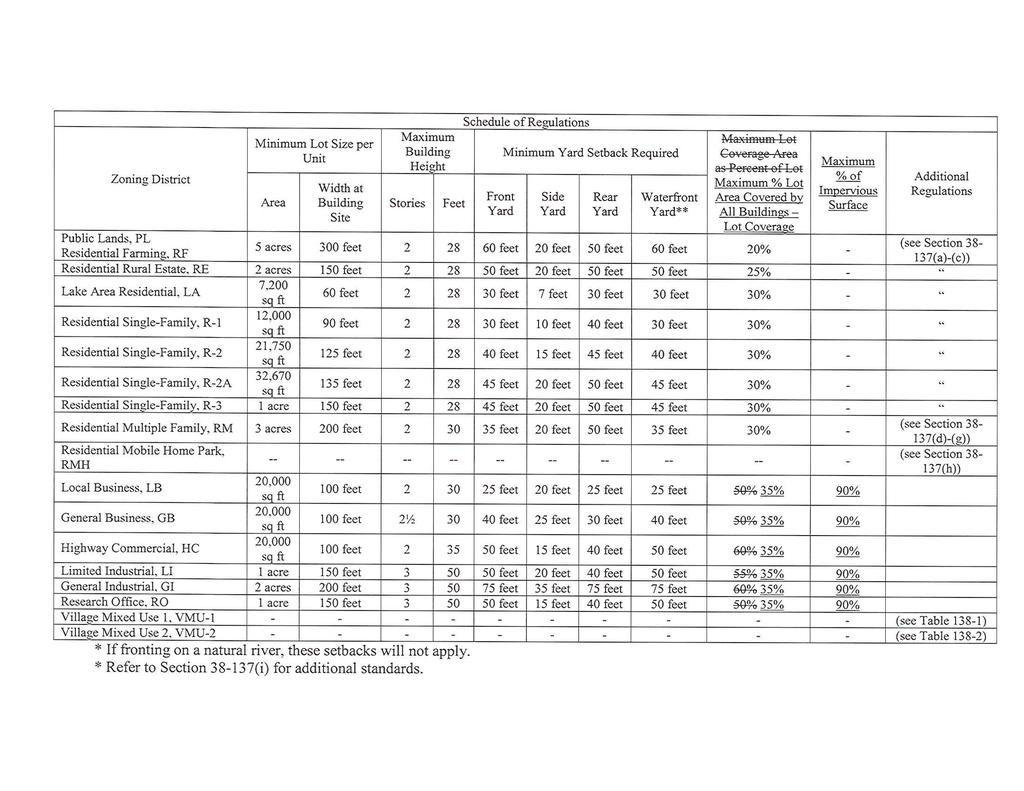
51
Exhibit 1 PLANNING COMMISSION AGENDA ITEM
 Exhibit 1 PLANNING COMMISSION AGENDA ITEM Project Name: Grand Junction Circulation Plan Grand Junction Complete Streets Policy Applicant: City of Grand Junction Representative: David Thornton Address:
ACTIVE TRANSPORTATION
 ACTIVE TRANSPORTATION Mobility 2040 Supported Goals Improve the availability of transportation options for people and goods. Support travel efficiency measures and system enhancements targeted at congestion
Perryville TOD and Greenway Plan
 Perryville TOD and Greenway Plan Greenway Glossary Pathway: A bicycle and pedestrian path separated from motorized vehicular traffic by an open space, barrier or curb. Multi-use paths may be within the
Proposed. City of Grand Junction Complete Streets Policy. Exhibit 10
 Proposed City of Grand Junction Complete Streets Policy Exhibit 10 1 City of Grand Junction Complete Streets Policy Vision: The Complete Streets Vision is to develop a safe, efficient, and reliable travel
Living Streets Policy
 Living Streets Policy Introduction Living streets balance the needs of motorists, bicyclists, pedestrians and transit riders in ways that promote safety and convenience, enhance community identity, create
PEDESTRIAN ACTION PLAN
 ATTACHMENT 2 CITY OF SANTA MONICA PEDESTRIAN ACTION PLAN CITY OF SANTA MONICA PEDESTRIAN ACTION PLAN This page intentionally left blank EXECUTIVE SUMMARY CHAPTER 1 EXECUTIVE SUMMARY Setting the Stage
o n - m o t o r i z e d transportation is an overlooked element that can greatly enhance the overall quality of life for the community s residents.
 N o n - m o t o r i z e d transportation is an overlooked element that can greatly enhance the overall quality of life for the community s residents. 84 Transportation CHAPTER 11 INTRODUCTION Transportation
Physical Implications of Complete Streets Policies
 Presentation Overview Physical Implications of Complete Norm Cox, ASLA, LLA Landscape Architect Ann Arbor, Michigan, 10:45 to Noon What Are Complete Streets? What Matters to Bicyclists and Pedestrians
Corpus Christi Metropolitan Transportation Plan Fiscal Year Introduction:
 Introduction: The Safe, Accountable, Flexible, Efficient Transportation Equity Act: A Legacy for Users (SAFETEA-LU) has continued the efforts started through the Intermodal Surface Transportation Efficiency
4 Goals, Objectives & Actions
 Chapter4 4 This chapter presents goals, objectives, and recommended actions to support the vision of making Overland Park a safer and easier place to ride a bicycle. 35 4.1 Recommendations Structure The
Chapter 2: Standards for Access, Non-Motorized, and Transit
 Standards for Access, Non-Motorized, and Transit Chapter 2: Standards for Access, Non-Motorized, and Transit The Washtenaw County Access Management Plan was developed based on the analysis of existing
Clackamas County Comprehensive Plan
 ROADWAYS The County s road system permits the movement of goods and people between communities and regions, using any of a variety of modes of travel. Roads provide access to virtually all property. They
Madison Urban Area and Dane County. Bicycle Transportation Plan Summary. September Introduction. Bicycle Plan Scope and Planning Process
 Bicycle Transportation Plan Summary Madison Urban Area and Dane County Introduction September 2000 Bicycling is an important mode of transportation in the Madison urban area and countywide that is available
Non-Motorized Transportation 7-1
 Non-Motorized Transportation 7-1 Transportation facilities no longer mean just accommodating a vehicle powered by a combustion engine. Pedestrian and non-motorized facilities are important modes of travel
CONNECTING PEOPLE TO PLACES
 CONNECTING PEOPLE TO PLACES 82 EAST BENCH MASTER PLAN 07 Introduction The East Bench transportation system is a collection of slow moving, treelined residential streets and major arteries that are the
CITY OF BLOOMINGTON COMPLETE STREETS POLICY
 CITY OF BLOOMINGTON COMPLETE STREETS POLICY POLICY OBJECTIVE: The City of Bloomington will enhance safety, mobility, accessibility and convenience for transportation network users of all ages and abilities,
INTRODUCTION THOROUGHFARE SYSTEM CLASSIFICATIONS
 INTRODUCTION The thoroughfare plan will assist public officials in the development of a specialized system for efficient and safe movement of vehicular traffic while minimizing potential conflicts with
Goal 3: Foster an environment of partnerships and collaboration to connect our communities and regions to one another.
 Non-Motorized Transportation Plan (NMTP) Draft Vision, Goal and,, Tri-County Regional Planning Commission (TCRPC) Purpose The purpose of the Tri-County Regional Planning Commission (TCRPC) Non-Motorized
Chapter 5 Future Transportation
 Chapter 5 Future Transportation The Future Land Use Plan identifies the desired land use designations. The land uses desired for Crozet depend, in large part, on the success of the transportation system,
Chapter 5. Complete Streets and Walkable Communities.
 Chapter 5. Complete Streets and Walkable Communities. 5.1 Description of Complete Streets. Cities throughout the world, and specifically the United States, are coming to embrace a new transportation and
General Design Factors
 Chapter 3: 3-1.0 Introduction General Design Factors Mn/DOT s goals include encouraging and accommodating safe bicycling. From a design perspective, these goals are achieved by first having an understanding
INDOT Complete Streets Guideline & Policy
 INDOT Complete Streets Guideline & Policy INTRODUCTION The Complete Streets guidelines build upon multiple efforts and promote a multimodal transportation system that is integrated and sustains land use
City of Novi Non-Motorized Master Plan 2011 Executive Summary
 City of Novi Non-Motorized Master Plan 2011 Executive Summary Prepared by: February 28, 2011 Why Plan? Encouraging healthy, active lifestyles through pathway and sidewalk connectivity has been a focus
5 CIRCULATION AND STREET DESIGN
 5 CIRCULATION AND STREET DESIGN This chapter describes circulation and streetscape improvements proposed for the Northwest Chico Specific Plan Area. It includes detailed design specifications for existing
RESOLUTION NO ?? A RESOLUTION OF THE CITY OF NEPTUNE BEACH ADOPTING A COMPLETE STREETS POLICY
 RESOLUTION NO. 2018-?? A RESOLUTION OF THE CITY OF NEPTUNE BEACH ADOPTING A COMPLETE STREETS POLICY WHEREAS, safe, convenient, and accessible transportation for all users is a priority of the City of Neptune
Chapter 2. Bellingham Bicycle Master Plan Chapter 2: Policies and Actions
 Chapter 2 Bellingham Bicycle Master Plan Chapter 2: Policies and Actions Chapter 2: Policies and Actions The Bicycle Master Plan provides a road map for making bicycling in Bellingham a viable transportation
MAG Town of Cave Creek Bike Study Task 6 Executive Summary and Regional Significance Report
 Page 1 MAG Town of Cave Creek Bike Study Task 6 Executive Summary and Regional Significance Report August 1, 2012 MAG Project #481 Page 2 Task 6 Executive Summary and Regional Significance Report Introduction
Recommended Roadway Plan Section 2 - Land Development and Roadway Access
 Recommended Roadway Plan Section 2 - Land Development and Roadway Access SECTION 2 Land Development and Roadway Access 2.1 Land Use and Access Management The Federal Highway Administration (FHWA) defines
Circulation in Elk Grove includes: Motor vehicles, including cars and trucks
 Circulation, as it is used in this General Plan, refers to the many ways people and goods move from place to place in Elk Grove and the region. Circulation in Elk Grove includes: Motor vehicles, including
TOWN OF PORTLAND, CONNECTICUT COMPLETE STREETS POLICY
 TOWN OF PORTLAND, CONNECTICUT COMPLETE STREETS POLICY I. VISION, GOALS & PRINCIPLES VISION To improve the streets of Portland making them safer and more accessible for all users including pedestrians,
Street Paving and Sidewalk Policy
 City Commission Policy 600 Street Paving and Sidewalk Policy DEPARTMENT: Public Works DATE ADOPTED: June 7, 1995 DATE OF LAST REVISION: December 10, 2014 Policy No. 600.01 AUTHORITY: PASS City of Tallahassee-Leon
WHEREAS, the New Jersey Department of Transportation' s Complete Streets
 WHEREAS, the State Department of Transportation adopted a Complete Streets Policy ( Policy No. 703), effective December 3, 2009, for all projects funded through the Department' s Capital Program and strongly
Bicycle Master Plan Goals, Strategies, and Policies
 Bicycle Master Plan Goals, Strategies, and Policies Mobilizing 5 This chapter outlines the overarching goals, action statements, and action items Long Beach will take in order to achieve its vision of
Agenda. Overview PRINCE GEORGE S PLAZA METRO AREA PEDESTRIAN PLAN
 PRINCE GEORGE S PLAZA METRO AREA PEDESTRIAN PLAN May 28, 2008 Agenda Welcome and introductions Project overview and issue identification Planning context and strengths Design challenges and initial recommendations
Chapter 7. Transportation. Transportation Road Network Plan Transit Cyclists Pedestrians Multi-Use and Equestrian Trails
 Chapter 7 Transportation Transportation Road Network Plan Transit Cyclists Pedestrians Multi-Use and Equestrian Trails 7.1 TRANSPORTATION BACKGROUND The District of Maple Ridge faces a number of unique
NM-POLICY 1: Improve service levels, participation, and options for non-motorized transportation modes throughout the County.
 Transportation PRINCE WILLIAM COUNTY 2008 COMPREHENSIVE PLAN NON-MOTORIZED PLAN CONTENTS Goals, Policies, and Action Strategies Table 4 (Bike Facility Classifications and Descriptions) Table 5 (Bike Facility
Access Management Regulations and Standards
 Access Management Regulations and Standards Efficient highway operation Reasonable property access Concept of Access Management The way to manage access to land development while simultaneously preserving
Solana Beach Comprehensive Active Transportation Strategy (CATS)
") Solana Beach Comprehensive Active Transportation Strategy (CATS) 3.0 Goals & Policies The Solana Beach CATS goals and objectives outlined below were largely drawn from the Solana Beach Circulation Element
Solana Beach Comprehensive Active Transportation Strategy (CATS) 3.0 Goals & Policies The Solana Beach CATS goals and objectives outlined below were largely drawn from the Solana Beach Circulation Element
This page intentionally left blank.
 This page intentionally left blank. COMMUNITY Coweta Community Overview Coweta Coweta, a residential community located in Wagoner County, is a suburb of Tulsa situated southeast of the metropolitan area
REGIONAL BICYCLE AND PEDESTRIAN DESIGN GUIDELINES
 REGIONAL BICYCLE AND PEDESTRIAN DESIGN GUIDELINES November 16, 2011 Deb Humphreys North Central Texas Council of Governments Bicycle and Pedestrian Advisory Committee Snapshot of the Guide 1. Introduction
Roadway Classification Design Standards and Policies. Pueblo, Colorado November, 2004
 Roadway Classification Design Standards and Policies Pueblo, Colorado November, 2004 Table of Contents Page Chapter 1. General Provisions 1.1 Jurisdiction 3 1.2 Purpose and Intent 3 1.3 Modification 3
BIKE PLAN CONTENTS GATEWAY
 CONTENTS Acknowledgments...vii Great Rivers Greenway District Board of Directors... vii Great Rivers Greenway District Staff... vii Project Consultants... vii Committees... viii Citizens Advisory Committee
ARLINGTON COUNTY, VIRGINIA
 ARLINGTON COUNTY, VIRGINIA County Board Agenda Item Meeting of October 15, 2016 DATE: October 7, 2016 SUBJECT: Adoption of amendments to the Master Transportation Plan (MTP) to create a new Pedestrian
City of Saline. Complete Streets Ordinance
 City of Saline Complete Streets Ordinance September 13 and 20, 2010 CARLISLE/WORTMAN ASSOCIATES What Are Complete Streets? Complete streets are designed to serve everyonemotorists as well as pedestrians
Michael Parmer, Management Aide, City Manager's Office
 P139 STAFF REPORT f CITY NL- NAGER' S OFFICE RANCHO Date: C;UCAMONGA To: From: Subject: Mayor and Members of the City Council John R. Gillison, City Manager Michael Parmer, Management Aide, City Manager's
APPROVE A RESOLUTION ADOPTING A COMPLETE STREETS POLICY
 STAFF REPORT MEETING DATE: September 13, 2016 TO: FROM: City Council Bob Brown, Community Development Director Russ Thompson, Public Works Director Patrick Filipelli, Management Analyst 922 Machin Avenue
August 3, Bay Trail Connection With The Community
 Ms. Lina Velasco, Senior Planner City of Richmond Planning Division P.O. Box 4046 Richmond, CA 94804 Dear Ms. Velasco: August 3, 2009 73 Belvedere Ave. Richmond, CA 94801 Phone/Fax: 510-235-2835 Email:tracbaytrail@earthlink.net
APPENDIX A: Complete Streets Checklist DRAFT NOVEMBER 2016
 APPENDIX A: Complete Streets Checklist DRAFT NOVEMBER 2016 Complete Streets Checklist MetroPlan Orlando s Complete Streets Checklist is an internal planning tool for staff to further implementation of
Bikeway action plan. Bicycle Friendly Community Workshop March 5, 2007 Rochester, MN
 Bikeway action plan Summary The was held on March 5, 2007 at the Rochester Mayo Civic Center. The workshop was hosted by Rochester-Olmsted County Planning Department in collaboration with the League of
Basalt Creek Transportation Refinement Plan Recommendations
 Basalt Creek Transportation Refinement Plan Recommendations Introduction The Basalt Creek transportation planning effort analyzed future transportation conditions and evaluated alternative strategies for
Double the amount of bicycle ridership while at the same time reducing the number of bicycle crashes by one-third.
 CHAPTER 6 Recommended Policies and Action Items To achieve the goals stated in Chapter 1 and guide implementation of the Bicycle Plan, policies and action items have been identified. They are presented
Access Management Regulations and Standards for Minor Arterials, Collectors, Local Streets
 Access Management Regulations and Standards for Minor Arterials, Collectors, Local Streets September 2009 Paul Grasewicz Access Management Administrator Concept of Access Management The way to manage access
CITY OF ELKO BICYCLE AND PATHWAY PLAN
 CITY OF ELKO BICYCLE AND PATHWAY PLAN INTRODUCTION: The City of Elko is intended to provide the basic framework for the development of a functional bicycle and pathway system for the community with connections
Active Transportation Facility Glossary
 Active Transportation Facility Glossary This document defines different active transportation facilities and suggests appropriate corridor types. Click on a facility type to jump to its definition. Bike
Complete Streets for Louisiana
 Complete Streets for Louisiana Louisiana Transportation Conference 2011 Ellen W. Soll, AICP Planner Burk-Kleinpeter, Inc esoll@bkiusa.com 504.486.5901 x143 What is a Complete Street? What are Complete
Omaha s Complete Streets Policy
 Omaha s Complete Streets Policy (Adopted August 2015) VISION To create great places and enhance our quality of life, the City of Omaha will provide safe, accessible streets for all users. Complete Streets
Executive Summary Route 30 Corridor Master Plan
 Route Corridor Master Plan Project Overview The Route Corridor Master Plan is a coordinated multimodal transportation and land use plan for the entire stretch of Route through East Whiteland Township,
Vision: Traditional hamlet with an attractive business/pedestrian friendly main street connected to adjacent walkable neighborhoods
 N D. Focus Area II Vision: Traditional hamlet with an attractive business/pedestrian friendly main street connected to adjacent walkable neighborhoods Transit Road Focus Area II is located in the Hamlet
WELCOME TO OPEN HOUSE # 1 June 14, 2017
 Langstaff Road Weston Road to Highway 7 Class Environmental Assessment Study WELCOME TO OPEN HOUSE # 1 June 14, 2017 Please sign in and join our mailing list Purpose of Open House #1 & Study Area York
REMOVE BARRIERS TO, ENCOURAGE CREATION OF AND PROVIDE GUIDELINES FOR SAFE ROUTES (ALL DISTRICTS)
") Ordinance 2009-98 AN ORDINANCE OF THE BOARD OF SUPERVISORS OF PIMA COUNTY, ARIZONA; RELATING TO ZONING; AMENDING THE PIMA COUNTY ZONING CODE TITLE 18 BY AMENDING SECTION 18.03.020 (DEFINITIONS) TO ADD
Ordinance 2009-98 AN ORDINANCE OF THE BOARD OF SUPERVISORS OF PIMA COUNTY, ARIZONA; RELATING TO ZONING; AMENDING THE PIMA COUNTY ZONING CODE TITLE 18 BY AMENDING SECTION 18.03.020 (DEFINITIONS) TO ADD
West Dimond Blvd Upgrade Jodhpur Street to Sand Lake Road
 West Dimond Blvd Jodhpur St to Sand Lake CSS Transportation Project Summary Municipality of Anchorage Project # 05 005 Project Manager: John Smith, P.E. (MOA PM&E) Project Administrator: Julie Makela,
Report. Typical Sections. City of Middleton, WI
 Report Typical Sections City of Middleton, WI December 2006 Report for City of Middleton, Wisconsin Typical Sections repared by: Traffic Associates LLC and STRAND ASSOCIATES, INC. 910 West Wingra Drive
Bicycle and Pedestrian Advisory Committee (BPAC) November 21, 2013
 November 21, 2013") Bicycle and Pedestrian Advisory Committee (BPAC) November 21, 2013 OVERALL LAND USE CONCEPT Overall Broadway Valdez District: 95.5 acres (35.1 acres right-of ways + 60.4 acres developable land) Plan Subareas:
Bicycle and Pedestrian Advisory Committee (BPAC) November 21, 2013 OVERALL LAND USE CONCEPT Overall Broadway Valdez District: 95.5 acres (35.1 acres right-of ways + 60.4 acres developable land) Plan Subareas:
Multimodal Through Corridors and Placemaking Corridors
 68 Multimodal Through Corridors and Placemaking Corridors Corridors have different functions in a region. Some corridors are used to get smoothly and rapidly through a region or to get quickly to major
AMATS Complete Streets Policy
 AMATS Complete Streets Policy Table of Contents: Section 1. Definition of Complete Streets Section 2. Principles of Complete Streets Section 3. Complete Streets Policy Section 4. Consistency Section 5.
Land Use Patterns. Traditional Modern
 Street Types Pre WWII: tight street grid, straight connected streets, sidewalks and alleys, block size 400 or < Post WWII: curvilinear streets, cul-de-sacs, few sidewalks, large blocks at 600 or > and
NEIGHBORHOOD TRAFFIC CALMING POLICY
 NEIGHBORHOOD TRAFFIC CALMING POLICY I. PURPOSE The City of Kent continually strives to strengthen and protect its neighborhoods by improving the quality of life in residential areas. Traffic conditions
Lee s Summit Road Improvement Study Public Open House June 7, 2007 Summary of Comment Card Responses
 Lee s Summit Road Improvement Study Public Open House June 7, 2007 Summary of Comment Card Responses Introduction At the Lee s Summit Road Improvement Study Public Open House held Thursday, June 7, 2007
East Burke Transportation, Safety and Capacity Improvements
 East Burke Transportation, Safety and Capacity Improvements The purpose of this project is to increase mobility and improve safety for pedestrians, cyclists, and motor vehicles along VT Route 114 in the
CITY OF SEATTLE RESOLUTION. WHEREAS, the Washington State Department of Transportation (WSDOT) led the Seattle
 led the Seattle") SDOT SR0 Design Refinements RES August, 0 Version #D 0 CITY OF SEATTLE RESOLUTION..title A RESOLUTION relating to the State Route 0, Interstate to Medina Bridge Replacement and High Occupancy Vehicle Project;
SDOT SR0 Design Refinements RES August, 0 Version #D 0 CITY OF SEATTLE RESOLUTION..title A RESOLUTION relating to the State Route 0, Interstate to Medina Bridge Replacement and High Occupancy Vehicle Project;
CITY OF COCOA BEACH 2025 COMPREHENSIVE PLAN. Section VIII Mobility Element Goals, Objectives, and Policies
 CITY OF COCOA BEACH 2025 COMPREHENSIVE PLAN Section VIII Mobility Element Goals, Objectives, and Policies Adopted August 6, 2015 by Ordinance No. 1591 VIII MOBILITY ELEMENT Table of Contents Page Number
CHAPTER 1 INTRODUCTION
 CHAPTER 1 INTRODUCTION Chapter Table of Contents THE 2017 HOUSTON BIKE PLAN 1-1 HOUSTON BIKEWAYS PROGRAM 1-2 HISTORY OF BICYCLE PLANNING IN HOUSTON 1-3 BICYCLE LEVEL OF COMFORT 1-3 EXISTING PLANS, PROGRAMS
Cross Street Corridor Non-Motorized Enhancement Project Project Description
 Cross Street Corridor Non-Motorized Enhancement Project Project Description A cooperative study of the Cross Street neighborhood was completed in May 2002 by the City of Ypsilanti, the Depot Town Downtown
Final Sidewalk Feasibility Study
 Garfield Drive From Anastasia Drive to Elizabeth Place City of South Daytona July 23, 2009 Final Sidewalk Feasibility Study Prepared for: Prepared by: Final Sidewalk Feasibility Study Garfield Drive 2
TRAVEL PLAN: CENTRAL EUROPEAN UNIVERSITY CAMPUS REDEVELOPMENT PROJECT TRAVEL PLAN. Central European University Campus Redevelopment Project.
 TRAVEL PLAN Central European University Campus Redevelopment Project Page 1 Table of Contents Introduction... 3 Background... 7 Building Users... 7 Transportation in Community Consultation... 7 Summary
City Council Agenda Item #6-A CITY OF ALAMEDA Memorandum. To: Honorable Mayor and Members of the City Council. John A. Russo City Manager
 CITY OF ALAMEDA Memorandum To: From: Honorable Mayor and Members of the City Council John A. Russo City Manager Date: January 14, 2013 Re: Adopt a Resolution Approving a Complete Streets Policy, in Accordance
COUNCIL POLICY NAME: COUNCIL REFERENCE: 06/119 06/377 09/1C 10llC 12/1C INDEX REFERENCE: POLICY BACKGROUND
 COUNCIL POLICY NAME: COUNCIL ADVISORY COMMITTEES - TERMS OF REFERENCE ISSUED: APRIL 3, 2006 AMENDED: NOVEMBER 27, 2006 NOVEMBER 23, 2009 JANUARY 11, 2010 DECEMBER 17, 2012 POLICY COUNCIL REFERENCE: 06/119
SECTION 1 - TRAFFIC PLANNING
 SECTION 1 - TRAFFIC PLANNING 1.1 TRAFFIC OPERATIONS 1.1.1 Roadway Functional Classification The Multnomah County Comprehensive Framework Plan s Policy 34: Trafficways and the Functional Classification
Kalamazoo Area Transportation Study (KATS) Complete Streets Policy Approved: Effective: FY 2018 Projects
 Complete Streets Policy Approved: Effective: FY 2018 Projects") Kalamazoo Area Transportation Study (KATS) Complete Streets Policy Approved: Effective: FY 2018 Projects 1.0 Defined 2.0 Introduction/Justification 3.0 Vision & Intent 4.0 Applicability 5.0 Design 6.0
Kalamazoo Area Transportation Study (KATS) Complete Streets Policy Approved: Effective: FY 2018 Projects 1.0 Defined 2.0 Introduction/Justification 3.0 Vision & Intent 4.0 Applicability 5.0 Design 6.0
Broad Street Bicycle Boulevard Design Guidelines
 Broad Street Bicycle Boulevard Design Guidelines Building from the strategies introduced in the 2013 Bicycle Transportation Plan and community input received thus far, City Transportation Staff have identified
DRAFT. Table of Contents. Background
 Douglas County Table of Contents Existing Infrastructure 86 Funding 89 Policy and Program Recommendations 90 Infrastructure Recommendations 92 Conclusion 95 Background Home to 4,500 residents and Baker
Evolving Roadway Design Policies for Walking and Bicycling
 Evolving Roadway Design Policies for Walking and Bicycling The 2016 Michigan Transportation Planning Conference Kalamazoo, MI July 13, 2016 Title 23 of the Code of Federal Regulations Title 23 was originally
Bicycle and Pedestrian Chapter TPP Update Overview. TAB September 20, 2017
 Bicycle and Pedestrian Chapter TPP Update Overview TAB September 20, 2017 Bicycling & Walking in the Twin Cities Where are we now? The Bike-Pedestrian system Current trends New developments Where are we
5. RUNNINGWAY GUIDELINES
 5. RUNNINGWAY GUIDELINES These guidelines should be considered collectively when making runningway decisions. A runningway is the linear component of the transit system that forms the right-of-way reserved
Washington County, Oregon
 Washington County, Oregon Photo add here 1 Washington County, Oregon Total population: 536,370 City population: 320,000 Based on 2010 Census Rural population: 26,000 Urban Unincorporated Population: 190,000
Hennepin County Bicycle and Pedestrian Planning
 Hennepin County Bicycle and Pedestrian Planning 1 Value of bicycle and sidewalk systems Safety Livability Mobility Health Personal Finances Economic Sustainability Clean Air Recreation Parking and congestion
CITY MANUALS AND STANDARDS REVIEW
 GEORGETOWN SIDEWALK MASTER PLAN CITY MANUALS AND STANDARDS REVIEW RESOURCES AND STANDARDS As part of the Master Plan process, a review and evaluation of current City documents and policies relevant to
Chapter 5 FUNCTIONAL CLASSIFICATION
 Chapter 5 FUNCTIONAL CLASSIFICATION Functional classification is a system by which streets and roadways may be distinguished by types according to their function within the entire transportation network.
7/23/2017 VIA . Michael Hanebutt City of Sacramento Community Development Department 300 Richards Boulevard, 3 rd Floor Sacramento, CA 95811
 7/23/2017 VIA EMAIL Michael Hanebutt City of Sacramento Community Development Department 300 Richards Boulevard, 3 rd Floor Sacramento, CA 95811 RE: 65 th Street Apartments (DR17-220) Dear Mr. Hanebutt:
Complete Streets. Designing Streets for Everyone. Sarnia
 Complete Streets Designing Streets for Everyone Sarnia Complete Streets ~ Sarnia ~ 2018 Introduction Our City is made up of a network of streets that we use to go for a walk, cycle to work, drive to the
Bicycle Boulevards and Neighborhood Greenways
 Bicycle Boulevards and Neighborhood Greenways Traffic Safety is Improving for Everyone 90 80 70 60 50 40 30 20 10 0 PORTLAND: TOTAL TRAFFIC FATALITIES 1986-2008 1986 1987 1988 1989 1990 1991 1992 1993
ACTIVE TRANSPORTATION/NONMOTORIZED TRANSPORTATION
 ACTIVE TRANSPORTATION/NONMOTORIZED TRANSPORTATION BACKGROUND Active transportation, also known as nonmotorized transportation, is increasingly recognized as an important consideration when planning and
PennDOT Access Management Model Ordinances Training
 PennDOT Access s Training Trainers: Chad Dixson, AICP, TPD Angela Watson, PB Objective of Today Assist Pennsylvania s municipalities and transportation professionals in better understanding the benefits
This page intentionally left blank.
 This page intentionally left blank. COMMUNITY Glenpool Community Overview Glenpool Glenpool is a city of nearly 12,000 residents located in Tulsa County southwest of Tulsa and Jenks. The city is growing
AGENDA ITEM NO. 5b HCAOG TAC meeting of May 8, 2014
 Humboldt County Association of Governments Eureka, CA, 95501 AGENDA ITEM NO. 5b HCAOG TAC meeting of May 8, 2014 DATE: May 1, 2014 TO: HCAOG Technical Advisory Committee (TAC) FROM:, SUBJECT: Letters of
/ ARLINGTON COUNTY, VIRGINIA
 / ARLINGTON COUNTY, VIRGINIA County Board Agenda Item Meeting of September 24, 2016 DATE: August 11, 2016 SUBJECT: Amendment of the Master Transportation Plan (MTP) Streets Element to include new local
Classification Criteria
 SCHEDULE D TO RECOMMENDED OFFICIAL PLAN AMENDMENT NO. 40 SCHEDULE C-4 Road Criteria Criteria Traffic Service Objective Land Service/Access Typical Daily Traffic Volume Flow characteristics Travel Speed
Exhibit B: Proposed amendments to the Transportation Element of the Oakland Comprehensive Plan
 Exhibit B: Proposed amendments to the Transportation Element of the Oakland Comprehensive Plan TRANSPORTATION Introduction An important aspect of any community is its transportation system, the means by
Safe Routes to School Action Plan Aberdeen, Idaho
 Background Aberdeen, Idaho is a largely agricultural community of nearly 2,000 people and is located in the southeast portion of the state on the western edge of American Falls Reservoir. The community
Develop a Multi-Modal Transportation Strategy (Theme 6)
") DEVELOP A MULTI-MODAL TRANSPORTATION STRATEGY (THEME 6) WHY IS THIS THEME ADDRESSED? Develop a Multi-Modal Transportation Strategy (Theme 6) Statement of Ideal Reduce resident and visitor reliance on single
DEVELOP A MULTI-MODAL TRANSPORTATION STRATEGY (THEME 6) WHY IS THIS THEME ADDRESSED? Develop a Multi-Modal Transportation Strategy (Theme 6) Statement of Ideal Reduce resident and visitor reliance on single