Bicycle & Pedestrian Section DRAFT: October 29, 2015
|
|
|
- April Morris
- 5 years ago
- Views:
Transcription

1 Janesville Area Long Range Transportation Plan Executive Summary Bicycle & Pedestrian Section DRAFT: October 29, 2015 Photo by Den Adler
2 INTRODUCTION AND PURPOSE The Janesville Area MPO Bicycle and Pedestrian Plan serves as a long-range action plan for development and construction of on-street and off-street bicycle and pedestrian facilities within the urban area. The plan proposes extensions to the linear trail system already established along the Rock River and throughout several greenbelt areas within the MPO planning boundary, and it initiates a recognizable on-street system designed to promote bicycle use and safety for cyclist traveling on arterial streets. This plan provides an overview of existing and funded street and mixed-use trail projects, outlines goals and objectives for enhancing multimodal travel and recreation within the urban area, and identifies an improvement program for implementation between The bicycle and pedestrian plan has been developed for the Janesville area for several reasons. The plan responds to the increased public interest in trails, walkways, and on-street bike facilities for both recreation and transportation access by defining corridors where bicycles and pedestrian accommodations would most benefit the community. The plan also documents the strengths and weaknesses of the current system and the policies which guide active transportation planning in the urban area. Finally, the plan addresses the goals of the Moving Ahead for Progress in the 21 st Century (MAP-21) which places great emphasis on non-traditional modes of transportation and requires that States and MPO s develop transportation plans that include bicycle and pedestrian projects and programs. GOALS AND OBJECTIVES Janesville s existing bicycle and pedestrian system provides a strong foundation for improving mobility and offering an enjoyable form of recreation. This plan seeks to encourage and provide for continued growth in the number of trips taken by bicyclists and pedestrians for all transportation purposes while also maintaining proper safety standards. Both off-road trails and shared roadway bicycle/pedestrian facilities are important to a balanced transportation network that serves the needs of all potential user groups. The following goals and objectives reflect what the MPO expects to accomplish over the next twenty years in regards to developing an effective, efficient bicycle and pedestrian network. GOAL: Develop a multi-modal transportation network within the Janesville Metropolitan Planning area that accommodates all modes of transportation and recreation and provides for the safe, efficient movement of people and goods. OBJECTIVES: Develop an on-street and off-street bicycle facility network that serves as a viable transportation option for beginning to advanced cyclists. Provide bicycle and pedestrian facilities between residential areas and existing and planned employment and commercial centers, school facilities, parks and recreational facilities, and other public facilities.
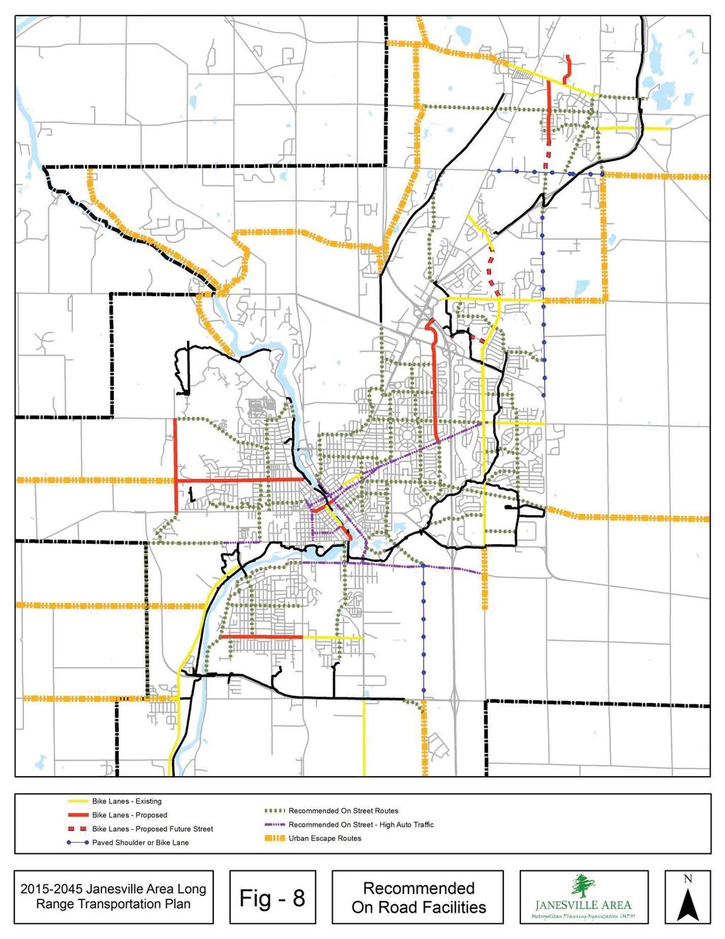
3 Encourage and facilitate the provision of appropriate end of trip facilities such as bike racks, lockers, and showers at employment and commercial centers. Provide cyclists with safe and convenient travel by making streets bicycle friendly and well designed to accommodate both motorized and non-motorized modes of transportation. Coordinate planning, programming, events, and advocacy with organizations that have similar goals. Gain input from bicyclists and the public in the planning and development of bicycle and pedestrian facilities. Develop education and safety programs aimed at children (for walking and biking), experienced bicyclists, and motor vehicle operators. Encourage active enforcement of existing laws for motor vehicle operators regarding the rights of bicyclists and pedestrians. FACILITY DEVELOPMENT PROCESS Input from the public plays a crucial role in identifying transportation issues and prioritizing improvements. The objectives of this plan help to define where bicycle and pedestrian facilities will be developed and what type of bicycle and pedestrian facilities will be constructed. Connections between parks, specialized recreation facilities, and public centers are very important to the Janesville Area MPO. Convenient access, safety, varying levels of bicycling experience, and of course financial resources, will affect the decision as to what type of facilities will be constructed within the Janesville Area MPO planning area. In regards to bicycle facilities, bike paths are often preferred means of travel for less-experienced or younger bicyclists. The Bicycle/Pedestrian Sub-committee took into account the level of comfort a less experienced bicyclist would have when considering recommendations. Planning criteria determine the best kind of facilities to develop for both pedestrian and bicyclists. PROPOSED BICYCLE AND PEDESTRIAN FACILITIES Street Projects City of Janesville Proposed Bicycle Lanes Court Street Academy Street to Main Street Austin Road Court Street to Memorial Avenue Mineral Point Road Parker High School to Franklin Street and the Ice Age Trail Kellogg Avenue South River Road to Center Avenue Pontiac Drive E. Milwaukee Street to Ryan Road
4 Read Road: Delavan Drive to STH 11 (La Prairie Township) Since this is a town road cross section the improvement recommended is for paved shoulders. This improvement would provide a link between the bypass trail and the Ice Age Trail via Sharon Road. N. Harmony Townhall Road: USH 14 to STH 26 (Harmony Township) The Streets & Highways Chapter makes a long range recommendation to reconstruct this roadway into a four lane urban cross section. Reconstruction would take place in conjunction with jurisdictional transfer to the City of Janesville and the type of bicycle accommodation would be determined at that time. This is currently a town road cross section and the addition of paved shoulders would be an appropriate short-term accommodation. Townline Road: CTH Y to Henke Road Since this is a town road cross section the improvement recommended is for paved shoulders. Hilltop Drive & Northside Drive: Townline Road to Northside Drive Terminus (City of Milton) A north-south and east-west spine through the City of Milton was identified as a potential location for bicycle lanes in the City of Milton Comprehensive Plan. This north-south spine would run through the center of the City and generally follow the alignments of North Side Drive and Hilltop Drive, from a planned extension of Sunset Drive on the north to Town Line Road on the South. Road Reconfigurations or Road Diets A road diet is the conversion of an undivided four-lane roadway into two driving lanes and a center two-way left turn lane. The resulting roadway, with one driving lane in each direction and a two-way left turn lane is commonly called a TWLTL (pronounced Twiddle ). The reduction of driving lanes allows part of the roadway to be reallocated for other uses such as bike lanes, pedestrian crossing islands, and/or parking. FHWA guidance indicates roads with 15,000 ADT or less and with peak hour traffic counts of less than 1,000 per hour per direction are good candidates for a road diet. Some of the potential benefits of a three lane TWLTL over a four lane undivided road are: Improving safety for bicyclists. Improving speed limit compliance and decreasing crash severity when crashes do occur. The two-way left turn lane reduces the number of mid-block and intersection conflict points thereby reducing rear-end and side swipe crashes. The two-way left turn lane can be used by vehicles traveling in either direction for deceleration and refuge while making a midblock left turn maneuver. The two-way left turn lane can be used as an acceleration lane for vehicles turning left to enter the street from mid-block driveways. The two-way left turn lane can allow for easier and safer emergency vehicle movement, particularly during peak hour periods.
5 Driveway density, transit routes, the number and design of intersections along the corridor, as well as operational characteristics are some considerations to be evaluated before deciding to implement a road diet. The following roadway segments were identified as candidates for consideration of a road diet due to high driveway density, ADT volume, and other factors. E. Milwaukee Street Garfield to Wright Road This segment of E. Milwaukee Street remains a four lane undivided roadway, while segments of the street on either side have previously been reconfigured. The segment between Milton and Garfield is west bound traffic only and was converted from two travel lanes to one travel lane and two bike lanes on either side. This conversion was implemented primarily to improve traffic operations. The segment between Wright Road and USH 14 was reconfigured in order to provide a center refuge island where the Ice Age Trail intersects with E. Milwaukee Street. For the segment between Garfield and Wright, 2013 ADT ranges from 10,300 to 12,400 along the corridor. Maximum total peak hour traffic is 1,100 per hour, but available data does not split the traffic counts by direction. Surrounding land uses are primarily single family residential and some neighborhood commercial. Marshall Middle School and Monroe Elementary School are in close proximity to the intersection of E. Milwaukee Street and Pontiac. E. Memorial Milton Avenue to Memorial Bridge This road segment should be evaluated for a road diet in order to improve safety and calm traffic speeds. The Memorial Bridge is largely avoided by bicyclists because it is not a comfortable crossing. Therefore, an evaluation of on-street parking may be a more appropriate addition rather than bike lanes. This roadway segment has ADT of roughly 10,500 and total peak hour traffic is less than 1,000. Surrounding land uses include single family residential and multi-family residential as well as some neighborhood commercial. W. Court Pearl to Austin This road segment should be evaluated for a road diet in order to improve safety and calm traffic speeds. This roadway segment has ADT ranges of 10,600 to 11,200 and maximum total peak hour traffic of roughly 1,300 per hour.
6
7 Off-Street Trail Projects Off-street sections of the proposed bicycle path system are designed to meet AASHTO guidelines and WisDOT recommendations. A 10-foot two-directional paved path with a 5-foot minimum separation from adjacent roadways is the intended design for most sections. Where feasible and where space allows, these off-street segments should include a two foot wide crushed gravel shoulder on at least one side to accommodate runners and walkers. These trail routes have been selected for their scenic and functional attributes to link the employment and residential centers. It is expected that the trails will be used primarily for recreational purposes; however they are also designed to serve commuters and school trips. Where feasible and when opportunities arise, the MPO, the Cities of Janesville and Milton, and the townships should utilize available funding, or seek additional funds to purchase easements or development rights for future off street trails identified in this plan. More detailed project descriptions are listed below for short range and long range projects grouped by major responsible jurisdiction. The projects identified in Phase I are focused on the completion of and connection to existing facilities that will finalize the core network of trails and connect to the major on-street bicycle corridors. The number in parentheses refers to the map identification number referenced in Figure 9. Phase I: Short-Range Trail Plan The first phase of the Bicycle & Pedestrian Plan consists of those projects that will be constructed within the next 10 years. The 10-year plan consists of off-street trail segments and on-street bike lanes designed to connect four priority areas within the city. MPO staff identified the following four areas as top priorities for extension of the existing bicycle and pedestrian network: 1. Downtown Janesville 2. Glacial River Trail 3. Northeast Regional Park 4. Westside Fisher Creek COMMITTED PROJECTS HWY 14 West Connection: Deerfield Drive to Milton Ave. (1) The Wisconsin Department of Transportation will make connections in the area of the USH 14/Humes Rd. and the STH 26/Milton Ave. interchanges as part of the I-39/90 reconstruction project. Either sidewalk or asphalt trail will make connections to existing networks.
8 RECOMMENDED PROJECTS City of Janesville Short-Range Projects Downtown Bicycle/Pedestrian Bridge (2) A bicycle/pedestrian bridge is recommended to provide connectivity in the downtown that will be lost through the removal of the parking deck that spans the Rock River. The bridge may be located between the Milwaukee and Court Street bridges or located south of Court Street. This project is also identified in the Rock Renaissance Area Redevelopment & Implementation Strategy (ARISE). Downtown Riverwalk Town Square (3) This project establishes new riverwalk as well as modifies existing riverwalk along the east and west sides of the Rock River in the core of downtown. It also establishes riverwalk between Milwaukee Street and Court Street at the time of Parking Plaza removal where no trail currently exists on the east side and on the west side of the river the Ice Age Trail is delineated on the Parking Plaza with paint. The project elements include cantilevered walk on both sides of the river from roughly Milwaukee Street Bridge to Dodge Street, then on land walk from Dodge Street to Court Street. This project is included in downtown plans, including the Rock Renaissance Area Redevelopment and Implementation Strategy (ARISE). Traxler Park Trail Extension (4) An extension of the existing riverwalk on the east side of the Rock River will connect the downtown to Traxler Park. The project includes an at-grade crossing at Centerway and Main Street, and a potential boardwalk or tunnel crossing under the railroad trestle. This project is included in downtown plans, including the Rock Renaissance Redevelopment and Implementation Strategy (ARISE). A 2014 feasibility study explored several options for this improvement. Ice Age Trail West Side Downtown (5) There are two small segments of missing Ice Age Trail in the downtown on the west side of the Rock River between Court Street and the pedestrian bridge near the Jackson Street Bridge. These connections will likely be made incrementally as redevelopment of riverfront property occurs. Valley Park Connector (6) This approximately ¼ mile off street trail connection from Valley Park south to the 11 Bypass trail will provide connection between UW Rock County and the City s trail system. Westside Fisher Creek Trail (7) A 2.7 mile 10- foot wide trail extending from the parking lot in Rockport Park along a crosscountry ski trail, and the Fisher Creek corridor and under the railroad bridge to Rockport Road. It would then continue north along the Fisher Creek corridor under Rockport Road to West Court Street and then continue north to Mineral Point Avenue. The trail includes a connection to Parker High School.
9 Westside Greenbelt Trail (8) This trail would extend from the terminus of the Westside Fisher Creek Trail (project 7) near Parker High School north to Memorial Drive/CTH A and the Cook Arboretum utilizing land dedicated for greenbelt stormwater conveyance. Glacial River Trail HWY 26 Overpass to Glacial River Trail (9) The HWY 26 Bypass project, completed in 2014 by the State of Wisconsin, extended the Glacial River Trail south from Fort Atkinson to Janesville when the neighboring jurisdictions agreed to maintain the trail. The Glacial River Trail was not connected to the HWY 26 Overpass at the time of the bypass project due to physical constraints and existing development, although a signed on-street route provides direction to bicyclists. There are multiple possible alignments but the chosen alignment will be based on new development and redevelopment opportunities, as well as jurisdictional coordination efforts between the City of Janesville, Town of Harmony, and Rock County. The project is depicted as a large circle on the map. Spring Brook Trail - NE Regional Park Extension (10) An extension of the Spring Brook Trail north from its current terminus at Sandhill Drive within a planned greenbelt area through Northeast Regional Park to Rotamer Road. PHASE II: LONG-RANGE TRAIL PROJECT Long-range trail projects are those that will take a somewhat longer period of time to design and to locate funding sources. Depending on funding opportunities, some of these projects may be upgraded to short range projects or may not occur if no funding source is identified. City of Janesville Long-Range Projects Eastside Riverwalk Court Street to Racine (11) This segment is an extension of the downtown riverwalk along the east side of the Rock River from Court Street to E. Racine. This segment is expected to be constructed as redevelopment and revitalization of the downtown occurs. This project is included in downtown plans, including the Rock Renaissance Redevelopment and Implementation Strategy (ARISE). Sports Complex Loop Wuthering Hills to USH 14 Underpass (12) An extension of the Sports Complex Loop branching off at Wuthering Hills Drive and following the public greenbelt east to USH 14. An existing bridge at HWY 14 would provide a grade separated crossing for a future trail extension to the east of USH 14.
10 Spring Brook Trail NE to Harmony Town Hall (13) An extension of the Spring Brook Trail where it branches from the main trail near Brunswick Lane and travels northeast along the greenbelt and terminates at USH 14 north of E. Milwaukee Street. An underpass at HWY 14 is planned for construction at the time of USH 14 improvement. Spring Brook Trail - Rotamer Rd. to Highway 26 (14) This trail is a continuation of the Spring Brook Trail from the terminus of project 10 that ended at Rotamer Road. The trail will intersect with the future Wright Road and use the overpass as a crossing, and then intersect with the Glacial River Trail on the north side of HWY 26. The Wright Road overpass was constructed as part of the HWY 26 bypass and the road has sidewalk and bike lanes. City of Milton Projects Glacial River Trail Connector to Henke Road (15) An approximately ¼ mile connection from the Glacial River Trail to Henke Road will provide a more direct connection to Milton. Highway 26/59 Recreation Area (16) Recreational, multi-use trails will be included in the stormwater management and land use planning for the area as it develops. Bowers Lake Sunset Drive Trail (17) Beginning on the East side of Milton near the Storrs Lake Wildlife Area the trail would head westward into the City roughly along Bowers Lake Road. The trail would then wind through the Park Place Estates neighborhood, crossing Highway 26 at Nelson Road and the planned extension of Sunset Road, eventually connecting to John Paul Road and the proposed Clear Lake Trail. Janesville-Milton Ice Age Trail (18) Utilizing the abandoned Railroad right-of-way, extend the existing Ice Age Trail Connector from W. High Street, through Merchant Row to Serns Road. The proposed trail would be a 10 foot wide unpaved multi-use trail. Mud Lake Trail (19) A multi-purpose trail connecting the Mud Lake recreational area and residential neighborhoods north of the current developed area of the City. Undetermined Sponsor STH 11 Trail Extension (20) The reconstruction of the Avalon Road interchange will provide right-of-way for future trail from the current terminus of the trail at Read Road through the Diverging Diamond Interchange.
11 Rock County Projects Peace Trail To Beloit This trail will link the existing Peace Trail in the Village of Afton to the City of Beloit following the Rock River and Afton Road/County Highway D. The trail will primarily follow abandoned railroad right-of-way and connect with the City of Beloit and the SLATS area trail systems. This trail project is outside of the Janesville Area MPA and is listed here to demonstrate support and consistency with Rock County Plans.

12
13 Project # Project Name Timeframe Estimated Cost 2015$ Committed 1 Deerfield Dr. to Milton Ave. connection see note 1 Short Range Projects 2 Downtown Bicycle/Pedestrian Bridge $ 1,200,000 3 Downtown Riverwalk Town Square $ 1,506,822 4 Traxler Park Extension to Centerway $ 356,868 5 Ice Age Trail: Court to trail hub (Rockport Rd.) $ 231,840 6 Valley Park Connector $ 154,560 7 Westside Trail - Fisher Creek to Mineral Point $ 2,015,000 8 Westside Trail - Mineral Point to Arboretum $ 1,081,000 9 Glacial River Trail connection from HWY 26 overpass see note 2 10 NE Regional Park Extension to Rotamer Rd $444,360 Long Range Projects 11 Eastside Riverwalk: Court to Racine $1,407, Wuthering Hills Connection HWY 14 underpass $241, Springbrook Trail - NE to Harmony Town Hall $811, Rotamer Rd. to HWY $502, Glacial River Trail connection to Henke Road $125, HWY 26/59 recreation area $869, Bowers Lake/Sunset Trail $1,159, Janesville to Milton Trail $724, Mud Lake Trail $579,600 Notes 1 Funding for project included in committed I-39/90 reconstruction project Various alignments have been considered but none chosen. Depending upon final 2 chosen alignment, a trail utilizing the greenbelt north of John Paul Rd. varies from $965,000 to $1,060,000. An alignment on the south side of HWY 26 with ROW estimate $497,000
14 HAZARDOUS INTERSECTION AND AREAS Dangerous intersections and corridors may be areas with a large number of crashes, or areas that users perceive to be dangerous. Factors such as speed, traffic volume, and visibility, topographic features such as hills or sharp curves contribute to risk of a crash involving a motorized vehicle. Stakeholder Identified Hazards Centerway Avenue & Ice Age Trail Crossing Centerway is a four-lane undivided highway with high traffic volumes. The road also curves, which limits the sight distance for the person crossing the street. Wright Road & Ice Age Trail Crossing Wright Road has two driving lanes, two bike lanes, and two parking lanes in this location. There is signage and a painted crosswalk where the trail crosses. There is concern that if one car does stop for a person in the crosswalk, the vehicle behind the stopped car could maneuver around the stopped car and crash into the person crossing. Afton Road & Peace Trail Crossing Speed along Afton Road is likely a factor in users concern with this crossing. Young families visiting Rockport Park also use this crossing and may be concerned with speed. There are no sight distance concerns. John Paul Road STH 26 Bicycle/Pedestrian Overpass to Wright Road This section of John Paul Road is the signed on-street connection between Janesville s trail system and the Glacial River Trail. John Paul Road is a rural road with narrow shoulders and varying traffic speeds. Many attendees at public meetings voiced concern about this roadway. This roadway does not feel safe or comfortable to ride on. The segment of concern is highlighted on Figure 11 as a dashed red line. Madison Avenue & John Paul Road This intersection is a concern due to the volume of motorized traffic. The intersection is controlled by stop signs on John Paul Road. This intersection is also a high crash location, with two crashes occurring between 2005 and 2013, one fatal crash in 2011 involving a pedestrian and another injury crash involving a bicycle. High Street & John Paul Road This intersection is a concern due to the volume of motorized traffic and the proximity of Milton High School and Schilberg Park. The intersection is controlled by stop signs on High Street. Madison Avenue & N. Clear Lake Avenue (Hwy 59) This intersection is a concern due to volume of traffic. Temporary stop signs are used during school crossing guard hours.
.")
15 Northside Drive & E. Madison Avenue (Hwy 59) This intersection is a concern due to volume of traffic. Temporary stop signs are used during school crossing guard hours. High Crash Locations The MPO analyzed crash data using MV4000, a web-based search tool developed and maintained by the Wisconsin Traffic Operations and Safety Laboratory (TOPS). The MPO searched for crashes between motorized vehicles and bicyclists and pedestrians. The MPO analyzed crash data Center Avenue & Rockport Road 8 crashes Racine & Main 6 crashes Racine Avenue & Randall Road 6 crashes Centerway & Main Street 5 crashes Design and Safety Improvements In order to address dangerous intersections and other locations identified above a further analysis of the contributing factors must be examined. There are many examples of what can be done to improve bicycle and pedestrian safety at high risk locations throughout the MPO. MPO communities have implemented various treatments in order to improve safety for all users, including road diets, signage, and pedestrian crossing islands. No specific recommendations to address these hazards are contained in this plan because communities must evaluate available data and seek public input in order to develop a context sensitive solution. Safety improvement at E. Milwaukee Street and Ice Age Trail Crossing. Photo by MPO staff

16
17 Other Facilities and Amenities Customer feedback from trail surveys indicate trail users wish to see more water fountains, bathrooms, directional signage, benches, and bicycle maintenance stations along the trail. The City of Janesville Parks Department considers public comment when adding amenities to the trail system. Amenities are added as funding and donations allow. Bikes on Buses The Janesville Transit System has installed bike racks on the front of the majority of the bus fleet. These bike racks accommodate up to two bicycles at a time and allow bicycle commuters to use the bus as a portion of their daily commute. For safety reasons, riders are required to receive training and certification prior to using the racks. JTS will continue to install bike racks on the remaining vehicles and new vehicles as funding becomes available. Bike Racks End of trip facilities such as bicycle racks are an important component of the bicycle network. The City of Janesville has bicycle rack guidelines for type and placement of racks for new commercial development. Racks are also located at most public buildings, parks, and schools. A 2014 inventory of racks identifies gaps in the system. SYSTEM PERFORMANCE A key feature of MAP-21 is the establishment of a performance and outcome based program. This section proposes draft performance targets for the Janesville Area MPO that meets the spirit of MAP-21. The MPO expects to revise performance targets and indicators as necessary in order to meet requirements of MAP-21 or subsequent federal transportation legislation. The target setting process involved the analysis of trends and past performance in the Metropolitan Planning Area, examined bicycle and pedestrian recommendations contained in Section 7 of this Plan, and considered available data sets for measuring progress.
18 Target Indicator Data Source Data Frequency Justification Economic Vitality 3% increase in nonresidents using trail system every 3 years 5% increase in total trail usage every 3 years Safety and Security Continue trend of decreasing crashes over life of the plan Continue trend of decreasing crashes over life of the plan Accessibility and Mobility 5% reduction in sidewalk gaps every 5 years # estimated trips/year # estimated trips/year MV4000 crash data MV4000 crash data Miles of planned or recommended sidewalk MPO 3 years 23% increase from 2010 to 2013 MPO 3 years 23% increase from 2010 to 2013 TOPS Lab Annual Past performance TOPS Lab Annual Past performance MPO 5 years Past performance.86 miles/yr. new trail # of miles of trail MPO 3 years 25.8 miles recommended over 30 plan horizon Protect and Enhance the Environment Increase biking and walking as mode to work to 3% over 10 years Integration and Connectivity 100% of public transit buses equipped with bike rack in 10 years Efficiency and Preservation Maintain majority of PASER street mileage in fair or better condition Census American Community Survey 5 year data # or % of buses without bike racks Census Annual ACS JTS Variable Aging buses to be replaced within 10 years MPO/ WisDOT 2 years Industry standard
Non-Motorized Transportation 7-1
 Non-Motorized Transportation 7-1 Transportation facilities no longer mean just accommodating a vehicle powered by a combustion engine. Pedestrian and non-motorized facilities are important modes of travel
Madison Urban Area and Dane County. Bicycle Transportation Plan Summary. September Introduction. Bicycle Plan Scope and Planning Process
 Bicycle Transportation Plan Summary Madison Urban Area and Dane County Introduction September 2000 Bicycling is an important mode of transportation in the Madison urban area and countywide that is available
Corpus Christi Metropolitan Transportation Plan Fiscal Year Introduction:
 Introduction: The Safe, Accountable, Flexible, Efficient Transportation Equity Act: A Legacy for Users (SAFETEA-LU) has continued the efforts started through the Intermodal Surface Transportation Efficiency
ACTIVE TRANSPORTATION
 ACTIVE TRANSPORTATION Mobility 2040 Supported Goals Improve the availability of transportation options for people and goods. Support travel efficiency measures and system enhancements targeted at congestion
Bay to Bay Boulevard Complete Streets Project
 Bay to Bay Boulevard Complete Streets Project Dale Mabry Highway to Bayshore Boulevard February 08, 2018 Photo Source: Tampa Bay Times Alessandra Da Pra Meeting Format Introduction Resurfacing Information
City of Gainesville Transportation/Roadway Needs PROJECT SUMMARY
 A1 Roadway Resurfacing $23,846,000 TYPE: Preservation of existing system Roadway resurfacing A2 Signal Replacement $6,000,000 TYPE: Preservation of existing system Replace traffic signals. B1 W 6th St
Chapter 5 Future Transportation
 Chapter 5 Future Transportation The Future Land Use Plan identifies the desired land use designations. The land uses desired for Crozet depend, in large part, on the success of the transportation system,
5. RUNNINGWAY GUIDELINES
 5. RUNNINGWAY GUIDELINES These guidelines should be considered collectively when making runningway decisions. A runningway is the linear component of the transit system that forms the right-of-way reserved
Clackamas County Comprehensive Plan
 ROADWAYS The County s road system permits the movement of goods and people between communities and regions, using any of a variety of modes of travel. Roads provide access to virtually all property. They
CONNECTING PEOPLE TO PLACES
 CONNECTING PEOPLE TO PLACES 82 EAST BENCH MASTER PLAN 07 Introduction The East Bench transportation system is a collection of slow moving, treelined residential streets and major arteries that are the
Chapter 2: Standards for Access, Non-Motorized, and Transit
 Standards for Access, Non-Motorized, and Transit Chapter 2: Standards for Access, Non-Motorized, and Transit The Washtenaw County Access Management Plan was developed based on the analysis of existing
3.9 Recreational Trails and Natural Areas
 3.9 Recreational Trails and Natural Areas 3.9.1 Introduction Parks and other recreational facilities such as trails, bicycle routes, and open space are important community resources. This section discusses
APPENDIX A: Complete Streets Checklist DRAFT NOVEMBER 2016
 APPENDIX A: Complete Streets Checklist DRAFT NOVEMBER 2016 Complete Streets Checklist MetroPlan Orlando s Complete Streets Checklist is an internal planning tool for staff to further implementation of
Solana Beach Comprehensive Active Transportation Strategy (CATS)
") Solana Beach Comprehensive Active Transportation Strategy (CATS) 3.0 Goals & Policies The Solana Beach CATS goals and objectives outlined below were largely drawn from the Solana Beach Circulation Element
Solana Beach Comprehensive Active Transportation Strategy (CATS) 3.0 Goals & Policies The Solana Beach CATS goals and objectives outlined below were largely drawn from the Solana Beach Circulation Element
Chapter 2. Bellingham Bicycle Master Plan Chapter 2: Policies and Actions
 Chapter 2 Bellingham Bicycle Master Plan Chapter 2: Policies and Actions Chapter 2: Policies and Actions The Bicycle Master Plan provides a road map for making bicycling in Bellingham a viable transportation
Exhibit 1 PLANNING COMMISSION AGENDA ITEM
 Exhibit 1 PLANNING COMMISSION AGENDA ITEM Project Name: Grand Junction Circulation Plan Grand Junction Complete Streets Policy Applicant: City of Grand Junction Representative: David Thornton Address:
MAG Town of Cave Creek Bike Study Task 6 Executive Summary and Regional Significance Report
 Page 1 MAG Town of Cave Creek Bike Study Task 6 Executive Summary and Regional Significance Report August 1, 2012 MAG Project #481 Page 2 Task 6 Executive Summary and Regional Significance Report Introduction
Chapter 7. Transportation. Transportation Road Network Plan Transit Cyclists Pedestrians Multi-Use and Equestrian Trails
 Chapter 7 Transportation Transportation Road Network Plan Transit Cyclists Pedestrians Multi-Use and Equestrian Trails 7.1 TRANSPORTATION BACKGROUND The District of Maple Ridge faces a number of unique
Bicycle Master Plan Goals, Strategies, and Policies
 Bicycle Master Plan Goals, Strategies, and Policies Mobilizing 5 This chapter outlines the overarching goals, action statements, and action items Long Beach will take in order to achieve its vision of
Gordon Proctor Director Policy on Accommodating Bicycle and Pedestrian Travel on ODOT Owned or Maintained Facilities
 Approved: Policy: 20-004(P) Responsible Office: Planning Gordon Proctor Director Policy on Accommodating Bicycle and Pedestrian Travel on ODOT Owned or Maintained Facilities I. POLICY STATEMENT: This policy
STANLEY STREET December 19, 2017
 STANLEY STREET December 19, 2017 Welcome Mike Wiza, Mayor Scott Beduhn, Director of Public Works Agenda 1. Introduction 2. Existing Roadway Conditions 3. Current Alternative Improvements 4. Summary of
Proposed. City of Grand Junction Complete Streets Policy. Exhibit 10
 Proposed City of Grand Junction Complete Streets Policy Exhibit 10 1 City of Grand Junction Complete Streets Policy Vision: The Complete Streets Vision is to develop a safe, efficient, and reliable travel
Active Transportation Facility Glossary
 Active Transportation Facility Glossary This document defines different active transportation facilities and suggests appropriate corridor types. Click on a facility type to jump to its definition. Bike
Proposed Bridge Street East Bicycle Lanes Public Open House Thursday, April 27, 2017
 WELCOME Proposed Bridge Street East Bicycle Lanes Public Open House Thursday, April 27, 2017 Purpose of the Open House The purpose of this Open House is to gain public input on the bicycle lanes proposed
WELCOME. Stakeholder Involvement Group Meeting #2 Round Lake Public Works October 24, 2018
 WELCOME Stakeholder Involvement Group Meeting #2 Round Lake Public Works October 24, 2018 MEETING AGENDA 1. Welcome and Introductions 2. Study Progress Update 3. Problem Statement 4. Technical Analysis
NM-POLICY 1: Improve service levels, participation, and options for non-motorized transportation modes throughout the County.
 Transportation PRINCE WILLIAM COUNTY 2008 COMPREHENSIVE PLAN NON-MOTORIZED PLAN CONTENTS Goals, Policies, and Action Strategies Table 4 (Bike Facility Classifications and Descriptions) Table 5 (Bike Facility
City of Memphis On-Street Parking Modification Guidelines
 City of Memphis Effective Date: December 1, 2013 Bicycle/Pedestrian Program 125 N. Main Street Memphis, TN 38103 (901) 576-6710 www.bikepedmemphis.com City of Memphis Executive Summary It is current practice
CITY OF COCOA BEACH 2025 COMPREHENSIVE PLAN. Section VIII Mobility Element Goals, Objectives, and Policies
 CITY OF COCOA BEACH 2025 COMPREHENSIVE PLAN Section VIII Mobility Element Goals, Objectives, and Policies Adopted August 6, 2015 by Ordinance No. 1591 VIII MOBILITY ELEMENT Table of Contents Page Number
City of Wilsonville 5 th Street to Kinsman Road Extension Project
 City of Wilsonville 5 th Street to Kinsman Road Walking Tour & Neighborhood Workshop Summary Report Public Outreach Overview On July 18 th, 2017, the City of Wilsonville hosted a neighborhood walking tour
Executive Summary Route 30 Corridor Master Plan
 Route Corridor Master Plan Project Overview The Route Corridor Master Plan is a coordinated multimodal transportation and land use plan for the entire stretch of Route through East Whiteland Township,
This page intentionally left blank.
 This page intentionally left blank. COMMUNITY Glenpool Community Overview Glenpool Glenpool is a city of nearly 12,000 residents located in Tulsa County southwest of Tulsa and Jenks. The city is growing
City of Novi Non-Motorized Master Plan 2011 Executive Summary
 City of Novi Non-Motorized Master Plan 2011 Executive Summary Prepared by: February 28, 2011 Why Plan? Encouraging healthy, active lifestyles through pathway and sidewalk connectivity has been a focus
RZC Appendix 8A Marymoor Subarea Street Requirements
 RZC Appendix 8A Marymoor Subarea Street Requirements For additional design details for Marymoor Subarea infrastructure, refer to the 2017 Marymoor Subarea Infrastructure Planning Report. STREET REQUIREMENTS
o n - m o t o r i z e d transportation is an overlooked element that can greatly enhance the overall quality of life for the community s residents.
 N o n - m o t o r i z e d transportation is an overlooked element that can greatly enhance the overall quality of life for the community s residents. 84 Transportation CHAPTER 11 INTRODUCTION Transportation
Appendix 3 Roadway and Bike/Ped Design Standards
 Appendix 3 Roadway and Bike/Ped Design Standards OTO Transportation Plan 2040 4/20/2017 Page A3-1 Adopted Standards The adopted OTO Design Standards and Major Thoroughfare Plan are contained herein.
Agenda. Overview PRINCE GEORGE S PLAZA METRO AREA PEDESTRIAN PLAN
 PRINCE GEORGE S PLAZA METRO AREA PEDESTRIAN PLAN May 28, 2008 Agenda Welcome and introductions Project overview and issue identification Planning context and strengths Design challenges and initial recommendations
EXECUTIVE SUMMARY. Vision
 Vision Walking and bicycling in Salt Lake City will be safe, convenient, comfortable, and viable transportation options that connect people to places, foster recreational and economic development opportunities,
Develop a Multi-Modal Transportation Strategy (Theme 6)
") DEVELOP A MULTI-MODAL TRANSPORTATION STRATEGY (THEME 6) WHY IS THIS THEME ADDRESSED? Develop a Multi-Modal Transportation Strategy (Theme 6) Statement of Ideal Reduce resident and visitor reliance on single
DEVELOP A MULTI-MODAL TRANSPORTATION STRATEGY (THEME 6) WHY IS THIS THEME ADDRESSED? Develop a Multi-Modal Transportation Strategy (Theme 6) Statement of Ideal Reduce resident and visitor reliance on single
Goal 3: Foster an environment of partnerships and collaboration to connect our communities and regions to one another.
 Non-Motorized Transportation Plan (NMTP) Draft Vision, Goal and,, Tri-County Regional Planning Commission (TCRPC) Purpose The purpose of the Tri-County Regional Planning Commission (TCRPC) Non-Motorized
Bicycle and Pedestrian Chapter TPP Update Overview. TAB September 20, 2017
 Bicycle and Pedestrian Chapter TPP Update Overview TAB September 20, 2017 Bicycling & Walking in the Twin Cities Where are we now? The Bike-Pedestrian system Current trends New developments Where are we
Plant City Walk-Bike Plan
 Plant City Walk-Bike Plan Plant City Commute Mode Share 2.2% 1.4% 2.9% Drove alone 10.2% Carpooled Public transportation (0.1%) Walked Used a Bike (0.4%) 82.9% Taxicab, motorcycle, or other means Worked
2012 Capital Budget Capital Improvement Program
 2012 Capital Budget Capital Improvement Program Agency Name: Eng. - Bicycle and Pedestrian Agency Number: 53L Capital Budget Future Year Estimates Project Name 2012 2013 2014 2015 2016 2017 1 Bikeways
Long Island Rail Road Expansion Project Floral Park to Hicksville
 Long Island Rail Road Expansion Project Floral Park to Hicksville Final Environmental Impact Statement Appendix 1-D Complete Streets Policy Checklist April 2017 0902ML PIN: Project Location: 18A-4 Floral
CHAPTER 16 PEDESTRIAN FACILITIES DESIGN AND TECHNICAL CRITERIA TABLE OF CONTENTS
 CHAPTER 16 PEDESTRIAN FACILITIES DESIGN AND TECHNICAL CRITERIA TABLE OF CONTENTS Section Title Page 16.1 General... 16-1 16.1.1 AASHTO Reference... 16-1 16.1.2 ADA Requirements... 16-1 16.2 Sidewalks...
BETHEL ROAD AND SEDGWICK ROAD CORRIDOR STUDY
 DRAFT PLAN City Council Meeting August 14, 2017 STUDY AREA Sedgwick Corridor State Route 160, principal arterial with Class 3 access management designation, commuter and freight route, connection to SR
Bikeway action plan. Bicycle Friendly Community Workshop March 5, 2007 Rochester, MN
 Bikeway action plan Summary The was held on March 5, 2007 at the Rochester Mayo Civic Center. The workshop was hosted by Rochester-Olmsted County Planning Department in collaboration with the League of
FEDERAL HIGHWAY ADMINISTRATION APPLICATION
 FEDERAL HIGHWAY ADMINISTRATION APPLICATION REQUEST FOR PERMISSION TO EXPERIMENT WITH A BICYCLE BOX INTERSECTION TREATMENT Submitted by: City of Columbus Department of Public Service Date: June 26, 2009
Kelowna On the Move. Pedestrian and Bicycle Master Plan
 Kelowna On the Move Pedestrian and Bicycle Master Plan Executive Summary April 2016 Purpose of the Plan The Pedestrian and Bicycle Master Plan identifies infrastructure, planning, and policy requirements
Prince George s County plans, policies, and projects
 Prince George s County plans, policies, and projects Over 250 projects for trails, bikeways, designated bike lanes and sidewalk construction Trail projects that improve access to Metro Sidewalk and trail
City of Hamilton s Transportation Master Plan (TMP) Public Consultation 3 December 2015
 Public Consultation 3 December 2015") City of Hamilton s Transportation Master Plan (TMP) Public Consultation 3 December 2015 McPhail Transportation Planning Services Ltd. AGENDA 6:00 7:00 pm Viewing Boards / Q & A with the Team 7:00 7:50
City of Hamilton s Transportation Master Plan (TMP) Public Consultation 3 December 2015 McPhail Transportation Planning Services Ltd. AGENDA 6:00 7:00 pm Viewing Boards / Q & A with the Team 7:00 7:50
NJDOT Complete Streets Checklist
 Background The New Jersey Department of Transportation s Complete Streets Policy promotes a comprehensive, integrated, connected multi-modal network by providing connections to bicycling and walking trip
2.0 Existing Conditions
 20 2.0 Existing Conditions 2.1 Land Use, Future Growth Patterns, Physical Barriers Geographic Overview Sutter County s land use pattern is characterized by extensive agricultural areas, significant natural
City of Wayzata Comprehensive Plan 2030 Transportation Chapter: Appendix A
 A1. Functional Classification Table A-1 illustrates the Metropolitan Council s detailed criteria established for the functional classification of roadways within the Twin Cities Metropolitan Area. Table
Corridor Advisory Group and Task Force Meeting #10. July 27, 2011
 Corridor Advisory Group and Task Force Meeting #10 July 27, 2011 1 Agenda Recap CAG/TF #9 Public Meeting #2 Summary Single Mode Alternatives Evaluation Results Next Steps 2 3 CAG/TF #9 Recap CAG /TF #9
Best Southwest Transportation Committee. North Central Texas Council of Governments Transportation Department
 Best Southwest Transportation Committee North Central Texas Council of Governments Transportation Department The The Regional Regional Veloweb Veloweb Review Review NCTCOG Bicycle and Pedestrian Program
AMATS Complete Streets Policy
 AMATS Complete Streets Policy Table of Contents: Section 1. Definition of Complete Streets Section 2. Principles of Complete Streets Section 3. Complete Streets Policy Section 4. Consistency Section 5.
University of Victoria Campus Cycling Plan Terms of Reference. 1.0 Project Description
 University of Victoria Campus Cycling Plan Terms of Reference 1.0 Project Description The Campus Cycling Plan, a first for the University, will provide a comprehensive and coordinated approach to support
SANTA CLARA COUNTYWIDE BICYCLE PLAN August 2008
 SANTA CLARA COUNTYWIDE BICYCLE PLAN August 2008 To assist VTA and Member Agencies in the planning, development and programming of bicycle improvements in Santa Clara County. Vision Statement To establish,
West Dimond Blvd Upgrade Jodhpur Street to Sand Lake Road
 West Dimond Blvd Jodhpur St to Sand Lake CSS Transportation Project Summary Municipality of Anchorage Project # 05 005 Project Manager: John Smith, P.E. (MOA PM&E) Project Administrator: Julie Makela,
This page intentionally left blank.
 This page intentionally left blank. COMMUNITY Coweta Community Overview Coweta Coweta, a residential community located in Wagoner County, is a suburb of Tulsa situated southeast of the metropolitan area
CHAPTER 3: Vision Statement and Goals
 Davidson Walks & Rolls: Active Transportation Master Plan CHAPTER 3 Contents: Overview Vision Statement Measurable Goals Public Outreach CHAPTER 3: Vision Statement and Goals Overview The vision statement
Bicycle and Pedestrian Connectivity Study Phase 2
 Connectivity Study Phase 2 Process PROCESS OUTCOMES Phase Prepared By STEP I Public Participation and Outreach 1. RTP Outreach activities, and development of the Bike and Ped Task Force Phase 1 2011 OCPC
MASTER BICYCLE AND PEDESTRIAN PLAN
 WELCOME! PLEASE FEEL FREE TO REVIEW THE EXHIBITS THE PRESENTATION WILL BEGIN AT 6:00 PM VILLAGE OF NORTHBROOK MASTER BICYCLE AND PEDESTRIAN PLAN DRAFT EXISTING CONDITIONS REPORT AND PUBLIC MEETING WELCOME!
Chapter 14 PARLIER RELATIONSHIP TO CITY PLANS AND POLICIES. Recommendations to Improve Pedestrian Safety in the City of Parlier (2014)
") Chapter 14 PARLIER This chapter describes the current status and future plans for biking and walking in the City of Parlier. RELATIONSHIP TO CITY PLANS AND POLICIES The Parlier General Plan is the primary
Chapter 14 PARLIER This chapter describes the current status and future plans for biking and walking in the City of Parlier. RELATIONSHIP TO CITY PLANS AND POLICIES The Parlier General Plan is the primary
4. ENVIRONMENTAL IMPACT ANALYSIS 9. TRANSPORTATION AND TRAFFIC
 4. ENVIRONMENTAL IMPACT ANALYSIS 9. TRANSPORTATION AND TRAFFIC 4.9.1 INTRODUCTION The following section addresses the Proposed Project s impact on transportation and traffic based on the Traffic Study
Stakeholders Advisory Working Groups (SAWGs) Bridge and Bike / Pedestrian SAWG (#15)
 Bridge and Bike / Pedestrian SAWG (#15)") Presentation Bridge and Bike / Pedestrian SAWG (#15) Tappan Zee Bridge/I-287 Corridor Project December 8, 2009 Slide 1. This is the title slide for the Tappan Zee Bridge Joint Stakeholders Advisory Working
Presentation Bridge and Bike / Pedestrian SAWG (#15) Tappan Zee Bridge/I-287 Corridor Project December 8, 2009 Slide 1. This is the title slide for the Tappan Zee Bridge Joint Stakeholders Advisory Working
Welcome. Background. Goals. Vision
 Welcome The formal Public Information Centre (PIC) for the Transportation Master Plan How We GO will be held in early 2017. At that time we will present the recommended transportation system for Niagara
WALKNBIKE DRAFT PLAN NASHVILLE, TENNESSEE EXECUTIVE SUMMARY NASHVILLE, TENNESSEE
 NASHVILLE, TENNESSEE EXECUTIVE SUMMARY Executive Summary A world-class multi-modal transportation system is essential to a vibrant city and better quality of life. -Mayor Barry The WalknBike plan aims
Feasibility Study of Pedestrian Crossings Along Route 7, East of Cascades Parkway and West of Dranesville Road. October 3, 2017
 Feasibility Study of Pedestrian Crossings Along Route 7, East of Cascades Parkway and West of Dranesville Road October 3, 2017 Study Area (area within a ¼-mile radius of the study intersections) Route
5 CIRCULATION AND STREET DESIGN
 5 CIRCULATION AND STREET DESIGN This chapter describes circulation and streetscape improvements proposed for the Northwest Chico Specific Plan Area. It includes detailed design specifications for existing
Living Streets Policy
 Living Streets Policy Introduction Living streets balance the needs of motorists, bicyclists, pedestrians and transit riders in ways that promote safety and convenience, enhance community identity, create
Duwamish Way-finding and CTR Report
 V. North Tukwila When the North Tukwila Manufacturing and Industrial Center was designated in 1992 as part of the region s land use and transportation plan, the plan called for the area to set a light-rail
Roads and Vehicular Traffic Design Principles. Roads and Vehicular Traffic Recommendations
 CIRCULATION AND PARKING roads and vehicular traffic The Campus Master Plan updates the campus transportation network through a multi-modal approach that encourages walking and biking while improving vehicular
TRANSPORTATION & MOBILITY
 TRANSPORTATION & MOBILITY ROADWAY SYSTEM There are approximately 40 miles of roadways in Manitou Springs. For planning purposes, roadways are typically assigned a functional classification which defines
Sandwich Pedestrian/Bicycle Planning
 Sandwich Pedestrian/Bicycle Planning Improved Pedestrian and Bicycle Connections with the Cape Cod Canal Multi-use Path February 2014 Table of Contents Introduction... 1 Background... 1 Study Goals...
North Shore Transportation Improvement Strategy
 North Shore Transportation Improvement Strategy Preliminary, Near-term Recommendation 2016 April Transportation Improvement Strategy (TIS) Comprehensive and Analytical A multi-modal transportation strategy
Project Goal and Description. Why Broadway? Broadway SFMTA.COM/BROADWAY. The goal of the Broadway Safety Improvement
 PROJECT OVERVIEW Project Goal and Description The goal of the Broadway Safety Improvement d St Van Ness Ave Project is to improve safety and comfort for all who Franklin St Hyde St Octavia St Gough St
GIS Based Non-Motorized Transportation Planning APA Ohio Statewide Planning Conference. GIS Assisted Non-Motorized Transportation Planning
 The Purpose of GIS Assisted Network GIS Assisted Non-Motorized Transportation 2011 APA Ohio Statewide Conference Friday, 10:45 AM to Noon Focus on near-term projects wwwgreenwaycollabcom The purpose of
Circulation in Elk Grove includes: Motor vehicles, including cars and trucks
 Circulation, as it is used in this General Plan, refers to the many ways people and goods move from place to place in Elk Grove and the region. Circulation in Elk Grove includes: Motor vehicles, including
Lincoln Avenue Road Diet Trial
 Lincoln Avenue Road Diet Trial Data Collection Report June 1, 2015 Department of Transportation Table of Contents I. Introduction...... 3 II. Data Collection Methodology & Results...... 5 A. Traffic Volume
PRINCE GEORGE S PLAZA METRO AREA PEDESTRIAN PLAN
 PRINCE GEORGE S PLAZA METRO AREA PEDESTRIAN PLAN May 28, 2008 Agenda Welcome and introductions Project overview and issue identification Planning context and strengths Design challenges and initial recommendations
Route 7 Corridor Study
 Route 7 Corridor Study Executive Summary Study Area The following report analyzes a segment of the Virginia State Route 7 corridor. The corridor study area, spanning over 5 miles in length, is a multi
Bicycle and Pedestrian Plans and Improvements
 Bicycle and Pedestrian Plans and Improvements Presented to the City Council By Randle Harwood, Planning and Development, and Richard Zavala, Parks and Community Services September 24, 2013 Purpose Review
GIS Based Data Collection / Network Planning On a City Scale. Healthy Communities Active Transportation Workshop, Cleveland, Ohio May 10, 2011
 The Purpose of GIS Based Network Planning GIS Based Data Collection / Network Planning Healthy Communities Active Transportation Conference Tuesday, May 10, 2011 10:00 AM Norman Cox, LLA, ASLA. Ann Arbor,
Regional Transportation Needs Within Southeastern Wisconsin
 Regional Transportation Needs Within Southeastern Wisconsin #118274 May 24, 2006 1 Introduction The Southeastern Wisconsin Regional Planning Commission (SEWRPC) is the official areawide planning agency
Goodlettsville Bicycle and Pedestrian Plan Executive Summary
 Goodlettsville Bicycle and Pedestrian Plan July 2010 In Cooperation with the Nashville Area Metropolitan Planning Executive Organization Summary Introduction Progressive and forward thinking communities
Public Information Centre
 WELCOME Public Information Centre Father Tobin Road Lougheed Middle School - Library Wednesday November 7, 2012 7:00 p.m.to 9:00 p.m. Please sign in Neighbourhood Traffic Calming Guide Background The City
TABLE OF CONTENTS. Executive Summary
 Executive Summary Background... ES-1 Pedestrian Network... ES-2 Bikeway Network... ES-2 Collision History... ES-2 Public Input... ES-4 Conclusions and Recommendations... ES-4 1. Introduction and Setting
INDOT Complete Streets Guideline & Policy
 INDOT Complete Streets Guideline & Policy INTRODUCTION The Complete Streets guidelines build upon multiple efforts and promote a multimodal transportation system that is integrated and sustains land use
Transportation Master Plan Advisory Task Force
 Transportation Master Plan Advisory Task Force Network Alternatives & Phasing Strategy February 2016 BACKGROUND Table of Contents BACKGROUND Purpose & Introduction 2 Linking the TMP to Key Council Approved
LANCASTER CITY BICYCLE NETWORK
 LANCASTER CITY BICYCLE NETWORK Downtown Merchants Meeting Wednesday, July 19, 2017 http://www.lancasteratp. DOWNTOWN WALKABILITY ANALYSIS What changes can be made, in the least amount of time, and for
Chapter 9: Pedestrians and Bicyclists
 Chapter 9: Pedestrians and Bicyclists Walking and bicycling are essential modes of transportation. These modes allow people to travel without contributing to congestion and air pollution, to access other
PRELIMINARY DRAFT FIRST AMENDMENT TO VISION 2050: A REGIONAL LAND USE AND TRANSPORTATION PLAN FOR SOUTHEASTERN WISCONSIN
 PRELIMINARY DRAFT FIRST AMENDMENT TO VISION 2050: A REGIONAL LAND USE AND TRANSPORTATION PLAN FOR SOUTHEASTERN WISCONSIN ESTABLISHING TARGETS FOR FEDERAL PERFORMANCE MEASURES: HIGHWAY SAFETY SOUTHEASTERN
Bike San Mateo County San Mateo County Bicycle Plan Recommendations August 30, 2010
 Policy and Procedures Develop and Implement a Complete Streets Policy to comply with DD-64-R1 and AB1358 Commencing January 1, 2011, AB1358 requires that the legislative body of a city or county, upon
Planning Guidance in the 2012 AASHTO Bike Guide
 Planning Guidance in the 2012 AASHTO Bike Guide Presentation by: RJ Eldridge Peter Lagerwey August 22, 2012 WEBINAR 2: PLANNING GUIDANCE IN THE 2012 AASHTO BIKE GUIDE Today s Webinar Significant Updates
REGIONAL BICYCLE AND PEDESTRIAN DESIGN GUIDELINES
 REGIONAL BICYCLE AND PEDESTRIAN DESIGN GUIDELINES November 16, 2011 Deb Humphreys North Central Texas Council of Governments Bicycle and Pedestrian Advisory Committee Snapshot of the Guide 1. Introduction
Chapter 3: Multi-Modal Circulation and Streetscapes
 CHAPTER 3: MULTI-MODAL CIRCULATION AND STREETSCAPES Chapter 3: Multi-Modal Circulation and Streetscapes Overview Streetscape improvements have already been completed for Depot Street between Main Avenue
COWETA HIGH SCHOOL AND EAST HIGHWAY 51
 COWETA HIGH SCHOOL AND EAST HIGHWAY 51 Lack of sidewalks along Ben Lumpkin Rd. Lack of crosswalks and ramps at intersection. Hwy 51 is wide to cross as a pedestrian. No ADA compliance or connection to
CITY OF BLOOMINGTON COMPLETE STREETS POLICY
 CITY OF BLOOMINGTON COMPLETE STREETS POLICY POLICY OBJECTIVE: The City of Bloomington will enhance safety, mobility, accessibility and convenience for transportation network users of all ages and abilities,
Table of Contents Introduction. 2 Purpose of the Plan...2 The Benefits of Walking and Bicycling...3 Vision and Goals of the Plan...
 BICYCLE AND This plan was created through a grant from the Healthy Communities Program with the cooperation of the City of Cynthiana, Cynthiana Main Street, Cynthiana-Harrison County-Berry Joint Planning