Outer Cape Bicycle and Pedestrian Master Plan Final Report
|
|
|
- Charlene Thornton
- 5 years ago
- Views:
Transcription


1 Outer Cape Bicycle and Pedestrian Master Plan Final Report prepared for NATIONAL PARK SERVICE BY CAPE COD COMMISSION SEPTEMBER 2016 updated FEBRuary 2017
2 Prepared by the Cape Cod Commission: Martha Hevenor, Planner/Bicycle & Pedestrian Coordinator Sarah Korjeff, Planner/Preservation Specialist, Project Coordinator Glenn Cannon, Transportation Program Manager Heather Cormier, GIS Analyst Heather McElroy, Natural Resources Specialist Gary Prahm, GIS Analyst Anne Reynolds, GIS Director Patrick Tierney, Transportation Planner Steven Tupper, Technical Services Planner Steering Committee members: Eric Larson, Town of Provincetown Roger Chauvette, Provincetown Bicycle Committee Charleen Greenhalgh, Town of Truro Jay Norton, Town of Truro Karen Snow, Truro Bike and Walkways Committee Suzanne Grout Thomas, Town of Wellfleet Sara Hutchings, Wellfleet Bicycle Committee National Park Staff/Consultants Lauren McKean, Park Planner, Cape Cod National Seashore Karst Hoogeboom, Cape Cod National Seashore Laurie Domler, Natural Resource Specialist, Denver Service Center Patricia Sacks, Project Manager/Landscape Architect, Denver Service Center Lee Terzis, Cultural Resource Specialist, Denver Service Center Tracy Littell, Environmental Planner, VHB Erin Leatherbee, Preservation Planner, VHB The Outer Cape Bicycle and Pedestrian Master Plan was funded by a Paul S. Sarbanes Transit in the Parks (TRIP) grant. Cooperative Agreement #P14AC00612
3 Table of Contents Executive Summary 1 Introduction Background and Purpose of Master Plan 7 Benefits of Bicycling 10 Guide to Terminology 13 Bicycle and Pedestrian Facility Types 15 Existing Outer Cape Bicycle Facilities National Park Service Trails 21 designated On-Road Bicycle Routes 22 Roads 23 Challenges and Problem Identification 29 Route Development Process Goals of Master Plan 31 Steering Committee 33 Public Involvement/Workshops 33 evaluation Criteria 34 evaluation of Alternatives 36 Issues Requiring Further Consideration 39 Alternative Surface Treatments 39 Potential Route 6 Lane Reduction/Road Diet 40 Route 6/Main Street/Cahoon Hollow Road - Wellfleet 42 Recommendations Network 45 Primary Route - Narrative Description 45 Primary Route - Design Features 49 Secondary Routes 57 Wellfleet Secondary Routes 59 Truro Secondary Routes 65 Provincetown Secondary Routes 71 Maintenance 74 Support Facilities 75 education and Safety Programs 78 Implementation Priorities 84 Cost Estimates 86 Potential Funding Sources 89 Appendices Outer Cape Bicycle and Pedestrian Master Plan - February 2017 Update i
4 Great Hollow Beach Old Life Saving Museum Province Lands Visitor Center D R A F T Beech Forest Dunes' Edge Campground Provincetown Monument Coastal Acres Provincetown Town Town Hall Hall Veterans Provincetown Library Camping Court Memorial Elementary School Post Provincetown Community Office Center West End Rotary North of Highlands Camping Area Coast Guard Beach North Truro Camping Area Truro Community Center Highland Beach Highland Light Horton's Camping Resort Highland Center and Payomet Tent Truro Central School Truro Truro Town Town Hall Hall Pamet Harbor Post Office Atwood-Higgins house Duck Harbor Beach The Gut Great Island Trail Bike Rest Area Mayo Beach Wellfleet Town Town Hall Hall Wellfleet Public Library Wellfleet Harbor Wellfleet Elementary School Wellfleet Council on Aging Post Office Paine's Campground Ballston BeachCahoon Hollow Beach White Crest Beach Maguire Landiung Beach Marconi Beach South Wellfleet Post Office White Cedar Swamp Trail Marconi site 4 Destinations Existing Roadways Bike/Multiuse Paths Bike Lane Trails / Sand Roads Marked Trails Miles Sunken Meadow Beach Wellfleet Audubon Campground Maurice's Campground Outer Cape Bicycle and Pedestrian Master Plan Study Area Data collected September 2014 The information depicted on these maps is for planning purposes only. It is not adequate for legal boundary definition, regulatory interpretation, or parcel level analysis. It should not substitute for actual on-site survey, or supersede deed research. User: heather.cormier Date: 5/24/2016
5 executive Summary PuRPOSe Bicycling is popular throughout the communities of Outer Cape Cod, both as a transportation mode and a recreational activity. Local residents and visitors alike bicycle along area roads and off-road paths to reach shops and services, town centers, workplaces, beaches, and attractions within Cape Cod National Seashore (CCNS). Outer Cape bicycle trails attract thousands of cyclists each year. Bicycling is the second most popular activity in the Seashore. Despite bicycling s popularity and the number of bicyclists on Outer Cape roads, bicycle accommodations are minimal, leaving bicyclists in many areas with no option but to share the road space with motor vehicles. Confident cyclists may be comfortable travelling in shared space, especially on low traffic volume roads, but less experienced cyclists tend to feel stressed and uncomfortable riding in close proximity to motor vehicles. The need and planning for better and safer bicycle connections between the three towns is not a new issue studies from the 1980s and earlier identified similar concerns, but with larger passenger cars today and the rise of distracted driving from cell phone use, bicyclists face additional hazards. The purpose of the Outer Cape Bicycle and Pedestrian Master Plan (OCBPMP) is to create a framework for an interconnected bicycle and pedestrian network linking the towns of Wellfleet, Truro, and Provincetown with the Cape Cod Rail Trail (CCRT), CCNS, and other destinations within the three communities. The plan provides a recommended primary route for extending the CCRT from its terminus in South Wellfeet to Truro and Provincetown, as well as a list of secondary routes within each community that connect to popular destinations. PaRTNeRSHIP The OCBPMP is the result of a partnership between the National Park Service (NPS) and CCNS, the Cape Cod Commission (CCC), and the towns of Provincetown, Truro, and Wellfleet. NPS provided funding for the plan through a Paul Sarbanes Transit in the Parks grant and contracted with the CCC to develop the plan in conjunction with the three towns and CCNS. A steering committee comprised of representatives from each community and staffed by CCNS and CCC staff guided development of the plan. Outer Cape Bicycle and Pedestrian Master Plan - February 2017 update 1
6 GOaLS and OBJeCTIVeS The Outer Cape Bicycle and Pedestrian Master Plan was developed over the course of two years with input from town staff, committee members, elected officials and members of the public. The work builds on prior research by CCNS and the CCC, as well as work done by bicycle and pedestrian committees in the towns of Provincetown, Truro and Wellfleet. Early in the planning process, goals and objectives were developed to serve as guiding principles for developing the Master Plan. The goals and objectives balance the need for a system of connected bicycle and pedestrian facilities that serve a wide range of users, with the desire to limit adverse impacts to cultural and environmental resources. They also seek to build on planned and ongoing projects and to use funds and assets efficiently. The goals of the master plan are listed on page 36. PuBLIC INVOLVeMeNT Recognizing the importance of public input from local residents, officials and people knowledgeable and interested in bicycling in the area, a variety of means were used to gather public comment during the Master Plan process. A steering committee met monthly to guide development of the plan, and a series of public workshops were held throughout the planning process. In addition, the project team met with CCNS staff to review natural and cultural resource concerns, met with MassDOT staff to discuss Route 6, attended meetings with bicycle and pedestrian committees in the towns of Wellfleet, Truro and Provincetown to discuss project objectives, and met with town staff and Boards of Selectmen in each of the three towns to coordinate the regional and local routes. The CCC also established a website for the OCBPMP that provided information on the project and an address to submit comments. evaluation OF alternatives The plan explains the process for developing potential primary route alternatives and the criteria used in evaluating those alternatives. In some cases, potential route segments were dismissed due to concern about environmental impacts from new development in otherwise undeveloped areas. In other cases, routes were dropped from consideration because of sensitive cultural resources, community character concerns, topography, or lack of public support. Once three primary route alternatives were developed, the project team compared features and costs of the three alternatives, reviewed public comment, and conducted additional site visits to re-examine problematic locations. The project team identified issues related to Primary Route recommendations that are unresolved due to their complexity and will require additional analysis and consideration before completing the route design. These issues include: use of alternative 2 Outer Cape Bicycle and Pedestrian Master Plan - February 2017 update
7 surface treatments in areas that currently are unpaved paths or drives; the potential for a reduction in the number of travel lanes (or road diet ) on Route 6 in North Truro and Provincetown; and the best route to bring bicyclists and pedestrians safely through the commercial area around Route 6/Main Street/ Cahoon Hollow Road in Wellfleet. ReCOMMeNded NeTWORK The Outer Cape Bicycle and Pedestrian Master Plan provides a primary or spine route that extends the Cape Cod Rail Trail from its current terminus in South Wellfleet to Provincetown. It also includes secondary routes that connect the spine to community destinations, and link together popular bicycle routes and trails in the region. The network balances an efficient and direct route through the region with a wider range of travel experiences through scenic and natural areas that characterize the Outer Cape towns. Combining primary and secondary routes makes a variety of loop routes possible. All routes are proposed to use existing road public rights-of-way. PRIMaRY ROuTe The recommended Primary Route takes the form of a separated multi-use path within the Route 6 right-of-way for much of its length in an effort to accommodate the greatest variety of users and to provide a direct route through the region with minimal impact to natural and cultural resources. It also provides a multi-use path along segments of currently unpaved railroad bed in South Wellfleet, owned by the Massachusetts Department of Conservation and Recreation (DCR), and in Provincetown, owned by the town of Provincetown. The Primary Route includes both interim and long-term segments in South Truro, North Truro and Provincetown, acknowledging the complexity and cost of implementing a multi-use path along Route 6 and the existence of other viable alternatives on local roads and paths. In these areas, where interim Primary Route segments are proposed along local roads with limited traffic, the route takes the form of paved shoulders and, in some cases, uses existing road space with share-theroad pavement markings and signage. The report discusses design features along the Primary Route, including safety improvements at Route 6 crossings, and cross sections to illustrate how the multi-use path can be accommodated within the Route 6 right-of-way. SeCONdaRY ROuTeS Secondary Routes through the region provide important means of access from the primary route to destinations and neighborhoods. The secondary routes in each town are based on input from town officials and staff members, town bicycle and pedestrian committees, and from public workshop and meeting Outer Cape Bicycle and Pedestrian Master Plan - February 2017 update 3
8 attendees. A variety of accommodation types are proposed for the secondary routes, acknowledging the variety of existing conditions, different needs, and varying levels of concern about protecting scenic, historic and natural character along these routes. A summary table of secondary routes is included for each town. Any recommendations for improved accommodations along secondary routes would occur within existing road rights-of-way, and would require town plans and town support. No land takings are proposed. The majority of townowned roads in Wellfleet, Truro and Provincetown have a 40 foot public right-ofway and the paved road is located within this area. IMPLeMeNTaTION and PRIORITIeS The Implementation section identifies how to move forward with various segments of the project. Additional analysis is needed to address the primary route through the central part of Wellfleet, and the potential for a lane reduction or in Truro and Provincetown. Opportunities to fund these studies should be pursued. Primary Route segments that are the highest priorities for construction due to existing safety concerns, and priority locations for safe crossing improvements on Route 6, are also identified. The four high priority segments are: the railroad bed multi-use path in South Wellfleet, the multi-use path segment along Route 6 in northern Wellfleet, the multi-use path segment along Route 6 in Truro center, and the multi-use path along Route 6 in Truro s Beach Point area. Secondary Route priorities are discussed in the individual town sections. Wellfleet s priorities include pavement markings and possible shoulders along Ocean View Drive and LeCount Hollow Road, and Route 6 crossing improvements at Main Street and LeCount Hollow Road. Truro s priorities include Route 6 crossing improvements at Standish Way and Head of the Meadow Road, Stott s Crossing, and Castle Road, as well as lane markings along Head of the Meadow Road. Provincetown s priorities include climbing lanes on Bradford Street, a bicycle shoulder on Shank Painter Road, and Route 6 crossing improvements at Shank Painter Road and Conwell Street/Race Point Road. COST estimates and FuNdING SOuRCeS The master plan report discusses additional efforts that are necessary to complete the proposed network, including maintenance, support facilities such as wayfinding, multi-modal connections, bicycle and vehicle parking facilities, and education and safety programs. Finally, cost estimates are provided for the proposed Primary Route segments, with the complete Interim Primary Route estimated to cost $22.2 million and the complete Long-Term Primary Route estimated to cost $28.3 million dollars. A brief description of potential funding sources, both from the Federal Highway Administration and the National Park Service, ends the report. 4 Outer Cape Bicycle and Pedestrian Master Plan - February 2017 update
9 Outer Cape Bicycle and Pedestrian Master Plan - February 2017 Update 5

10 Acronyms: CCC - Cape Cod Commission CCNS - Cape Cod National Seashore CCRT - Cape Cod Rail Trail DCR - Massachusetts Department of Conservation and Recreation FHWA - Federal Highway Administration MASSDOT - Massachusetts Department of Transportation NPS - National Park Service OCBPMP - Outer Cape Bicycle and Pedestrian Master Plan Coast Guard Beach in Truro 6 Outer Cape Bicycle and Pedestrian Master Plan - February 2017 Update
11 Introduction BaCKGROuNd and PuRPOSe OF MaSTeR PLaN Bicycling is popular throughout the Outer Cape, both as a mode of transportation and a recreational activity. Local residents and visitors alike bicycle along area roads and off-road paths to reach local shops and services, town centers, workplaces, beaches, and attractions within Cape Cod National Seashore (CCNS). Outer Cape Cod bicycle trails attract thousands of cyclists each year. Bicycling is the second most popular activity in the Seashore. Seasonal workers, many from other countries, use area roads to bike to and from their jobs, including late night restaurant shifts. For much of the summer workforce, bicycling is the only way to get around. Despite bicycling s popularity and the number of bicyclists on Outer Cape roads, bicycle accommodations are minimal, leaving bicyclists in many areas with no option but to share the road space with motor vehicles. Confident cyclists may be comfortable travelling in shared space, especially on low traffic volume roads, but less experienced cyclists tend to feel stressed and uncomfortable riding in close proximity to motor vehicles. Route 6, the main (and only) road connecting the three Outer Cape towns, is a convenient and direct travel route, but because of its high summer traffic volumes, speeds, and lack of crossing accommodations, it can be hazardous for bicyclists. The need and planning for better and safer bicycle connections between the three towns is not a new issue studies from the 1980s and earlier identified similar concerns, but with larger passenger cars today and the rise of distracted driving from cell phone use, bicyclists face additional hazards. The purpose of the Outer Cape Bicycle and Pedestrian Master Plan (OCBPMP) is to create a framework for an interconnected bicycle and pedestrian network linking the towns of Wellfleet, Truro, and Provincetown with the Cape Cod Rail Trail (CCRT), CCNS, and other destinations within the three communities. The plan provides a recommended primary route for extending the CCRT from its terminus in South Wellfeet to Truro and Provincetown, as well as a list of secondary routes within each community that connect to popular destinations. Outer Cape Bicycle and Pedestrian Master Plan - February 2017 update 7
12 PaRTNeRSHIP The OCBPMP is the result of a partnership between the National Park Service (NPS) and CCNS, the Cape Cod Commission (CCC), and the towns of Provincetown, Truro, and Wellfleet. NPS provided funding for the plan through a Paul Sarbanes Transit in the Parks grant and contracted with the CCC to develop the plan in conjunction with the three towns and CCNS. As discussed later in the plan, a steering committee comprised of representatives from each community and staffed by CCNS and CCC staff, guided development of the plan. PReVIOuS STudIeS/PLaNS This plan builds on previous studies that examined options for improving bicycle safety and enhancing the bicycle facility network on the Outer Cape, from Wellfleet to Provincetown. CCNS/NPS produced a plan in 1987 to provide bicycle network connections on the Outer Cape ( Bicycle Trail Plan: Cape Cod National Seashore, Massachusetts 1987). It is interesting (though perhaps dismaying as well) to note that road conditions and bicycle safety concerns are similar today to those identified in the 1987 plan. With the exception of Massachusetts Department of Conservation and Recreation s (DCR) extension of the CCRT from Eastham to South Wellfleet in 1994, no significant new bicycle accommodations have been constructed on the Outer Cape. Other NPS/CCNS Outer Cape bicycle planning studies include the Cape Cod National Seashore General Management Plan (NPS 1998), the Bicycle Feasibility Study: Integrated Bicycle Plan for Cape Cod (NPS 2010), and Multi-Use Path and Bike Route Opportunities in the Outer Cape: Pre-Screening Analysis Report (Alexander 2013). CCC has conducted several bicycle and pedestrian and related transportation studies throughout Cape Cod. The following table provides a list of CCC studies and plans relevant to bicycle/pedestrian planning on the Outer Cape. STUDY/REPORT NAME Claire Saltonstall Bikeway: Cape Cod Segment Route Revision Connecting Town Centers to the Regional Pedestrian and Bicycling Network on Cape Cod Closing the Gaps: Connecting Cape Cod s Bicycle/Pedestrian Network to Transit Routes Town Centers Bicycle and Pedestrian Level of Service Report WEBSITE LINK resources/transportation/csaltonstallfinal.pdf resources/transportation/townctrconnect3.pdf resources/initiatives/tripfinalrpt.pdf resources/transportation/townctrblosrep.pdf 8 Outer Cape Bicycle and Pedestrian Master Plan - February 2017 update
13 STUDY/REPORT NAME Cape Cod Regional Bicycle Wayfinding Design Guidelines Regional Transportation Plan A Guide to Public Transportation and Bike Route Options on Cape Cod (map 2011) Bicycle Feasibility Study: Integrated Bicycle Plan for Cape Cod 2010 Information/Commentary on Alternative Routes for Bikeways from South Wellfleet to Provincetown (1987) Provincetown Parking and Circulation Study 2015 Wellfleet Route 6 Safety Study Shank Painter Road Corridor Study Provincetown A Plan for Improved Motor Vehicle Access Railroad Ave Provincetown 2009 Safety Report (includes Truro Central School zone and Provincetown/Shank Painter Road 2004 Outer Cape Safety & Traffic Flow Study WEBSITE LINK org/resources/transportation/final_ BIKE_GUIDELINES_REPORT_2012.pdf resources/transportation/rtp/05_ BikePed_ pdf resources/transportation/2011ccrtabike-bus.pdf org/resources/transportation/2010_ CCNS_Bike_Feasibility.pdf Provincetown_Parking_and_Circulation_Study/PCS_Report.pdf resources/transportation/2012-wellfleet-rt6_ pdf resources/transportation/spr2012_ report.pdf resources/transportation/railroadavenueptown_ pdf resources/transportation/2009safety_ FINAL.pdf resources/transportation/route6safetytrafficflow_final.pdf Outer Cape Bicycle and Pedestrian Master Plan - February 2017 update 9
14 BeNeFITS OF BICYCLING Bicycling for transportation or recreational purposes is beneficial in numerous ways, and investing in bicycle infrastructure is an important consideration for communities. Residents, businesses, and visitors all benefit from bicycling on an individual level, and on a community level - from the associated economic, environmental, and health benefits. Bicycle and pedestrian infrastructure requires relatively low investment, and expanding bicycle (and pedestrian) facilities on the Outer Cape would likely provide an overall benefit to the region. 1 TRaNSPORTaTION Bicycling provides a needed form of transportation, particularly for those without cars or driver s licenses who might depend on the bicycle as their main form of transportation. Bicycling (and walking) is an easy way to complete short trips, while helping to reduce automobile travel. Potential benefits from reduced automobile travel include less traffic congestion, increased traffic safety, road and parking facility savings, and reduced air pollution. Outer Cape roads are clogged with cars in the summer months, and beach and municipal parking lots fill to capacity at peak times. Encouraging more people to bicycle, rather than drive, by providing comfortable and safe accommodations, could help ease Outer Cape summer traffic conditions. HeaLTH Bicycling (and walking) is an excellent form of physical activity to prevent and/or control detrimental health conditions and also enhance overall fitness. Physical activity reduces the risk of cardiovascular disease, type 2 diabetes, some cancers, and a variety of other chronic conditions. Exercise such as bicycling is also beneficial for mental health and stress management. economics State and national economic impact studies have shown that bicycling -including the bicycle industry (bike manufacturing, distribution, retail, etc.), bicycle tourism, and the health benefits from cycling generates significant revenue and cost savings for regional and local economies. 2 Bicycle and pedestrian infrastructure requires smaller rights-of-way and less overall financial investment 1 Litman, Todd, Evaluating Non- Motorized Transportation Benefits and Cost, Victoria Transport Policy Institute May This article is a useful reference for identifying benefits and costs of non-motorized forms of transportation, noting that conventional economic evaluation tends to overlook the benefits of bicycling and walking and thus undervalues providing infrastructure that supports them. 2 Flusche, Darren, Bicycling Means Business: The Economic Benefits of Bicycle Infrastructure, League of American Bicyclists and the Alliance for Bike & Walking, June 2009, updated and expanded July Outer Cape Bicycle and Pedestrian Master Plan - February 2017 update

15 than roadways. 3 Bicycling also creates jobs both within the industry and from bicycle/pedestrian infrastructure projects, which create more jobs per dollar than road projects. Evidence suggests that bicycling and walking projects create jobs per $1 million spent, compared to just 7 jobs created per $1 million spent with highway projects. 4 Studies conducted in Iowa, Minnesota, and Vermont have shown significant state revenue generation from bicyclists spending on goods and services, and job creation supported by that spending. 5 A study conducted on the Outer Banks in North Carolina (like Cape Cod, a coastal region where tourism is a primary revenue source) found that bicycle tourism there generates $60 million annually, and that a one-time $6.7 million bicycle infrastructure investment resulted in that annual nine-to one return. The study also indicated that the Cape Cod Regional Transportation Plan.p Peletier, Heidi Garrett, Pedestrian and Bicycle Infrastructure: A National Study of Employment Impacts, Political Economy Research Institute, University of Massachusetts, Amherst, June See Flusche (footnote 2) for citations and links to the studies. Bicyclists access the Province Lands Bike Trail from Cape Cod National Seashore Province Lands Visitor Center Outer Cape Bicycle and Pedestrian Master Plan - February 2017 update 11

16 quality of bicycling in the area influenced visitors vacation planning. 6 Cycling destinations benefit from bicyclists spending in the local economy. Cyclists eat, shop, and vacation in communities that are bike-friendly and are beneficial visitors: a 2012 study shows that bicyclists spend more than car drivers per month at restaurants, bars, and convenience stores. 7 The study s findings are important for businesses to consider, suggesting that providing amenities and parking spaces for bicycles may be beneficial economically. Bicycle trails also tend to increase property value of abutting and nearby properties. Several studies, some conducted or funded by the real estate sector, show that proximity and convenient access to multi use paths (including rails to trails ) generally is beneficial for both residential and commercial property values. The following link provides a list of reports related to bicycle/pedestrian trails/facilities and property values: 6 North Carolina Department of Transportation, Pathways to Prosperity, Economic Impacts of Investments in Bicycle Facilities, Kelly J. Clifton, Sara Morrissey, and Chloe Ritter, Business Cycles: Catering to the Bicycling Market, TR News (May June 2012) contains links and references to recent studies. Bike lane along Herring Cove Beach access road in Provincetown 12 Outer Cape Bicycle and Pedestrian Master Plan - February 2017 update
17 GuIde TO TeRMINOLOGY The following terms have the following meanings in this report: Bikeway - A generic term that refers to a travelled way upon which bicycles can travel. A street where people can ride bicycles is a bikeway. Not all bikeways are bicycle facilities (see definition below). Bicycle facility - a new or improved lane, path, or shoulder for use by bicyclists. Bicycle facilities also include associated bicycle accommodations such as bicycle shelters, parking, and bicycle oriented traffic control devices. Bicycle lane (Class II facility) A portion of the roadway that has been designated by striping, signing, and pavement markings for the preferential and exclusive use of bicyclists. Bike lanes are striped at the outer edge of vehicle travel lanes, on the shoulder or between a vehicle travel lane and parking or turn lanes. Bicycle path - A right of way, separate from a roadway, designated for bicycle or other non-motorized use. The term bicycle path is used interchangeably with shared-use path and multi-use path in this report. Bicycle route - A suggested route for bicycle travel. It may be an on-road route where bicyclists and motor vehicles share the travel way, and it may include stretches of other designated bicycle facilities. In general, a bicycle route designation does not require that the road include any special bicycle facilities. (See also signed shared route. ) Full separation This refers to a bicycle facility where the bicycle travel area is separated from the motor vehicle area by a physical barrier such as guard rail, curbing, bollards, etc. A fully separated facility may be located adjacent to the roadway alignment (e.g protected bike lane) or in a location away from a road (such as the Cape Cod Rail Trail). Multi-Use Path See Shared-Use Path. These terms are used interchangably in this report. Partial Separation This refers to a bicycle facility (e.g. bike lane) that provides a designated space for bicycling with pavement markings but is located within the roadway footprint without a physical barrier from the motor vehicle area. Share the road program A public education initiative directed at cyclists and motorists to encourage safe roadway behavior and promote safe travel spaces Outer Cape Bicycle and Pedestrian Master Plan - February 2017 update 13
 - A path or trail that is physically separated from motor vehicle traffic located either within the road right of-way or within an independent right-of-way.")
18 for all road users. State and local transportation departments throughout the country promote such programs through signage, workshops, brochures and other informational materials. Shared Use Path (Class I facility) - A path or trail that is physically separated from motor vehicle traffic located either within the road right of-way or within an independent right-of-way. Also referred to as multiuse pathways, they include bicycle paths, rail-trails or other facilities built for bicycle and pedestrian traffic and allowing other non-motorized travel modes such as skateboards and horses. Sharrow - A shared-lane (share + arrow) marking used to indicate that bicycles and cars operate in the same lane. Sharrow placement depending on the width of the travel lane guides bicyclist position in the roadway. Shoulder The portion of a roadway contiguous with vehicle travel lanes, for accommodation of stopped vehicles and emergency use, often used by cyclists where paved. Signed Shared Route A bicycle route that has been identified as a preferred route with signage (see also Bicycle Route). Cyclists make their way from the Cape Cod Rail Trail to Marconi Beach in Wellfleet 14 Outer Cape Bicycle and Pedestrian Master Plan - February 2017 update
19 BICYCLe and PedeSTRIaN FaCILITY TYPeS Bicyclists with different levels of experience, confidence, and purpose for riding have varied accommodation needs. The OCBPMP seeks to meet the needs of bicyclists with varied abilities through a combination of facility types, both on and off-road. Bicycle facility planners and designers typically consider these three levels/groups when planning a facility: Group A - Advanced Bicyclists: Experienced riders who have confidence riding under most traffic conditions and who desire direct routes and higher speeds. Group B - Basic Bicyclists: Casual or new adult and teenage riders who may lack skill and confidence to integrate with fast or heavy traffic and desire low-speed, low-volume streets or designated bicycle facilities, either partially separated or fully separated from motor vehicles. Group C - Children: Pre-teen riders whose key destinations are within or adjacent to residential streets/areas and who prefer low volume streets with slow traffic or clearly defined separate bicycle paths. Other factors such as traffic volumes, vehicle speeds, right-of-way width, and topography are also important factors in planning and design of bicycle facilities. FaCILITY TYPeS and TReaTMeNTS Paved Shoulders Paved shoulders are the areas at the sides of the road that are outside of the vehicular travel lanes, but are paved. Shoulders are distinguished from the travel lanes by striping. Paved shoulders should be at least four feet wide to accommodate bicycle travel, and MassDOT specifications require 5 feet for a Bicycle Lane, but if that is not possible, any additional shoulder width is better than none at all. Curbs can be hazardous to cyclists; in areas where curbs are present, additional shoulder space should be provided if possible to protect the cyclist from hitting the curb. Paved shoulders should be provided in both directions on a roadway, with bike traffic travelling in the same direction as motor vehicle traffic in the adjacent lane. Riding in the shoulder area may be challenging for inexperienced bicyclists who lack the skills and confidence to ride in close proximity to cars. Road paving and reconstruction projects provide ideal opportunities to add or improve shoulders for bicyclists. Paved shoulders also can be added to existing roads as a separate construction project, but that is generally more expensive Outer Cape Bicycle and Pedestrian Master Plan - February 2017 update 15
 through a lane or road diet that reduces the number of vehicle lanes and/or their width to produce room for a shoulder or a bike lane.")
 A bicycle lane is a portion of a roadway that has been")
20 Paved shoulders on Route 6 in South Truro Bicycle Lane on Moors Road/Province Lands Road in Provincetown than adding them during other road work projects. It also may be possible to create shoulders within the existing road footprints (i.e. no widening necessary) through a lane or road diet that reduces the number of vehicle lanes and/or their width to produce room for a shoulder or a bike lane. Paved Shoulders Suitability Factors Rural roadways where bicycle travel is common Secondary roadways without curb and gutter Roadways with few commercial driveways and intersections Roads already heavily used by cyclists Designated bike routes without improvements Roads that establish a network or close a gap Bicycle Lane (traditional) A bicycle lane is a portion of a roadway that has been designated by striping, signing, and pavement markings for the preferential and exclusive use of bicyclists. Striped bike lanes can be effective as a safety treatment, especially for less-experienced bicyclists. Streets with bicycle lanes should be part of a connected bikeway system rather than being an isolated feature. Bicycle Lane Suitability Factors Right of way can accommodate minimum bike lane width of 4 feet (for roads without curbs or gutters; 5 feet if there are). Bike lane will be at least one-half mile in length. Two-lane residential/collector streets with lower traffic volumes, low-posted speed limit, and an absence of complicated intersections. 16 Outer Cape Bicycle and Pedestrian Master Plan - February 2017 update

.")
21 Advisory Bicycle Lane An advisory bike lane is a treatment option for roads that may be too narrow for standard bike lanes. Using dashed lines that create a separate space for bikes, it can be used by motor vehicles when no bike is present. Advisory bike lanes may be appropriate treatments on Cape Cod roads where bike lanes are desired but sufficient pavement width is not available. Center-line removal may accompany advisory lanes to encourage motorists to give more space to bicyclists when passing them by moving closer to the center (and slowing down). Protected Bicycle Lane A protected bicycle lane (aka cycle track) is separated from vehicle travel lanes, parking lanes, and sidewalks by pavement markings and coloring, bollards, curbs/medians, or a combination of these elements. Protected bike lanes provide increased comfort for bicyclists since they provide a separate space that, unlike traditional bike lanes, is protected from vehicles. Protected bike lanes are growing in popularity as preferable options to standard bike lanes. They generally are found in urban areas on high traffic volume roads. Advisory Bicycle Lane in Hanover, NH. Photo by Danny Kim, from The Dartmouth, September 25, 2014 Protected Bicycle Lane in Austin, TX. Shared/Multi Use Path Shared or multi-use paths are often preferred facilities for less experienced bicyclists and children because they do not have to share the path with motor vehicles. Design standards require adequate width for two-directional use by both cyclists and pedestrians, provision of good sight distance, avoidance of steep grades and tight curves that force bicyclists to make awkward movements, and minimal cross-flow by motor vehicles. Multi-use pathways need continuity with other facilities. Outer Cape Bicycle and Pedestrian Master Plan - February 2017 update 17


22 Cape Cod Rail Trail (CCRT) shared/multi-use Sharrow on Conwell Sreet in Provincetown path in Wellfleet 365/ Shared Path Suitability Factors Pathway will have connection/continuity with other bike/ped facilities so that cyclists are not stranded without a nearby bikeway connection. Minimal road cross-flow from motor vehicles (i.e. driveways, road intersections). Sufficient land area to accommodate minimum width standards, while avoiding steep grades and tight curves. Sharrow Sharrows delineate the shared lane for motor vehicles and bicycles and guide bicycle position in the road. They are a potential treatment option on roads that lack the width needed for a bike lane or shoulder. Sharrows may be appropriate on roads where motor vehicle speeds are less than 35 miles per hour (mph) but not on busy roads where the bicyclist constantly has to negotiate the shared space with passing motor vehicles. They are best on low traffic volume, lowspeed roads. Sharrows are not a substitute for bike lanes but are a benefit on narrower streets where bikes and motor vehicles must share space. Sharrow Suitability Factors Posted speed limit 35 mph or less Low traffic volume, quiet roads are best. Placement should be at least 12 feet from curb if parking lane is present. 18 Outer Cape Bicycle and Pedestrian Master Plan - February 2017 update
 Wayfinding signage provides directional information to guide travelers to destinations.")
23 Cartoon used by Provincetown Bike Committee, courtesy of bikeyface.com, com/provincetown365/ Signage (for bicyclists and pedestrians) Wayfinding signage provides directional information to guide travelers to destinations. It is useful for directing bicyclists and walkers to the safest route to their destination. Safety signage communicates safety regulations and warning (i.e. yield to bicycles, stop, Share the Road, use shoulder only, bikes ride single file etc.). Both types of signage are important features of bicycle routes. Signed shared bicycle route Signed routes are a cost-effective way to inform bicyclists of the best route to reach their destinations and should be part of a comprehensive, connected bikeway network. Routes should be located on roads with physical or operational characteristics that are favorable to bicycling such as wide travel lanes, bike lanes, paved shoulders, and/or low traffic speeds and volumes. Directional signage and/or pavement markings should be provided along the route to guide riders. Outer Cape Bicycle and Pedestrian Master Plan - February 2017 update 19

 Signage and/or pavement markings should be provided along route to guide riders.")
24 Signed shared route on Castle Road in Truro Painted conflict zone in Milwaukee, WI Signed Shared Route Suitability Factors Routes should be located on roads with physical or operational characteristics that are favorable to bicycling such as wide travel lanes, bike lanes, paved shoulders, and/or low traffic speeds and volumes. Route connects to destination(s) Signage and/or pavement markings should be provided along route to guide riders. Questions about potential liability issues can discourage towns from designating routes, and town officials should consult with legal counsel for advice. In general, liability for designating bike routes should not be a concern, provided the route is generally compliant with state and national standards and policies 8. MassDOT s policy (for roads under its jurisdiction) provides useful guidance to consider when designating a route. It can be viewed at: state.ma.us/portals/8/docs/engineeringdirectives/policy/p pdf Conflict Zones Conflict zones are painted (or thermoplastic) road surface areas that guide cyclists through locations where motor vehicles might cross into a bike lane or shoulder area occupied by bicycles. Blue or green paint alerts bicyclists that they are entering a conflict area (such as right-turning lanes, merging lanes, etc.) and provides a visible zone to guide them through it. Painted conflict zones also alert motorists of cyclists presence and their right of travel. 8 MassBike Executive Director David Watson ( October 16, 2013). A useful resource on liability and bicycle facilities can be found in: 20 Outer Cape Bicycle and Pedestrian Master Plan - February 2017 update
25 existing Outer Cape Bicycle Facilities The Cape Cod Rail Trail (CCRT) is the region s primary multi-use path and owned by Massachusetts Department of Conservation and Recreation (DCR). It runs 22 miles from Route 134 in Dennis, just north of Great Western Road, to LeCount Hollow Road in South Wellfleet. A major objective of the OCBPMP is to provide a connection from the current terminus at LeCount Hollow Road to Truro and Provincetown. A western extension from Dennis to Peter Homer Park in Yarmouth is under construction now; and an extension to Mary Dunn Road Hyannis is programmed for construction in Additional extensions are planned to Route 132 in Hyannis and continuing westerly, connecting to the Service Road which runs through Barnstable and Sandwich. NaTIONaL PaRK SeRVICe TRaILS Province Lands Bicycle Trail (Provincetown) The 7.3 mile long Province Lands Bicycle Trail, that includes a 5.45 mile loop, was created in It provides a scenic, though twisty and hilly, loop trail from the Province Lands visitor center through the Beech Forest to Race Point and Herring Cove beaches. The trail passes through rolling terrain, open dunes, dense woods, and provides pond and marsh views, and beach access. The width of the trail varies from Full depth reconstruction and widening occurred in two phases between 2008 and 2012; widening did not occur in sensitive wetland locations. Two roadway tunnels under Province Lands Road were reconstructed in due to inadequate drainage and head room. At present, an entry portion of the bike path along Race Point Road to Beech Forest is closed due to poor condition. Head of the Meadow Bicycle Trail (Truro) The 2-mile Head of the Meadow Bicycle Trail was created in This bike trail provides a connection between Head of the Meadow Beach and High Head Road at East Harbor, passing through flat terrain, marsh views, and beach access. Although it is an easy trail due to lack of curves and road crossings, poor condition currently makes travel difficult for road bikes. Outer Cape Bicycle and Pedestrian Master Plan - February 2017 update 21

26 Walkers on Cape Cod National Seashore s Head of the Meadow Trail in Truro The bike path varies in width from 6-8 feet, and is in need of repair, with low wet areas, overgrown vegetation and cracking and heaving pavement. It is slated for reconstruction and widening in the next 2-3 years. designated ON-ROad BICYCLe ROuTeS Claire Saltonstall Bikeway The Claire Saltonstall Bikeway (also known as MassBike 1 and the Boston to Cape Cod Bikeway ) consists of a series of interconnected on road segments and multi-use paths that form a bike route beginning in Boston and ending in Provincetown. (A secondary leg extends from Bourne to Falmouth). The Massachusetts General Court established the route in 1978 as a memorial to Claire Saltonstall, daughter of Senator William Saltonstall, who was killed in a bicycle accident in Green oval bike route signs with the number 1 are located along the route (though many are faded or missing). The existing route through the Outer Cape follows the CCRT to its terminus in South Wellfleet, then follows Lecount Hollow Road, Ocean View Drive, and Long Pond Road, continuing onto Main Street, West Main Street, Pole Dike Road, and Bound Brook Island Road to the Truro town line, where it continues along Old County Road, Depot Road, Truro Town Center Road, Castle Road, to Route 6. The route continues along Route 6 to Shore Road/Route 6A into Provincetown, where it follows Commercial Street to Arch Street. As a long distance route, it was intended to serve more experienced riders and is not suitable for all. In response to concerns that segments of the route are 22 Outer Cape Bicycle and Pedestrian Master Plan - February 2017 update

27 outdated given the change in development patterns, traffic/road conditions, and new (or proposed) bicycle paths, the CCC produced a report that provides recommendations for revising segments of the route. On the Outer Cape portion, the recommended changes at the request of each community s bicycle committee include: replacing the Welfleet Long Pond Road segment with Cahoon Hollow Road once the Main Street/Route 6 intersection improvement project is constructed; in Truro, using South Highland and Highland Road to access Shore Road for bicyclists heading north (rather than crossing Route 6 at Shore Road); and in Provincetown, continuing the route all the way to Macmillan Wharf, rather than stopping at Arch Street. Claire Saltonstall bikeway signage ROadS The following roads represent the primary existing bikeways on the Outer Cape. Roadway characteristics are also shown in the Table of Road Characteristics in Appendix A. Route 6 U.S. Route 6 is the primary road corridor that serves the Outer Cape and is the main (and only) highway between Wellfleet and Provincetown. Secondary roads off of Route 6 provide access to the town centers, beaches, residences and other destinations. The road layout and right-of-way width varies. From Wellfleet to Shore Road/Route 6A in North Truro, it is a two-lane undivided road, with a ROW ranging from 100 feet and 200 feet. At Shore Road in North Truro, Route 6 becomes 4 lanes, undivided until Provincetown, where it becomes a 4-lane divided road. The ROW in the 4-lane portion is approximately 200 feet. Shoulder width in the two-lane section ranges from 5-8 feet (though in several locations, the shoulder width decreases to 1-2 feet. Route 6 has some of the highest vehicle volumes on the Outer Cape. The posted speed limit ranges between 45-50, though speeding is a concern particularly in the 4-lane section. Route 6 is a popular travel route for bicyclists due to its direct north-south route through the Outer Cape towns. With high traffic volumes in the summer months, high vehicle speeds, and only partial separation from motor vehicles, Route 6 can be uncomfortable for even experienced cyclists. The 4-lane section, Outer Cape Bicycle and Pedestrian Master Plan - February 2017 update 23

28 with its minimal shoulders, is particularly stressful. At the request of the towns of Truro and Wellfleet, MassDOT plans to restripe the existing Route 6 shoulder and add pavement markings and signage to designate that area for bicycle use. New striping and markings will be important in places where the shoulder has been narrowed to accommodate an area for left-turning vehicles. MassDOT is planning to enhance the existing paved shoulders with new line striping and bike lane signage between North Truro and Wellfleet center in Wide shoulders along Route 6 in South Truro West Main Street, Pole Dike Road, Bound Brook Island Road West Main Street, Pole Dike Road, and Bound Brook Island Road together provide an alternative to Route 6 and form part of the back way route through Wellfleet to Truro for bicyclists traveling between the Outer Cape towns on the bay side. They are relatively low traffic volume and low speed roads, with narrow pavement width (generally ) and provide a scenic ride through the Herring River wetland system. As with all local roads in Wellfleet, bicycles share lane space with motor vehicles, as the roads lack shoulders. These roads are part of the Claire Saltonstall Bikeway but may be challenging for inexperienced bicyclists and children due to poor sight lines and hills. The Herring River restoration project will raise water levels and affect areas of Pole Dike Road and Bound Brook Island Road. LeCount Hollow Road LeCount Hollow Road provides a connection to Maguire Landing/Lecount Hollow Beach and the CCRT and is popular with both bicyclists and pedestrians. It is a relatively flat two lane road, with high summer traffic volumes and low speeds. It is also part of the Claire Saltonstall Bikeway route. Sand drift can be a problem along sections of the roadway. 24 Outer Cape Bicycle and Pedestrian Master Plan - February 2017 update

29 LeCount Hollow Road in Wellfleet Ocean View Drive Ocean View Drive runs parallel to the Atlantic Ocean and is Wellfleet s ocean side connector road. It is a popular bike route to the beaches and offers a scenic ride, overlooking the dunes and the ocean. It is two-lanes and ranges from about feet in width. As with all other town owned roads in Wellfleet, it has no bicycle accommodations, and bicyclists share lane space with motor vehicles. Sharing the road can create conflicts in the peak summer season, particularly on the hills. Ocean View Drive is part of the Claire Saltonstall Bikeway route and is popular with bicyclists seeking a scenic alternative to Route 6 into downtown Wellfleet and points beyond. Cahoon Hollow Road Cahoon Hollow Road connects Route 6 to Wellfleet s ocean side. Like other ocean side roads, it has low traffic volumes and speeds most of the year but higher summer volumes. The section east of Old Kings Highway (OKH) lies within CCNS, with sloped woodlands and a scenic tree canopy on both sides of the road. West of OKH the road is residential. Road width varies from about generally. Cahoon Hollow has moderate grades in sections and curves on the eastern portion. Bicycles sharing the road with motorists can result in conflicts during the peak summer season, particularly on the hills. Bicyclists travelling between Main Street/Route 6 and Ocean View Drive use Cahoon Hollow as a connector, but it is challenging for inexperienced bicyclists and children. Long Pond Road Long Pond Road connects Wellfleet s ocean side to Main Street. Most of it is located within CCNS, and Its configuration is similar to Cahoon Hollow, with similar summertime vehicle volumes. It is part of the Claire Saltonstall Bikeway, though Outer Cape Bicycle and Pedestrian Master Plan - February 2017 update 25

30 the Wellfleet Bike and Walkways Committee has recommended re-routing the bikeway to Cahoon Hollow following completion of the Main Street/Route 6 intersection project due to poor sight lines. Old County Road Old County Road in Truro provides a scenic alternative to Route 6 and connects with Bound Brook Island Road in Wellfleet to form the back way through the towns. It is a narrow (about 20 in width) two-lane road with challenging hills and poor sightlines in sections. It is part of the Claire Saltonstall Bikeway and is popular with bicyclists travelling between the three Outer Cape towns. Like other local roads in Truro, it lacks bicycle accommodations, with bicycles and motor vehicles sharing space. Castle Road Castle Road provides a scenic alternative to Route 6, providing connections to Truro Center, Corn Hill Beach Road and Route 6. It is also part of the Claire Saltonstall Bikeway route. With steep grades, curves, and poor sightlines, it is most suitable for experienced cyclists, though it is a popular bike route, especially in summer. South Highland Road South Highland Road is a two lane road in Truro that provides a low stress ride through a residential neighborhood that also includes the Highlands Center, campgrounds, Highland Light, and other attractions. It provides a connection between Highland Road and Route 6. Truro Center with share the road signage 26 Outer Cape Bicycle and Pedestrian Master Plan - February 2017 update

31 Highland Road Highland Road provides a connection from South Highland Road and Coast Guard beach to North Truro Village Center. It is a popular route in the summertime between the oceanside and Route 6A/Shore Road. MassDOT has plans to provide sharrows along the road in the near future in conjuntion with its Route 6 pavement marking project. Route 6A/Shore Road Shore Road a 2-lane undivided road that provides a direct connection between Truro and Provincetown on the bay side. It provides a scenic alternative to the four-lane section of Route 6 from North Truro through residential areas and the seasonal lodgings Beach Point. It is a very popular bicycle route but can be challenging during peak season given the narrow lane width and high traffic volumes. Commercial Street Commercial Street is Provincetown s main street through the downtown and provides the primary access to the waterfront. It is extremely busy in the summer with high bicycle and pedestrian volumes (peak hour bike counts of 350 have been recorded), but like much of Provincetown and the whole Outer Cape, the number drops drastically in the winter). Commercial Street has no marked lanes and is a one way street for motorists; bicyclists may use it as a two-way street. A sidewalk runs along most of its length, but bicycles, pedestrians, and motor vehicles all use the road space. Commercial Street in Provincetown is a narrow space shared by cars, bikes and walkers Outer Cape Bicycle and Pedestrian Master Plan - February 2017 update 27

32 Buildings hug the road along Bradford Street near Prince Street in Provincetown Bradford Street Bradford Street runs the length of Provincetown from Commercial Street in the east to Moors Road/Province Lands Road in the west. It is a two-lane, narrow road, with sidewalks located in the downtown center. It provides an alternative to Commercial Street but sections of Bradford are challenging in the summertime, with high traffic volumes. A bike lane/shoulder in the west end provides partial separation from vehicles. Shank Painter Road Shank Painter provides a direct connection to Stop and Shop and small retail shops and services as well as residential development. Bicycles share space, although a striped shoulder in portions provides designated space for bikes. Conwell Street Conwell Street is a major connector to the downtown for residents north of Route 6 and is the main access point to the Province Lands from downtown. It has two narrow travel lanes, no bicycle/pedestrian accommodations, and high motor vehicle and bicycle/pedestrian counts. With its narrow right of way, buildings are located immediately adjacent to the road, with little room for bicycles or pedestrians to avoid cars. The Conwell Street bicycle lanes project is underway with 5 foot bike lanes from Route 6 to Cemetery Road, as well as a sidewalk. After Cemetery Road, the right-of-way shrinks from 50 feet to 25 feet. 28 Outer Cape Bicycle and Pedestrian Master Plan - February 2017 update
, when traffic volumes are low and conditions on most local")


33 CHaLLeNGeS and PROBLeM IdeNTIFICaTION The greatest challenge for bicyclists on the Outer Cape is motor vehicle conflict. This generally is not a problem in the off season (particularly for experienced bicyclists), when traffic volumes are low and conditions on most local roads allow for bicycles and motorists to share lane space in reasonable comfort, but it is a problem in the summer months. Crossing Route 6 is difficult for bicyclists in the summer, with heavy traffic and few breaks between cars to get across. Many cyclists ride on Route 6 in the wrong direction as a result. Summer months also bring many visitors and workers to the Outer Cape who are inexperienced and/or unfamiliar with Massachusetts rules of the road. Separate facilities for bicycles, such as the CCRT and CCNS bicycle paths offer bicycling opportunities free from motor vehicle conflict, but none exist for north- south travel through the three towns or to destinations within them. HaZaRdOuS/CHaLLeNGING LOCaTIONS The following locations were identified during the planning process as the most hazardous intersections and road segments. Many involve concerns about safety in crossing or travelling along Route 6. Route 6 crossings: Stotts/High Head (Truro); Standish Way/Head of the Meadow (Truro); Corn Hill (Truro); LeCount Hollow Road (Wellfleet); Cahoon Hollow Road/Main Street area (Wellfleet); Shore Road/Route 6A (Truro). A map of hazard areas produced during Workshop 1 of the master plan process Outer Cape Bicycle and Pedestrian Master Plan - February 2017 update 29

34 Intersection of Route 6 and Route 6A/Shore Road in Truro Route 6 Truro: Four lane section from Shore Road to Provincetown town line. No/minimal shoulders and high speeds. Route 6 Truro and Wellfleet: Locations opposite a left turn/road intersection, where the fog line shifts right, eliminating shoulder space. Route 6A/Beach Point (Truro and Provincetown): Popular beach route, with motorists, bicycles, and pedestrians sharing narrow road space. Conwell Street (Provincetown): Limited space, main entrance to town and to Race Point from town, with bikes, pedestrians, and motorists sharing narrow lanes and right of way. Bradford Street (Provincetown): Sections with hills and narrow shared space. Cahoon Hollow Road at Route 6 (Wellfleet): Steep hill with narrow shared space; turning conflicts at intersection adjacent to business curb cuts and minimal (and crumbling) road shoulder on Route 6. Difficult crossing. Ocean View Drive (Wellfleet): Summer beach traffic and bicycles and pedestrians share narrow space with vehicles (particularly between Cahoon Hollow and White Crest Beach), which can be stressful for bicyclists, especially on hills. 30 Outer Cape Bicycle and Pedestrian Master Plan - February 2017 update

35 Route development Process The Outer Cape Bicycle and Pedestrian Master Plan was developed over the course of two years with steering committee meetings, public workshops, and input from town staff, committee members and elected officials. The work builds on prior research by the Cape Cod National Seashore and Cape Cod Commission, as well as work done by bicycle and pedestrian committees in the towns of Provincetown, Truro and Wellfleet. GOaLS OF MaSTeR PLaN Early in the planning process, the following goals and objectives were developed to serve as guiding principles for developing the Master Plan. Family biking at the Beech Forest in Provincetown Outer Cape Bicycle and Pedestrian Master Plan - February 2017 update 31
36 OUTER CAPE BICYCLE AND PEDESTRIAN MASTER PLAN GOALS AND OBJECTIVES Goal 1. Provide a safe and enjoyable Cape experience for residents and visitors alike with a system of connected bicycle and pedestrian facilities. Create facilities that serve a wide range of bicyclists and/or pedestrians. Create facilities that provide relatively direct routes and/or have scenic natural surroundings. Minimize motorized/non-motorized vehicle conflict. Goal 2. Improve bicycle and pedestrian connections throughout the Outer Cape, to the National Seashore, and to public transportation. Increase and/or improve connections to high activity and community facilities. Increase and/or improve connections to transit. Increase and/or improve connections to existing bicycle and pedestrian facilities. Goal 3. Minimize and/or mitigate adverse cultural and environmental impacts of proposed improvements while seeking ways to realize positive cultural and environmental enhancements. Minimize impacts to wetlands, Areas of Critical Environmental Concern (ACECs), and construction of new facilities in flood zones. Avoid impacts to sensitive natural resources and cultural resources and fragmentation of habitat areas. Goal 4. Capitalize on opportunities to coordinate with planned and ongoing projects. Create projects that are complimentary to ongoing or planned projects. Goal 5. Seek opportunities to enhance adjacent areas. Create facilities that have high potential to benefit surrounding land uses. Goal 6. Maximize use of existing and future assets and funds to create a bicycle and pedestrian network. Minimize necessary right-of-way acquisition. Select projects that are cost effective. 32 Outer Cape Bicycle and Pedestrian Master Plan - February 2017 update
 from each of the three towns of Provincetown, Truro, and Wellfleet, as well as two CCC staff members,")
37 STeeRING COMMITTee An Outer Cape Bicycle and Pedestrian Master Plan Steering Committee was established to guide development of the plan. It is comprised of two representatives (a designated town official and a bicycle committee chair) from each of the three towns of Provincetown, Truro, and Wellfleet, as well as two CCC staff members, and two CCNS staff members. The town representatives served as community contacts/project liaisons and represented town bicycle and pedestrian matters in the plan s development. CCC and CCNS served as staff to the committee and were responsible for addressing interests and tasks identified in the project Scope of Work and for guiding the committee in its participation and review of project-related information. The Steering Committee provided guidance on development of alternatives for bicycle/pedestrian routes and facilities, and on how to garner diverse public input. The Steering Committee met almost monthly from August 2014 through the spring of PuBLIC INVOLVeMeNT/WORKSHOPS Recognizing the importance of public input from local residents, officials and people knowledgeable and interested in bicycling in the area, a variety of means were used to gather public comment during the Master Plan process. Four public workshops were held at various locations throughout the planning process. Workshop 1 on October 30, 2014 at the Truro Community Center, asked the approximately 50 attendees to help identify desired routes and destinations, hazards and areas of concern, and town priorities for bicycle and pedestrian ac- Group mapping exercise during Workshop 1 at Truro Community Center Outer Cape Bicycle and Pedestrian Master Plan - February 2017 update 33

38 commodation. At Workshop 2 on March 26, 2015 at the Wellfleet Public Library, approximately 35 attendees identified preferred primary routes through the region and then indicated the type of pedestrian and bicycle accommodation they preferred along various routes. Workshop 3 was held on November 12, 2015 at Provincetown Town Hall. Approximately 25 attendees at this workshop identified primary route preferences in each of seven segments in the region. At Workshop 4, on June 15, 2016 at the Truro Community Center, approximately 35 attendees helped identify priorities for secondary routes and brainstormed solutions for trouble spots along the primary route. In addition to the workshops, the project team met with Cape Cod National Seashore staff to review natural and cultural resource concerns, met with MassDOT staff to discuss Route 6, attended meetings with bicycle and pedestrian committees in the towns of Wellfleet, Truro and Provincetown to discuss project objectives, and met with a town staff workgroup prior to briefing the Boards of Selectmen in each of the three towns to coordinate the regional and local routes. evaluation CRITeRIa The project team identified criteria, derived from the Master Plan goals, to use in its development and evaluation of potential primary and secondary routes. The criteria are presented below. Workshop 3 participants at Provincetown Town Hall 34 Outer Cape Bicycle and Pedestrian Master Plan - February 2017 update
39 OUTER CAPE BICYCLE AND PEDESTRIAN MASTER PLAN EVALUATION CRITERIA Users and Connectivity 1. Does it accommodate varied types of bicyclists: utilitarian riders (i.e. biking for work or errands), and recreational riders; as well as various skill levels (A) experienced, who have high confidence riding in traffic, (B) basic adult bicyclists who lack skill to integrate with fast or heavy traffic, and (C) children who may be prone to sudden movements. 2. Does it accommodate varied pedestrian users: utilitarian riders (i.e. biking for work or errands), and recreational walkers; people with disabilities. 3. Does it facilitate a direct north/south route through the region? 4. Does it provide access to key destinations (i.e. transit, town centers, civic/ community services buildings, Park attraction, existing bike/pedestrian facilities, other services)? Resource Issues 5. Does it impact sensitive natural resources (i.e. wetlands, ACEC, flood zone, habitat, wellhead protection area)? 6. Does it impact significant known or potential cultural resources (i.e. archaeological sites, cultural landscapes)? 7. Does it have minimal topography and grades? 8. Does it create a developed path in otherwise undeveloped area? Character/Experience 9. Does it seem consistent with the surrounding area s character? 10. Does it provide a scenic route for recreational riding/walking? 11. Does it provide opportunities for interpretation? 12. Does it provide connections to amenities (ie. food/bathrooms/visitor, and parking facilities)? Safety 13. Does it provide a low-stress travel experience or provide separation from high traffic roads? 14. Does it provide safe and comfortable access through an area with safety hazards/unsafe crossings? 15. Does it include segments that work better in one direction than others? Implementation Issues 16. Is there adequate right-of-way? (i.e. no land acquisition is needed) 17. What is the land ownership? (i.e. are there multiple owners?) 18. Are there partnership opportunities for funding? 19. What is the approximate cost? (i.e. design/engineering/build) 20. Is it easy to implement? (i.e. is there local support?) Outer Cape Bicycle and Pedestrian Master Plan - February 2017 update 35
40 evaluation OF alternatives INITIaL SCReeNING/POTeNTIaL ROuTeS The project team identified potential primary and secondary routes for further review based on road inventory/data collection, public input, and guidance from the Steering Committee. These potential routes were divided into discrete segments and screened against the evaluation criteria to for consistency with project objectives. Following this initial evaluation, the project team screened out several segments from consideration as the primary route due to community concern about potential character and natural resource impacts from road widening, or due to grades/topography. Prior to commencing the OCBPMP, a CCNS Transportation Scholar conducted a preliminary study of potential routes for extending the Cape Cod Rail Trail (Alexander, 2012). The study identified several potential route segments that CCNS determined were not suitable alternatives following the report s presentation to the three towns in the Spring of With more suitable alternatives available, these segments were re-categorized as considered and dismissed due to limited north-south potential; private property ownership; community opposition; grades in excess of 15%; motorized access (i.e. dirt roads providing residential access); and/or probable cultural resource impacts. A final version of the report identified the following route segments as considered and dismissed : Utility ROW from Cahoon Hollow Rd. to Long Pond Rd. Utility ROW from Gull Pond Rd to Collins Rd. Old King s Highway Gull Pond Rd. to Collins Rd. Old King s Highway N. Pamet Rd. to Higgins Hollow Rd. Dyer Hollow Rd./Higgins Hollow fire road N. Pamet Rd. to Longnook Rd. Old King s Highway Longnook Rd. to Old Dewline Rd. South Hollow Road to Head of the Meadow was later added to the above list due to ownership and regulatory issues related to creating a new trail there. While Truro s Bike and Walkways Committee requested some of these segments be reconsidered as an alternative to creating a facility along Route 6, the project team did not conduct impact analyses for these segments because they had been previously dismissed and because of implementation difficulties due to private property and location on NPS land, which would require invoking the federal rulemaking process (see below). It may be desirable, however, to reconsider the Wellfleet utility ROW segment in the Cahoon Hollow Road area in conjunction with additional analysis to finalize the preferred primary route described later in the master plan. NaTIONaL PaRK SeRVICe BICYCLe ReGuLaTIONS The NPS regulations for designating bicycle routes and managing bicycle use within park units throughout the National Park System are known as the bike 36 Outer Cape Bicycle and Pedestrian Master Plan - February 2017 update

41 rule (36 CFR Section 4.3 as amended August 2012). It authorizes park superintendents to open existing trails to bicycles under specific conditions, in accordance with appropriate plans and in compliance with applicable law. It also retains the existing requirement for a special regulation to authorize construction of trails outside of developed areas. NPS uses a multi-step analysis to determine the appropriateness of bicycle use on existing roads, administrative roads, walking trails, and the creation of new bicycle trails. During the route development process, NPS staff determined that the potential routes under consideration would be located on administrative or public roads and therefore would not require undertaking a structured National Environmental Policy Act (NEPA) analysis process. Such determination simplifies the implementation process, as the federal rulemaking process for special regulations can be complex and lengthy. PRIMaRY ROuTe alternatives The project team developed Primary Route alternatives for further analysis based on the project goals, public input, and guidance from the steering committee. The three options provided a range of experiences in terms of their varied scenic characters and their varied levels of accommodation. Alternative A incorporated existing rail beds and bicycle paths as well as a multi-use path Portion of map showing segments and alternatives considered for Primary Routes. Larger image included in Appendix B. Outer Cape Bicycle and Pedestrian Master Plan - February 2017 update 37
42 along some segments of Route 6, Alternative B incorporated bike shoulders along local scenic roads with a multi-use path along some segments of Route 6, and Alternative C followed a multi-use path along Route 6 for its entire length. A map showing the 3 primary route alternatives is included in Appendix B. COMPaRISON OF PRIMaRY ROuTe alternatives The project team compared features and costs of the three Primary Route Alternatives to assist in identifying the preferred primary route. The team reviewed public comments and conducted additional site visits to re-examine problematic locations and investigate opportunities for route revision. Additional analysis and comparison of the alternatives is detailed in the Alternatives Development Report for the Outer Cape Bicycle and Pedestrian Master Plan issued May The three Primary Route Alternatives intersected at seven locations, making it possible to consider the alternatives by segment and create Hybrid Alternatives combining segments from different alternatives. HYBRId alternatives CONSIdeRed The original proposed alternatives did not provide (nor did the analysis consider) a multi-use path along the east side of Route 6 in all areas, but the routes evaluation process showed that providing a path along the east side could reduce Route 6 crossings. For this reason, the project team added a multi-use path following the east side of Route 6 for consideration in the Truro South segment and the Truro North segment. In another effort to minimize Route 6 crossings, use of the Highland Road underpass to cross Route 6 was added as an option for consideration. While evaluating the Primary Route Alternatives, the project team recognized that none of the alternatives stood out as a clear best option to meet all the criteria, and that a hybrid alternative combining segments from different alternatives would likely provide the best route. Focusing on safety, a hybrid combination of Alternatives A and C was considered with a goal of providing the greatest length of multi-use path while also avoiding heavily developed sections of Route 6. A second hybrid combination of Alternatives A and C was considered in an effort to include greater distance along scenic local roadways and bicycle trails. In both of the hybrid options, keeping to the east side of Route 6 in Wellfleet and much of Truro was preferred because it provides access to various National Seashore destinations and connections to Atlantic Ocean beaches, and also avoids conflicts with more commercial driveways. INTeRIM and LONG-TeRM ROuTeS Given the complexity and cost of implementing a multi-use path along Route 6, and the existence of other viable alternatives that could be easier to implement in some segments, the project team considered the possibility of making the 38 Outer Cape Bicycle and Pedestrian Master Plan - February 2017 update


43 Route 6 multi-use path segment a long-term goal and following some local roadways as an interim proposal. To avoid potential character and natural resource impacts the project team considered less intrusive accommodation designs where appropriate, such as lane striping, sharrows, and other safety enhancements such as signage. ISSueS ReQuIRING FuRTHeR CONSIdeRaTION The project team identified several issues related to Primary Route recommendations that are unresolved due to their complexity and will require additional analysis and consideration before completing the route design. A summary of these issues is included below. alternative SuRFaCe TReaTMeNTS Non-asphalt treatments are suggested for three segments that are currently unpaved dirt roads or trails. The intent in suggesting an unpaved surface is to retain the rural character of these areas and limit resource impacts associated with asphalt use while also providing a hardened surface to accommodate most High Head Road in Truro (top) and the railroad bed in Wellfleet (bottom) are recommended as Primary Routes where alternative surface materials are considered Outer Cape Bicycle and Pedestrian Master Plan - February 2017 update 39
44 bicycle riders. Adding new paved areas could fragment sensitive plant and wildlife habitat. Unpaved surfaces, often stone dust (decomposed granite) are used successfully on a number of bicycle and multi-use trails throughout the country, including areas with similar weather conditions to Cape Cod. CCNS is examining non-asphalt treatments for the dirt Old Kings Highway road segment in Truro, and does not plan to pave the unpaved High Head Road in Truro. Non-asphalt surfaces should also be considered for the existing unpaved rail bed segments in Wellfleet and Provincetown. These rail bed segments are both located in mapped rare species habitat areas and have a rural feel due to existing tree canopy and surrounding vegetation. Asphalt installation may require greater initial excavation (which can be harmful to trees) to provide rock base depth. The project team heard concern at the public workshops about using asphalt on the Wellfleet rail bed because of its existing natural character, and heard support in Provincetown for non-asphalt surfaces on the rail bed there. However, some commenters also voiced concern that non-asphalt surfaces would limit some users. Hard packed stone dust trails may feel like pavement and be universally accessible when compacted and dry. Under wet conditions, however, the surface can be difficult for narrow bike tires and wheelchairs. Initial installation for stone dust may be cheaper than asphalt, as it requires less excavation depth. Annual maintenance costs may be less too, provided the path has proper drainage and is not located in a flood prone area which could cause erosion damage. Research on successful examples should continue. POTeNTIaL ROuTe 6 LaNe ReduCTION/ ROad diet At the request of representatives from Truro and Provincetown, the project team explored the concept of a Route 6 lane reduction or road diet (i.e removal of one or more travel lanes from the four-lane section in Truro and Provincetown) to determine its feasibility and potential to reduce construction costs and natural resource impacts if a separated multi-use path was installed within the existing pavement/lane area. A road diet in this location could result in a two-lane highway with one lane of travel in each direction, or a three-lane highway with two lanes in one direction. Traffic counts showed the four lane section of Route 6 between Shore Road in Truro and the Provincetown/Truro town line with the highest measured traffic volumes in the summer months ranging from 618 to 1,018 vehicles per hour in one direction. On the four lane section of Route 6 between the town line and Herring Cove Beach in Provincetown, the highest measured traffic volumes in the summer months ranged from 190 to 852 vehicles per hour in one direction. Observation and past data show that year-round counts are significantly lower. Speed measurements on the four lane sections show 85th percentile speeds 40 Outer Cape Bicycle and Pedestrian Master Plan - February 2017 update
 states that typically the traffic threshold for considering lane reduction from four lanes to two is 875 vehicles per hour in one direction or average daily")

45 as high as 63 mph. The posted speed limit is 50 mph. Measurements show top speeds of over 65 miles per hour, and town officials have identified speeding as a problem. The Federal Highway Administration (FHWA) states that typically the traffic threshold for considering lane reduction from four lanes to two is 875 vehicles per hour in one direction or average daily traffic as high as 24,000 vehicles per day in both directions. This is a guideline, not a standard, and does not account for special conditions/features such as seasonal population swings or geography. Route 6 in Truro has a maximum directional volume higher than the FHWA hourly volume threshold. Vehicle volumes for Route 6 in Provincetown do not exceed the thresholds. The summer average daily traffic volumes for the entire four lane segment fall below the daily volume threshold of 24,000 vehicles. In addition, sections of Route 6 that have two lanes in Truro and Wellfleet show higher traffic volumes than those that have four lanes in North Truro and Provincetown. Decreasing the number of lanes could impact vehicle flow during peak summer hours because the peak hour volumes are near or above the feasibility threshold. Outside of the peak summer hours and the summer months, traffic volumes are significantly lower than the thresholds. Traffic flow would likely be Four-lane sections of Route 6 in North Truro (top) and in Provincetown (bottom), with center median, are possible locations for a lane reduction Outer Cape Bicycle and Pedestrian Master Plan - February 2017 update 41
46 similar to the two lanes sections of Route 6 in Truro and Wellfleet. With appropriate intersection design, including carrying sufficient through lanes and incorporating turning lanes with sufficient storage, impacts to level of service at intersections may be mitigated. In relation to roadway speeds, FHWA states that municipalities typically reduce the number of lanes to reduce extreme and 85th percentile speeds. Case studies and traffic simulation suggest that the 85th percentile could decrease between 3 to 5 mph and the number of speeders that violate the posted speed limit could decrease by 7 percent. Actual impacts will vary based on abutting land use and roadway geometry. A review of safety literature suggests that the number of crashes is typically reduced when a four lane road is reduced to two or three lanes. Specific case studies include reduction on roadways with turning lanes, low density and segments with 8 or fewer intersections per mile. Since lane reductions typically result in lower speeds, implementation could also have positive impacts on crash severity. FHWA states that a difficult aspect of implementing a lane reduction is public perception. One method to address concern could be to conduct a trial period. Sometimes lane reduction occurs during construction and a trial marking plan could be consistent with previous roadway projects. The impacts to congestion can be observed rather than estimated and the public gets a chance to drive the roadway under the proposed conditions. To have a positive impact to public perception, the trial period should last a reasonable amount of time, such that perception can adjust to the change and react to the impacts. The discontinued travel lanes could allow for designated space for bicycles and pedestrians and/ or include a shoulder, as on the two lane portions of Route 6 in Wellfleet and Truro. A shoulder could allow vehicles to maneuver around vehicles turning left off Route 6. Bicycles could use the shoulder, as occurs on the two lane sections in Truro and Wellfleet. As a longer term project, a multi-use path physically removed from the travel lanes and shoulder is proposed. A lane reduction would allow the new path to be closer to the roadway centerline, minimizing the impacts to local ecology. Concerns include summer southbound afternoon/evening commute traffic, which could be further examined to identify available forms of mitigation. Any consideration of reducing the number of lanes needs to address how to deal with freezing fog or blowing snow along East Harbor that has required public safety officers to close some eastbound travel lanes up to a few times a year. A memo to public safety officers is included in the appendix. ROuTe 6/MaIN STReeT/CaHOON HOLLOW ROad area IN WeLLFLeeT A more detailed evaluation of possible route designs between the Wellfleet railbed and the Route 6/Main Street area in Wellfleet is needed. Extending the 42 Outer Cape Bicycle and Pedestrian Master Plan - February 2017 update

47 Route 6 intersection with Cahoon Hollow Road and Main Street in Wellfleet primary route through this area generated a substantial amount of public comment due to concern about safety and character impacts along Cahoon Hollow Road. Commercial uses on Route 6 near Cahoon Hollow Road have numerous curb cuts and heavy usage, especially during the summer months. The slope of Cahoon Hollow Road and the cemetery at the northeast corner of Route 6 and Cahoon Hollow Road also pose challenges. Alternative routes through this area should be explored, including placing the route within the Route 6 right-of-way, placing the route behind existing commercial uses and the cemetery, placing the route along the Old Kings Highway and Cahoon Hollow Road to Route 6, and placing the route along the previously considered and dismissed utility corridor. All of these options also present challenges including private property, cultural and natural resource impacts, and topography (which is why they were not selected for the route); however, given public concern about this portion of the primary route, the project team recommends further study to identify the most suitable option. The study area should stretch from the railbed/route 6 vicinity in the south to the Gross Hill Road/Route 6 vicinity in the north. Current MassDOT designs for intersection improvements in the area of Route 6 and Main Street are expected to include a wide bicycle shoulder on the east side of Route 6 and could facilitate development of a multi-use path in that location. Any consideration of possible routes should be coordinated with proposed MassDOT improvements for the area. Outer Cape Bicycle and Pedestrian Master Plan - February 2017 update 43

48 44 Outer Cape Bicycle and Pedestrian Master Plan - February 2017 Update
49 Recommendations NeTWORK The Outer Cape Bicycle and Pedestrian Master Plan provides a primary or spine route that extends the Cape Cod Rail Trail from its current terminus in South Wellfleet to Provincetown. It also includes secondary routes that connect the spine to community destinations, and link together popular bicycle routes and trails in the region. The network balances an efficient and direct route through the region with a wider range of travel experiences through scenic and natural areas that characterize the Outer Cape towns. Combining primary and secondary routes makes a variety of loop routes possible. All routes are proposed to use existing road rights-of-way. Long range planning documents generally provide adaptation measures to address climate change at this time, and the next level of design will need to incorporate hazard mitigation. This project advocates working with existing transportation corridors on the Outer Cape, and some pre-existing roads and travel corridors identified in the network may be vulnerable to storm surge, flooding, sea level rise or coastal erosion in the future. It is understood that the exposure, sensitivity and adaptive capacity of some route segments will need to be considered and strategies analyzed to reduce or eliminate vulnerability. PRIMaRY ROuTe - NaRRaTIVe description The following section describes the primary route s path through all seven segments of the study area. The secondary routes are then described in more detail by town. Issues that require further consideration, as discussed in the Evaluation of Alternatives section of the plan, are noted and addressed in the Primary Route - Design Details section. WeLLFLeeT CeNTeR SeGMeNT The primary route follows the DCR-owned railroad bed as a multi-use path north from the Cape Cod Rail Trail terminus at LeCount Hollow Road for approximately 1.75 miles. The railroad bed provides the greatest distance separated from mo- Outer Cape Bicycle and Pedestrian Master Plan - February 2017 update 45

50 46 Outer Cape Bicycle and Pedestrian Master Plan - February 2017 Update
51 tor vehicles, and has a natural scenic character, making it the preferred route. It is also a direct route and the lowest cost alternative considered. A hardened but unpaved surface should be considered for this segment of the route, acknowledging the area s rural character and its current unpaved condition. Where the railroad bed meets Route 6 is an area of concern due to the large number of commercial curb cuts and heavy traffic volumes. Further study is needed to identify the best route for bicyclists for the approximately half mile between the railroad bed and the Route 6/Main Street intersection (see discussion in Issues Requiring Further Consideration in previous section, pp.42-43). WeLLFLeeT NORTH SeGMeNT The primary route takes the form of a separated multi-use path along the east side of Route 6 for 2.32 miles. This side was selected because it has the least wetland buffer impacts and also provides continuity to the preferred route further north. The multi-use path would require a special design when passing over the Herring River culvert. TRuRO SOuTH SeGMeNT This segment includes both an Interim Primary Route and a Long Term Primary Route in an effort to provide trail sections that could function as regional routes in the short term. The interim primary route follows bicycle shoulders along Collins Road and South Pamet Road for 3 miles, as the low traffic volume and scenic character of these roads provides a welcome break from travel along Route 6. The appropriate width of bicycle shoulders and any pavement widening will need to be determined by the town, given concerns about historic and scenic character impacts. Advisory bicycle shoulder markings and re-striping should be considered to provide space for bicyclists without necessarily requiring major widening of the roadways. The long term primary route in this segment takes the form of a separated multiuse path running along the east side of Route 6 for 2.3 miles. It would provide a continued multi-use path while avoiding wetland buffer and character impacts associated with potential widening along Collins Road and South Pamet Road. Because the interim primary route option is believed to be sufficient by some members of the Steering Committee and the public, this should be one of the last segments of multi-use path to be pursued or constructed, particularly if funding for the entire path cannot be obtained. TRuRO CeNTeR SeGMeNT The primary route again takes the form of a separated multi-use path running along the east side of Route 6 for 2.47 miles. This side of Route 6 has fewer curb cuts than the west side and better connectivity to the Truro Elementary School and other routes leading to beaches within Cape Cod National Seashore. Outer Cape Bicycle and Pedestrian Master Plan - February 2017 update 47

52 TRuRO NORTH SeGMeNT This segment includes both Interim and Long Term Primary Routes, taking advantage of the existing Head of the Meadow bike trail and scenic local roads in the short term. The interim primary route follows bicycle shoulders along South Highland Road for 1.4 miles, share-the-road along Coast Guard Road for 0.48 miles, and a multi-use path along the Old Kings Highway sand road for 0.8 miles, where a hardened but unpaved surface will be considered. The route continues as a multi-use path along the Head of the Meadow bicycle trail for 1.9 miles, and as share-the-road along High Head Road for 0.62 miles before crossing Route 6 near Stott s crossing. The long term primary route in the Truro North segment is a separated multi-use path running along the east side of Route 6 for 1.2 miles until Highland Road, then follows a bicycle shoulder along the Highland Road underpass and continues north as a multi-use path along the west side of Route 6 for 2.2 miles. [Note that if a lane reduction is pursued along the 4-lane section of Route 6 (beginning about 0.6 mile north of South Highland Road), it could affect the placement of the multi-use path and may make much of this segment easier to construct.] BeaCH POINT SeGMeNT The primary route is a separated multi-use path running along the west side of Route 6 for 1.7 miles to the Provincetown town line. [Note that if a lane reduction is pursued along the 4-lane section of Route 6, it could be easier to construct the multi-use path in this segment. Depending on which lanes are removed, locating the path on the east side could be reconsidered.] View over East Harbor and dunes from Route 6 in the Beach Point segment 48 Outer Cape Bicycle and Pedestrian Master Plan - February 2017 update
53 PROVINCeTOWN SeGMeNT This segment includes both Interim and Long Term Primary Routes, utilizing portions of the existing railroad bed in the eastern half of town to provide a scenic alternative and provide an alternative to sharing the road with vehicles. The Long Term Primary Route takes the form of a separated multi-use path running along the west/south side of Route 6 for 2.25 miles until Conwell Street. It continues 0.55 miles along the west/south side of Route 6 until Shank Painter Road, where it crosses and becomes a separated multi-use path running along the north/east side of Route 6 for 1.2 miles until the Herring Cove Beach parking lot. [Note that if a lane reduction is pursued along the 4-lane section of Route 6, it could make it easier to construct the multi-use path in this segment. Locating the path on the east side of Route 6 could also be reconsidered.] The interim primary route follows the multi-use path along Route 6 then turns south and follows bicycle shoulders along Snail Road for 0.1 mile to the railroad bed. It then follows the railroad bed as a multi-use path for 0.96 miles to Howland Street, where a hardened but unpaved surface should be considered. Further research is needed to determine the preferred option for continuing into the center of Provincetown, possibly following paved shoulders along Howland Street for 0.1 mile to Route 6, following a separated multi-use path along Route 6 for 0.45 miles to Conwell Street, then following Conwell Street, Cemetery Road, Alden Street/ Bradford Street and Standish Street as paved shoulders and share-the-road for 0.67 miles to Lopes Square. This project is already underway. An alternative being explored by the Provincetown bike committee follows Harry Kemp Way as a bicycle shoulder until Conwell Street, then follows an easement or dedicated path through Riley s parking lot to the town center. PRIMaRY ROuTe design FeaTuReS The following issues will require additional design and engineering in conjunction with development of the Primary Route. ROuTe 6 BICYCLe/PedeSTRIaN CROSSING designs Making Route 6 crossings easier and safer is a primary concern for town officials and committees. Key Route 6 crossings needing for safety improvements are: Main Street/Cahoon Hollow Road, Wellfleet LeCount Hollow Road, Wellfleet West Road, Wellfleet Head of the Meadow Road/Standish Way, Truro Stott s Crossing, Truro Castle Road, Truro Conwell Street, Provincetown Shank Painter Road, Provincetown Outer Cape Bicycle and Pedestrian Master Plan - February 2017 update 49

 is a traffic control device used to stop road traffic and allow pedestrians and bicyclists to cross safely.")
54 HAWK beacon ocean-city-activates-new-bike-crossingsignal/ Pedestrian refuge island com/news/ann-arbor/index.ssf/2013/10/ypsilanti_to_construct_pedestr.html These locations are discussed further in the Secondary Routes section and shown on the Wellfleet and Truro Proposed Network maps. Possible improvements where bicyclists cross Route 6 to access the Primary Route include HAWK signals and median/pedestrian refuge islands (for the four-lane sections). A HAWK beacon (High-Intensity Activated crosswalk beacon) is a traffic control device used to stop road traffic and allow pedestrians and bicyclists to cross safely. The beacon is located above the roadway and is not illuminated until it is activated by a pedestrian. Once activated, it triggers first a warning flashing yellow light, then a solid yellow light, and then a solid red light for motorists. Pedestrians are shown an upraised hand symbol and a countdown display informing them of the time left to cross. Pedestrian refuge islands are located between travel lanes on a roadway and create a protected space surrounded by raised curbing where pedestrians can wait to cross traffic. A pedestrian refuge island between north and south bound lanes on Route 6 would allow pedestrians and bicyclists to cross one direction of traffic and then wait in a safe area for an opportunity to cross the other lanes of traffic. The minimum width of a refuge island is typically 6 feet, based on the length of a bicycle or a person pushing a stroller. ROuTe 6 MuLTI-uSe PaTH CROSS SeCTIONS The design for a multi-use path along Route 6 includes separation between the bicycle path and the highway, with a physical barrier/guardrail and landscaped area to protect cyclists and prevent motor vehicles from encroaching on the path. The four cross sections shown in the figures reflect the four different layouts of Route 6 through the study area and are designed to illustrate the 50 Outer Cape Bicycle and Pedestrian Master Plan - February 2017 update


55 ROuTe 6 MuLTI-uSe PaTH TYPICaL CROSS SeCTIONS Outer Cape Bicycle and Pedestrian Master Plan - February 2017 update 51


56 ROuTe 6 MuLTI-uSe PaTH TYPICaL CROSS SeCTIONS 52 Outer Cape Bicycle and Pedestrian Master Plan - February 2017 update
57 typical situation in each of these layouts. Special conditions exist in each of the four areas and would require variation from the typical cross section, such as physical constraints along Route 6 at the Herring River bridge in Wellfleet and at the Pamet River bridge/overpass in Truro. Areas with guard rails and slope constraints such as near Mt. Gilboa in Provincetown may also require a revised cross section. MuLTI use PaTH driveway and ROad CROSSINGS The multi-use path will cross driveways and side streets in numerous locations along the Primary Route. The crossings pose safety concerns due to turning vehicles and through-bicyclists traveling in both directions. Installation of additional warning signs and pavement markings is needed. FHWA provides guidance on pavement marking treatments to improve visibility of a separated bicycle path and signage on side streets and driveways to alert drivers to look both directions before proceeding across the path. ROuTe 6 POTeNTIaL LaNe ReduCTION/ ROad diet The possibility of a lane reduction in the four-lane section of Route 6 in Truro and Provincetown is discussed in Issues Requiring Further Consideration, pp A Route 6 lane reduction, either in the western-most portion of the highway or along the entire length of the four-lane section, should be fully explored in recognition of potential cost savings and reduced natural resource impacts. Input from all public safety staff will be critical in this discussion. Options to consider include removing one lane from each direction of traffic, or removing one lane from a single direction. If a lane reduction is implemented and a single lane of travel is removed, it would provide an additional 12 feet of paved surface in which the multi-use path could be located. This would significantly reduce the construction cost of the multi-use path in this area by avoiding the need to expand the paved shoulder or to shift the paved vehicle travel lanes further to one side of the right-of-way to accommodate the multi-use path. alternative SuRFaCe TReaTMeNTS Non-asphalt treatments should be considered for several segments of the Primary or Interim Primary Route that are currently dirt roads or trails and are within mapped rare species habitat. The potential cost, including both construction and maintenance costs, and the environmental benefits of various non-asphalt surfaces should be further evaluated to determine the appropriate surface treatment for these segments of the route. (See Issues Requiring Further Consideration, pp.39-40). Outer Cape Bicycle and Pedestrian Master Plan - February 2017 update 53
58 PRIMARY ROUTE SEGMENTS - SUMMARY TABLE Segment Proposed Route and Accommodation Approx. Existing Pavement Width Wellfleet Center [further study is needed for options north of the railbed] Wellfleet North Truro South (Interim Primary Route) Truro South (Long Term Primary Route) --Multi-use path along railbed, 1.75 miles, unpaved but hardened surface Option A --Marked bicycle shoulder along Old County/Old Kings Highway, 0.35 mile segment) --Marked bicycle shoulder along Cahoon Hollow Road, 0.57 mile segment) Option B --Continue multi-use path along railbed to Route 6, then follow Route 6 (east side) to Cahoon Hollow Road Option C --Identify another possible route through the area Separated multi-use path along Route 6 (east side) 2.32 miles, from Main Street/ Cahoon Hollow Rd to Rose Rd --Marked Bicycle shoulder along Rose Rd/Collins Rd, 2.3 miles --Marked Bicycle shoulder along South Pamet Rd, 0.76 miles Separated multi-use path along Route 6 (east side) 2.3 miles, from Rose Rd to South Pamet Rd Truro Center Separated multi-use path along Route 6 (east side) 2.47 miles, from South Pamet Rd to South Highland Rd Truro North (Interim Primary Route) --Marked Bicycle shoulder along South Highland Road, 1.4 miles --Share the Road along Coast Guard Rd, 0.48 miles --Multi-use path along Old Kings Highway sand road, 0.8 miles --Existing Head of the Meadow bike trail, 1.9 miles --Share the Road along High Head Rd, 0.62 miles 11 ft 22 ft Railbed: 11 ft (dirt) Route 6: ft NA Approx. ROW 90 ft 40 ft Railbed: 90 ft Route 6: ft NA Approx. Expansion Width (within ROW) 5 ft 0-8 ft [town to decide width] Railbed: 5 ft Route 6: 11 ft NA ft ft 11 ft ft 40 ft 0-5 ft [town to decide width] ft ft 11 ft ft ft 11 ft 25 ft 25 ft ft (unpaved) ft 20 ft (unpaved) 60 ft 40 ft (NPS owned) (NPS owned) 35 ft 0-7 ft [town to decide width] 0 ft 0 ft 2 ft 0 ft 54 Outer Cape Bicycle and Pedestrian Master Plan - February 2017 update
59 Segment Truro North (Long Term Primary Route) [study lane reduction] Beach Point [study lane reduction] Provincetown (Interim Primary Route) [study lane reduction] Provincetown (Long Term Primary Route) Proposed Route and Accommodation PRIMARY ROUTE SEGMENTS - SUMMARY TABLE Separated multi-use path along Route 6 (east side) 1.2 miles, from South Highland Rd to Highland Rd exit and underpass, then along Route 6 (west side) 2.2 miles from Highland Rd to Stott s Crossing Separated multi-use path along Route 6 (west side) 1.7 miles, from Stott s Crossing to Provincetown town line --Separated multi-use path along Route 6 (west side) 0.85 miles --Marked bicycle shoulder along Snail Road, 0.1 mile to railroad bed --Multi-use path along railroad bed, hardened but unpaved surface, 0.96 miles to Howland St. Option A --Marked bicycle shoulder along Howland Avenue for 0.1 mile to Route 6 --Separated multi-use path along Route 6 for 0.45 miles to Conwell St. --Marked bicycle shoulder and sharethe-road along Conwell St, Cemetery Rd, Alden St/ Bradford St and Standish St, 0.67 miles to Lopes Square. (This project is already underway) Option B --Marked bicycle shoulder along Harry Kemp Way to Conwell St. --Dedicated bike route on easement through Riley s parking lot to town center --Separated multi-use path along Route 6 (west/south side) 2.25 miles from town line to Conwell St. --Separate multi-use path along Route 6 (west/south side) 0.55 miles further to Shank Painter Rd, then crossing and along Route 6 (north/east side) 1.2 miles to Herring Cove Beach parking lot Approx. Existing Pavement Width Approx. ROW Approx. Expansion Width (within ROW) ft ft 11 ft [none if lane reduction; lane reduction may also effect path placement] 50 ft (undivided) 26 & 26 ft (divided) 26 & 26 ft (divided) 23 ft 11 ft (dirt) 25 ft 26 & 26 ft (divided) 25 ft (varies) & 26 ft (divided) ft 14 ft [none if lane reduction; lane reduction may effect path placement] 200 ft 14 ft [none if lane reduction] -- 9 ft [assumes 4 ft shoulder] -- 5 ft 90 ft 200 ft (varies) ft [assumes 3 ft shoulder] 14 ft [none if lane reduction] 0 ft ft 14 ft [none if lane reduction] Outer Cape Bicycle and Pedestrian Master Plan - February 2017 update 55

60 56 Outer Cape Bicycle and Pedestrian Master Plan - February 2017 Update

61 SeCONdaRY ROuTeS Secondary Routes through the region provide important means of access from the primary route to destinations and neighborhoods. The secondary routes in each town are based on input from town officials and staff members, town bicycle and pedestrian committees, and from public workshop and meeting attendees. Road segments that were originally considered as primary routes but later dropped out of consideration are included as potential secondary routes. A variety of accommodation types are proposed for the secondary routes, acknowledging the variety of existing conditions, different needs, and varying levels of concern about scenic, historic and natural character along these routes. Maps of Secondary Routes for each town (shown on the following pages) illustrate the various accommodation types in different colors. Accommodation types are also included in the summary table of secondary routes for each town. There was concern amongst town officials at several meetings about the potential impact of improvements on abutting property owners. Any recommendations for improved accommodations along secondary routes would occur within existing road rights-of-way, and would require town plans and town support. No land takings are proposed. The majority of town-owned roads in Wellfleet, Truro and Provincetown have a 40 foot right-of-way and the paved road is located within this area. Pavement width on most roads ranges from 20 to 25 feet, typically with two 11 foot travel lanes and sometimes with a narrow marked shoulder. It is common for property owners to maintain the area in the right-of-way between their property and the pavement, and in some cases, abutters have placed plantings or mailboxes within the town-owned right-of-way. Pamet Harbor in Truro is reached by a secondary route Outer Cape Bicycle and Pedestrian Master Plan - February 2017 update 57

62 58 Outer Cape Bicycle and Pedestrian Master Plan - February 2017 Update
63 WeLLFLeeT SeCONdaRY ROuTeS Wellfleet s secondary routes provide access to popular ocean-side beaches as well as to the historic village center and harbor area. They also include a popular back road route into Truro, and connect several residential neighborhoods to the primary or spine route. The area of greatest concern in Wellfleet revolves around the intersection of Main Street and Route 6, which includes the intersection of several roads and commercial businesses. Improvements to the Main Street intersection are currently being designed by MassDOT, and work on any secondary routes in the area will be coordinated with that project design. Crossing Route 6 at other locations is a concern due to high traffic volumes (especially during summer months) and vehicle speeds. Town officials have an interest in making Route 6 safer for bicyclists and pedestrians, acknowledging that many people must travel along portions of Route 6 to get to work. In the short term they support providing a continuous breakdown lane marked for bicycle use, with special attention to treatment where side roads access Route 6 and breakdown lanes have disappeared to provide room for turning vehicles. The town has also indicated that they would like to limit widening on most of their secondary routes to limit impacts to scenic character and natural resources, including along Pole Dike Road. HIGHeST PRIORITY Main Street/Route 6 intersection area this area is planned for pedestrian improvements and a crossing signal, but needs to be coordinated with plans for the primary bicycle route. LeCount Hollow Road primary beach access route from Cape Cod Rail Trail. Need to accommodate bicyclists without harming scenic character. Consider marking bicycle shoulders within the existing paved area. Improve safety at the Route 6 crossing. Ocean View Drive from LeCount to Cahoon Hollow Road this is a major beach access road and a scenic route. Safety improvements are needed to address pedestrians and cyclists when summer traffic volumes are high. Consider using a dashed line to mark bicycle shoulders within existing paved areas on the roadway. MOdeRaTe PRIORITY Ocean View Drive from Cahoon Hollow to Gross Hill Road re-stripe this section of roadway with a bicycle shoulder. Marconi Beach Road CCNS may consider advisory bike lanes as a test. If effective in improving safety for cars and bicyclists, it can serve as a model for other roadways in the region. East Commercial Street provide pedestrian path where feasible from town pump to Uncle Tim s Bridge along the water side. Outer Cape Bicycle and Pedestrian Master Plan - February 2017 update 59

64 Briar Lane provide sidewalk in a way that preserves the rural character of this roadway. Consider coordinating design with water main installation. Cove Road provide sidewalk from Route 6 to Pilgrim Spring s Road to improve access to town center for neighborhood residents. Marconi Beach in Wellfleet in reached by a secondary route 60 Outer Cape Bicycle and Pedestrian Master Plan - February 2017 update
65 WELLFLEET SECONDARY ROUTES Road or Trail Name Location (southnorth) Route Length Right of Way Width (feet) Approx. Pavement Width (feet) Suggested Accommodation Road/ Land Owner(s) Additional Description LeCount Hollow Road From CCRT- Ocean View Drive 0.66 mile Shoulders width to be determined by town and road characteristics; Safety improvements at Route 6/LeCount Hollow Rd crossing Town of Wellfleet Popular bike route. Consider speed reduction measures such as traffic calming. Sand drift/accumulation issue. Ocean View Drive From LeCount Hollow to Cahoon Hollow Road 1.72 miles Shoulders width to be determined by town and road characteristics Town of Wellfleet Consider speed reduction/ traffic calming measures (e.g. speed bumps, geometric changes). Sand issues especially at LeCount intersection. Ocean View Drive Cahoon Hollow to Gross Hill Road 1.15 miles Shoulders width to be determined by town and road characteristics Town of Wellfleet Beach area access. Route 6 LeCount Hollow Road to Railbed/ Main Street area 2.27 miles minimum shoulders both sides; Safety improvements at Route 6/LeCount Hollow Road crossing MassDOT Numerous curb cuts. Area between Cove Road and Main St has commercial driveways and conflict points. Main St and Route 6 intersection improvements in design phase. Route 6 West Road to LeCount Hollow Road 2.4 miles minimum shoulders both sides; Safety improvements at Route 6/West Road crossing MassDOT Segment has existing four-foot shoulders. Used by high speed bicyclists as alternative to CCRT. Marconi Beach Road Route 6 to beach 1.7 miles shoulders both sides NPS Consider 4- foot advisory (dashed line) bike lanes within existing footprint. Potential pilot project. Outer Cape Bicycle and Pedestrian Master Plan - February 2017 update 61
66 Road or Trail Name Main Street, West Main, Pole Dike, Bound Brook2 Cahoon Hollow Road Marconi Site Road Indian Neck Road Long Pond Road Kendrick Avenue Chequesset Neck Road Location (southnorth) Higgins Lane to Truro line From Ocean View Drive to Route 6 Marconi Beach Road to overlook (Marconi site) Pilgrim Spring Road Indian Neck Main Street to Ocean View Drive Commercial Street Griffin Island Road Route Length 3.8 miles Right of Way Width (feet) 2 miles 40-50; 30 by cemetery WELLFLEET SECONDARY ROUTES Approx. Pavement Width (feet) ; Boundbrook Suggested Accommodation Share the road and minor safety improvements such as narrow vehicle lanes and fog line for added bicycle safety area Road/ Land Owner(s) Town of Wellfleet Share the road Town of Wellfleet Additional Description Claire Saltonstall Bikeway route from Long Pond Road through Truro. Consider speed reduction measures 1 mile Share the road NPS Access to Marconi historic site, overlook and White Cedar Swamp Trail. 1 mile Share the road Town of Wellfleet 2.15 miles 2.71 miles Share the road Town of Wellfleet Share the road Town of Wellfleet Conservation area access. Existing Claire Saltonstall route. Wellfleet bike committee considering re-routing it to Cahoon Hollow once Main Street improvements are complete. Bicycle and walking route from harbor to Great Island. 62 Outer Cape Bicycle and Pedestrian Master Plan - February 2017 update
67 WELLFLEET SECONDARY ROUTES Road or Trail Name Location (southnorth) Route Length Right of Way Width (feet) Approx. Pavement Width (feet) Suggested Accommodation Road/ Land Owner(s) Additional Description Bank Street & Commercial Main Street to Kendrick 0.6 mile Share the road Town of Wellfleet Existing sidewalk. Route to harbor from downtown. Pamet Point Road Route 6 Old County Road 1.25 miles Share the road Town of Wellfleet Scenic rural road provides connection to Old County Road and Route 6. West Road Town line to Route mile Share the road Town of Wellfleet Part of original Claire Saltonstall bike route. Hazardous Route 6 crossing. Would like to make a connection to CCRT. East Commercial Street From Main Street to Bank Street 0.24 mile Pedestrian path or sidewalk design to be determined by town Town of Wellfleet Very narrow roadway with buildings close to street edge. Briar Lane Route 6 Main Street 0.5 mile Pedestrian path or sidewalk design to be determined by town Town of Wellfleet Connect to existing sidewalk on south side near Main Street (but could cross to north side to Route 6). High priority for bike and walkways committee. Cove Road Route 6 to Pilgrim Spring 0.85 mile Pedestrian path or sidewalk design to be determined by town Town of Wellfleet Walking connection into town. Any recommendations for improved accommodations along secondary routes would occur within existing road rights-of-way, and would require town plans and town support. No land takings are proposed. Outer Cape Bicycle and Pedestrian Master Plan - February 2017 update 63

68 64 Outer Cape Bicycle and Pedestrian Master Plan - February 2017 Update
69 TRuRO SeCONdaRY ROuTeS Truro s secondary routes provide connections to the town center and to popular beaches and other Cape Cod National Seashore destinations in the Highlands and along Beach Point. As in Wellfleet, Route 6 crossings are a primary concern due to heavy traffic volumes, high travel speeds, and the four-lane configuration of Route 6 in the northern half of town. Pedestrian refuge islands should be considered in many of these crossings. Other priorities focus on finding the right level of accommodation for local scenic roads like South Pamet Road, which has a high volume of beach traffic in the summer months. Signage and pavement markings are the preferred accommodation in areas with natural resource and character constraints. HIGHeST PRIORITY Head of the Meadow and Standish Way Head of the Meadow Road provides access to two beaches so is heavily used. It is wide enough to accommodate bicycles and the pavement is in good condition, but needs a crossing accommodation at Route 6. Consider shoulders or advisory bike lanes on Head of the Meadow Road. Standish Way is a busy biking area because it provides a connector between Shore Road and Route 6 at Head of the Meadow. The town library, community center and senior center are also located there. This adds to the importance of this Route 6 road crossing. Consider alternative crossing from the community center property directly across to Head of the Meadow Road. Stott s Crossing this is a major Route 6 crossing to access Shore Road, High Head, and the Head of the Meadow bicycle trail. It is very difficult to cross these four lanes of traffic in the summer and improvements are needed. A road safety audit should be conducted. A protected crossing with a median to create a protected location between lanes of Route 6 and a Hawk signal should both be considered. Castle Road/Route 6 crossing this is a popular but difficult crossing in summer months due to high traffic volumes. Need to make safety improvements here. MOdeRaTe PRIORITY South Pamet Road this roadway has high summer traffic volumes because it provides access to the beach. Town officials would like to provide some kind of accommodation on this roadway but acknowledge there are concerns about character impact. Consider possible minimal pavement widening options. Old County Road/Depot Road hill by Mill Pond is a visibility problem and condition of road is poor in sections. Repair poor pavement at the bridge Outer Cape Bicycle and Pedestrian Master Plan - February 2017 update 65

70 and consider widening to allow for a climbing lane on both uphill lanes from Mill Pond crossing, possibly in conjunction with new culvert construction. Route 6A/Shore Road study needed to evaluate and identify pedestrian and bicycle safety measures along this narrow roadway. Also identify a connection from Shore Road to Route 6 multi-use path between Provincetown town line and Stott s Crossing. Consider a Unified Planning Work Program (UPWP) project to coordinate transportation and comprehensive planning around these issues. Highland Light and the Highlands are popular destinations in Truro 66 Outer Cape Bicycle and Pedestrian Master Plan - February 2017 update
71 TRURO SECONDARY ROUTES Road or Trail Name Location (southnorth) Route Length Right of Way Width (feet) Approx. Pavement Width (feet) Suggested Accommodation Road/ Land Owner(s) Additional Description Head of the Meadow Road Route 6 to bike path 0.9 mile Shoulder or advisory bike lane, up to 4 feet each side -- width to be determined by NPS; Safety improvements at Route 6 crossing NPS Crossing problem between Head of Meadow & Standish (0.25 mile). Consider HAWK signal. Consider Route 6 crossing at Community center/head of the Meadow Road, with bike/ped connection to Standish Way through public land. HIGHEST PRI- ORITY CROSSING for Truro bike committee (see also Standish Way below). Standish Way Route 6A to Route mile Share the road Town of Truro This segment goes together with Head of the Meadow Road Stott s Crossing At Route 6 intersection Safety improvements at Route 6 crossing MassDOT Major access to Shore Road, High Head, and Head of the Meadow Bicycle Trail. Consider HAWK signal. Castle Road From Truro Center Road to Route 6 north 2.10 miles Share the road; Safety improvements at Route 6/Castle Road crossing Town of Truro Narrow winding roadway with scenic rural character. Access to Corn Hill beach and alternative to Route 6. South Pamet Road Truro Center Road to Ballston beach 1 mile Share the road and possible shoulder improvements - width to be determined by town and road characteristics Town of Truro (Overlaps with interim primary route) Top priority as a secondary route, especially eastward to Ballston Beach. Outer Cape Bicycle and Pedestrian Master Plan - February 2017 update 67
72 TRURO SECONDARY ROUTES Road or Trail Name Location (southnorth) Route Length Right of Way Width (feet) Approx. Pavement Width (feet) Suggested Accommodation Road/ Land Owner(s) Additional Description Old County Road Truro town line to Truro Center Road 3.3 miles Share the road, with climbing lane at marsh hill design to be determined by town Town of Truro Narrow scenic road. Eagle Neck Creek culvert replacement could provide opportunity for bike accommodations in that area. Route 6A (Shore Road) From Highland Road to Commercial St/ town line 3.92 miles Provide shoulder both sides - width to be determined by town and road characteristics Town of Truro High priority for further study or bicycle and pedestrian safety measures. (Seek more input on shoulder width, given aesthetic impacts.) Note desire to create connection between Route 6 and Route 6A/Shore Rd north of Stott s Crossing on town land. Highland Road From South Highland Rd to Route 6A 1.04 miles shoulder both sides Town of Truro and MassDOT (ramps) MassDOT to install share the road signage Longnook Road From Route 6 to beach 1.5 miles 20 Share the road Town of Truro Provides access to Longnook Beach. Corn Hill Road From Castle Road to beach 0.6 mile 22 Share the road Town of Truro Provides access to Corn Hill Beach and views of Pamet River marshes. Ryder Beach Road Old County Road to beach 0.60 mile Share the road, stabilize shoulder Town of Truro Provides access to Ryder Beach. 68 Outer Cape Bicycle and Pedestrian Master Plan - February 2017 update
73 TRURO SECONDARY ROUTES Road or Trail Name Location (southnorth) Route Length Right of Way Width (feet) Approx. Pavement Width (feet) Suggested Accommodation Road/ Land Owner(s) Additional Description Depot Road From Old County Road Pamet Harbor 0.65 miles Share the road/ possibly increase shoulders width to be determined by town and road characteristics Town of Truro Provides access to Pamet Harbor. More space needed for bicycles due to boats in tow. Seek more input on shoulder width given aesthetic impacts. Rail bed From Bound Brook Island Road to Ryder Beach Road 1.2 miles Continue as unpaved pedestrian trail NPS Existing pedestrian trail. Consider possible signage. Any recommendations for improved accommodations along secondary routes would occur within existing road rights-of-way, and would require town plans and town support. No land takings are proposed. Outer Cape Bicycle and Pedestrian Master Plan - February 2017 update 69


74 Provincetown Proposed Network - Outer Cape Bicycle and Pedestrian Plan ú ú 70 The inform ation depicted o n thes e maps is for planning purpo ses only. It is no t adequate for legal bo undary definition, regulatory interpretation, or parcel level analysis. It should not substitute for actual on-site survey, or supersede deed research Outer Cape Bicycle and Pedestrian Master Plan - February 2017 Update Recommended Primary and Secondary Routes: Outer Cape Bicycle and Pedestrian Master Plan Data collected September 2014 User: areynold s September 2016 Date: 1/10/2017! 4 Destinations Bike/Multiuse Paths Bike Lane Recommended Primary Route - Long Term! Recommended Primary Route - Interim Recommended Secondary Routes!! Shoulders Share the road Pedestrian or off-road path ú Rt 6Crossing Safety Improvement Miles
75 PROVINCeTOWN SeCONdaRY ROuTeS Provincetown s secondary routes provide access through the downtown area and connections to popular beaches and bicycle trails within the adjacent Cape Cod National Seashore. Accommodating the high volume of bicyclists on very narrow roadways is a major concern in Provincetown. Various education efforts are being considered in addition to providing additional accommodations along key travel routes. The highest priority is getting bicyclists safely into the central downtown and pier, potentially using Harry Kemp Way in addition to the primary route along Cemetery Road. The town is also proposing climbing lanes in some areas of Bradford Street to better accommodate cyclists in hilly sections of this narrow roadway which could not easily fit bicycle shoulders throughout. HIGHeST PRIORITY Bradford Street Since this road varies in character along its length, bike accommodations will also vary. In some areas, a bike shoulder of 4 feet could be provided, but where there is currently on-street parking and a narrower layout a more limited accommodation is appropriate. The town discussed creating climbing lanes where the grade warrants it. Sharrows will be painted on Bradford Street this spring in an effort to educate both motorists and bicyclists to share the road. Harry Kemp Way - The town requested that Harry Kemp Way also be considered as a potential primary route segment because there is a possibility of working with the owner of Riley s parking lot to bring a bicycle path through that property to the center of town that would create a more direct route from the existing rail bed segment and could provide separation from vehicles if designed appropriately. Shank Painter Road - Town staff indicated their preference to accommodate bicycles along Shank Painter Road with a 5 foot bicycle lane. Commercial Street This road is heavily traveled by bikes and vehicles. The narrowness of the street and the proximity of historic buildings on either side make new accommodation difficult. The Bike Committee has encouraged the town to paint sharrows along all of Commercial Street in the coming spring as part of an educational campaign. MOdeRaTe PRIORITY Shank Painter Road Route 6 crossing improvement will be needed to facilitate connection to primary route on north side of Route 6. Conwell Street/Race Point Road Improve bicycle facilities at this Route 6 crossing. Outer Cape Bicycle and Pedestrian Master Plan - February 2017 update 71
76 PROVINCETOWN SECONDARY ROUTES Road or Trail Name Location (southnorth) Route Length Right of Way Width (feet) Approx Pavement Width (feet) Suggested Accommodation Road/ Land Owner(s) Additional Description Bradford Street Commercial Street split to Conwell Street 1.15 miles Share the road & 4 climbing lane, if feasible; Width to be determined by town and road characteristics Town of Provincetown Climbing lane on uphill, share the road on downhill. Bradford Street Conwell Street to Prince Street 0.4 mile Share the road, with climbing lane Winslow to Prince - width to be determined by town and road characteristics Town of Provincetown Climbing lane on uphill, share the road on downhill. Bradford Street Prince Street to Moors Road 1 mile bike lane where feasible Town of Provincetown Access to west end, Herring Cove Beach and NPS trails. Harry Kemp Way Howland Street to Conwell Street Bike shoulder or lane - width to be determined by town and road characteristics Town of Provincetown Road follows the original rail bed toward town center. Existing layout includes paved shoulders. Shank Painter Road Bradford Street to Route mile Bike lane - width to be determined by town and road characteristics Town of Provincetown Town is working on plan for Shank Painter Road improvements accommodation type to be determined. 72 Outer Cape Bicycle and Pedestrian Master Plan - February 2017 update
77 PROVINCETOWN SECONDARY ROUTES Road or Trail Name Location (southnorth) Route Length Right of Way Width (feet) Approx Pavement Width (feet) Suggested Accommodation Road/ Land Owner(s) Additional Description Commercial Street Standish Street to west end rotary 1.2 miles Share the road Town of Provincetown Sharrows to be painted by the town. Commercial Street From Shore Rd/ town line to Macmillan Wharf (Standish Street) 2.2 miles Share the road MassDOT & Town of Provincetown Sharrows to be painted by the town. Snail Road Commercial St to Route mile 5 bike lane MassDOT Connector to Route 6A, Route 6, and rail bed. Race Point Road Route 6 to Transfer Station (NPS boundary) 0.22 mile shoulders Town of Provincetown, MassDOT Shoulders or bike lane could be located in ROW. Race Point Road/ Province Lands Bike Trail Transfer station (NPS boundary) to Beech Forest 0.3 mile Repair and rehab existing bike path; consider widening 1 foot each side NPS Bike trail connecting Route 6 to Province Lands Bike Trail. Province Lands Road (Moors Road) Commercial Street to Bradford Street extension 0.22 mile bike lane MassDOT Join existing bike lane on NPS-owned portion of Moors Road Any recommendations for improved accommodations along secondary routes would occur within existing road rights-of-way, and would require town plans and town support. No land takings are proposed. Outer Cape Bicycle and Pedestrian Master Plan - February 2017 update 73
78 MaINTeNaNCe Maintenance of the primary and secondary routes in the proposed network will require coordination between several agencies and entities. Different segments of the proposed network are owned by MassDOT, CCNS, DCR, and the towns of Provincetown, Truro and Wellfleet. The majority of the primary route is located along Route 6 on property owned by MassDOT. The proposed primary route multi-use path however, would more likely be the responsibility of DCR (assuming DCR agrees to own it) and the individual towns, following the model used on the existing CCRT in other parts of Cape Cod. A combination of volunteers, sponsoring organizations and DCR staff should be considered to address basic maintenance needs such as trimming encroaching vegetation, clearing sand from paved surfaces, line painting, and maintenance of route and safety signage. The unpaved railbed segment in Wellfleet is the only segment of this network currently owned by DCR. DCR s June 2015 Resource Management Plan notes their interest in forming partnerships to help maintain the existing CCRT and they would likely pursue partnerships for maintenance of additional segments. The unpaved railbed segment in Provincetown is owned by the town and could be maintained by the town in partnership with other entities. Because the two railbed segments are proposed to have alternative unpaved surfaces, maintenance needs could also include maintenance and replenishment of the surface material. Route segments that follow local roads (both on primary and secondary routes) would be the responsibility of the individual towns, working through their Department of Public Works and/or Recreation Department. Those few segments that travel along CCNS roadways and trails would be the responsibility of CCNS maintenance staff. Since routes along local roads are mostly recommended as bicycle shoulders or share-the-road, little additional maintenance is expected in these areas. Any future repaving or surface maintenance projects could be addressed through the DPW budget or coordinated with the TIP process. Maintenance of restroom facilities, parking areas, signage and any other support features along the route should be formally coordinated between the towns and other entities. In locations where no town or CCNS bathroom facilities currently exist, cooperation with adjacent commercial entities should be considered. Restroom facilities provided at Arnold s Restaurant in Eastham are a good example of a successful and well-used amenity provided by a commercial entity bordering the CCRT. 74 Outer Cape Bicycle and Pedestrian Master Plan - February 2017 update


79 SuPPORT FaCILITIeS WaYFINdING SIGNaGe Wayfinding is the system of signs, visual cues, landscaping and pavement markings that help pedestrians and bicyclists orient themselves and navigate from place to place. Signage and wayfinding are critical to assist trail users, both in directing them to the trail and in providing a guide to local destinations and transit. Use of common signage features, especially along the primary route, is recommended. Signage can take various forms, including pavement markings, bollard signs, and pole signage. Universal bicycle signage has been developed for Cape Cod routes and it should be continued on this network. The signage follows accepted MUTCD standards for dimensions, color and size in order to streamline the potential permitting hurdles of sign placement. The goal of bicycle wayfinding signage on Cape Cod is to unite the incongruous system of bicycle facilities with a unified signage system that promotes a sense of place and gives users a clear direction as to where they are in relation to a regional bicycle route. This supports local economic development and community character efforts to promote Cape Cod as a destination. In addition to these considerations, a unified signage system will improve the safety of bicyclists by giving them a greater sense of where they are and how they can stay safe on the road. Finally, signage will give motorists the visual cues necessary to be aware that they are sharing a Right of Way with bicyclists. The more unified this signage appears, the more identifiable it is to both bicyclists and motorists. Types of signs proposed include confirmation signs, turn signs, decision signs and regulatory signs. Cape Cod Bike Route signage and Cape Cod National Seashore signage (left). Claire Saltonstall Bikeway sign - green oval (right). Outer Cape Bicycle and Pedestrian Master Plan - February 2017 update 75


80 MuLTI-MOdaL CONNeCTIONS A diverse transportation system provides multiple travel mode options including bicycling, walking, public transit, automobile travel and, on Cape Cod, ferry accessibility. Pedestrian and bicycle access to and integration with transit services is a critical component of a public transportation system. Coordinating pedestrian and bicyclist needs with transit planning expands mobility options for travelers, which is especially important for young people, the elderly, and people who do not own cars or prefer not to drive. Providing non-automobile choices for travelers also creates a robust public transportation system that helps reduce traffic congestion, energy use, personal transportation costs and, with expanded bicycle and pedestrian options, increased health benefits. The primary locations/opportunities for providing multi-modal connections on the Outer Cape are at bus stops, Macmillan Pier in Provincetown, and Provincetown Airport. The Cape Cod RTA s Flex bus (which accommodates bicycles) runs regularly between Harwich and Provincetown. It travels along Route 6 in Wellfleet and Truro, with stops in downtown Wellfleet, Truro s Cobb Library, Whitmanville Road, and Highland Road/North Truro Center. In Provincetown the Flex stops at Stop & Shop and Macmillan Pier. Summer shuttle service (the North Truro Shuttle which also accommodates bikes) runs between Provincetown and Truro, also along secondary routes, to the bay and ocean beaches, Macmillan Pier, Provincetown Airport, and campgrounds. All of the RTA bus stops are located on recommended primary or secondary bicycle routes. Proposed bicyclist/pedestrian safety improvements associated with route implementation will also enhance bike/ped access to transit. Flex bus stop at MacMillan wharf in Provincetown (left) and along Route 6 in Wellfleet 76 Outer Cape Bicycle and Pedestrian Master Plan - February 2017 update

81 Bicycle racks at Herring Cove Beach in Provincetown PaRKING (BICYCLe and MOTOR VeHICLe) No new parking lots are proposed for the OCBPMP. Existing parking areas in the towns and CCNS could serve people who might drive to access the primary route, and signage could direct users to existing parking lots that may be suitable for additional vehicles. Within the study area, public lots exist in Wellfleet at the end of the Cape Cod Rail Trail, Marconi Site (CCNS), and Wellfleet Elementary School; in Truro at Truro Elementary School, Truro Community Center/Library, Pilgrim Springs (CCNS), and High Head (CCNS); in Provincetown at the MacMillan Pier municipal lot, Grace Hall lot, Veteran s Memorial Community Center, and Jerome Smith Road lot; and also at beach parking lots (town and CCNS) in all three towns. NPS conducted a beach parking study in 2010 that examined potential satellite parking areas on the Lower Cape ( management/upload/ccns-integrated-parking-and-transit-study-reduced-2.pdf). The study may be useful for identifying potential areas for bike route parking, if needed. A safe, comfortable, and interconnected bicycle facility network, supplemented by convenient access to transit, should help reduce the need to drive and park to access bicycle facilities. Providing convenient and secure areas for bicycle parking at popular destinations, including beaches, businesses, trail heads and work places, helps encourage people to bike to these locations (and perhaps reduce motor vehicle trips and parking needs). Providing bicycle racks also creates a designed location for parking and discourages people from locking bikes to signs and trees. Town bicycle and pedestrian committees, working with public works staff, are knowledgeable about the community s bicycle parking needs and are useful resources for developing a town wide bike parking plan. Bicycle racks are available to Outer Cape Bicycle and Pedestrian Master Plan - February 2017 update 77


82 towns free of charge through a joint federal and state funded program (Congestion Mitigation and Air Quality) administered by the Cape Cod Commission. The program does not cover installation costs. Towns interested in obtaining bike racks through the program can learn more by contacting Commission transportation staff. OTHeR amenities Providing amenities that support bicycle travel and bicyclist comfort helps make a bicycle-friendly community and can encourage more people to choose to travel by bike. The Provincetown Bicycle Commitee is developing a plan to install bike repair stations and water bottle filling stations in designated areas. For bicyclists whose destination is Provincetown, such facilities would be beneficial end-of-trip amenities. For cyclists leaving town and heading up Cape, they are useful at the start of a ride as well. Other locations in Wellfleet and Truro along the primary route may also be suitable locations for these types of amenities. education and SaFeTY PROGRaMS MOTORIST and BICYCLIST education Educating both motorists and bicyclists on the rules of the road is a key element for ensuring transportation safety. While this plan identifies physical improvements to enhance and expand the Outer Cape bicycle facility network, developing and implementing community bicycle safety policies and programs will help provide a more comfortable travel experience for all road users. Concerns about motorists and bicyclists not obeying the laws of the road was a frequent theme expressed in public comments throughout development of the plan. Both motorists and bicyclists shared observations of unsafe and illegal (as Signage on Shank Painter Road Safety sign at ProvinceLands bicycle Trail 78 Outer Cape Bicycle and Pedestrian Master Plan - February 2017 update
 provide more bicycle safety education programs and better enforcement of the rules.")
83 Bike Safety Day at Cape Cod National Seashore included helmet fitting and distribution well as discourteous) bicycling and driving behavior. Many suggested the towns (police and bike committees) provide more bicycle safety education programs and better enforcement of the rules. Given the large population of seasonal visitors to this region, improved educational efforts are needed to reach the wide range of road users. Safety signage and other programs would be beneficial to address confusion and conflicts between users that occur today, and would be valuable as visitor numbers in the region continue to increase. OuTeR CaPe SaFeTY ISSueS The biggest safety concern for most bicyclists and pedestrians is conflicts with motor vehicles. Not all bicyclists are aware that they must follow traffic laws, and not all motorists are aware that bicyclists have a legal right to use the road for travel. Outer Cape communities face additional safety challenges related to the seasonal economy particularly heavy summer traffic volumes and the influx of visitors, many from out of state and/or from other countries, who are unfamiliar with the rules of the road, local traffic conditions, and motorist behavior. Following the rules of the road (i.e. the law) is a critical piece of bicycle, pedestrian, and motorist safety. The top concerns about unsafe bicycle behavior include the following: travelling in the wrong direction on the road (i.e. against traffic); ignoring stop signs and red lights; poor visibility: riding at night without lights and wearing dark clothes (particularly seasonal workers leaving their jobs); riding several abreast in traffic. Some of these safety issues may be due to lack of knowledge or unfamiliarity with the rules and could be addressed through education and enforcement. Safety signage could also help guide bicyclists and inform them of the rules. A Outer Cape Bicycle and Pedestrian Master Plan - February 2017 update 79
84 contributing factor to riding the wrong way on Route 6 is the difficulty for cyclists to cross during the summer due to high traffic volumes and lack of crossing signals. Enhanced crossing facilities could help address this. The top concerns about unsafe motorist behavior include the following: excessive speed, distracted driving, travelling too close to cyclists, and aggressive driving. Motorist safety issues may be due in part to unfamiliarity with the rules and how to drive around bicycles. Better driver education and law enforcement could address this. Safety signage to alert motorists about the presence of bicycles and the requirement to share the road with them could also enhance safety and reduce conflicts. Bicyclists on Route 6 face a significant safety hazard from motor vehicles that swerve into the shoulder space to go around left turning cars. Informing drivers about bicycles using the shoulder space and directing drivers to watch for bicycles and use caution when passing should be included in educational programs. The proposed MassDOT Route 6 shoulder enhancement project in Truro and Wellfleet, with accompanying signage, also should help alert drivers to bicycles. educational PROGRaMS/ReSOuRCeS Public education programs on the rules of the road help inform road users of their responsibilities. Town bicycle committees, police, and CCNS all participate in bicyclist safety education through their websites, social media, sponsoring of bike safety events, and distribution of lights, helmets, and other equipment. Each bike committee has developed a rules of the road information sheet. The towns and CCNS all have developed outreach efforts to make sure riders are aware of the safety rules and have proper equipment for bicycling. Distributing informational brochures with beach stickers, at lodging facilities, local shops, on community TV/radio, and through Facebook are examples of existing outreach efforts. Local chambers of commerce and employers have also supplemented outreach efforts to provide educational materials and equipment to summer workers. Stronger safety education efforts are encouraged for international students who come to the Outer Cape on work travel visas and often commute by bicycle. Continued bike safety education efforts by the towns (police and bike committees) and chambers of commerce/employers are needed to reach new visitors and workers as well as local residents. Electronic message boards, safety signage, pavement markings, and driver education through local media outlets (print, radio, and social media) would all help remind motorists that bicycles are using the road and to drive with caution. 80 Outer Cape Bicycle and Pedestrian Master Plan - February 2017 update


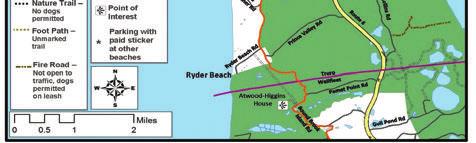

85 Town of Truro Bike and Walkways Committee Safety Brochure Outer Cape Bicycle and Pedestrian Master Plan - February 2017 Update 81


86 Bikers on Moors Road/Province Lands Road in Provincetown Cape Cod Rail Trail, South Wellfleet Adding a sharrow to roadway 82 Outer Cape Bicycle and Pedestrian Master Plan - February 2017 Update
87 Implementation The Outer Cape Bicycle and Pedestrian network will be implemented through a combination of efforts, acknowledging the various federal, state and town entities that own the land in question. To the greatest extent possible, improvements will be incorporated into existing transportation and infrastructure projects. Incorporating planned improvements into intersection upgrades and roadway maintenance projects in the study area will maximize cost effectiveness. Utility installations, road maintenance, bridge/culvert projects, and adjacent real estate development all may provide opportunities. Funding for specific segments of the Primary Route will also be pursued through MassDOT, Massachusetts DCR, and CCNS funding sources, with priority given to those segments with the greatest safety concerns. The Steering Committee should continue to play a role in promoting the project and moving it forward. Some portions of the network are already scheduled to be included in other transportation projects that have received funding. Cape Cod National Seashore has requested and may receive funding for improvements to the Head of the Meadow bike trail in Truro and creation of a trail on the dirt segment of the Old Kings Highway for MassDOT has committed to making Route 6 shoulder improvements in Truro and Wellfleet in 2017 as a short-term safety improvement. Intersection improvements at Route 6 and Main Street in Wellfleet are under design, with proposed construction in The towns of Wellfleet, Truro and Provincetown will play the key role in making improvements to Interim Primary and Secondary Routes. Towns will choose where to apply transportation funds on town-owned routes and how to design accommodations, but many may be addressed as part of resurfacing and striping projects. Outer Cape Bicycle and Pedestrian Master Plan - February 2017 update 83
88 PRIORITIeS Questions remain about where to locate the primary route through the central part of Wellfleet, and about the potential for a lane reduction in Truro and Provincetown. Both of these issues require additional analysis and funding opportunities should be pursued at regional and state levels to resolve these questions. The highest priorities for Primary Route implementation include segments/locations where no route alternative exists, and where there are greatest safety concerns due to high vehicle volumes and curb cut conflict points. The four priority segments are: Wellfleet Center Segment multi-use path along the existing railbed provides an alternative to the most heavily developed section of Route 6. (The design of the section between the railbed and the Main Street intersection requires further study as discussed on pp ) Wellfleet North Segment multi-use path on Route 6, east side, provides the only direct north-south route between Wellfleet and Truro. Truro Center Segment multi-use path on Route 6, east side, provides the best north-south route through central Truro. Beach Point Segment multi-use path on Route 6, west side, provides alternative to narrow Route 6A between Truro and Provincetown, as no shoulder exists on this portion of Route 6. (A potential lane reduction as discussed on pp would impact design and facilitate creation of a multi-use path in this area.) These priorities for study and implementation, as well as priorities for crossing improvements along Route 6, are highlighted on the Network Priorities graphic on the following page. Design of some of the priority crossing improvements could be affected by a Route 6 lane reduction. Secondary Route priorities are enumerated in the individual town sections, but summarized here. Wellfleet s priorities include pavement markings and possible shoulders along heavily travelled Ocean View Drive and LeCount Hollow Road, and Route 6 crossing improvements at Main Street and LeCount Hollow Road. Truro s priorities include Route 6 crossing improvements at Head of the Meadow Road and Standish Way, Stott s Crossing, and Castle Road, as well as lane markings along Head of the Meadow Road. Provincetown s priorities include climbing lanes on Bradford Street, a bicycle shoulder on Shank Painter Road, and Route 6 crossing improvements at Shank Painter Road and Conwell Street/Race Point Road. 84 Outer Cape Bicycle and Pedestrian Master Plan - February 2017 update


89 NETWORK PRIORITIES - Primary Route Segments, Areas of Further Study, & Crossing Improvements Area of Further Study Route 6 Lane Reduction in Truro and Provincetown Priority Segment - Beach Point Area Route 6 Multi-Use Path Priority Segment - Truro Center Area Route 6 Multi-Use Path Area of Further Study Wellfleet Center Area Primary Route Priority Segment - Wellfleet North Area Route 6 Multi-Use Path Priority Segment - Wellfleet Center Area Railbed Multi-Use Path Priority Segment Area for Further Study Crossing Improvement Outer Cape Bicycle and Pedestrian Master Plan - February 2017 update 85
90 COST estimates Relative cost estimates were developed for each segment considered as a possible primary route, and these conceptual level estimates were used to help compare the different route alternatives. Design details have not been developed for any of the proposed routes, so the estimates use several recent multi-use path and bicycle accommodation projects to estimate the unit cost of providing different accommodations. In some cases, the type of accommodation proposed in the Alternatives Development Report has been modified, and the cost estimate has been adjusted to reflect that change. The cost estimates in the tables on the following pages were based on the following averages: Multi-use path along existing roadway: $220 per linear foot Widen existing multi-use path: $160 per linear foot Multi-use path on existing railbed Hardened surface, unpaved $75 per linear foot Hardened surface, unpaved with structural base $125 per linear foot Paved $185 per linear foot Construct 4-foot paved bicycle shoulders: $110 per linear foot Share-the-Road markings and signage: $2 per linear foot Each cost estimate was then adjusted with a 40% increase for design and contingency charges. Additional elements such as crossing improvements, flashing beacons, and easements are not included in the Primary Route Cost Estimate. As an estimate of these additional costs, the 2010 Cape Cod National Seashore Bike Feasibility Study includes $1,500 per location for a striped crosswalk. FHWA identifies the cost for flashing beacons as $15,000 per location. The only potential easements discussed are near commercial properties in Provincetown center to create a path to the pier, and in Wellfleet along Route 6 near the Main Street intersection. In both cases, it is possible that a bicycle trail will provide benefits to existing businesses and be a desirable amenity that can be worked out with the property owner. 86 Outer Cape Bicycle and Pedestrian Master Plan - February 2017 update
91 PRIMARY ROUTE COST ESTIMATE Segment Proposed Route and Accommodation Cost Estimate Wellfleet $1.6 million Center Wellfleet North Truro South (Interim Primary Route) Truro South (Long Term Primary Route) Truro Center Truro North (Interim Primary Route) --Multi-use path along railbed, 1.75 miles, unpaved but hardened surface Option A --Marked bicycle shoulder along Old County/Old Kings Highway, 0.35 mile --Marked bicycle shoulder along Cahoon Hollow Rd (30,000 sq ft of disturbance estimated along 0.57 mile segment) Option B --Continue multi-use path along railbed 0.25 mile to Route 6, then follow Route 6 (east side) to Cahoon Hollow Road Option C --Identify another possible route through area Separated multi-use path along Route 6 (east side) 2.32 miles, from Cahoon Hollow Rd to Rose Rd --Marked Bicycle shoulder along Rose Rd/Collins Rd, 2.3 miles --Marked Bicycle shoulder along South Pamet Rd, 0.76 miles Separated multi-use path along Route 6 (east side) 2.3 miles, from Rose Rd to South Pamet Rd Separated multi-use path along Route 6 (east side) 2.47 miles, from South Pamet Rd to South Highland Rd --Marked Bicycle shoulder along South Highland Rd, 1.4 miles --Share the Road along Coast Guard Rd, 0.48 miles --Multi-use path along Old Kings Highway sand road, 0.8 miles --Existing Head of the Meadow bike trail, 1.9 miles --Share the Road along High Head Rd, 0.62 miles $280,000 (assumes 4 ft shoulder) $460,000 (assumes 4 ft shoulder) $415,000 NA $3.8 million $1.9 million (assumes 4 ft shoulder) $600,000 (assumes 4 ft shoulder) $3.7 million $4 million $1.1 million (assumes 4 ft shoulder) $7,000 $700,000 (CCNS) $2.2 million (CCNS) $9,000 (CCNS) Outer Cape Bicycle and Pedestrian Master Plan - February 2017 update 87
92 PRIMARY ROUTE COST ESTIMATE Segment Proposed Route and Accommodation Cost Estimate Truro North (Long Term Primary Route) Beach Point Provincetown (Interim Primary Route) Provincetown (Long Term Primary Route) Separated multi-use path along Route 6 (east side) 1.2 miles, from South Highland Rd to Highland Rd exit and underpass, then along Route 6 (west side) 2.2 miles from Highland Rd to Stott s Crossing. Separated multi-use path along Route 6 (west side) 1.7 miles, from Stott s Crossing to Provincetown town line --Separated multi-use path along Route 6 (west side) 0.85 miles --Marked bicycle shoulder along Snail Road, 0.1 mile to railroad bed --Multi-use path along railroad bed, hardened but unpaved surface, 0.96 miles to Howland St. Option A --Marked bicycle shoulder along Howland St. for 0.1 mile to Route 6 --Separated multi-use path along Route 6 for 0.45 miles to Conwell St. --Marked bicycle shoulder and share-the-road along Conwell St, Cemetery Rd, Alden St/ Bradford St and Standish St, 0.67 miles to Lopes Square. (This project is already underway) Option B --Marked bicycle shoulder along Harry Kemp Way to Conwell St. --Dedicated bike route on easement through Riley s parking lot to town center --Separated multi-use path along Route 6 (west/ south side) 2.25 miles from town line to Conwell St. --Separate multi-use path along Route 6 (west/ south side) 0.55 miles further to Shank Painter Rd, then crossing and along Route 6 (north/east side) 1.2 miles to Herring Cove Beach parking lot $5.5 million [lane diet would significantly reduce cost estimate] $2.8 million [lane diet would significantly reduce cost estimate] $1.4 million $81,000 (assumes 4 ft shoulder) $900,000 $81,000 (assumes 3 ft shoulder) $700,000 $1,000 $4,000 NA $3.7 million $2.8 million ($2 million CCNS) [lane diet would significantly reduce cost estimate] TOTAL INTERIM PRIMARY ROUTE $22.2 MILLION TOTAL LONG TERM PRIMARY ROUTE $28.3 MILLION 88 Outer Cape Bicycle and Pedestrian Master Plan - February 2017 update
93 POTeNTIaL FuNdING SOuRCeS FedeRaL HIGHWaY administration FuNdING POSSIBILITIeS To be eligible for federal funding, projects need to be listed on the Transportation Improvement Plan (TIP), the regional document which sets the basis for acquiring federal funds. Towns are encouraged to contact Cape Cod Commission transportation staff about developing strategies for funding projects. Federal Highway Administration, Surface Transportation Program s Enhancement Program (STP-E): funds bicycle and pedestrian facilities and preservation of abandoned railway corridors for bicycle/pedestrian trails. May be appropriate source for improvements to rail corridor segments of the Primary Route in Wellfleet and Provincetown. Surface Transportation Program (STP): funds construction of bicycle and pedestrian facilities primarily for transportation rather than recreation, and safety-related maps and brochures. May be appropriate source for construction of multi-use path segments along Route 6. Highway Safety Improvement (HSIP): funds projects that improve safety for bicyclists and pedestrians. May be appropriate source for construction of multi-use path segments along Route 6. Congestion Mitigation and Air Quality Improvement Program (CMAQ): funds projects that seek to increase use of non-motorized forms of transportation to reduce airborne pollutants. May be appropriate source for construction of multi-use path segments along Route 6 or for areas with congestion such as Provincetown and areas of Wellfleet. National Highway System: funds construction of bicycle and pedestrian facilities adjacent to highways within the National Highway System. May be appropriate source for constructing multi-use path segments along Route 6. Recreational Trails Program: funds construction and improvements to recreational trails. May be appropriate source for improvements to rail corridor segments. Safe Routes to School Program: funds projects that enable and encourage children to walk or bicycle to school. This program is administered by Mass- DOT and can provide training and consulting service to improve walking and bicycling safety. May be appropriate source for multi-use path segments near the Wellfleet Elementary School and Truro Central School. Federal Transit Administration Program: funds bicycle and pedestrian improvements related to accessing transit, including shelters, bike racks and signage. May be appropriate source for support facilities, especially where primary route passes through town centers and coincides with transit routes. Chapter 90/Local State Aid Program: funds local roadway improvement Outer Cape Bicycle and Pedestrian Master Plan - February 2017 update 89

94 projects and may be used as local match for other federal or state funding programs. May be appropriate source for interim primary route segments in Truro and Provincetown, and possibly for secondary route improvements. MassDOT Complete Streets Program: provides training and infrastructure funding opportunities for towns that participate in the program. Certified communities could be eligible for crossing upgrades, sidewalks, bicycle accommodations, or other elements of complete streets. Cape Cod Commission transportation staff can provide additional information. See also the program s website: NPS FedeRaL FuNdING POSSIBILITIeS Cape Cod National Seashore competes with other national park units for NPS funds and Federal Lands Highway funds for their roads, bicycle trails and other transportation improvements. National Seashore staff will request funds for each of the improvements recommended on NPS-owned roads to implement this plan; some follow-on project funds have already been requested. The OCBPMP was funded by the US Department of Transportation (US DOT) TRIP grant funds awarded to the NPS, which the NPS was able to spend on lands inside and outside the National Seashore. That grant source has expired. At this time, there is no other available transportation fund source that authorizes the NPS to fund projects on lands it does not hold title to. NPS staff will monitor whether future US DOT fund sources allow such activity so that they can compete for any forthcoming grant funds to advance OCBPMP projects, as available. Bikers along the Province Lands Bicycle Trail 90 Outer Cape Bicycle and Pedestrian Master Plan - February 2017 update
95 Appendix A Table of Road Characteristics Outer Cape Bicycle and Pedestrian Master Plan - February 2017 Update 91
96 92 POTENTIAL SECONDARY ROUTE CHARACTERISTICS - FOR DISCUSSION PURPOSES - Fall 2015 Length inside NPS Boundary (mile) Pavement Summer Vehicle LOS 1 Approx ROW (ft) 4 Approx Pavement Width (ft) 4 Speed Limit (mph) 3 Bicycle/Pedestrian Accommodation 2 Lane Configurati on Summer Pedestria n Volumes 1 Summer Bicycle Volumes 1 Summer Vehicle Volumes 1 Suggested Accommodation Segment Length Additional Description (south-north) Road Name Condition 5 Land/Road Owner Segment WELLFLEET No/minimal shoulder No sidewalks Fair Good Town of Wellfleet 2-lane undivided Low West Road Town line to Route miles Share the road W-AX 2-lane undivided 4' shoulders MassDOT 4 minimum shoulders both sides High Low Low 4 shoulders both sides; pilot removing center line on road LM M LM 2.4 miles West Road to LeCount Hollow Road W-A 1 Route 6 30 P Very Good Very Good No/minimal shoulder No sidewalks 2-Lane undivided Route 6 to beach 1.7 miles Marconi Beach Road Outer Cape Bicycle and Pedestrian Master Plan - February 2017 Update W-B NPS P Very Good Good No/minimal shoulder No sidewalks 2-Lane undivided 1 mile Share the road Marconi Beach Road to overlook (Marconi site) Marconi Site Rd W-C NPS 1- mile L M L 30 P *+ Very Good Good No/minimal shoulder No sidewalks 2-Lane undivided 0.85 mle Pedestrian/sidewalk Route 6 to Pilgrim Spring W-H Cove Road Town of Wellfleet LM Low Low 30 P Very Good Fair-Good No/minimal shoulder No sidewalks 2-Lane undivided 1-mile Share the road LM Low Pilgrim Spring Road Indian Neck W-H2 Indian Neck Town of Wellfleet Low Town of Wellfleet Very Good Fair-Good No/minimal shoulder No sidewalks 2-Lane undivided LM Med Low 2.15 miles Share the road Main Street to Ocean View Drive Long Pond Road WC *+ Good Very Good No/minimal shoulder No sidewalks 2-Lane undivided 0.66 mile 4 shoulders From CCRT- Ocean View Drive Lecount Hollow Road WC-3 Town of Wellfleet 1.5 M H M 30 P Good No/minimal shoulder No sidewalks 2-Lane undivided 1.72 miles 3 shoulders From LeCount Hollow to Cahoon Hollow Road Ocean View Drive WC-3 Town of Wellfleet M M M Very Good Good No/minimal shoulder No sidewalks 2-Lane undivided 2 miles Share the road From Ocean View Drive to Route 6 Cahoon Hollow Road WC-4 Town of Wellfleet M L L 30 P Good Fair-Good No/minimal shoulder No sidewalks 2-Lane undivided 1.35 miles Share the road Long Pond Road to Newcomb Hollow Beach parking lot Ocean View Drive W-E Town of Wellfleet 1.35 Med Med Med No/minimal shoulder No sidewalks Good Very Good Town of Wellfleet lane undivided 1.25 miles Share the road Route 6 Old County Road Pamet Point Road W-M Low Low Low Very Good Good - V. Good No/minimal shoulder No sidewalks 2-Lane undivided 2.71 miles Share the Road Commercial Street Griffin Island Road Kendrick Chequessett W-I Town of Wellfleet 0.35 LM LM LM Neck Bank Street 2-lane undivided 4-5' sidewalk Very Good Very Good Town of Wellfleet Main Street to Kendrick 0.6 miles Share the Road & W-J Med-High Med-High Med-High Commercial Very Good Fair No/minimal shoulder Sidewalk in portion 2-Lane undivided W-K Briar Lane Route 6 Main Street 0.5 miles Pedestrian/sidewalk Town of Wellfleet Low-Med Low Low 30 P 20 30* Fair-Good Good No/minimal shoulder 4-5 foot sidewalk on north side of Commerical 2-Lane undivided 0.24 miles Pedestrian/sidewalk From Main Street to Bank Street East Commercial W-L Town of Wellfleet Med High Med-High Med-High Fair-Good (to be raised for Herring River work) Town of Wellfleet (Bound Brook) No/minimal shoulder. Main & West Main have sidewalk lane undivided Share the road and minor safety improvements such as narrow lanes and fog line Low Med Low 3.35 miles Higgins Lane to Truro line Street Main Street, West Main, Pole Dike, Bound Brook 2 WN-1
97 Length inside NPS Boundary (mile) Pavement Condition 5 Land/Road Owner Summer Vehicle LOS 1 Approx ROW (ft) 4 Approx Pavement Width (ft) 4 Speed Limit (mph) 3 Bicycle/Pedestrian Accommodation 2 Summer Pedestria Lane Configuration n Summer Bicycle Volumes 1 Summer Vehicle Volumes 1 Suggested Accommodation Segment Length Additional Description (southnorth) Road Name Volumes 1 Segment TRURO P Very Good Fair-Good No/minimal shoulder No sidewalks 2-Lane undivided 3.3 miles Share the road Truro town line to Truro Center Road Old County & Depot Road Outer Cape Bicycle and Pedestrian Master Plan - February 2017 Update 93 TS-1 Town of Truro Low Med Low No/minimal shoulder. No sidewalk Town of Truro 0.60 miles Share the road Old County Road to beach Ryder Beach Road T-B Low Low Low 2-lane undivided Truro Conservation Trust, NPS 0.94 Pedestrian existing trail. Signage 1.2 miles RR bed from Bound Brook Island Road to Ryder Beach Road. Rail bed & Diana s Path T-A Town of Truro 1-mile 40 PF Very Good Low Low walking path Unpaved -sand trail Low Med Low-Medium 2-Lane undivided No/minimal shoulder Sidewalk in portion 1 mile Share the road Truro Center Road to Ballston beach South Pamet Road T-C P Very Good Fair-Good No/minimal shoulder. No sidewalk 0.65 miles 4' shoulders Old County Road Pamet Harbor T-D? Depot Road Town of Truro Low? Low Low 2-lane undivided No/minimal shoulder, No sidewalk NPS 0.86 Route 6 to bike path 0.9 mile Share the road Head of the Meadow T-F Low? Med Low 2-lane undivided No/minimal sholuder No sidewalk Town of Truro 2-lane undivided T-G Standish Way Route 6A to Route mle Share the road 2.10 miles Share the road From Truro Center Road to Route 6 north Truro Center Road/Castle Road TC-1 Low Med Low 2-lane undivided None Good Good Town of Truro MassDOT, Town of Truro miles 4' shoulder both sides From South Highland Rd to Route 6A TN-4 Highland Road Med Med Low 2-lane undivided None Very Good Fair From Highland Road to 3.92 miles 4 'shoulder both sides Commercial St/town line 3.92 miles 4 'shoulder both sides Med Med Med 2-lane undivided None Very Good Good Town of Truro Route 6A (Shore Road) TN-1 Notes: All scales are relative to the overall Outer Cape roads 1 - Based on traffic count data, field observations, and local knowledge 2 - Based on field observations. Conditions may vary throughour the corridor. 3 - Based on the speed limit noted in the MassDOT roadway inventory or P - Based on the posted speed limit or PF - based on prima facie speed limit is listed per MGL Chapter 90, Section Based on data in the MassDOT roadway inventory file, aerial photography, or on site measurement. 5 - Based on data from Cape-wide pavement management initiative
98 Length inside NPS Boundary (mile) 94 Provincetown POTENTIAL SECONDARY ROUTE CHARACTERISTICS - DRAFT FOR DISCUSSION PURPOSES March 2016 Pavement Condition 5 Land/Road Owner Summer Vehicle LOS 1 Approx ROW (ft) 4 Approx Pavement Width (ft) 4 Speed Limit (mph) 3 Bicycle/Pedestrian Accommodation 2 Lane Configurati on Summer Pedestria n Volumes 1 Summer Bicycle Volumes 1 Summer Vehicle Volumes 1 Suggested Accommodation Segment Length Additional Description (south-north) Road Name Segment PROVINCETOWN No/minimal shoulder. No sidewalk NPS, MassDOT 2-lane undivided LM Med Low 0.22 mile 4' shoulders Transfer Stationt - Route 6 Race Point Road Outer Cape Bicycle and Pedestrian Master Plan - February 2017 Update P-A Town of Provincetown 2-lane undivided Sidewalk in places Fair-Good Fair-Good 0.53 mile 4 shoulders Bradford Street Route 6 Shank Painter Road P-B MH High High Town of Provincetown No/minimal shoulder. No sidewalk Poor-Fair Poor-Fair 2-lane undivided 1.15 miles Share the road Commercial Street split to Conwell Street Bradford Street PE-6 Med High High Good New-Fair No/minimal shoulder No sidewalks 2-lane undivided 0.22 mile 5 bike lane Commercial Street to Bradford Street extension Moors Road (Provincelan ds Road) P-C MassDOT LM High MH MassDOT No/minimal shoulders. No sidewalks P-D Snail Road Route 6A to Route ' shoulders 2-lane undivided Sidewalk, with occasional 25 P Poor Very Good Town of Med High High 1-lane, 1-way interruption Provincetown 2-lane Town of Med High High undivided Intermittent sidewalks Poor-Fair Poor-Fair Provincetown 2-lane Town of Med High High High undivided Bike lane on west end Poor-Fair Poor-Fair Provincetown 1.2 miles Share the road Standish Street west end rotary Commercial Street PW mile Share the road Conwell Street - Prince Street Prince Street - Moors Road Bradford Street PW-2 1 mile 4' bike lane Bradford Street PW-2x 2-lane undivided east of Bradford St; the rest is 1- lane one-way 2.2 miles share the road; From Shore Road/town line to Standish Commercial Street PE-1 MassDOT, Town of Provincetown No shoulders. Sidewalknorth side Poor Very Good Med High High Notes: All scales are relative to overall Outer Cape roads 1 - Based on traffic count data, field observations, and local knowledge 2 - Based on field observations. Conditions may vary throughour the corridor. 3 - Based on the speed limit noted in the MassDOT roadway inventory or P - Based on the posted speed limit or PF - based on prima facie speed limit is listed per MGL Chapter 90, Section Based on data in the MassDOT roadway inventory file, aerial photography, or on site measurement. 5 - Based on data from Cape-wide pavement management initiative
99 Appendix B Potential Primary Route Alternatives Draft Map Outer Cape Bicycle and Pedestrian Master Plan - February 2017 Update 95

100 96 Outer Cape Bicycle and Pedestrian Master Plan - February 2017 Update
101 Appendix C Memo to Public Safety Officials regarding Route 6 Lane Reduction Outer Cape Bicycle and Pedestrian Master Plan - February 2017 Update 97
102 Memorandum DATE: APRIL 29, 2016 TO: FROM: RE: KYLE TAKAKJIAN, TRURO CHIEF OF POLICE DAVID GARDNER, PROVINCETOWN ASSISTANT TOWN MANAGER MARTHA HEVENOR, PLANNER LANE REDUCTION At our meetings last month with town staff members on the Outer Cape Bicycle and Pedestrian Master Plan (OCBPMP), you had requested information on potential impacts to traffic flow from lane reduction along the four-lane section of Route 6 in Truro and Provincetown. In response to your request, CCC transportation staff conducted an analysis of a lane diet in this location, as provided in the attached document. Please feel free to contact Patrick Tierney (ptierney@capecodcommission.org) if you have any questions about the analysis. Thank you for your time and input on the OCBPMP. Please let me know if you have any questions or would like further information about the project. 98 Outer Cape Bicycle and Pedestrian Master Plan - February 2017 Update
103 Introduction As part of its discussion of route alternatives, the Outer Cape Bicycle and Pedestrian Master Plan steering committee members requested that Cape Cod Commission (CCC) staff explore the concept of a lane diet for the four-lane section of Route 6 in Truro and Provincetown to determine its feasibility and potential to reduce construction costs and natural resource/habitat impacts from installation of a separated multi-use path within the Route 6 right-of-way. A lane diet in this location could result in a two-lane highway with one lane of travel in each direction, or a three-lane highway with two lanes in one direction. Existing Conditions CCC performed traffic counts at multiple points along the roadway as presented in the attached table. The table shows the highest measured directional traffic volumes, summer average daily traffic volumes, and 85 th percentile speeds on Route 6 from North Eastham to Provincetown. On the four lane section of Route 6, between Shore Road in Truro and the Provincetown/Truro town line, the highest measured traffic volumes in the summer months ranged from 1,018 to 618 vehicles per hour in one direction. On the four lane section of Route 6 between the town line and Herring Cove Beach in Provincetown, the highest measured traffic volumes in the summer months ranged from 852 to 190 vehicles per hour in one direction. (The analysis uses summer traffic volumes as these are the peak conditions and recent counts are available. Recent year round counts are not available, but observation and past data shows that they are significantly lower.) Speed measurements on the four lane sections show 85 th percentile speeds as high as 63 mph. The posted speed limit is 50 mph. Measurements show top speeds of over 65 miles per hour, and town officials have identified speeding as a problem. The four-lane sections of Route 6 do not provide bicycle or pedestrian accommodations. The two-lane sections in Truro and Wellfleet have 6 to 8 foot paved shoulders that are frequently used by bicycles and pedestrians. Land Reduction Feasibility and Impacts The Federal Highway Administration (FHWA) states that typically the traffic threshold for considering lane reduction from four lanes to two is 875 vehicles per hour in one direction or average daily traffic as high as 24,000 vehicles per day in both directions 1. This is a guideline, not a standard, and does not account for special conditions/features such as seasonal population swings or geography. As shown in the graph and table attached, Route 6 in Truro has a maximum directional volume higher than the FHWA hourly volume threshold. Vehicle volumes for Route 6 in Provincetown do not exceed the thresholds. The summer average daily traffic volumes for the entire four lane segment fall below the daily volume threshold of 24,000 vehicles. In addition, sections of Route 6 that have two lanes in Truro and Wellfleet show higher traffic volumes than those that have four lanes in North Truro and Provincetown. Decreasing the number of lanes could impact vehicle flow during peak summer hours because the peak hour volumes are near or above the feasibility threshold. Outside of the peak summer hours and the Outer Cape Bicycle and Pedestrian Master Plan - February 2017 Update 99 1
104 summer months, traffic volumes are significantly lower than the thresholds. Traffic flow would likely be similar to the two lanes sections of Route 6 in Truro and Wellfleet. One question raised is the impacts to level of service at intersections. With appropriate intersection design, including carrying sufficient through lanes and incorporating turning lanes with sufficient storage, impacts may be mitigated. In relation to roadway speeds, FHWA states that municipalities typically reduce the number of lanes to reduce extreme and 85 th percentile speeds. Case studies and traffic simulation suggest that the 85 th percentile could decrease between 3 to 5 mph and the number of speeders that violate the posted speed limit could decrease by 7 percent. Actual impacts will vary based on abutting land use and roadway geometry. A review of safety literature suggests that the number of crashes is typically reduced when a four lane road is reduced to two or three lanes. Specific case studies include reduction on roadways with turning lanes, low density and segments with 8 or fewer intersections per mile 2. Since lane reductions typically result in lower speeds, implementation could also have positive impacts on crash severity. FHWA states that a difficult aspect of implementing a lane reduction is public perception. One method to address concern could be to conduct a trial period. Sometimes lane reduction occurs during construction and a trial marking plan could be consistent with previous roadway projects. The impacts to congestion can be observed rather than estimated and the public gets a chance to drive the roadway under the proposed conditions. To have a positive impact to public perception, the trial period should last a reasonable amount of time, such that perception can adjust to the change and react to the impacts. The discontinued travel lanes could allow for designated space for bicycles and pedestrians and/or include a shoulder, as on the two lane portions of Route 6 in Wellfleet and Truro. A shoulder could allow vehicles to maneuver around vehicles turning left off Route 6. Bicycles could use the shoulder, as occurs on the two lane sections in Truro and Wellfleet. As a longer term project, a multi-use path physically removed from the travel lanes and shoulder is proposed. A lane reduction would allow the new path to be closer to the roadway centerline, minimizing the impacts to local ecology. Conclusion It is appropriate to consider a reduction in lanes on Route 6 in Truro and Provincetown. The disadvantages are negligible and there are reasonable advantages. Benefits include reducing speeding and providing space for bicycle and pedestrian accommodation. The peak summer directional roadway volumes on the four lane section of Route 6 in Truro are near or above the suggested maximum hourly threshold from FHWA; however, vehicle volumes for Route 6 in Provincetown do not exceed the thresholds, and the summer average daily traffic volumes for the entire four-lane segment fall below the daily volume threshold of 24,000 vehicles. In addition, sections of Route 6 with two lanes in Truro and Wellfleet show higher traffic volumes than those with four lanes, demonstrating that a two-lane configuration can accommodate the traffic levels Outer Cape Bicycle and Pedestrian Master Plan - February 2017 Update
105 Location Town Mile from Start Count Start Date SB Peak Hour 3 Highest measured southbound peak hour volume 3 NB Peak Hour 3 Highest measured northbound peak hour volume 3 Configuration Historical estimated 4pm-5pm peak directional traffic volume 3 Historical estimated summer average daily traffic 4 85th percentile speed 3 Rt 6 W of Shank Painter Road Provincetown 0 8/11/2015 5pm am lane divided Rt 6 W of Conwell Provincetown /11/2015 5pm am lane divided Rt 6 E of Conwell Provincetown /22/2009 4pm pm lane divided Rt 6 E of Howland Provincetown /11/2015 3pm am lane divided Rt 6 TL Provincetown/Truro /11/ am pm 670 Rt 6 N of Rt 6A Truro 7.2 8/4/2014 4pm 882 5pm 1018 Rt 6 S of Rt 6A Truro 7.7 8/7/2012 5pm pm 1053 Rt 6 N of Truro Central School Rt 6 S of Union Field Rd Rt 6 S of Prince Valley Rd Truro /1/2006 5pm pm 896 Truro /16/2012 4pm pm 787 Truro /20/2009 4pm pm 844 Rt 6 TL Truro/Wellfleet /13/2015 4pm 732 1pm 881 Rt 6 S of Long Pond Road Rt 6 S of Main Street Rt 6 S of Lecount Hollow Road Rt 6 N of Lieutenant Island Rd Wellfleet /19/2014 4pm pm 923 Wellfleet /19/2014 4pm am 1210 Wellfleet /19/2014 4pm am 1100 Wellfleet /13/2009 4pm pm 1272 Rt 6 TL Wellfleet/Eastham 20 7/13/2015 6pm pm 1319 Rt 6 N of Nauset Road Eastham /13/2015 5pm am lane undivided 4 lane undivided 2 lane undivided 2 lane undivided 2 lane undivided 2 lane undivided 2 lane undivided 2 lane undivided 2 lane undivided 2 lane undivided 2 lane undivided 2 lane undivided 4 lane undivided measured through the Cape Cod Commission Traffic Counting Program. Data sheets are available by request. 4 data presented in the Cape Cod Commission Traffic Counting Web Viewer. 3 Outer Cape Bicycle and Pedestrian Master Plan - February 2017 Update 101
106 Route 6 Highest Measured Directional Volume Rt 6 TL Provincetown /Truro Rt 6A at Rt 6 Truro Rt 6 TL Truro/Wellfleet Rt 6 TL Wellfleet/Eastham Highest measured northbound peak hour volume Highest measured southbound peak hour volume Linear (Highest measured northbound peak hour volume) Linear (Highest measured southbound peak hour volume) 4 lanes blue shade Two lanes unshaded The graph to the left shows the highest measured directional volume in August or July on Route 6 in the Outer Cape. The data points are separated by geographical distance, starting west of Shank Painter Road in Provincetown and ending north of Nauset Road (north end) in Eastham. The gray dots show traffic volumes in the northbound direction and the yellow dots show traffic volumes in the southbound direction. Major points along the roadway are shown with vertical black division lines on the graph. Both data sets are summarized by linear trend lines in the corresponding color. The data in this graph is present in the table attached. 4 Peak Hour Volume 102 Outer Cape Bicycle and Pedestrian Master Plan - February 2017 update
107 Outer Cape Bicycle and Pedestrian Master Plan - February 2017 Update 103

108 Cape Cod Commission 3225 Main Street, PO Box 226 Barnstable, Ma a department of Barnstable County Regional Government, Massachusetts
Outer Cape Bicycle & Pedestrian Master Plan. PUBLIC WORKSHOP #2 March 26, 2015
 Outer Cape Bicycle & Pedestrian Master Plan PUBLIC WORKSHOP #2 March 26, 2015 Introductions TODAY S DISCUSSION PRESENTATION: Project Background : Where have we been? Where are we now? Steering Committee
Connecting Town Centers to the Regional Pedestrian & Bicycling Network on Cape Cod. July 2014
 Connecting Town Centers to the Regional Pedestrian & Bicycling Network on Cape Cod July 2014 Table of Contents Table of Contents... 1 Introduction... 2 Background and Purpose... 2 Guide to Terminology...
Active Transportation Facility Glossary
 Active Transportation Facility Glossary This document defines different active transportation facilities and suggests appropriate corridor types. Click on a facility type to jump to its definition. Bike
G AT E WAY PLAN. Community BRIEFING KIT GATEWAY BIKE
 G AT E WAY PLAN GATEWAY BIKE Community BRIEFING KIT PLAN August 2016 TABLE OF CONTENTS INTRODUCTION... 1 THE BENEFITS OF A BIKEABLE COMMUNITY... 2 ECONOMY...2 SAFETY...3 HEALTH...3 HOUSEHOLD SPENDING...3
Outer Cape Bicycle and Pedestrian Master Plan
 Outer Cape Bicycle and Pedestrian Master Plan Alternatives Development Report May 2016 Prepared by the Cape Cod Commission in coordination with Cape Cod National Seashore (Cooperative Agreement #P14AC00162)
CONNECTING PEOPLE TO PLACES
 CONNECTING PEOPLE TO PLACES 82 EAST BENCH MASTER PLAN 07 Introduction The East Bench transportation system is a collection of slow moving, treelined residential streets and major arteries that are the
MAG Town of Cave Creek Bike Study Task 6 Executive Summary and Regional Significance Report
 Page 1 MAG Town of Cave Creek Bike Study Task 6 Executive Summary and Regional Significance Report August 1, 2012 MAG Project #481 Page 2 Task 6 Executive Summary and Regional Significance Report Introduction
Chapter 7. Transportation. Transportation Road Network Plan Transit Cyclists Pedestrians Multi-Use and Equestrian Trails
 Chapter 7 Transportation Transportation Road Network Plan Transit Cyclists Pedestrians Multi-Use and Equestrian Trails 7.1 TRANSPORTATION BACKGROUND The District of Maple Ridge faces a number of unique
Route 28 Critical Locations Bicycling Network Connectivity November 2017
 Route 28 Critical Locations Bicycling Network Connectivity November 2017 Nobska Light Chatham Light Prepared by Cape Cod Commission staff on behalf of the Cape Cod Metropolitan Planning Organization and
Living Streets Policy
 Living Streets Policy Introduction Living streets balance the needs of motorists, bicyclists, pedestrians and transit riders in ways that promote safety and convenience, enhance community identity, create
Corpus Christi Metropolitan Transportation Plan Fiscal Year Introduction:
 Introduction: The Safe, Accountable, Flexible, Efficient Transportation Equity Act: A Legacy for Users (SAFETEA-LU) has continued the efforts started through the Intermodal Surface Transportation Efficiency
Perryville TOD and Greenway Plan
 Perryville TOD and Greenway Plan Greenway Glossary Pathway: A bicycle and pedestrian path separated from motorized vehicular traffic by an open space, barrier or curb. Multi-use paths may be within the
Solana Beach Comprehensive Active Transportation Strategy (CATS)
") Solana Beach Comprehensive Active Transportation Strategy (CATS) 3.0 Goals & Policies The Solana Beach CATS goals and objectives outlined below were largely drawn from the Solana Beach Circulation Element
Solana Beach Comprehensive Active Transportation Strategy (CATS) 3.0 Goals & Policies The Solana Beach CATS goals and objectives outlined below were largely drawn from the Solana Beach Circulation Element
5. RUNNINGWAY GUIDELINES
 5. RUNNINGWAY GUIDELINES These guidelines should be considered collectively when making runningway decisions. A runningway is the linear component of the transit system that forms the right-of-way reserved
Sandwich Pedestrian/Bicycle Planning
 Sandwich Pedestrian/Bicycle Planning Improved Pedestrian and Bicycle Connections with the Cape Cod Canal Multi-use Path February 2014 Table of Contents Introduction... 1 Background... 1 Study Goals...
Bikeway action plan. Bicycle Friendly Community Workshop March 5, 2007 Rochester, MN
 Bikeway action plan Summary The was held on March 5, 2007 at the Rochester Mayo Civic Center. The workshop was hosted by Rochester-Olmsted County Planning Department in collaboration with the League of
Appendix 3 Roadway and Bike/Ped Design Standards
 Appendix 3 Roadway and Bike/Ped Design Standards OTO Transportation Plan 2040 4/20/2017 Page A3-1 Adopted Standards The adopted OTO Design Standards and Major Thoroughfare Plan are contained herein.
Duwamish Way-finding and CTR Report
 V. North Tukwila When the North Tukwila Manufacturing and Industrial Center was designated in 1992 as part of the region s land use and transportation plan, the plan called for the area to set a light-rail
o n - m o t o r i z e d transportation is an overlooked element that can greatly enhance the overall quality of life for the community s residents.
 N o n - m o t o r i z e d transportation is an overlooked element that can greatly enhance the overall quality of life for the community s residents. 84 Transportation CHAPTER 11 INTRODUCTION Transportation
NM-POLICY 1: Improve service levels, participation, and options for non-motorized transportation modes throughout the County.
 Transportation PRINCE WILLIAM COUNTY 2008 COMPREHENSIVE PLAN NON-MOTORIZED PLAN CONTENTS Goals, Policies, and Action Strategies Table 4 (Bike Facility Classifications and Descriptions) Table 5 (Bike Facility
Non-Motorized Transportation 7-1
 Non-Motorized Transportation 7-1 Transportation facilities no longer mean just accommodating a vehicle powered by a combustion engine. Pedestrian and non-motorized facilities are important modes of travel
Planning Guidance in the 2012 AASHTO Bike Guide
 Planning Guidance in the 2012 AASHTO Bike Guide Presentation by: RJ Eldridge Peter Lagerwey August 22, 2012 WEBINAR 2: PLANNING GUIDANCE IN THE 2012 AASHTO BIKE GUIDE Today s Webinar Significant Updates
Chapter 3 DESIGN SPECIFICATIONS
 Brampton PathWays Planning and Design Guidelines 27 Chapter 3 DESIGN SPECIFICATIONS 3.1 CLASS 1 MULTI-USE PATH Off-road multi-use trails are the backbone of the Brampton PathWays Network. They are typically
City of Novi Non-Motorized Master Plan 2011 Executive Summary
 City of Novi Non-Motorized Master Plan 2011 Executive Summary Prepared by: February 28, 2011 Why Plan? Encouraging healthy, active lifestyles through pathway and sidewalk connectivity has been a focus
EXECUTIVE SUMMARY. Vision
 Vision Walking and bicycling in Salt Lake City will be safe, convenient, comfortable, and viable transportation options that connect people to places, foster recreational and economic development opportunities,
Exhibit 1 PLANNING COMMISSION AGENDA ITEM
 Exhibit 1 PLANNING COMMISSION AGENDA ITEM Project Name: Grand Junction Circulation Plan Grand Junction Complete Streets Policy Applicant: City of Grand Junction Representative: David Thornton Address:
West Dimond Blvd Upgrade Jodhpur Street to Sand Lake Road
 West Dimond Blvd Jodhpur St to Sand Lake CSS Transportation Project Summary Municipality of Anchorage Project # 05 005 Project Manager: John Smith, P.E. (MOA PM&E) Project Administrator: Julie Makela,
General Design Factors
 Chapter 3: 3-1.0 Introduction General Design Factors Mn/DOT s goals include encouraging and accommodating safe bicycling. From a design perspective, these goals are achieved by first having an understanding
Proposed. City of Grand Junction Complete Streets Policy. Exhibit 10
 Proposed City of Grand Junction Complete Streets Policy Exhibit 10 1 City of Grand Junction Complete Streets Policy Vision: The Complete Streets Vision is to develop a safe, efficient, and reliable travel
CITY OF COCOA BEACH 2025 COMPREHENSIVE PLAN. Section VIII Mobility Element Goals, Objectives, and Policies
 CITY OF COCOA BEACH 2025 COMPREHENSIVE PLAN Section VIII Mobility Element Goals, Objectives, and Policies Adopted August 6, 2015 by Ordinance No. 1591 VIII MOBILITY ELEMENT Table of Contents Page Number
Land Use Bicycle Spaces Required Type Residential
 SAMPLE ORDINANCES AND RESOLUTIONS APPENDIX B SAMPLE BICYCLE PARKING ORDINANCE Land Use Bicycle Spaces Required Type Residential Single Family/Two Family N/A N/A Apartment/Townhome 1 per unit plus 6 space
Who is Toole Design Group?
 2018 AASHTO Bike Guide Status Update NCHRP 15 60 Amalia Leighton Cody, PE, AICP & Kenneth Loen, PE Washington APWA October 4, 2018 Who is Toole Design Group? TDG is a full service engineering, planning
Off-road Trails. Guidance
 Off-road Trails Off-road trails are shared use paths located on an independent alignment that provide two-way travel for people walking, bicycling, and other non-motorized users. Trails specifically along
BICYCLE FACILITIES & PROGRAMS
 CHAPTER 5 BICYCLE FACILITIES & PROGRAMS This component reviews existing bicycle facilities and issues associated with bicycling in the region. The chapter also presents the regional bicycle route system
Vision: Traditional hamlet with an attractive business/pedestrian friendly main street connected to adjacent walkable neighborhoods
 N D. Focus Area II Vision: Traditional hamlet with an attractive business/pedestrian friendly main street connected to adjacent walkable neighborhoods Transit Road Focus Area II is located in the Hamlet
RESOLUTION NO ?? A RESOLUTION OF THE CITY OF NEPTUNE BEACH ADOPTING A COMPLETE STREETS POLICY
 RESOLUTION NO. 2018-?? A RESOLUTION OF THE CITY OF NEPTUNE BEACH ADOPTING A COMPLETE STREETS POLICY WHEREAS, safe, convenient, and accessible transportation for all users is a priority of the City of Neptune
Clackamas County Comprehensive Plan
 ROADWAYS The County s road system permits the movement of goods and people between communities and regions, using any of a variety of modes of travel. Roads provide access to virtually all property. They
ACTIVE TRANSPORTATION
 ACTIVE TRANSPORTATION Mobility 2040 Supported Goals Improve the availability of transportation options for people and goods. Support travel efficiency measures and system enhancements targeted at congestion
TOWN OF PORTLAND, CONNECTICUT COMPLETE STREETS POLICY
 TOWN OF PORTLAND, CONNECTICUT COMPLETE STREETS POLICY I. VISION, GOALS & PRINCIPLES VISION To improve the streets of Portland making them safer and more accessible for all users including pedestrians,
Chapter 5 Future Transportation
 Chapter 5 Future Transportation The Future Land Use Plan identifies the desired land use designations. The land uses desired for Crozet depend, in large part, on the success of the transportation system,
Chapter 2: Standards for Access, Non-Motorized, and Transit
 Standards for Access, Non-Motorized, and Transit Chapter 2: Standards for Access, Non-Motorized, and Transit The Washtenaw County Access Management Plan was developed based on the analysis of existing
Public Information Centre
 WELCOME Public Information Centre Father Tobin Road Lougheed Middle School - Library Wednesday November 7, 2012 7:00 p.m.to 9:00 p.m. Please sign in Neighbourhood Traffic Calming Guide Background The City
Lee s Summit Road Improvement Study Public Open House June 7, 2007 Summary of Comment Card Responses
 Lee s Summit Road Improvement Study Public Open House June 7, 2007 Summary of Comment Card Responses Introduction At the Lee s Summit Road Improvement Study Public Open House held Thursday, June 7, 2007
Appendix T CCMP TRAIL TRAFFIC & TRANSPORTATION DESIGN STANDARD
 Appendix T CCMP 3.3.4 TRAIL TRAFFIC & TRANSPORTATION DESIGN STANDARD 3.3.4 Trail Traffic and Transportation Design Multi-use trails have certain design standards, which vary depending on the agency that
Broad Street Bicycle Boulevard Design Guidelines
 Broad Street Bicycle Boulevard Design Guidelines Building from the strategies introduced in the 2013 Bicycle Transportation Plan and community input received thus far, City Transportation Staff have identified
CHAPTER 3: Vision Statement and Goals
 Davidson Walks & Rolls: Active Transportation Master Plan CHAPTER 3 Contents: Overview Vision Statement Measurable Goals Public Outreach CHAPTER 3: Vision Statement and Goals Overview The vision statement
Cyclists and Bikeways: What s your match? A guide to bikeway options for a variety of cyclists
 Cyclists and Bikeways: What s your match? guide to bikeway options for a variety of cyclists The workshop and this resource were made possible by funding from the Province of Ontario via the Ministry of
Anne Arundel County BICYCLE, PEDESTRIAN, TRANSIT ASSESSMENT GUIDELINES
 Anne Arundel County BICYCLE, PEDESTRIAN, TRANSIT ASSESSMENT GUIDELINES December 2018 TABLE OF CONTENTS I. Executive Summary 3 II. When Is A Bicycle Pedestrian Transit Assessment (BPTA) Required? 4 III.
Circulation in Elk Grove includes: Motor vehicles, including cars and trucks
 Circulation, as it is used in this General Plan, refers to the many ways people and goods move from place to place in Elk Grove and the region. Circulation in Elk Grove includes: Motor vehicles, including
Bicycle Facilities Planning
 Bicycle Facilities Planning Overview Types of Cyclists Purpose for Riding Types of Facilities Bike Lanes Bicycle Boulevards Cycle Tracks Intersections Signals Signing and Marking Discussion Types of Bicyclists
East Burke Transportation, Safety and Capacity Improvements
 East Burke Transportation, Safety and Capacity Improvements The purpose of this project is to increase mobility and improve safety for pedestrians, cyclists, and motor vehicles along VT Route 114 in the
City of Wayzata Comprehensive Plan 2030 Transportation Chapter: Appendix A
 A1. Functional Classification Table A-1 illustrates the Metropolitan Council s detailed criteria established for the functional classification of roadways within the Twin Cities Metropolitan Area. Table
Tonight is for you. Learn everything you can. Share all your ideas.
 Strathcona Neighbourhood Renewal Draft Concept Design Tonight is for you. Learn everything you can. Share all your ideas. What is Neighbourhood Renewal? Creating a design with you for your neighbourhood.
Physical Implications of Complete Streets Policies
 Presentation Overview Physical Implications of Complete Norm Cox, ASLA, LLA Landscape Architect Ann Arbor, Michigan, 10:45 to Noon What Are Complete Streets? What Matters to Bicyclists and Pedestrians
PBIC Webinar. How to Create a Bicycle Safety Action Plan: Planning for Safety [IMAGE] Oct. 2, 2014, 2 pm
![PBIC Webinar. How to Create a Bicycle Safety Action Plan: Planning for Safety [IMAGE] Oct. 2, 2014, 2 pm](/thumbs/86/93953441.jpg "PBIC Webinar. How to Create a Bicycle Safety Action Plan: Planning for Safety [IMAGE] Oct. 2, 2014, 2 pm") PBIC Webinar How to Create a Bicycle Safety Action Plan: Planning for Safety [IMAGE] Bill Schultheiss, Vice President, Toole Design Peter Lagerwey, Regional Director, Toole Design Oct. 2, 2014, 2 pm Today
PBIC Webinar How to Create a Bicycle Safety Action Plan: Planning for Safety [IMAGE] Bill Schultheiss, Vice President, Toole Design Peter Lagerwey, Regional Director, Toole Design Oct. 2, 2014, 2 pm Today
Bicycle and Pedestrian Connectivity Study. Old Colony Planning Council
 Bicycle and Pedestrian Connectivity Study Old Colony Planning Council Outline Why consider bike/peds in road designs? Why are measures needed? Connecting Land Use with Transportation Evaluation Tools:
Eliminating Transit Barriers. A review of bus stops and access to them on Cape Cod
 Eliminating Transit Barriers A review of bus stops and access to them on Cape Cod October 2016 Executive Summary Pedestrian access to bus stops was identified as a key impediment for transit users on
St. Francis Drive through the City of Santa Fe Corridor Study
 VII. ENGINEERING AND ENVIRONMENTAL EVALUATION TRAIL CONNECTIVITY In the southern portion of the Corridor there is a lack of a sidewalk, trail or bicycle facility within the right-ofway. However, the City
Madison Urban Area and Dane County. Bicycle Transportation Plan Summary. September Introduction. Bicycle Plan Scope and Planning Process
 Bicycle Transportation Plan Summary Madison Urban Area and Dane County Introduction September 2000 Bicycling is an important mode of transportation in the Madison urban area and countywide that is available
Comments EXECUTIVE SUMMARY
 Comments 1. Under any Alternatives, MCDOT should provide better at-grade pedestrian crossing of Georgia Avenue and Forest Glen Road, including improved crosswalks with wider medians and adequate signal
REGIONAL BICYCLE AND PEDESTRIAN DESIGN GUIDELINES
 REGIONAL BICYCLE AND PEDESTRIAN DESIGN GUIDELINES November 16, 2011 Deb Humphreys North Central Texas Council of Governments Bicycle and Pedestrian Advisory Committee Snapshot of the Guide 1. Introduction
4 Goals, Objectives & Actions
 Chapter4 4 This chapter presents goals, objectives, and recommended actions to support the vision of making Overland Park a safer and easier place to ride a bicycle. 35 4.1 Recommendations Structure The
5 CIRCULATION AND STREET DESIGN
 5 CIRCULATION AND STREET DESIGN This chapter describes circulation and streetscape improvements proposed for the Northwest Chico Specific Plan Area. It includes detailed design specifications for existing
CITY OF ELKO BICYCLE AND PATHWAY PLAN
 CITY OF ELKO BICYCLE AND PATHWAY PLAN INTRODUCTION: The City of Elko is intended to provide the basic framework for the development of a functional bicycle and pathway system for the community with connections
Transportation Master Plan Advisory Task Force
 Transportation Master Plan Advisory Task Force Network Alternatives & Phasing Strategy February 2016 BACKGROUND Table of Contents BACKGROUND Purpose & Introduction 2 Linking the TMP to Key Council Approved
Bicycle Boulevards and Neighborhood Greenways
 Bicycle Boulevards and Neighborhood Greenways Traffic Safety is Improving for Everyone 90 80 70 60 50 40 30 20 10 0 PORTLAND: TOTAL TRAFFIC FATALITIES 1986-2008 1986 1987 1988 1989 1990 1991 1992 1993
Table of Contents Introduction. 2 Purpose of the Plan...2 The Benefits of Walking and Bicycling...3 Vision and Goals of the Plan...
 BICYCLE AND This plan was created through a grant from the Healthy Communities Program with the cooperation of the City of Cynthiana, Cynthiana Main Street, Cynthiana-Harrison County-Berry Joint Planning
Agenda. Overview PRINCE GEORGE S PLAZA METRO AREA PEDESTRIAN PLAN
 PRINCE GEORGE S PLAZA METRO AREA PEDESTRIAN PLAN May 28, 2008 Agenda Welcome and introductions Project overview and issue identification Planning context and strengths Design challenges and initial recommendations
Kelowna On the Move. Pedestrian and Bicycle Master Plan
 Kelowna On the Move Pedestrian and Bicycle Master Plan Executive Summary April 2016 Purpose of the Plan The Pedestrian and Bicycle Master Plan identifies infrastructure, planning, and policy requirements
Classification Criteria
 SCHEDULE D TO RECOMMENDED OFFICIAL PLAN AMENDMENT NO. 40 SCHEDULE C-4 Road Criteria Criteria Traffic Service Objective Land Service/Access Typical Daily Traffic Volume Flow characteristics Travel Speed
Bridgewater Complete Streets Prioritization Plan and Pedestrian Safety Assessment
 Bridgewater Complete Streets Prioritization Plan and Pedestrian Safety Assessment Presented by Luciano Rabito Manager of Complete Streets Presented to Bridgewater, MA Wednesday, April 26, 2017 6:30 P.M.
Regional Transportation Needs Within Southeastern Wisconsin
 Regional Transportation Needs Within Southeastern Wisconsin #118274 May 24, 2006 1 Introduction The Southeastern Wisconsin Regional Planning Commission (SEWRPC) is the official areawide planning agency
Chapter VISION, MISSION, AND GOALS AND OBJECTIVES. Vision. Mission. Goals and Objectives CONNECTING COMMUNITIES ACROSS THE ST.
 VISION, MISSION, AND GOALS AND OBJECTIVES Chapter 3 The Plan s vision, mission, and goals and objectives were developed through a series of interactive exercises with the Citizens Advisory Committee (CAC)
Rochester Downtown Bicycle Study 2009
 Rochester Downtown Bicycle Study 2009 Relationship of ROCOG Long Range Transportation Plan to Rochester Comprehensive Plan Regional Long Range Transportation Plan (LRTP) is prepared under the auspices
Trails that Transform: The Economic Impact of Bicycle Tourism
 Trails that Transform: The Economic Impact of Bicycle Tourism September 2016 Economic Growth Summit Alta Planning + Design Nation s leading team of bicycle, pedestrian, greenways, and trails planning and
Cycle Track Design Best Practices Cycle Track Sections
 Design Best Practices Sections It is along street segments where the separation and protection methods of cycle tracks offer more comfort than conventional bicycle lanes, and are more attractive to a wide
City of Birmingham Draft Multi-modal Transportation Plan
 City of Birmingham Draft Multi-modal Transportation Plan City Commission Public Hearing Monday, November 25, 2013 7:30 pm Norman Cox, PLA, ASLA The Greenway Collaborative, Inc. Ann Arbor, Michigan The
Winnipeg Walk Bike Projects Downtown Tire Talk - Summary
 Winnipeg Walk Bike Projects Downtown Tire Talk - Summary Downtown Projected Bike Lane System Connecting The Forks to the Exchange District (Fort Street, Garry Street & The Forks to Assiniboine Connection)
CITY OF BLOOMINGTON COMPLETE STREETS POLICY
 CITY OF BLOOMINGTON COMPLETE STREETS POLICY POLICY OBJECTIVE: The City of Bloomington will enhance safety, mobility, accessibility and convenience for transportation network users of all ages and abilities,
INTRODUCTION THOROUGHFARE SYSTEM CLASSIFICATIONS
 INTRODUCTION The thoroughfare plan will assist public officials in the development of a specialized system for efficient and safe movement of vehicular traffic while minimizing potential conflicts with
Chapter 5. Complete Streets and Walkable Communities.
 Chapter 5. Complete Streets and Walkable Communities. 5.1 Description of Complete Streets. Cities throughout the world, and specifically the United States, are coming to embrace a new transportation and
INDOT Complete Streets Guideline & Policy
 INDOT Complete Streets Guideline & Policy INTRODUCTION The Complete Streets guidelines build upon multiple efforts and promote a multimodal transportation system that is integrated and sustains land use
What Is a Complete Street?
 Session 5 Charleen Zimmer, AICP, Zan Associates May 5-7, 2010 What Is a Complete Street? May 2010 5-1 Not a Complete Street More of a Complete Street May 2010 5-2 Benefits of Complete Streets Safety for
Bar Harbor Route 3 Gateway Project Advisory Committee September 21, 1-3 PM Atlantic Oakes Hotel Minutes
 Bar Harbor Route 3 Gateway Project Advisory Committee September 21, 1-3 PM Atlantic Oakes Hotel Minutes Attending: Dick Cough, Edith Milbury, James Blanchard, Chris Fogg, Paul MacQuinn Millard Billings,
APPENDIX D LEVEL OF TRAFFIC STRESS METHODOLOGY
 APPENDIX D LEVEL OF TRAFFIC STRESS METHODOLOGY 01 WHAT IS LEVEL OF TRAFFIC STRESS? When people bicycle on roadways, they encounter varying levels of stress from traffic. A quiet residential street with
3.9 Recreational Trails and Natural Areas
 3.9 Recreational Trails and Natural Areas 3.9.1 Introduction Parks and other recreational facilities such as trails, bicycle routes, and open space are important community resources. This section discusses
Zlatko Krstulich, P.Eng. City of O9awa
 Zlatko Krstulich, P.Eng. City of O9awa 1. Introduction to the Ontario Traffic Manual Series 2. What is OTM Book 18: Bicycle Facilities? 3. Study / Committee Team Members 4. Brief overview of the content
LANCASTER CITY BICYCLE NETWORK
 LANCASTER CITY BICYCLE NETWORK Downtown Merchants Meeting Wednesday, July 19, 2017 http://www.lancasteratp. DOWNTOWN WALKABILITY ANALYSIS What changes can be made, in the least amount of time, and for
City of Charlottesville Bicycle and Pedestrian Master Plan Update
 City of Charlottesville Bicycle and Pedestrian Master Plan Update September 17, 2014 I. Welcome and meeting overview II. Project status update III. Network overview IV. Break-out groups Pedestrian Network
SR-203 Sidewalks and Town-Wide Mobility Improvements. Town Council Presentation September 7, 2016
 SR-203 Sidewalks and Town-Wide Mobility Improvements Town Council Presentation September 7, 2016 SR-203 Sidewalks and Town- Wide Mobility Improvements SR-203 Sidewalks and Appurtenances Town-Wide Mobility
City of Davis East Covell Corridor Plan
 Community Open House #2 January 22, 2014 6:00 8:00 p.m. Veterans Memorial Center, Club Room City of Davis Introduction The (ECCP) is a taking a comprehensive look at the existing transportation systems
PRINCE GEORGE S PLAZA METRO AREA PEDESTRIAN PLAN
 PRINCE GEORGE S PLAZA METRO AREA PEDESTRIAN PLAN May 28, 2008 Agenda Welcome and introductions Project overview and issue identification Planning context and strengths Design challenges and initial recommendations
WELCOME Public Information Centre
 WELCOME Public Information Centre Fernforest Drive Brampton Soccer Centre Community Room #2 Tuesday January 19, 2016 6:30 p.m.to 9:00 p.m. Please sign in Neighbourhood Traffic Calming Guide Background
Proposed Bridge Street East Bicycle Lanes Public Open House Thursday, April 27, 2017
 WELCOME Proposed Bridge Street East Bicycle Lanes Public Open House Thursday, April 27, 2017 Purpose of the Open House The purpose of this Open House is to gain public input on the bicycle lanes proposed
PEDESTRIAN ACTION PLAN
 ATTACHMENT 2 CITY OF SANTA MONICA PEDESTRIAN ACTION PLAN CITY OF SANTA MONICA PEDESTRIAN ACTION PLAN This page intentionally left blank EXECUTIVE SUMMARY CHAPTER 1 EXECUTIVE SUMMARY Setting the Stage
TxDOT Bicycle Tourism Trails Study Update. April 2017 BAC Meeting April 10, 2017
 AGENDA ITEM 6 TxDOT Bicycle Tourism Trails Study Update April 2017 BAC Meeting April 10, 2017 Agenda Approval of interim products o Present study vision statement, goals, and study objectives o Present
A plan for improved motor vehicle access on Railroad Avenue in Provincetown
 A plan for improved motor vehicle access on Railroad Avenue in Provincetown February 2011 A plan for improved motor vehicle access on Railroad Avenue in Provincetown INTRODUCTION AND PROBLEM IDENTIFICATION
City of Vallejo Traffic Calming Toolbox
 City of Vallejo Traffic Calming Toolbox June 1, 2013 Final Table of Contents Introduction... 1 Non-Physical Devices... 3 High-Visibility Crosswalk... 3 In Pavement Lighted Crosswalk... 4 Rapid Flashing
On Road Bikeways Part 1: Bicycle Lane Design
 On Road Bikeways Part 1: Bicycle Lane Design Presentation by: Nick Jackson Bill Schultheiss, P.E. September 04, 2012 FOLLOW THE CONVERSATION ON TWITTER Toole Design Group is live tweeting this webinar
Chapter 9: Pedestrians and Bicyclists
 Chapter 9: Pedestrians and Bicyclists Walking and bicycling are essential modes of transportation. These modes allow people to travel without contributing to congestion and air pollution, to access other