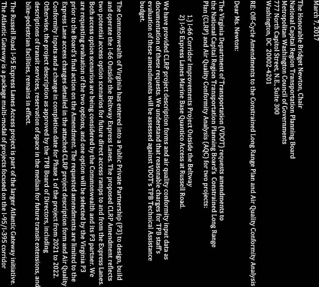
ITEM 15 Notice March 29, 2017
|
|
|
- Grant Ellis
- 5 years ago
- Views:
Transcription
1 ITEM 15 Notice March 29, 2017 Notice of Proposed Amendment to the 2016 Constrained Long Range Plan (CLRP), As Requested by the Virginia Department of Transportation (VDOT) and the Maryland Department of Transportation (MDOT) Staff Recommendation: Issues: Review proposed project submissions as an amendment to the 2016 CLRP None Background: As described in the attached materials, VDOT and MDOT have requested an amendment to the 2016 CLRP to update the I-66 outside the Beltway project, to add a new exit ramp from the northbound HOT lanes directly to Russell Rd in southern Prince William County, and to change the year of completion of the Governor Nice Bridge replacement in Charles County, MD from 2030 to 2023.
2
 approved the 2016 Constrained Long-Range Transportation Plan (CLRP) Amendment on November 16, 2016.")
3 MEMORANDUM TO: Transportation Planning Board FROM: Lyn Erickson, TPB Plan Coordination and Program Director SUBJECT: Proposed Amendment to the 2016 Constrained Long-Range Transportation Plan (CLRP) DATE: March 9, 2017 The Transportation Planning Board (TPB) approved the 2016 Constrained Long-Range Transportation Plan (CLRP) Amendment on November 16, The next scheduled update of the CLRP will occur in Since there is no scheduled update of the CLRP planned to occur before 2018, and the Virginia Department of Transportation (VDOT) and the Maryland Department of Transportation (MDOT) have projects that have progressed to a point where a CLRP update is needed in 2017, VDOT and MDOT have requested an amendment to the 2016 CLRP for three projects. The proposed changes are relatively minor, but will affect the Air Quality Conformity Analysis, and will therefore require a new demonstration of air quality conformity before they can be incorporated into the CLRP. This off-cycle conformity analysis is being requested so that the projects can remain on schedule. VDOT and MDOT will pay for this analysis out of their Technical Assistance portion of the 2017 Unified Planning Work Program. VDOT is proposing to construct an off-ramp from the northbound I-95 HOT lanes to serve the area near the Marine Corps Base Quantico in Prince William County. The new ramp would provide direct access from the northbound HOT lanes to Russell Road. More information can be found on this project on the CLRP project description form starting on page 5. VDOT is also proposing modifications to the I-66 outside the Beltway HOT lanes project in Fairfax and Loudoun Counties to reflect changes to the preferred alternative which was included in the 2016 CLRP. These proposed changes would modify the locations of various access points between the HOT lanes and general purpose lanes, as well as some other roadways. More information can be found on this project on the CLRP project description form starting on page 9. Maryland has recently approved funding to advance construction of the Governor Harry W. Nice Bridge Improvement Project. The Governor Harry W. Nice Bridge connects Charles County, Maryland to King George County, Virginia over the Potomac River, and this project will replace the existing 2- lane structure with a new 4-lane structure. This project is already included in the current 2016 Constrained Long Range Plan (CLRP). However, MDOT is proposing modifications to the construction timeline to reflect an earlier completion date of 2023 instead of More information can be found on this project on the CLRP project description form starting on page 23. OPPORTUNITY FOR PUBLIC COMMENT On March 9, 2017, the TPB released the projects and scope of work for a 30-day public comment period which will conclude at 11:59 P.M. on Saturday, April 8. Comments may be submitted: Online at Via at TPBcomment@mwcog.org METROPOLITAN WASHINGTON COUNCIL OF GOVERNMENTS 777 NORTH CAPITOL STREET NE, SUITE 300, WASHINGTON, DC MWCOG.ORG/TPB (202)
4 By calling (202) , TDD: (202) Or in writing to The Transportation Planning Board 777 North Capitol Street, NE, Suite 300 Washington, DC The TPB will be asked to approve the proposed amendment for inclusion in the Air Quality Conformity Analysis of the CLRP at the April 19 meeting. A second comment period will be held in September 2017 after the results of the Air Quality Conformity Analysis have been finalized. The TPB will be asked to approve the Air Quality Conformity Analysis and the CLRP amendment on October 18,


5 3

6 4


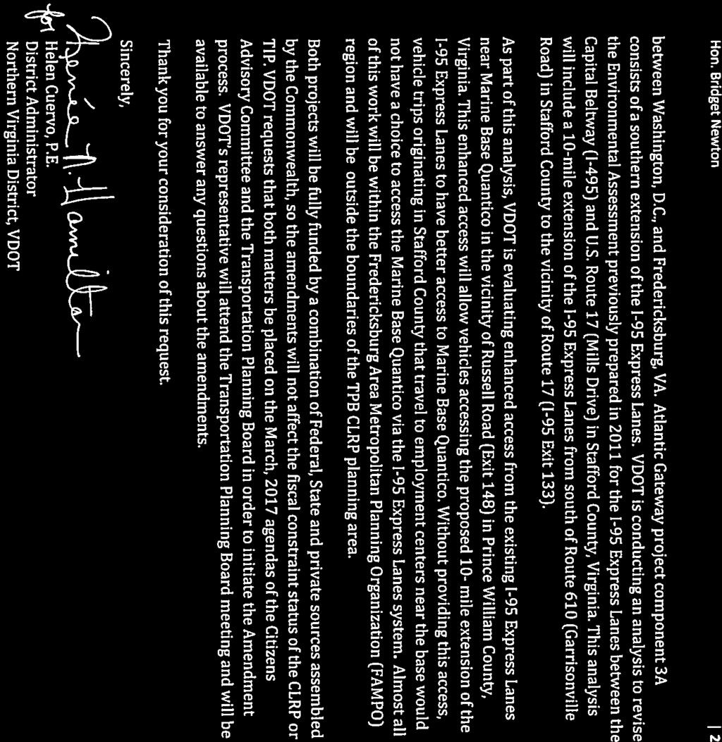
7 FINANCIALLY CONSTRAINED LONG-RANGE TRANSPORTATION PLAN FOR 2040 PROJECT DESCRIPTION FORM BASIC PROJECT INFORMATION 1. Submitting Agency: Virginia Department of Transportation 2. Secondary Agency: n/a 3. Agency Project ID: UPC Project Type: X Interstate Primary Secondary Urban Bridge Bike/Ped Transit CMAQ ITS Enhancement Other Federal Lands Highways Program Human Service Transportation Coordination TERMs 5. Category: X System Expansion; System Maintenance; X Operational Program; X Study; Other 6. Project Name: I-95 Express Lane Extension to Fredericksburg 7. Facility: Interstate From ( at): Exit 148: Russell Road (Prince Wm Co, VA) 9. To: 0.25 mile south of Exit 148 (Stafford Co, VA) 10. Description: Project components include: VDOT is conducting analysis to revise the Environmental Assessment previously prepared in 2011 for the I-95 Express Lanes between the Capital Beltway (I-495) and U.S. Route 17 (Mills Drive) in Stafford County, Virginia. This analysis will include a 10-mile extension of the I-95 Express Lanes from south of Route 610 (Garrisonville Road) in Stafford County to the vicinity of Route 17 (I-95 Exit 133). As part of this analysis, VDOT is evaluating enhanced access from the existing I-95 Express Lanes near Marine Base Quantico in the vicinity of Russell Road (Exit 148) in Prince William County, Virginia. This enhanced access will allow vehicles accessing the proposed 10- mile extension of the I-95 Express Lanes to have better access to Marine Base Quantico. Without providing this access, vehicle trips originating in Stafford County that travel to employment centers near the base would not have a choice to access the Marine Base Quantico via the I- 95 Express Lanes system. 11. Projected Completion Year: Project Manager: Amanda Baxter 13. Project Manager Amanda.Baxter@vdot.virginia.gov 14. Project Information URL: Total Miles: 0.25 mile (approximate) 5
: 16,500 cost estimate as of 02/01/2017 20. Amended Cost (in Thousands): N/A cost estimate as of MM/DD/YYYY 21.")
8 16. Schematic (file upload): CLRP PROJECT DESCRIPTION FORM 17. State/Local Project Standing (file upload): 18. Jurisdictions: Prince William and Stafford Counties, VA 19. Baseline Cost (in Thousands): 16,500 cost estimate as of 02/01/ Amended Cost (in Thousands): N/A cost estimate as of MM/DD/YYYY 21. Funding Sources: X Federal; X State; Local; X Private; Bonds; Other Regional Policy Framework: Questions address the goals identified in the Regional Transportation Priorities Plan. Question 28 should be used to provide additional context of how this project supports these goals or other regional needs identified in the Call for Projects. 22. Provide a Comprehensive Range of Transportation Options Please identify all travel mode options that this project provides, enhances, supports, or promotes. XSingle Driver XCarpool/HOV Metrorail Commuter Rail Streetcar/Light Rail BRT XExpress/Commuter bus Metrobus Local Bus Bicycling Walking Other X Does this project improve accessibility for historically transportation-disadvantaged individuals (i.e., persons with disabilities, low-incomes, and/or limited English proficiency?) 6
9 CLRP PROJECT DESCRIPTION FORM 23. Promote Regional Activity Centers X Does this project begin or end in an Activity Center? Does this project connect two or more Activity Centers? X Does this project promote non-auto travel within one or more Activity Centers? 24. Ensure System Maintenance, Preservation, and Safety X Does this project contribute to enhanced system maintenance, preservation, or safety? 25. Maximize Operational Effectiveness and Safety Project is primarily designed to reduce travel time on highways and/or transit without building new capacity (e.g., ITS, bus priority treatments, etc.)? X Does this project enhance safety for motorists, transit users, pedestrians, and/or bicyclists? 26. Protect and Enhance the Natural Environment X Is this project expected to contribute to reductions in emissions of criteria pollutants? X Is this project expected to contribute to reductions in emissions of greenhouse gases? 27. Support Interregional and International Travel and Commerce Please identify all freight carrier modes that this project enhances, supports, or promotes. Long Haul Truck Local Delivery Rail Air Please identify all passenger carrier modes that this project enhances, supports, or promotes. Air Amtrak intercity passenger rail Intercity bus 28. Additional Policy Framework Response Please provide additional written information that describes how this project further supports or advances these and other regional goals or needs. MAP-21 PLANNING FACTORS 29. Please identify any and all planning factors that are addressed by this project: a. X Support the economic vitality of the metropolitan area, especially by enabling global competitiveness, productivity, and efficiency. b. X Increase the safety of the transportation system for all motorized and non-motorized users. i. Is this project being proposed specifically to address a safety issue? Yes; X No ii. If yes, briefly describe (in quantifiable terms, where possible) the nature of the safety problem: c. X Increase the ability of the transportation system to support homeland security and to safeguard the personal security of all motorized and non-motorized users. d. X Increase accessibility and mobility of people. e. X Increase accessibility and mobility of freight. f. X Protect and enhance the environment, promote energy conservation, improve the quality of life, and promote consistency between transportation improvements and State and local planned growth and economic development patterns. g. X Enhance the integration and connectivity of the transportation system, across and between modes, for people and freight. h. X Promote efficient system management and operation. i. X Emphasize the preservation of the existing transportation system. 7
10 ENVIRONMENTAL MITIGATION CLRP PROJECT DESCRIPTION FORM 30. Have any potential mitigation activities been identified for this project? Yes; X No a. If yes, what types of mitigation activities have been identified? Air Quality; Floodplains; Socioeconomics; Geology, Soils and Groundwater; Vibrations; Energy; Noise; Surface Water; Hazardous and Contaminated Materials; Wetlands CONGESTION MANAGEMENT INFORMATION 31. Congested Conditions a. Do traffic congestion conditions necessitate the proposed project or program? X Yes; No b. If so, is the congestion recurring or non-recurring? X Recurring; Non-recurring c. If the congestion is on another facility, please identify it: I-95 Northbound General Purpose Lanes 32. Capacity a. Is this a capacity-increasing project on a limited access highway or other principal arterial? X Yes; No b. If the answer to Question 32.a was yes, are any of the following exemption criteria true about the project? (Choose one, or indicate that none of the exemption criteria apply): None of the exemption criteria apply to this project a Congestion Management Documentation Form is required The project will not use federal funds in any phase of development or construction (100% state, local, and/or private funding) X The number of lane-miles added to the highway system by the project totals less than one lane-mile X The project is an intersection reconstruction or other traffic engineering improvement, including replacement of an at-grade intersection with an interchange The project, such as a transit, bicycle or pedestrian facility, will not allow private single-occupant motor vehicles The project consists of preliminary studies or engineering only, and is not funded for construction The construction costs for the project are less than $10 million. c. If the project is not exempt and requires a Congestion Management Documentation Form, click here to open a blank Congestion Management Documentation Form. RECORD MANAGEMENT 33. Completed Year: 34. Project is being withdrawn from the CLRP. 35. Withdrawn Date: MM/DD/YYYY 36. Record Creator: 37. Created On: 38. Last Updated by: 39. Last Updated On: 40. Comments: 8


11 Technical Committee Item #7 FINANCIALLY CONSTRAINED LONG-RANGE TRANSPORTATION PLAN FOR 2040 PROJECT DESCRIPTION FORM BASIC PROJECT INFORMATION 1. Submitting Agency: Virginia Department of Transportation 2. Secondary Agency: Virginia Department of Rail & Public Transportation 3. Agency Project ID: A-297, P101 UPC#105500, UPC# Project Type: X Interstate Primary Secondary Urban Bridge Bike/Ped X Transit CMAQ X ITS Enhancement Other Federal Lands Highways Program Human Service Transportation Coordination TERMs 5. Category: X System Expansion; Study; Other System Maintenance; X Operational Program; 6. Project Name: I-66 Corridor Improvements Project Outside the Beltway Prefix Route Name Modifier 7. Facility: I From: US 15, Prince William County 9. To: I-495, Fairfax County 2/23/17 Page 1 9
12 10. Description: The Commonwealth s I-66 Corridor Improvements Project ( Project ) outside the Beltway was first submitted for the 2015 CLRP Air Quality Analysis, and a subsequent FY16 submission provided minor modifications to the project, based on the Commonwealth Transportation Board s (CTB s) selection of a Preferred Alternative on October 27, The adopted 2016 CLRP amendment that includes these modifications was approved by the TPB on November 16, The project CTB's Preferred Alternative in the most recently adopted CLRP includes the following elements: Three general purpose lanes in each direction between US 15 in Haymarket and I-495 / Capital Beltway (with auxiliary lanes between interchanges where needed: between US 29 Gainesville and VA 234 Bypass / Prince William Parkway; and between US 29 Centreville and I-495 / Capital Beltway); Two barrier-separated managed express lanes in each direction (the existing high-occupancy vehicle (HOV) lane will be converted to an express lane and one new express lane will be added); A phased approach to construction that includes express lanes from Gainesville to I-495 in the first phase (opening in 2022), with the remaining portion of the corridor express lanes between Gainesville and Haymarket constructed by In addition, a typical section that provides space in the median for future transit will be phased as well, between US 15 Haymarket and US 29 Centreville; New or expanded commuter park and ride lots in the corridor; New high-frequency bus service with more predictable travel times; and Direct access ramps to and from the Express Lanes. Under the P3 project development process, the Virginia Department of Transportation (the Department) has partnered with a P3 developer to design, construct, and operate the I-66 Express Lanes. Modifications for future direct access ramps to and from the Express Lanes, under two potential access option scenarios, are being considered by the P3 developer and the Department. Access Update Option A reflects the proposed access point configuration included in the P3 developer s technical proposal for the project. Access Update Option B includes the access points in Update A, plus potential additional access points that are under consideration by the P3 developer and the Department: Access Update Option A : o Haymarket - west of US 15 to / from east and west* o Gainesville - US 29 for Phase 1, the eastbound entrance from the General Purpose lanes to the I-66 Express lanes and the westbound exit from the I-66 Express lanes to the General Purpose lanes are located east of US 29 o Gainesville - at University Boulevard to / from east o VA 234 Bypass / Prince William Parkway to / from west* o Cushing Road Park and Ride Lot / VA 234 Bypass to / from east* o Manassas - Balls Ford Road Park and Ride Lot to / from east o East of Sudley Road - I-66 mainline transition ramps to allow (i) eastbound movement from General Purpose lanes to I-66 Express lanes 2/23/17 Page 2 10
13 and (ii) westbound movement from I-66 Express lanes to General Purpose lanes o Centreville VA 28 to / from east and west (access between west and south excluded) o Centreville I-66 mainline transition ramps to allow all movements between I-66 General Purpose lanes and I-66 Express lanes o Centreville Stringfellow Road to / from east o Fair Oaks Monument Drive to / from east and west o Fairfax US 50 to / from east (I-66) and northwest (US 50) o Fairfax VA 123 to / from east and west o Vienna Vaden Drive to / from west o Dunn Loring from Eastbound I-66 General Purpose lanes to Eastbound I- 66 Express lanes o I-495 interchange all movements towards the west of the I-495 interchange are provided: (i) from northbound I-495 General Purpose lanes and I-495 Express lanes to westbound I-66 Express lanes, (ii) from southbound I-495 General Purpose lanes and I-495 Express lanes to westbound I-66 Express lanes, (iii) from eastbound I-66 Express lanes to northbound I-495 General Purpose lanes and I-495 Express lanes and (iv) from eastbound I-66 Express lanes to southbound I-495 General Purpose lanes and I-495 Express lanes * implemented in ultimate phase of Preferred Alternative by 2040; all other access is part of Phase 1, constructed by Access Update Option B : Includes all access points in Access Update Option A plus: o VA 234 Bypass / Prince William Parkway to / from east o Centreville West of US29 I-66 mainline transition ramps to allow (i) eastbound movement from I-66 Express lanes to General Purpose lanes and (ii) westbound movement from General Purpose lanes to I-66 Express lanes o Fairfax VA 286 to west (I-66) from south (VA 286) o Fairfax US 50 to / from east (I-66) and southeast (US 50) o East of US 50 - I-66 mainline transition ramps to allow (i) eastbound movement from eastbound General Purpose lanes to I-66 Express lanes and (ii) westbound movement from I-66 Express lanes to General Purpose lanes o Nutley Street - to / from east and west shown under Update Option B implemented in Phase 1, by Below are two typical sections that will be implemented along the corridor. The first typical section illustrates the alternative selected by the Commonwealth Transportation Board for the Preferred Alternative. The second typical section illustrates the alternative that will be initially utilized as part of a phased construction approach, from east of US 29 Gainesville to US 29 Centreville only, under Phase 1. Once the entire project is constructed, the cross section will be reconfigured where needed to allow for future transit. 2/23/17 Page 3 11


14 Preferred Alternative Flexible Barrier with Buffer & Median reserved for Future Center Transit Phase 1 (Opening Year Configuration) Flexible Barrier with Buffer and No Median Between US 29 Gainesville and US 29 Centreville Access to the I-66 Express Lanes will be available to automobiles, motorcycles, emergency vehicles, buses and transit vehicles, and multi-axle vehicles. A high-level preliminary assessment of multi-axle vehicles in the I- 66 Express Lanes has been performed by VDOT 1. Heavy-trucks with two or more trailers will not be allowed to use the I-66 Express Lanes. Vehicles with three or more occupants and motorcycles would travel on the Express Lanes for free, as per the code of the Commonwealth of Virginia and Federal law. The facility will be operated and enforced for HOV3+ occupancy and toll payment in a manner that complies with the statutory requirements of the Commonwealth. Other vehicles not meeting the occupancy requirement of 1 VDOT White Paper Preliminary analysis of multi-axle vehicles in the I-66 Express lanes between Haymarket and the Beltway ; October 5, /23/17 Page 4 12
15 3+ will pay a toll, using electronic toll collection equipment, at a rate that will vary based on congestion, to ensure free-flow conditions as specified by Federal regulations. Multi-axle vehicle toll rates are required to be not less than five times the two-axle toll rate during peak periods and not less than three times the two-axle rate during all other times. Allowing HOV-3 s to ride free is consistent with this policy change, and will also match the High Occupancy Toll lane occupancy requirement on I-495 and I-95. The Project expands the NoVA network of Express lanes by connecting to the I-495 Express Lanes Project, which also connects to the newly constructed I-95 Express Lanes. The project includes a robust transit component, consisting of new and expanded commuter bus services providing one-seat rides between park and ride lots and major regional destinations on I-66 to complement Metrorail in the corridor. New and expanded park and ride lots are included throughout the corridor, with easy or direct access to the managed lanes. Finally, to promote and incentivize alternative modes in the corridor, new and enhanced corridor transportation demand management strategies will be included as part of the project. Bicycle and Pedestrian accommodations in the corridor are included as part of the Preferred Alternative, and will be consistent with VDOT s Policy for Integrating Bicycle and Pedestrian Accommodations ( Project construction, operations and maintenance will be procured using Virginia s Public-Private Transportation Act (PPTA) legislation leading to the selection of a private consortium ( P3 Developer ). A comprehensive agreement will ultimately outline all of the terms and conditions of the Public- Private Partnership. Tolling Policy Express lanes use dynamic pricing to maintain free-flowing conditions for all users, even during rush hour. The toll rates will vary throughout the day corresponding to demand and congestion levels. Toll prices will be adjusted in response to the level of traffic to ensure free flowing operations. Dynamic message signs will provide drivers with current toll rates so they can choose whether or not to use the lanes. Toll collection on the Express Lanes will be totally electronic. There will be no toll booths. The dynamic message signs will be supplemented by other notification/communications methods to ensure all users, including transit operators, have as much advance notice of traffic conditions as is possible. MAP-21 mandates strict performance standards which are intended to ensure free-flowing conditions on the Express lanes. The proposed Express lanes 2/23/17 Page 5 13
16 project will include performance monitoring as an integral part of the project and ensure that the MAP-21 mandated performance standards are complied with as a minimum. More specifically, the project will meet all applicable requirements of MAP-21 regarding HOV Facility Management, Operation, Monitoring, and Enforcement as described in Section 166 of Title 23 U.S.C., inclusive of the amendments (deletions, insertions and additions) prescribed by MAP-21 Section 1514 "HOV FACILITIES". This includes a minimum average operating speed of 45 mph for 90% of the time over a specific period of time during the peak period. The I-66 Express Lanes will have a posted speed limit of 70 mph. The general purpose lanes have posted speeds ranging from 55 mph 65 mph throughout the corridor. Schedule ion of the Phase 1 Project is projected to begin in in late The facility is expected to enter operations in The remaining elements of the Preferred Alternative will be implemented by Federal Environmental Review ( NEPA ) Process The completed Tier 2 Environmental Assessment for the Preferred Alternative built upon and included a combination of concepts identified in the Tier 1 Environmental Impact Statement. It evaluated site-specific conditions and potential effects the proposed improvements would have on air quality, noise, neighborhoods, parks, recreation areas, historic properties, wetlands and streams. The Tier 2 Final Environmental Assessment was approved on June 21, 2016, and FHWA issued a Finding of No Significant Impact on June 22, A reevaluation of the approved Environmental Assessment for the proposed project modifications, in compliance with Federal (NEPA) and state regulations, is planned to be completed in late Transportation Management Plan As a matter of policy, practice and a reflection the agency s commitment to safety, VDOT adopts Transportation Management Plans for its construction projects. Such Plans are also required by FHWA for large projects such as this initiative. The congestion mitigation plans used for projects such as the Springfield Interchange, the I-495 Express Lanes, and the I-95 Express Lanes have been very successful in managing traffic during construction. VDOT and the P3 Developer will similarly implement a robust Transportation Management Plan for this Project. Coordination with Other Projects in the Corridor This project is being coordinated with other active projects in the corridor such as: Vaden Drive ramp improvements (now incorporated into I-66 project) 2/23/17 Page 6 14
17 Route 28 / I-66 interchange improvements (now incorporated into I-66 project) US 15 / I-66 interchange improvements Financial Plan The total cost for the proposed Project is estimated to be approximately $2 3 billion in year of expenditure dollars. Funding sources for the Project will include a combination of private and public equity and third party debt, including private bank loans and/or Private Activity Bonds, with TIFIA funding as a form of subordinated debt. The P3 Developer will be fully authorized to toll the facility, which will serve to pay debt service, operating and maintenance costs, state police costs, transit costs, support for future corridor improvements and return on equity. Toll revenue will be the main source of revenue. The Commonwealth entered into a Comprehensive Agreement with the P3 Developer, authorizing the P3 Developer to raise the necessary funds to construct the Project, on December 8, Stakeholder Outreach A Stakeholder Technical Advisory Group (STAG) has been established and meets regularly. The STAG provides the opportunity for direct engagement with various groups along the corridor, including local jurisdictions, environmental resource agencies, transit service providers, and various other agencies. Stakeholder and public outreach is a high priority for the I-66 project team. A Transit/TDM Technical Advisory Group (TTAG) has been actively engaged in project development. There have been numerous opportunities for the public to learn more about the Project, as well as provide comments, through public meetings, the project website, and community dialogs in addition to other items. The project outreach has included 2 sets of Public Information Meetings and two sets of Public Hearings. VDOT has had over 300 meetings with various stakeholders so far and this will continue throughout the duration of the project. Public Information Meetings and a Design Public Hearing are planned in Projected Completion Year: 2022 for Phase 1 / 2040 for Preferred Alternative 12. Project Manager: Ms. Susan Shaw, P.E. 13. Project Manager susan.shaw@vdot.virginia.gov 14. Project Information URL: Total Miles: 23 miles for Phase 1 / 26 miles for Preferred Alternative 16. Schematic: See figures in items 9 and 10 above, as well as attached roll maps. 2/23/17 Page 7 15
18 17. Documentation: The graphics included in the response to items 9 and 10 above have been uploaded to allow a more readable version. All project documentation may be accessed electronically at: Jurisdictions: Fairfax County, Prince William County 19. Baseline Cost (in Thousands): $2,000,000 - $3,000,000 (approximately 2 to 3 $billion) combined public & private cost estimate as of 11/10/ Amended Cost (in Thousands): $2,400,000 (Phase 1) / approximately $3,100,000 (Preferred Alternatives) - combined public & private cost as of 2/23/ Funding Sources: X Federal; X State; X Local; X Private; X Bonds; Other Regional Policy Framework 22. Provide a Comprehensive Range of Transportation Options Please identify all travel mode options that this project provides, enhances, supports, or promotes. X Single Driver X Carpool/HOV X Metrorail X Commuter Rail Streetcar/Light Rail X BRT X Express/Commuter bus X Metrobus X Local Bus X Bicycling X Walking Other Does this project improve accessibility for historically transportation-disadvantaged individuals (i.e., persons with disabilities, low-incomes, and/or limited English proficiency?) X Yes No 23. Promote Dynamic Activity Centers Does this project begin or end in an Activity Center? X Yes No Does this project connect two or more Activity Centers? X Yes No Does this project promote non-auto travel within one or more Activity Centers? X Yes No 24. Ensure System Maintenance, Preservation, and Safety Does this project contribute to enhanced system maintenance, preservation, or safety? X Yes No 25. Maximize Operational Effectiveness and Safety Does this project reduce travel time on highways and/or transit without building new capacity (e.g., ITS, bus priority treatments, etc.)? Yes X No Does this project enhance safety for motorists, transit users, pedestrians, and/or bicyclists? X Yes No 26. Protect and Enhance the Natural Environment Is this project expected to contribute to reductions in emissions of criteria pollutants and/or greenhouse gases? X Yes No 27. Support Interregional and International Travel and Commerce Please identify all freight carrier modes that this project enhances, supports, or promotes. X Long-Haul Truck X Local Delivery Rail Air 2/23/17 Page 8 16
19 Please identify all passenger carrier modes that this project enhances, supports, or promotes. Air Amtrak intercity passenger rail X Intercity bus 28. Additional Policy Framework In the box below, please provide any additional information that describes how this project further supports or advances these and other regional goals. VDOT and DRPT s Transforming I-66 Outside the Beltway project addresses several RTPP goals, as noted above. The project will be particularly effective in helping the Region achieve RTPP Goal # 1: Provide a Comprehensive Range of Transportation Options. This innovative project will combine capacity improvements with managed lanes, congestion pricing, intelligent transportation systems, new transit services, ride-sharing, new and expanded park and ride lots and bicycle and pedestrian facilities improvements to expand the range of transportation alternatives available to travelers. Moreover, the project is being designed to reserve opportunities for future westward extension of Metrorail or other high quality transit services. The project addresses the four major problems cited in Goal Statement #1: roadway congestion, transit crowding, inadequate bus service, and unsafe walking and biking. The Preferred Alternative, as approved by the Commonwealth Transportation Board, is the culmination of a process that began with the development of the Draft Tier1 Environmental Impact Statement for I-66 Outside the Beltway. This document concluded that there was not a single mode solution to the problems associated with I-66. Adding enough freeway lanes to insure reliable travel was not feasible, while it was determined that the mix of modes, strategies and technologies embodied in what became the Preferred Alternative would provide improved and expanded travel opportunities. MAP-21 PLANNING FACTORS 29. Please identify any and all planning factors that are addressed by this project: a. X Support the economic vitality of the metropolitan area, especially by enabling global competitiveness, productivity, and efficiency. b. X Increase the safety of the transportation system for all motorized and non-motorized users. i. Is this project being proposed specifically to address a safety issue? Yes; X No ii. If yes, briefly describe (in quantifiable terms, where possible) the nature of the safety problem: c. X Increase the ability of the transportation system to support homeland security and to safeguard the personal security of all motorized and non-motorized users. d. X Increase accessibility and mobility of people. e. X Increase accessibility and mobility of freight. 2/23/17 Page 9 17
20 f. X Protect and enhance the environment, promote energy conservation, improve the quality of life, and promote consistency between transportation improvements and State and local planned growth and economic development patterns. g. X Enhance the integration and connectivity of the transportation system, across and between modes, for people and freight. h. X Promote efficient system management and operation. i. X Emphasize the preservation of the existing transportation system. ENVIRONMENTAL MITIGATION 30. Have any potential mitigation activities been identified for this project? X Yes; No a. If yes, what types of mitigation activities have been identified? Air Quality; X Floodplains; X Socioeconomics; X Geology, Soils and Groundwater; Vibrations; Energy; X Noise; Surface Water; X Hazardous and Contaminated Materials; X Wetlands CONGESTION MANAGEMENT INFORMATION 31. Congested Conditions a. Do traffic congestion conditions necessitate the proposed project or program? X Yes; No b. If so, is the congestion recurring or non-recurring? X Recurring; Non-recurring c. If the congestion is on another facility, please identify it: 32. Capacity a. Is this a capacity-increasing project on a limited access highway or other principal arterial? X Yes; No b. If the answer to Question 32.a was yes, are any of the following exemption criteria true about the project? (Choose one, or indicate that none of the exemption criteria apply): X None of the exemption criteria apply to this project a Congestion Management Documentation Form is required The project will not use federal funds in any phase of development or construction (100% state, local, and/or private funding) The number of lane-miles added to the highway system by the project totals less than one lanemile The project is an intersection reconstruction or other traffic engineering improvement, including replacement of an at-grade intersection with an interchange 2/23/17 Page 10 18
21 The project, such as a transit, bicycle or pedestrian facility, will not allow private single-occupant motor vehicles The project consists of preliminary studies or engineering only, and is not funded for construction The construction costs for the project are less than $10 million. c. If the project is not exempt and requires a Congestion Management Documentation Form, click here to open a blank Congestion Management Documentation Form. RECORD MANAGEMENT 33. Completed Year: 34. Project is being withdrawn from the CLRP. 35. Withdrawn Date: MM/DD/YYYY 36. Record Creator: 37. Created On: 38. Last Updated by: 39. Last Updated On: 40. Comments: 2/23/17 Page 11 19
22 20
23 21


24 22
25 BASIC PROJECT INFORMATION 1. Submitting Agency: Maryland Transportation Authority 2. Secondary Agency: 3. Agency Project ID: 4. Project Type: Interstate Primary Secondary Urban Bridge Bike/Ped Transit CMAQ ITS Enhancement Other Federal Lands Highways Program Human Service Transportation Coordination TERMs 5. Category: System Expansion; System Maintenance; Operational Program; Study; Other 6. Project Name: Governor Harry W. Nice Bridge Improvement Project 7. Facility: 8. From ( at): 9. To: Prefix Route Name Modifier 10. Description: a new four-lane bridge north of the existing bridge, with a barrier-separated, two-way bicycle/pedestrian path on the south side of the bridge. Included in the project is preventative maintenance of the existing bridge until the construction phase is programmed. 11. Projected Completion Year: Project Manager: Mr. Glen Smith 13. Project Manager gsmith2@mdta.state.md.us 14. Project Information URL: Total Miles: 16. Schematic (file upload): 17. State/Local Project Standing (file upload): 18. Jurisdictions: US 301 Bridge over the Potomac River US 301 Charles County, MD King George County, VA 19. Baseline Cost (in Thousands): $768,600 cost estimate as of MM/DD/YYYY 20. Amended Cost (in Thousands): cost estimate as of MM/DD/YYYY 21. Funding Sources: Federal; State; Local; Private; Bonds; Other Regional Policy Framework: Questions address the goals identified in the Regional Transportation Priorities Plan. Question 28 should be used to provide additional context of how this project supports these goals or other regional needs identified in the Call for Projects. 22. Provide a Comprehensive Range of Transportation Options Please identify all travel mode options that this project provides, enhances, supports, or promotes. Single Driver Carpool/HOV Metrorail Commuter Rail Streetcar/Light Rail BRT Express/Commuter bus Metrobus Local Bus Bicycling Walking Other Does this project improve accessibility for historically transportation-disadvantaged individuals (i.e., persons with disabilities, low-incomes, and/or limited English proficiency?) 23
26 23. Promote Regional Activity Centers Does this project begin or end in an Activity Center? Does this project connect two or more Activity Centers? Does this project promote non-auto travel within one or more Activity Centers? 24. Ensure System Maintenance, Preservation, and Safety Does this project contribute to enhanced system maintenance, preservation, or safety? 25. Maximize Operational Effectiveness and Safety Project is primarily designed to reduce travel time on highways and/or transit without building new capacity (e.g., ITS, bus priority treatments, etc.)? Does this project enhance safety for motorists, transit users, pedestrians, and/or bicyclists? 26. Protect and Enhance the Natural Environment Is this project expected to contribute to reductions in emissions of criteria pollutants? Is this project expected to contribute to reductions in emissions of greenhouse gases? 27. Support Interregional and International Travel and Commerce Please identify all freight carrier modes that this project enhances, supports, or promotes. Long-Haul Truck Local Delivery Rail Air Please identify all passenger carrier modes that this project enhances, supports, or promotes. Air Amtrak intercity passenger rail Intercity bus 28. Additional Policy Framework Response Please provide additional written information that describes how this project further supports or advances these and other regional goals or needs. MAP-21 PLANNING FACTORS 29. Please identify any and all planning factors that are addressed by this project: a. Support the economic vitality of the metropolitan area, especially by enabling global competitiveness, productivity, and efficiency. b. Increase the safety of the transportation system for all motorized and non-motorized users. i. Is this project being proposed specifically to address a safety issue? Yes; No ii. If yes, briefly describe (in quantifiable terms, where possible) the nature of the safety problem: c. Increase the ability of the transportation system to support homeland security and to safeguard the personal security of all motorized and non-motorized users. d. Increase accessibility and mobility of people. e. Increase accessibility and mobility of freight. f. Protect and enhance the environment, promote energy conservation, improve the quality of life, and promote consistency between transportation improvements and State and local planned growth and economic development patterns. g. Enhance the integration and connectivity of the transportation system, across and between modes, for people and freight. h. Promote efficient system management and operation. i. Emphasize the preservation of the existing transportation system. 24
27 ENVIRONMENTAL MITIGATION 30. Have any potential mitigation activities been identified for this project? Yes; No a. If yes, what types of mitigation activities have been identified? Air Quality; Floodplains; Socioeconomics; Geology, Soils and Groundwater; Vibrations; Energy; Noise; Surface Water; Hazardous and Contaminated Materials; Wetlands CONGESTION MANAGEMENT INFORMATION 31. Congested Conditions a. Do traffic congestion conditions necessitate the proposed project or program? Yes; No b. If so, is the congestion recurring or non-recurring? Recurring; Non-recurring c. If the congestion is on another facility, please identify it: 32. Capacity a. Is this a capacity-increasing project on a limited access highway or other principal arterial? Yes; No b. If the answer to Question 32.a was yes, are any of the following exemption criteria true about the project? (Choose one, or indicate that none of the exemption criteria apply): None of the exemption criteria apply to this project a Congestion Management Documentation Form is required The project will not use federal funds in any phase of development or construction (100% state, local, and/or private funding) The number of lane-miles added to the highway system by the project totals less than one lane-mile The project is an intersection reconstruction or other traffic engineering improvement, including replacement of an at-grade intersection with an interchange The project, such as a transit, bicycle or pedestrian facility, will not allow private single-occupant motor vehicles The project consists of preliminary studies or engineering only, and is not funded for construction The construction costs for the project are less than $10 million. c. If the project is not exempt and requires a Congestion Management Documentation Form, click here to open a blank Congestion Management Documentation Form. RECORD MANAGEMENT 33. Completed Year: 34. Project is being withdrawn from the CLRP. 35. Withdrawn Date: MM/DD/YYYY 36. Record Creator: P. Fleming 37. Created On: 1/4/ Last Updated by: Glen Smith 39. Last Updated On: 3/2/ Comments: 25
28 VDOT AND MDOT AMENDMENT TO THE 2016 CLRP AIR QUALITY CONFORMITY NETWORK INPUTS DRAFT 3/9/2017 ConID Project ID MARYLAND Agency ID Facility Lanes Improvement Facility From To Fr To Fr To Completion Date VDOT Preferred Alternative Access Update Option A or B MP18 US 301 Governor Nice Bridge Charles County, MD King George County, VA N/A VIRGINIA I 95 HOT lanes Ramp 0.25 miles south of Russell Rd. (Exit 148) Russell Road (Exit 148) N/A 718 VI1Y Widen / Revise Operations I 66 I 495 US In each direction: 3 general purpose + 1 Auxiliary In each direction: 3 general purpose + 2 express (multiaxle vehicles will + 1 HOV in peak direction during be allowed in peak period (during express lanes; off peak HOV lane is closed) speed limit of express lanes will be 70 mph) A & B 851 VI1Z Widen / Revise Operations I 66 US 50 US 29 Centreville 1 1 In each direction: 3 general purpose + 1 Auxiliary (2 Aux In each direction: per direction btwn VA 3 general purpose 286 & VA 28 only) + 1 HOV in peak + 2 express (multiaxle vehicles will direction during peak period (during off peak, HOV lane be allowed in is open to non express lanes; HOVs) speed limit of express lanes will be 70 mph) A & B 852 VI1ZA Widen / Revise Operations I 66 US 29 Centreville University Boulevard (new interchange for express lanes only) 1 1 In each direction: 3 general purpose In each direction: 3 general purpose + 2 express (multiaxle vehicles will + 1 HOV in peak direction during be allowed in peak period (during express lanes; off peak, HOV lane is open to non speed limit of HOVs) express lanes will be 70 mph) A & B 2016 CLRP Amendment Conformity Input Table xlsx 26 NOTE: Changes from the 2016 CLRP are shown in bold italics. Yellow shading represents both alternatives. Orange shading represents Alternative A only. Green shading represents Alternative B only.
29 VDOT AND MDOT AMENDMENT TO THE 2016 CLRP AIR QUALITY CONFORMITY NETWORK INPUTS DRAFT 3/9/2017 ConID Project ID Agency ID Facility Lanes Improvement Facility From To Fr To Fr To Completion Date VDOT Preferred Alternative Access Update Option A or B 853 VI1ZB Widen / Revise Operations I 66 University Boulevard (new interchange for express lanes only) US 15 (1.2 miles west of) 1 1 In each direction: 3 general purpose + 2 express (multiaxle vehicles will In each direction: 3 general purpose be allowed in + 1 HOV in peak express lanes; direction during peak period (during speed limit of off peak, HOV lane express lanes is open to non will be 70 mph) HOVs) (+1 Auxiliary each direction between US 29 and VA 234 Bypass only) 2040 A & B 752 I66R31 I66R32 I66R34 EB Expr to SB GP EB Expr to NB GP NB GP to WB Expr SB GP to WB Expr SB Expr to WB Expr I 495 Interchange (Capital Beltway GP and Express Lanes) A 753 I66R37 I 66 General Purpose Lanes Interchange Ramp NB Expr to WB GP (modification of existing loop ramp) I 495 Interchange (Capital Beltway GP and Express Lanes) A 754 Relocate / Reconstruct I 66 Interchange 755 Reconstruct I 66 Interchange Dual lane loop ramp from NB I 495 GP to I 66 WB GP relocated to dual lane flyover (existing ramp modified to NB I 495 GP to I 66 WB express; included in ConID 752) EB GP to SB GP WB GP to SB GP WB GP to SB Expr NB GP to EB GP SB GP to WB I I A 756 I66R29 I 66 flyover ramp EB general purpose to EB express lanes.5 mile east of VA A 752 I66R31 I66R32 I66R34 EB Expr to SB GP EB Expr to NB GP NB GP to WB Expr SB GP to WB Expr SB Expr to WB Expr I 495 Interchange (Capital Beltway GP and Express Lanes) B 753 I66R37 I 66 General Purpose Lanes Interchange Ramp NB Expr to WB GP (modification of existing loop ramp) I 495 Interchange (Capital Beltway GP and Express Lanes) B 2016 CLRP Amendment Conformity Input Table xlsx 27 NOTE: Changes from the 2016 CLRP are shown in bold italics. Yellow shading represents both alternatives. Orange shading represents Alternative A only. Green shading represents Alternative B only.
30 VDOT AND MDOT AMENDMENT TO THE 2016 CLRP AIR QUALITY CONFORMITY NETWORK INPUTS DRAFT 3/9/2017 ConID Project ID 754 Agency ID Facility Lanes Improvement Facility From To Fr To Fr To Relocate / Reconstruct I 66 Interchange 755 Reconstruct I 66 Interchange Dual lane loop ramp from NB I 495 GP to I 66 WB GP relocated to dual lane flyover (existing ramp modified to NB I 495 GP to I 66 WB express; included in ConID 752) EB GP to SB GP WB GP to SB GP WB GP to SB Expr NB GP to EB GP SB GP to WB GP Completion Date VDOT Preferred Alternative Access Update Option A or I I B 756 I66R29 I 66 flyover ramp EB general purpose to EB express lanes.5 mile east of VA B I 66 Interchange EB on ramp, WB off ramp to/from I 66 Express lanes EB off ramp, WB on ramp from/to I 66 Express lanes (in this alternative, the interchange would not be converted to a diverging diamond Nutley Street (VA 243) B 757 NRS Reconstruct I 66 Interchange Cloverleaf interchange converted to diverging diamond Nutley Street (VA 243) A 759 I66R27 I66R28 (duplicate project with ConID 399, above) EB off ramp, WB on ramp to/from I 66 Express lanes BUS /HOV 3/EXPRESS Vaden Drive / Vienna Metro Station 1 1 Bus / HOV 3 / express from proposed Express Lanes A I66R43 Remove I 66 ramp remove existing EB on ramp from Saintsbury Dr. at Vaden Dr A 759 I66R27 I66R28 (duplicate project with ConID 399, above) EB off ramp, WB on ramp to/from I 66 Express lanes BUS /HOV 3/EXPRESS Vaden Drive / Vienna Metro Station 1 1 Bus / HOV 3 / express from proposed Express Lanes B I66R43 Remove I 66 ramp remove existing EB on ramp from Saintsbury Dr. at Vaden Dr B 762 VI1YA Reconstruct I 66 Interchange Reconfigured interchange to eliminate C D roads & modify EB to NB loop ramp & WB to SB Chain Bridge Road (VA 123) A 763 I66R25 I66R26 EB on ramp, WB off ramp to/from I 66 Express lanes EB off ramp, WB on ramp from/to I 66 Express Chain Bridge Road (VA 123) A 2016 CLRP Amendment Conformity Input Table xlsx 28 NOTE: Changes from the 2016 CLRP are shown in bold italics. Yellow shading represents both alternatives. Orange shading represents Alternative A only. Green shading represents Alternative B only.
31 VDOT AND MDOT AMENDMENT TO THE 2016 CLRP AIR QUALITY CONFORMITY NETWORK INPUTS DRAFT 3/9/2017 ConID Project ID Agency ID Facility Lanes Improvement Facility From To Fr To Fr To Completion Date VDOT Preferred Alternative Access Update Option A or B 762 VI1YA Reconstruct I 66 Interchange Reconfigured interchange to eliminate C D roads & modify EB to NB loop ramp & WB to SB Chain Bridge Road (VA 123) B I66R25 I66R26 I66R23 I66R24 I66R23 I66R24 I 66 slip ramp I 66 slip ramp I 66 Express Lanes Interchange 766 NRS Reconstruct I 66 Interchange 766 NRS Reconstruct I 66 Interchange 768 I66R19 I66R20 I66R21 I66R22 Reconstruct / Revise Operations / I 66 Express Lanes Interchange EB on ramp, WB off ramp to/from I 66 Express lanes EB off ramp, WB on ramp from/to I 66 Express lanes EB general purpose lanes to EB express lanes WB express lanes to WB general purpose lanes EB express lanes on ramp from US50 NB; WB express lanes off ramp to SB US50 EB express lanes on ramp from SB US50; WB express lanes off ramp to NB US50 EB express lanes on ramp from SB US50; WB express lanes off ramp to NB US50 Reconfigure interchange to replace NWB to WB loop ramp with flyover Reconfigure interchange to replace NWB to WB loop ramp with flyover Existing reversible HOV ramp converted to express (EB onramp, WB off ramp to/from I 66 Express lanes); new EB off ramp, WB onramp from/to I 66 Express Chain Bridge Road (VA 123) B 0.5 mile east of US B 0.5 mile east of US US Lee Jackson Mem Highway (US Lee Jackson Mem Highway (US Lee Jackson Mem Highway (US Lee Jackson Mem Highway (US Monument Drive (US 50) A B A B 1 1 Bus / HOV 2 Reversible by time of day Bus / HOV 3 / express Movements in both directions 24 hrs/day A 768 I66R19 I66R20 I66R21 I66R22 Reconstruct / Revise Operations / I 66 Express Lanes Interchange Existing reversible HOV ramp converted to express (EB onramp, WB off ramp to/from I 66 Express lanes); new EB off ramp, WB onramp from/to I 66 Express Monument Drive (US 50) 1 1 Bus / HOV 2 Reversible by time of day Bus / HOV 3 / express Movements in both directions 24 hrs/day B 2016 CLRP Amendment Conformity Input Table xlsx 29 NOTE: Changes from the 2016 CLRP are shown in bold italics. Yellow shading represents both alternatives. Orange shading represents Alternative A only. Green shading represents Alternative B only.
Washington DC Section of ITE Project Briefing
 Washington DC Section of ITE Project Briefing November 5, 2015 Renée Hamilton, VDOT, Deputy District Administrator I-66 Outside the Beltway Improvement Area Project Location Virginia 2 Purpose and Need
I-66 Corridor Improvements Route 15 to I-495. November 2014
 I-66 Corridor Improvements Route 15 to I-495 November 2014 I-66 Corridor: Haymarket to the Beltway = Park and Ride Lots 2 Purpose and Need Improve multimodal mobility along the I-66 corridor by providing
EXHIBIT B-1 PROJECT DESCRIPTION. Phase 1 of the Preferred Alternative
 EXHIBIT B-1 PROJECT DESCRIPTION Phase 1 of the Preferred Alternative The Transform 66 Public-Private Partnership (P3) Project (the Project ) means the Phase 1 of the Preferred Alternative components of
DULLES AREA TRANSPORTATION ASSOCIATION (DATA) February 18, Susan Shaw, P.E., VDOT, Megaprojects Director
 February 18, Susan Shaw, P.E., VDOT, Megaprojects Director") DULLES AREA TRANSPORTATION ASSOCIATION (DATA) February 18, 2015 Susan Shaw, P.E., VDOT, Megaprojects Director I-66 Corridor Conditions Steady population growth Employment growth in activity centers Congestion
DULLES AREA TRANSPORTATION ASSOCIATION (DATA) February 18, 2015 Susan Shaw, P.E., VDOT, Megaprojects Director I-66 Corridor Conditions Steady population growth Employment growth in activity centers Congestion
I-395 Express Lanes Northern Extension Project Public Hearings
 I-395 Express Lanes Northern Extension Project Public Hearings Susan Shaw, PE, Megaprojects Director Virginia Department of Transportation Amanda Baxter, Special Projects Manager Virginia Department of
I-395 Express Lanes Northern Extension Project Fairlington Citizens Association September 12, 2016
 I-395 Express Lanes Northern Extension Project Fairlington Citizens Association September 12, 2016 Susan Shaw, PE, Megaprojects Director, Virginia Department of Transportation Amanda Baxter, Special Projects
I-395 Express Lanes Northern Extension Project Crystal City Civic Association September 21, 2016
 I-395 Express Lanes Northern Extension Project Crystal City Civic Association September 21, 2016 Mike Snare, PE, Project Manager Virginia Department of Transportation GEC Michelle Holland, Megaprojects
City of Fairfax, Virginia City Council Work Session
 City of Fairfax, Virginia City Council Work Session Agenda Item # 4c City Council Meeting 6/2/2015 TO: FROM: SUBJECT: Honorable Mayor and Members of City Council Robert Sisson, City Manager Discussion
Institute for Real Estate Management Chapter (IREM) 77 VDOT Northern Virginia Megaprojects September 13, 2017
 77 VDOT Northern Virginia Megaprojects September 13, 2017") Institute for Real Estate Management Chapter (IREM) 77 VDOT Northern Virginia Megaprojects September 13, 2017 Susan Shaw, P.E., Megaprojects Director Virginia Department of Transportation Northern Virginia
Institute for Real Estate Management Chapter (IREM) 77 VDOT Northern Virginia Megaprojects September 13, 2017 Susan Shaw, P.E., Megaprojects Director Virginia Department of Transportation Northern Virginia
Dulles Area Transportation Association. October 11, Susan Shaw, P.E., Megaprojects Director Virginia Department of Transportation
 Dulles Area Transportation Association October 11, 2017 Susan Shaw, P.E., Megaprojects Director Virginia Department of Transportation Transform 66: Outside the Beltway 2 Project Overview Multimodal improvements
Interstate 66 Tier 1 Environmental Impact Statement (EIS)
") WELCOME Welcome to the second Citizen Information Meeting for the Tier 1 Environmental Impact Statement (EIS). As an integral part in the environmental study process, the study team is seeking your comments
WELCOME Welcome to the second Citizen Information Meeting for the Tier 1 Environmental Impact Statement (EIS). As an integral part in the environmental study process, the study team is seeking your comments
Transform 66 Project February 4, 2016 Partnering Conference Michigan Department of Transportation American Council of Engineering Companies
 Transform 66 Project February 4, 2016 Partnering Conference Michigan Department of Transportation American Council of Engineering Companies Susan Shaw, PE, CCM, DBIA Megaprojects Director Northern Virginia
I-395 Express Lanes Northern Extension Project Arlington County Board October 18, 2016
 I-395 Express Lanes Northern Extension Project Arlington County Board October 18, 2016 Susan Shaw, PE, Megaprojects Director Virginia Department of Transportation Amanda Baxter, Special Projects Manager
Preliminary Transportation Analysis
 Preliminary Transportation Analysis Goals of a Robust, Multimodal Transportation Network Safe Accessible/Connected Efficient Comfortable Context-Sensitive Motor Vehicle: Continue to analyze the data to
County of Fairfax, Virginia. Department of Transportation
 Fairfax County Parkway History 2 Planning began 50 years ago 1960s Washington s Regional Transportation Plan Recommends improved north/south travel Construct Capital Beltway and outer beltway Outer beltway
PERFORMANCE ANALYSIS of The Draft 2015 CLRP
 Item 9 PERFORMANCE ANALYSIS of The Draft CLRP Presentation to the Transportation Planning Board September 16, CLRP Performance Analysis 1 What is the Long-Range Transportation Plan (CLRP)? The CLRP identifies
I-264 CORRIDOR EVALUATION STUDY. September 7, 2016 Eric Stringfield VDOT Planning Director Chris Lawrence AECOM Senior Transportation Engineer
 I-264 CORRIDOR EVALUATION STUDY September 7, 2016 Eric Stringfield VDOT Planning Director Chris Lawrence AECOM Senior Transportation Engineer Study Overview Interchange Locations Study Context Follow-up
Interstate 66 TRANSPORTATION TECHNICAL REPORT. From US Route 15 in Prince William County To Interstate 495 in Fairfax County FEBRUARY 2013
 FEBRUARY 2013 TRANSPORTATION TECHNICAL REPORT Interstate 66 From US Route 15 in Prince William County To Interstate 495 in Fairfax County Virginia Department of Rail and Public Transportation Transportation
Fairfax County Parkway Widening Fairfax County
 Get Involved VDOT representatives will review and evaluate information received as a result of this meeting. Please fill out the comment sheet provided in this brochure if you have any comments or questions.
Project Description Form 8EE
 Project Description Form 8EE Basic Project Information Submitting Jurisdiction/Agency: Town of Dumfries Project Title: Route 1 (Fraley Blvd) Widening: Brady's Hill Road to Dumfries Road Project Location:
Transform I-66. Chief Engineer Garrett W. Moore, P.E. July 12, 2018
 Transform I-66 Chief Engineer Garrett W. Moore, P.E. July 12, 2018 Transform 66: Program Goals Improve multimodal mobility by providing diverse travel choices in a cost-effective manner Enhance transportation
Highway 217 Corridor Study. Phase I Overview Report
 Highway 217 Corridor Study Phase I Overview Report November 3, 24 BACKGROUND AND OVERVIEW Study purpose The Highway 217 Corridor Study is developing multi-modal transportation solutions for traffic problems
Basalt Creek Transportation Refinement Plan Recommendations
 Basalt Creek Transportation Refinement Plan Recommendations Introduction The Basalt Creek transportation planning effort analyzed future transportation conditions and evaluated alternative strategies for
TRANSIT PERFORMANCE IN THE I-66 INSIDE THE BELTWAY CORRIDOR
 TRANSIT PERFORMANCE IN THE I-66 INSIDE THE BELTWAY CORRIDOR June 2018 This report summarizes the performance of public transportation systems serving the I-66 inside the Beltway corridor in Northern Virginia.
University Hill Transportation Study Technical Memorandum Alternatives Modeling and Analysis May 2007
 Technical Memorandum May 2007 Syracuse Metropolitan Transportation Council Edwards and Kelcey with Wallace Roberts and Todd Alta Planning and Design CONTENTS SECTION ONE- INTRODUCTION...1 SECTION TWO-
INTERSTATE 395 EXPRESS LANES NORTHERN EXTENSION ALTERNATIVES ANALYSIS TECHNICAL REPORT SEPTEMBER 2016
 INTERSTATE 395 EXPRESS LANES NORTHERN EXTENSION ALTERNATIVES ANALYSIS TECHNICAL REPORT SEPTEMBER 2016 INTERSTATE 395 EXPRESS LANES NORTHERN EXTENSION Alternatives Analysis Technical Report City of Alexandria,
NORTHERN VIRGINIA HIGHLIGHTS for the Dulles Area Transportation Association
 NORTHERN VIRGINIA HIGHLIGHTS for the Dulles Area Transportation Association June 20, 2012 Garrett Moore VDOT District Administrator, Northern Virginia Paving Program 2012 This season's paving program will
Sketch Level Assessment. of Traffic Issues. for the Fluor Daniel I-495 HOT Lane Proposal. Ronald F. Kirby
 Sketch Level Assessment of Traffic Issues for the Fluor Daniel I-495 HOT Lane Proposal Ronald F. Kirby Director of Transportation Planning National Capital Region Transportation Planning Board (TPB) Metropolitan
4. ENVIRONMENTAL IMPACT ANALYSIS 9. TRANSPORTATION AND TRAFFIC
 4. ENVIRONMENTAL IMPACT ANALYSIS 9. TRANSPORTATION AND TRAFFIC 4.9.1 INTRODUCTION The following section addresses the Proposed Project s impact on transportation and traffic based on the Traffic Study
Public Opinion about Transportation Issues in Northern Virginia
 Public Opinion about Transportation Issues in Northern Virginia Research and Strategy Presented to: The Northern Virginia Transportation Authority July 28, 2005 Research Objectives 1. Travel Patterns*
FY 2018 I-66 Commuter Choice Program Presentation to the Northern Virginia Transportation Commission May 3,
 FY 2018 I-66 Commuter Choice Program Presentation to the Northern Virginia Transportation Commission May 3, 2018 www.novatransit.o rg 703-524-3322 Presentation Overview I-66 Commuter Choice Program Overview
VDOT I-66 Inside the Beltway Eastbound Widening Environmental Assessment. Staff Recommendations
 VDOT I-66 Inside the Beltway Eastbound Widening Environmental Assessment Staff Recommendations Department of Environmental Services Transportation January 28, 2017 Timeline of Transform66 June 2012: I-66
Project Overview. Rolling Road Widening Fairfax County. Get Involved. Design Public Hearing. Contact Information
 Get Involved VDOT representatives will review and evaluate information received as a result of this meeting. Please fill out the comment sheet provided in this brochure if you have any comments or questions.
I-95 Express Lanes Fredericksburg Extension (Fred Ex) Public Hearing. September 25, 2017
 Public Hearing. September 25, 2017") I-95 Express Lanes Fredericksburg Extension (Fred Ex) Public Hearing September 25, 2017 Purpose of Tonight s Meeting Provide information and gain public input: Draft Environmental Assessment (EA) Design
I-95 Express Lanes Fredericksburg Extension (Fred Ex) Public Hearing September 25, 2017 Purpose of Tonight s Meeting Provide information and gain public input: Draft Environmental Assessment (EA) Design
Bicycle Master Plan Goals, Strategies, and Policies
 Bicycle Master Plan Goals, Strategies, and Policies Mobilizing 5 This chapter outlines the overarching goals, action statements, and action items Long Beach will take in order to achieve its vision of
Regional Transportation Needs Within Southeastern Wisconsin
 Regional Transportation Needs Within Southeastern Wisconsin #118274 May 24, 2006 1 Introduction The Southeastern Wisconsin Regional Planning Commission (SEWRPC) is the official areawide planning agency
Capital Beltway HOT Lanes - Frequently Asked Questions
 Capital Beltway HOT Lanes - Frequently Asked Questions December 20, 2007 1. What is the cost of the project? The fixed-price design-build cost is approximately $1.4 billion. 2. Why have the project costs
What if YOU could help plan Northern Virginia s transportation future?
 What if YOU could help plan Northern Virginia s transportation future? Photo credits: Washington Metropolitan Area Transit Authority And improve the quality of life in your community -- for yourself, your
Transportation Master Plan Advisory Task Force
 Transportation Master Plan Advisory Task Force Network Alternatives & Phasing Strategy February 2016 BACKGROUND Table of Contents BACKGROUND Purpose & Introduction 2 Linking the TMP to Key Council Approved
NOVEMBER 2017 DESIGN PUBLIC HEARINGS COMMENT SUMMARY (November 13, 14, and 16, 2017)
") NOVEMBER 2017 DESIGN PUBLIC HEARINGS COMMENT SUMMARY (November 13, 14, and 16, 2017) I-66 Outside the Beltway Project Between U.S. Route 29 in Gainesville and I-495/Capital Beltway in Fairfax County State
NOVEMBER 2017 DESIGN PUBLIC HEARINGS COMMENT SUMMARY (November 13, 14, and 16, 2017) I-66 Outside the Beltway Project Between U.S. Route 29 in Gainesville and I-495/Capital Beltway in Fairfax County State
Public Information Meeting
 Richmond Highway (U.S. Route 1) Corridor Improvements Public Information Meeting Tuesday, April 18, 2017 Mount Vernon High School 8515 Old Mt. Vernon Road, Alexandria, VA 22309 Amanda Baxter, VDOT, Special
2045 Long Range Transportation Plan. Summary of Draft
 2045 Long Range Transportation Plan Summary of Draft Fredericksburg Area Metropolitan Planning Organization The George Washington Region includes the City of Fredericksburg and the counties of Caroline,
AMATS Complete Streets Policy
 AMATS Complete Streets Policy Table of Contents: Section 1. Definition of Complete Streets Section 2. Principles of Complete Streets Section 3. Complete Streets Policy Section 4. Consistency Section 5.
495 EXPRESS LANES NORTHERN EXTENSION STUDY COMMENT SUMMARY REPORT JUNE 11, 2018 PUBLIC INFORMATION MEETING
 495 EXPRESS LANES NORTHERN EXTENSION STUDY COMMENT SUMMARY REPORT JUNE 11, 2018 PUBLIC INFORMATION MEETING Federal: NHPP-0495(095), State: 0495-029-419, UPC: 113414 The Virginia Department of Transportation
Project Description Form 6V
 Project Description Form 6V Basic Project Information Submitting Jurisdiction/Agency: Prince William County Project Title: Route 15 Widening: Route 55 to south of RR tracks & Construct RR Overpass Project
APPROVE A RESOLUTION ADOPTING A COMPLETE STREETS POLICY
 STAFF REPORT MEETING DATE: September 13, 2016 TO: FROM: City Council Bob Brown, Community Development Director Russ Thompson, Public Works Director Patrick Filipelli, Management Analyst 922 Machin Avenue
Santa Clara I-280 CORRIDOR STUDY
 Santa Clara I-280 CORRIDOR STUDY OCTOBER 2017 PREPARED BY: 1.1 Background The I-280 Corridor Study within Santa Clara County is a high-level highway planning study led by the Santa Clara VTA, in partnership
Exhibit 1 PLANNING COMMISSION AGENDA ITEM
 Exhibit 1 PLANNING COMMISSION AGENDA ITEM Project Name: Grand Junction Circulation Plan Grand Junction Complete Streets Policy Applicant: City of Grand Junction Representative: David Thornton Address:
FI-2 I-66 Between Route 29, Lee Highway and Route 15, James Madison Highway
 TRANSPORTATION PLAN INTENT Transportation is the key to the economic and social development of Prince William County and especially to the I 66/Route 29 Sector Plan area. This includes transportation for
DRAFT. Memo. Range of the Alternatives Considered in the EIS
 Memo Date: Friday, December 09, 2016 Project: To: From: Subject: State Route 30 EIS UDOT Vince Izzo This memorandum summarizes the draft State Route (S.R.) 30 Level 1 screening results. A more detailed
Route 29 Solutions Projects
 Route 29 Solutions Route 29 Solutions Projects www.route29solutions.org October 10, 2014 Route 29 Widening to Six Lanes Albemarle County This project will widen a 1.8-mile segment of Route 29 from four
5. RUNNINGWAY GUIDELINES
 5. RUNNINGWAY GUIDELINES These guidelines should be considered collectively when making runningway decisions. A runningway is the linear component of the transit system that forms the right-of-way reserved
BRIEFING ON PROPOSED ADDITIONS AND CHANGES Additions and Changes to Projects Proposed for Inclusion in the 2015 CLRP Update
 BRIEFING ON PROPOSED ADDITIONS AND CHANGES Additions and Changes to Projects Proposed for Inclusion in the 2015 CLRP Update January 23, 2015 Travel Forecasting Subcommittee What is the CLRP? Federally
TRASBURG RANSPORTATION
 TRASBURG RANSPORTATION LAN DEVELOPED BY THE TRANSPORTATION PLANNING DIVISION OF THE VIRGINIA DEPARTMENT OF TRANSPORTATION IN COOPERATION WITH THE U.S. DEPARTMENT OF TRANSPORTATION, FEDERAL HIGHWAY ADMINISTRATION
APPENDIX G: INTERSECTION NEEDS AT OKEECHOBEE BOULEVARD
 APPENDIX G: INTERSECTION NEEDS AT OKEECHOBEE BOULEVARD INTERSECTION NEEDS AT SR 7 and OKEECHOBEE BOULEVARD SR 7 Extension Project Development and Environment (PD&E) Study From Okeechobee Boulevard (SR
Commuter Connections Regional TDM Marketing Group Meeting
 Item #6 Commuter Connections Regional TDM Marketing Group Meeting September 19, 2017 Michelle T. Holland, Megaprojects Communications Manager Virginia Department of Transportation Program Area Map 2 Program
Los Altos Hills Town Council - June 18, 2015 Palo Alto City Council June 22, AGENDA ITEM #2.B Presentation
 Los Altos Hills Town Council - June 18, 2015 Palo Alto City Council June 22, 2015 AGENDA ITEM #2.B Presentation Previous Presentations Los Altos Hills Town Council in May 2014 and February 2015 Palo Alto
Circulation in Elk Grove includes: Motor vehicles, including cars and trucks
 Circulation, as it is used in this General Plan, refers to the many ways people and goods move from place to place in Elk Grove and the region. Circulation in Elk Grove includes: Motor vehicles, including
Highway 49, Highway 351 and Highway 91 Improvements Feasibility Study Craighead County
 Highway 49, Highway 351 and Highway 91 Improvements Feasibility Study Craighead County Executive Summary March 2015 Highway 49, Highway 351 and Highway 91 Improvements Feasibility Study Craighead County
I-105 Corridor Sustainability Study (CSS)
") I-105 Corridor Sustainability Study (CSS) Metro Streets and Freeways Subcommittee March 21, 2019 Gary Hamrick Cambridge Systematics, Inc. I-105 CSS Project History & Background Funded by Caltrans Sustainable
I-105 Corridor Sustainability Study (CSS) Metro Streets and Freeways Subcommittee March 21, 2019 Gary Hamrick Cambridge Systematics, Inc. I-105 CSS Project History & Background Funded by Caltrans Sustainable
PUBLIC COMMENT SUMMARY REPORT Public Information Meetings
 PUBLIC COMMENT SUMMARY REPORT 2015 Public Information Meetings I-66 Outside the Beltway Project Between U.S. Route 15 in Haymarket and I-495/Capital Beltway in Fairfax County State Project: 0066-96A-297,P101
North Coast Corridor:
 North Coast Corridor: Connecting People, Transportation & Environment Legislative Hearing: 11.8.10 1 North Coast Corridor Region s Lifeline A Regional Strategy Mobility, Economy & Environment North Coast
November 14, Dulles To DC Loop Public-Private Partnership Proposal. Executive Summary
 November 14, 2005 Dulles To DC Loop Public-Private Partnership Proposal Executive Summary Virginia Mobility Associates LLC, a newly established single purpose entity, proposes to privately finance the
Solana Beach Comprehensive Active Transportation Strategy (CATS)
") Solana Beach Comprehensive Active Transportation Strategy (CATS) 3.0 Goals & Policies The Solana Beach CATS goals and objectives outlined below were largely drawn from the Solana Beach Circulation Element
Solana Beach Comprehensive Active Transportation Strategy (CATS) 3.0 Goals & Policies The Solana Beach CATS goals and objectives outlined below were largely drawn from the Solana Beach Circulation Element
EXECUTIVE SUMMARY... vii 1 STUDY OVERVIEW Study Scope Study Area Study Objectives
 Contents EXECUTIVE SUMMARY... vii 1 STUDY OVERVIEW... 1-1 1.1 Study Scope... 1-1 1.2 Study Area... 1-1 1.3 Study Objectives... 1-3 2 EXISTING CONDITIONS... 2-1 2.1 Existing Freeway Conditions... 2-4 2.1.1
Proposed. City of Grand Junction Complete Streets Policy. Exhibit 10
 Proposed City of Grand Junction Complete Streets Policy Exhibit 10 1 City of Grand Junction Complete Streets Policy Vision: The Complete Streets Vision is to develop a safe, efficient, and reliable travel
Overview. Illinois Bike Summit IDOT Complete Streets Policy Presentation. What is a Complete Street? And why build them? And why build them?
 Overview Illinois Bike Summit IDOT Complete Streets Policy Presentation Aren Kriks, P.E. District One Bicycle Coordinator and Bureau of Programming Project Engineer History of Complete Streets IDOT Policy
Route 7 (East Market Street) Interchange at Battlefield Parkway Town of Leesburg Project No: UPC Presentation to Town Council
 Interchange at Battlefield Parkway Town of Leesburg Project No: UPC Presentation to Town Council") Route 7 (East Market Street) Interchange at Battlefield Parkway Town of Leesburg Project No: 0007-253-109 UPC 106573 Presentation to Town Council June 26, 2017 Council Decisions East Market Street / Battlefield
Route 7 (East Market Street) Interchange at Battlefield Parkway Town of Leesburg Project No: 0007-253-109 UPC 106573 Presentation to Town Council June 26, 2017 Council Decisions East Market Street / Battlefield
Portland International Airport Bicycle and Pedestrian Plan (October 2003) Staff Acknowledgements
 Staff Acknowledgements") Portland International Airport Bicycle and Pedestrian Plan (October 2003) Staff Acknowledgements Scott King, Senior Aviation Planner Jason Gately, Senior Aviation Planner Preston Beck, Associate Planner
Portland International Airport Bicycle and Pedestrian Plan (October 2003) Staff Acknowledgements Scott King, Senior Aviation Planner Jason Gately, Senior Aviation Planner Preston Beck, Associate Planner
City of Gainesville Transportation/Roadway Needs PROJECT SUMMARY
 A1 Roadway Resurfacing $23,846,000 TYPE: Preservation of existing system Roadway resurfacing A2 Signal Replacement $6,000,000 TYPE: Preservation of existing system Replace traffic signals. B1 W 6th St
Washington Metropolitan Area Transit Authority Board Action/Information Summary
 Washington Metropolitan Area Transit Authority Board Action/Information Summary Action Information MEAD Number: 200242 Resolution: Yes No TITLE: MWCOG Strategic Investment Plan & TPB Priorities PRESENTATION
3.0 PROJECT DESCRIPTION
 The following section of the Draft EIR contains a description of the proposed Elk Grove Boulevard/SR 99 Interchange Modification project, consistent with the requirements of CEQA Guidelines Section 15124.
MCTC 2018 RTP SCS and Madera County RIFP Multi-Modal Project Eval Criteria GV13.xlsx
 MCTC 8 RTP SCS and Madera County RIFP Multi-Modal Project Eval Criteria GV.xlsx Madera County Transportation Commission Regional Transportation Plan / Sustainable Communities Strategy Multi-Modal Project
Clackamas County Comprehensive Plan
 ROADWAYS The County s road system permits the movement of goods and people between communities and regions, using any of a variety of modes of travel. Roads provide access to virtually all property. They
Environment and Public Works Committee Presentation
 Mixed Use Centers Complete Streets Guidelines Project Environment and Public Works Committee Presentation December 10, 2008 Project Objectives: Conduct an inter-departmental and agency process to study
Memorandum. Fund Allocation Fund Programming Policy/Legislation Plan/Study Capital Project Oversight/Delivery Budget/Finance Contract/Agreement Other:
 Memorandum Date: November 20, 2017 To: Transportation Authority Board From: Eric Cordoba Deputy Director Capital Projects Subject: 12/5/17 Board Meeting: San Francisco Freeway Corridor Management Study
Arterial Management Plan for US Route 250 and State Route 623
 Arterial Management Plan for US Route 250 and State Route 623 June 25, 2014 Brad Shelton, AICP Access Management and Traffic Impact Analysis Programs Manager Transportation and Mobility Planning Division
Transportation Authority of Marin Renew Existing ½-cent Transportation Sales Tax
 Transportation Authority of Marin Renew Existing ½-cent Transportation Sales Tax Request for Approval of the Final Sales Tax Renewal Expenditure Plan Town of Tiburon June 20, 2018 Request Council to Approve
West Dimond Blvd Upgrade Jodhpur Street to Sand Lake Road
 West Dimond Blvd Jodhpur St to Sand Lake CSS Transportation Project Summary Municipality of Anchorage Project # 05 005 Project Manager: John Smith, P.E. (MOA PM&E) Project Administrator: Julie Makela,
Public Information and Participation Comments
 Two public meetings were held in December. The first meeting was December 6, 2011 at Mary Ellen Henderson Middle School and had 36 public attendees. The second meeting was on December 14, 2011 at the Arlington
Appendix D: Concept Screening
 Concept Description Concept #1 Route 288 Roadway Widening This concept consists of constructing a third lane on northbound and southbound Route 288 between Powhite Parkway and US 360. This improvement
Fairfax Alliance for Better Bicycling. Susan Shaw, P.E., Megaprojects Director Virginia Department of Transportation
 Fairfax Alliance for Better Bicycling February 28, 2019 Susan Shaw, P.E., Megaprojects Director Virginia Department of Transportation Nancy Smith, Public Relations Manager FAM Construction Chris Wells,
Perryville TOD and Greenway Plan
 Perryville TOD and Greenway Plan Greenway Glossary Pathway: A bicycle and pedestrian path separated from motorized vehicular traffic by an open space, barrier or curb. Multi-use paths may be within the
Congestion Reducing Activities. Toby Carr GDOT Director of Planning April 10, 2014
 Congestion Reducing Activities Toby Carr GDOT Director of Planning April 10, 2014 GDOT Performance Dashboard Congestion Congestion Relief Strategies 511 HEROS RTOP Highway Emergency Response Operators
Project Mobility - Route 3 South Express Toll Lanes. Industry Day Overview
 Project Mobility - Route 3 South Express Toll Lanes Industry Day Overview October 15, 2014 Today s Agenda Project Mobility Overview Design Alternatives and Construction Estimates Existing Traffic Congestion/Project
Northern Virginia Express Lanes Design Challenges and Solutions. IBTTA Maintenance and Roadway Operations Workshop June 25, 2018
 Northern Virginia Express Lanes Design Challenges and Solutions IBTTA Maintenance and Roadway Operations Workshop June 25, 2018 Virginia Express Lanes Overview 60 miles of managed lanes (4 projects) Long
Evaluation of Significant Transportation Projects in Northern Virginia Transportation District
 Evaluation of Significant Transportation s in Northern Virginia Transportation District Fact Sheet Spring 2014 Virginia Department of Transportation Study Update April 2014 Since the fall 2013 update,
Appendix F: Detailed Modeling Results
 Appendix F: Detailed Modeling Results TransAction Technical Report (This page intentionally left blank) METHODOLOGY FOR CALCULATION OF PERFORMANCE MEASURES F-3 (This page intentionally left blank) Approved
South King County High-Capacity Transit Corridor Study
 HIGH-CAPACITY TRANSIT CORRIDOR STUDY South King County Corridor South King County High-Capacity Transit Corridor Study Corridor Report August 2014 South King County High Capacity Transit Corridor Report
CITY OF BLOOMINGTON COMPLETE STREETS POLICY
 CITY OF BLOOMINGTON COMPLETE STREETS POLICY POLICY OBJECTIVE: The City of Bloomington will enhance safety, mobility, accessibility and convenience for transportation network users of all ages and abilities,
Corridor Advisory Group and Task Force Meeting #10. July 27, 2011
 Corridor Advisory Group and Task Force Meeting #10 July 27, 2011 1 Agenda Recap CAG/TF #9 Public Meeting #2 Summary Single Mode Alternatives Evaluation Results Next Steps 2 3 CAG/TF #9 Recap CAG /TF #9
Gordon Proctor Director Policy on Accommodating Bicycle and Pedestrian Travel on ODOT Owned or Maintained Facilities
 Approved: Policy: 20-004(P) Responsible Office: Planning Gordon Proctor Director Policy on Accommodating Bicycle and Pedestrian Travel on ODOT Owned or Maintained Facilities I. POLICY STATEMENT: This policy
City of Wayzata Comprehensive Plan 2030 Transportation Chapter: Appendix A
 A1. Functional Classification Table A-1 illustrates the Metropolitan Council s detailed criteria established for the functional classification of roadways within the Twin Cities Metropolitan Area. Table
INTRODUCTION. The focus of this study is to reduce congestion and improve mobility for all modes of transportation. Figure ES-1 Study Corridor Map
 INTRODUCTION The I-280 Corridor Study is a highway planning study led by Santa Clara VTA, in partnership with the City of Cupertino and in coordination with other stakeholders in the study area. The study
Public Hearing Tarrant County. October 11 th, 2012
 Public Hearing Tarrant County October 11 th, 2012 Public Hearing Agenda Welcome and Project Overview Ms. Maribel P. Chavez, P.E. District Engineer Texas Department of Transportation Fort Worth District
Gwinnett County Department of Transportation SR 324 / Gravel Springs Road at I-85 / SR 403 Interchange Project Number F , PI No.
 June 4, 2015 Dear Resident: Thank you for attending this public information meeting for the proposed SR 324 / Gravel Springs Road at I-85 Interchange. The purpose of this meeting is two-fold: to provide
Welcome. Thank you for your interest in the Lewis & Clark Viaduct Concept Study
 Welcome Thank you for your interest in the Lewis & Clark Viaduct Concept Study Please use the arrows in the upper left hand corner to navigate through the presentation. Use the envelope icon to ask a question
Mobility Greater Johnson County Transportation Coalition. May 23, 2018
 Mobility 2045 Greater Johnson County Transportation Coalition May 23, 2018 Agenda Regional Perspective Mobility Planning Overview Mobility 2045 Draft Recommendations Financial Planning Overview Schedule
DRAFT BUENA VISTA 2020 TRANSPORTATION PLAN
 DRAFT BUENA VISTA 2020 TRANSPORTATION PLAN DEVELOPED BY THE TRANSPORTATION PLANNING DIVISION OF THE VIRGINIA DEPARTMENT OF TRANSPORTATION IN COOPERATION WITH THE U.S. DEPARTMENT OF TRANSPORTATION, FEDERAL
ITEM 13 - Information March 19, Briefing on Final Report of the TPB Regional Value Pricing Study
 ITEM 13 - Information March 19, 2008 Briefing on Final Report of the TPB Regional Value Pricing Study Staff Recommendation: Receive briefing on the final report for the study, which was reviewed by the