Native Fish of the Upper Deschutes Status and Recommended Restoration Actions
|
|
|
- Leon McLaughlin
- 5 years ago
- Views:
Transcription


1 Native Fish of the Upper Deschutes Status and Recommended Restoration Actions Crooked River Deschutes River - Middle and Upper Reaches Metolius River

2 Native Fish of the Upper Deschutes: Status and Recommended Restoration Actions A Native Fish Society report. June 28, 2010 H. Tom Davis PE, Project Manager and Co-author Clair Kunkel, Fish Biologist and Co-author Russell Bassett, Production Manager For an electronic version of this report, please visit Introduction This report is intended for citizen advocates. The goal is to provide a concise summary of current issues and problems for native salmonids in the Upper Deschutes and describe the actions needed to resolve those problems. It is based on information from all federal and Oregon agencies involved in the upper Deschutes. Discussions were held with staff members from those agencies as needed to provide and interpret the hundreds of data sets, papers and reports pertinent to Upper Deschutes issues. Tom Davis, PE is the primary author of this report prepared for the Native Fish Society. Tom is a hydrologist and water resources engineer (MSCE University of Idaho) with emphasis on groundwater-surfacewater hydrology, water quality, nonpoint source controls, fish habitat impacts, wastewater, stormwater, erosion and floodplain analysis. Clair Kunkel (MS Fisheries, Oregon State University) was a contributing author and provided report sections regarding fish biology and habitat impacts. Clair is retired following a 31-year career as a biologist and manager with the Oregon Department of Fish and Wildlife (ODFW). Russell Bassett, NFS River Steward Coordinator, reviewed and formatted the report for printing. The regulatory process for managing fish and their habitats is very complex, and is not covered extensively in this document. Readers interested in more detail regarding this should contact the following: The Oregon Department of Fish and Wildlife (ODFW) manages fish in Oregon, but has little direct authority regarding watershed activities that damage fish habitat. The Oregon Department of Environmental Quality (ODEQ) implements state-federal water quality laws except as related to agriculture, logging/forest practices and land use. The Oregon Water Resources Department (OWRD) is responsible for administering Oregon water law. wrd.state.or.us/owrd/about_us.shtml Oregon Dept. of Land Conservation and Development (DLCD) - Oregon Department of Agriculture (ODA) - Oregon Department of Forestry (ODF) - Oregon Parks and Recreation Department (OPRD) - The Confederated Tribes of the Warm Springs Reservation (CTWS) - co-manages the Deschutes subbasin fisheries - Deschutes and Ochoco National Forests (USFS) - Us Bureau of Reclamation (USBR) - US Bureau of Land Management, Prineville (BLM) - US Fish & Wildlife Service, Oregon (USF&WS) - US National Marine Fisheries Service Northwest (NOAA) - The Crooked River Watershed Council, Deschutes Land Trust, Deschutes River Conservancy, and Upper Deschutes Watershed Council, restorethedeschutes.org/; are described in Appendix B. The related citizen groups are also described in Appendix B. 1
3 Table of Contents 1) Summary ) Relationships Between the Upper and Lower Deschutes ) Actions ) Oregon s Poor Protection and Restoration of Habitat The Bull Trout Critical Habitat Example ) Description - Upper Deschutes Basin Metolius Subbasin Upper Deschutes Subbasin Crooked Subbasin ) Native Fish of the Upper Deschutes Bull Trout Redband Trout Mountain Whitefish Other Native Resident Fish Summer Steelhead Spring Chinook Salmon Sockeye/Kokanee Salmon Pacific Lamprey Anadromous Fish Issues Introduced Salmonids Other Non-native Fish ) Surfacewater Groundwater Fish Passage and Connectivity Surfacewater and Groundwater Relationships Oregon Groundwater Mitigation Program Groundwater Pollution and the Impacts on Surface Water Flow and Habitat Issues ) Invasive/Nuisance Species ) Instream and Watershed Improvement Measures Needed Water Quality Riparian Zone Forest Management Agriculture Erosion Existing and Potential Enforceable Requirements ) Land Uses, Practices, Development and Planning/Control Erosion Controls Destination Resorts Legal County Plans and Protections City Plans and Protections Economic evaluation of fish and streams/lakes ) Stream Corridor Protection and Restoration Appendix A References presented separately from the main report and available by request from the Native Fish Society. Appendix B - Related Citizen Groups and Non-Governmental Organizations presented separately from the main report and available by request from the Native Fish Society 2
4 3
5 1 Summary The Upper Deschutes was once among the most productive salmonid fisheries in the western U.S. Dams, irrigation diversions, fish passage barriers, extreme high and low flows, bank and riparian damage, water quality deterioration, grazing, roads, soil disturbance during construction, invasive and nuisance species, wastewater systems, logging, wildfires, wildfire fighting, and erosion and sedimentation of spawning-rearing gravel have created one of our most damaged salmonid fisheries. The Upper Deschutes can be restored through projects and actions by citizen groups, nongovernmental organizations, private businesses and federal, state, tribal, and local agencies. This report summarizes the issues and problems, and the restoration and protection actions needed. More can be found in Appendix A - References. The current and planned cost for restoration is at least $300 million for 1) fish passage at Pelton-Round Butte dam complex for reintroducing anadromous salmonids 2) flow and habitat restoration by DRC, CRWC and UDWC; 3) removal of the smaller passage barriers; and 4) planning-monitoring. The cost could come close to doubling when the major passage facilities at Bowman, Ochoco, Wickiup and Crane Prairie Dams, and the habitat and conservation/flow projects associated with USBR projects and public lands are added. 2 Relationship Between the Upper and Lower Deschutes The entire watershed must be considered when examining its pieces. Any piece that is damaged or missing impacts the entire system, including the biological as well as the physical components. The watersheds of the Upper Deschutes subbasin and how they are managed heavily influence the condition of the lower Deschutes River and its fish resources. The water quality and quantity of the lower river is the sum of the groundwater, surface water and water system impacts in the upper subbasin. It is important to recognize the relationship between the upper and lower subbasins. The native fish populations of the Deschutes River have been blocked and fragmented by the dams since the mid 1960s, but may soon be reconnected as a result of a fish passage project at Pelton-Round Butte currently being implemented by Portland General Electric (PGE), the Confederated Tribes of the Warm Springs Reservation (CTWSR), and many partners in this landmark undertaking. If successful, this project will allow native salmon, steelhead, and lamprey back into some of their remaining historical habitat, and may reconnect fragmented populations of bull and redband trout and other native fish species. The return of anadromous fish into historical habitat will also add impetus for correcting a myriad of habitat issues in the Upper Deschutes subbasin. While correction of these issues is already critical for protecting resident redband, bull trout, and whitefish in the upper subbasin, the return of anadromous fish brings into play a new set of political, social, cultural, and regulatory considerations. The flow and temperature patterns of the lower river are largely regulated by release from the Pelton Round Butte dams and the condition and total volume of the released water is heavily dependent on the land use practices in the watersheds of the upper Deschutes. The lower Deschutes River has been designated as a federal and state Scenic Waterway, which provides a strong legal foundation for protection of water resources in the upper subbasin. A 1988 State Supreme Court decision (Diack vs. City of Portland) requires OWRD to determine that scenic waterway flows will not be impaired before issuing any new water rights. The OWRD recognized that consumptive use of groundwater in the upper Deschutes watershed diminishes flows in the lower Deschutes. New rules were adopted in 2002 (OAR ) to allow for limited additional groundwater development while mitigating for the effects of groundwater withdrawals on surface water flows. Many reaches of the Upper Deschutes subbasin require substantial changes in surface and groundwater management to meet the flow and temperature needs of native fish. 4
6 3 Actions Numerous actions to significantly improve native fisheries of the Upper Deschutes are described in this chapter. The relevant background and justifications for the actions are throughout the report. In total, the actions provide an engagement strategy for native fish advocates and related citizen groups. A wide range of issues is addressed, so priorities for the actions are not provided. Each reader and organization should prioritize the actions according to their interests and what actions they can be the most effective on. Special Protection The following special protections are needed: Accelerated funding is needed for ESA, economic and job-related habitat projects by Oregon, federal and local governments. Designating the stream corridors as described in this report that are critical habitat for the reintroduced anadromous steelhead and Chinook salmon as Areas of Critical Statewide Concern (ACSC) under the 1973 Oregon Land Use Planning Law (SB-100) will help accomplish this. Citizen groups must become more aware of the economic and cultural values of aquatic ecosystem protection and recovery, and then communicate with related interests to discuss the programs and projects needed and the implications. These include agricultural, forest products, land development, tourism, recreation, political, business/economic interests and resource agencies. Flow and Instream Habitat Restoration Flow and instream habitat restoration are needed as follows and as discussed in this report: 300 to 400 cfs minimum flows and reduction of peak flow releases below Wickiup Dam. Studies by the Deschutes Water Alliance indicate that, through water conservation and improved reservoir operation protocols, these flow improvements can be met without affecting irrigation use. Wickiup to Bend stream improvements involving bank stabilization; channel, bank and riparian habitat restoration; and flow release protocols that flush sediments from the spawning-rearing substrate and restore and maintain a more natural, fluvial geomorphologic structure. Allocation of storage space in Prineville Reservoir to provide flows below Bowman Dam as follows: For redbands, depending on season: Spawning = 200 to 250 cfs +/- Fry = 80 to 90 cfs +/- Juvenile = 140 to 160 cfs +/- Adult = 250 to 350 cfs For steelhead & Chinook, season dependent and released at water temperatures and river mile locations that preclude temperature barriers to passage/migration: Steelhead spawning = 140 to 160 cfs Steelhead juvenile = 160 to 180 cfs Chinook spawning = 180 to 200 cfs Chinook juvenile = 130 to 140 cfs 50 to 70 cfs minimum flow in Whychus Creek, depending on season. Designation by the U. S. Fish and Wildlife Service (USF&WS) of the Upper Deschutes mainstem and tributaries as Critical Habitat (CH) for bull trout. Restoration of riparian zones, stream corridors and natural, fluvial-geomorphologic structure. 5
7 Fish Passage and Screening Fish passage restoration and screening are needed as summarized below and discussed in this report: Restoration of passage for bull trout at Wickiup and Crane Prairie dams. Restoration of passage for steelhead at Opal Springs, Ochoco and Bowman dams. Application of methodologies for prioritizing passage and screening needs throughout the Upper Deschutes. Such prioritization methods should optimize the amount of habitat restored, the number and type of salmonids protected, benefits versus cost and risk of implementation problems. To the degree institutionally feasible the higher rated projects should be implemented early. Restoration of all the needed passage and installation of screening facilities at diversions and culverts; and enforcement of water rights and point of diversion in the Metolius subbasin within 4 years. Implementation by priority of all the needed passage and screening facilities in the Deschutes and Little Deschutes Rivers, Whychus and Tumalo Creeks, and all tributaries, within 10 years. Implementation of all the needed fish passage and screening facilities within 10 years in the Crooked River at/ below Ochoco and Bowman dams, and within 15 years above Ochoco and Bowman dams. Oregon Groundwater Mitigation Program The groundwater mitigation program implemented by OWRD is not working well for Upper Deschutes streams and salmonids. It will sunset in If it s renewed it should be amended to allow no additional groundwater use except for aquatic habitat improvement. The amendments that are essential are: Mitigation must not substitute warmer surfacewater for cooler groundwater, as addressed in a recent challenge regarding the proposed Thornburgh resort and discussed in interagency work sessions. Mitigation must be in the stream reach potentially affected. Mitigation must match the "timing" of the impact in the stream reach potentially affected. To ensure effectiveness and provide a safety factor, two acre-feet of mitigation water must be provided for each acre-foot of groundwater withdrawn from the groundwater flow systems. Groundwater Pollution and the Impacts on Surface Water The groundwater-surfacewater relationships in the Metolius, Whychus, upper and middle Deschutes; and Crooked River subbasins are complex. In the westside subbasins, most of the precipitation infiltrates and recharges groundwater, which feeds surfacewater. Under natural conditions this maintained relatively constant streamflows. Storage dams and irrigation diversions have severely altered that pattern. In the eastside subbasins much of the precipitation produces surface runoff and high streamflows in the spring. Under natural conditions wide meander plains with lush vegetation attenuated these high flows. The following actions are needed and discussed in this report: The changes to the Oregon Groundwater Mitigation Program listed above are essential. In areas where underground injection of stormwater, wastewater or industrial process water occurs or is proposed, the permits should not be approved or renewed by ODEQ until a groundwater-surfacewater flow and risk evaluation funded by the applicant(s) and managed by ODEQ is completed and the cumulative, long-term risk to water systems is found to be insignificant. The groundwater-surfacewater impacts of discharging stormwater into swales or other treatment facilities in the highly pervious westside subbasins should not be permitted by ODEQ until a detailed groundwater-surfacewater flow and risk evaluation funded by the applicant and managed by ODEQ is completed and the cumulative, longterm risk to water systems is found to be insignificant. An Areawide Waste Treatment Management Plan as described in δ 208 of PL (the Clean Water Act), should be funded by EPA for the LaPine area regarding regional solutions for the groundwater-surfacewater problems, followed by implementation grants. 6
8 Invasive/Nuisance Species Numerous invasive species that inhabit or impact aquatic ecosystems are in Oregon now, or are expected soon. It is a priority of federal and state agencies to counter these threats by preventative and remedial actions. These efforts need help from volunteers and individuals, particularly from those who work or recreate outdoors. Contact the local ODFW, USFS or BLM offices to learn about the programs in your area. Water Quality Water quality and the sources of pollution in the Upper Deschutes vary from subbasin to subbasin and in the level of complexity. The predominant water quality violation is for temperature and the causes are usually some combination of low flow because of irrigation diversions and degraded, or removal of, riparian vegetation. Erosion that causes turbidity and/or bedload movement is also a serious habitat problem. Pollution control has been slow because of delays in the modeling component of ODEQ s Total Maximum Daily Loads (TMDL) program. ODEQ has started a Watershed Assessment and Action Plan (WAAP) process to accelerate water quality awareness and improvements. The following actions are needed and discussed in Chapter 9: Wetlands and riparian areas throughout the Upper Deschutes must be protected and restored. County and city stormwater management plans that are effective for reducing nonpoint pollution loadings are needed throughout the area. Strong erosion control programs, ordinances and management criteria are essential. Water quality is generally excellent throughout the year in the Metolius but eutrophication and other problems occasionally emerge. It isn t clear what all the sources are and determining the sources should be a priority for ODEQ in cooperation with DLCD, followed by the necessary remedial actions. Whychus Creek and its tributary Indian Ford Creek have very serious water quality problems related to stream temperature, flow and habitat modifications. Flow below the Three Creeks Irrigation District diversion must be 50 to 70 cfs to prepare for steelhead and restore habitat for redbands. The Deschutes River above Bend has flow and flow-fluctuation problems that cause or contribute to habitat and water quality problems involving dissolved oxygen, chlorophyll-a, biochemical oxygen demand, ph, sedimentation, turbidity and bedload movement. The river flows must be restored to as near the natural 700 to 900 cfs as possible, and definitely above 300 cfs below Wickiup. Bank restoration projects to protect against erosion and provide fish habitat will be needed. These problems, causes and solutions should be high priorities in the ODEQ WAPP. Many of the lakes/creeks in the Upper Deschutes are on ODEQ s 303d list. In some cases the cause-effect relationships are uncertain. Blue-green algae is emerging as a serious problem in some lakes. The Little Deschutes River and some tributaries have water quality problems related to stream temperature. The groundwater is affected by nitrate that can cause drinking water problems. The nitrate is moving toward the Little Deschutes where it is likely to exacerbate stream eutrophication problems since the River is nitrogen limited. East and Paulina Lakes are of concern for mercury and Paulina for arsenic. The phosphorous, mercury and arsenic may be natural, but the nitrate is caused by onsite wastewater treatment systems. Solutions must be determined and implemented. According to DEQ the water quality in the Middle Deschutes River at Lower Bridge more closely resembles conditions in the Upper Crooked subbasin than conditions in the Upper Deschutes subbasin. Numerous causative factors exist and solutions must be implemented. The Upper Crooked River has experienced temperature, eutrophication, BOD, ph, total phosphate, total solids, ammonia, turbidity and sedimentation problems. Most originate with extremely low flows and habitat modifications, particularly riparian removal/degradation. The SB 1010 plans are sound, will mitigate many of the problems and must be implemented through mandatory Conservation Plans. 7
9 The Lower Crooked Subbasin water quality is influenced by logging, grazing, irrigated and nonirrigated agriculture, livestock feeding operations, recreation, urban non-point source pollution, and seasonal sewage treatment plant (STP) operations. The operation of Bowman and Ochoco dams cause low and fluctuating flow regimes that cause or exacerbate some of the problems, including Total Dissolved Gas (TDG). Solutions to these problems must be determined and implemented by the USBR, Ochoco Irrigation District, City of Prineville, Crook County and property owners (SB 1010 plans). Riparian Zone Assessments by the Crooked River and Upper Deschutes Watershed Councils, and the USFS and SB 1010 plans discuss the serious problems caused by damage to the riparian zone. Riparian information is in some city/county documents. Damage to stream geomorphologic structure must be addressed as a high priority. The following actions are needed and discussed in Chapter 9: A methodology is needed for prioritizing riparian restoration and protection, and restoration of stream geomorphologic structure. Such prioritization methods should optimize the amount of habitat restored, the number and type of salmonids affected, benefits versus cost, and ease of implementation. The degraded riparian zones on private lands must be prioritized for restoration and funding assistance by the three counties, ODEQ and ODA. EPA funds through δ 319 of PL may be available. Dedicated federal/state/local funds and 50% grants would accelerate riparian and stream corridor restoration and protection on private lands in the three counties. Federal, state and local agencies must prioritize and implement riparian projects. Forest Management The actions recommended below are described and expanded on in Chapter 9: Implement fish and wildlife habitat restoration projects such as the Metolius Wood Project. On all projects provide no disturbance stream corridors for floodplains, riparian areas and wetlands. On a site-specific basis apply the Glaze Forest riparian methods for projects that must include riparian tree removal to reduce wildfire risk and improve stream-vegetation conditions in the riparian area. Implement effective erosion controls as itemized in Chapter 9. Develop erosion reduction and sediment delivery criteria for tillers, which can be used for restoring soil productivity after equipment use for fire fighting, tree removal/thinning and decommissioning roads. Reduce road density on forestlands to one mile or less per square mile. Construct no additional roads. Minimize the length and width of all access trails/roads for thinning, biofuels and logging projects. Restore all such access trails to natural conditions immediately after completion of the project. Fish and wildlife habitat protection and restoration must be the highest priority goals. Limit recreation use and access to levels that are sustainable over the long-term without impacts to the fish, forest and wildlife resources. Limit ATV use to maintained roads that can be used by all vehicles. Impose high fines for violations. Agriculture The numerous management practices needed to reduce the impacts of agriculture on aquatic habitat are described in previous sections of this Chapter and Chapter 9. The ODA Agriculture Water Quality Area Management Plans are summarized in Chapter 9 and involve soil erosion and sediment control, nutrient and farm chemical management, streamside area management, irrigation management, livestock management, channel and drain management, and waste management. Some of the most important are: Restoration and protection of the riparian zones.* Passage installation at passage barriers.* Restoration and protection of the meander plains, stream corridors and geomorphologic structure.* 8
 provide shade, 2) trap or filter out excess nutrients, bacteria, and sediment in overland or shallow subsurface flow, 3) provide vegetative cover to protect the streambank")
10 Stabilize streambanks, preferably with bioengineering techniques. Encourage plants that 1) provide shade, 2) trap or filter out excess nutrients, bacteria, and sediment in overland or shallow subsurface flow, 3) provide vegetative cover to protect the streambank during high flows, and 4) have root masses that will stabilize streambanks. Leave large woody debris (LWD) in streams. If it must be removed, don t destabilize the streambank. Time the removal of LWD to minimize disturbance to stream and streambank. Use conservation tillage: reduced tillage, direct seeding, subsoiling, and chemical fallow. Farm on the contour: strip cropping, divided slopes, terraces, contour tillage. Select crops that hold soil in place and enhance a crop rotation. Encourage vegetation that provides good ground cover and enhances water capture. Practices include: prescribed burning, range plantings, juniper control, weed control. Use sediment retention basins. Roads: close seasonally; properly maintain, design, and place. Manage grazing: livestock distribution; grazing intensity, duration, frequency, and season. Install fencing: temporary, cross, exclosure. Control livestock watering through spring developments and off-stream water. Provide salt, minerals, and shade away from streams. Install adequate waste management systems: clean water diversions; waste collection, storage, and utilization; properly operate and maintain facilities. Select, locate, maintain, and operate diversions to minimize effects on water quality; install fish screens. Develop nutrient budgets based on water and soil testing, tissue testing, plant needs. Apply appropriate amounts at proper times; dispose of containers properly. Potential spills: have clean-up plan; store tanks away from streams, check the valves on delivery trucks. Use Integrated Pest Management. Stabilize banks (structural and bioengineering). Install outfall protection to reduce erosion at culverts. Develop wetlands at end of line to filter and process drain water. Size ditches appropriately to handle maximum flows. *This action is compatible with the SB 1010 plans but is not taken directly from the plans. The others are. The SB 1010 reports for the upper Deschutes are very well presented and generally recommend beneficial actions. The approach emphasizes voluntary compliance. A major need is for some of the actions listed in the plans to be required. The restoration and protection of riparian areas and stream geomorphology are important examples. One approach would involve requiring each farm to implement Conservation Plans, which are now voluntary and described in the reports. Such requirements could maintain flexibility depending on the land, water and farming practices involved at each farm. Financial incentives through a dedicated federal-state-local fund for riparian and stream corridor restoration grants would help. Erosion The erosion controls needed are described in Chapter 10, Land Use, and the Forest Management and Agriculture sections of Chapter 9. A few of the most important concepts are: Limit the soil area that can be exposed and vary the limits according to soil erodibility and slope. Prohibit soil disturbance/exposure in periods/seasons when greater erosion or sediment transport risk exists and prohibit leaving disturbed soils exposed during those periods. 9
11 A specific time limit, in a measurable number of weeks, on the exposure of disturbed soils, with no carryover from one year s season of soil disturbance/exposure to the next. A slope limit for soil disturbance/exposure that would be specific for the soils present and range in the Upper Deschutes from 15% to 30%, with no disturbance/exposure on slopes above 30%. Revegetate and stabilize soils between soil disturbance/exposure periods. Install temporary or permanent sediment catchments below disturbed soils. Erosion and sedimentation controls during construction that include immediate revegetation and mulching on slopes steeper than five (5) percent. Land Uses, Practices, Development and Planning/Control The land development actions recommended for Crook, Deschutes and Jefferson Counties; and the cities of Bend, LaPine, Madras, Prineville, Redmond and Sisters are described in Chapter 10. The actions include: Develop local-specific maps of erosion and sediment delivery risk, wetlands and riparian areas. Adopt and implement effective erosion control ordinances. The hydrologic analysis of the 100-year flood flows must include the upstream Urban Growth Areas with maximum density, impervious surface and the highest level of potential development assumed. Direct all residential, commercial and industrial development, including resorts, into Urban Growth Boundaries and existing urban areas. Repeal destination resort eligible lands maps and all county provisions for approving destination resorts outside Urban Growth Areas and existing urban areas. Adopt stormwater management plans and ordinances that are effective for reducing to insignificant the water quality impacts of stormwater runoff. The COIC draft plan is a good starting point. Provide effective treatment of all stormwater before discharge into groundwater or surface water. Adopt enforceable requirements that prohibit all new structural developments, soil disturbances and riparianwetland alterations in the stream corridors. Water quality and aquatic life protection, and floodplain function should be provided through minimum, no-disturbance stream corridors of: 1. For the main Deschutes, Metolius and Crooked Rivers, the 100-year floodplain plus the riparian area, adjoining wetlands and a 20 foot buffer; or 120 feet on both stream-sides from the 5-year floodplain, whichever is larger; 2. For major tributaries such as the Little Deschutes River and Ochoco, Whychus, Tumalo and McKay Creeks as examples, the 100-year floodplain plus the riparian area, adjoining wetlands and a 10 foot buffer; or 100 feet on both stream sides from the 5-year floodplain whichever is larger; feet on both sides of the stream from the 5-year floodplain for all perennial waterways; and feet on both sides of the stream from the thalwag of all intermittent and ephemeral waterways and channels since they are likely to transport pollutants and sediment. The DLCD/LCDC must implement the Metolius Area of Critical Statewide Concern to effectively preclude water quality/quantity and aquatic habitat impacts to the Metolius tributaries and mainstem, groundwater quality/quantity impacts and impacts to elk and deer critical range areas. 4 Oregon s Poor Protection and Restoration of Habitat Oregon s native fish and their habitats are inadequately protected. Some of the laws are strong, but implementation and enforcement is weak. The primary causes are political intimidation, timid public agencies that often depend on those they regulate for funding, and insufficient political backbone. The result is: a) pollutants discharged from nonpoint pollution sources including septic tanks and urban runoff, b) soil erosion at construction or other disturbance sites, c) erosion from logging roads and skid trails, d) delivery of sediment that damages spawning and alevin habitat, e) agricultural practices that damages habitat, f) aquatic and riparian habitat disturbance, g) dams with no fish passage/screening, h) inadequate instream flows and i) species needing but not getting restoration or special protection. 10
12 ODEQ, OWRD, ODA, ODF, and ODFW administer the state programs. DLCD has oversight of land use laws. Implementation is by cities, counties and special districts and is insufficient for protection of aquatic life. Some of the problems were brought to the surface by letters from ODFW, ODEQ and OWRD to Governor Kulongoski regarding Oregon s program insufficiency for protecting the world-class Metolius River from destination resorts; and a Dec. 14, 2005 letter from the U.S. Environmental Protection Agency (EPA) to ODFW on the Coastal Coho Plan (CCP). The Dec. 14, 2005 EPA letter summarizes the insufficiencies for Oregon s water quality programs. It targeted the CCP but applies statewide. continued implementation of the existing regulatory framework in Oregon does not adequately address widespread water quality problems and will not meet the goals in the CCP. there is a significant body of science demonstrating that regulatory programs in Oregon do not adequately protect water quality and associated beneficial uses (e.g., salmonid spawning and rearing, public water supply). The EPA letter also summarizes the inadequacies of Oregon s forest practice rules: there is a substantial body of science demonstrating that Oregon s existing forest practice rules and best management practices do not consistently meet water quality standards or fully provide riparian functions important to water quality, public water supplies and fish. Expert reviews and research have identified the need for increased protection of riparian management areas and landslide prone slopes in Oregon for both fish and non-fish streams to provide functions important for fish and water quality. additional revisions to the rules are needed to ensure water quality standards will be met and that beneficial uses such as salmonid spawning and rearing will be fully protected. A few quotes from ODFW s letter to the Governor about the Metolius follow: Even with the best mitigation actions there will be loss of fish and wildlife habitat through habitat fragmentation, incremental reductions in stream flow, increased human interaction, road development, etc. There have been a number of problems with implementation of mitigation requirements for destination resorts. These issues include lack of follow through by developers to implement agreed-upon mitigation actions; lack of county oversight to ensure agreed-upon mitigation measures are implemented;... The result has been a net loss of fish and wildlife habitat from all destination resorts in the state. ODEQ s Nov. 2, 2007 letter to the Governor about the Metolius stated the following: Subsurface discharge to shallow soils or land application to the surface of soils may be allowed. Even with substantial removal of nutrients and other constituents from this wastewater prior to discharge, small amounts of nutrients may reach the Metolius River or its tributaries through runoff or seepage to groundwater that flows into the Metolius. The river is sensitive to nutrients, and small increases in nutrients could result in some degradation of water quality, such as decreased dissolved oxygen, increased aquatic plant growth, and changes in ph, among others. ODEQ also made this accurate and candid statement: there are significant sources of pollutants that are comparatively uncontrolled, and the potential effects of these discharges, along with potential decreases in instream flow from development could have a measurable impact on an outstanding water such as the Metolius River. Regarding construction and land disturbances ODEQ states that its permits require practices and control technologies but that these do not always result in complete control. For post construction the letter continues, In general, DEQ does not have a regulatory framework for controlling stormwater from these developments once they are constructed. Local governments may exercise control. 11


13 OWRD s top priorities for water and water rights appear to be economic development and more municipal and agricultural water use. Numerous changes to state and federal implementation of fish, flow, water quality and land use laws, and possibly to the laws themselves, are essential. The statements from EPA, ODEQ, ODFG, OWRD and recent newspaper articles make this clear. Good will, weak regulations and voluntary efforts have failed to protect fish for decades. Enforceable requirements are essential. Such changes take time and native fish should not continue to assume the risk during the interim period. New land disturbances and water uses that may negatively impact aquatic resources should be put on hold until changes are made that adequately protect fish and aquatic habitat. ODFW, in concert with ODEQ, should be given authority to stop proposals that have such potential. As it stands, ODFW is left holding the bag for fish and wildlife losses that are caused by numerous federal, Oregon, local and private activities ODFW has no control over. OWRD requirements should be changed to always protect fish. The Bull Trout Critical Habitat Example A current example of the inadequate protection and restoration of salmonid habitat in the Upper Deschutes (UD) is the failure of the USF&WS in early 2010 to propose designation of the Upper Deschutes and tributaries above Big Falls as Critical Habitat (CH) for bull trout under the Endangered Species Act (ESA). Irrigation diversions, extremely low flows, passage barriers such as Wickiup and Crane Prairie Dams and channel degradation have extirpated bull trout above Big Falls according to fish biologists. Lack of foraging habitat in the mainstems and lack of access to spawning areas in the tributaries are key factors. Wickiup, owned by the Department of Interior (DOI), and the associated irrigation systems extirpated Bull trout. The USF&WS, also a DOI agency, stated that in Oregon 15% of the rivers and streams proposed for bull trout critical habitat status is unoccupied. This means that 15% of the 3,655-stream/river miles proposed for designation in Oregon as CH for bull trout recovery are unoccupied by bull trout. 50% of the lakes and reservoirs proposed for designation are also unoccupied. Current bull trout occupation wasn t a consistently applied criterion, but it was cited as a reason to eliminate the UD waters from CH designation. The USF&WS staff stated in public meetings that they wanted to avoid community resistance, but acknowledged that they had no credible survey of public opinion. The agency assumed resistance and political friction would occur if they included the UD. Non-native brook and brown trout are competitors with native redband in the UD, and may compete with reintroduced bull trout. Degraded habitat may favor non-native trout. Under improved habitat conditions, the competitive advantage should tilt more in favor of native redband and bull trout so a CH designation will also help native redband recovery. For example redband and bull trout perform well in the excellent habitat afforded by the Metolius system, despite the presence of brook and brown trout. 12
14 The USF&WS examined costs, but produced little evaluation of benefits. Based on extrapolating the annual $20 to $30 million economic benefits of a four-mile tailwater fishery below a USBR dam in New Mexico, the 55 miles of restored UD from Wickiup to Bend could be worth at least $50 to $100 million annually. A Habitat Conservation Plan (HCP) by those engaged in harmful/take activities is one of the ESA recovery options. One is underway in the UD by the irrigation districts but it is essentially closed to most fish groups. A CH designation would ensure a more open HCP process and be a catalyst for action and project funding. In addition to CH designation a credible USFWS feasibility study for the re-introduction of bull trout into the Upper Deschutes is essential. The study committee should include representation from relevant managing agencies, NGOs and citizen groups. The results must provide credible guidance for recovery actions needed to restore bull trout in the Upper Deschutes, including new USBR water conservation and passage facilities. The legal and scientific facts support designation of CH for the Upper Deschutes system above Big Falls. Much of the system was proposed for CH by the USF&WS in 2002, but not The designations will open doors for job and economic benefits through USBR remedial projects and involvement by more than just the irrigation community. The 2010 USF&WS CH proposal precludes most opportunities for major bull trout and redband improvements in the Upper Deschutes, which was naturally a fish Nirvana with spring fed flows ranging from 700 to 900 cfs. This element of the bull trout habitat ecosystem must be restored. 5 Description - Upper Deschutes Basin Following are brief descriptions of the three major subbasins that make up the upper Deschutes River basin, upstream from Round Butte Dam that creates Lake Billy Chinook (LBC). The three subbasins are the Metolius, upper Deschutes, and Crooked River. More detailed discussions of key habitat issues and native fish species are presented elsewhere in this summary. Metolius Subbasin The Metolius drains approximately 315 square miles, from 10,497 ft. on Mt. Jefferson, to 1,940 ft. at LBC. Land ownership is about 68% National Forest, 27% Warm Springs Reservation, and 5% private. The Metolius River arises from springs near Black Butte, and then flows 29 miles to LBC, which inundates the lower 12 miles of the historic river channel. Major tributaries include Lake, Jack, Canyon, Candle, and Jefferson creeks, and Whitewater River. Blue and Suttle lakes in the Lake Creek subbasin are natural, but with low-head dams. Fish passage is provided at Blue Lake and is planned at Suttle Lake. Major geologic features include the Cascade Mountains, Black Butte, Green Ridge, and the steep-walled canyon of the lower river. Precipitation is from inches per year, primarily in the form of snow. Most of the precipitation enters a complex groundwater system that flows through porous volcanic material and is the primary source of clear water flow in the river and tributaries. It provides very stable flows of up to 1400 cfs near LBC, with relatively constant temperatures between 40 F-55 F. The Metolius subbasin lies in a transitional zone between the Cascade Mountains and the high desert plateau of central Oregon. This is an extreme environment, with air temperatures ranging from -30 F in winter to over 90 F in summer. Vegetative features at higher elevations include wet meadows surrounded by alder, willow, and grasses, and forests of fir, cedar, and pine. Lower elevations feature steep canyons lined with juniper and sage. Riparian vegetation is very complex, especially around headwater springs, and in the steep canyons it is confined to a relatively narrow zone. The stable nature of the Metolius system provides outstanding habitat for native fish, including redband and bull trout, mountain whitefish; and a number of lesser-known non-game fish. Historic runs of spring Chinook, sockeye salmon, and Pacific lamprey utilized the Metolius system as well before the Pelton/Round Butte Dam complex ( ) extirpated them from the basin. A project is currently being implemented to provide passage at Pelton-Round Butte dams and re-establish anadromous fish runs. Summer steelhead probably utilized the Metolius system as well, but no historic documentation is evident. 13
15 Aquatic habitat conditions in the Metolius system are relatively good compared to most other streams in the Upper Deschutes. There are several fish passage issues and unscreened diversions on Lake Creek. Much of the large woody structure has been removed from the Metolius and some tributaries, which depletes cover and hydraulic refuge for fish. A major threat has been land developments including destination resorts and high-density subdivisions that would cause additional groundwater consumption, pollution, and upland and riparian disturbances detrimental to existing habitat quality. The main Metolius subbasin was declared an Area of Critical Statewide Concern (ACSC) in 2009 to protect the natural resources of the area. Most of the Metolius River has been designated as a federal, Oregon and Tribal Wild and Scenic River corridor. Upper Deschutes Subbasin The Upper Deschutes subbasin drains a watershed of approximately 2,200 square miles. Elevations range from 10,358 feet to 1,940 feet. Several reaches within the Upper Deschutes subbasin were designated as National Wild and Scenic Rivers in 1988, including: Big Marsh Creek from the confluence with Crescent Creek upstream 15 miles Little Deschutes River from source through upper canyon, 12 miles Deschutes River Wickiup Dam to Bend, Odin Falls to LBC Whychus Creek from source to intake at McAllister Ditch 15.4 miles Arising from headwaters at Little Lava Lake, the Deschutes River flows into Crane Prairie Reservoir, then into Wickiup Reservoir. Major tributaries above Crane Prairie include Snow, Cultus, and Deer creeks, and Cultus and Quinn rivers. Davis and Brown s creeks are tributaries to Wickiup Reservoir. The river reach from Wickiup Dam to the North Canal Dam at Bend is generally referred to as the upper Deschutes River. Major tributaries to the upper Deschutes include the Little Deschutes, Fall, and Spring rivers. The reach from Bend to LBC is generally referred to as the middle Deschutes River and the primary tributaries to the middle Deschutes are Tumalo and Whychus creeks. The Deschutes River from the headwaters to LBC is approximately 130 miles. From LBC, the Deschutes River flows another 100 miles to the Columbia River, and this lower reach is not included in this report. Air temperatures range between 15 F and 90 F, with extremes from -30 F to 100 F. Annual precipitation at higher elevations in the Cascade and Paulina mountains can be as high as 100 inches during wet years, but averages 9-14 inches per year throughout most of the subbasin. Most precipitation occurs as snow, and enters a complex groundwater system that is the source of flow in most tributaries. In its natural, spring-fed condition, the Deschutes River had very stable flows. Today, about 8 miles of the Deschutes River between the headwaters and Crane Prairie still feature natural flows. Flows in the entire 244 miles of river downstream from that point are regulated by dams, and subject to numerous water withdrawals. The effects are presented elsewhere in this report. Riparian systems consist primarily of willow, alder, and sedges. Margins of springs and groundwater-fed tributaries feature rich, complex riparian communities. The riparian zone is relatively narrow where the river and tributaries run through steep canyons. Riparian condition along most of the upper Deschutes are generally better, except for reaches impacted by development or livestock grazing. Several waterfalls exist and some of which are natural barriers to fish passage. In the early-mid 1900s, fish ladders were constructed on Steelhead Falls, Big Falls, and Cline Falls in attempts to provide anadromous fish passage beyond the historic natural limits. These fish ladders are currently considered not functional. 14

16 The upper Deschutes features over 400 natural lakes. Most of these lakes are fed by melting glaciers and snow, and are connected to lower elevation river and tributaries through groundwater flow. Few of these lakes had natural populations of fish, but 90 lakes are now stocked with trout and support recreational fisheries. Bull trout are endemic to Odell Lake, but were isolated from river populations by volcanic flows. A small population of bull trout still inhabits Odell Lake. Bull trout historically utilized Crescent and Davis lakes, but were extirpated from the upper Deschutes subbasin above Steelhead Falls by dams and artificial flow regimes. Native resident and anadromous fish are discussed in a separate chapter. The most severe habitat limitations in the upper Deschutes subbasin are caused by reservoirs, numerous dams, water withdrawals, unscreened diversions, and extreme artificial flow fluctuations due to the irrigation storage, release and withdrawal regime. Poor riparian conditions, erosion, sedimentation, and wide, shallow channel configurations result from artificial flow management. Reservoirs are heat sinks. During the irrigation season water temperatures in major reaches of the middle Deschutes, Whychus, Tumalo, Paulina, and Crescent creeks exceed the tolerance limits of salmonids. Out-of-stream water rights are over-appropriated in some reaches, most notably in Tumalo and Whychus creeks. When irrigation projects were developed, no provisions were made to protect instream flows for aquatic habitat. Prior to 1983, the only established minimum flow was 20 cfs below Wickiup Dam, which is a small fraction of the 700 to 900 cfs natural spring-fed flow. Instream water rights exist for the Deschutes River from Wickiup Dam to the North Canal Dam, but these rights are junior and rarely met during the critical, nonirrigation, winter period. Barriers at numerous storage, hydroelectric and irrigation diversion dams fragment fish populations. These are discussed in Chapter 7. Thousands of fish are drawn into canals through unscreened diversions and lost each season. Over 20 miles of once-productive stream habitats are now inundated by reservoirs. Much of the system lacks instream structure, particularly large woody debris. Large wood was removed to facilitate log drives and navigation, and to protect dams and diversion structures. Historic log drives from the upper river down to the old Bend sawmill pond severely abraded the river channel. Whychus Creek exhibits a different flow character than most other tributaries to the upper Deschutes. The upper reaches primarily contain runoff from melting snow in the spring. Low flows and high water temperatures occur during summer because of irrigation withdrawals and lack of shade-providing riparian cover. Habitat in lower Whychus Creek is improved by substantial groundwater inflows at Alder Springs. Residential and commercial development expanded rapidly from the 1970s to the present. Much of the additional water consumption is based on the spreading of older agricultural water rights, rather than establishment of new rights, thus many recent out-of-stream uses remain senior to the instream water rights. Increased groundwater use and its mitigation with warmer surface water impacts the quantity, quality and location of water feeding the streams. Habitat impacts from developments include clearing of riparian areas, stormwater runoff, septic tanks, reduced recruitment of woody structure, bank erosion, and construction of retaining walls and boat docks. 15

17 Crooked River Subbasin The Crooked River is the eastern-most tributary to the Upper Deschutes River, draining a watershed of 4,300 square miles, and flowing approximately 155 miles from its headwaters to LBC where it joins the Deschutes and Metolius rivers. Major geological features include the Ochoco and Maury mountains, rolling hills, high desert plateaus, steep canyons, and mid-elevation river valleys. The highest elevation is Lookout Peak at 6,926 feet and lowest is 1,940 feet at LBC. Major headwater tributaries include the North Fork, South Fork, and Beaver Creek, which join to form the mainstem Crooked River that flows through the Paulina Valley. At RM70 Bowman Dam creates Prineville Reservoir. Below Bowman the river flows through a steep-sided canyon before entering Prineville Valley, where Ochoco and McKay creeks join it. Ochoco Reservoir is a major storage impoundment on Ochoco Creek. The lower Crooked flows through a deep canyon into LBC, which inundates the lower 9 miles of historic channel. Smaller impoundments include Antelope Flat Reservoir, Allen Reservoir, and Walton Lake. Approximately half of the land ownership is public, including federal and state lands. Extensive private ownership includes range, forest, and irrigated pasture/croplands. The main population center is Prineville on the lower river. Land use is approximately 73% range, 21% forest, 4% irrigated agriculture, and 2% other uses. Portions of the Crooked River below Bowman Dam, and North Fork Crooked River were designated as federal Wild and Scenic Rivers in The climate of the subbasin is semi-arid, with precipitation averaging inches per year at lower elevations, and up to 40 inches at the highest elevations. Most precipitation occurs as snow, causing heavy runoff events during spring snowmelt. Heavy rain during seasonal thunderstorms sometimes causes sheet erosion and flash flooding. Many of the soils are fine grained with low infiltration rates, which increases peak runoff rates. Summers are hot and dry with temperatures occasionally exceeding 100 F. Winters are cold, at times dropping to -30 F or less. Riparian communities include aspen, alder, cottonwood, and willow. Valley bottoms and terraces are predominately agricultural. Because of the low soil infiltration rates, runoff is primarily surface flow in the subbasin. This is different than the spring-fed Metolius and upper Deschutes. Spring flows are from melting snow and summer flows are relatively low. Many of the headwater tributaries arise as springs, but during the irrigation system much of the flow is diverted, so very little flow remains during the summer. Native fish of the Crooked River subbasin include redband trout, mountain whitefish, and several species of nongame fish. Bull trout historically utilized the lower main river for rearing and foraging, but upper system spawning is uncertain. Bull trout are now confined to the lower river below Opal Springs dam a short distance upstream from LBC. Historic runs of summer steelhead and spring Chinook occurred well into the upper system. The Pelton/Round Butte Dam complex ( ) extirpated anadromous fish from the basin and barriers to migration have fragmented native fish populations. This includes dams for irrigation impoundment and diversion, hydroelectric dams, and road culverts. A major barrier to the reintroduction of Steelhead and Chinook exists at Opal Springs Dam. Early explorers described the Crooked River system as having well-developed riparian, wetland, and wet meadow systems, with plentiful beaver dams and woody structure. The journals of Peter Skene Ogden note that in 1826 all the Crooked River mainstem and tributaries that he explored were lined with willow, aspen, and tall grass. Ogden also reported a Native American fishing weir below the confluence of the North and South Fork Crooked River, apparently used for capturing salmon and steelhead. 16
18 These natural historic conditions attenuated variations in streamflow. With European settlement, water was diverted for irrigation, storage dams built, livestock overgrazed grasslands and riparian vegetation, riparian trees were cut for firewood, streams were straightened and cleared of woody debris, beaver were trapped out and trees were logged from hills and mountains. Public and private forestlands were densely roaded, contributing to erosion, siltation, and fish passage problems at many road crossings. Within a few decades the watershed no longer acted naturally. High peak runoff eroded stream banks and floodplains no longer protected by riparian vegetation. Gravels became filled with fine sediments, groundwater tables dropped, and stream temperatures increased without shading. Storage dams interrupted natural flow cycles, and irrigation diversions left many streams dry through the summer. Numerous streams are over-appropriated for irrigation; for example, the North Fork Crooked River and tributaries have over 200 cfs of out-of-stream appropriation, quantities that rarely occur except during spring runoff. With virtually all flow appropriated by senior out-of-stream water rights, instream flow needs for aquatic habitat are rarely met during the irrigation season. There is water storage available in Prineville Reservoir that could mitigate much of the damage. Over 700 irrigation diversions are not screened to prevent fish from being drawn into canals and ditches, resulting in loss of thousands of fish each irrigation season. Water quality in some stream reaches is impacted by returns of irrigation water containing fertilizers, herbicides, and pesticides. The net result of the past 140 years of land use impacts in the Crooked River subbasin is that most aquatic and riparian habitats are extremely degraded. Native fish distribution and abundance have been severely depleted, and historical fisheries no longer exist in many reaches. 6 Native Fish of the Upper Deschutes Subbasin Bull Trout Bull trout (Salvelinus confluentus) belong to the char family, along with brook trout and lake trout. The U.S. Fish and Wildlife Service (USFWS) presently classifies bull trout as threatened under the Endangered Species Act. Most bull trout mature at age 5, and return to their natal streams to spawn. Spawning occurs during early fall (August- October) in relatively cold, clear tributary streams with very clean gravel. The young rear in small streams for about 2 years, and then migrate into larger streams or lakes to rear to adulthood. Young bull trout feed on macroinvertebrates, gradually becoming more predacious on fish as they grow. Large bull trout feed heavily on other fish, including their own young. Kokanee salmon are a common item in the diet of bull trout in Lake Billy Chinook, where adult bull trout can exceed 20 pounds in weight. Fluctuations in kokanee numbers may affect the relative abundance of bull trout. Characteristics of good bull trout habitat include cold waters free of pollution, stable stream channels, clean gravels for spawning and rearing, abundant structural cover for hiding and resting, and lack of barriers to migration. They inhabit cold water, and juveniles typically don t thrive where water temperatures exceed 60 F. Historically bull trout were abundant throughout most of the upper Deschutes River system including the mainstem and headwaters, Odell, Davis, and Crescent lakes, Whychus Creek, Metolius River, Suttle and Blue lakes, and the lower Crooked River. No documentation is available regarding historic bull trout presence in the upper Crooked River system, but they likely utilized some habitats there. Natural barriers created several sub-populations of bull trout in the Deschutes basin. Big Falls separated the upper Deschutes bull trout population complex from the lower river complex (including the Metolius, Whychus, and Crooked river population). The Odell Lake population is considered separate from the upper considered to be at high risk. 17
19 Development of dams for storage, irrigation, hydroelectric production, and flood control fragmented the bull trout populations, in some cases inundating or blocking access to historic spawning and rearing habitats. Numerous unscreened diversions removed thousands of fish from the river each irrigation season. Manipulation of stream flows, including extremely low and high releases from dams such as Wickiup, caused changes in channel structure, spawning/ rearing gravel, stream temperatures, and water quality that contributed to extirpation of the population above Big Falls by the mid-1950s. Construction of the Pelton Round Butte hydroelectric dams at RM 100 isolated the upper river population from the lower river population. Today this population is confined to the Metolius system, the middle Deschutes up to Big Falls, Whychus Creek up to Alder Springs, and a very short reach of the lower Crooked River up to Opal Springs Dam. Up until 1960 bull trout were trapped and removed from the Metolius system, to reduce bull trout predation on juvenile Chinook. Consequently the bull trout population was driven to a depressed level by the 1980s. Managers subsequently implemented strict protective regulations and habitat restoration initiatives. The population responded well and today bull trout are relatively abundant in the Metolius system. Lakes Billy Chinook and Simtustus, and the Deschutes River above Lake Billy Chinook support popular sport fisheries and are the only waters in Oregon where harvest of bull trout is allowed (please check current angling regulations for details). The introduction of exotic fish, brook trout in particular, have adversely affected bull trout. Brook trout occupy similar habitats and compete with bull trout. Brook trout readily hybridize with bull trout, reducing or eliminating the genetic integrity of bull trout populations. Brown trout and other exotic fish imposed additional competition and predation on bull trout and other native species. Redband Trout The term redband trout is applied to several subspecies of Onchorynchus mykiss that occur as resident fish primarily in interior drainages throughout the west. The Deschutes redband is classified as O. mykiss gairdneri within the inland Columbia redband genetic complex. Redband are closely related to steelhead and rainbow trout which are also classified as O. mykiss. The native Deschutes River redband (also called redside ) occurs as a resident throughout most of the Deschutes basin. Where redband and summer steelhead distributions overlap, limited interbreeding may occur. However redband and steelhead generally utilize separate spawning areas, which preserves genetic integrity between the resident and anadromous forms of O. mykiss. Redband trout use a wide range of habitats from clear, stable spring-fed to widely fluctuating arid waters. Ideal habitat characteristics include a healthy riparian system, stable channels, a mix of riffles and pools, silt-free gravels, and cool, clean water. Structure in the form of boulders and large wood provides necessary hiding cover and slows stream velocities to create resting and feeding stations out of the main current. Access to cool water tributaries and springs is required to survive high water temperatures for extended periods. Aquatic and terrestrial insects and other invertebrates are their main diet, although larger redband also prey on smaller fish. In some streams redband may live their entire lives in a reach of a hundred yards or less, while in other systems they must migrate several miles to access habitats suitable for spawning, rearing, adult holding, and thermal refuge. Under good habitat conditions in large streams adult redband often attain lengths of inches by age 3. In small streams or in poor habitat they mature at much smaller sizes. Redband readily adapt to life in lakes and reservoirs, migrating into suitable streams to spawn. In productive lakes or reservoirs they may reach weights of 12 pounds or more. 18

20 Most redband mature at age 3 and spawning usually takes place in March-June. However redband may spawn in the Metolius River from November through July, perhaps because the stable temperatures are suitable for spawning. Siltfree gravel and a constant source of cool, clean, well-oxygenated water is necessary for development of eggs and fry in redds (gravel nests). Historically redband were abundant throughout the Upper Deschutes subbasin but today their numbers are severely depressed in many reaches. Dams, impoundments, and road culverts now fragment redband populations. Unscreened diversions remove thousands of fish from streams each irrigation season. Some major stream reaches are subject to extreme fluctuations of flow and temperatures due to irrigation storage and release regimes. Livestock grazing, timber management, roads, development, and pollution have heavily impacted many watersheds. Stocking of hatchery rainbow trout has impacted the genetic integrity of native redband populations through interbreeding. Introduction of non-native trout and other fish species have created competition for food and habitat, and increased predation on redband trout. Redband in the Deschutes system are classified as vulnerable under Oregon s Sensitive Species List (ODFW 2008), i.e. the populations are not currently imperiled with extirpation but could become so with continued or increased impacts to their habitats. It is imperative for recovery of redband trout populations throughout the entire upper Deschutes subbasin that passage is provided at artificial barriers, diversions are screened, and extreme flow fluctuations moderated to the extent possible. Protection and restoration of riparian habitats, channel stabilization/reconstruction, and pollutant reduction are also critical elements. Popular and productive sport fisheries for redband trout occur in certain reaches, in particular the Metolius River, middle Deschutes above and below Steelhead Falls, and lower Crooked River below Bowman Dam. Tremendous potential exists to improve fisheries below Bowman, the upper Crooked River, throughout the middle and upper Deschutes, and in many tributaries by correcting the numerous habitat problems. Mountain Whitefish Mountain whitefish (Prosopium williamsoni) are members of the family Salmonidae. They are native to the Deschutes basin, and occur in most of the larger streams and lake systems. Whitefish populations are impacted by flow fluctuations, damaged riparian areas, sedimentation, artificial barriers and lack of diversion screening. They are particularly sensitive to pollutants and elevated water temperatures. Whitefish often exceed 12 years of age, and some live more than 20 years. They mature at age 3-4 years. Spawning occurs during fall and winter in cold streams over clean gravel and cobble. Whitefish spawn in groups, scattering eggs into coarse substrate. Clean, silt-free substrate is necessary for the eggs to sink safely into the interstices. Eggs develop in the winter and fry emerge the following spring. Their sub-terminal mouths are primarily suited for bottom feeding, where they forage on various macroinvertebrates. Some people are concerned that whitefish may compete with or displace trout. Although their habitats overlap to some extent, trout and whitefish often exhibit discreet feeding habits and other behaviors. They may fulfill unique ecological roles, which tend to minimize competition. Mountain whitefish and trout have co-existed for thousands of years so concerns about intensive competition are probably unfounded. Whitefish are viewed negatively by many anglers as bottom feeders or trash fish, and thought to have inferior meat quality. Mountain whitefish are very game and edible. They are popular game fish in some regions but remain reviled in others. These native fish deserve a better reputation. 19
21 Other Native Resident Fish The Deschutes basin is famous for salmonids, but a number of lesser-known native fish inhabit these waters as well (Table 6-1). Although these non-game species are often overlooked or looked down upon, they serve important ecological functions and should be considered as valuable components of a healthy aquatic ecosystem. Many of the habitat impacts that reduce salmonid abundance also affect other native species. Habitat restoration designed to benefit salmonids will benefit other native fish as well. These species often utilize foods that are not consumed by other fish, including algae, detritus, and benthic macroinvertebrates that may not be available to salmonids. Salmonids in turn may feed on these, benefiting from the uploading of nutrients that are not otherwise available. These species may also buffer the impacts of predation on salmonids, by serving as alternative prey for otters, cormorants, mergansers, herons, eagles, osprey, and other predators.some of these species may compete with salmonids for food or space, or prey on salmonid eggs and juveniles. However these native fish evolved together and have co-existed for thousands of years, so concerns about negative interactions are largely unfounded. Table 6-1. Non-Salmonid Native Fish of the Upper Deschutes River Subbasin. Common Name Scientific Name Comments Pacific lamprey Entosphenus tridentatus extirpated, may be reintro. Shorthead sculpin Cottus confusus common, widespread Reticulate sculpin Cottus perplexus little information available Torrent sculpin Cottus rhotheus little information available Slimy sculpin Cottus cognatus little information available Mottled sculpin Cottus bairdi little information available Prickly sculpin Cottus asper little information available Longnose dace Rhinichthys cataractae common, widespread Speckled dace Rhinichthys osculus locally common Chiselmouth Acrocheilus alutaceus locally common Largescale sucker Catostomus macrocheilus locally common Bridgelip sucker Catostomus columbianus common, widespread Northern pikeminnow Ptychocheilus oregonensis locally common Redside shiner Richardsonius balteatus locally rare Sculpin - The most widespread sculpin in the subbasin is the shorthead sculpin (Cottus confuses). Several other species occur as well, but little information is available regarding their presence or distribution. These bottom dwellers occupy riffles, pools and lakes. Eggs are deposited under stones and guarded by the male. Sculpin in the Deschutes basin are usually less than 5 inches long. Food consists of insect larvae, snails, aquatic worms, small crustaceans, and occasionally fish eggs or fry. Bridgelip sucker (Catostomus columbianus) - This sucker occurs in most larger streams and reservoirs. They congregate to spawn in small streams during spring, broadcasting eggs over coarse sand or gravel. Maturity is attained by age 3 at a length of 5 inches, and the maximum size rarely exceeds 15 inches. Food consists primarily of algae, diatoms, and benthic macroinvertebrates scraped from bottom substrate using the cartilaginous edge of the sub-terminal mouth. 20
22 Largescale sucker (Catostomus macrocheilus) The largescale sucker occurs in most larger streams and reservoirs. Group spawning occurs during spring in deep areas of larger streams and near lake margins or inlets, where eggs are scattered over sand or fine gravel. Largescale sucker mature at age 5-6 at a length of 8 inches, and may reach a maximum size of about 24 inches. Food consists primarily of benthic algae and macroinvertebrates. Dace - Longnose dace (Rhinichthys cataractae) are common in the major streams and reservoirs. Speckled dace (Rhinichthys osculus) occur in the Crooked River, but little is known regarding their distribution in other streams. These bottom dwelling fish use a wide range of habitats including riffles, pools, and lakes. Spawning occurs during spring over gravel and cobble substrate. Dace mature at age 2-3. Maximum size is usually less than 4 inches. Food consists of small macroinvertebrates and plant material. Chiselmouth (Acrocheilus alutaceus) - Chiselmouth occur in the main rivers and reservoirs. Their life history is not well-known. They spawn during late spring, scattering eggs coarse into coarse substrate. Maturity is attained by age 3, and the maximum size is generally less than 12 inches. Chiselmouth inhabit lakes and relatively slow areas in larger streams. Fry initially feed on plankton and small insects but soon develop a hardened plate along the lower jaw, used to chisel food off the substrate. Northern pikeminnow (Ptychocheilus oregonensis) - Pikeminnow occur in most major streams and reservoirs. Group spawning occurs during spring in gravelly shallows of streams and lakes. Eggs hatch in one week. Age of maturity is 3-6 years at about 8 inches. Young pikeminnow feed on macroinvertebrates, but gradually become predacious on other fish as they grow. Larger pikeminnow are major predators of small fish and crayfish. Lengths of 24 inches and larger have been reported. Summer Steelhead Summer steelhead were historically abundant and widely distributed in the Deschutes system. Runs extended to Big Falls on the middle Deschutes, and into Whychus Creek and the Upper Crooked River system. There is no documentation of steelhead in the Metolius system, so biologists are uncertain whether runs were endemic there. Steelhead were blocked from the upper Deschutes subbasin by the Pelton Round Butte hydroelectric dam complex in Numerous other dams within the upper Deschutes subbasin are barriers to steelhead as well. An ongoing program to restore anadromous fish passage is described elsewhere in this document. Deschutes River summer steelhead are included in the population complex designated as the Mid-Columbia Evolutionarily Significant Unit (ESU), and are listed as a threatened species under the federal Endangered Species Act. Numerous dams, diversions, degraded habitat conditions, and interaction with hatchery stocks throughout the ESU have caused major declines in distribution and abundance, compared to historic levels. Adult steelhead return to the Deschutes River from June October after spending one to two years in the ocean. Returning adults usually hold in deep pools and runs in the main river until conditions conducive to spawning occur in target tributaries, including adequate flow and cool temperatures. Spawning generally occurs March -May in westside tributaries, and from January-April in eastside tributaries where flows diminish rapidly during spring. Steelhead fry emerge from the gravel in spring or early summer, depending on time of spawning and water temperature during incubation. Juveniles rear in tributaries and mainstems from 1-4 years before migrating to the ocean. Outmigration generally takes place from March-June. 21

23 Adult steelhead require clear passage through mainstem rivers and into natal headwater tributaries to spawn. They often hold for several months in larger streams prior to entering spawning tributaries. Deep pools, abundant boulder/ woody structure, and undercut banks create good holding and escape habitat. Good riparian habitat provides shade, overhead cover, and undercut banks. Springs and cooler tributaries provide thermal refuge areas during low summer flows. Clean gravel with well-oxygenated flow is necessary for spawning and incubation of eggs and alevins. Juvenile steelhead utilize rearing habitat very similar to redband trout (described above). Steelhead prefer cool temperatures, but can survive temperatures up to 75 F for brief periods. Smolts require adequate flow, clear passage, and screened diversions to safely out-migrate to the ocean. Spring Chinook Salmon Two distinct races of Chinook salmon utilize the Deschutes River; spring Chinook, and fall Chinook. Both are indigenous to the system, but fall Chinook were not known to use the upper Deschutes subbasin. Spring Chinook runs occurred in the Metolius River up to the headwater springs and Lake Creek. Chinook used the middle Deschutes up to Big Falls. By 1900, irrigation withdrawals near Sisters confined Chinook use in Whychus Creek to the lower reaches. In 1826, Peter Skene Ogden noted a Native American salmon weir near the confluence of the North Fork and Crooked River. Chinook use was also documented in Ochoco Creek, Beaver Creek, and the upper Crooked River system prior to the building of dams in the early 1900s. Chinook runs were extirpated by the 1960 s by the Pelton Round Butte hydroelectric dams at RM 100. An ongoing program to restore anadromous fish passage is described elsewhere in this document. Modeling results estimate that Chinook could spawn annually in the upper Deschutes subbasin. Spring Chinook enter the lower Deschutes River in April and May, initially holding in deep pools. As water temperatures increase, Chinook may move into tributaries with cooler water, like the Warm Springs River. Spawning occurs primarily in September, triggered by flow and temperature. Age at return averages 4% age 3 (jacks), 78% age 4, and 18% age 5, with an occasional age 6 fish. Fry emerge from gravel redds from February-April. Some juveniles rear in major tributaries, while others migrate to the main river to rear. Out-migration of smolts generally occurs during April-May at age 1. Adult Chinook take advantage of higher flows during spring to reach suitable holding water near target spawning areas. Deep, cool, well-oxygenated water is required through the summer months until spawning is triggered. Clean, relatively course gravels (up to 4 diameter) are used for spawning. Sufficient sub-gravel flow must occur to support incubating eggs and alevins for several months prior to emergence. After emergence, Chinook fry occupy habitats near stream margins, and move into riffles and pools as they grow. A robust riparian zone provides excellent edge habitat and cover for juveniles. Boulder and woody structure creates hydraulic complexity where juveniles can hold adjacent to swifter feeding lanes. Smolts must have clear passage and sufficient flows during the spring season for successful out-migration. Sockeye/Kokanee Salmon Sockeye salmon are dependant on large lake systems for juvenile rearing, and were historically keyed into the Suttle Lake/Link Creek/Blue Lake habitat complex within the Metolius system. Link Creek, and possibly upper Lake Creek provided suitable spawning habitat, and Suttle and Blue lakes supported juvenile rearing. Sockeye numbers were depressed by the 1930s, and the population was extirpated by 1940, blocked by a dam near the outlet of Lake Creek. 22
24 Today, a few sockeye return to the Pelton fish trap below the Pelton Round Butte dam complex. Some of these are out-of-basin strays, but some are thought to be from juvenile kokanee that survived being drawn through the hydroelectric turbines, and out-migrated to the ocean. An ongoing program to restore anadromous fish passage is described elsewhere in this document. Lake Billy Chinook provides habitat for rearing considerably more sockeye smolts than were historically produced in the system. Adult sockeye spend from 1-3 years in the ocean, returning to natal streams to spawn in August-September. Fry emerge from gravel redds from January-April, and soon migrate up- or downstream into a lake for rearing. Most juveniles migrate to the ocean after spending 1 year in the lake. Spawning usually takes place in cold spring-fed tributaries, and adults die after spawning. Clean, silt free gravels are necessary for incubation of eggs and alevins in the gravel redds. Migrating adults require clear passage, and benefit from resting and escape cover in the form of boulder or woody structure. Juveniles need cool temperatures, sufficient flow, and clear passage to migrate to lakes soon after emergence. Juvenile sockeye feed heavily on lake zooplankton. Kokanee are the landlocked form of sockeye salmon, and utilize lakes for rearing to adulthood. Sockeye juveniles in Suttle Lake are believed to have residualized above the outlet dam, forming a population of kokanee that spawn in Link Creek. Hatchery kokanee were introduced into the Metolius system starting in Hatchery stock was originally obtained from the native Suttle Lake population, but subsequent stocks were obtained from Montana, British Columbia, and Washington. Thus current populations of kokanee in the system may be of mixed stock. However, research indicates that genetic material from the indigenous sockeye/kokanee stock still exists in the Lake Billy Chinook population. These kokanee will likely provide the source for re-establishing future sockeye runs above the Pelton Round Butte dams. The life-history and habitat requirements of kokanee are very similar to those of sockeye salmon except kokanee mature within a lake system rather than migrating to the ocean. Juvenile kokanee are dependant on lake zooplankton for food. Most kokanee in Lake Billy Chinook mature at age 4, and die after spawning. Kokanee are a major food item of bull trout in Lake Billy Chinook, and fluctuations in kokanee numbers may affect the relative abundance of bull trout. Pacific Lamprey Pacific lamprey were widely distributed throughout the Deschutes basin prior to development of dams and irrigation systems. These cartilaginous fish were probably the most widely distributed of all the anadromous species in the basin because they are adept at passing many natural barriers such as waterfalls that block other fish. Today, Pacific lamprey only occur in the Deschutes system below the Pelton Round Butte dams, primarily spawning in the Warm Springs River and Shitike Creek. Pacific lamprey are designated as vulnerable under the state Sensitive Species List, meaning that populations are not currently imperiled with extirpation but could become so with continued or increased impacts to their habitats. When volitional passage of anadromous fish is implemented as part of the Pelton Round Butte passage program, Pacific lamprey may become re-established in the upper Deschutes subbasin. Lamprey have great cultural significance to many Native American tribes and are utilized for religious, medicinal, and subsistence purposes. Many people view lamprey as harmful, perhaps repulsed by their parasitic behavior and snakelike appearance. However lamprey are one of the most sensitive indicators of aquatic ecosystem health. The larvae (or ammocoete) of Pacific lamprey rear in the freshwater environment for up to 7 years, and require an adequate flow of cool, oxygenated, pollution-free water to survive. They are particularly vulnerable to pollution and erratic stream flows. Lamprey are truly the canary in the coal mine of Pacific Northwest freshwater ecosystems. 23

25 Adults reside in the ocean for 2-3 years, feeding as parasites on many different species of fish and whales. Host animals usually survive, but bear round scars from lamprey attachment. Mature lamprey return to natal tributaries to spawn, migrating primarily at night. Adults do not feed once they enter freshwater. Migration occurs during summer months, and adults over-winter to spawn the following spring. Lamprey use their suction-disk mouths to climb waterfalls, and move large gravel to build spawning nests. Females spawn as many as 200,000 eggs, which hatch within two weeks. Adults usually die after spawning, but rare instances of repeat spawning have been documented. Juveniles emerge from the gravel and seek soft substrate in bottoms of pools, where they burrow and feed on diatoms, algae, and organic detritus. They gradually move downstream as they grow, seeking deeper and coarser substrates. After several years the ammocoetes metamorphose into the adult form, whereupon they migrate to the ocean during the spring months. Anadromous Fish Issues Construction of the Pelton Round Butte hydroelectric dam complex in 1964 created a passage barrier at Deschutes RM 100 for anadromous summer steelhead, spring Chinook, and Pacific lamprey which were subsequently extirpated from the upper Deschutes subbasin. Sockeye salmon were previously extirpated from the system by 1940, probably due to a low-head dam at the outlet of Suttle Lake and passage barriers in Link Creek. The Pelton Round Butte dams are also barriers to free movement of native bull trout, redband trout, and other resident species. A provision of re-licensing the Pelton Round Butte hydroelectric project in 2004 requires the Licensees, Portland General Electric (PGE) and Confederated Tribes of the Warm Springs Reservation (CTWSR) to implement a passage program to re-establish anadromous fish runs in the upper Deschutes subbasin, and re-establish connectivity between lower and upper river populations of bull trout and redband. This landmark program will hopefully return summer steelhead, spring Chinook, and sockeye runs to historic habitats in the Deschutes River between Round Butte Dam and Big Falls, lower Crooked River, Metolius River, and Whychus Creek watersheds. Passage at the dams may also allow free movement of lamprey, whitefish, and other native species between the upper and lower river. The passage program is a major undertaking and numerous partners are cooperating with PGE and CTWSR to improve habitat for anadromous fish and monitor progress of the re-introduction effort. A new outlet structure has been installed at the Round Butte dam, which allows precise withdrawal of water at various depths to enhance attraction of downstreammigrating fish. Migrants are captured by a complex collection facility that allows enumeration, examination, and marking of smolts that will be transported to the lower Deschutes River. The collection facility provides a means for accurate monitoring of smolt production from the upper Deschutes subbasin. Initial stocking of steelhead and Chinook salmon fry was begun during 2007 in Whychus Creek and the Metolius and Crooked river systems. PGE and CTWSR with their partners are conducting intensive monitoring of juvenile fish in select tributaries. Downstream-migrating smolts are collected at Round Butte dam to evaluate survival rates from fry to smolt. Smolts will be marked prior to passage downstream for later identification when they return as adults. Kokanee (landlocked sockeye salmon) smolts captured at the facility will also be passed downstream to initiate returns of adult sockeye. It will take many years of effort to implement the passage program, including careful monitoring to determine success and take necessary adaptive actions. The first smolts are just beginning to arrive at the collection facility at the time of this writing. Initial results are encouraging, but patience will be required to see how this program unfolds over the next couple of decades. 24

26 Fish Health Management Resident trout upstream of Round Butte dam have been isolated from the lower river for nearly 50 years. As such they have not been exposed to several pathogens that have occurred more recently in fish populations below the dams. Fishery managers are concerned about the risk of transferring these diseases into the upper Deschutes subbasin. Considerable cost and effort have been expended to evaluate this risk and develop plans and procedures to minimize the risk. An adaptive management approach with intensive monitoring by fish health specialists will be utilized at each stage of fish handling and reintroduction above the dams. During the early stages of the re-introduction program returning adults will be collected at a trap below the dams. Adults will be held for spawning at Round Butte Hatchery, and their fry will be transported upstream and released into the middle Deschutes (Whychus Creek), Metolius, and Crooked River systems. This measure will minimize the risk of introducing new fish diseases above the dams, until the efficacy of smolt production is assured. The purpose is to prevent introduction of new pathogens into the resident fish populations until biologists are certain that sufficient numbers of anadromous smolts can be passed downstream to sustain productive adult returns. Fish health specialists will closely monitor the health of anadromous adults and fry, and only disease-free fish will be passed above the dams. Once anadromous reintroduction is determined to be successful, adult fish will be allowed to volitionally pass above the dams via the fish ladder. The two fish pathogens of greatest concern are M. cerebralis (whirling disease) and IHNV. Myxobolus cerebralis is a parasite of salmon and trout that causes whirling disease. First described in hatchery rainbow trout in Germany a century ago, its range has spread throughout Europe, the United States, and other countries primarily due to transport of infected fish. The parasite has a two-host lifecycle where an aquatic tubifex worm serves as the primary host and trout or salmon serve as the secondary host. Tubifex worms often occur in heavy concentrations in areas of high sediment and organic enrichment such as sewage outfalls and hatchery settling ponds. Whirling disease primarily afflicts juvenile fish, causing deformation of the skeleton, and nerve damage. Afflicted fish "whirl" spasmodically, have difficulty feeding, and are more vulnerable to predators. The mortality rate can be as high as 90%, and survivors are often severely deformed. Whirling disease has inflicted drastic impacts on wild fish populations in many areas. It has been identified in salmon and steelhead within the Columbia basin, including stray steelhead in the lower Deschutes River that originated from Snake River tributaries where the parasite is known to occur. M. cerebralis has not been confirmed in anadromous fish of Deschutes River origin. Infectious Hematopoietic Necrosis Virus (IHNV) affects salmon and trout populations in the western U.S. and Canada, Japan, and parts of Europe. The main modes for spread of the disease are adult fish migrating between watersheds, and transport of infected hatchery fish between basins. New variants of IHNV occur through mutation and are cause for concern. The virus is transmitted between fish via sexual fluids, external mucus, and by contact with the virus in the surrounding water. The virus enters fish at the base of the fins. Infected fish exhibit abdominal swelling, bulging of eyes, darkened skin, anemia, and fading of gills. Hemorrhaging often occurs in the mouth, head, pectoral fins, anus, and in the yolk sac of alevins. Necrosis of the kidney, spleen, and liver is common. Infected fish weaken and have difficulty swimming, often floating belly-up on the surface of the water. There are several known types of IHVN. Type 1 occurs in kokanee in Lake Billy Chinook. Type 2 occurs in Chinook and steelhead at Round Butte Hatchery below the dams and is more virulent than Type 1. Biologists are concerned about the risk of introducing Type 2 or other variants of IHNV above the dams. 25
27 Introduced Salmonids One of the earliest tools of fish managers was introducing non-native salmonids. Over the past 150 years, selfsustaining populations of non-native trout and salmon have been established in most stream systems throughout Oregon. Fish stocking efforts in the late 1800s and early 1900s were not well documented, so the history of initial introductions is unclear. This report primarily addresses introductions into streams. For example it does not address the introduction of Atlantic salmon into Hosmer Lake. Some of the earliest records indicate that brook trout and non-native rainbow were widely stocked in the Deschutes and Metolius rivers as early as 1913 and the Crooked River system by the 1920s. The history of brown trout introduction is not clear, but Game Commission records indicate that populations had been established by the 1940s in the Deschutes, and Metolius rivers. By the 1950s, stocking of hatchery fingerling and catchable sized trout had become a panacea. It would be decades before the downside of non-native fish introductions and prevalent hatchery stocking programs would be widely recognized by fishery managers. Research from the 1970s to the present shows that non-native salmonids and hatchery stocks often inflict heavy impacts on native trout populations, including disease, predation, competition, and genetic introgression through interbreeding. Concerns about the status of wild fish populations led the Oregon Fish and Wildlife Commission to adopt the Wild Fish Policy in 1990, and ultimately the Native Fish Conservation Policy (NFCP) in The NFCP requires ODFW to develop conservation plans to prevent serious depletion of native fish, maintain and restore natural fish populations, sustain fishery opportunities consistent with conservation needs, and ensure responsible use of hatchery programs. These plans resulted in critical review of the status of native fish populations, and the potential impacts of hatchery programs. As a result, most streams in the upper Deschutes subbasin are no longer stocked with hatchery trout. Once non-native fish populations are established in a complex system like the Upper Deschutes subbasin, they are virtually impossible to eradicate. Extreme methods such as chemical treatment would also eliminate native fish, and would likely have other detrimental effects on the ecosystem. Chemical treatment is often not 100% effective, and any surviving non-native fish would quickly re-populate available habitat. Fishery managers must consider the impacts of non-native fish when developing plans for maintaining and restoring native fish populations and habitats. Considerations may include differential regulations to promote harvest of nonnative fish while protecting native populations, and watershed restoration approaches that emphasize habitat needs of native fish over non-natives. Non-native salmonids including brook and brown trout may have competitive advantages over native trout in degraded habitats. In many cases restoring critical habitat elements may provide additional competitive advantage to native species. Non-Native Rainbow Trout (Oncorhynchus mykiss) - Native redband trout are a subspecies of Oncorhynchus mykiss, which also includes numerous subspecies of rainbow trout that are not native to the Deschutes system. A wide variety of non-native hatchery rainbow stocks have been released throughout the system starting in the early 1900s and continuing until recent years. These releases likely harmed native redband populations in several ways, including competition for food, space, and other habitat components; genetic introgression; and introduction of new diseases. Genetic Integrity of Native Redband - The Upper Deschutes subbasin is a very complex environment, featuring a wide range of habitat types. Over thousands of years, sub-populations of native fish have developed unique genetic and behavioral adaptations to specific environmental conditions. Many of these sub-populations are isolated from each other by geographic features, or genetically isolated by specialized life-history characteristics that prevent interbreeding between overlapping populations. It is important to preserve the genetic integrity of these sub-populations; once lost, it is difficult or impossible to replace unique genetic attributes that have been honed to perfection through time. 26
28 For example, most native redband trout populations in the Deschutes system are highly resistant to the deadly parasite Ceratomyxa shasta, which is endemic to much of the mainstem Deschutes, Metolius, and Crooked rivers, and some tributaries. Redband trout isolated above falls in the White River (tributary to the lower Deschutes) are not resistant to C. shasta, having never been exposed to the parasite. A major concern is that non-native hatchery rainbow interbreed with native redband, thus reducing the genetic integrity and local fitness of redband populations. Studies of redband in the Metolius River indicate a significant level of genetic introgression from non-native rainbow, which may explain an apparent increase in the susceptibility of Metolius redband to C. shasta. Stocking of hatchery rainbow was discontinued in the Metolius in 1996 due to concerns about genetic introgression and competition with native redband. Likewise stocking of rainbow was discontinued in Deep and Marks creeks within the Crooked River system to protect native redband from genetic impacts. Limited studies of redband genetics in other parts of the subbasin including Crane Prairie Reservoir and the Crooked River system indicate various levels of introgression from non-native rainbow. This is a challenging issue to investigate because of the high degree of natural genetic variability between the many isolated populations of redband within the Deschutes basin. This high degree of variability exists because of the natural isolation of native populations due to the many waterfalls and other natural barriers. Studies of Crane Prairie redband indicate that native genetics still exist within the population in spite of a long history of stocking with various strains of non-native hatchery rainbow trout. In attempts to maintain native genetics, ODFW has implemented a program of taking eggs from Crane Prairie redband for use in a supplemental hatchery-stocking program. The dilemma for fish managers is that natural spawning does not produce enough juveniles to fully seed the capacity of the reservoir, and some form of supplementation is desirable to meet angler demands. However, stocking of hatchery-produced trout, even from a native stock, carries risk of impacts from genetic alteration, introduction of diseases, and competition with native fish. Backing off from any form of supplementation in Crane Prairie Reservoir likely means a significant reduction in angler opportunity and associated social and economic benefits. In recent years stocking of most subbasin streams with non-native rainbow has been terminated to protect native populations. The limited stocking that still occurs within basin streams is accomplished using hatchery stocks developed from native redband populations. The understanding of redband genetics is confounded by the fact that the numerous artificial barriers constructed throughout the basin in the past 100+ years have further fragmented native redband populations. It is very difficult to describe the extent and level of impact from interbreeding, considering the many variables that have affected native redband populations. Biologists have collected genetic samples from redband throughout the Deschutes subbasin to determine the levels of hatchery introgression and to identify the best sources of unadulterated genetic material still present in the various populations. However most of these samples await analysis due to lack of funding. Obtaining the necessary funding to further genetic analysis needs to be a high priority to achieve better understanding and more effective management of redband throughout the Deschutes subbasin. The limited analysis that has been completed is very interesting. For example, redband populations in remote waters that have never been stocked with hatchery trout still exhibit relatively pure native genetics. One such stream is Fly Creek, tributary to the Metolius arm of Lake Billy Chinook. Genetic samples from Crooked River redband indicate unique attributes relative to other Upper Deschutes subbasin populations. Further research will undoubtedly identify numerous sites with relatively unique and intact native redband genetics. These streams and populations must be protected to provide sources of native genetics as habitat conditions throughout the basin are restored, and as genetic banks for system recovery following natural or man-caused disasters. The long-term effects of genetic introgression from non-native rainbow are largely unknown. The good news is that limited studies indicate the presence of substantial native redband genetic material within current populations. Hopefully many redband populations that have been subject to genetic introgression will eventually eliminate negative traits through natural selection, and rebuild robust genetic fitness through adaptation. This process will likely take many generations, and many decades. 27

29 Brook Trout (Salvelinus fontinalis) - Native to the eastern US, brook trout were introduced to waters in the upper Deschutes subbasin early in the 1900s. Wild populations are now firmly established in many of the colder headwater and spring-fed streams. Today, brook trout raised in hatcheries are regularly stocked into many isolated lakes within the Deschutes basin, but not into streams. Brook trout are close relatives of bull trout and occupy similar habitats. Brook trout can hybridize with bull trout, which can reduce or eliminate the genetic integrity of bull trout populations. Brook trout appear to be more adaptable to habitat degradation than bull trout and may competitively displace bull trout in poor habitat conditions. This can pose a challenge to restoring bull trout into historic habitats. In degraded environments brook trout may have a competitive advantage over bull trout, but in good habitat such as the Metolius bull trout appear to have the advantage. Brown Trout (Salmo trutta) - Brown trout are native to Europe and Asia, but were introduced into the upper Deschutes subbasin early in the 1900s. Self-sustaining populations of brown trout are now established in the Metolius and Deschutes systems, and in the Crooked River below Opal Springs dam. Brown trout will likely move up into the Lower Crooked River system when fish passage is established at Opal Springs Dam. Brown trout are highly predacious on other fish and strongly competitive for space, food, holding and feeding stations, and other aspects of habitat. Brown trout often coexist with native species, but may suppress production of native trout populations such as redband and bull trout through predation and competition. Kokanee Salmon (Oncorhynchus nerka) - Kokanee are the landlocked form of the anadromous sockeye salmon. Sockeye were endemic in the Metolius system but were extirpated by a dam on Lake Creek that blocked access to Suttle and Blue lakes. However juvenile sockeye trapped in the lakes adapted to a landlocked life history, thus founding a native kokanee population in the Metolius system. Starting in 1954, hatchery kokanee were stocked within the Metolius system. The initial hatchery stock was obtained from the native Suttle Lake population, but non-native stocks obtained from Montana, British Columbia, and Washington sere also used. Thus current populations of kokanee in the Metolius system may be of mixed stock. Kokanee (and sockeye) are not endemic to other parts of the upper Deschutes subbasin, but were introduced into several lakes and reservoirs starting early in the 1900s. Today self-sustaining kokanee populations are established in Odell and Elk lakes, and in Wickiup Reservoir. Hatchery kokanee are regularly stocked in Crescent, East, and Paulina lakes. Kokanee eggs for hatchery production are obtained from Paulina Lake. Large numbers of kokanee juveniles exit Wickiup Reservoir annually and migrate downstream through the upper and perhaps middle Deschutes. A fish trapping study conducted by ODFW during the 1989 irrigation season captured nearly 60,000 juvenile kokanee a short distance upstream from Bend. The destiny of these Wickiup Reservoir smolts is unknown. Theoretically they could migrate downstream to Lake Billy Chinook and rear there, however low flows and high temperatures in the river below Bend may create migration barrier or result in high mortalities. As summer flows below Bend are improved, chances of survival will likely increase. The impacts of these nonnative kokanee on native salmonids is not known. 28
30 Other Non-Native Fish Several species of non-native fish have been introduced into the Upper Deschutes subbasin (Table 6-2). Most of these were illegal introductions of warm water game fish, although impacts from illegal introduction of non-game fish including three-spined stickleback and tui chub have been devastating for native fish. Reservoirs in the system have created artificial habitats that are in some cases more favorable for non-native fish than for native salmonids. Simple, closed reservoirs can often be successfully treated with chemicals to remove non-native fish. Once treated illegal introductions often reoccur. More complex reservoir systems such as Crane Prairie Reservoir are impossible to treat effectively, so will suffer the consequences of illegal fish introductions indefinitely. Non-native fish impact native species through displacement, predation, and competition for food, space, cover, and other habitat attributes. The density of stickleback in Crane Prairie Reservoir severely impacts the composition and abundance of macro-invertebrates, with devastating effects on the trout production. Enforcement to prevent illegal fish introductions is very difficult. Once non-native fish are established in a system, it is virtually impossible to eliminate them. Some enjoy the fishery opportunities afforded by non-native species such as bass, crappie, sunfish, and catfish. ODFW is generally forced to include non-native species in their management plans and has been electrofishing in Davis Lake each spring for the past 4 years to remove largemouth bass and transfer them to alternate waterbodies. Largemouth were illegally introduced into Davis in the late 1990s and have decimated the once trophy redband fishery in the lake. Table 6-2. Other non-native fish species in the Upper Deschutes River Subbasin. (non-native salmonids are discussed separately) Common Name Scientific Name Origin Status Abundance Largemouth bass Micropterus salmoides introduced present moderate Smallmouth bass Micropterus dolomieui introduced present locally abundant White crappie Pomoxis annularis introduced present low Black crappie Pomoxis nigromaculatus introduced present locally abundant Brown bullhead catfish Ictalurus nebulosus introduced present locally abundant Bluegill Lepomis macrochirus introduced present moderate Three-spined stickleback Gasterosteus aculeatus introduced present locally very abundant Tui chub Gila (Siphateles) bicolor introduced present very abundant Blue chub Gila (Gila) coerulea introduced present locally abundant Goldfish Carassius auratus introduced present Rare Carp Cyprinus carpio introduced present Rare 7 Surfacewater Groundwater Fish Passage and Connectivity Among the most damaging problems for the native fish populations of the Deschutes River was the development of dams for irrigation storage and diversion, hydroelectric production, and flood control. These dams blocked fish passage at many locations and isolated, fragmented, and in some cases extirpated native fish populations. Hundreds of smaller passage barriers at culverts and bridges also exist. 29
31 Fish rely on a network of connected habitat components that support each life stage in order to complete their life cycle. The best spawning, juvenile rearing, adult holding, and foraging habitats are often located in separate areas within a river system, and fish must be able to freely access all these habitats for optimum production to occur. During periods of low flow and high water temperatures, fish must move to cold water refuge areas such as deep pools, springs, or cooler tributaries in order to survive. Connectivity between different habitat components also helps fish populations survive catastrophic events such as floods, droughts, chemical spills, and other major habitat disturbances. Where barriers have blocked access to key habitat components, the fragmented fish populations can only exist at depleted levels, or in some cases may collapse altogether. Fragmentation of native fish populations inhibits genetic exchange throughout the basin, which may result in low genetic diversity in some segments of the population, thus impacting their fitness and ability to adapt. Due to flow and passage problems the last bull trout in the system between Steelhead Falls and the headwaters of the Deschutes were recorded in Redband trout have managed to exist as fragmented populations in most areas of the subbasin, but at levels greatly reduced from their historic abundance. The Pelton Round Butte (PRB) hydroelectric dams built in 1964 at river mile 100 blocked anadromous fish access into the entire Upper Deschutes. Native summer steelhead, spring Chinook, sockeye salmon, and Pacific lamprey could no longer access historic spawning grounds located in the Metolius, Crooked, and middle and upper Deschutes subbasins The dams also further fragmented redband and bull trout. The present co-licensees of the Pelton Round Butte facility (PGE and CTWSRO) are currently implementing an anadromous fish reintroduction program to return steelhead, Chinook, and sockeye runs to historic habitats in the Deschutes River between Round Butte Dam and Big Falls, the lower Crooked River, Metolius River, and Whychus Creek watersheds. This program will also provide improved passage and connectivity between the lower and upper Deschutes River for redband, bull trout, whitefish, and perhaps lamprey. Opal Springs Dam, located on the lower Crooked River a short distance upstream from LBC, blocks the entire Crooked River system to anadromous fish and fragments resident trout populations. Storage dams at Ochoco and Prineville reservoirs block anadromous fish access into the upper Crooked River system where most of the historic spawning and rearing habitat for steelhead and Chinook existed. Wickiup and Crane Prairie Dams block bull trout access to the upper tributaries historically used for spawning. Numerous smaller irrigation diversion dams exist throughout the entire Upper Deschutes. Some are barriers to upstream fish passage and many are not screened to prevent fish from entering the irrigation systems. Each irrigation season thousands of fish are swept into canals or irrigation pipes and lost to the stream. Metolius River - The primary fish passage issue affecting the Metolius is the Pelton Round Butte hydroelectric dam complex. These dams blocked upstream access for anadromous steelhead, Chinook, and sockeye salmon, and fragmented redband trout and other native resident fish. Passage is being and restores anadromous fish runs into the Upper Deschutes, including the Metolius River subbasin. Fish passage is good throughout the mainstem of the Metolius River. There are a number of small diversions in the Lake Creek watershed that are not screened to protect fish. Stakeholders are working with the owners of these diversions to provide protective screening on a priority basis. Several road culverts on tributaries to the upper Metolius River may impede fish passage for resident and anadromous fish and the Forest Service is implementing projects to provide passage. Whychus Creek - The first irrigation diversion on record in the Deschutes subbasin was established in Whychus Creek (formerly Squaw Creek) in By 1912, numerous irrigation diversions were in place and a three-mile reach near Sisters was left completely dry during much of the irrigation season. None of the diversions were screened to protect fish. 30
32 During the 1960s water use permits totaled far in excess of the actual stream discharge, even though Whychus Creek had been dry through the town of Sisters for many years. New permits allowed additional major reaches of the stream to be dewatered during the irrigation season. This situation persisted until recently, when diversion operators and various stakeholders began implementing plans to restore fish passage, provide diversion screening and improve instream flows. Improving fish passage throughout the Whychus Creek watershed is a major priority for re-introduction of steelhead and Chinook in the Upper Deschutes. Much of the best spawning-rearing habitat for steelhead is in Whychus Creek. Ongoing projects to correct passage problems and restore stream flow will also benefit the distribution of bull trout, and improve connectivity for native redband trout and other native fish. Middle Deschutes Reach - The North Canal Dam near Bend is the upstream boundary of the middle Deschutes reach. This dam diverts water into three separate canals operated by Swalley, Central Oregon, and North Unit irrigation districts. The canals have been screened to protect fish, but the North Canal Dam is a complete barrier to upstream passage for resident fish. Upstream passage at this facility is critical for reconnecting fragmented redband trout and whitefish populations. Several natural fish barriers occur in the middle Deschutes, including Steelhead Falls (thought to be passable by steelhead at some flow levels), Big Falls, Odin Falls, Cline Falls, and Awbry Falls. Big Falls was the historic upstream limit to anadromous fish migration. Fish ladders were constructed many years ago at Steelhead Falls, Big Falls, and Cline Falls to pass anadromous fish into the upper Deschutes. These ladders may not be functional today, and the desire for passage at these natural barriers needs to be evaluated. Upper Deschutes Reach - The Bend Feed Canal at RM has a fish ladder that should be modified to allow passage at high flows. Colorado Street Dam in Bend has been modified to improve upstream fish passage, but may need additional work to ensure passage at all flow levels. The Pacific Power and Light dam at RM is a complete passage barrier, and the intake is not screened. The Arnold Canal at RM is passable, but has no diversion screen. Numerous waterfalls and steep cascades occur upstream from Bend, including Benham, Dillon, Lava Island and Pringle falls. These natural falls were probably not barriers to fish at natural flow levels, but may become barriers under altered flow conditions such as extreme low flow during the winter. Low summer flows due to irrigation diversions impede fish passage in lower Tumalo Creek. Diversion operators are partnering with various stakeholders to improve instream flows for fish. Future diversions by the City of Bend could exacerbate the low flow problem. Tumalo Falls is a natural barrier at RM Storage dams at Wickiup Reservoir (RM 277) and Crane Prairie Reservoir (RM 289) are barriers to upstream passage for resident fish. The outlet structure of Wickiup Dam is not screened, and fish can pass downstream out of the reservoir. The outlet of Crane Prairie Dam is screened to prevent fish from leaving the reservoir. These two dams blocked migration of bull trout from the main river to the headwater spawning tributaries, contributing to the extirpation of bull trout above Steelhead Falls. Little Deschutes River - Fish passage in the Little Deschutes River is in good condition compared to the rest of the Upper Deschutes. The fish ladder on Gilchrist Mill Pond dam (RM 63) was rebuilt by Crown Pacific in The Walker Basin canal near LaPine (RM 56) is the only major irrigation diversion on the Little Deschutes River and is not screened to protect fish. There are several small diversions (< 2cfs), and some are not screened. Crescent Lake Dam (RM 30 on Crescent Creek) is a passage barrier. Crooked River - Barriers to fish passage have a major impact on native fish in the Crooked River subbasin. Numerous dams, diversions, road culverts, and low flow reaches fragment the redband trout population, confine bull trout to the extreme lower river reach, and will prevent re-establishment of steelhead and Chinook in much of the subbasin unless corrected. ODFW estimates that there are over 50 potential barriers to fish passage (ODFW 1995) and over 700 unscreened diversions (ODFW 1996) within the Crooked River subbasin. Fish passage barriers in the Crooked River watershed affect approximately 640 miles of aquatic habitat. 31

33 The Opal Springs Dam a short distance upstream from Lake Billy Chinook is a complete barrier to anadromous and resident fish. ODFW and other stakeholders are working with the operator to develop a fish passage plan. Fish passage at Opal Springs dam is critical for re-establishing steelhead and salmon runs, improving bull trout access, and reconnecting fragmented redband and whitefish populations. Several large diversions in the lower Crooked River are high priority for improvement of anadromous and resident fish passage. Passage has recently been improved at some of these, and operators of most remaining barriers are currently partnering with stakeholders to provide upstream passage and fish screening. The large storage dams at Ochoco and Prineville reservoirs are complete barriers to anadromous and resident fish. These dams will prevent passage of reintroduced steelhead and Chinook into historic habitats in the upper Crooked River subbasin, and will continue to fragment resident fish populations. Most of the historical spawning and rearing habitat for summer steelhead in the Crooked River watershed was upstream from these two dams. Fish passage above Ochoco and Prineville reservoirs is affected by numerous dams and diversions, road culverts, and seasonally dewatered reaches. Federal, state, and county road managers have conducted inventories of culverts that require improvements, and are working with various stakeholders to correct passage problems on a priority basis. Programs are also in place to assist landowners with fish passage and screening at diversions. Until these passage problems are addressed, native fish populations will continue to be extremely fragmented in the upper Crooked River subbasin. Surfacewater and Groundwater Relationships Well pumping, particularly in the upper and middle Deschutes, Whychus and Metolius systems will reduce the groundwater/spring flow to the streams. The deep groundwater system is discussed in the USGS Report Ground - Water Hydrology of the Upper Deschutes Basin, Oregon, BY MARSHALL W. GANNETT, KENNETH E. LITE JR., DAVID S. MORGAN, AND CHARLES A. COLLINS; Water-Resources Investigations Report The flow map is at The USGS, in response to a question from Senator Ben Westlund s office regarding destination resorts in the Metolius Basin, stated: In the Metolius River Basin, ground-water pumping most likely will result in diminished discharge at principal spring complexes that occur at the head of the Metolius, along the main stem, along many of the tributaries, and near the confluence of the Metolius and Deschutes Rivers. Mark Yinger, R.G. is an experienced hydrogeologist in the upper Deschutes. He applied the USGS model to the Metolius-Whychus system and stated: I can state with reasonable certainty that the primary surface water impact of the Ponderosa Land & Cattle Company resort s groundwater pumping will be to reduce spring discharges to the Metolius River and its tributaries upstream of Jefferson Creek. The pumping will also reduce flows from springs that discharge to lower Whychus Creek. Other waters that may be impacted include Fly Creek and Indian-Ford Creek.... It is reasonable to conclude that the pumping water level in the production wells of the proposed resort will be well below the elevation of the Metolius River headwater springs. The primary surface water influence due to pumping of the production wells will be on the springs that discharge to the Metolius River. 32
34 A problem related to the relationships between surfacewater and groundwater is the frequent mitigation of new well pumping with previously diverted streamflow. This often replaces cold spring-fed inflow to streams with warmer water and can seriously affect fish habitat. The Oregon Land Use Board of Appeals (LUBA) in its most recent decision on the proposed Thornburgh destination resort recognized the groundwater-surfacewater connection in the lower Whychus and Deschutes River area. LUBA concluded that groundwater withdrawals at Thornburgh could affect cold water discharges into the lower Whychus and that providing more surface water as mitigation might not mitigate for temperature impacts. The coldwater discharges are around 12 C and the surface water is more than 20 C. So LUBA remanded the case back to Deschutes County to address whether the mitigation water will, in fact, mitigate for the water quality temperature impacts. Oregon Groundwater Mitigation Program The OWRD administered Deschutes Mitigation Program has some serious deficiencies. The key issues regarding fish are: zones of impact, non-irrigation season mitigation and water quality impacts, The Deschutes Mitigation rules require that mitigation water be returned to the stream within what is called the zone of impact. The idea behind this requirement was that mitigation should be returned to the stream where the impact occurs. Currently the OWRD requires that mitigation only be put in the river in a primary zone of impact, which is often far removed from the actual zone of impact. In the Upper Deschutes groundwater pumping often affects more than one zone of impact. An example is the mitigation OWRD proposed for a destination resort in the Metolius basin. In this case, the OWRD only required mitigation in the Middle Deschutes, but the affect of groundwater pumping would also have been felt in the Metolius tributaries and Whychus systems. OWRD acknowledged the detrimental impacts of its current zone of impact practice in a 2007 letter to Governor Kulongoski regarding the Metolius destination resort issue. The agency rejected all three options for remedying the problem stating: It is the departments view that the Deschutes Mitigation Program has been successful at balancing streamflow protection with economic development in the Deschutes Basin. For this reason, we recommend this program continue as it is currently administered." Another failing of OWRD s implementation is that it does not require that mitigation water be put into the river at the time of impact. The USGS groundwater model has shown that ground water pumping impacts are generally distributed uniformly over all months of the year. However, mitigation water is currently only being returned to the stream during the irrigation season when mitigation water is more easily attained. This ignores the impacts to fisheries outside the summer irrigation season, such as spring spawning. The mitigation program also does not require mitigation water to be of the same quality as the spring water that is being depleted by groundwater pumping. Springs and ground water inflow to surface water provide cold water to streams. This cold water is essential for many existing and reintroduced salmonids, including bull trout and steelhead, both ESA listed species. Not considering the stream warming impacts of replacing cold groundwater inflow to the stream with warmer surface water may be inconsistent with the Clean Water Act and Oregon water quality law. A recent LUBA verdict regarding the proposed Thornburgh destination resort addressed mitigating cold groundwater that fed streams with warm surfacewater. 33

35 Groundwater Pollution and the Impacts on Surface Water Discharge of polluted groundwater into surface water is often a source of pollution in streams. High nitrogen levels can originate from fertilizers, onsite wastewater systems and wastewater treatment plants that are inadequately maintained poorly managed or do not provide adequate treatment. Stormwater runoff from impervious areas contributes an array of pollutants including nutrients and bacteria. Low dissolved oxygen in streams is often related to excessive nutrient levels including nitrates and phosphates. High nutrient levels cause dense plant, algae, and bacterial growth and the subsequent decay depletes oxygen. Upper Deschutes waters are considered nitrogen limited due to naturally occurring high levels of nutrients primarily in the form of phosphates. This means that relatively small amounts of nitrogen can cause excessive plant growth, leading to oxygen depletion. Flow and Habitat Issues Metolius River - The Metolius River and its tributaries are excellent examples of outstanding aquatic and watershed resources, but they are vulnerable to future threats, particularly related to flow, water quality and the impairment of spawning-rearing gravel. There was considerable genetic variability in redbands within the Upper Deschutes before hatchery programs began. The Metolius subbasin apparently contains a remnant native redband population. The small redbands in Fly Creek are believed to be wild, native stock because of the isolation of certain pools, which depend on good water quality, low levels of sediment delivery and the meager groundwater inflow during dry periods. There are likely other isolated populations in the Upper Deschutes as discussed in Chapter 6. Such native salmonid DNA sources are of exceptional value for native fish recovery. Because of threats from two proposed destination resorts the Land Conservation and Development Commission (LCDC) was approved to use the Area of Critical State Concern (ACSC) process to protect the Metolius basin. This is the only State-level process for protecting such areas from land development proposals and is specified in Oregon s 1973 land use law SB 100. LCDC developed a management plan for the basin, and obtained broad public input and support for that plan. The plan had to be approved by the Oregon legislature and was in June The following was taken from the ACSC final proposal dated March 24, 2009: The ACSC is designed to protect the Metolius Basin from large-scale development that would be inconsistent with the outstanding and unique environmental, cultural and scenic values and resources of the basin. This is accomplished by prohibiting large-scale development (including large resorts) in the basin itself, and by substantially limiting such development in a buffer area around the basin. The location and development limits of this buffer area have been planned carefully -- based on the likely hydrological impacts of development and the location of important wildlife resources. Within this buffer area, the amount, location and type of development are limited to ensure that new development will not result in: (a) Negative impact to the Metolius River, its springs or its tributaries; (b) Negative impact on fish resources in the Area of Critical State Concern; or (c) Negative impact on the wildlife resources in the Area of Critical State Concern. 34
36 The limitations in this ACSC will not affect existing development or the development of platted lots in Camp Sherman or any other portion of the ACSC. The Metolius River contains one of the healthiest populations of the threatened bull trout in the western U.S. They suffered a decline since the 2004 through 2006 period, apparently because of cyclic declines in prey species, erosion and sedimentation of spawning-rearing gravel, and low flows during spawning-rearing periods in the western tributaries where bull trout and their prey, kokanee salmon, spawn. Present and healthy are native redband (rainbow) and kokanee salmon that are the progeny of sockeye salmon isolated by Pelton-Round Butte. Brown and brook trout are present, but the Metolius favors bull and redband trout. The small Metolius tributaries such as First and Lake Creek are important for bull and redband trout spawning. The alevins of bull trout stay in their gravel refuge for up to eight months, so they are very susceptible to damage from erosion-sedimentation. According to Brett Hodgson, ODFW fish biologist: Bull trout have never been stocked in the Deschutes basin. Therefore native (pure) bull trout are present in the Metolius-Lake Billy Chinook ecosystem (and middle Deschutes up to Big Falls) and in the upper Deschutes Basin in Odell Lake-Trapper Creek and Odell Creek. As you are aware historically they were much more widely distributed in the upper Deschutes, however, habitat degradation and water management led to their extirpation outside of Odell. The Metolius was added to the national Wild and Scenic Rivers System 1988 in the Omnibus Oregon Wild and Scenic Rivers Act of It was added to the State Scenic Waterways Program at the same time and is included in the Warm Springs Wild and Scenic Rivers System. Metolius water quality is generally excellent, but it and some of the tributaries are currently on the Oregon 303d Listed Streams list, meaning that they are in violation of Oregon water quality standards. The soil disturbances associated with equipment use during wood removal or wildfire fighting, construction, and ATVs create high surface erosion rates since the soils in the area are very erodible. Erosion, i.e. the initial movement of soil, and the resulting particle transport and sedimentation of spawning gravel in the Metolius and tributaries can be severe. Since the most serious impacts result from bed-load particle movement, it is difficult to observe. Bedload isn t detected through standard water quality monitoring per se, so it usually escapes enforcement of Oregon water quality law. This is discussed in more detail and with photographs in Chapter 9, Instream and Watershed Improvement Measures Needed. Whychus Creek - Whychus Creek and the Crooked River and tributaries are the primary watersheds for the reintroduction of steelhead. Whychus has problems related to low flows, channel alterations, riparian destruction and high water temperatures that violate Oregon s water quality standards and criteria for steelhead and redband. In 2007, according to UDWC data, the temperatures varied considerably from station to station but the temperature graphs had similar patterns for all stations except immediately below the Three Sisters Irrigation District (TSID) diversion, where it had high fluctuations. The State instream flow water right is 20 to 33 cfs, but the actual low flow released below the TSID diversion varies with upstream flow and is usually in the 10 to 15 cfs range for part of most years. 18 C is the Oregon temperature standard set for trout and was consistently met at only two UDWC stations in July Steelhead spawning is believed to require 13 C water temperature and all stations failed to meet that criterion through May at the 20 cfs flow level during a hypothetical spawning season in It is believed that steelhead spawned through June before they were extirpated from Whychus and the failure was even worse for that period. Spawning is believed to have occurred up to Chush Falls. 35
37 Local newspapers have presented these issues, so the following discussion is taken from those presentations. The descriptions quoted have been confirmed. The first is from the Nugget, Tuesday, February 10, The Oregon State University study was actually part of UDWC s monitoring. SectionID=5&ArticleID=15466&TM= Reintroduction of salmon and steelhead runs to Whychus Creek has been a long-term goal since the fish were eradicated by dam construction in the 1960s. In addition to the passage of fish around the dams, another long-known impediment is that Whychus Creek has serious seasonal waterflow and temperature problems in the reach nearest Sisters. What hasn't been well known however - until discovered by a recent Oregon State University study - is that temperatures during historic salmon and steelhead spawning times could be too warm to successfully sustain the fish reintroduction efforts that have already begun. According to Lesley Jones, Water Quality Specialist for the Upper Deschutes Watershed Council (UDWC), "Nobody had looked at January to May against a potential future steelhead spawning standard of 13 degrees (Celsius). What we found is that, if that standard were in place, the creek wouldn't meet that standard from Sisters on down." Everyone knew that summer flows were too low and temperatures too high, but the high temperatures in winter and spring were a bit of a surprise. As it happens, there are two potential temperature standards. The spawning standard of 13 degrees Celsius (about 54 degrees Fahrenheit) is one, and the other is the salmon and trout rearing and migration standard of 18 degrees C (about 64 degrees F). Whychus Creek could have problems with both. The creek's watershed drains approximately 178,000 acres (278 square miles). To no one's surprise, the creek is in distress most everywhere below the irrigation diversions a few miles south of Sisters. Some of the irrigation diversions have been in use since 1895 and siphon off nearly 90 percent of the water during the warmest months of the year. Further, irrigation begins in April, during a natural low-water period, before the snowmelt fully augments the stream capacity. Stream bank habitat restoration is another major effort that is being undertaken both north and south of Sisters by the UDWC and Wolftree, a science education organization. Jones stressed the importance of cold groundwater entering Whychus Creek in that it may "offer refuge to the fish during periods of low flow and high temperatures...explaining why steelhead were able to have sustainable populations in the past despite challenging conditions." She also expressed concern over development of destination resorts "as a threat to the spring water contribution due to increased groundwater withdrawals." From an article by Ryan Houston, UDWC Executive Director in The Source Weekly, April 23, One of the most important components of the restoration of Whychus Creek is the ongoing effort to reduce summer stream temperatures. While many factors can influence temperature, such as shade, channel shape, in-stream flow and near-stream wetland conditions, research has identified a very clear relationship between in-stream flow and temperature. When diversions reduce the amount of flow in Whychus Creek, water temperatures rise. And, during the summer months, temperatures often rise well above the 64 F standard for native redband trout established by the State of Oregon. While the research is still ongoing and many results are still pending, there is one clear conclusion: The 20 cubic foot per second (cfs) target identified by the State of Oregon is not sufficient to keep water temperatures below 64 F throughout the middle reach of Whychus Creek. 36

38 So, what should the flow target be? While there will be continuing analyses over the next 12 months, the preliminary indications from independent studies being conducted by Oregon Department of Environmental Quality and the Upper Deschutes Watershed Council suggest that the target will likely be in the range of 50 to 70 cfs. Middle Deschutes (Bend to Lake Billy Chinook) - Downstream from Bend the artificial flow regime of the middle Deschutes changes dramatically compared to the upper Deschutes reach. Most of the water released from Crane Prairie and Wickiup reservoirs during the irrigation season is diverted into six major canals near Bend. Minimum summer flow below the diversions in past years has been less than 30 cfs. Wickiup and Crane Prairie Dams are owned by the USBR of the US Department of Interior (DOI). In recent years, water conservation and mitigation efforts have increased the theoretical minimum flows during summer to between 90 and 140 cfs, but this flow doesn t appear to make it to Steelhead Falls. Flows during the winter are in the range of 500 to 800 cfs, less than half the historic flow level. The disparity between natural winter flows and present flows is primarily due to winter storage in upper basin reservoirs for irrigation releases during the irrigation season. Flow fluctuations cause fish to redistribute during critical life stages. Low summer flows and reservoir heat sinks result in stream temperatures that can exceed 80 F, beyond the tolerance limit for most salmonids. High water temperatures also reduce the abundance and diversity of macroinvertebrate food for fish. Approximately 30 miles downstream from Bend, groundwater augments the river flow and moderates summer water temperatures. The confluence of Whychus Creek further supplements the river flow, and trout production is vastly improved compared to the upper 30 miles of the middle Deschutes. ODFW has a pending application for an instream water right of 250 cfs year around in the middle Deschutes. ODFW has also applied to OWRD for 200 cfs of reserved water for instream use under the authority of a 1921 order by the State Water Board. This reserved water right has a 1913 priority date. Various stakeholders led by the Deschutes River Conservancy are cooperating to provide improved flows below Bend. The goal is to meet the 250 cfs minimum flow recommended by ODFW. Projects including irrigation piping, lining of leaking canals, mitigation for groundwater permits, and temporary leasing of irrigation water for instream use have resulted in over 120 cfs additional release below Bend but this flow doesn t appear to make it to Steelhead Falls. This is in addition to the 30 cfs gentleman s agreement release with irrigators that previously set the minimum flow standard below Bend. 37


39 In 1916, Warden W.O. Hadley, commenting on the quality of the Deschutes Upper Deschutes Reach and Wickiup Reservoir - This reach of the Deschutes was once one of the best native salmonid and aquatic habitat systems in the western US, and contained redband and bull trout, both native salmonids. They were abundant and large. Below is an excerpt from ODFW s Upper Deschutes Basin Plan. The photo is from a historical source and the license plate says 42. The PGE map by Lichatowich , shows the bull trout historical distribution. The historically stable flow regime, excellent water quality and lush riparian zone of the Upper Deschutes River supported extremely abundant trout populations. The following excerpts from the Deschutes County and City of Bend River Study (1986) describe the nature of the trout population and fishery which existed prior to extensive basin development. In 1916, Warden W.O. Hadley, commenting on the quality of the Deschutes River fishery in an Oregon Sportsman article headed, The Best Trout Stream in Oregon, stated that: The Deschutes River, I think, is the best trout stream in Oregon. I will go further in my claims for this wonderful stream and its tributaries and say that if it is not already, it soon will be the best trout stream in the United States. In its natural state, the Upper Deschutes (UD) was one of the most stable rivers in the world. Percolation of snowmelt and rainfall through the volcanic matrix of the watershed provided steady groundwater recharge, resulting in very stable flows and water temperatures. This was excellent habitat for native fish, including redband and bull trout, and mountain whitefish. Historic documentation describes a river and tributaries teeming with large fish, seemingly in endless supply. With the onset of European settlement in the late 1800s, conditions would rapidly change. The upper Deschutes River was to become primarily a conduit for irrigation water. Upper Deschutes flows now depend on release from Crane Prairie and Wickiup dams, and by Crescent Lake Dam in the Little Deschutes watershed. Moving downstream from Wickiup, flows gradually increase from groundwater discharge and confluence with tributaries including Fall River ( cfs), Spring River ( cfs) and the Little Deschutes River (5-3,500 cfs). The storage-release protocol at Wickiup is definitely costly for fish. The groundwaterfed natural flow was a fish-heaven ranging from 700 cfs to 900 cfs before the diversions/dams, but is now often around 20 cfs, or even zero, in winter. During winter low flows, exposed stream margins are subject to freezing and frost heaving which loosens soils. When high flows are released for irrigation starting in April, the loosened soils are eroded from stream margins and deposited in the stream channel, creating a flat, wide, shallow channel profile. Comparison of photographs from 1943 and 1991 indicates that stream channels between Wickiup Dam and Benham Falls have widened an average of 20% over this 48-year period. 38


40 These flow extremes severely limit riparian vegetation by exposing channel margins to freezing during winter, then flooding and eroding the loosened soils during the growing season. Wide barren substrate results between the high and low water lines, where riparian vegetation cannot gain a foothold. Poor riparian health and channel degradation limit aquatic habitat and production in this river reach. Siltation from eroded soils destroys fish eggs and alevins in gravel redds, and reduces production of aquatic invertebrates on which fish feed. Read more in Chapter 9. Availability of suitable spawning gravel is limited due to siltation and channel degradation, lack of gravel recruitment, and dewatering of gravel during the early portion of the spawning season. During extreme cold and low flow periods, large sections of the river freeze clear to the bottom, severely impacting survival and distribution of fish and other aquatic life. ODFW received the following instream water rights for the Upper Deschutes River, for the purpose of providing minimum flows to protect fish: 300 cfs Wickiup Dam to Little Deschutes River 400 cfs Little Deschutes River to Spring River 660 cfs Spring River to North Canal Dam These instream water rights have a priority date of November 3, 1983 and are seldom met. Crooked River and Prineville Reservoir The Crooked River subbasin is geologically and hydrologically much different than most of the other watersheds in the upper Deschutes. Instead of stable groundwater-fed flows, the Crooked River flows are from the arid Ochoco and Maury mountains and driven primarily by surface runoff because of the low infiltration rates of the soils. Early explorers described conditions that included well-developed riparian, wetland, and wet meadow systems, with plentiful beaver dams and woody structure. The journals of Peter Skene Ogden note that in 1826 all the Crooked River mainstem and tributaries that he explored were lined with willow, aspen, and tall grass. Other explorers noted the bottom lands of the valley will average from half a mile to mile in width...groves of alder and cottonwood, with dense thickets of willow, exist on its banks... the plains back of the hills are...clothed with a carpet of luxuriant bunch grass. Some bottomlands were described as so dense with trees that travelers had to cut paths to facilitate travel. 39

41 These natural historic conditions tended to attenuate variations in streamflow. The stream corridor soils and riparian zone held peak flows in the spring and then released water during dry periods. With European settlement water was diverted for irrigation, storage dams were built, grasslands and riparian vegetation were overgrazed by livestock, riparian trees were cut for firewood, channels were cleared of woody debris, trees were logged from the upper basin and beaver were extirpated. Within a few decades peak flows eroded stream banks and stream corridor soils were no longer protected by riparian vegetation. Gravels became impacted with fine sediments, water tables dropped when streams down cut, and without shading stream temperatures increased. Dams interrupted natural flow cycles and irrigation diversions left many streams dry throughout the summer. These conditions persist today. All or most of the summer flow is diverted for irrigation from many streams once they leave headwater reaches. Many diversions have no head gates or measuring devices. Numerous streams are over-appropriated for irrigation. For example, the North Fork Crooked River and tributaries have over 200 cfs of out-of-stream appropriation, quantities that rarely occur except during spring runoff. Since all flow is appropriated by senior out-of-stream water rights, instream flow needs for aquatic habitat are rarely met during the irrigation season. Streamflow patterns altered by storage projects have diminished aquatic habitat throughout the Crooked River subbasin. Reservoirs store runoff during spring then release it during summer. The released water is diverted for irrigation and other out-of-stream use, leaving streams nearly or totally dry. ODFW s instream water rights are generally junior to most out-of-stream and storage rights and are seldom met. There are numerous issues related to the USBR Bowman Dam involving the reintroduction of Chinook salmon and the ESA listed steelhead into the complex Crooked-Ochoco system. It is essential for the USBR to evaluate the water/fish related opportunities and problems in a comprehensive feasibility study of alternatives that address all the native salmonid issues related to Bowman Dam, irrigation diversions, habitat restoration in the Crooked River and tributaries, the impact of USBR facilities and irrigation activities on the river system and mitigation. PGE has proposed a hydroelectric facility at Bowman, and this should be considered in a feasibility evaluation of stream restoration and passage projects. Fish passage at Opal Springs, Bowman and Ochoco Dams is essential for the reintroduction and habitat restoration of the ESA listed steelhead to be successful. Before upstream diversions and habitat damage began over a century ago the majority of steelhead spawning and rearing habitat in the river system occurred above Bowman and Ochoco dams. This critical habitat must be made available to steelhead once again. A significant part of the almost $300 million being invested by DRC, CRWC and PGE is for Crooked River steelhead and Chinook salmon. This points to providing passage at Bowman and Ochoco. The 12 mile reach of the Crooked River downstream from Bowman Dam experiences a flow pattern reversed from natural conditions, with high flows ( cfs) released during the irrigation season, and low flows (30-75 cfs) during winter and spring when water is being stored. This flow pattern is inadequate for fish, prevents development of a healthy riparian system and promotes erosion of stream banks. The dam also captures peak flows, which would normally re-condition spawning gravels by sorting and re-distributing sediments. As a consequence, aquatic and riparian habitats in this reach are severely degraded. 40
42 Over 82,000 acre-feet of unallocated storage is available in Prineville Reservoir. Much of that is needed for the ESA listed steelhead for downstream flow, including from Bowman Dam to PRB in the winter and below the Crooked River Feed Canal during the summer when water temperatures are a problem. The two paragraphs below are from: or.us/pdfs/owsci/crook_final_report.pdf Prineville Reservoir, southeast of Prineville at River Mile 70 on the Crooked River, was built by the Bureau of Reclamation (Reclamation) in 1960, and is currently authorized for irrigation and flood control. The total storage capacity of the reservoir consists of 152,800 acre-feet of active storage and 1,890 acre-feet of dead or inactive storage. Presently, 70,282 acre-feet of space are under contract to supply Ochoco Irrigation District (OID) with supplemental water and to supply primary and supplemental water to other private storage accounts. There remain 82,518 acre-feet of uncommitted water in the reservoir. Reclamation launched several reallocation studies between 1980 and 2001 with the goal of allocating the uncommitted water to multiple stakeholders to meet irrigation, recreation, municipal, and fish and wildlife needs. The reallocation process, however, was never completed. The most recent effort stalled in Modeling scenarios from the latest process, however, generated a significant amount of consensus amongst stakeholders and indicated that multiple needs could be successfully met with the uncontracted space so long as agreements can be reached on the conditions that accompany various allocation levels. While the needed water is available most years, drought management measures may be necessary in successive dry years, and new contracts will be responsible for maintenance/operations costs." Water spilling over Bowman Dam sometimes creates a nitrogen super-saturation problem. Excess nitrogen dissolved in the water enters the blood stream of fish and membranes of fish eggs, and is then released as bubbles in the bloodstream causing gas-bubble disease resulting in extensive tissue damage. This is often fatal to fish and fish eggs. Following one such spill event in 1989 over 85% of the fish captured during an ODFW survey between Bowman Dam and Prineville exhibited symptoms of gas-bubble disease. Modification of the release structures is a high priority requirement to protect salmonids. The Crooked River Watershed Council (CRWC) is currently undertaking habitat restoration projects in the watershed. The DRC is also working to restore flow to the Crooked River and its tributaries. According to the DRC and the Northwest Power and Conservation Council (NPCC) hundreds of areas and stream reaches in the Crooked River Watershed are in need of restoration. These include: Fish passage improvement Instream flow restoration Instream habitat restoration Riparian restoration Wetland restoration Agricultural-Rangeland restoration Upland habitat restoration Road abandonment/restoration The flow needs below Bowman Dam include, according to flow studies by Hardin and Davis: For redbands Spawning = 200 to 250 cfs +/- Fry = 80 to 90 cfs +/- Juvenile = 140 to 160 cfs +/- Adult = 250 to 350 cfs For steelhead and Chinook Steelhead spawning = 140 to 160 cfs Steelhead juvenile = 160 to 180 cfs Chinook spawning = 180 to 200 cfs Chinook juvenile = 130 to 140 cfs 41

43 In addition to flows the USBR feasibility study should evaluate the source, delivery/conveyance and discharge-point options for flow augmentation in various reaches. Thermal blockages to fish passage must be precluded and eliminated by providing cold water at critical discharge points using both the existing water delivery systems, such as the North Unit Canal, and new delivery/supply systems. Approximately 12 miles downstream from Bowman Dam a series of major diversions deplete summer flows and contribute to elevated stream temperatures in much of the lower River. Summer flow conditions are relatively poor through the Prineville Valley and down to the steep canyon near the Highway 97 Bridge. Below Highway 97 flows improve because of groundwater inflows. Improved flows below Bowman Dam would provide an important economic windfall a 12- to 13-mile tailwater fishery from Bowman to the Crooked River Feed Canal. Wild, native redbands would most likely be the primary species involved in addition to the Chinook and steelhead, but bull trout could become reestablished. For comparison the four-mile, hatchery-dependent tailwater fishery in New Mexico s San Juan River below the USBR Navajo Dam provides $20 to $30 million annually in economic benefits. documents/sanjuanriverwhitepaperfinal_ pdf Over 200 cfs of out-of-stream water rights have been appropriated from the North Fork Crooked River and tributaries. Small reservoirs and irrigation diversions have drastically altered seasonal flow patterns, and fragmented populations of redband trout. Flow in many reaches is depleted on a seasonal basis, and water temperatures often exceed the tolerance limits of salmonids. Over 100 cfs of out-of-stream water rights have been appropriated from the South Fork Crooked River. Summer flows range from 2 to 9 cfs with numerous irrigation dams diverting much of the flow. Water temperatures in some reaches exceed the tolerance limits of salmonids. A storage dam at RM 11 on Ochoco Creek forms Ochoco Reservoir. Releases for irrigation are typically shut off in mid-october, causing the creek to go dry for 6 miles downstream of the dam. Above the reservoir, diversions on Ochoco, Marks, and Mill creeks divert most of the flow during the irrigation season. Over 100 cfs of out-of-stream water rights exist on Ochoco Creek, which frequently dries up before reaching Ochoco Reservoir. Summer flow in Mill Creek is likewise depleted during most of the summer. 8 Invasive/Nuisance Species Nonnative species are altering freshwater and marine ecosystems in Oregon and the Pacific Northwest. They are too numerous to be addressed in this report and more species are continually introduced. A good 2008 identification Guide On the Lookout for Aquatic Invaders is available at various locations including the ODFW offices and the Oregon State University bookstore. This identification guide has been developed as a tool to help watershed councils and other communitybased groups increase their understanding of aquatic invasive species (AIS), and to initiate monitoring efforts for species of particular concern to their watersheds. It provides background information and key identification characteristics of many aquatic invaders that are already established or likely to become established in the Pacific Northwest. Ultimately, greater awareness of the pathways that spread aquatic invasive species to new regions can help prevent their introduction, and monitoring efforts can help identify and respond to new invasions before they become a problem. 42
44 9 Instream and Watershed Improvement Measures Needed Water Quality Many aspects of water quality are inadequately addressed. The problems usually result from nonpoint sources. A major impediment is that DEQ s Total Maximum Daily Load (TMDL) assessment for the Upper Deschutes has been delayed for roughly six years. This is why most nonpoint sources are unregulated. The agency is now beginning a new watershed approach that may address the Upper Deschutes water quality problems effectively. A notable example of what s needed is making riparian restoration, such as at Black Butte Ranch, an enforceable requirement as related to water temperature. The Upper Deschutes streams that are water quality limited and on DEQ s 303d list are shown on the map. A Total Maximum Daily Load allocation will be needed for those water bodies. Much of the descriptive text and Table 9-1 that follows was paraphrased from DEQ s 86 to 95 Water Quality Index Report : wqm/wqindex/deshood3.htm. It is the most recent text summary of water quality conditions in the Upper Deschutes Basin. The scores referred to are from the May 2008 DEQ index report: LAB-008.pdf. Water quality limitations because of flow and habitat modification are mentioned below. TMDLs are not required for these parameters because they are not a pollutant. The 303d information is from DEQ s Water Quality Assessment - Oregon s 2004/2006 Integrated Report Database : search.asp Most of the flow targets are from various assessment reports done for ODFW. The instream water rights are different than the ODFW targets. Data interpretations by the Upper Deschutes Watershed Council were used for Whychus Creek. The opinions regarding erosion and bedload movement for the main Upper Deschutes, Metolius and Whychus watersheds are based on the experience of co-author, Tom Davis, PE. The Upper Deschutes subbasins primarily drain the High Cascades and the Crooked River subbasins drain the Ochoco Mountains. According to the 1995 DEQ report, water quality in the Upper Deschutes is influenced by logging operations, recreational uses, residential growth, grazing, animal feeding operations, and irrigated and nonirrigated agricultural operations. Comparing minimum seasonal Oregon Water Quality Index (OWQI) values from the 2008 DEQ report, water quality in the Upper Deschutes Basin ranges from excellent (Metolius River, Little Deschutes River, Deschutes River at Harper Bridge, Mirror Pond and Pringle Falls) to poor (Deschutes River at Lower Bridge, Crooked River at Lone Pine Road, Crooked River at Conant Basin Rd). The main Upper Deschutes subbasin drains the High Cascades, lava plateaus, and high desert basins and ranges. The soils are generally relatively coarse and very erodible. The streams include the Deschutes River from its headwaters to Lake Billy Chinook, the Metolius River, Whychus Creek, the Little Deschutes River and numerous smaller tributaries. Flow in the main Upper Deschutes River is severely altered by Wickiup and Crane Prairie dams/reservoirs. The natural groundwater fed flow below Wickiup ranged from 700 to 900 cfs, but the flows now range from 20 to 2000 cfs, which is devastating to native salmonids. Water quality in the Deschutes River generally declines from upstream to downstream. The Crooked River subbasin contains different, generally finer grained soil types, which causes different natural background levels of total solids, ph, alkalinity, and other water chemistry parameters in the Crooked River subbasin. This includes the tributaries to Beaver Creek, North and South Forks of the Crooked River, and the mainstem Crooked River down to and including the Prineville Reservoir. Land uses in the subbasin are, predominately, logging and grazing. 43


45 Table 9-1 Summary of Water Quality and the Related Habitat Quality Upper Deschutes Basin Water- Body Metolius & tributaries DEQ 08 Score 1 & Rating 91 Excellent Bridge 99 WQ Related Concerns 2 DO, Chl-a, BOD, ph, T, bedload sediment 5 DEQ 303d List 3 T Sources Of Threats & Concerns 4 Riparian loss, erosion-road/ equipment trails, livestock, hatchery Watershed Solutions Riparian restoration and buffer (no disturbance) zones, road decommissioning, effective erosion control, effective ACSC 6 implementation, stormwater BMPs Whychus & tributary Middle Deschutes Upper Deschutes NA 77 - Poor 91/92 Excellent T, flow & habitat loss, bedload 5 DO, BOD, Chl-a, ph, T, bedload 5 DO, Chl-a, ph, T, bedload 5, turbidity nutrients T T, ph, DO T, DO, turbidity, sediment, chl-a, ph Low flows, riparian & floodplain loss, erosion Low flows, livestock, erosion, OWWS, Hi/lo flows, riparian & habitat loss, erosion, construction, diversions, OWWS 70 cfs min. flow 7, stream restoration, no development outside UGBs, stormwater BMPs, effective erosion control Riparian buffers, effective erosion control, 250 cfs min. flow 8, no development outside UGBs, improved WWS 300 to 400 cfs min flow Wickiup-Bend, riparian restoration & buffer zones, effective erosion control, stormwater BMPs, road decommissioning, improved WW systems, no development outside UGBs. Little Deschutes Lower Crooked & Tributaries Upper Crooked & Hwy Excellent Poor 79 - Poor DO, Chl-a, ph, T, bedload 5, nutrients FC, DO, Chl-a, ph, T, sediment, TDG, nutrients DO, Chl-a, ph, T, sediment, SS, nutrients T, DO T, ph, TDG T, ph OWWS, diversions, loss riparian-wetland, erosion, livestock, stormwater WWTP, OWWS, flows, riparian loss, stormwater, livestock, dam operation OWWS, low flows, erosion, riparian & wetlands loss, livestock, Improved WWS, wetland & riparian restoration, buffer zones, livestock mgt., stormwater BMPs, flow restoration, effective erosion control, no development outside UGBs. Improved WW systems, 100 to 150 cfs min. flow, dam modifications, no development outside UGBs, riparian restoration, buffer zones, livestock mgt, stormwater BMPs. Flow restoration, riparian restoration, buffer zones, wetland restoration, effective erosion control, livestock mgt, road decommissioning, improved WW systems Lakes & Reservoirs NA Chl-a, ph, DO, blue green algae Chl-a, ph, DO Various LBC to Crescent & Crane Prairie many of the above BMPs (Footnotes) 1 DEQ WQ index Various DEQ information unless noted 3 DEQ WQ Map & database 4 Basin characteristics & various reports 5 Tom Davis observation & experience 6 Area of Critical Statewide Concern 7 UDWC data and analysis 8 ODFW reports for Deschutes & Crooked 9 20 river miles below Lapine 44
46 Crooked River, and the mainstem Crooked River down to and including the Prineville Reservoir. Land uses in the subbasin are, predominately, logging and grazing. Metolius River - DEQ monitors the Metolius River at Bridge 99, approximately eleven miles downstream from its source and ten miles downstream from Camp Sherman. Total phosphate concentrations have background levels similar to background levels in the main Deschutes River above Bend, indicating similar geology of the watersheds, which is the eastern foothills of the High Cascades. During summer low-flow conditions, the background total phosphate concentration, combined with warmer temperatures, has led in some years to eutrophication of the Metolius. Occasional high levels of dissolved oxygen supersaturation and biochemical oxygen demand (BOD) indicate this, and onsite wastewater systems could be contributing nitrogen to the river. Water quality is generally excellent throughout the year. The Metolius River and its tributaries First Creek, Link Creek and the South and Middle Forks of Lake Creek are water quality limited, on the ODEQ 303d list for water temperature and need a Total Maximum Daily Load (TMDL) analysis. Suttle Lake is identified as of Potential Concern for Chlorophyll a and ph; and the Metolius River for phosphorous. Whychus Creek - Whychus Creek and its tributary Indian Ford Creek are water quality limited, on the ODEQ 303d list for water temperature and need a TMDL analysis. Whychus Creek is also water quality limited because of flow and habitat modifications. Indian Ford Creek is water quality limited because of habitat modifications. Upper Deschutes River (above Bend) -. Mirror Pond in Bend has elevated temperature, total phosphates, biochemical oxygen demand, and ph according to the 1995 DEQ report. Waterfowl, solar radiation and urban runoff probably contribute to these conditions. Higher ph during the summer months indicates eutrophication in the pond. Based on the 2008 Water Quality Index scores, the site is rated excellent water quality. The site was rated as good in the 1995 report, ironically indicating that water quality conditions have improved. This reflects the limitations of noncontinuous water quality sampling. The Deschutes River above Bend and Tumalo Creek are water quality limited, on the ODEQ 303d list for water temperature and need a TMDL analysis. They are also water quality limited because of flow and habitat modifications. In addition, the Deschutes River above Bend is water quality limited for dissolved oxygen, chlorophyll-a, sedimentation and turbidity and needs a TMDL analysis for these parameters as well. The following lakes/creeks are on ODEQ s 303d list and need a TMDL analysis for the following parameters: Lava Lake for dissolved oxygen, Odell Lake for Chlorophyll a and ph, and Odell Creek for Chlorophyll a, ph and temperature. Trapper Creek, Crystal Creek, Rosary Creek, Odell Creek and Lake are identified as of potential concern for phosphorous. Little Deschutes - The Little Deschutes and tributaries Big Marsh, Crescent, Hemlock and Paulina Creeks are water quality limited, on the ODEQ 303d list for temperature and need a TMDL analysis. The Little Deschutes River is on the 303d list for dissolved oxygen (DO), needs a TMDL analysis and is water quality limited because of flow and habitat modifications. Crescent Creek is water quality limited because of flow modifications. East and Paulina Lakes are of Potential Concern for mercury, Paulina for arsenic, and the Little Deschutes for phosphorous. The LaPine area has high nitrate levels in the groundwater, apparently from septic tank discharges. The guideline for nitrogen in drinking water is 10 mg/l, but the EPA guideline for total nitrogen in surface waters for the area is 0.12 mg/l. Middle Deschutes - Much of Deschutes River is diverted for agriculture as it leaves Bend. At Lower Bridge, about 25 river miles below Bend and five miles west of Terrebonne eutrophication is active from April until October, as evidenced by high ph and dissolved oxygen. This is likely due to the relatively warm 45

47 water temperatures, natural abundance of phosphorous and contributions of nitrogen from onsite wastewater systems and fertilizers. High water temperatures are experienced during the low-flow summer months. High levels of biochemical oxygen demand and total phosphates are detected throughout the year. According to DEQ the water quality in the Deschutes River at Lower Bridge more closely resembles conditions in the Upper Crooked subbasin than conditions in the rest of the Upper Deschutes subbasin. Water quality at this location is poor in the summer and good in the fall, winter, and spring. The Deschutes River between LBC and Bend is water quality limited, on the ODEQ 303d list for water temperature, ph and dissolved oxygen and needs a TMDL analysis. It is also water quality limited because of flow and habitat modifications. Upper Crooked Subbasin - DEQ monitors water quality at the Upper Crooked River at Conant Basin Road. Eutrophication, indicated by high levels of ph and dissolved oxygen supersaturation, occurs during the low-flow summer months when water temperatures are high. Elevated concentrations of BOD during the summer indicate the presence of algae or other organic material. High concentrations of total solids throughout the year indicate continual erosion of soils in the subbasin. High levels of total phosphates are present during the summer as less water is available for dilution. This high concentration fuels the eutrophication process. During heavy precipitation, very high concentrations of total phosphates were detected, indicating erosion and/or flooding of upstream pastures. Water quality in the Crooked River at Conant Basin Road is generally poor throughout the year. In the Upper Crooked basin the Crooked River is water quality limited, on the ODEQ 303d list for water temperature and ph and needs a TMDL analysis. The Crooked is of Potential Concern for ammonia, turbidity, sedimentation and phosphorous. The following Upper Crooked River tributaries are also water quality limited, on the ODEQ 303d list for water temperature and need a TMDL analysis; Allen, Bear, Cow, Crazy, Deep, Deer, Double Corral, Fox Canyon, Fox, Gray, Happy Camp, Horse Heaven, Howard, Indian, Jackson, Klootchman, Little Horse Heaven, Little Summit, Lookout, Lytle, North Fork Crooked River, Peterson, Porter, Shotgun, Toggle, Wickiup, and Wildcat. Den, Drake, East Fork Crazy, East Fork Howard and West Fork Crazy are of Potential Concern for temperature. The Crooked River is also water quality limited because of flow and habitat modifications. The following Upper Crooked River tributaries have been determined by ODEQ to be water quality limited due to flow and/or habitat modifications; Alkali, Brush, Camp, Conant, East Fork Crazy, East Fork Howard, Hammer, Happy Camp, Little Bear, Lost, Middle Fork Camp, Newsome, North Fork Crooked, Pole, Sanford, Sheep Rock, Sherwood, South Fork Camp, West Fork Camp, West Fork Crazy, West Fork Howard and Yank Gulch. Lower Crooked Subbasin - The Lower Crooked Subbasin water quality is influenced by logging, grazing, irrigated and nonirrigated agriculture, confined animal feeding operations (CAFOs), recreation, urban non-point source pollution, and seasonal sewage treatment plant (STP) operations. The Lower Crooked Subbasin includes the tributaries to Ochoco Creek and the mainstem Crooked River from Bowman Dam to the confluence with the Deschutes River at LBC. Inadequate flow for native redbands and the steelhead and Chinook salmon now being reintroduced is caused by the USBR releases from Prineville and Ochoco Reservoirs. Water quality in the Crooked River deteriorates as it moves downstream. DEQ monitored the Crooked River at HWY 126 in Prineville from 1988 to Water quality at this monitoring site is similar to water quality at the Conant Basin Road site. Eutrophication occurred earlier at Prineville. High ph and dissolved oxygen supersaturation were detected in April. Water temperatures were high during the summer. BOD, total phosphates, and total solids were high throughout the year. Spikes in total phosphate levels, related to heavy precipitation, were seen. Generally, the Crooked River water quality at HWY 126 in Prineville was poor throughout the year during this time period. 46
48 The Prineville STP releases treated wastewater to the Crooked River during high flow in the winter months. Ochoco Creek and McKay Creek converge with the River approximately one mile below the Prineville STP. The River meanders through the Prineville Valley before reaching the head of the Crooked River Gorge, where the effects of irrigated agriculture, CAFOs and grazing on water quality are pronounced. Based on the 1995 DEQ report, eutrophication was evidenced by high ph and dissolved oxygen supersaturation. Water temperatures were high during the summer months, and BOD, total phosphates, and total solids were high throughout the year. Total phosphate spikes, related to heavy precipitation, were seen simultaneously with total phosphate spikes at Conant Basin Road. Unlike the upstream sites, elevated levels of fecal coliforms, nitrate and ammonia nitrogen were found throughout the year. Seasonal average water quality for the Crooked River at Lone Pine Road is lower than the Conant Basin Rd site. The Lower Crooked River and the following tributaries are water quality limited, on the ODEQ 303d list for water temperature and need a TMDL analysis; Canyon, East Fork Mill, Hamilton, Harvey, Little Hay, Little McKay, Marks, McKay, Mill, Ochoco and West Fork Mill. In addition, the lower Crooked is 303d listed for ph and total dissolved gas and a TMDL analysis is needed for these parameters as well. DEQ has Potential Concern for Coyle, Fincher and Lemon Creeks because of temperature. Ochoco Creek and Reservoir are of Potential Concern for mercury and the Crooked River for phosphorous. The Lower Crooked River and the following tributaries have been determined by ODEQ to be water quality limited due to flow and/or habitat modifications; Allen, Dry, Marks, McKay, Mill and Ochoco. Riparian Zone Background - This background is taken from the Upper Deschutes Watershed Council 2003 report Upper Deschutes Subbasin Assessment, August GetFile.aspx?id=223472&fd=0 Riparian Zone Functions, Riparian zones are ecological areas that are adjacent to rivers or streams. Riparian areas are comprised of hydrophitic, or water-loving plant species that are dependent on the stream system for their biologic integrity. Riparian vegetation includes plant associations that are determined by the elevation of landforms relative to the surface or subsurface water. These plant communities can tolerate soil conditions that are wetter than normal during the growing season (Kolvalchik 1987). Riparian vegetation, either individual plants or the plant communities within riparian zones on the Upper Deschutes, has a fundamental influence on local environmental conditions such as microclimate, water temperature, and ecosystem processes. The above-ground values of riparian vegetation have been widely recognized as providing habitat for both wildlife and aquatics, contributing to shading aquatic areas, providing sources of vegetative litter for carbon and nutrients, and instream woody debris recruitment. The health and productivity of riparian and aquatic ecosystems are closely linked to the ongoing interaction of riparian vegetation with varying flow regimes and sediment transport loads. The intersection between the riparian vegetation on the stream systems within the Upper Deschutes Subbasin and the hydrologic components is an element of channel development essential to sustaining the productivity of the aquatic ecosystems. The riparian and aquatic ecosystems interact in an important combination of physical processes such as: streamflow, sediment transport, energy exchanges and structural features including floodplains, channel banks, pools, and riffles interacting with dynamic populations of riparian plant communities and aquatic organisms. In general, riparian areas with high vegetation densities are more conducive to sustaining relatively narrow, deep, and sinuous channels, the development of overhanging banks, long-term floodplain deposition, high water quality, and general food-web support. 47
49 Streamside vegetation in the Upper Deschutes Subbasin and elsewhere plays an essential role in a number of ecological functions: During periods of overbank flow, the above-ground portion of a riparian plant community provides important roughness known as hydraulic resistance. This resistance promotes deposition of fine sediments on floodplains, thereby maintaining channel morphology. Plant establishment and sediment accumulation can occur along stream margins, narrowing channels by reducing width-to-depth ratios and thus influencing the spatial distribution and dimensions of aquatic habitat units (pools and riffles), flow patterns, effectiveness of streamside vegetation for shading a stream, and temperature fluctuations from solar heating. Vegetation anchors stream bank soils with fibrous and woody root systems that resist the erosive forces of high flows. Stream bank vegetation acts as sediment traps for lateral erosion from upland areas. The interaction of flow and vegetation forms overhanging banks, thus creating important aquatic habitat niches and protection from predation for some species. Vegetation helps stabilize point bars, which in turn affects the long-term morphology of a stream reach. (Also) Riparian vegetation provides substantial nutrient input to aquatic ecosystems, including leaf, needle, bark, and twig debris that provides food for numerous macroinvertebrate species. Terrestrial insects falling from streamside vegetation are an important source of food for fish. A riparian area is considered to be in properly functioning condition when adequate vegetation, or large woody debris is present to: Dissipate stream energy associated with high flows, thereby decreasing erosion and improving water quality Filter sediment, capture bedload, and aid floodplain development Improve water retention and groundwater recharge Develop root masses that stabilize stream banks against hydrologic cutting action Develop diverse ponding and channel characteristics to provide habitat and the water depth, duration, and temperature necessary for fish production and waterfowl breeding Support greater biodiversity Metolius - The following was taken from the US Forest Service Report Metolius Watershed Analysis Update, August 2004 RIPARIAN LPAG (2% of Total Acres) - This LPAG includes various plant associations identified by Kovalchiak. Generally, these associations are of fairly high productivity. These plant associations are found at all elevations along a moisture gradient that ranges from less than 25 /year to over 100 of precipitation per year. These associations also span the range of potential natural vegetation of climax species from ponderosa pine to Mt. Hemlock. Trends Since 1995: The amount of riparian habitat has probably not changed much from historic conditions. The quality of riparian habitats, however, has probably changed over the decades. In the early 1900 s, sheep grazing, and to a lesser degree, cattle grazing were common. More recently, timber harvest activities and recreational uses have impacted many of the riparian habitats in the watershed. There has been a significant shift in overall size/structure due to recent wildfires. This has resulted in a significant increase in the grass/forb/shrub size class and a decrease in all other size classes. The acres dominated (canopy cover) by the grass/forb/shrub class has increased by 27% of the total acres. The medium/large size class has decreased by 3%. The small class has decreased by 20%. The pole class has decreased by 1%. The seedling/sapling/pole class has remained approximately the same. The acres estimated to be potential old growth has decreased by 3% of the total acres. There has been a significant shift in overall species composition due to recent wildfires. The number of acres dominated by climax (i.e., late-seral species) and mixed species decrease 10% and 13% respectively and the acres dominated by early seral species (pioneer) increased by 26% 48

50 Crooked - This section is based on the Crooked River Watershed Council (CRWC) report - Crooked River Watershed Assessment - July Watershed+Assessment/Downloads_GetFile.aspx?id=263441&fd=0 A less detailed CRWC, February 2008 report is also available. The riparian and floodplain areas of the watershed historically had significantly more woody vegetation than now. Willows, cottonwoods, aspen, alder, chokecherry, hawthorn, and dogwood were present. The floodplains were dominated by bunchgrass, wild rye and swamp grass, with little invasion of juniper and sage. Early settlers described the floodplain as having waist high grasses. More springs and watercourses existed in the basin. Many currently intermittent streams, such as Trout Creek in the Paulina/Beaver Creek drainage were perennial. Trout Creek provided salmon and trout to locals in the late 1800 s through the turn of the century. The Crooked River flooded almost annually, with a meandering channel across the entire valley floor. The relatively abundant riparian vegetation included sedges, grasses, and woody species. Stream channels were well connected to the broad valley bottom. Riparian vegetation declined because of beaver removal in the early 1800 s, livestock grazing, logging, and agricultural and residential development of the floodplain. Improved livestock management since the 1960 s in riparian areas has resulted in increased vegetation in riparian zones; but the composition and extent of the riparian zone has not been restored. Riparian vegetation in the basin today are dominated by non-native grasses or vegetation that lacks the root stability of the woody vegetation or sedge communities that existed historically, particularly at lower elevations. As the South Fork Crooked River photo shows, riparian and stream structure progress is being made. Key findings, data needs and management recommendations presented below were developed from information gained in the watershed assessment process and by members of the Council s assessment technical team. Key Findings Significant loss of riparian vegetation (distribution, diversity, age class) has occurred since the 1800 s Changes in timing and level of peak flows have impacted channel and riparian conditions, particularly downstream of major reservoirs Channel sensitivity is highest on mid-to-lower elevations stream segments, these streams are predominantly located on private lands 49
51 Major streams in the basin have been channelized (particularly following the 1964 flood and in the lower Crooked River sub-basin) A majority of riparian areas on USFS and BLM administered lands are not meeting management objectives Riparian conditions are limiting fish habitat and water quality in many streams in the basin Extensive spread of western juniper and exotic grasses and forbs in riparian shrub lands is negatively impacting riparian vegetation communities Vegetation has also declined at upper elevations, primarily due to fire exclusion and harvest of large trees Management Recommendations Restore channel forming and maintenance flow regimes Protect and enhance riparian and wetland vegetation Identify and protect key riparian vegetation strongholds Recognize and address role of upland health in riparian function/condition Identify riparian vegetation potential Ochoco Creek Management Recommendations The National Riparian Service Team (1998) outlined specific riparian and channel management recommendations to the City of Prineville and Crook County for lower Ochoco Creek. The recommendations are included here as similar conditions and recommendations also fit other streams and stream segments in the Crooked River Subbasin, particularly in the lower portion of the Subbasin. Establish riparian vegetation communities with a higher stability rating Look for opportunities to increase floodplain Explore the option to use diversions and ditches above town to divert high flows away from the City of Prineville Consider the condition of riparian areas and watersheds above Ochoco Reservoir Accelerate the riparian vegetation on the floodplain and streambanks by planting woody species Manage streamflow changes in the main channel to gradually change water levels to accommodate plant establishment within the operation of the irrigation system Add to the stability of Ochoco Creek by having a foot un-mowed, untilled buffer Develop a strategy to prevent the disposal of yard wastes along the stream channel. First address land use management, then evaluate the use of bioengineering methods as needed to address erosion problems Develop and manage a trail system for fishing and other recreation to reduce potential erosion problems When bridges are replaced, redesign bridges for increased channel capacity Re-engineer diversion structures to pass debris Consider ways of getting irrigation water without new dams or replacement of damaged ones Evaluate cross-fences concerning debris accumulation problems Consider the control of noxious weeds Upper Deschutes - This section is based on the Upper Deschutes Watershed Council 2003 report Upper Deschutes Subbasin Assessment, August aspx?id=223472&fd=0 The riverbanks between Wickiup Reservoir and the City of Bend are eroding rapidly. The artificially low winter river flows and high summer flows of the upper Deschutes River have accelerated lateral erosion of the stream banks. Bank erosion causes riparian habitat loss, water quality problems, bedload sediment transport, damage to spawning and rearing gravel for salmonids, channel instability and land loss. The Deschutes River was historically used to transport logs to downstream lumber mills. The stream banks were scoured of large woody material in order to prevent log-jams. The lack of large woody material along the river during the early part of the 20th century contributed to erosion along the stream banks. 50


52 UDWC Key Findings Upper Deschutes River banks are particularly sensitive to erosion due to the minimal natural resistance of the volcanic soils. The artificially high summer river flows and the low winter river flows that result from the release schedule from Wickiup Reservoir accelerate lateral erosion of the river banks on the Upper Deschutes River between Wickiup Reservoir and the City of Bend. Where established, riparian vegetation anchors stream bank soils with fibrous and woody root systems that resist the erosive forces of high river flows. Riparian root systems can increase bank stability, and streamside vegetation reduces the impact of the peak velocities of high flows, thereby decreasing energies that could otherwise erode banks, elevate sediment loads, and widen channels. By stabilizing soils, the root systems of healthy streamside vegetation also helps reduce or mitigate potential erosive damage from upland management activities such as logging and livestock grazing. Riparian vegetation is very difficult to restore on the Upper Deschutes between Wickiup Reservoir and the City of Bend due to the current managed flow levels that have significantly altered the natural hydrograph. Riparian vegetation that is planted to reach the water source in the summer is dewatered in the winter, and riparian vegetation that is planted to reach the water source in the winter is drowned in the summer. There have been a number of revegetation projects that have attempted to mitigate the effects of flow on eroding banks, but the disparity between the winter and summer flow regimes have made bank restoration projects very challenging, expensive, and often unsuccessful. The primary issue of concern in the Upper Deschutes Subbasin is the rapid rate at which the Upper Deschutes River banks are eroding. Stream bank erosion causes channel instability, land loss, diminished water quality, and riparian/aquatic habitat loss. Although there is no comprehensive noxious weed map, anecdotal evidence shows that current noxious weed infestations within riparian zones between Wickiup and the City of Bend appear to be concentrated only in high use areas. Forest Management Context The Upper Deschutes Basin includes private, Oregon Department of Forestry, US Forest Service and US Bureau of Land Management forestlands. This section focuses on the Deschutes and Ochoco National Forests, summarized as follows: Deschutes NF 1,600,000 acres of public lands including, including 182,740 acres of designated wilderness, in five wilderness areas. Ochoco NF 850,000 acres of public lands including 36,200 acres of designated wilderness, in three wilderness areas. The Crooked River Grassland, which is administered by the Ochoco N.F., covers an additional 112,000 acres of public lands. Interesting characteristics of the two Forests can be found at and include: The Deschutes National Forest includes the headwaters of the Deschutes and Metolius Rivers, which support ten species of game fish. The Ochoco National Forest includes the headwaters of the North Fork of the Crooked River. The Deschutes National Forest has 157 lakes and reservoirs providing sport fishing opportunities. The Deschutes National Forest has the largest variety of volcanic formations in the lower 48 states and is known internationally for such. 51

53 Forest management policies have improved for the Deschutes and Ochoco National Forests in recent decades, but a history of logging and the concomitant road building has left a legacy of stream, lake, aquatic habitat and native fish damage that will take decades to restore and adequately protect. Issue Summary The most important issue is erosion from the thousands of miles of road prisms (cut, road and fill surfaces) in the two forests. The roads also include hundreds of culvert passage barriers. This will become a more serious problem with the reintroduction of steelhead, Chinook and sockeye, and the restoration of passage for bull trout to their headwaters spawning tributaries. Riparian conditions are poor in many locations, causing stream temperature problems and exacerbated sediment delivery to streams. Most of the soils in the area are very erodible and range from coarse sand and gravel soils in the west side subbasins to predominantly fine grained soils in the Crooked River subbasin. In the west side subbasins the coarse-porous soils allow rapid infiltration, which often mitigates peak flow rates, resulting in long sediment delivery times to the main stems. In the Crooked River subbasin less infiltration occurs so peak flows are higher and much of the eroded clay and silt stays suspended and moves faster in the water column. Turbid or muddy streams are seldom seen in the Metolius subbasin where most of the eroded soil is pushed downstream by clear water as bedload, but muddy streams are common in the Crooked River subbasin. Erosion rates from all-terrain vehicle (ATV) use areas are higher than from post-construction road prisms. On a unit of disturbed area basis, erosion from ATV use exceeds most other types of erosion. The erosion rate during construction for roads or land development likely equals or exceeds ATV rates. Soil erosion after wildfire is significant and particularly high from soils disturbed by the emergency equipment used to fight the fire. Wildfires, such as the B&B, have also reduced riparian cover in the Metolius. Tree removal for lumber has been a priority for the Forest Service for decades. It is now less extensive in the Upper Deschutes, but is being replaced by similar activities for bio-fuels and forest thinning. Erosion-Sedimentation The high risks of soil erosion and the sedimentation impacts on the spawning-rearing substrate, i.e. the salmonid nurseries, are described in a later section of this Chapter. The frequently misunderstood and misused term hydrologically connected is also discussed. A 2004 USFS Metolius watershed assessment update acknowledged the high erosion risk. projects/planning/major-plans/wametolius-update2004-summary.pdf The highest Metolius risk areas were found to be the headwaters of First Creek (shown running muddy in the Spring, 2009 photo by Mark Yinger), Jack Creek, Canyon Creek and Brush Creek. The assessment stated that The Metolius River is spring fed, stable, sensitive to sediment - one of the most stable rivers in the world for its size, vulnerable to sediment because of the lack of flood events to flush gravels clean. The Metolius example and hundreds of publications regarding the erosion of forest soils indicate that wildfires cause significant erosion impacts. The soil disturbance caused by the fire fighting equipment likely caused more erosion and sediment delivery than the wildfires per se. 52


54 The two 2009 Mark Yinger photos below illustrate the normal sediment delivery, i.e. bedload movement, in the westside subbasins. This unnamed Metolius tributary is between Lake and First Creeks. The photo on the left is during May and the water is running clear. The June photo on the right shows that the creek had been carrying significant amounts of bedload sediment and deposited some of it behind the culvert. The east side soils, primarily in the Crooked River subbasin, are highly erodible but consist of fine grained silts and clays that, when eroded travel in the water and are easily visible and monitored as turbidity. Roads The Deschutes and Ochoco National Forests contain exceptionally high densities of roads. On the Deschutes, according to a March 2010 Forest Service infrared study, there are 8,120 miles of roads at some level of maintenance. The Ochoco contains 3,240 miles. The Deschutes road density using the maintained numbers is 3.7 miles of road per square mile. The Ochoco road density using the maintained numbers is 2.5 miles of road per square mile. Oregon Wild did an assessment of roads in the forests and concluded that the numbers were: Deschutes NF - 9,784 miles of roads (about 3.9 miles of road per sq mile); and the Ochoco NF - 5,400 miles of roads (3.6 miles of roads per sq mile). To paraphrase Oregon Wild s statement when the numbers were provided - The figures are from an analysis we did a few years ago. Our figures may or may not be close to USFS figures. If, for example, they put a berm on a road and it still appears to be a road, our analysis would include it as a road but theirs would not. Plus we may overestimate some and underestimate others. A likely possibility is that the Forest Service counted the road prisms that were maintained at some level, but Oregon Wild counted all road prisms regardless of maintenance or current use. Road prisms are a major source of eroded sediment that is detrimental to the aquatic ecosystems. Some road prisms may erode less with maintenance that eliminates rills, but maintenance, particularly blading can bring 53

55 new soil particles to the surface, which are subject to surface erosion. Sediment delivery rates during the road construction period and the first few years after construction are particularly high. The decommissioning of roads, which is an essential component of watershed recovery, can cause erosionsedimentation. Often subsoiling, sometimes called ripping or tilling is used to reduce compaction and/or encourage infiltration and revegetation during road decommissioning and to help revegetate soils that have been exposed or compacted. The Forest Service photo shows a subsoiler. A Forest Service soils scientist stated in March communication I prefer to use the term subsoiling when referring to our Forest tillage program. A subsoiler differs from a ripper in that it has wings on the bottom of the shanks. The purpose of the wings is to lift and fracture the soil across the entire width of a compacted trail without mixing the soil horizons. Monitoring has showing that ripper shanks without wings do not fracture the entire width of the trail. Another important point is that subsoiling does not instantly restore the soil back to its un-impacted condition but instead sets up the conditions so the soil can rehabilitate at an accelerated rate compared to an area that is not subsoiled. Therefore avoidance of as much soil impacts as possible is still very important. All Terrain Vehicles The Forest Service research by Randy B. Foltz, Research Engineer, PhD, USDA Forest Service, Rocky Mountain Research Station, 1221 S. Main St., Moscow, ID 83843, rfoltz@fs.fed.us documents the exceptionally high erosion rates from all terrain vehicles. The rates were even higher than forest roads and plowed agricultural lands. The graph presents the findings and the research is described in the following. ; and Wildfire and Fire Fighting The watersheds of the Upper Deschutes have experienced extensive and damaging wildfires in the last decade. Wildfires and the firefighting equipment have particularly affected the Metolius subbasin. In 2 years, four times as many acres have burned than burned in the previous 100 years. From , 29,449 acres burned. In 2002 and 2003, 122,450 acres burned. This is presented by the Forest Service Metolius Watershed map of five large fires from 2000 to The largest was the B & B fire. According to the Forest Service in the 2004 Assessment Update There are elevated erosion risks associated with severely burned areas. Ten debris flows (landslides) occurred in the Metolius Basin during an intense winter storm in 1996 Nine of the ten debris flows in 1996 were associated with managed areas where vegetation had been manipulated in varying degrees. Five older debris flows were discovered in the Highway 20 corridor and appear to be associated with a similar intense winter storm in Slopes exceeding 25% in areas of stand replacement fire have an elevated risk of debris flows within 3 years of the fire as tree roots decay and lose soil holding strength. Slope stability in these areas is not likely to return to prefire levels within the next 20 years, although returning shrubs and trees will help stabilize soil. 54

56 Surface/sheet erosion, in addition to debris flows, was likely also high, but much less visible. Whether the damage occurs directly because of the fire in the overstory resulting in lack of protective cover and soil instability, the equipment used in suppressing the fire, or the damage to riparian zones, it s clear that wildfire in the Upper Deschutes presents a threat to our native salmonids. Instream, Riparian and Stream Corridor Protection - According to the FS 31% of Riparian forest areas burned at moderate to high severity in the Metolius during the B & B Fire. Riparian importance is addressed elsewhere in this report, but it s clear that forest activities and events affect riparian cover, which affects aquatic health. Stream corridor protection, similar to the Chapter 10 approach, of the floodplains, riparian areas and connected wetlands, and the riparian methodology used in the Glaze Forest Restoration Project should be combined, optimized and applied on all forest projects. The project is described at: projects/units/sisters/glaze/index.shtml Tree Removal The removal of trees, whether for thinning, biofuels or wood, presents the potential for damage to the aquatic ecosystems. Logging per se has been reduced in the Upper Deschutes, but biofuels and thinning projects present risks to the habitat required for native salmonids. Erosion-Sedimentation Reduction - The essentials for effectively reducing erosion and sedimentation from forest activities and projects include: 55 No new roads except for projects that are essential for watershed recovery, or that will not cause soil erosion and sedimentation impacts on an ephemeral, seasonal or permanent channel. Maximum road-prism widths that reflect the soils and slopes present, and are smaller/narrower on more erodible soils and/or steeper slopes. Accelerated decommissioning of non-essential roads to achieve road densities of < one per sq. mile. Performing subsoiling, or tillage, of compacted soils for road decommissioning or revegetation of disturbed sites in ways that eliminate the potential for transport of eroded soil from the site. Limiting the use of ATVs to roads suitable for two-wheel drive vehicles. Soil disturbance slope limits that are specific for the soils present, ranging from 15% to 30%. Steeper sites would require enhanced mitigation measures, for examples reduced weeks of exposure, higher levels of mulching and multiple rows of silt fence. No disturbance on slopes => 30%. Project and activity design that reduces the grading and soil disturbance area to a minimum. A time limit in weeks on the exposure of disturbed soils, with no carryover from one activity phase to the next, and requiring a disturbance-free period during high-risk seasons of at least four (4) months. Establishment of water management systems immediately after grading and soil disturbance begins. Interim controls including early mulching on slopes steeper than 5 percent, revegetation and temporary sedimentation traps for the 5-year storm recurrence interval runoff. Transitioning from natural to post-development/activity water conveyance and storage systems within one activity phase, or nine months at most. Out sloping or in sloping of roads with ditch relief culverts every 200 feet or less. Maintenance measures that ensure no rutting of the road surface and do not increase the fine material available for erosion. Silt fences if soil disturbance is within 200 ft of an ephemeral, seasonal or permanent channel. Sediment catchments downgradient in rills and gullies prior to any soil disturbance.
57 Passage Barriers The major fish passage barriers in the Upper Deschutes are addressed in a separate chapter. The smaller barriers involving road culverts are important and prevalent throughout the Basin, particularly with the thousands of road miles in the two National Forests. These barriers are receiving attention from the Forest Service and projects to provide passage merit support. Agriculture The Oregon Department of Agriculture (ODA) is responsible for programs to reduce the impacts of agricultural activities on water quality. Such impacts present serious problems for salmonids in the Upper Deschutes. The problems caused by the passage barriers created by irrigation diversion structures, reductions in base flow, increases in peak flows below irrigation dams such as Bowman and riparian damage are severe. For example bull trout have been extirpated from Wickiup Dam to Big Falls because of the flows released from Wickiup and its barrier to passage. Damage to riparian and floodplain areas are also severe in some portions, for example in the Crooked River subbasin above Prineville Reservoir. The barrier, flow and riparian problems are dealt with in other Chapters and sections of this report. ODA addresses the agricultural water quality impacts through Agriculture Water Quality Management Area Plans initiated by Senate Bill These plans exist for the Upper Deschutes (Deschutes County), Middle Deschutes (Jefferson County) and Crooked River (Crook County) areas. Information for the SB 1010 program, including the plans can be found at: Local Advisory Committees (LAC) develop the plans with assistance from ODA and the local soil and water conservation district. The SB 1010 website is at - A brochure is available at - The well-written and informative SB 1010 plans and progress reports for the three areas can be found at: Crooked Plan, 07, Crooked Progress 10, Jefferson Plan, 08, Jefferson Progress, 08 Deschutes Plan, 09, Deschutes Progress, 09, The plans for the upper Deschutes are generally good. The SB 1010 approach emphasizes voluntary compliance, so an important need is for some of the actions described to involve requirements, for example the restoration and protection of riparian areas. Such requirements could maintain flexibility depending on the land, water and farming practices involved at each farm. The approach would involve requiring each farm to develop and implement conservation plans, which are now voluntary. Currently, landowners may choose to develop management systems to address problems on their own, or they may choose to work with specialists to develop a voluntary conservation plan. The Deschutes LAC recommends that landowners develop a conservation plan so that they can both resolve current problems and avoid future ones. A conservation plan is a comprehensive management plan that addresses farm-specific problems through individual management practices. To address water quality issues, conservation plans should outline specific voluntary and required. They may contain any of the following elements or additional elements not listed here, depending on the site and the condition for which preventive or corrective measures are being implemented: Soil erosion and sediment control Nutrient and farm chemical management Streamside area management Irrigation management Livestock management Channel and drain management Waste management 56
58 Much of this section has been taken from SB 1010 plans and ODA sources. The most important information for understanding the SB 1010 program in the upper Deschutes basin is in the following subsections. Beneficial uses of water in the Management Areas include domestic and industrial water supplies, crop irrigation, livestock watering, aquatic life, recreation, aesthetics, and hydropower. Of these, domestic water consumption (especially drinking water), aquatic life (especially salmonid fish rearing and spawning), and recreation (especially human contact such as swimming) are the most sensitive uses in terms of their ability to be adversely affected by human activities. Drinking water is affected primarily by nitrates; aquatic life by temperature, sedimentation, turbidity, nutrients, ph and dissolved oxygen; and human contact recreation by bacteria. Water temperatures are critical to salmonid growth and survival at all life stages, and to other aquatic life. Warm stream temperatures increase stress and disease, raise metabolism, lower growth rates, and enhance conditions for introduced non-native predators. Temperature affects the dissolved oxygen potential in water - the warmer the water, the less dissolved oxygen it can hold. Excessive aquatic plant or algal growth can harm fish and other aquatic life by creating extremes in water ph and low levels of dissolved oxygen. These conditions can be stimulated by the availability of nutrients, warm temperatures, and light, which in turn are often caused by low stream flow and lack of protective vegetative cover. Erosion, sediments and reduced stream flows are addressed in other sections of this report. Modification of physical habitat can directly harm aquatic life. Channelization reduces both the amount and complexity of habitat. Loss of streamside vegetation often destabilizes streambanks, resulting in increased erosion, and decreases shade that could help reduce stream temperatures. (Note - or prevent increases) Oregon Revised Statute (ORS) 468B - ORS 468B.010 to 468B.050 lays out a broad framework under which water pollution is defined and controlled to protect beneficial uses of water. State water quality standards (e.g. 64 degree temperature criteria, 406 colonies of E. coli bacterial standard) are set at levels sufficient to protect beneficial uses. DEQ is responsible for enforcement of ORS 468B, except as provided below under ORS for agricultural practices that affect water quality. Reference to ORS 468B.025 and ORS 468B.050 in area rules provides ODA with regulatory authority for these statutes. ORS (Senate Bill 1010) - Due to increased awareness of the requirements of the Federal Clean Water Act, the state of Oregon realized that it would need to be more assertive in developing TMDLs and associated water quality management plans. In 1993, the State Legislature approved Senate Bill 1010, which was codified into ORS and OAR ORS gave ODA the authority to develop agricultural water quality management area plans and rules where required by Federal/State law. Oregon Administrative Rules (1) Landowners must comply with OAR (2) through (3) within the following limitations. A landowner is responsible for only those conditions resulting from activities controlled by the landowner. A landowner is not responsible for conditions resulting from activities by landowners on other lands. A landowner is not responsible for conditions that: are natural, could not have been reasonably anticipated, or that result from unusual weather events or other exceptional circumstances. (2) Streamside Riparian Area Management (a) Effective January 1, 2009, agricultural management must allow establishment, growth, and active recruitment of streamside riparian vegetation, consistent with site capability, to moderate solar heating, stabilize streambanks, and filter sediment and nutrients from overland flows. (b) Except as provided in (a), grazing, weed control, and other common agricultural activities are allowed in riparian areas. (c) Water gaps and hardened crossings are allowed in streams that otherwise meet conditions required under a). (3) Waste Management Effective on rule adoption, no person subject to these rules shall violate any provision of ORS 468B.025 or ORS 468B
59 The ODA process is largely complaint driven. The Area Rules described in Complaints and Investigations (OAR ) provide for resolution of complaints to ODA, which can supply an Agricultural Water Quality Program Complaint Form. Some water quality professionals believe the SB 1010 process is working well in the Upper Deschutes, but the opinions regarding effectiveness vary. EPA said this about the program in a December, 2005 letter: The agricultural water quality management plans and associated rules prepared pursuant to SB 1010 are not linked to salmonid conservation and restoration. we have not seen an established, clear commitment to salmonid recovery or meeting TMDL targets on agricultural lands. Agriculture Water Quality Management Area Plans This subsection summarizes the agricultural water quality management plans (SB 1010) in the Upper Deschutes Basin. Local Advisory Committees developed the Plans with assistance from ODA and the local Soil and Water and Conservation Districts. According to the Middle Deschutes (Jefferson County) Plan To help achieve water quality standards in the Management Area, an effective strategy should: Maintain adequate streamside vegetation Minimize streambank erosion Minimize runoff that contains potential pollutants The following Voluntary Management Practices are taken from the Middle Deschutes and Upper Deschutes (Deschutes County) Agricultural Water Quality Management Area Plans. The Middle Deschutes practices are shown beside hollow (o) bullets and the Upper Deschutes items that appear to add effectiveness or detail to the Middle Deschutes practices are shown beside solid/indented ( ) bullets. The Crooked River Agricultural Water Quality Management Area Plan contains similar provisions with added detail in some places. It is not quoted here but is worth reading, particularly if you live in, or are concerned about water quality in, the Crooked River watershed above Terrebonne. If many of the practices were implemented according to compliance schedules and farm-specific conservation plans, the water quality in the Upper Deschutes Basin would significantly improve. Streamside Management Objectives: achieve adequate riparian vegetation, increase streambank stability, filter out pollutants Minimize channelization Stabilize streambanks without confining the channel over any significant length From UD Plan - Stabilize streambanks, preferably with bioengineering techniques From UD Plan - Encourage plants that 1) provide shade, 2) trap or filter out excess nutrients, bacteria, and sediment in overland or shallow subsurface flow, 3) provide vegetative cover to protect the streambank during high flows, and 4) have root masses that will stabilize streambanks. Maintain vegetative buffer: continuous Conservation Reserve Program (CRP), Conservation Reserve Enhancement Program (CREP), riparian buffers, control weeds Manage livestock (see below) Properly place, design, and maintain roads, culverts, bridges, and crossings From UD Plan - Properly place, design, and maintain roads, culverts, bridges, and crossings. Use heavy equipment in streamside areas at appropriate times of year. Contact Oregon Department of Fish and Wildlife (ODFW) for sensitive locations and seasons. From UD Plan - Leave large woody debris (LWD) in streams. If it must be removed, don t destabilize the streambank. Time the removal of LWD to minimize disturbance to stream and streambank. From UD Plan - Contact Oregon Department of Fish and Wildlife (ODFW) for timing and technical assistance for instream activities. Oregon s Division of State Lands and the Federal government require permits for some types of fill or removal activities (Attachment B). Deschutes County requires a fill and removal permit for removal or placement of any instream materials, including LWD. Oregon s Parks and Recreation Department administers activities in the scenic waterway. 58


60 Cropland Management - Objectives: reduce soil erosion, reduce and capture runoff, reduce potential pollutants in runoff Use conservation tillage: reduced tillage, direct seeding, subsoiling, chemical fallow Plant annual and perennial cover crops Farm on the contour: strip cropping, divided slopes, terraces, contour tillage Select crops that hold soil in place and enhance a crop rotation Seed early or double in critical areas Create and maintain sediment basins and vegetative buffer strips: riparian buffers, filter strips, grassed waterways, field borders, contour buffer strips, interception ditches Control weeds From UD Plan Remove existing weeds; replace with desirable vegetation. An integrated vegetation plan may include: grazing, mowing, bio-control, cultivating, or pulling From UD Plan - Control the spread of weeds near moving water; weeds are transported by water From UD Plan - Seed areas susceptible to weeds with desirable competitors From UD Plan - Use weed-free hay for forage and mulch From UD Plan - Wash equipment to remove weed seeds From UD Plan - Apply herbicides at appropriate rates and locations; follow the pesticide label Upland Management - Objectives: reduce soil erosion, improve infiltration of water into soil, capture runoff Manage livestock (see below) Encourage vegetation that provides good ground cover and enhances water capture. Practices include: prescribed burning, range plantings, juniper control, weed control Use sediment retention basins Roads: close seasonally; properly maintain, design, and place Livestock Management - Objectives: reduce soil erosion, manage manure, achieve adequate riparian vegetation Manage grazing: livestock distribution; grazing intensity, duration, frequency, and season Improve riparian buffers Install fencing: temporary, cross, exclosure Control livestock watering through spring developments and offstream water Provide salt, minerals, and shade away from streams Install adequate waste management systems: clean water diversions; waste collection, storage, and utilization; properly operate and maintain facilities From UD Plan - Clean manure out of irrigation ditches before receive irrigation water that will continue off property to another user Control runoff from concentrated feeding areas and irrigated pastures From UD Plan - Control livestock access to water that flows off property, manage the timing and intensity of livestock access to streams by using a grazing strategy that addresses livestock distribution and the duration and season of riparian area use, provide off-stream drinking water (stock tanks, nose pumps, etc.), place salt licks and supplemental feeding stations away from streams or ditches provide shade and shelter for livestock away from the stream, install fencing (temporary, exclusion, etc.) use a herder to encourage livestock to use uplands on large properties, pipe irrigation water conveyances. 59
61 From UD Plan - Install adequate waste management systems: clean out water diversions; collect, store, and utilize wastes; properly operate and maintain facilities From UD Plan - Control runoff from concentrated feeding areas and irrigated pastures Irrigation Management - Objectives: reduce runoff, minimize potential pollutants, reduce soil erosion, improve fish habitat Schedule irrigation based on crop needs, soil type, climate, topography, infiltration rates From UD Plan - Inform irrigation districts of water needs in a timely manner so appropriate amount of water can be provided From UD Plan - Improve irrigation efficiency through sprinkler conversion, pressurized delivery, gated pipe, rotating pooling agreements Improve irrigation efficiency Pipe or line mainline and delivery systems Select, locate, maintain, and operate diversions to minimize effects on water quality; install fish screens. [Infiltration galleries have the potential to take more water out of streams during low flows than is taken via conventional methods. The LAC recommends that infiltration galleries be designed following the guidelines in the NRCS Infiltration Galleries of the Deschutes Basin; June 1999.] Minimize return flows through the use of cover crops, straw mulch, grass filter strips Install backflow devices Grade and slope property to retain runoff whenever possible From UD Plan - Line ponds to minimize water loss from seepage From UD Plan - Manage tailwater From UD Plan - Lease water rights for instream use Crop Nutrient and Farm Chemical Management - Objectives: reduce potential for pollution, reduce runoff Develop nutrient budgets based on water and soil testing, tissue testing, plant needs. Apply appropriate amounts at proper times; dispose of containers properly Potential spills: have clean-up plan, store tanks away from streams, check the valves on delivery trucks Manage tailwater Use Integrated Pest Management Municipal sludge: keep on site and out of waters of the state. Preferably don t apply on agricultural lands at all From UD Plan - Store and manage waste hay, chemicals, compost, or organic wastes away from streams or flowing waters From UD Plan - Compost or use organic wastes From UD Plan - Don t pump wastes into dry wells Ditch Management - Objectives: reduce erosion, filter out potential pollutants Manage vegetation: burning, chemical, clipping, critical area planting Stabilize banks (structural and bioengineering) Install outfall protection to reduce erosion at culverts Pipe or line ditches Construct offstream or headwater storage Develop wetlands at end of line to filter and process drain water Size ditches appropriately to handle maximum flows 60
 48,551 lbs (15%) Glyphosate (herbicide) 35,931 lbs (11%) Boric Acid (insecticide) 35,097 lbs (11%) 2,4-D (herbicide) 41,457 lbs (12%) Diuron (herbicide) 20,092")
 Diuron (herbicide) 26,914 lbs (5%) All others (various) 191,450 (32%) ODA believes agricultural pesticides are not likely to create water quality problems in the upper Deschutes")
62 Pesticide Use - From ,055 lbs Xylene (aquatic) 48,551 lbs (15%) Glyphosate (herbicide) 35,931 lbs (11%) Boric Acid (insecticide) 35,097 lbs (11%) 2,4-D (herbicide) 41,457 lbs (12%) Diuron (herbicide) 20,092 lbs (6%) All others (various) 151,927 (46%) ,561 lbs Xylene (aquatic) 169,568 lbs (28%) Glyphosate (herbicide) 95,510 lbs (16%) Aliphatic PH (insecticide) 79,216 lbs (13%) 2,4-D (herbicide) 34,903 lbs (6%) Diuron (herbicide) 26,914 lbs (5%) All others (various) 191,450 (32%) ODA believes agricultural pesticides are not likely to create water quality problems in the upper Deschutes because 1) most of the agricultural lands in the upper Deschutes do not drain to local rivers although many of those in the Crooked Basin probably do; 2) little irrigation tailwater flows back into the Deschutes River but there are more return flows in the Crooked River drainage; 3) Most of the agricultural lands are in pasture and hay, which do not receive many pesticides. In May, 2010 EPA limited the use of diazinon, malathion, chlorpyrifos, carbaryl, carbofuran and methomyl near streams based on NOAA recommendations. According to ODA - Irrigation districts in Central Oregon likely use Xylene to control algae in canals. Glyphosate (Round-up) is used primarily for dryland wheat fields in the north. Glyphosate binds to soil particles and doesn't easily translocate through the soil. Boric acid is an insecticide for home use. Progress In Crook County experienced a four-fold increase in landowner participation throughout the county and the LAC believes streamside conditions are improving. We re moving ahead. A heck of a lot is being done. It s taken many, many years to recover from channelization. Now we re seeing willows, said one LAC member. Erosion Existing and Potential Surface, Mass and Channel Erosion - Construction activities, logging roads & skid trails, ATVs/ORVs and some agricultural practices cause serious surface, mass and channel erosion. One unusual sediment source is portions of the Deschutes River channel below Wickiup Dam. Extremely low flows and the freezing and thawing of the stream substrate and bank during winter leave easily eroded material that flushes downstream during the spring releases from Wickiup. 61

63 Oregon s programs for preventing erosion-sedimentation problems are insufficient. The occurrence of sedimentation is readily apparent in the Crooked River system because of the suspended solids visible in the water column. However the effects of erosion are not as visible in other watersheds including the Metolius River, Whychus Creek, and the middle and upper reaches of the Deschutes River where suspended solids are at lower concentrations. Erosion and sediment delivery is a serious problem in these systems but often escapes notice because much of the sediment moves along the stream substrate as bedload. The filling of gravel interstices with fine sediments causes major salmonid reproduction problems. Eggs and alevins must develop for several months in gravel redds, and require sufficient flow of well-oxygenated water during the entire period. A majority of the aquatic macroinvertebrates that provide forage for fish are produced within clean, silt-free gravel, cobble, and boulder substrates and can be severely impacted by sedimentation. The science is clear but widely ignored. In the Crooked River Subbasin there are more fine sediments that travel in the water column as suspended solids. Some are eventually deposited in LBC. It s more easily observed and monitored, potentially providing the basis for more straightforward enforcement. Sedimentation associated with erosion during land development is significant unless effective erosion and sediment transport controls are used. Construction from an approved development can go on for years, and eroded sediment is often transported and delivered downstream for decades. Refer to Chapter 10. Sediment Transport and Delivery to Streams/Lakes A common misconception is that for erosion to result in sedimentation problems the disturbance must occur close to the stream, but such problems originate throughout the watershed. The term hydrologically connected is often misunderstood and misused to imply that if a disturbance is not close to a perennial water body there will be little or no sediment delivery. However, many eroded soil particles move beyond the initial erosion plume and into rills, rivulets and gullies waiting for the next high flow. Sediment transport will usually be restored after the initial settlement in a few years or a few decades depending on storm frequency and intensity. The time needed for the soil particles to arrive at a water body, or routing time, is the primary effect of disturbance location. Erosion research specialists have completed studies that demonstrate that when there is a high degree of erosion in a watershed, from events like wildfire or logging practices many decades ago, much of the sediment is deposited during transport but later entrained and the transport and delivery continued. For example, in Caspar Creek in Northern California the redwood forest was logged and the system still delivered sediment a century later, even though the forest had re-grown. Bedload Movement - The spawning-rearing gravel impacts are usually severe from sediment caused by accelerated, or human-caused, erosion. The sediment is often transported as bedload. It is difficult to see, monitor or fit within a water quality regulatory framework, but it is a major threat to healthy salmonid populations. The water is often clear during bedload movement. The FS video Viewing Bedload Movement in a Mountain Gravel-bed Stream is at: Sediment Impacts on Eggs and Alevins - Natural amounts of fresh gravel moving down a stream are essential for the health and vitality of spawning and alevin-rearing beds, but accelerated soil erosion provides excessive sediment. Clay, silt and sand sized sediments are particularly damaging to eggs and alevins through deposition from suspension in the water and bedload movement, i.e. the sliding and bouncing of soil particles along the gravel substrate. Bull trout spawn in the fall and the eggs and alevins are in the gravel for up to eight months. 62

64 The graphic and the following description regarding alevins are taken from the U.S. Fish and Wildlife Service brochure: Salmon of the Pacific Coast. "The eggs lie in the gravel through the winter, as the embryos within develop. In early spring, yolk-sac fry, or alevins, hatch. The tiny fish carry a food supply (a sac of egg yolk) attached to their bellies. They will not leave the protection of the gravel until the yolk is used up, 12 weeks or more. At that time, the young salmon, now called fry, swim up to the surface, gulp air to fill their swim bladders, and begin to feed." Enforceable Requirements The implementation of state and federal water quality laws leaves most nonpoint sources inadequately controlled (Chapter 4). This includes onsite wastewater systems discharging nitrate to the groundwater, and eventually the streams and lakes, as well as forest, agricultural and construction activities that cause erosion and sedimentation of spawning and alevin habitat. High pollutant loads are in runoff from streets, parking areas and buildings, and these sources are poorly controlled, if at all. The state and local land use rules are inadequate to prevent habitat damage and loss. Riparian cover that maintains the cool water needed by salmonids is poorly protected and seldom restored. This is the major cause of thousands of miles of Oregon streams being in violation of temperature standards under federal and Oregon water quality laws. Numerous changes to state and federal implementation of fish, flow, water quality and land use laws, and possibly to the laws themselves, are essential on many fronts. Statements from EPA, DEQ, ODFG, OWRD and recent newspaper articles make this clear. Good will, weak regulations and voluntary efforts have failed to protect fish for decades. It s time for enforceable requirements. 10 Land Uses, Practices, Development and Planning/Control Development and use of private lands are a primary source of habitat problems for fish including: Water temperatures that exceed salmonid requirements because of riparian cover removal; Erosion during construction, sediment delivery in the water column, bedload movement of sediment and sediment deposition that adversely affects spawning and rearing gravel; Runoff pollutants from urban development and forest or agricultural activities; Inefficient or ineffective septic and drainage systems Stream channel alterations; and Consumption of water for irrigation and domestic purposes. Effective, enforceable controls for land development and use are essential for aquatic health. Local governments have the authority to enact such controls through the provisions of Oregon s land use laws, including the 1973 SB 100, ORS 197 requirements, and criteria established by LCDC. The controls enacted by local governments in the Upper Deschutes Basin usually do little for fish. As discussed in a following section the protection of stream corridors is essential for fish and aquatic health. But as Table 10-1 shows such protection in the Upper Deschutes is insufficient. 63
65 Erosion Controls Specific, enforceable and effective erosion controls to reduce or eliminate sediment delivery to water bodies were not found in the review of local controls. The proposed Central Oregon Stormwater Guide presents a good starting point. The essentials for effective reduction of erosion and sediment delivery include: A specific time limit of less than five months on the exposure of disturbed soils, with no carryover from one construction season to the next. A slope limit for soil disturbances that would be specific for the soils present and range in the Upper Deschutes from 15% to 30% dependent on soil erodibility, with no disturbance on slopes => 30%. Maximum road-prism widths that reflect the soils and slopes and are smaller/narrower on more erodible soils and steeper slopes. Site development design criteria that reduce grading and soil disturbances to a minimum. Soil compaction mitigation of permanently unpaved surfaces to improve infiltration and revegetation. Erosion and sediment delivery controls during construction that include immediate revegetation and mulching on slopes steeper than five (5) percent. Sediment catchments/basins downgradient in rills and gullies below and before soil disturbing activities. Temporary sedimentation ponds/traps for the 10-year storm recurrence interval runoff on all drainage ways and ephemeral channels. Ephemeral channels are defined as carrying water only during and immediately after periods of rainfall or snowmelt. Transferring from natural to post-development water conveyance and storage systems within five months after grading and soil disturbance begins for each phase or unit of development. Establishment of the permanent stormwater management system, including sediment traps or ponds and infiltration swales within five months after grading and soil disturbance begins. Monitoring by the jurisdiction but paid for by the developer, of the application and effectiveness of onsite mitigation and offsite sediment delivery, with public reporting of the results. Runoff attenuation so that runoff peaks after development are =< than before development. Silt fences must be installed if construction or soil disturbance is within 100 ft. of an ephemeral channel or 200 ft of an intermittent (flows most but not all of the time) or perennial stream. Destination Resorts Central Oregon is the epicenter of speculator interest in destination resort development. Such developments present serious threats from nitrates and other contaminants in wastewater discharges, streamflow depletion, severe erosion and sedimentation of spawning-rearing habitat and stormwater runoff. There are at least four that present threats to the main Deschutes, two to Whychus Creek and one to Crescent Creek. There are more in the Crooked River watershed, but the Crook County voters recommended that the County Commissioners not approve more. The issues include economic engines and supply/demand; the legal standing for saying no more ; a recent LUBA decision regarding streamflow reduction and stream temperature increases related to groundwater use; nonpoint sources of water pollution; and spawning-rearing gravel degradation from sedimentation. There is an adequate supply of guest rooms in the upper Deschutes. The drivers of our economy are the destinations, which destination resorts outside cities or Urban Growth Areas (UGAs) compromise. The same real estate sales and homebuilder jobs will exist inside cities and UGAs. Mitigating the adverse effects will be the responsibility of public service/facility providers that are accountable for their actions. If our economic engines need a restart we should protect and restore the reasons the Upper Deschutes is a destination. 64

66 Table City and County Existing Stream Corridor Protection Riparian 3 Map Riparian Wetland Map 5 Jurisdiction Floodway 1 Unencroached Floodplain 2 Protection 4 Wetland Protection Crook Co. Yes No No Yes Set Widths: 3 NWIM Deschutes Co. Yes No No Yes Set Widths: 3 LWIM now Jefferson Co. Yes No No Yes Set Widths: 3 NWIM Bend Partial No Yes Yes: 5 LWIM LaPine County County County County County Madras Yes No No Yes Set Widths: 3 NWIM Prineville Yes No Yes Yes: 5 LWIM Redmond Not an issue Not an issue Not an issue Not an issue NWIM Sisters Yes Yes No Yes Set Widths: 3 No Wetlands Erosion Control 6 Partial 1 Partial 2 Partial 2 Yes 2 County County Partial 2 Yes 2 Partial 2 N/A 2 (Footnotes) 1) Allows floodplain fill in the floodway fringe. Flood flow increases from future upstream development in the UGB are not included in the floodway mapping. 2) Peak flood flow increases from future upstream development not included in hydrograph analysis and floodplain mapping. 3) Does a stream-specific map of riparian areas along each fish-bearing stream in the jurisdiction exist? 4) Rated 0 to 5. A riparian map is necessary for a 5. Riparian areas are usually covered by set width or through association with floodways or wetland maps. 5) Two jurisdictions have Local Wetland Inventory Maps (LWIM). The others rely on the approximate National Wetland Inventory Maps (NWIM). 6) Rated from 0 to 5. 0 = no consistent, enforceable requirements. 5 = effective, consistent and enforceable requirements Legal The following is from a summary of Oregon law specifically prepared for use in the upper Deschutes by the Northwest Environmental Defense Center. Oregon and federal law allows and requires the protection of the public s water and fish. Measure 49 provides an exception for regulations restricting or prohibiting activities for the protection of public health and safety. As to regulations restricting agricultural and forestry land use, the statute narrows the exception by requiring that public health and safety be the primary purpose of such regulations. Again, there is no case law interpreting the meaning and scope of this exception. The Oregon Legislature, however, provided the following examples of regulations that would qualify under this exception: A law, rule, ordinance, order, policy, permit or other governmental authorization that restricts a use of property in order to reduce the risk or consequence of fire, earthquake, landslide, flood, storm, pollution, disease, crime or other natural or human disaster or threat to persons or property including, but not limited to, building and fire codes, health and sanitation regulations, solid or hazardous waste regulations and pollution control regulations. Consistent with this definition, pollution control regulations such as water and air quality protections, erosion and sediment control regulations, floodplain regulations, ridgeline protections, storm water and wastewater regulations, steep slope regulations, and transportation and street design regulations will fall under the exception. 65
67 County Plans and Protections The following are summarized on Table 10-1 Crook - Some protection for fish and aquatic resources is provided by the Crook County plans and ordinances through the FEMA floodway provisions, which encourage soil and vegetation damage in the floodplain fringe unless it is protected through the riparian protection zone. Title 16 Environment only addresses surface mining, park area(s) and airport chemical spills. The County Comprehensive Plan states that riparian areas are approximately mapped by ODFW. Some protection is provided through County Zoning section Riparian protection zone as follows: (1) The following area of riparian vegetation is defined: (a) One hundred feet from lakes and reservoirs of one acre or more and from Class I and II streams. Setbacks are measured horizontal and perpendicular from the ordinary high water line. (2) All development shall be located outside of areas listed in subsection (1) of this section, unless: (a) For a bridge crossing; (b) Direct water access is required in conjunction with a water-dependent use; (c) Because of natural feature such as topography, a narrower riparian area protects equivalent habitat values; or d) A minimal amount of riparian vegetation is present and existing dense development in the general vicinity significantly degrades riparian and fish and wildlife habitat values. Setbacks may be reduced under the provisions of subsections (2)(c) and (d) of this section only if the threat of erosion will not increase and a minimum 50-foot setback is maintained. Determinations of riparian and habitat values will be made by the Oregon Department of Fish and Wildlife. In the Comprehensive Plan adopted in 1978 and codified in 2003 Natural Hazards Policies the county recognizes the development limitations imposed by the carrying capacities of natural resources; i.e. surface and ground water capacities, soils, geology, etc. The Plan also states Natural resource physical limitations shall be one of the primary evaluation factors for development approval. The carrying capacities thereof shall not be exceeded. This is a good concept but a very subjective and essentially impossible limit to define. A 30% slope is listed as a physical limitation to intensive development, but development on 30% slopes is high risk for erosion. The Comprehensive Plan states The Ochoco Creek and Crooked River floodplains lying within the urban growth boundary shall be protected as greenway by such zoning restrictions as deemed necessary. It isn t clear whether this means the 100-year floodway allowed by FEMA or the wider 100-year floodplain. It also refers to the National Wetland Inventory, which had not been completed when the plan was adopted. Soil types are listed and discussed but the County does not appear to have an enforceable and effective erosion control ordinance to reduce or eliminate sediment delivery to water bodies containing the controls described above. Development has recently occurred along Ochoco Creek in the UGB. Deschutes - The primary FEMA defined floodplains are mapped and the floodways are kept open for flood flows. Specific, enforceable erosion controls to reduce or eliminate sediment delivery to water bodies were not found. The County defers to NPDES permits and DEQ controls, which means inadequate erosion control is provided. Specific, enforceable and effective erosion controls to reduce or eliminate sediment delivery to water bodies, similar to those described above are not adopted. The existing Deschutes County Comprehensive Plan contains numerous statements related to stream corridors; fish; flow releases below Wickiup Dam, Crescent Lake and other dams/diversions; and riparian protection. The stream corridor provision states the zoning ordinance shall prohibit development (except floating docks) within 100 feet of the mean high water mark of a perennial or intermittent stream or lake. So some protection is provided to the riparian areas. 66
68 The Deschutes County Comprehensive Plan is strong regarding most goals and objectives. In many areas it s stronger than the current draft of the Comprehensive Plan update. The existing plan is weak in specific action steps and few of the more progressive fish and stream provisions have been implemented. It also does not address onsite wastewater effluent, the high soil erodibility throughout the County and the severe damage that eroded sediment causes to spawning-rearing gravel. In summary the Deschutes County Comprehensive Plan contains strong provisions for many aspects of fish health, but implementation has been weak to modest. Destination resorts have impacted fish habitat adversely. Many of these sprawling subdivisions are facing foreclosure and this presents problems regarding the implementation of mitigation facilities and services from providers that are accountable. Jefferson - Jefferson County provides clear provisions for floodway protection, and most of the streams vulnerable to flood damage have FEMA maps. Uses are allowed within the floodplain fringe that can cause erosion with an immediate impact on fish spawning-rearing gravel. Regarding riparian protection the Jefferson County zoning code states: Except as allowed by subsections through 419.5, no building, structure or other development, including grading or placement of impervious surfaces, shall be located closer than 100 feet from the top of bank of the Upper Deschutes River, Middle Deschutes River, Lower Crooked River, Metolius River or John Day River, or closer than 75 feet from the top of bank of any other fish-bearing water area as listed in the Comprehensive Plan, including perennial and intermittent fish-bearing streams, lakes, ponds and impoundments, but excluding man-made farm ponds. The County also has a riparian protection zone, which is the area within 75-feet from the top of bank of the Upper Deschutes River, Middle Deschutes River, Lower Crooked River, Metolius River and the John Day River. Section 419.1B also establishes a 50-foot riparian protection area from the top of bank of any other fish-bearing water areas listed in the Comprehensive Plan. Jefferson County chose to protect riparian areas in accordance with the safe harbor provisions of OAR by establishing the 75-foot and 50-foot riparian protection areas. The County is considering applying these requirements to cabins in the Camp Sherman area, which are now non-conforming due to the setback and riparian protection area standards. This provides good riparian protection since riparian maps are not available, but maps and stronger protection are warranted given the outstanding economic and resource potential of the native redband and bull trout, and the return of the native Chinook salmon and steelhead. The exceptions that can be approved could also allow excessive vegetation and soil disturbance. For wetlands Jefferson County relies on the approximate boundaries in the National Wetland Inventory and State requirements. For Endangered Species the zoning states: Upon receipt of an application for an action or development that will disrupt habitat or the breeding site of a species listed as endangered by the U.S. Fish & Wildlife Service, the County will place a hold on the Permit until the applicant develops a program to protect the site or habitat or both. The Oregon Department of Fish & Wildlife will be consulted in the development and approval of the plan. This could provide, but doesn t assure, good protection of connectivity and spawning-rearing gravel health for steelhead. ODFW must be politically free to do a professional job and the County will have to diligently implement the program and plan. Specific, enforceable and effective erosion controls to reduce or eliminate sediment delivery to water bodies, similar to those described above are not adopted. City Plans and Protections Bend - Bend has floodway protection through part of the City. The central area does not appear to be protected. It is one of two Upper Deschutes jurisdictions to have Local Wetland Inventory and riparian area maps, so good protection can be provided. Specific, enforceable and effective erosion controls to reduce or eliminate sediment delivery to water bodies, similar to those described above are not adopted. 67

69 LaPine - LaPine depends on Deschutes County for land use controls. Madras - Madras protects the floodway to reduce vulnerability and damage to property resulting from flooding. The fringe is not protected and local riparian maps are not available. The City relies on the National Wetland Inventory so some wetland protection can be provided. Property development or redevelopment shall include stormwater facilities designed to handle runoff from all tributary areas for the 24-hour, 25-year design storm event. The facilities shall limit the peak discharge from the development in a 24-hour, 25-year design storm to the estimated pre-development peak flow rate in a 24-hour, 10-year design storm. Madras has some erosion control involving slope stabilization and sediment-fencing requirements for property owners while development is occurring. Specific, enforceable and effective erosion controls to reduce or eliminate sediment delivery to water bodies, similar to those described above are not adopted. The Stormwater Master Plan requires stormwater detention and retention facilities. Prineville - Prineville protects the floodway to reduce the threat of flood damage, but not the entire floodplain. Goal 5 riparian area maps are now available. It is one of two Upper Deschutes jurisdictions to have a Local Wetland Inventory so good wetland protection can be provided. Specific, enforceable and effective erosion controls to reduce or eliminate sediment delivery to water bodies, similar to those described above are not adopted. Redmond - Redmond does not contain natural streams that merit floodplain or riparian protection. Some wetlands are in the City and no LWI exists. Sediment from soil erosion is delivered for many miles and years depending on storm events, so specific, enforceable erosion controls to reduce or eliminate sediment delivery to water bodies, similar to those described above, are needed but not adopted. Sisters - Sisters does a good job of protecting the entire floodplain, including the fringe area. A stream setback is in place and the stream meander area is protected, so the riparian area appears to be protected. Numerous developments encroach dangerously close to the stream channel because of a lack of control until recently. A riparian map would be a good addition to the City s stream protection tools. The City does not contain wetlands. Effective erosion controls to reduce or eliminate sediment delivery to water bodies, similar to those described above are not adopted. Economic Evaluation of Fish and Streams/Lakes One reason for the political deference in central Oregon to developments like destination resorts is that they are promoted as bringing money to the area. But they seriously compromise the natural amenities that create the demand and those impacts are never fully presented. A second reason is the lack of credible economic analyses that show the value of existing, reintroduced and restored salmonids, and the negative value of losses resulting from development. These are important aspects of the fish issues in central Oregon but the economic values, in particular, are being compromised and ignored. 68
, the 100-year floodway is usually zoned to prohibit new development.")

70 11 Stream Corridor Protection and Restoration Under widely used programs intended to protect future homeowners from flood damage, and provide flood insurance under the Federal Emergency Management Agency (FEMA), the 100-year floodway is usually zoned to prohibit new development. This encourages fill in the 100-year flood fringe, which damages riparian areas and can raise upstream and downstream flood levels. Many homeowners and properties within the existing and future 100-year floodplains can also be vulnerable to potential damage by flood flows. This unprotected status can exist even after new FEMA floodway maps are adopted because in determining the 100-year flood flows for floodway maps, the watershed contributing to the 100- year flow usually does not include future upstream development. In Oregon the upstream urban growth areas likely to be developed are known. They include the urban growth and urban reserve areas and other future developments that might be allowed such as destination resort zones or approved developments that are undeveloped when the 100-year floodway maps are prepared. Such upstream future developments that are planned under Oregon land use laws usually contribute to increases in the peak flood flows but are unaccounted for in the FEMA insurance protection of the 100-year floodway or floodplain. This is like preparing a banquet for those already seated but not accounting for the crowds lined up at the door. For protecting public health, safety and welfare the future 100-year floodplain can be zoned off-limits for most developments under Oregon law. Future upstream impervious surfaces associated with future developments can and will cause increases in the 100-year flood peaks that are usually unaccounted for in FEMA maps. The essence is that homeowners who purchase their home near perennial, intermittent or ephemeral waterways may be in danger of flood damage even after new FEMA insurance maps are adopted. FEMA now gives local governments the option to evaluate flood hydrology and map floodplains assuming future upstream runoff conditions. An interested local government works through the Cooperating Technical Partners (CTP) program. They pay FEMA to review the information. This type of work has been done for some local governments in Oregon including the City of Eugene and Washington County s Clean Water Services agency. 69


71 The biologic, non-market and market/ economic values of the streams and stream corridors in the upper Deschutes watersheds are exceptionally high, but the potential is much higher. One essential challenge is to prevent further intrusions, disturbances and fish/flow barriers in the stream corridors. Based on a September 22, 2008 Biologic Opinion by the National Marine Fisheries Service (NMFS) the flood protection precedents that protect public health, safety and welfare can and should be used to establish enforceable requirements that maintain the biologic and hydraulic functions of the floodplain. For protecting and restoring aquatic health, wetlands are one of the most important resources needing complete protection from soil disturbance, drainage, pavement and development. The associated riparian areas along waterways and lakes are essential for maintaining and restoring cool water temperatures and meeting Oregon water quality standards and requirements. Riparian areas reduce the impacts of bank, mass and sheet erosion that damage spawning habitat. They also provide important habitat for aquatic and terrestrial insects that provide food for fish and other aquatic life. Many species of birds, mammals, reptiles, amphibians, and invertebrates also require healthy riparian habitat for nesting, hiding and birthing cover, travel corridors, thermal refuge, and forage. A number of species that would benefit are listed for protection or restoration under the federal ESA and state Sensitive Species List. The 100-year floodplain, riparian zones and adjoining wetlands define the stream corridor. Maps are needed of all perennial, intermittent and ephemeral floodplains as defined by the 5-year and 100-year, peak-flood flows determined by hydrologic analysis of the contributing watersheds. All upstream urban growth, urban reserve, destination resort and future developments must be included in the hydrologic analysis of the contributing watershed, assuming afterdevelopment, impervious or low-permeability surface conditions. Local inventories and maps of wetlands and riparian areas are also essential. Adoption of enforceable requirements that prohibit all new structural developments and disturbances in the stream corridor is essential. Managing invasive species and grazing in the stream corridor may be important site-specific challenges. Water quality, floodplain function and aquatic life protection should be provided through minimum, nodisturbance stream corridors of: For the main Deschutes, Metolius and Crooked Rivers, the 100-year floodplain plus the riparian area, adjoining wetlands and a 20 foot buffer; or 120 feet on both stream-sides from the 5-year floodplain, whichever is larger; For major, perennial tributaries such as the Little Deschutes River and Ochoco, Whychus, Tumalo and McKay Creeks as examples, the 100-year floodplain plus the riparian area, adjoining wetlands and a 10 foot buffer; or 100 feet on both stream sides from the 5-year floodplain whichever is larger; 75 feet on both stream sides from the 5-year floodplain for all intermittent waterways; and 50 feet on both streamsides from the thalwag of all ephemeral waterways and channels that are likely to transport pollutants or sediment. Currently developed floodplains should be prioritized for restoration of stream and floodplain function. Soil-disturbing uses such as all terrain vehicles (ATV) must be prohibited in the stream corridors. 70
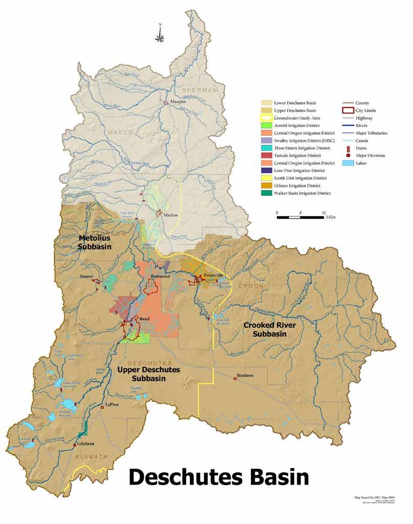
72
PROTECTING LAND & RESTORING RIVERS FOR SALMON & STEELHEAD
 PROTECTING LAND & RESTORING RIVERS FOR SALMON & STEELHEAD Whychus Creek at Camp Polk Meadow Preserve. Photo: Russ McMillan Top photo: Deschutes River Conservancy 1 Photo: Byron Dudley A Unique Collaboration
Water in the Deschutes Who needs it?
 Water in the Deschutes Who needs it? Rivers and streams over appropriation and flow alteration. Junior water right holders production agriculture. The Cities long-term supply for growing populations. Climate
middle deschutes progress in restoration
 middle deschutes progress in restoration Acknowledgements prepared by: Upper Deschutes Watershed Council Deschutes River Conservancy Oregon Department of Fish and Wildlife DESIGN & PRODUCTION FUNDED by:
Mid-Columbia Fisheries Enhancement Group Annual Report Fiscal Year 06: July 1, 2005 June 30, 2006
 Mid-Columbia Fisheries Enhancement Group Annual Report Fiscal Year 06: July 1, 2005 June 30, 2006 Mission Statement The mission of the Mid-Columbia Fisheries Enhancement Group is to restore self-sustaining
Deschutes Bull Trout
 Deschutes Bull Trout Existing Populations The Deschutes Bull Trout SMU is comprised of eight populations, three of which are classified as extinct (Table 1). Populations are identified according to those
FISHERIES BLUE MOUNTAINS ADAPTATION PARTNERSHIP
 FISHERIES A warming climate, by itself, substantially affects the hydrology of watersheds in the Blue Mountains. Among the key hydrologic changes projected under all scenarios for the 2040s and beyond
Restoring the Kootenai: A Tribal Approach to Restoration of a Large River in Idaho
 Restoring the Kootenai: A Tribal Approach to Restoration of a Large River in Idaho Susan Ireland, Kootenai Tribe of Idaho Future of our Salmon Conference Technical Session August 2016 Healthy Floodplains,
EXECUTIVE SUMMARY Preliminary System Improvement Plan
 EXECUTIVE SUMMARY Preliminary System Improvement Plan September 19, 2016 As the General Manager of Central Oregon Irrigation District, it has become apparent to myself and our staff that we need to modernize
Okanagan Sockeye Reintroduction
 Okanagan Sockeye Reintroduction Backgrounder Elders accounts, and other forms of Traditional Ecological Knowledge (TEK) tell us that many species of salmon once came into the Okanagan Valley and tell us
Funding Habitat Restoration Projects for Salmon Recovery in the Snake River Region SRFB Grant Round Version: 2/19/16
 2016 SRFB Grant Round Version: 2/19/16 Funding Habitat Restoration Projects for Salmon Recovery in the Snake River Region The Project Funding Process Presented by the Snake River Salmon Recovery Lead Entity
Climate Change Adaptation and Stream Restoration. Jack Williams;
 Climate Change Adaptation and Stream Restoration Jack Williams; jwilliams@tu.org 1 Goals for this presentation Develop strategies for adapting streams to climate impacts by Thinking like a watershed Understanding
Burns Paiute Tribe Fisheries Department. Evaluate The Life History Of Native Salmonids Within The Malheur Subbasin Project #
 Burns Paiute Tribe Fisheries Department Evaluate The Life History Of Native Salmonids Within The Malheur Subbasin Project # 199701900 Prior to 1990 Technical and/or scientific background Malheur population,
Trout Unlimited Comments on the Scope of Environmental Impact Statement for the Constitution Pipeline Project, Docket No. PF12-9
 October 9, 2012 Kimberly D. Bose, Secretary Federal Energy Regulatory Commission 888 First Street, NE, Room 1A Washington, DC 20426 RE: Trout Unlimited Comments on the Scope of Environmental Impact Statement
3. The qualification raised by the ISRP is addressed in #2 above and in the work area submittal and review by the ISRP as addressed in #1.
 Please find attached a response from The Confederated Tribes of the Warm Springs Reservation of Oregon (CTWSRO) for Project # 2008-301-00, Habitat Restoration Planning, Design and Implementation within
Deschutes Basin Habitat Conservation Plan. Working Group Meeting December 14, 2017 Redmond, Oregon
 Deschutes Basin Habitat Conservation Plan Working Group Meeting December 14, 2017 Redmond, Oregon AGENDA Welcome and Introductions News and Updates Proposed Conservation Measures Alternative Conservation
Deschutes River Conservancy Strategic Plan Executive Summary
 Deschutes River Conservancy Strategic Plan 2015-2025 Executive Summary 1 Mission The mission of the Deschutes River Conservancy (DRC) is to restore stream flow and improve water quality in the Deschutes
Chapter 9 Fish and Fish Habitat Redband Trout (photo credit: unknown)
") Redband Trout (photo credit: unknown) Chapter 9 Fish and Fish Habitat 185 CRITICAL QUESTIONS 1) What species of fish were historically present in the assessment area? 2) What is the current status of fish
Redband Trout (photo credit: unknown) Chapter 9 Fish and Fish Habitat 185 CRITICAL QUESTIONS 1) What species of fish were historically present in the assessment area? 2) What is the current status of fish
The Calawah River System
 The Calawah River System The Calawah River is the largest tributary of the Bogachiel River and is formed by the confluence of the north and south forks of the Calawah. The two forks of the Calawah, CALAWAH
STEELHEAD SURVEYS IN OMAK CREEK
 STEELHEAD SURVEYS IN OMAK CREEK 2002 Annual Report Prepared by Chris Fisher John Arterburn Colville Confederated Tribes Fish and Wildlife Department P.O. Box 150 Nespelem, WA 99155 Prepared for Project
Chagrin River TMDL Appendices. Appendix F
 Appendix F The following are excerpts from the Eastern Brook Trout Joint Venture s Conservation Strategy (Working Draft v.6), Conserving the Eastern Brook Trout: Strategies for Action Found at: http://www.easternbrooktrout.org/constrategy.html
OREGON DEPARTMENT OF FISH AND WILDLIFE
 OREGON DEPARTMENT OF FISH AND WILDLIFE Ladd Marsh Wildlife Area 1 Benefits for all Oregonians 2 The Mission To protect and enhance Oregon's fish and wildlife and their habitats for use and enjoyment by
CHAPTER 4 DESIRED OUTCOMES: VISION, GOALS, AND OBJECTIVES
 CHAPTER 4 DESIRED OUTCOMES: VISION, GOALS, AND OBJECTIVES Vision One of the first steps in developing this Plan was articulating a vision - a clear statement of what the Plan strives to achieve and what
1.Mill Creek Watershed Summary Description and Land Use
 1.Mill Creek Watershed Summary Description and Land Use Table xxx: Mill Creek Watershed Overview Watershed Size 31,435 acres/49.1 sq miles/ 127.1 sq km Elevation Range 5,594 feet [4,967-10,561] Stream
The Blue Heron Slough Conservation Bank
 1 The Blue Heron Slough Conservation Bank CONSERVATION BANKING July 19-23, 2010 CASE STUDY SERIES The Blue Heron Slough Conservation Bank (Washington) I. OVERVIEW & BACKGROUND: Location: Snohomish River
10 is bounded by wetlands between RM 1.8 and 3.1 on the south shore and more are scattered
 The Ozette System The Ozette watershed is made up of several lakes and large streams that combine to a total drainage area of 88.4 square miles. The most significant feature of the Ozette watershed is
Southern Oregon Coastal Cutthroat Trout
 Species Management Unit Description Southern Oregon Coastal Cutthroat Trout The Southern Oregon Coastal Cutthroat Trout SMU includes all populations of cutthroat trout inhabiting ocean tributary streams
FINAL REPORT. Yonkers Creek Migration Barrier Removal Project Wonderstump Road Del Norte County. Submitted By:
 FINAL REPORT Yonkers Creek Migration Barrier Removal Project Wonderstump Road Del Norte County Submitted By: Del Norte County Community Development Department Yonkers Creek Migration Barrier Removal Project
Little Kern Golden Trout Status:
 Little Kern Golden Trout Status: The Little Kern Golden trout (LKGT) was proposed for federal listing as Threatened under the Endangered Species Act (ESA) on September 1, 1977 by the U. S. Fish and Wildlife
Executive Summary. Map 1. The Santa Clara River watershed with topography.
 Santa Clara River Steelhead Trout: Assessment and Recovery Opportunities December 2005 Prepared By: Matt Stoecker and Elise Kelley, Ph.D. University of California, Santa Barbara Prepared For: The Santa
The. Plain Facts. What s happening on the Deschutes River
 The Plain Facts What s happening on the Deschutes River The Deschutes River system is an Oregon icon, treasured for its scenic beauty, the life-giving water it brings to the high desert, and its world-class
January 4, Addresses water quality within the Council program.
 Phil Rockefeller Chair Washington Tom Karier Washington Henry Lorenzen Oregon Bill Bradbury Oregon W. Bill Booth Vice Chair Idaho James Yost Idaho Pat Smith Montana Jennifer Anders Montana January 4, 2016
NEVADA DEPARTMENT OF WILDLIFE STATEWIDE FISHERIES MANAGEMENT
 NEVADA DEPARTMENT OF WILDLIFE STATEWIDE FISHERIES MANAGEMENT FEDERAL AID JOB PROGRESS REPORT F-20-50 2014 LAHONTAN CUTTHROAT TROUT STUDY WESTERN REGION NEVADA DEPARTMENT OF WILDLIFE, FISHERIES DIVISION
Klamath Lake Bull Trout
 Klamath Lake Bull Trout Existing Populations The Klamath Lake Bull Trout SMU is comprised of seven existing populations and four populations classified as extinct or functionally extinct (Table 189). Populations
2004 ANNUAL REPORT BOARD OF DIRECTORS
 2004 ANNUAL REPORT Enhancing and protecting the Upper Deschutes River watershed through collaborative projects in watershed stewardship, habitat enhancement, and community awareness. Dear Friends and Supporters,
FISH PASSAGE IMPROVEMENT in California s Watersheds. Assessments & Recommendations by the Fish Passage Forum
 FISH PASSAGE IMPROVEMENT in California s Watersheds Assessments & Recommendations by the Fish Passage Forum FISH PASSAGE IMPROVEMENT in California s Watersheds The mission of the Fish Passage Forum is
2012 Bring Back the Natives Awarded Projects
 2012 Bring Back the Natives Awarded Projects EZG # Organization Project Title Project Description Location Description Total Award Amount Grantee Non- Federal Match 31904 Sanctuary Forest, Inc. Mattole
Union Pacific Railroad
 Input Questions: 404/401 Pre Application Meeting, December 18, 2013, Portland, Oregon 1. What is the project purpose and need? The purpose of the project is to improve the efficiency and average velocity
For next Thurs: Jackson et al Historical overfishing and the recent collapse of coastal ecosystems. Science 293:
 For next Thurs: Jackson et al. 2001. Historical overfishing and the recent collapse of coastal ecosystems. Science 293: 629-637. Resource: means of supplying a want or deficiency, from French resourdre
Sub-watershed Summaries
 Project Description The Salmon Drift Creek Watershed Council (SDCWC) has focused their efforts in the Salmon River estuary for the past few years. The multifaceted partnership effort is nearing completion
UNIT 4E. SALMON SUPPLEMENTAL INFORMATION
 UNIT 4E. SALMON SUPPLEMENTAL INFORMATION In the STUDENT HANDOUTS/TEACHER PAGES Section of this unit, we have provided you with a host of information from various sources to supplement not only this unit,
MCCAW REACH RESTORATION
 Final Report MCCAW REACH FISH RESTORATION PHASE B Jack McCaw Inland Empire Action Coalition http://www.wwccd.net/ Phone: 509-956-3777 Hours: 8:00-4:30 Walla Walla County Conservation District Snake River
Kootenai River Habitat Restoration Program. Kootenai Tribe of Idaho - January 27, 2014 Presentation for Kootenai Valley Resource Initiative
 Kootenai River Habitat Restoration Program Kootenai Tribe of Idaho - January 27, 2014 Presentation for Kootenai Valley Resource Initiative Decline of native species Kootenai River White Sturgeon ENDANGERED
Warner Lakes Redband Trout
 Warner Lakes Redband Trout Existing Populations Warner Valley is an endorheic basin that contains a complex series of interconnected lakes, marshes, sloughs, and potholes, all of which are remnants of
Interim Guidance Fish Presence Absence
 Interim Guidance Fish Presence Absence Source: Forest Practices Act Guidance for Division 635 of the forest practices act dealing with stream classification when no fish surveys have been done (referenced
Minnesota Department of Natural Resources Division of Fish and Wildlife Section of Fisheries. Stream Survey Report. Luxemburg Creek.
 Minnesota F-29-R(P)-24 Area 315 Study 3 March 2016 Minnesota Department of Natural Resources Division of Fish and Wildlife Section of Fisheries Stream Survey Report Luxemburg Creek 2015 Mark Pelham Sauk
1.Warm Springs Creek (Anaconda) Watershed Description and Land Use
 Watershed Description and Land Use") 1.Warm Springs (Anaconda) Watershed Description and Land Use Table xxx: Warm Springs Watershed Overview Watershed Size 92,288 acres/144.2 sq miles/373.6 sq km Elevation Range 5,781 feet [4,800-10,581]
1.Warm Springs (Anaconda) Watershed Description and Land Use Table xxx: Warm Springs Watershed Overview Watershed Size 92,288 acres/144.2 sq miles/373.6 sq km Elevation Range 5,781 feet [4,800-10,581]
Yakima/Klickitat Fisheries Project
 Yakima/Klickitat Fisheries Project Lower Yakima River Supplementation and Research Project Operations and Maintenance Annual Report 2002-2003 March 2004 DOE/BP-00006677-1 This Document should be cited
COA-F17-F-1343 YEAR END REPORT
 DAVE MARSHALL SALMON RESERVE RESTORATION, MAINTENANCE, AND UPGRADES YEAR END REPORT Prepared for: Fish and Wildlife Compensation Program Prepared by: Edith Tobe, RPBio, Executive Director Box 1791, Squamish,
Amendment to a Biological Assessment/Evaluation completed for the Coon Creek Land Disposal completed December Grand Valley Ranger District
 Amendment to a Biological Assessment/Evaluation completed for the Coon Creek Land Disposal completed December 2007 Grand Valley Ranger District Grand Mesa, Uncompahgre, Gunnison National Forests Prepared
La Crescent Township Zoning Ordinance
 La Crescent Township Zoning Ordinance Table of Contents SECTION 1 ~ PREAMBLE, TITLE, SHORT TITLE AND PURPOSE... 1 0101 Preamble... 1 0102 Title... 1 0103 Short Title... 1 0104 Purpose... 1 SECTION 2 ~
Dear Friends and Supporters,
 2005 ANNUAL REPORT Enhancing and protecting the Upper Deschutes River watershed through collaborative projects in watershed stewardship, habitat enhancement, and community awareness. BOARD OF DIRECTORS
Columbia Lake Dam Removal Project
 Columbia Lake Dam Removal Project The Columbia Lake dam located 1/4 mile upstream of the Paulins Kill River's confluence with the Delaware River in Knowlton Township, Warren County has been proposed for
PROJECT TO INSTALL LARGE WOOD HABITAT STRUCTURES IN THE CARMEL RIVER USING CALIFORNIA DEPARTMENT OF FISH AND GAME GRANT FUNDS
 PROJECT TO INSTALL LARGE WOOD HABITAT STRUCTURES IN THE CARMEL RIVER USING CALIFORNIA DEPARTMENT OF FISH AND GAME GRANT FUNDS The Monterey Peninsula Water Management District (MPWMD), in cooperation with
Five Counties Salmonid Conservation Program - Fish Passage Design Workshop. February 2013
 Program - Aquatic Organisms and Stream Crossings Ecological Connectivity A watershed is a network of channels that drain a common boundary. Channel characteristics formed by interaction of precipitation,
Throughout the Pacific Northwest, salmon and steelhead have been listed under the Endangered Species Act because their existence is either threatened
 Throughout the Pacific Northwest, salmon and steelhead have been listed under the Endangered Species Act because their existence is either threatened or endangered. The Upper Willamette River Basin s spring
Final Bull Trout Genetics Monitoring Plan for the Wallowa Falls Hydroelectric Project. (FERC No. P-308) June 2017
 June 2017") Final for the Wallowa Falls Hydroelectric Project (FERC No. P-308) June 2017 Prepared by: Jeremiah Doyle PacifiCorp 825 NE Multnomah Street Portland, OR 97232 June, 2017 Page 1 of 8 Table of Contents 1.0
Final for the Wallowa Falls Hydroelectric Project (FERC No. P-308) June 2017 Prepared by: Jeremiah Doyle PacifiCorp 825 NE Multnomah Street Portland, OR 97232 June, 2017 Page 1 of 8 Table of Contents 1.0
Western native Trout Status report
 Bull trout (Salvelinus confluentus) Data: Draft Recovery Plan, USFWS, 2002; FR Final Critical Habitat Rule - 2005 Partners: ID, MT, OR, WA, NV, FWS, FS, BLM, NPS, Tribes, AK, Canada Species Status review:
ESCA. Endangered Species Conservation Act of 1969 Changed in 1973 to ESA Amended several times
 ESCA Endangered Species Conservation Act of 1969 Changed in 1973 to ESA Amended several times International Efforts http://www.cites.org/ Convention on International Trade in Endangered Species of Wild
Concurrent Sessions C: Prioritization - Oregon Fish Passage Priority List - A Statewide Barrier Prioritization Effort
 University of Massachusetts - Amherst ScholarWorks@UMass Amherst International Conference on Engineering and Ecohydrology for Fish Passage International Conference on Engineering and Ecohydrology for Fish
Project Award Presentation
 University of Massachusetts Amherst ScholarWorks@UMass Amherst International Conference on Engineering and Ecohydrology for Fish Passage International Conference on Engineering and Ecohydrology for Fish
California Steelhead: Management, Monitoring and Recovery Efforts
 California Steelhead: Management, Monitoring and Recovery Efforts Jonathan Nelson Steelhead Management, Research and Restoration Program Oncorhynchus mykiss irideus California Steelhead - Hot Topics Implementation
Eastern Brook Trout. Roadmap to
 Eastern Brook Trout Roadmap to CONSERVATION Our Brook Trout heritage he wild Brook Trout is an American symbol of persistence, adaptability, and the pristine wilderness that covered North America prior
Strategies for mitigating ecological effects of hatchery programs
 Strategies for mitigating ecological effects of hatchery programs Some case studies from the Pacific Northwest Kathryn Kostow Oregon Department of Fish and Wildlife Ecological risks occur when the presence
Salmon Biology Station
 Salmon Biology Station OBJECTIVES: Students learn: Wild salmon are indicator species and keystone species whose survival is connected to the health of the watershed. o Riparian salmon need trees and trees
A Comparison of Western Watershed Councils. Presentation Prepared by Jeff Salt, Great Salt Lakekeeper
 A Comparison of Western Watershed Councils Presentation Prepared by Jeff Salt, Great Salt Lakekeeper Presentation Overview Introduction Jordan River Watershed Council Lower Boise Watershed Council Clackamas
5B. Management of invasive species in the Cosumnes and Mokelumne River Basins
 5B. Management of invasive species in the Cosumnes and Mokelumne River Basins Cosumnes River The Cosumnes River basin has a number of distinct habitat types that require different management strategies
Rehabilitation of Grimes Creek, a Stream Impacted in the Past by Bucket-lined Dredge Gold Mining, Boise River Drainage, July 2008 to August 2011.
 Rehabilitation of Grimes Creek, a Stream Impacted in the Past by Bucket-lined Dredge Gold Mining, Boise River Drainage, July 2008 to August 2011. Pam Harrington TU,1020 W. Main Street Suite 440, Boise,
Table xxx: Listed and Suspected Impairments for Willow Creek 2010 Reach Impairment Pollutant Impaired Uses
 1. (Fairmont) Watershed Summary Description and Land Use Table xxx: (Fairmont) Watershed Overview Watershed Size 18,331 acres/28.7 sq miles/74.3 sq km Elevation Range 2,615 feet [4,980-7,595] Stream Miles
Searsville Dam Removal
 Searsville Dam Removal A unique opportunity for all Presented by the Beyond Searsville Dam Coalition San Francisquito Creek flows into the San Francisco Bay near the Palo Alto Airport and Golf Course seen
Implementing the New Fisheries Protection Provisions under the Fisheries Act
 Implementing the New Fisheries Protection Provisions under the Fisheries Act Discussion Paper Fisheries and Oceans Canada April 2013 Contents 1. Introduction 2. Managing Threats to Canada s Fisheries 3.
Columbia Lake Dam Removal Project
 Columbia Lake Dam Removal Project Major Goals of the Columbia Lake Dam Removal: Reconnect 10 miles of the Paulins Kill River to the Delaware River, restoring natural flow regime and sediment transport.
Oregon Department of Fish and Wildlife: Inland Fisheries - Hatchery Management
 Oregon Department of Fish and Wildlife: Inland Fisheries - Hatchery Management Primary Outcome Area: Economy & Jobs Secondary Outcome Area: Healthy Environments Program Contact: Ed Bowles, 503-947-6206
Conserving the Forests, Lakes and Streams of Northeast Michigan
 4241 Old US 27 South, Suite 2, Gaylord, Michigan 49735 (989) 448-2293 www.huronpines.org info@huronpines.org Prioritized Restoration Projects in the AuSable River Watershed Summer 2015 Update from Huron
OVERVIEW OF MID-COLUMBIA FISHERIES ENHANCEMENT GROUP
 Mid-Columbia Fisheries Enhancement Group MISSION STATEMENT The Mid-Columbia Fisheries Enhancement Group is a non-profit organization dedicated to restoring selfsustaining salmon and steelhead populations
OREGON DEPARTMENT OF FISH AND WILDLIFE ROGUE FISH DISTRICT REPORT
 OREGON DEPARTMENT OF FISH AND WILDLIFE ROGUE FISH DISTRICT REPORT TITLE: Upper Rogue Smolt Trapping Project, 1999 STREAM: Big Butte, Little Butte, South Fork Big Butte, Slate and West Fork Evans Creeks
U.S. Fish and Wildlife Service Native American Crosscut Funding
 U.S. Fish and Wildlife Service Native American Crosscut Funding Tribal / Interior Budget Council National Budget Meeting L Enfant Plaza Hotel Washington, DC November 8, 2013 U.S. Fish and Wildlife Service
INVASIVE SPECIES MANAGEMENT OPTIONS FOR THE DOS PALMAS AREA
 INVASIVE SPECIES MANAGEMENT OPTIONS FOR THE DOS PALMAS AREA Revised Draft Report June 9, 2009 Overview Background Site Characterization Species Biology Invasive Species Distribution Invasive Species Control
Steelhead Society of BC. Thompson River Watershed Restoration and Enhancement Project #4 Nicola River Bank Stabilization and Enhancement Project
 Steelhead Society of BC Presents: Thompson River Watershed Restoration and Enhancement Project #4 Nicola River Bank Stabilization and Enhancement Project Application for Funding December 2013 1.0 BACKGROUND
COLUMBIA LAKE DAM REMOVAL PROJECT
 COLUMBIA LAKE DAM REMOVAL PROJECT Major Goals of the Columbia Lake Dam Removal: Reconnect 10 miles of the Paulins Kill River to the Delaware River, restoring natural flow regime and sediment transport.
San Lorenzo Valley Water District, Watershed Management Plan, Final Version Part I: Existing Conditions Report
 LIST OF FIGURES Figure 1-1. Map of the San Lorenzo River watershed Figure 2-1. The Santa Cruz Mountains Bioregion Figure 2-2. Protected areas within the San Lorenzo River watershed Figure 2-3. Primary
Big Spring Creek Habitat Enhancement and Fishery Management Plans
 Big Spring Creek Habitat Enhancement and Fishery Management Plans November 5, 2012 Big Spring Events and Activities Center Newville, PA Charlie McGarrell Regional Habitat Biologist Pennsylvania Fish and
Klickitat County Shoreline Master Program Update. Open House March 15, 2017
 Klickitat County Shoreline Master Program Update Open House March 15, 2017 Agenda 6:00 6:10 Welcome 6:10 6:40 Presentation SMP Update Process Shoreline Analysis review 6:40 8:00 Open House Topics SMP Process
Rhode Island Department of Environmental Management Division of Fish and Wildlife American Shad Habitat Plan for the Pawcatuck River
 Rhode Island Department of Environmental Management Division of Fish and Wildlife American Shad Habitat Plan for the Pawcatuck River Prepared by: Phil Edwards, Rhode Island Department of Environmental
Abundance of Steelhead and Coho Salmon in the Lagunitas Creek Drainage, Marin County, California
 scanned for KRIS Abundance of Steelhead and Coho Salmon in the Lagunitas Creek Drainage, Marin County, California Prepared for: Marin Municipal Water District 220 Nellen Drive Corte Madera, California
NEVADA DEPARTMENT OF WILDLIFE STATEWIDE FISHERIES MANAGEMENT FEDERAL AID JOB PROGRESS REPORTS F LAHONTAN CUTTHROAT TROUT EASTERN REGION
 NEVADA DEPARTMENT OF WILDLIFE STATEWIDE FISHERIES MANAGEMENT FEDERAL AID JOB PROGRESS REPORTS F-20-50 2014 LAHONTAN CUTTHROAT TROUT EASTERN REGION NEVADA DEPARTMENT OF WILDLIFE, FISHERIES DIVISION ANNUAL
Salmon River Cooperative Noxious Weed Program (CNWP) Presented by the Salmon River Restoration Council
 Presented by the Salmon River Restoration Council") Salmon River Cooperative Noxious Weed Program (CNWP) Presented by the Salmon River Restoration Council Some of you may be thinking So where is Salmon River? Isn t it in Idaho, Washington, or Oregon? The
Salmon River Cooperative Noxious Weed Program (CNWP) Presented by the Salmon River Restoration Council Some of you may be thinking So where is Salmon River? Isn t it in Idaho, Washington, or Oregon? The
Deschutes River Reintroduction
 Deschutes River Reintroduction The rebirth of a world-class steelhead and salmon fishery in the Upper Deschutes faces many challenges. Tom Davis and Russell Bassett, Northwest Steelheaders For more than
WFC 50 California s Wild Vertebrates Jan. 11, Inland Waters (Lakes and Streams) Lisa Thompson
 Lisa Thompson") Inland Waters: Lakes and Streams WFC 50 11 January 2011 Lisa Thompson Fisheries Extension Specialist Wildlife, Fish, & Conservation Biology Department University of California, Davis Take home messages
Inland Waters: Lakes and Streams WFC 50 11 January 2011 Lisa Thompson Fisheries Extension Specialist Wildlife, Fish, & Conservation Biology Department University of California, Davis Take home messages
Illinois Lake Management Association Conference March 23, 2018 By Trent Thomas Illinois Department of Natural Resources Division of Fisheries
 Illinois Lake Management Association Conference March 23, 2018 By Trent Thomas Illinois Department of Natural Resources Division of Fisheries Sources of Habitat Impairment Sedimentation Channelization
Fisheries Management Plan Idaho Department of Fish and Game
 Fisheries Management Plan 2007-2012 2012 Idaho Department of Fish and Game Plan History 1981-1985 1985 Plan Separate anadromous plan Evolved from 5 to 6-year 6 plan Angler Opinion Survey The Process Public-Agency
P.O. Box 65 Hancock, Michigan USA fax
 This PDF file is a digital version of a chapter in the 2005 GWS Conference Proceedings. Please cite as follows: Harmon, David, ed. 2006. People, Places, and Parks: Proceedings of the 2005 George Wright
Benchmark Statement Respecting the Fish, Fish Habitat and Fisheries of Fish and Little Fish Lake, within the Taseko River Watershed.
 Benchmark Statement Respecting the Fish, Fish Habitat and Fisheries of Fish and Little Fish Lake, within the Taseko River Watershed. Information Supporting the Environmental Assessment of the Prosperity
Statement of Dr. Jack Williams Senior Scientist, Trout Unlimited. Before the
 Statement of Dr. Jack Williams Senior Scientist, Trout Unlimited Before the Subcommittee of Water and Power Energy and Natural Resources Committee United States Senate June 6, 2007 Mr. Chairman, Members
Past, Present and Future Activities Being Conducted in the Klamath River Basin Related to the Protection and Recovery of Fish and Their Habitat
 Past, Present and Future Activities Being Conducted in the Klamath River Basin Related to the Protection and Recovery of Fish and Their Habitat National Marine Fisheries Service March 2003 The Department
Annual Report for Fiscal Year and Future Plans for the Tillamook Bay Watershed Council
 Annual Report for Fiscal Year 2012-2013 and Future Plans for the Tillamook Bay Watershed Council A report prepared for the Tillamook County Board of Commissioners August 2013 Table of Contents: Recently
Trout Buffer Variance
 Trout Buffer Variance Ashley L. Rodgers, PE Spring 2015 Why a Trout Buffer Capturing pollutants in runoff to keep the water clean. Capturing sediment to keep mud out of the water. Providing shade to keep
Backgrounder and Frequently Asked Questions
 Backgrounder and Frequently Asked Questions Who Sent the Letter? The 60-day Notice of Intent to File Suit was sent by Conservation Angler, Wild Fish Conservancy, Snake River Waterkeeper, Friends of the
Maryland Chapter Trout Unlimited Brook Trout Conservation Effort
 Maryland Chapter Trout Unlimited Brook Trout Conservation Effort Photo by Matt Kline Portfolio of Recent Work MDTU Brook Trout Conservation Coordinator: Scott C. Scarfone, ASLA sscarfone@oasisdesigngroup.com
PRE- PROPOSAL FORM - Lewis River Aquatic Fund
 PRE- PROPOSAL FORM - Lewis River Aquatic Fund 1. Applicant organization. USDA Forest Service Gifford Pinchot National Forest 2. Organization purpose Resource management agency 3. Project manager (name,
Proposed Reclassification of Muskrat Creek, North Platte River Basin in Goshen County, Wyoming
 Proposed Reclassification of Muskrat Creek, North Platte River Basin in Goshen County, Wyoming October 25, 2010 Waterbody: Muskrat Creek - Mainstem of Muskrat Creek from its headwaters downstream to its