A 1994 UNIONID MUSSEL SURVEY (MOLLUSCA: BIVALVIA: UNIONIDAE) FROM THE HEADWATERS OF THE ROOT RIVER SYSTEM, MN, TO THE MISSISSIPPI RIVER.
|
|
|
- Howard Hodge
- 5 years ago
- Views:
Transcription
1 Conservation Biology Research Grants Program Division of Ecological Services Minnesota Department of Natural Resources 1 A 1994 UNIONID MUSSEL SURVEY (MOLLUSCA: BIVALVIA: UNIONIDAE) FROM THE HEADWATERS OF THE ROOT RIVER SYSTEM, MN, TO THE MISSISSIPPI RIVER. BY MARIAN E. HAVLIK MALACOLOGICAL CONSULTANTS 1603 MISSISSIPPI STREET LA CROSSE, WI FINAL REPORT JUNE 1995 FOR MINNESOTA DEPARTMENT OF NATURAL RESOURCES NONGAME RESEARCH PROGRAM Box 7, 500 LAFAYETTE ROAD ST. PAUL, MN
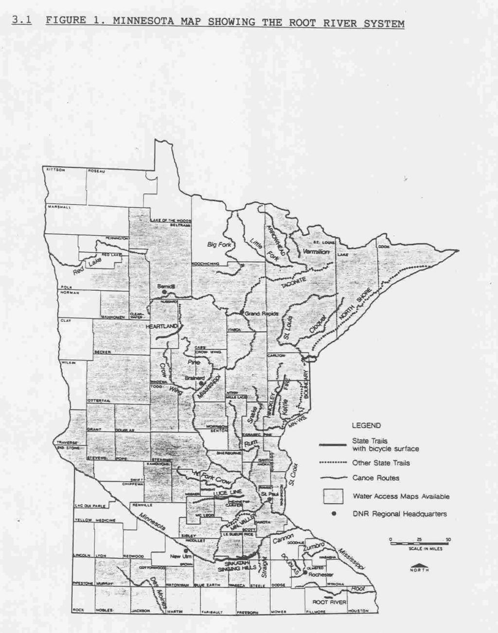
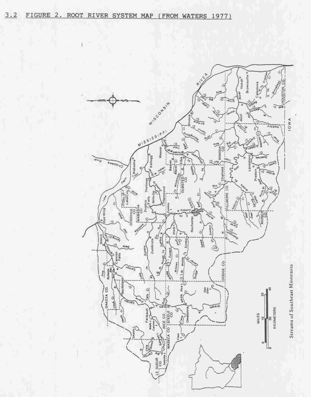
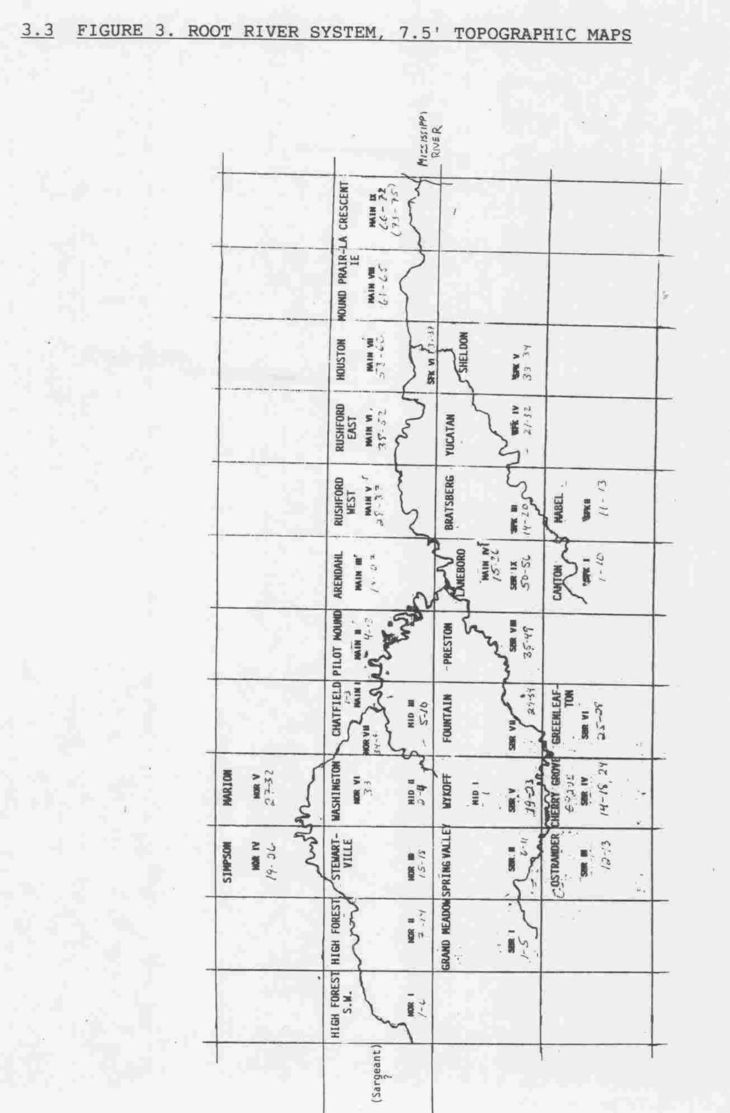
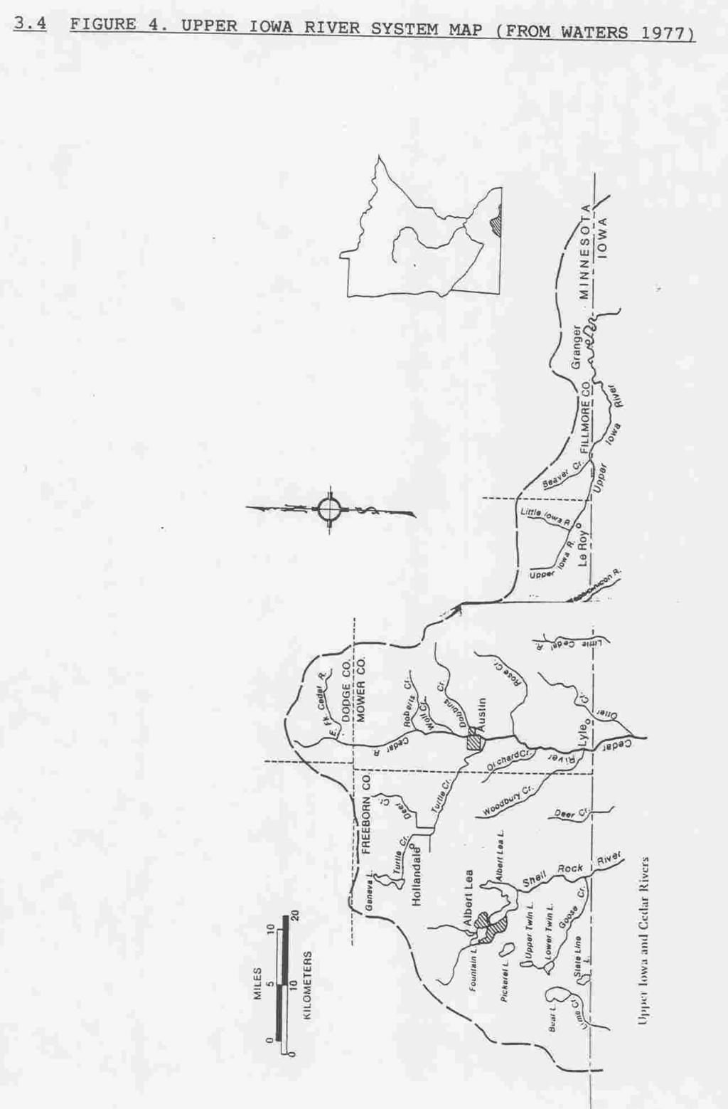
2 2 TABLE OF CONTENTS 1 ABSTRACT INTRODUCTION AND BACKGROUND METHODS FIGURE 1. MINNESOTA MAP SHOWING THE ROOT RIVER SYSTEM FIGURE 2. ROOT RIVER SYSTEM MAP (FROM WATERS 1977) FIGURE 3. ROOT RIVER SYSTEM, 7.5' TOPOGRAPHIC MAPS FIGURE 4. UPPER IOWA RIVER SYSTEM MAP (FROM WATERS 1977) 7 4 RESULTS 4.1 VOLUNTEER HELP AND PUBLIC INVOLVEMENT..9 5 DISCUSSION NORTH BRANCH ROOT RIVER, MN, JUNE MIDDLE BRANCH ROOT RIVER, MN, JUNE DEER, BEAR, AND SPRING VALLEY CREEKS SOUTH BRANCH ROOT RIVER, MN, JUNE SOUTH FORK ROOT RIVER, MN, JUNE MAIN STEM ROOT RIVER, MN, JUNE UPPER IOWA RIVER, MN, SITES, JUNE LITTLE IOWA RIVER, MN, SITES, JUNE DISCUSSION OF Venustaconcha e. ellipsiformis (Conrad, 1836) OTHER ROOT RIVER SYSTEM UNIONID SPECIES RECOMMENDATIONS AND PRELIMINARY CONCLUSIONS ACKNOWLEDGMENTS LITERATURE CITED APPENDIX TABLE 1. UNIONID MOLLUSKS, ROOT RIVER SYSTEM, MN, JUNE TABLE 2. UNIONID MOLLUSKS, ROOT RIVER SYSTEM, MN, BY BRANCH TABLE 3. UNIONID SPECIES FREQUENCY OF OCCURRENCE, JUNE MISCELLANEOUS CORRESPONDENCE....26
3 1 1 ABSTRACT A 1994 UNIONID MUSSEL SURVEY (MOLLUSCA: BIVALVIA: UNIONIDAE) FROM THE HEADWATERS OF THE ROOT RIVER SYSTEM, MN, TO THE MISSISSIPPI RIVER. Marian E. Havlik, Malacological Consultants 1603 Mississippi Street, La Crosse, WI The Root River of Minnesota apparently has never been surveyed for unionid mussels. This report gives the results of sampling for unionids from 6-17 June 1994 at 117 bridge and road access sites between the Root River system headwaters and the Mississippi River. We also sampled sites on the nearby Upper Iowa (2) and Little Iowa Rivers (8), for a total of 127 sites. The main stem of the Root River starts just NE of Lanesboro, MN, at the confluence of the North and Middle Branches, and flows easterly to its confluence with the Mississippi River, between La Crescent and Brownsville, MN. Sampling consisted of wading and shoreline searches in the headwaters and middle reaches of the Root River system, and shoreline searches by boat in the lower six miles of the Root River from Hokah, MN, to the, river's mouth. This Root River survey included the main stem and all four major tributaries, and yielded at least 16 unionid mussel species. However, only three species were found alive, represented by five living mussels: Venustaconcha e. ellipsiformis (Conrad, 1836), Ellipse (3), and Lampsilis radiata luteola (Lamarck, 1819), Fatmucket (1) were found at one South Branch site, 0.5 mi N of Etna, MN, and one Anodontoides ferussacianus (Lea, 1834) Cylindrical Papershell, was found at a North Branch site, 4 mi NW of Dexter, MN. A number of the remaining species were represented by fairly fresh-dead shells. The most species (12) were found in the North Branch of the Root River, among 22 sites, however the most shells were found in the South Branch among 40 sites (nine species). Eleven species were found among eight sites on the Middle Branch of the Root River. The most common species found, both dead and alive, Venustaconcha e. ellipsiformis, also lives in the Cannon and Zumbro Rivers of southeastern Minnesota, but apparently was not found in western Wisconsin for over 60 years, until , when it was found in a tributary of the Chippewa River, near Cadott, WI. Overall, our data show severe impacts to the 117 sites on the Root River system. We were unable to pinpoint the precise impacts that led to this situation, but our preliminary conclusions are that cumulative impacts, primarily agricultural, are apparently responsible. Since the Zebra Mussel is exploding in the Mississippi system, we must quickly identify tributary molluscan fauna, or risk losing unique populations before they can be identified. We hope to have additional funding to complete areas not sampled in 1994, including portions of the North Branch, South Branch, and Root River main stem, plus a number of tributary creeks.
4 2 2 INTRODUCTION AND BACKGROUND In recent times about 30 unionid mussel species have been reported alive from Pool 8 of the Mississippi Rivet between Brownsville, MN, and La Crescent, MN (Fuller 1978, 1980a, 1980b; Havlik 1980, 1983), including, the endangered Lampsilis higginsi (Lea, 1857), Higgins' Eye, and other rare Upper Mississippi River species, such as Anodonta suborbiculata Say, 1831, Flat Floater. A. suborbiculata was first reported in a Wisconsin backwater slough, Mississippi River Pool 8, in 1978 (Havlik 1981). This species has been expanding upstream in the Mississippi River system, apparently taking advantage of slower waters created by the locks and dams. The overall unionid fauna of the Mississippi River between Minnesota and Wisconsin, including Pool 8, is quite well known, although specific distribution patterns are not well understood (Baker 1928; Dawley 1944, 1947; van der Schalie and van der Schalie 1950; Fuller 1978, 1980a, 1980b; Havlik 1983; Thiel 1981). Some Minnesota tributaries of the Mississippi River, such as the Root River, have apparently never been sampled intensively for unionid mollusks. The Root River system, with a watershed of 1670 square miles (Waters 1977), starts over 90 miles W its confluence with the Mississippi River S of La Crescent, MN (Figures 1, 2, 3). The Root River drops 550 feet from its headwaters to the Mississippi River (Waters 1977). Because erosion problems with the Root River fisheries, Thaddeus Surber (1924, in Waters 1977) conducted a biological survey of the Root River system in the early 1920's, walking over 1000 miles recording fish species seen in the various tributaries of the system. Sound management practices are difficult to impossible, if the organisms to be managed have not been identified and quantified, particularly if there are federal and state endangered and rare species nearby. In addition, there are potential impacts from the exotic Zebra Mussel, Dreissena polymorpha (Pallas 1771), whose populations are exploding in the nearby Mississippi River. During September 1993, Malacological Consultants conducted a unionid mollusk survey at 150 sites on the Elkhorn River in north-central Nebraska (Clausen and Havlik 1994). Due to the nature of the 300 mile long Elkhorn River and major tributaries, most sampling was done at bridge crossings and road access points. We expected that a unionid mussel survey of the Root River would have be conducted similarly, so the same sampling methods were proposed for this Root River project. The Elkhorn River once had as many as 30 mussel species. However, we only found seven living species among 231 living mussels, mainly from the upper reaches of the main stem of the Elkhorn, and in the lower reaches of major tributaries. The moat abundant mussel bed found was in an upstream tributary, less than three meters wide. This Root River study was proposed to fill part of the data gaps in Minnesota's faunal inventories. Field work is necessary to refine inventory data and to identify any rare species populations. 3 METHODS
5 3 Bridge and road access points were determined on ' topographic maps encompassing the Root River system of southeastern Minnesota. The main stem of the Root River begins near Chatfield, MN, at River Mile The headwaters of major tributaries are N of Renova, MN (North Branch), W of Fillmore, MN (Middle Branch), S of Grand Meadow, MN (South Branch), and NE of Harmony, MN (South Fork) (Figures 1, 2, 3). The southern portion of this area, near the Minnesota - Iowa border, contains the headwaters of the Little Iowa River, which is a tributary of the Upper Iowa River (Figure 4). Initially we had intended to start with the Main Stem of the Root River, but two days of sampling on the lower Root River from its junction with the Mississippi River and upstream on the Root River to Hokah, MN, plus sampling at several areas near Lanesboro, MN, were generally non-productive. Given the results of the Elkhorn River, NE, study, we then decided to start at the extreme headwaters of each major Root River tributary, and methodically work our way downstream sampling every bridge site and road access. At each site random sampling was done to the point of diminishing returns. One person proceeded upstream for up to 200 m at each site, and another person proceeded downstream for about the same distance, averaging about 50 m in each direction. Searches were conducted in the water where possible, and along the shoreline, and in the shoreline vegetation. Living mussels were identified, enumerated, aged, measured, and retained, as practical. Empty shells, valves, and fragments were also identified, enumerated, and retained, when practical. Representative voucher specimens from most sites were deposited at the J. F. Bell Museum, University of Minnesota, Minneapolis, MN. Some specimens were also sent to The Ohio State University Museum of Biological Diversity, Columbus, OH. All specimens were grossly examined for Dreissena polymorpha. We used four county maps to help determine localities, and to determine the physical relationship of various Root River branches to each other and to the River system. Sampling locations were plotted on 7.5 minute topographic maps. Field sheets were designed for this project. Locale and other data were recorded on a separate sheet for each site. Some colored slides were taken throughout the study area.
6 4
7 5
8 6
9 7
10 8 4 RESULTS From 6 to 17 June 1994, 117 sites on the Root River system were surveyed at bridge and road access sites from the headwaters, to the Mississippi River, to determine the presence of unionid mollusks, their distribution, diversity, and relative abundance. We also sampled two sites on the nearby Upper Iowa River, and eight sites on the nearby Little Iowa River, for a total of 127 sites. This survey, which included portions of the main stem and four major tributaries, yielded at least 16 species of unionid mollusks (Table 1). However, only three living unionid species were found, represented by five living mussels (Table 2). Several empty shells need further study to confirm their identification. Some unionids were aged, and measured for length to the nearest mm. We've found length to be the most important measurement based on our work at Prairie du Chien, WI (Havlik and Stein 1993). Mussels were sexed as practical. Specimens were enumerated on a separate field sheet for each site. Visual habitat observations were recorded as appropriate. Empty shells were enumerated and identified, and most were retained as practical. In actual abundance, Venustaconcha e. ellipsiformis was the species most often found with over 200 specimens from 16 sites (Table 3). The species that occurred most frequently was Anodonta grandis f. grandis Say, 1829, Floater, which was found at 32 sites. Lasmigona complanata (Barnes, 1823), White Heelsplitter, was found at 15 sites. Strophitus u. undulatus (Say, 1817), Strange Floater, and Lampsilis ventricosa (Barnes, 1823), Pocketbook, were each found at 14 sites, while Lampsilis radiata luteola (Lamarck, 1819), Fatmucket, and Anodontoides ferussacianus (Lea, 1834) Cylindrical Papershell, were found at 13 and 12 sites respectively. Seven unionid species were found at 12 or more sites, while the remainder were found at seven or fewer sites, including three species found at only one site each (Table 3). No Dreissena polymorpha, Zebra Mussels, were found. Root River system sampling sites were plotted on minute topographic maps. Sites were numbered starting with the headwaters of each river segment, including the Root River main stem. Each site was given a number on both the field sheet and the maps, such as SB1 (South Branch, Site 1), or SF25 (South Fork, Site 25) etc. On the second day of this study we started at the confluence with the Mississippi River. Three persons proceeded upstream via boat for six miles to Hokah, MN, looking for mussels shells along the river banks and sandbars. No unionids were found, dead or alive. The following number of sites have been sampled on each segment of the Root River system. Sampling on the South Fork and Middle Branch has been completed, but not on their tributaries. The number of sites remaining to be sampled on other river segments, plus their tributaries, are listed below.
11 9 NUMBER OF SITES DONE, AND REMAINING, ROOT RIVER SYSTEM, JUNE 1994 DONE REMAINING (estimated) ROOT RIVER MAINSTEM MISC. TRIBUTARY CREEKS SOUTH BRANCH SOUTH FORK (completed) 27 - MIDDLE BRANCH (completed) 8 - MIDDLE BRANCH TRIBUTARIES: DEER CREEK 3 24 BEAR CREEK 2 45 SPRING VALLEY CREEK - 24 NORTH BRANCH MISCELLANEOUS TRIBUTARY CREEKS 1 25 UPPER IOWA RIVER 2 - LITTLE IOWA RIVER (completed) VOLUNTEER HELP AND PUBLIC INVOLVEMENT We solicited volunteer help for the 1994 Root River study. Students from several southeastern Minnesota high schools, and three supervisors, all working for the Private Industry Council, Inc., Caledonia, MN, assisted us for two days in the field. All volunteers were required to wear life jackets when working in the Root River. Thus, 14 students aged 14 to 17, plus their supervisors including Wayne Highum, local Director of the Private Industry Council, were given a real life biological research experience on the South Branch of the Root River, both upstream and downstream of the Mystery Cave complex (Appendix: Miscellaneous Correspondence). The enthusiastic response of our young volunteers was most rewarding. They wanted to continue working with us, but unfortunately not all areas of the Root River system are suitable for wading (too deep), and in one area a local landowner warned that a creek flowed over the Mystery Cave System, and that the stream bed might not be safe to walk on. In addition, at that point nearly all of our time allotted for field work had been used up. Student volunteers however, could be very helpful on the smaller creeks. We also spoke to the Fillmore County Water Resources Board, Tuesday, 14 June 1994 (Appendix: Miscellaneous Correspondence). A general slide presentation and display was given to about 10 persons. Questions were answered on the importance of mussels in the Root River ecosystem to give the Board insight into problems with the River system. A statement was included that this Root River project was funded by the Minnesota Nongame Wildlife Program from contributions to the Minnesota Nongame Wildlife Tax Checkoff. We were not aware of any other media coverage for this project. 5 DISCUSSION This Root River study was essentially conducted by the same team that conducted the Elkhorn River, Nebraska, study (Clausen and Havlik 1994). This
12 10 crew is very experienced at quickly assessing the presence or absence of mussels. Thus if unionids were present, we should have at least found evidence of empty shells, and sometimes did at some distance away from the river channel. Based on our 1993 experiences at 150 sites on the Elkhorn River,. Nebraska, if unionids are present, they are more likely be found near or upstream of the midpoint of a small river system. But, because of a reasonably diverse unionid fauna in the nearby Mississippi River, unionids should also be present in the lower Root River, although they may be more difficult to find, unless brailing is feasible, or low water conditions reveal shells on sandbars or shorelines. If we had sampled only at every other road access or bridge site, we could have missed our more productive sites, particularly at the site two miles W of Mystery Cave #1 (0.5 mile N of Etna, MN). No quantitative sampling was done, because no mussel concentrations were found. In many areas quantitative sampling would be very time consuming because of largely broken bedrock substrata. We would only consider recommending a few sites for quantitative sampling. The lower Root River is known to carry a considerable sediment load. This sediment load is evidenced by the frequent need for U.S. Army Corps of Engineers navigation channel maintenance dredging downstream of its confluence with the Mississippi River, and near Brownsville, MN. In May 1985 the Principal Investigator briefly took her john boat about two miles up the Root River, nearly to the Hwy 26 bridge, and did not note any obvious mussel concentrations or shoreline middens at that time. The most common unionid species found, dead and alive, in southeastern Minnesota, Venustaconcha e. ellipsiformis (Conrad, 1836), Ellipse Shell, apparently has not been reported in western Wisconsin for over 60 years, although the species has been found alive in eastern Minnesota since the 1980's in the Cannon, Straight, and Zumbro Rivers (Davis 1988, Bright et. al 1989). In May 1995 it came to our attention that living specimens of Venustaconcha e. ellipsiformis had been found in the Yellow River, Cadott, WI, (Dr. Terry Balding, personal communication). That site is about 100 river miles from the Mississippi River, about the same distance as the more productive V. e. ellipsiformis sites on the Root River system. For a further discussion of V. e. ellipsiformis see Section 5.8. Waters (1977) states that the adverse agricultural impacts actually started in the 1840's when European man began settlement and farming in Houston County, in southeastern Minnesota. In 1994 cattle, horses, and pigs were observed in the Root River system in many areas. Some headwater fields are tiled and drained, particularly on the South Branch. Agricultural use is heavy throughout much of the Root River system, with steep, eroding river-banks in many areas. Hove and Neves (1994) stated that road construction, cattle grazing, and feed lots that often introduce excessive silt and nutrients into a stream, were the most detrimental activities to the continued existence of Pleurobema collina (Conrad, 1837), James Spinymussel, a federally endangered unionid mussel endemic to the James River watershed, near Richmond, Virginia.
13 11 Since nearly all of the riparian lands bordering streams with P. collina were privately owned, any increased, intensive use of riparian habitat would probably deteriorate water quality and thus habitat suitability. During life history studies of P. collina, Hove and Neves (1994, p. 34) were led to believe that two species of Catostomidae (white sucker and northern hog sucker), and perhaps other benthic feeders, may ingest glochidia incidentally in streams. Both of these fish species are present in the South Branch of the Root River (Schmidt 1993a). Apparently this phenomena has not been reported before, but in streams with a limited unionid fauna this could be a serious problem. Overall, our data show severe impacts to the Root River system. We were unable to pinpoint the precise impacts that led to this situation, but similar to Hove and Neves' observations (1994), our preliminary conclusions are that cumulative impacts, primarily agricultural, are apparently responsible for the near decimation of the unionid fauna. Most Root River system topographic maps are very outdated. Many highway designations (numbers) have changed. Occasionally the present roads are not shown, or else the river or the road have changed considerably. MNDNR should request that the U.S. Geological Survey update these maps. County maps, apparently updated more frequently, are very helpful, but lack clear detail for small streams. A discussion of the various segments of the Root River system follows. 5.1 NORTH BRANCH ROOT RIVER, MN, JUNE 1994 About half (22) of the sites have been sampled on the North Branch of the Root River which starts about 10 miles NE of Austin, MN, and N of Renova, MN. The North Branch joins the Middle Branch River near Chatfield, MN (Waters 1977), to become the main stem of the Root River, at River Mile Eleven unionid species were found in the North Branch, with the possibility of an additional species being represented. The only living unionid in the North Branch, was found about 1.5 miles from the headwaters. Anodontoides ferussacianus, Cylindrical Papershell, was represented by one - five year old living specimen, at the bridge 3.5 mi NW of Dexter. Dawley (1944) states A. ferussacianus is usually the first unionid species to appear in the headwaters of a stream. Our findings confirmed this. We found empty Venustaconcha e. ellipsiformis at three sites. This species should be living in the area near the mouth of Robinson Creek, just E of the town of High Forest, MN. About 25 sites should be sampled on North Branch tributaries, including Robinson Creek. In May 1994, Jeff Weiss, a MNDNR employee, Rt. #1, Box 85, Lanesboro, MN (phone: ), collected old-dead Alasmidonta marginata Say, 1818, Elktoe, Lasmigona costata (Rafinesque, 1820), Fluted Shell, Lasmigona complanata, White Heelsplitter, Truncilla truncata Rafinesque, 1820, Deertoe, Lampsilis ventricosa, Pocketbook, and possibly Pleurobema sintoxia (Rafinesque, 1820), Round Pigtoe, from the North Branch of the Root River. L. costata, P. sintoxia, and T. truncata were not found in the North Branch during our study. These specimens, verified by this P.I., February 1995, were added to the voucher specimens from this study, and deposited at the Bell Museum.
14 12 We were very concerned that, at the time of our field work, we were not made aware of plans to alter the North Branch of the Root River at Stewartville, MN. Our field work did not reach the area to be impacted at Stewartville. Subsequently, we expressed our concerns in writing to the U.S. Army Corps of Engineers, and to the Minnesota Department of Natural Resources, Rochester, MN. As a result, the Minnesota Department of Natural Resources did a brief survey (Appendix: Miscellaneous Correspondence). 5.2 MIDDLE BRANCH ROOT RIVER, MN, JUNE 1994 We sampled all eight easily accessible sites on the Middle Branch of the Root River, which flows between Fillmore and Chatfield, MN. Nine unionid species, and possibly another species yet to be confirmed, were represented by empty shells. We strongly urge that all possible sites be sampled on at least three creeks that are tributaries of the Middle Branch of the Root River DEER BEAR AND SPRING VALLEY CREEKS We sampled three sites near the confluence of Deer Creek and the Middle Branch; three unionid species were found. We also sampled two sites near the confluence of Bear Creek and the Middle Branch. Three unionid species were found.. Both creeks looked promising for the presence of more unionid mussel species. In May 1994, Jeff Weiss, a MNDNR employee, collected empty Anodonta grandis f. grandis, Lasmigona costata (fairly fresh), Lampsilis ventricosa, and Lampsilis radiata luteola from Bear Creek. These specimens, verified by this Par., February 1995, were added as vouchers from this study, and deposited at the Bell Museum. This makes at least seven unionid species from Bear Creek. These two creeks, plus Spring Valley Creek should be sampled from their headwaters to their junctions with the Middle Branch of the Root River, for a total of nearly 100 more sites. One of the high school students who worked with us stated that she had seen mussels and shells on Spring Valley Creek, NE of Spring Valley, MN, but we did not have time to verify this report in SOUTH BRANCH ROOT RIVER, MN, JUNE 1994 Nearly two-thirds (40) of the potential sites have been sampled on the South Branch of the Root River. The South Branch seems to be the most productive Root River area, with two living unionid species and seven additional species represented by empty shells. The South Branch originates S of Grand Meadow; MN, and flows easterly through glacial drift, an agricultural area, to E of Hwy 63. Starting two miles east of Hwy 63, the South Branch flows through the non-glaciated Driftless Area for the rest of its length. NE of Lanesboro, MN, the South Branch joins the Root River main stem at River Mile 55.3 (Waters 1977). According to a MENDER canoe map, the South Branch is considered a cold water trout stream. The first unionid shells were found at the sixth site, 5.5 miles from the headwaters. Three species were found within 10 miles of the South Branch headwaters, including Toxolasma parvus (Barnes, 1823), Lilliput, a species once thought not to be a regular part of the Upper Mississippi River mussel
15 13 fauna (van der Schalie and van der Schalie 1950). We did not expect to find this species so far upstream, and so close to a headwaters. All nine South Branch unionid species were present in the most productive area, Site 15, 0.5 mile N of Etna, MN. Seven species were represented by empty shells, and three Venustaconcha e. ellipsiformis, Ellipse, and one Lampsilis radiata luteola, Fatmucket, were found alive. Over 200 shells of V. e. ellipsiformis were found at this site, which is two miles W of Mystery cave #1. At this site, just inside of the Driftless Area, the broken-up bedrock substrata is difficult to sample, but it is the only site found to date where quantitative sampling might be attempted. We could not understand why few unionids were found immediately upstream and downstream of this reasonably productive site. MNDNR personnel at Mystery Caves provided a personalized tour of both caves in order to help us understand what impact, if any, the 12 mile long cave system has had on the unionid fauna of the South Branch of the Root River. Although we have not completed sampling on South Branch, it appears that the Caves presently act as somewhat of a barrier for the unionid fauna, since we found more unionid species and specimens upstream of the Caves than downstream. However, the Caves may just happen to be the point at which the agricultural impacts have accumulated to the extent that in reality, the agricultural impacts are the real problem. Montz (1993) recommended that easements for a buffer zone be negotiated upstream of the Mystery Caves, in order to reduce upstream sedimentation in the cave system. A buffer would also ease impacts from pesticides and herbicides used in those largely agricultural areas. These efforts would require the considerable cooperation of the landowners. The Myron Rollie family (phone: ) graciously allowed our field crew, including 14 students and their supervisors, access through their farm fields to an area known as Seven Springs. At Seven Springs the underground portion of the South Branch of the Root River reemerge from these springs, and the South Branch no longer flows partially underground through the cave complex. 5.4 SOUTH FORK ROOT RIVER, MN, JUNE 1994 All of the twenty-seven sites were sampled throughout the entire. South Fork of the Root River, from NE of Harmony, MN, to E of Houston, MN, where this tributary joins the main stem of the Root River at River Mile No trace of unionid mussels were found, dead or alive. Not even a shell fragment was found. Dead sphaeriids (fingernail clams) were seen at one site, 1.2 mi NW of Yucatan, Houston County, MN. Sampling on the South Fork has been completed. The South Fork did not appear particularly different from any other part of the Root River system, so we have few clues as to the conditions that apparently lead to a complete lack of unionids. We talked to the owner of the Orr Tree Farm, near Yucatan, MN, who stated that he had never seen any "clams" in the South Fork in over 70 years. Mr. Orr stated that there were catfish, carp, trout, and turtles in the section of the river that flowed
16 14 through his land. Perhaps the South Fork of the Root River simply never had unionid populations, although habitat appeared suitable in a number of areas. Cows had access to the South Fork at a number of sites, including near the headwaters. A dead pig was also seen in the South Fork. There were swallow nests under most bridges, including up to 400 swallow nests at one site. The swallows were hatching their broods, and were usually very agitated by our presence on bridges. We did not feel threatened, although the sight was frequently reminiscent of the movie "The Birds". The South Fork is considered a cold water trout stream. Only a few fish were seen, although fishermen were observed in several areas. The first fish observed were at the seventh site from the headwaters, on Fillmore County Highway 18, Canton Quad, Section 33, T 101 N, R 9 W, 1.5 mi SW of Amherst, MN. Minnows were seen at a number of sites, along with frogs and tadpoles, plus tracks from deer, mink, and raccoon. In several areas trees were felled so that they apparently served as riprap along the shoreline. At one site near Houston, MN, trees appeared to have been cut so that they would not clog the area under the bridge. This caused this section of the River to look like a drainage ditch, with corn growing 15 m from the waters edge. Whether or not this type of stream (cold water) is compatible with unionid mollusk populations is not entirely clear, but it should not be a problem. The upstream section of the South Fork appeared to be ideal unionid habitat, especially since portions of the stream were bordered by limestone cliffs, particularly two miler NW of Tawney, MN, Section 17, Bratsburg quadrangle map. 5.5 MAIN STEM ROOT RIVER, MN, JUNE 1994 Fifteen sites were sampled on the main stem of the Root River, with about 57 sites remaining. Only eight unionid species were found, all represented by empty shell. The entire area from Hokah, MN, to the mouth of the Root River was sampled by a boat float trip; no mussels were found, dead or alive. Overall, the banks of the Root River, especially downstream of Houston, are subject to considerable erosion. 5.6 UPPER IOWA RIVER, MN, SITES, JUNE 1994 We talked to two boys fishing in,a pond 3.5 mi SW of Spring Valley, MN. The boys had seen mussels in the Upper Iowa River, both upstream and downstream of the Lake Louise Dam, Lake Louise State Park, Le Roy, MN, especially after the 1993 flood. Since we were about 12 miles from the Lake Louise dam, and since we had found few unionids up to that point during this Root River project, we detoured to look at one site upstream, and one site downstream of the Lake Louise dam, Le Roy, on the Upper Iowa River. Six species were represented by empty shells. The area downstream of the Lake Louise Dam appeared more promising, however only a relatively small portion of the Upper Iowa River is within the state of Minnesota, draining a Minnesota area of 70 square miles (Waters 1977). In 1972 the Upper Iowa River was one of 27 designated as a National Wild and Scenic River.
17 15 The Iowa portion of the Upper Iowa River may have been sampled for unionids by college students and others (Eckblad and Coon 1984). Additional studies were also done on various Iowa Rivers by Dr. Terry Frest, formerly at the University of Iowa, Iowa City, IA. We have not seen these reports, so we do not know if the Minnesota portion of the Upper Iowa River was ever sampled for unionids. 5.7 LITTLE IOWA RIVER, MN, SITES, JUNE 1994 The Little Iowa River joins the Upper Iowa River just N of Le Roy, MN. Since we crossed this tributary enroute back to our project sites, we sampled eight sites as we traveled to sample sites on the South Fork of the Root River. One mussel species, Anodonta grandis f. grandis, Floater, was represented by empty shells. Sampling of the Little Iowa River, in MN, for unionid mussels has been completed. 5.8 DISCUSSION OF Venustaconcha e. ellipsiformis (Conrad, 1836) Simpson (190.0) reported Lampsilis ellipsiformis occurred in the "Upper Mississippi Valley generally; south to about 38 latitude; western New York; southern Michigan; southern Canada; Red River of the North". Grier and Mueller ( ) quoted Simpsoil (1914), adding "we did not collect it (Ligumia ellipsiformis) north of there, nor does it extend into Central and Northern Minnesota". Geiser (1910) reported Lampsilis ellipsiformis in the Volga River, Fayette, IA, and in the Wapsipinicon River, Independence, IA, and at other localities. Pratt (1876) (in Grier and Mueller 1923) also reported L. ellipsiformis from Iowa. Dawley (1944, 1947) did not report Venustaconcha e. ellipsiformis from Minnesota. van der Schalie and van der Schalie (1963) extensively discussed Venustaconcha e. ellipsiformis, and reported on the ecological preferences and life history of this species. The largest specimen they found was 55 mm long. The van der Schalies were unable to identify a host fish from among 1,6 common fish species collected from Ore Creek, near Hartland, Livingston County, Michigan. The host for V. e. ellipsiformis could be an organism other than a fish, or possibly development could occur without a host. Schmidt (1993a) reported 20 fish species (seven families), represented among 675 fish in the South Branch of the Root River Mystery Cave complex, seven miles SE of Spring Valley, MN. The common shiner and southern redbelly dace were 19.1% and 21.2% of the catch respectively. The blacknose dace (13.3%) and creek chub (9.5%) were the most frequently sampled, at six stations each. The van der Schalie's (1963) reported the common shiner and creek chub, plus six other fish species common to both the South Branch of the Root River and Ore Creek, Michigan, but apparently not the blacknose dace and the southern redbelly dace. These four fish species would be obvious starting choices for any host fish studies for Venustaconcha e. ellipsiformis. Other unpublished data indicates 27 fish species occur in the Root River system, and Schmidt (1993b) reported 37 fish species from the Forestville-Mystery Cave State Park.
18 16 Cummings and Mayer (1992) reported Venuataconcha e. ellipsiformis as extirpated from Ohio, threatened in Wisconsin and Iowa, and a species of special concern in Illinois and Indiana. The first recent Minnesota record of Venustaconcha e. ellipsiformis was from the Straight River in the 1980's (Davis 1988). The first living specimens were found in the Cannon and Straight Rivers of Minnesota (Davis 1988). Other recent researchers recorded V. e. ellipsiformis from the Zumbro River, MN (Bright et. al. 1989) however Mathiak (1979) only reported V. e. ellipsiformis from several sites in southeastern Wisconsin. Bright et. al (1990) did not find V. e. ellipsiformis in the Minnesota River. We found empty shells of Venustaconcha e. ellipsiformis at 16 Root River system sites. Although Anodonta grandis f. grandis was found at twice as many sites (32), the shells of V. e. ellipsiformis were more numerous. The largest V. e. ellipsiformis found was 80 mm long, 45 mm high, and 35 mm wide. This specimen was considerably larger than the one reported by the van der Schalie's (1963). Since the Root River system is mostly within the Driftless Region of the Upper Mississippi River (Waters 1977), it is possible that the V. e. ellipsiformis presently found in the Root River, and some other Mississippi River tributaries, descended from specimens that somehow managed to survive during the last glaciation, or else these rivers were repopulated with V. e. ellipsiformis, via the Upper Mississippi River, after the last glacier receded. As far as we can ascertain, no one has definitely recorded Venustaconcha e. ellipsiformis from the Mississippi River since the early 1920's (crier and Mueller , Fuller 1978). This species may have been found at Prairie du Chien, WI, (Clarke 1993), but if a voucher specimen was not retained, the identification would be in question since no other V. e. ellipsiformis specimens have been reported by various recent researchers from Prairie du Chien or any other Mississippi River sites. Until now, it had been assumed that the only other recent record of living Venustaconcha e. ellipsiformis in a Wisconsin tributary of the Mississippi River was a record of one specimen from the Grant River downstream of Burton, WI, found by David J. Heath in 1983 (Theler 1987). The Mouth of the Grant River is at Mississippi River Mile 593.2, about 100 river miles downstream from the mouth of the Root River, at Mississippi River Mile However, a chance sighting of a photo-story in the Milwaukee Journal Sentinel newspaper, 25 May 1995, which stated that Venustaconcha e. ellipsiformis had been found in the Yellow River near Cadott, WI. Dr. Terry Balding, University of Wisconsin - Eau Claire, WI, stated he found this species alive in the Yellow River in 1993 and An empty shell of V. e. ellipsiformis has also been found in another nearby tributary in 1994 (Appendix: Miscellaneous Correspondence). Balding's field observations agreed with conditions we found during this survey: V. e. ellipsiformis is apparently only a species of small streams, about 6 m to 20 m wide. In view of the above recent finds, the headwaters of other Mississippi River tributaries, such as the Kickapoo and Black Rivers of Wisconsin, and the Cannon and Zumbro Rivers of Minnesota, should be examined more carefully for Venustaconcha e. ellipsiformis.
19 OTHER ROOT RIVER SYSTEM UNIONID SPECIES Of the 16 confirmed unionid mollusk species found in the Root River system, three species were represented by living unionids, seven species were represented by fresh-dead shells, and the other species were represented only by sub-fossil shells (Table 1). The species that occurred most often was Anodonta arandis f. grandis, at 32 locations (Table 3). Other frequently occurring species were V. e. ellipsiformis (16 sites), Lasmigona complanata (15 sites), Strophitus u. undulatus and Lampsilis ventricosa (both 14 sites), Lampsilis radiata luteola (13 sites), and Anodontoides ferussacianus, (12 sites). Only Lampsilis ventricosa and Lampsilis radiata luteola occurred in four segments of the Root River system, while six species occurred in three river segments (Table 3). There is the possibility of one or more additional species in the Root River as we collected some shells from several sites that need further study before positive identifications can be made. Both of the forms Anodonta grandis f. grandis and Anodonta grandis f. corpulenta Cooper, 1834, Giant Floater, appear to be present in the Root River. A. g. grandis is certainly alive in the Root River system since it was represented at so many locations by empty shells (Table 3). 6 RECOMMENDATIONS AND PRELIMINARY CONCLUSIONS The following recommendations are made to conserve and manage the tenuous unionid mollusk populations the Root River system of southeastern Minnesota. We recommend that the mussel survey of the Root River system be completed as soon as possible, at all bridge and road access points not sampled in 1994, between the headwaters and the Mississippi River, including a number of small tributaries. The sampling of the South Fork and Middle Branch has been completed. In 1994 the most promising mussel populations were in the upstream reaches of the Root River system. Therefore, we recommend expanding this survey to include a number of small tributaries, such as Deer, Bear, and Spring Valley Creeks, tributaries of the Middle Branch of the Root River, and Robinson Creek, a tributary of the North Branch of the Root River. Other tributaries creeks should be surveyed as appropriate, since we found living unionids within 1.5 miles of the headwaters of the North Branch. If mussels are present in the Root River, they are more likely to be found above the midpoint of the river system, and in small tributaries. Because of the diverse unionid fauna living in the nearby Mississippi River, mussels could also be present in the lower Root River, although they may be more difficult to find, unless sampling with a crowfoot bar is feasible, or low water conditions reveal shells on sandbars or along shorelines. In late October 1994 we discovered that Stewartville, MN, had applied for permits to change the channel of the North Branch of the Root River and a tributary creek, in the bed of the former Lake Florence (see Appendix). The Lake Florence dam failed during the 1993 flood, and will not be replaced. We have not surveyed this area. Nature preservation can be accomplished only by identifying the fauna to be preserved, and its habitat. I
20 18 The only area remotely recommended as a unionid refuge is the site two miles W of Mystery Cave #1, 0.5 miles N of Etna, MN. Well over 200 empty shells were found at this site, however that was the result of over 20 person-hours of collecting. Sampling should continue to consist of wading and shoreline searches in the headwaters, and similar sampling using a boat when conditions permit. After this survey is completed, a decision should be made about sampling by SCUBA diving at selected sites. We are not prepared to make recommendations on sampling by SCUBA diving, based on present data. Living unionids should be aged and measured. Voucher specimens of each species, preferably empty shells, from each site should be retained for deposit at the Bell Museum, Minneapolis, MN, and similar institutions. Excess living shells should be returned to the site where found. Sampling locations and mussel beds should be plotted on topographic maps to be housed by the Minnesota Department of Natural Resources, although plotting sites on county maps would make a less cumbersome record. Eventually all mussel information should be recorded in a Geographic Information System. Recommendations for unionid management would include keeping the cattle, horses, and pigs out of the Root River system waters. Best Management Practices (BMP), such as no till farming, should be encouraged along with a decrease in the use of fertilizers and herbicides. Buffer strips of vegetation and trees should be established as much as possible along the Root River, its tributaries, and creeks. Freshwater mussel displays and posters should be set up along the Root River Bike Trail, to broaden public awareness and understanding of the complexities of the natural river environment. Specific suggestions, similar to those given above, were listed in the initial newsletter of the Redwood-Cottonwood Rivers Control Area (RCRCA News 1995). The goals for the Redwood River Clean Water Project include reduction of sediment and nutrients in the main stem of the river by 15-30%, and a 10-30% reduction in sediment and nutrients from the tributaries. These rivers are southwestern Minnesota tributaries of the Minnesota River. The Redwood River project plans to achieve its goals through a technical assistance program in which there will be cost-share and/or incentive payments to farmers who implement BMP's. They also plan personal contact with individual landowners. The project activities including a monitoring and evaluation component by tracking BMP's in the watershed, and the impact on water quality. The Redwood project includes an assessment of tillage practices to determine the amount of erosion, and also has ongoing water quality sampling at several sites to allow before and after comparisons. An education and information project component will provide watershed residents with information on problems and solutions related to water quality, and educate them about practices that will reduce water pollution. Since the Zebra Mussel is rapidly spreading in the Upper Mississippi River system, we must identify the native unionid mussel fauna in tributaries, or risk losing unique populations before they can be identified. 7 ACKNOWLEDGMENTS
21 19 The able assistance of James Frink and David Christel in the field is acknowledged. Michael Havlik's knowledge of the lower Root River, from the Mississippi River to Hokah, MN, was extremely helpful during the boat survey. Malacological Consultants donated part of the Principal Investigator's time, and equipment use. The majority of this project was funded by the Minnesota Nongame Wildlife Program, from contributions to the Minnesota Nongame Wildlife Tax Checkoff. The encouragement of Richard J. Baker, Minnesota Department of Natural Resources Nongame Research Program, is acknowledged. We also acknowledge the assistance of Wayne Highum, and 14 students participating in a Private Industry Council program at Caledonia, MN, who assisted in the field for two days. Without their help we would not have recovered some of the unionid specimens found during this survey. 8 LITERATURE CITED Baker, F. C The fresh-water mollusca of Wisconsin. Part II. Pelecypoda. University of Wisconsin Bulletin No pp. Bright, R. C., Gatenby, D. Olsen, and E. Plummer A survey of the mussels of the Minnesota River, Bell Museum of Natural History, University of Minnesota. 36 pp. plus illustrations and appendices. Bright, R. C., E. Plummer, and D. Olsen A survey of the mussels of the Zumbro River drainage, southeastern Minnesota. Bell Museum of Natural History, University of Minnesota. 27 pp. plus illustrations and appendices. Clarke, A. C The 1992 monitoring of unionid mussels near the City Harbor, East Channel of the Mississippi River, Prairie du Chien, WI. Report to Dewitt, Porter, Madison, WI (approximate title, unable to locate reference). Clausen, M. K, and M. E. Havlik A survey of the unionid mollusks (Mollusca: Bivalvia) of the Elkhorn River Basin, Nebraska. Report to U.S. Fish and Wildlife Service, Denver, Colorado, and Nebraska Game and Parks Commission, Lincoln, Nebraska. 38 pages. Cummings, K. S., and C. A. Mayer Field guide to freshwater mussels of the Midwest. Illinois Natural History Survey Manual 5, Champaign, Illinois. 194 pages. Davis, M Freshwater mussels (Mollusca: Bivalvia: Unionidae) of the Cannon River drainage in southeastern Minnesota. Minnesota Department of Natural Resources. 22 pages plus figures and tables. Dawley, C. W Distribution and growth studies of the unionidae and aquatic gastropoda found in Minnesota. Ph.D. thesis. University of Minnesota, Minneapolis, MN. 307 pp. Dawley, C Distribution of aquatic mollusks in Minnesota. American Midland Naturalist 38:
22 20 Eckblad, J. W., and T. G. Coon Report on studies of streams in the Iowa Driftless Region. Proceedings of the Iowa Academy of Science. 91(1): Fuller, S. L. H Fresh-water mussels (Mollusca: Bivalvia: Unionidae) of the Upper Mississippi River: Observations at selected sites within the 9-foot channel navigation project on behalf of the United States Army Corps of Engineers. Academy of Natural Sciences, Philadelphia, PA. 401 pp. Fuller, S. L. H. 1980a. Freshwater mussels (Mollusca: Bivalvia Unionidae) of the Upper Mississippi River. Observations at selected sites within the 9-foot navigation channel project for the St. Paul District, United States Army Corps of Engineers, Academy of Natural Sciences, Philadelphia, PA. Vol. 1, 175 pp., and Vol. II, 441 pp. Fuller, S. L. H. 1980b. Historical and current distribution of fresh-water mussels (Mollusca: Bivalvia: Unionidae) in the Upper Mississippi River. Pages in J. L. Rasmussen, editor. Proceedings of the Symposium on Upper Mississippi River Bivalve Mollusks. Upper Mississippi River Conservation Committee, Rock Island, Illinois. Geiser, S. W Notes on the naiad fauna of northeastern Iowa. The American Midland Naturalist: 1(9) Grier, N. M., and J. F. Mueller Notes on the naiad fauna of the upper Mississippi river. II. The naiades of the upper Mississippi Drainage. Nautilus 36:46-49, Havlik, M. E The historic and present distribution of the endangered naiad mollusk Lampsilis higginsi (Lea, 1857). Bulletin of the American Malacological Union for 1980: Havlik, M. E The northern extension of the rang% of Anodonta suborbiculata Say (Bivalvia: Unionidae). The Nautilus 95: Havlik, M. E Naiad mollusks (Molluscs: Bivalvia: Unionidae) in Pools 7 and 8 of the Mississippi River near La Crosse, Wisconsin. American Malacological Bulletin 1: Havlik, M. E., and C. B. Stein Effects of commercial navigation on unionids near the city dock, East Channel, Mississippi River, Prairie du Chien, WI, October Page 182 in K. S. Cummings, A. C. Buchanan, and L. M. Koch, eds. Conservation and Management of Freshwater Mussels. Proceedings of a UMRCC Symposium, October 1992, St. Louis, Missouri. Upper Mississippi River Conservation Committee, Rock Island, Illinois. Hove, M. C., and R. J. Neves Life history of the endangered James spinymussel Pleurobema collina (Conrad, 1837), (Molluscs: Unionidae). American Malacological Bulletin, Vol. 11(1): Montz, G The aquatic invertebrates of Mystery Cave, Forestville State Park, Minnesota. Minnesota Department of Natural Resources, Ecological Services Section. 17 pages. Pratt, W. H List of shells at Davenport, IA. Proceedings of the Davenport Academy of Natural Science, I. Page (not seen).
23 21 RCRCA News Redwood River clean water project: goals, project activities. RCRCA News Vol. 1(1), page 8. Redwood-Cottonwood Rivers Control Area, 1241 East Bridge Street, Redwood Falls, Minnesota Schmidt, K. 1993a. Mystery Cave fish survey results. Unpublished report. North American Native Fishes Association. 7 pages. Schmidt, K. P. 1993b. Minnesota State Parks Fish Species Lists. Unpublished report. North American Native Fishes Association. 21 pages. Simpson, C. T Synopsis of the naiades, or pearly fresh-water mussels. Proceedings U. S. National Museum, Vol. 22, No Pages Simpson, C. T A descriptive catalogue of the naiades, or pearly fresh-water mussels. Bryant Walker, Detroit, Michigan pages (not seen). Surber, T A biological reconnaissance of the Root River drainage basin, southeastern Minnesota. Sci. Invest. Lakes and Streams, Appendix to Biennial Report, State Game and Fish Commissioner, Minnesota, for the period ending June 30, 1924 (not seen, in Waters, 1977). Theler, J. L The prehistoric freshwater mussels (naiades) from the Brogley Rockshelter in southwestern Wisconsin. American Malacological Bulletin 5(2): Thiel, P. A A survey of unionid mussels in the Upper Mississippi River (Pools 3-11). Department of Natural Resources, Madison, WI, Technical Bulletin No pp. van der Schalie, H., and A. van der Schalie The mussels of the Mississippi River. American Midland Naturalist 44: van der Schalie, H., and A. van der Schalie The distribution, ecology, and life history of the mussel, Actinonaias ellipsiformis (Conrad), in Michigan. Occasional Papers of the Museum of Zoology, University of Michigan, Ann Arbor, Michgain. 17 pp. Waters, T. F The streams and rivers of Minnesota. University of Minnesota Press, Minneapolis, MN. 373 pages.
24 9 APPENDIX 22
25 TABLE 1. UNIONID MOLLUSKS, ROOT RIVER SYSTEM MN, JUNE 1994 LIVING: 1. Venustaconcha e. ellipsiformis (Conrad, 1836), Ellipse Shell (3) 2. Anodontoides ferussacianus (Lea, 1834) Cylindrical Papershell (1) 3. Lampsilis radiata luteola (Lamarck, 1819), Fat Mucket (1) SPECIES REPRESENTED BY EMPTY SHELLS (F = fresh or fairly fresh) 4. Anodonta grandis f. grandis Say, 1829, Floater (F) 5. Anodonta grandis f. corpulenta Cooper, 1834, Stout Floater 6. Strophitus u. undulatus (Say, 1817), Squaw Foot (F) 7. Alasmidonta marginata Say, 1818, Elk Toe 8. Lasmigona complanata (Barnes, 1823), White Heel Splitter (F) 9. Lasmigona costata (Rafinesque, 1820), Fluted Shell (F) 10. Lasmigona compressa (Lea, 1829) Creek Heelsplitter 11. Fusconaia flava (Rafinesque, 1820), Pig-Toe 12. Elliptio dilatata (Rafinesque, 1820), Spike 13. Actinonaias ligamentina carinata (Barnes, 1823), Mucket 14. Potamilus alatus (Say, 1817), Pink Heel Splitter (F) 15. Toxolasma parvus (Barnes, 1823), Lilliput Shell (F) 16. Lampsilis ventricosa (Barnes, 1823), Pocketbook (F) QUESTIONABLE SPECIES MAY BE: Living species: 3 Fresh-dead species: 7 Worn-dead species: Total species: Villosa iris iris (Lea, 1829), Rainbow 18. Ligumia subrostrata (Say, 1831) Pondmussel
26 24 TABLE 2. UNIONID MOLLUSKS ROOT RIVER SYSTEM MN BY BRANCH MAIN STEM N.BRANCH M.BRANCH S.BRANCH S.FORK UPPER IA LITTLE IA #TRIBU- TOTAL SITES 127 # SUBSITES: TARIES 1. Anodonta grandis grandis, Floater D D D D D 5 2. Anodonta grandis corpulenta, Stout Floater D 1 3. Anodontoides ferussacianus, Cylindrical Papershell 1 D D 3 4. Strophitus undulatus, Squaw Foot D D FD 3 5. Alasmidonta marginata, Elk Toe D D D 3 6. Lasmigona cosplanata, White Heel Splitter D D D 3 7. Lassigona costata, Fluted Shell D MN MN D 4 8. Lasmigona compressa, Creek Heelsplitter D D D 3 9. Fusconaia flava, Pig-Toe D D D Elliptio dilatata, Spike D Actinonaias ligamentina carinata, Mucket D Potamilus alatus, Pink Heel Splitter D Toxolasma parvus, Lilliput Shell D D Venustaconcha e. ellipsiformis, Ellipse Shell D D Lampsilis radiata luteola, Fat Mucket D D D Lampsilis ventricosa, Pocketbook D D D D D Unidentified specimens D D D D TOTAL ALIVE TOTAL LIVE SPECIES TOTAL SPECIES (THIS STUDY) D = DEAD; FD = FAIRLY FRESH-DEAD SHELLS N (#): NUMBER LIVING MN = EMPTY SPECIMENS FOUND BY MN DNR EMPLOYEES (they also found Pleurobema sintoxia (Rafinesque, 1820), Round Pigtoe, and Truncilla truncata Rafinesque, 1820, Deertoe)
27 TABLE 3. UNIONID SPECIES FREQUENCY OF OCCURRENCE JUNE 1994 MAIN STEM N.BRANCH M.BRANCH S.BRANCH S.FORK UPPER IA LITTLE IA TOTAL TOTAL SITES 127 # SUBSITES: TIMES FOUND 1. Anodonta grandis grandis, Floater Venustaconcha e. ellipsiformis, Ellipse Shell Lasmigona complanata, White Heel Splitter Strophitus undulatus, Squaw loot Lampsilis ventricosa, Pocketbook Lampsilis radiata luteola, Fat Mucket Anodontoides ferussacianus, Cylindrical Papershell Unidentified specimens Lasmigona compressa, Creek Heelsplitter Toxolasma parvus, Lilliput Shell Fusconaia flava, Pig-Toe Alasmidonta marginata, Elk Toe Lasmigona costata, Fluted Shell Elliptio dilatata, Spike Anodonta grandis corpulenta, Stout Floater Actinonaias ligamentina carinata, Mucket Potamilus alatus, Pink Heel Splitter TOTAL SPECIES
28 9.4 MISCELLANEOUS CORRESPONDENCE 26
29 Washington St N.W. Box A FILLMORE COUNTY Preston, MN WATER COORDINATOR (507) FILLMORE COUNTY WATER PLANNING COMMITTEE Joint Meeting of Technical and Advisory Committees Tuesday, June 14, :30 p.m. New Commissioners' Room, Courthouse, Preston AGENDA 1. Approval of Minutes and Agenda 2. Root RiverFreshwater Mussel Study - Marian Havlik, Malocological Consultants, LaCrosse, WI 3. Election of Chairperson and Vice-Chairperson 4. "Clean Water for Our Future" Meeting Results ** Questions and Comments 5. County Fair Booth - Volunteer Sign Up 6. Water Plan Updates 7. Adjourn - Geologic Atlas - Dye trace results - Septic System Demonstrations - Farm*A*Syst Workshop & State Conference Presentation - Inventory Data Entry & Challenge Grant Application ** Please bring with you the summary of results from these meetings sent to you in April. Thank you!
30 28 DEPARTMENT OF THE ARMY ST. PAUL DISTRICT. CORPS OF ENGINEERS ARMY CORPS OF ENGINEERS CENTRE 190 FIFTH STREET EAST ST. PAUL. MN February 15, 1995 Construction-Operations Regulatory ( IP-MAM) Ms. Marian Havlik Malacological Consultants 1603 Mississippi Street La Crosse, Wisconsin Dear Ms. Havlik: This responds to your comments concerning the Public Notice for the City of Stewartville No IP-MAM. You requested than a malacological survey be conducted in the Root River in the vicinity of Stewartville, Minnesota. You indicated in your letter that the basis for requesting a survey was that evidence of Venustaconcha ellipsiformis, Ellipse shell, in the Root River system Our responsibility under the Endangered Species Act of 1973, is limited to Federally designated endangered and threatened species. Venustaconcha ellipsiformis is not included on the Federal list of threatened or endangered species. Therefore, a survey is not considered to be warranted in this case. Thank you for your comments. Upon completion of our public interest review, we will advise you of our final decision regarding this request for a Department of the Army permit. If you have any question, contact Mary Marx in our La Crosse Office at (608) Copy furnished: Boonestro, Rosene, Anderlik & Associates 2335 West Highway 36 St. Paul, MN Minnesota Department of Natural Resources P.O. Box 6247 Rochester, MN U.S. Fish and Wildlife Service 4101 East 80th Street Bloomington, MN Ben Wopat Chief, Regulatory Branch

31 29
Field Guide to the Freshwater Mussels of Minnesota. Bernard E. Sietman
 Field Guide to the Freshwater Mussels of Minnesota Bernard E. Sietman Table of Contents About this Guide 4 Freshwater Mussels: an Introduction 4 Mussel Biology 6 The Role of Mussels in Ecosystems and in
FACT SHEET MCGREGOR LAKE RESTORATION HABITAT PROJECT POOL 10, UPPER MISSISSIPPI RIVER, WISCONSIN ENVIRONMENTAL MANAGEMENT PROGRAM
 FACT SHEET MCGREGOR LAKE RESTORATION HABITAT PROJECT POOL 10, UPPER MISSISSIPPI RIVER, WISCONSIN ENVIRONMENTAL MANAGEMENT PROGRAM LOCATION McGregor Lake is located within a mid-river island in Pool 10
CORPS FACTS. Harbor Dredging U.S. ARMY CORPS OF ENGINEERS BUILDING STRONG
 CORPS FACTS Harbor Dredging U.S. ARMY CORPS OF ENGINEERS BUILDING STRONG Disaster Response Sedimentation in the channel is caused by the normal cycle of silt movement, erosion from high water or heavy
Mussel Monitoring in Eau Claire County. Anna Mares Citizen Science Center April 10, 2013
 Mussel Monitoring in Eau Claire County Anna Mares Citizen Science Center April 10, 2013 Mussels/clams/fresh water bivalves What are the defining features of this group of animals? Clam comes from Old High
CONSIDERATION OF PROPOSALS FOR AMENDMENT OF APPENDICES I AND II. Proposals resulting from reviews by the Animals and Plants Committees
 CONSIDERATION OF PROPOSALS FOR AMENDMENT OF APPENDICES I AND II Proposals resulting from reviews by the Animals and Plants Committees Prop. 10.9 A.Proposal Deletion of Fusconaia subrotunda, Lampsilis brevicula,
Environmental. Effects of Dredging
 Envi~onmental Effects of Dredging Technical Notes THE VALUE OF GRAVEL DISPOSAL MOUNDS IN RIVER SIDE CHANNELS FOR FRESHWATER MUSSELS PURPOSE: This note provides information on the value of gravel disposal
HARBORR. Prepared byy 013 (05)
") SURVEYS FOR THE MUDPUPPY (NECTURUS MACULOSUS) IN LAKE L MICHIGAN NEAR N MONTROSE HARBORR Prepared byy Christopher A. Phillips, Andrew R. Kuhns, and Jeremy S. Tiemann Report Prepared For US Army Corp of
SURVEYS FOR THE MUDPUPPY (NECTURUS MACULOSUS) IN LAKE L MICHIGAN NEAR N MONTROSE HARBORR Prepared byy Christopher A. Phillips, Andrew R. Kuhns, and Jeremy S. Tiemann Report Prepared For US Army Corp of
5B. Management of invasive species in the Cosumnes and Mokelumne River Basins
 5B. Management of invasive species in the Cosumnes and Mokelumne River Basins Cosumnes River The Cosumnes River basin has a number of distinct habitat types that require different management strategies
Status and Distribution of the Bobcat (Lynx rufus) in Illinois
 in Illinois") Transactions of the Illinois State Academy of Science received 9/14/99 (2000), Volume 93, #2, pp. 165-173 accepted 1/16/00 Status and Distribution of the Bobcat (Lynx rufus) in Illinois Alan Woolf 1, Clayton
Transactions of the Illinois State Academy of Science received 9/14/99 (2000), Volume 93, #2, pp. 165-173 accepted 1/16/00 Status and Distribution of the Bobcat (Lynx rufus) in Illinois Alan Woolf 1, Clayton
Brown County Historical Society. Fourteen tons of shells were shipped from Granite Falls and 16 tons from Wegdahl to the Muscatine Button Factory.
 MUSSEL OVERVIEW History Mussels are often the dominant community found in the substrate of streams and lakes. Historically, mussels were abundant across s Rivers and lakes. At one time, across the US and,
Illinois State Water Survey
 Illinois State Water Survey HYDROLOGY DIVISION SWS Contract Report 508 COMPARISON OF 1987 AND 1989 BED PROFILE SURVEYS OF THE LOWER CACHE RIVER by Richard Allgire Office of Sediment and Wetland Studies
Minnesota Department of Natural Resources Division of Fish and Wildlife Section of Fisheries. Stream Survey Report. Cold Spring Creek.
 Minnesota F-29-R(P)-24 Area 315 Study 3 March 2015 Minnesota Department of Natural Resources Division of Fish and Wildlife Section of Fisheries Stream Survey Report Cold Spring Creek 2014 Mark Pelham Montrose
Freshwater Mussel Surveys of the Big Darby Creek System in Central Ohio G. THOMAS WATTERS
 Ohio Biological Survey Notes 1: 19-24, 1998. Ohio Biological Survey Freshwater Mussel Surveys of the Big Darby Creek System in Central Ohio G. THOMAS WATTERS Ohio Biological Survey, 1315 Kinnear Rd., Columbus,
ATTACHMENT F. Minnesota Department of Natural Resources. Marsh Lake Ecosystem Restoration Project
 ATTACHMENT F Minnesota Department of Natural Resources Marsh Lake Ecosystem Restoration Project Mussel Rescue and Translocation Plan for Pomme de Terre River Restoration (Prepared June, 2016) Attachment
NEVADA DEPARTMENT OF WILDLIFE STATEWIDE FISHERIES MANAGEMENT
 NEVADA DEPARTMENT OF WILDLIFE STATEWIDE FISHERIES MANAGEMENT FEDERAL AID JOB PROGRESS REPORTS F-20-52 2016 REDBAND TROUT EASTERN REGION NEVADA DEPARTMENT OF WILDLIFE, FISHERIES DIVISION ANNUAL JOB PROGRESS
Appendix C Bill Cross Rapids Freshwater Mussel and Fishery Study Plan
 Appendix C Bill Cross Rapids Freshwater Mussel and Fishery Study Plan Study Plan Freshwater Mussel and Fishery Study Bill Cross Rapids Grandfather Falls Hydroelectric Project FERC Project No. 1966 March
Minnesota Department of Natural Resources Division of Fish and Wildlife Section of Fisheries. Stream Survey Report. Three Mile Creek 2011
 Minnesota Department of Natural Resources Division of Fish and Wildlife Section of Fisheries Stream Survey Report Three Mile Creek 2011 By Joseph D. Stewig Montrose Area Fisheries Office TABLE OF CONTENTS
Proposed Reclassification of Deer Creek, North Platte River Basin, Wyoming
 Proposed Reclassification of Deer Creek, North Platte River Basin, Wyoming October 25, 2010 Waterbody: Location: Tributary to: Deer Creek - Mainstem from headwaters downstream to the confluence with the
Proposed Reclassification of Cherry Creek, North Platte River Basin, Wyoming. October 25, 2010
 Proposed Reclassification of Cherry Creek, North Platte River Basin, Wyoming October 25, 2010 Waterbody: Location: Tributary to: Cherry Creek - Mainstem from headwaters downstream to the confluence with
Got Mussels? Freshwater Mussel Volunteer Survey Program
 Got Mussels? Freshwater Mussel Volunteer Survey Program 1 What kind of mussels are we talking about? Umm.. Not these! And not these either (Saltwater musselsyummmmmm) Freshwater mussels! -Bivalves (meaning
Aquatic Biological Assessment. Lassen 15 Restoration Project. Modoc National Forest Warner Mountain Ranger District
 Aquatic Biological Assessment Lassen 15 Restoration Project Modoc National Forest Warner Mountain Ranger District Prepared By:_/s/ Marty Yamagiwa Date: December 10, 2015 Marty Yamagiwa, Natural Resources
Summary of Previous and New Records of the Arkansas Darter (Etheostoma cragini) in Arkansas
 in Arkansas") Journal of the Arkansas Academy of Science Volume 65 Article 20 2011 Summary of Previous and New Records of the Arkansas Darter (Etheostoma cragini) in Arkansas B. K. Wagner Arkansas Game and Fish Commission,
Journal of the Arkansas Academy of Science Volume 65 Article 20 2011 Summary of Previous and New Records of the Arkansas Darter (Etheostoma cragini) in Arkansas B. K. Wagner Arkansas Game and Fish Commission,
Minnesota Department of Natural Resources Division of Fish and Wildlife Section of Fisheries. Stream Survey Report. Luxemburg Creek.
 Minnesota F-29-R(P)-24 Area 315 Study 3 March 2016 Minnesota Department of Natural Resources Division of Fish and Wildlife Section of Fisheries Stream Survey Report Luxemburg Creek 2015 Mark Pelham Sauk
Executive Summary. Map 1. The Santa Clara River watershed with topography.
 Santa Clara River Steelhead Trout: Assessment and Recovery Opportunities December 2005 Prepared By: Matt Stoecker and Elise Kelley, Ph.D. University of California, Santa Barbara Prepared For: The Santa
Changes in the Mussel Community of Ohio Brush Creek
 2006 NORTHEASTERN NATURALIST 13(2):247 258 Changes in the Mussel Community of Ohio Brush Creek Stephen F. Matter 1,*, Francisco J. Borrero 1, and Chris Bedel 2 Abstract - The status of the mussel community
FACT SHEET I. LOCATION
 STEAMBOAT ISLAND HABITAT REHABILITATION AND ENHANCEMENT PROJECT (HREP) SCOTT COUNTY, IOWA, UPPER MISSISSIPPI RIVER RESTORATION-ENVIRONMENTAL MANAGEMENT PROGRAM ROCK ISLAND DISTRICT FACT SHEET I. LOCATION
Columbia Lake Dam Removal Project
 Columbia Lake Dam Removal Project The Columbia Lake dam located 1/4 mile upstream of the Paulins Kill River's confluence with the Delaware River in Knowlton Township, Warren County has been proposed for
Columbia Lake Dam Removal Project
 Columbia Lake Dam Removal Project Major Goals of the Columbia Lake Dam Removal: Reconnect 10 miles of the Paulins Kill River to the Delaware River, restoring natural flow regime and sediment transport.
COLUMBIA LAKE DAM REMOVAL PROJECT
 COLUMBIA LAKE DAM REMOVAL PROJECT Major Goals of the Columbia Lake Dam Removal: Reconnect 10 miles of the Paulins Kill River to the Delaware River, restoring natural flow regime and sediment transport.
Manual of Fisheries Survey Methods II: with periodic updates. Chapter 22: Guidelines for Sampling Warmwater Rivers with Rotenone
 Manual of Fisheries Survey Methods II: with periodic updates : Guidelines for Sampling Warmwater Rivers with Rotenone P. W. Seelbach, G. L. Towns, and D. D. Nelson Suggested citation: Seelbach, Paul W.,
Vermont Freshwater Mussel Survey A Participant s Guide
 Vermont Freshwater Mussel Survey A Participant s Guide Project Overview Sponsors The Vermont Freshwater Mussel Atlas of Life Project is sponsored by the Vermont Center for Ecostudies (VCE) Staff Kent McFarland,
Unionid Mussel Surveys at Selected Sites in Hinton Creek, Pine Creek, and Pine Lake - Manistee River Watershed, Michigan
 Unionid Mussel Surveys at Selected Sites in Hinton Creek, Pine Creek, and Pine Lake - Manistee River Watershed, Michigan Prepared by: Peter J. Badra Michigan Natural Features Inventory P.O. Box 444 Lansing,
Cold-transitional Stream
 Cold-transitional Stream A Brief Ecological Description of this Michigan River Type Cold-transitional Stream segments are defined (by the Michigan Department of Natural Resources, Fisheries Division) as
MISSISSIPPI MAKEOVER A Plan for Restoration, Just Around the Bend
 MISSISSIPPI MAKEOVER A Plan for Restoration, Just Around the Bend Interim Report Card 2013 Project coordinated by the Dakota County Soil and Water Conservation District and sponsored by the Minnesota Pollution
Allegheny Parker. Credit: Timothy Wertz, PFBC
 Pennsylvania Fish & Boat Commission 2012 Annual Summary Allegheny River @ Parker. Credit: Timothy Wertz, PFBC In this issue. Pennsylvania s Wildlife Action Plan Mussels of the Susquehanna River Fishes
EcoLogic Memorandum. TO: Ben Brezell; EDR FROM: Mark Arrigo RE: Possible Impacts of Dredging Snooks Pond DATE: 6/4/07
 EcoLogic Memorandum TO: Ben Brezell; EDR FROM: Mark Arrigo RE: Possible Impacts of Dredging Snooks Pond DATE: 6/4/07 Background EDR P.C. (EDR) has been contracted by a landowner to assess the feasibility
Outline. 1. Overview 2. Population 3. Flooding 4. Land Use 5. References. Overview
 Outline 1. Overview 2. Population 3. Flooding 4. Land Use 5. References Overview The two main rivers in the Cannon River watershed are the Cannon and Straight Rivers. The Cannon River originates in Shields
Freshwater Mussel Surveys of Great Lakes Tributary Rivers in Michigan
 Freshwater Mussel Surveys of Great Lakes Tributary Rivers in Michigan Prepared by: Peter J. Badra Michigan Natural Features Inventory P.O. Box 30444 Lansing, MI 48909-7944 For: Michigan Department of Environmental
Cold-transitional Small River
 Cold-transitional Small River A Brief Ecological Description of this Michigan River Type Cold-transitional Small River segments are defined (by the Michigan Department of Natural Resources, Fisheries Division)
Stony Creek Creel Census
 Stony Creek Creel Census conducted for Division of Fisheries Illinois Department of Conservation 600 North Grand Ave. West Springfield, IL 62706 by R. Weldon Larimore, Principal Investigator Jack A. Swanson,
Mussel Relocation Plan and Mussel Survey Results
 Appendix G: Mussel Relocation Plan and Mussel Survey Results Lower Pool 2 Channel Management Study: Boulanger Bend to Lock and Dam No. 2 I. Introduction The Corps of Engineers, St. Paul District, proposes
Warm Stream. A Brief Ecological Description of this Michigan River Type
 Warm Stream A Brief Ecological Description of this Michigan River Type Warm Stream segments are defined (by the Michigan Department of Natural Resources, Fisheries Division) as typically having drainage
At Home on the Elbow River. -Ours to share-
 At Home on the Elbow River -Ours to share- Living in the shed You are part of the Elbow River Watershed. The Elbow River and its tributaries drain over 1,200 km² of land. The source of the Elbow River
Amendment to a Biological Assessment/Evaluation completed for the Coon Creek Land Disposal completed December Grand Valley Ranger District
 Amendment to a Biological Assessment/Evaluation completed for the Coon Creek Land Disposal completed December 2007 Grand Valley Ranger District Grand Mesa, Uncompahgre, Gunnison National Forests Prepared
6TH PELLETIER BROOK LAKE T15 R9, Aroostook Co. U.S.G.S. Gardner Pond, Maine (7 1/2 )
") 6TH PELLETIER BROOK LAKE T15 R9, Aroostook Co. U.S.G.S. Gardner Pond, Maine (7 1/2 ) Fishes Brook trout Minnows Blacknose dace Pearl dace Physical Characteristics Area - 27 acres Average depth - 2 feet
6TH PELLETIER BROOK LAKE T15 R9, Aroostook Co. U.S.G.S. Gardner Pond, Maine (7 1/2 ) Fishes Brook trout Minnows Blacknose dace Pearl dace Physical Characteristics Area - 27 acres Average depth - 2 feet
Yale Reservoir Kokanee (Oncorhynchus nerka) Escapement Report 2016
 Escapement Report 2016") Yale Reservoir Kokanee (Oncorhynchus nerka) Escapement Report 2016 North Fork Lewis River Hydroelectric Project Yale FERC No. 2071 Prepared by: Jeremiah Doyle, PacifiCorp April 4, 2017 1.0 INTRODUCTION
Yale Reservoir Kokanee (Oncorhynchus nerka) Escapement Report 2016 North Fork Lewis River Hydroelectric Project Yale FERC No. 2071 Prepared by: Jeremiah Doyle, PacifiCorp April 4, 2017 1.0 INTRODUCTION
Redd Dewatering and Juvenile Salmonid Stranding in the Lower Feather River,
 Redd Dewatering and Juvenile Salmonid Stranding in the Lower Feather River, 2005-2006 Interim Report for NOAA Fisheries Prepared by: California Department of Water Resources Division of Environmental Services
APPENDIX A-4 SALUDA HYDROELECTRIC PROJECT FRESHWATER MUSSEL ENHANCEMENT PROGRAM
 APPENDIX A-4 SALUDA HYDROELECTRIC PROJECT FRESHWATER MUSSEL ENHANCEMENT PROGRAM SOUTH CAROLINA ELECTRIC & GAS COMPANY COLUMBIA, SOUTH CAROLINA SALUDA HYDROELECTRIC PROJECT (FERC NO. 516) LOWER SALUDA RIVER
Illinois Lake Management Association Conference March 23, 2018 By Trent Thomas Illinois Department of Natural Resources Division of Fisheries
 Illinois Lake Management Association Conference March 23, 2018 By Trent Thomas Illinois Department of Natural Resources Division of Fisheries Sources of Habitat Impairment Sedimentation Channelization
NEVADA DEPARTMENT OF WILDLIFE STATEWIDE FISHERIES MANAGEMENT
 NEVADA DEPARTMENT OF WILDLIFE STATEWIDE FISHERIES MANAGEMENT FEDERAL AID JOB PROGRESS REPORTS F-20-52 2016 Lake Tahoe Rainbow Trout Study WESTERN REGION NEVADA DEPARTMENT OF WILDLIFE, FISHERIES DIVISION
Emergent Sandbar Habitat Program Middle Missouri River
 Emergent Sandbar Habitat Program Middle Missouri River Jeremiah Szynskie, P.E. Hydrologic Engineering Branch Introduction Main Stem System Dam Closures Fort Peck 1937 Fort Randall 1952 Garrison - 1953
Reduction in Biological Diversity Section 4.1 p Section 4.3 p
 Reduction in Biological Diversity Section 4.1 p. 57-65 Section 4.3 p. 72-78 Review Ecological Diversity A variety of ecosystems (mountains, forests, deserts) and how they interact together. Community Diversity
MINNESOTA FRESHWATER MUSSEL SURVEY AND RELOCATION PROTOCOL
 MINNESOTA FRESHWATER MUSSEL SURVEY AND RELOCATION PROTOCOL Minnesota Department of Natural Resources, Division of Ecological and Water Resources U.S. Fish and Wildlife Service, Twin Cities Field Office
Visitor Guidelines for WPC-owned Properties. Last revised 5/20/2010
 WESTERN PENNSYLVANIA CONSERVANCY Visitor Guidelines for WPC-owned properties 800 Waterfront Dr., Pittsburgh, PA 15222 412-288-2777, www.waterlandlife.org Visitor Guidelines for WPC-owned Properties Last
Current Status of Freshwater Mussels and Associated Communities in the Grand and St. Joseph Rivers, Michigan. Prepared by: Peter J. Badra and Reuben R
 Current Status of Freshwater Mussels and Associated Communities in the Grand and St. Joseph Rivers, Michigan. Prepared by: Peter J. Badra and Reuben R. Goforth Michigan Natural Features Inventory P.O.
Trout Unlimited Comments on the Scope of Environmental Impact Statement for the Constitution Pipeline Project, Docket No. PF12-9
 October 9, 2012 Kimberly D. Bose, Secretary Federal Energy Regulatory Commission 888 First Street, NE, Room 1A Washington, DC 20426 RE: Trout Unlimited Comments on the Scope of Environmental Impact Statement
San Lorenzo Valley Water District, Watershed Management Plan, Final Version Part I: Existing Conditions Report
 LIST OF FIGURES Figure 1-1. Map of the San Lorenzo River watershed Figure 2-1. The Santa Cruz Mountains Bioregion Figure 2-2. Protected areas within the San Lorenzo River watershed Figure 2-3. Primary
Cool (or Warm-transitional) Stream
 Stream") Cool (or Warm-transitional) Stream A Brief Ecological Description of this Michigan River Type Cool Stream segments are defined (by the Michigan Department of Natural Resources, Fisheries Division) as typically
Cool (or Warm-transitional) Stream A Brief Ecological Description of this Michigan River Type Cool Stream segments are defined (by the Michigan Department of Natural Resources, Fisheries Division) as typically
FRESHWATER MUSSELS. Master Naturalist Program September 27, 2016
 FRESHWATER MUSSELS Master Naturalist Program September 27, 2016 Alison Stodola Aquatic Field Biologist Illinois Natural History Survey Prairie Research Institute - University of Illinois alprice@illinois.edu
BIOLOGICAL DISCOVERIES IN THE CLINCH AND POWELL RIVERS AND THEIR IMPORTANCE TO FRESHWATER MUSSEL CONSERVATION
 BIOLOGICAL DISCOVERIES IN THE CLINCH AND POWELL RIVERS AND THEIR IMPORTANCE TO FRESHWATER MUSSEL CONSERVATION Jess W. Jones U.S. Fish and Wildlife Service Department of Fisheries and Wildlife Sciences,
Proposed Reclassification of Horse Creek, North Platte River Basin in Goshen County, Wyoming
 Proposed Reclassification of Horse Creek, North Platte River Basin in Goshen County, Wyoming October 25, 2010 Waterbody: Location: Tributary to: Horse Creek - Mainstem from the confluence with Stinking
Searsville Dam Removal
 Searsville Dam Removal A unique opportunity for all Presented by the Beyond Searsville Dam Coalition San Francisquito Creek flows into the San Francisco Bay near the Palo Alto Airport and Golf Course seen
Proposed Changes to Bag and Size Limits Minnesota/Wisconsin Border Waters of the Mississippi River
 Proposed Changes to Bag and Size Limits Minnesota/Wisconsin Border Waters of the Mississippi River The Minnesota and Wisconsin DNRs are jointly reviewing fishing regulations on Pools 3-9 of the Mississippi
Chagrin River TMDL Appendices. Appendix F
 Appendix F The following are excerpts from the Eastern Brook Trout Joint Venture s Conservation Strategy (Working Draft v.6), Conserving the Eastern Brook Trout: Strategies for Action Found at: http://www.easternbrooktrout.org/constrategy.html
FISH PASSAGE IMPROVEMENT in California s Watersheds. Assessments & Recommendations by the Fish Passage Forum
 FISH PASSAGE IMPROVEMENT in California s Watersheds Assessments & Recommendations by the Fish Passage Forum FISH PASSAGE IMPROVEMENT in California s Watersheds The mission of the Fish Passage Forum is
Minnesota Department of Natural Resources Lanesboro Area Fisheries Office FAQ sheet
 Minnesota Department of Natural Resources Lanesboro Area Fisheries Office FAQ sheet 1) Can you fish with minnows in designated trout streams? Possessing live minnows or using them for bait on designated
Our foundation introduce Nature and conservation in Lake Izunuma Uchinuma.
 Our foundation introduce Nature and conservation in Lake Izunuma Uchinuma. The photo shows morning flight of greater white fronted geese. The geese leave their roosts for foraging at rice fields in the
Summer Steelhead Surveys North Fork Trinity River Trinity County, California
 KRIS edition Summer Steelhead Surveys North Fork Trinity River Trinity County, California 1978-1997 By Loren Everest Fishery Biologist Weaverville Ranger District Shasta-Trinity National Forests October
UNDERSTANDING YOUR ESTUARY Level IA- ESTUARY SEARCH
 UNDERSTANDING YOUR ESTUARY Level IA- ESTUARY SEARCH Kakagon/Bad River Sloughs, a Lake Superior estuary located on the Bad River Reservation near Ashland, WI. GOAL Select one Wisconsin estuary to study
Climate Change Adaptation and Stream Restoration. Jack Williams;
 Climate Change Adaptation and Stream Restoration Jack Williams; jwilliams@tu.org 1 Goals for this presentation Develop strategies for adapting streams to climate impacts by Thinking like a watershed Understanding
Fish Community. Fish Habitat, Streams and Rivers
 Clear, Ston(e)y and White Lake Plan Fish Community The lakes support a cool/warm water fishery including muskellunge, walleye, largemouth and smallmouth bass, yellow perch, pumpkinseed, rockbass, blue
2017 Annual Report: Survey pf American Alligators (Alligator mississippiensis) in the Big Thicket National Preserve. Summary.
 in the Big Thicket National Preserve. Summary.") 2017 Annual Report: Survey pf American Alligators (Alligator mississippiensis) in the Big Thicket National Preserve Matthew I. Pyne Assistant Professor, Department of Biology, Lamar University, P.O. Box
2017 Annual Report: Survey pf American Alligators (Alligator mississippiensis) in the Big Thicket National Preserve Matthew I. Pyne Assistant Professor, Department of Biology, Lamar University, P.O. Box
Distribution of Unionid Mussels in Tributaries of the Lower Flint River, Southwestern Georgia: An Examination of Current and Historical Trends.
 Distribution of Unionid Mussels in Tributaries of the Lower Flint River, Southwestern Georgia: An Examination of Current and Historical Trends. Charlotte A. Chastain 1, Stephen W. Golladay 1, and Tara
Public Notice. Corps File No. LRE Date: March 19, 2017 Expires: March 18, 2022
 US Army Corps of Engineers Detroit District Public Notice Corps File No. LRE-2016-00006-100 Date: March 19, 2017 Expires: March 18, 2022 PUBLIC NOTICE ANNOUNCING REGIONAL CONDITIONS AND WATER QUALITY CERTIFICATIONS
Encampment River-Elk River drainage divide area landform origins along USA Missouri River drainage basin landform origins research project
 10/5/12 7:30 PM Encampment River-Elk River drainage divide area landform origins along the continental divide in the Wyoming and Colorado Sierra Madre Mountains and Park Range, USA October 5, 2012! Colorado,
Chinook Salmon Spawning Study Russian River Fall 2005
 Chinook Salmon Spawning Study Russian River Fall 2005 Sonoma County Water Agency 2150 West College Avenue Santa Rosa, California 95401 Prepared by David Cook - Senior Environmental Specialist March 27,
Striped Bass and White Hybrid (x) Striped Bass Management and Fishing in Pennsylvania
 Striped Bass Management and Fishing in Pennsylvania") Striped Bass and White Hybrid (x) Striped Bass Management and Fishing in Pennsylvania Prepared by R. Lorantas, D. Kristine and C. Hobbs PFBC Warmwater Unit 2005 (stocking numbers updated after 2005) Goal:
Striped Bass and White Hybrid (x) Striped Bass Management and Fishing in Pennsylvania Prepared by R. Lorantas, D. Kristine and C. Hobbs PFBC Warmwater Unit 2005 (stocking numbers updated after 2005) Goal:
Red River Waterway Shreveport, LA, to Daingerfield, TX, Reach Reevaluation Study In-Progress Review MUSSEL SURVEY
 Red River Waterway Shreveport, LA, to Daingerfield, TX, Reach Reevaluation Study In-Progress Review MUSSEL SURVEY PREFACE 1. In October 1988 (Fiscal Year 1989), the U.S. Army Corps of Engineers, Vicksburg
FINAL REPORT. Yonkers Creek Migration Barrier Removal Project Wonderstump Road Del Norte County. Submitted By:
 FINAL REPORT Yonkers Creek Migration Barrier Removal Project Wonderstump Road Del Norte County Submitted By: Del Norte County Community Development Department Yonkers Creek Migration Barrier Removal Project
Minnesota Department of Natural Resources Division of Fish and Wildlife Section of Fisheries. Stream Survey Report. Cold Spring Creek.
 Minnesota F-29-R(P)-24 Area 315 Study 3 March 2013 Minnesota Department of Natural Resources Division of Fish and Wildlife Section of Fisheries Stream Survey Report Cold Spring Creek 2012 Mark Pelham Montrose
Minnesota Department of Natural Resources Fisheries Division, Lake Superior Area
 Minnesota F-9-R(P)- Study 4 Job 616 Minnesota Department of Natural Resources Fisheries Division, Lake Superior Area Coaster Brook Trout Status in Minnesota-Lake Superior Tributaries Following Regulation
Remnant Freshwater Mussel Diversity in Rondeau Bay, Lake Erie
 Remnant Freshwater Mussel Diversity in Rondeau Bay, Lake Erie Scott M. REiD 1, 3, VictoRia KopF 1, anita LEBaRon 1, and todd J. MoRRiS 2 1 aquatic Research and Monitoring Section, ontario Ministry of natural
Maryland Chapter Trout Unlimited Brook Trout Conservation Effort
 Maryland Chapter Trout Unlimited Brook Trout Conservation Effort Photo by Matt Kline Portfolio of Recent Work MDTU Brook Trout Conservation Coordinator: Scott C. Scarfone, ASLA sscarfone@oasisdesigngroup.com
Chadbourne Dam Repair and Fish Barrier
 Chadbourne Dam Repair and Fish Barrier Final Report for the Western Native Trout Initiative Prepared by: Carol Endicott Yellowstone Cutthroat Trout Conservation Biologist Montana Fish, Wildlife & Parks
Lower Dolores River Corridor Planning Meeting Jim White Colorado Division of Wildlife
 Lower Dolores River Corridor Planning Meeting Jim White Colorado Division of Wildlife Objectives Overview of cold and warm water fishes in the Dolores River including: Flow and Fish Management Distribution
January, same manner that stirring a fire hastens its burning.
 January, 1932 9 Checking Gully Erosion on Golf Courses By R. E. Uhland Superintendent, Soil Erosion Experiment Station, Bethany, Mo. No one will deny that good greens and fairways are essential to a good
ILLINOJ S PRODUCTION NOTE UNIVERSITY OF ILLINOIS AT URBANA-CHAMPAIGN
 ILLINOJ S UNIVERSITY OF ILLINOIS AT URBANA-CHAMPAIGN PRODUCTION NOTE University of Illinois at Urbana-Champaign Library Large-scale Digitization Project, 2007. IP H5 jlajh 1q8 () THE FRESHWATER MUSSELS
CLYDE RIVER FISH KILL 2016 PRELIMINARY REPORT
 CLYDE RIVER FISH KILL 2016 PRELIMINARY REPORT November 2016 CLYDE RIVER FISH KILL PRELIMINARY REPORT, NOVEMBER 2016 SUMMARY A fish kill on Clyde River was reported to e Prince Edward Island Department
Conserving the Forests, Lakes and Streams of Northeast Michigan
 4241 Old US 27 South, Suite 2, Gaylord, Michigan 49735 (989) 448-2293 www.huronpines.org info@huronpines.org Prioritized Restoration Projects in the AuSable River Watershed Summer 2015 Update from Huron
The Mussel Fauna of the Glover River, Oklahoma
 MUSSEL FAUNA OF THE GLOVER RIVER 1 The Mussel Fauna of the Glover River, Oklahoma Caryn C. Vaughn, Oklahoma Biological Survey and Department of Zoology, University of Oklahoma, Norman, OK 73019 The Glover
Klickitat County Shoreline Master Program Update. Open House March 15, 2017
 Klickitat County Shoreline Master Program Update Open House March 15, 2017 Agenda 6:00 6:10 Welcome 6:10 6:40 Presentation SMP Update Process Shoreline Analysis review 6:40 8:00 Open House Topics SMP Process
NORTH RIVER FISH KILL PRELIMINARY REPORT 2014 SUMMARY
 NORTH RIVER FISH KILL PRELIMINARY REPORT 2014 SUMMARY A fish kill on Nor River was reported to e 1-800 Environmental emergency number on August 9, 2014. Representatives from e PEI Department of Environment,
Abundance of Steelhead and Coho Salmon in the Lagunitas Creek Drainage, Marin County, California
 scanned for KRIS Abundance of Steelhead and Coho Salmon in the Lagunitas Creek Drainage, Marin County, California Prepared for: Marin Municipal Water District 220 Nellen Drive Corte Madera, California
INDIANA REGIONAL GENERAL CONDITIONS FOR THE STATE OF INDIANA
 INDIANA REGIONAL GENERAL CONDITIONS FOR THE STATE OF INDIANA These regional conditions are in addition to but do not supersede the requirements in the Federal Register (Volume 82 No. 4 of January 6, 2017).
Nechako white sturgeon are an Endangered Species
 Nechako white sturgeon are an Endangered Species There are likely less than 350 Nechako white sturgeon, and historically there were over 5000 in the Nechako Watershed. Endangered as per the Species at
MINNESOTA DEPARTMENT OF NATURAL RESOURCES DIVISION OF FISHERIES AND WILDLIFE. Gamefish Assessment Report
 Minnesota DNR F-29-R(P) Area F312 February 1, 2013 MINNESOTA DEPARTMENT OF NATURAL RESOURCES DIVISION OF FISHERIES AND WILDLIFE Gamefish Assessment Report Spring Gamefish Assessment on the Mississippi
Advancing Fish Passage in the Menomonee River Watershed
 University of Massachusetts - Amherst ScholarWorks@UMass Amherst International Conference on Engineering and Ecohydrology for Fish Passage International Conference on Engineering and Ecohydrology for Fish
APPENDIX 3. Distribution Maps of Fish Species
 APPENDIX 3 Distribution Maps of Fish Species This appendix contains maps of known past and present fish distributions within the Manistique River watershed. The distributions of fish species were compiled
Alberta Conservation Association 2017/18 Project Summary Report
 Alberta Conservation Association 2017/18 Project Summary Report Project Name: Abundance, Distribution, Spawning, and Thermal Habitat of Westslope Cutthroat Trout and Bull Trout in the Stimson Creek Watershed
COLORADO RIVER RECOVERY PROGRAM RECOVERY PROGRAM FY 2015 ANNUAL PROJECT REPORT PROJECT NUMBER: 160
 COLORADO RIVER RECOVERY PROGRAM RECOVERY PROGRAM FY 215 ANNUAL PROJECT REPORT PROJECT NUMBER: 16 I. Project Title: Assessment of Stocked Razorback Sucker Reproduction in the Lower Green and Lower Colorado