Emergent Sandbar Habitat Program Middle Missouri River
|
|
|
- Leonard Crawford
- 5 years ago
- Views:
Transcription

1 Emergent Sandbar Habitat Program Middle Missouri River Jeremiah Szynskie, P.E. Hydrologic Engineering Branch
2 Introduction Main Stem System Dam Closures Fort Peck 1937 Fort Randall 1952 Garrison Gavins Point Oahe Big Bend June 1967 Pools at or near normal operating levels and the six dams operating as 1 system
3 Missouri River Main Stem System MAINSTEM STATS 811 river miles below Gavins Point Dam to the mouth at St Louis, MO. The first 59 river miles below Gavins Point Dam are semi natural. About 325 miles of open river water remain between the dams, when the reservoirs are near normal operating levels. Multi-Purpose Pool miles with a water surface of about 1,000,000 acres.
4 Missouri River Main Stem System Purposes MAINSTEM STATS Flood Control Navigation Irrigation Power Production Water Supply Water Quality Control Recreation Fish and Wildlife Benefits
5 Changes to Historic Missouri River System MAINSTEM STATS Prior to the dams approximately 135 million tons of sediment was transported by the river as suspended load. Today the sediment passing through the system is virtually zero. Profound changes to the Missouri River flows. The mean annual discharge has not changed much over time, but high and low flows have changed dramatically.

6 Missouri River Basin Runoff Above Sioux City NWD - Reservoir Control Center Summary of 2006 Actual Regulation

7 Missouri River Basin Runoff Above Sioux City NWD - Reservoir Control Center Summary of 2006 Actual Regulation
8 How has the Main Stem System Affected Sandbars? MAINSTEM STATS The dams ability to trap sediment reduces sediment in downstream reaches for deposition Reduction in peak discharges has reduced the variability in heights of new sandbars Existing sandbars do not get inundated so vegetation grows and prevents birds from nesting.


9 Sandbar Vegetation River Mile 841 River Mile 781

 Emergent Sandbar")
10 Least Tern and Piping Plover ESH = Emergent Sandbar Habitat Endangered Interior Least Tern and Threatened Piping Plover Interior Least Tern (Sterna antillarum) Piping Plover (Charadrius melodus) Emergent Sandbar Habitat Program
 issued by the Fish and Wildlife")

 Emergent Sandbar")
11 Purpose - ESH Compliance with the Missouri River Biological Opinion (BiOp) issued by the Fish and Wildlife Service (FWS) Avoid jeopardizing the Least tern and Piping plover Part of the larger Missouri River Recovery effort; also includes the Bald Eagle (Cottonwood Habitat) and Pallid Sturgeon (Shallow Water Habitat) Emergent Sandbar Habitat Program
12 What is the ESH program trying to accomplish? MAISTEM STATS To mechanically construct and maintain quality, inter-channel habitat, with little to no vegetation cover, for the use of Least Terns and Piping Plovers.
13 History of the ESH Program 1985: Interior Least Tern and Piping Plover Federally Listed 1989: Corps enters consultation with FWS over Master Manual Revision 1990: First BiOp is issued 1990: Pallid Sturgeon Federally Listed 1990 s: Initial ESH work is started. Includes sandbar construction on a relatively small scale 2000: New BiOp issued that includes the Pallid 2003: BiOp Amendment issued 2004: Larger scale ESH projects started in the river channel : Reservoir sandbar project under construction Emergent Sandbar Habitat Program

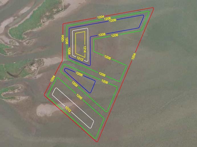
14 Characteristics of ESH Bare Sand: Provides ideal nesting habitat preferred by birds Inter-channel: dynamic environment Wetted Perimeter: Habitat for insects, the food source of Piping Plovers River Mile 770, 73 acres, Constructed Winter 2005 Emergent Sandbar Habitat Program
15 Characteristics of ESH - Continued Nesting Habitat: Should be at least 3 acres, the ideal being roughly 10 acres. Located high and dry on the U/S side of individual sandbars. Area should be relatively level with small undulations 0.5 to 1.5 in height. Well draining particles ranging in size from fine sand to stones < 1 in. in diameter Foraging/Brood Rearing Habitat: Area should be approximately three times larger than the nesting habitat Must be connected to the nesting habitat Slopes to water should be 1:25 and not exceed 1:10. Emergent Sandbar Habitat Program

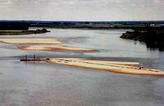
16 Various Methods in Creating ESH Create sandbars from off-channel or in-channel materials Vegetation removal with or without reshaping sandbars -Mechanical or chemical Create sandbars in reservoirs Emergent Sandbar Habitat Program

17 ESH Project Locations Emergent Sandbar Habitat Program


18 ESH and Floodplain Restoration First explored during construction of the Ponca Project Use dredged material from backwaters, side channels to build upon submerged bars Benefits: Fish Habitat Tern forage areas Adds sediment, nutrients to the river Backwater / ESH Restoration - Ponca State Park, NE Emergent Sandbar Habitat Program

19 ESH constructed using material in the river River Mile 761.4, Constructed Fall 2004 Emergent Sandbar Habitat Program

20 ESH constructed using material in the river Main Channel has been along the Nebraska side for many years Missouri River River Mile 760, ,000cfs, Constructed Fall 2004 Emergent Sandbar Habitat Program


21 ESH constructed using material in the river Main Channel has been along the South Dakota side for many years Missouri River River Mile 777, 74 25,000 cfs, currently under construction Emergent Sandbar Habitat Program


22 Reservoir Habitat Shorelines used by plovers when the reservoirs are down Some island creation projects Provides increased longevity compared in-channel sites Cultural Resource Protection, Recreation Benefits Fish Gut Island, Lake Oahe Sedimentation Delta, Lewis and Clark Lake Emergent Sandbar Habitat Program

23 Lewis & Clark Lake


24 Off-channel areas Could provide off-channel ESH habitat in an area not overly beneficial to wildlife or for recreation Increased longevity

25 Bazile Creek WMA Multiple Benefits: Sandbar Habitat Deep water areas for fish over wintering Increased access for noxious weed control Increased connection to the river Recreation opportunities


26 2008 ESH Projects River Mile 848


27 2008 ESH Projects River Mile 842


28 2008 ESH Projects River Mile 838


29 2008 ESH Projects River Mile 795

30 ESH Site Nest Locations Yellow Boxes Piping Plovers Red Triangles Least Terns Emergent Sandbar Habitat Program

31 ESH Site Nest Locations Yellow Boxes Piping Plovers Red Triangles - Terns Emergent Sandbar Habitat Program
32 The Future Continue to build different types of projects and apply lessons learned Work with partner agencies and identify projects with multiple benefits Missouri River at the Chief Standing Bear Memorial Bridge, River Mile 841 Emergent Sandbar Habitat Program


33 Questions? Emergent Sandbar Habitat Program
Cat Island Chain Restoration
 Cat Island Chain Restoration 1820s Fox River Military Road Map to Fort Howard 1845 Chart of Green Bay & Fox River Cat Island Chain - 1938 Cat Island Brown County Aerial Photography, 1938 Historic Western
of Nebraska - Lincoln
 University of Nebraska - Lincoln DigitalCommons@University of Nebraska - Lincoln US Army Corps of Engineers U.S. Department of Defense 2007 Biological Opinion on the Operation of the Missouri River Main
Restoring the Kootenai: A Tribal Approach to Restoration of a Large River in Idaho
 Restoring the Kootenai: A Tribal Approach to Restoration of a Large River in Idaho Susan Ireland, Kootenai Tribe of Idaho Future of our Salmon Conference Technical Session August 2016 Healthy Floodplains,
Missouri River Recovery Program: Integrated Science Program General Science Questions & Key Findings
 University of Nebraska - Lincoln DigitalCommons@University of Nebraska - Lincoln US Army Corps of Engineers U.S. Department of Defense 2010 Missouri River Recovery Program: Integrated Science Program General
Frequently Asked Questions About Revised Critical Habitat and Economic Analysis for the Endangered Arroyo Toad
 Q Frequently Asked Questions About Revised Critical Habitat and Economic Analysis for the Endangered Arroyo Toad Q. What is the arroyo toad? The arroyo toad (Bufo californicus) is a small, light greenish-grey
Restoring America s Greatest River: Collaborative Efforts Along The Lower Mississippi
 Restoring America s Greatest River: Collaborative Efforts Along The Lower Mississippi Angeline J. Rodgers, USFWS/LMRCC K. Jack Killgore, USACE/ERDC Paul Hartfield, USFWS CEER July 31, 2014 Photo: Jan Hoover
Pallid Sturgeon. Pallid sturgeon. Life history
 Pallid Sturgeon Pallid Sturgeon: biology & techniques for monitoring a large river fish Actinopterygii (ray finned fishes) Acipenseriformes (Sturg. & paddlefishes) Acipenseridae (Sturgeons) Scaphirhynchinae
Kootenai River Habitat Restoration Program. Kootenai Tribe of Idaho - January 27, 2014 Presentation for Kootenai Valley Resource Initiative
 Kootenai River Habitat Restoration Program Kootenai Tribe of Idaho - January 27, 2014 Presentation for Kootenai Valley Resource Initiative Decline of native species Kootenai River White Sturgeon ENDANGERED
MISSISSIPPI MAKEOVER A Plan for Restoration, Just Around the Bend
 MISSISSIPPI MAKEOVER A Plan for Restoration, Just Around the Bend Interim Report Card 2013 Project coordinated by the Dakota County Soil and Water Conservation District and sponsored by the Minnesota Pollution
Searsville Dam Removal
 Searsville Dam Removal A unique opportunity for all Presented by the Beyond Searsville Dam Coalition San Francisquito Creek flows into the San Francisco Bay near the Palo Alto Airport and Golf Course seen
MEMORANDUM. July 2, Council members. Tony Grover, Fish and Wildlife Division Director SUBJECT:
 Bill Bradbury Chair Oregon Henry Lorenzen Oregon W. Bill Booth Idaho James A. Yost Idaho Jennifer Anders Vice Chair Montana Pat Smith Montana Tom Karier Washington Phil Rockefeller Washington July 2, 2013
ST. LOUIS SECTION PROJECT OF THE YEAR AWARD
 ST. LOUIS SECTION PROJECT OF THE YEAR AWARD Originality and Innovation The St. Louis Harbor Project is located in the Upper Mississippi River between the entrance to the Chain of Rocks Canal at River
RESILIENCE THROUGH RESTORATION
 RESILIENCE THROUGH RESTORATION RECLAMATION DISTRICT NO. 1601 TWITCHELL ISLAND SAN JOAQUIN RIVER SETBACK LEVEE PROJECT TWITCHELL ISLAND BASICS Nearly 12 miles of levee Storm drainage facilities Protects
CLAIBORNE LOCK AND DAM PERTINENT DATA
 CLAIBORNE LOCK AND DAM PERTINENT DATA GENERAL Location Clarke, Monroe, & Wilcox Counties, Alabama; Alabama River, river mile 72.5 Drainage area Millers Ferry to Claiborne sq. mi. 836 Total drainage area
Rhode Island Department of Environmental Management Division of Fish and Wildlife American Shad Habitat Plan for the Pawcatuck River
 Rhode Island Department of Environmental Management Division of Fish and Wildlife American Shad Habitat Plan for the Pawcatuck River Prepared by: Phil Edwards, Rhode Island Department of Environmental
Friends of the Detroit River Habitat Restoration Project Update
 Friends of the Detroit River Habitat Restoration Project Update 11 Beneficial Use Impairments (BUIs) were originally identified to be associated with the Detroit River: 1. Restrictions on fish and wildlife
STRUCTURE S-65 PURPOSE SPILLWAY OPERATION
 STRUCTURE S-65 This structure is a reinforced concrete, gated spillway with discharge controlled by three cable operated, vertical lift gates, and a reinforced concrete lock structure with two pairs of
[FWS R6 ES 2015 N103; FXES FF06E00000] Endangered and Threatened Wildlife and Plants; Recovery Permit Applications
![[FWS R6 ES 2015 N103; FXES FF06E00000] Endangered and Threatened Wildlife and Plants; Recovery Permit Applications](/thumbs/95/124888860.jpg "[FWS R6 ES 2015 N103; FXES FF06E00000] Endangered and Threatened Wildlife and Plants; Recovery Permit Applications") This document is scheduled to be published in the Federal Register on 06/25/2015 and available online at http://federalregister.gov/a/2015-15606, and on FDsys.gov Billing Code 4310 55 DEPARTMENT OF THE
This document is scheduled to be published in the Federal Register on 06/25/2015 and available online at http://federalregister.gov/a/2015-15606, and on FDsys.gov Billing Code 4310 55 DEPARTMENT OF THE
Endangered Species on Ranches. Nebraska Grazing Conference August 14 15, 2012
 Endangered Species on Ranches Nebraska Grazing Conference August 14 15, 2012 Nature There is a delight in the hard life of the open. There are no words that can tell the hidden spirit of the wilderness
Illinois Lake Management Association Conference March 23, 2018 By Trent Thomas Illinois Department of Natural Resources Division of Fisheries
 Illinois Lake Management Association Conference March 23, 2018 By Trent Thomas Illinois Department of Natural Resources Division of Fisheries Sources of Habitat Impairment Sedimentation Channelization
BIOLOGICAL ASSESSMENT MISSOURI NATIONAL RECREATIONAL RIVER
 University of Nebraska - Lincoln DigitalCommons@University of Nebraska - Lincoln US Army Corps of Engineers U.S. Department of Defense 1992 BIOLOGICAL ASSESSMENT MISSOURI NATIONAL RECREATIONAL RIVER Follow
VIDEO AUDIO Slide 1. Slide 2 Old timey 18 th century map of east coast
 VIDEO AUDIO Slide 1 1A Welcome to the Cooper River Rediversion Project at St. Stephen, Montage of exteriors of facility, South Carolina! Since 1985, this boating, fish runs, fishing, facility has served
X.B WETLANDS ROGUE RIVER ESTUARY
 X.B WETLANDS ROGUE RIVER ESTUARY The Rogue River has a drainage area of 5,100 square miles, yet the estuary of the Rogue River is one of the smallest in Oregon, measuring approximately 1,880 acres during
USING A LABYRINTH WEIR TO INCREASE HYDRAULIC CAPACITY. Dustin Mortensen, P.E. 1 Jake Eckersley, P.E. 1
 USING A LABYRINTH WEIR TO INCREASE HYDRAULIC CAPACITY Dustin Mortensen, P.E. 1 Jake Eckersley, P.E. 1 Plum Creek Floodwater Retarding Structure No. 6 is located in an area of Kyle, Texas, that is currently
Water Resources Report RKLD Annual Meeting July 30, 2016
 Water Resources Report RKLD Annual Meeting 2016 July 30, 2016 Topics Hydrology Report Indianford Dam trash rack cleanout performance Experimental Project update Review of PAS project Twin floods- 1 to
United States Department of the Interior
 United States Department of the Interior FISH AND WILDLIFE SERVICE Virginia Ecological Services Field Office 6669 SHORT LANE GLOUCESTER, VA 23061 PHONE: (804)693-6694 FAX: (804)693-9032 URL: www.fws.gov/northeast/virginiafield/
MCCAW REACH RESTORATION
 Final Report MCCAW REACH FISH RESTORATION PHASE B Jack McCaw Inland Empire Action Coalition http://www.wwccd.net/ Phone: 509-956-3777 Hours: 8:00-4:30 Walla Walla County Conservation District Snake River
FACT SHEET MCGREGOR LAKE RESTORATION HABITAT PROJECT POOL 10, UPPER MISSISSIPPI RIVER, WISCONSIN ENVIRONMENTAL MANAGEMENT PROGRAM
 FACT SHEET MCGREGOR LAKE RESTORATION HABITAT PROJECT POOL 10, UPPER MISSISSIPPI RIVER, WISCONSIN ENVIRONMENTAL MANAGEMENT PROGRAM LOCATION McGregor Lake is located within a mid-river island in Pool 10
UTAH RECLAMATION MITIGATION AND CONSERVATION COMMISSION [RC0ZCUPCA0, 155R0680R1, RR ]
![UTAH RECLAMATION MITIGATION AND CONSERVATION COMMISSION [RC0ZCUPCA0, 155R0680R1, RR ]](/thumbs/86/94483046.jpg "UTAH RECLAMATION MITIGATION AND CONSERVATION COMMISSION [RC0ZCUPCA0, 155R0680R1, RR ]") This document is scheduled to be published in the Federal Register on 07/07/2015 and available online at http://federalregister.gov/a/2015-16600, and on FDsys.gov DEPARTMENT OF THE INTERIOR UTAH RECLAMATION
This document is scheduled to be published in the Federal Register on 07/07/2015 and available online at http://federalregister.gov/a/2015-16600, and on FDsys.gov DEPARTMENT OF THE INTERIOR UTAH RECLAMATION
Flowering Rush An Invasive Aquatic Macrophyte Infesting the Columbia River Basin
 Flowering Rush An Invasive Aquatic Macrophyte Infesting the Columbia River Basin Virgil Dupuis Salish Kootenai College Peter Rice University of Montana Pacific Northwest Distribution Montana Distribution
Blue River Restoration Project William D. Linfield, P.E.
 Blue River Restoration Project William D. Linfield, P.E. 1 2 3 4 5 Blue River Restoration Project BUILDING BRIDGES BETWEEN COMMUNITIES IN COOPERATION WITH THE NATIONAL FOREST FOUNDATION Building Bridges
Suitable Applications Check dams may be appropriate in the following situations: To promote sedimentation behind the dam.
 Categories EC Erosion Control SE Sediment Control TC Tracking Control WE Wind Erosion Control Non-Stormwater NS Management Control Waste Management and WM Materials Pollution Control Legend: Primary Category
Enclosure 9. Memorandum for Record, meeting with FWS on August 12, 2002
 Enclosure 9 Memorandum for Record, meeting with FWS on August 12, 2002 CESAM-PD-EI Brandt/690-3260/23 August 2002 MEMORANDUM FOR RECORD SUBJECT: Meeting with USFWS and FWCC to Discuss ACF Water Control
Warm-up # 7 A day 5/17 - B day 5/18 UPDATE YOUR TABLE OF CONTENTS
 Warm-up # 7 A day 5/17 - B day 5/18 UPDATE YOUR TABLE OF CONTENTS Question: List all examples of surface water on Earth. Answer: Rivers and streams, lakes and reservoirs, (ponds) wetlands, estuaries and
Estimated on-the-ground start and end dates: 1 June October 2018
 A. Applicant Information Name of Organization: U.S. Army Corps of Engineers, Carlyle Lake 801 Lake Road, Carlyle, IL 62231 Contact Information: Robert Wilkins, Operations Manager, (618) 594-2484, Robert.Wilkins@usace.army.mil
United States Department of the Interior
 United States Department of the Interior FISH AND WILDLIFE SERVICE Virginia Ecological Services Field Office 6669 SHORT LANE GLOUCESTER, VA 23061 PHONE: (804)693-6694 FAX: (804)693-9032 URL: www.fws.gov/northeast/virginiafield/
United States Department of the Interior
 United States Department of the Interior John Kennelly, Chief Planning Branch Department of the Army New England District U.S. Army Corps of Engineers 696 Virginia Rd Concord, Massachusetts 01742 FISH
HABITAT RESTORATION USING DREDGED MATERIAL PLACEMENT
 HABITAT RESTORATION USING DREDGED MATERIAL PLACEMENT WITHIN THE LOWER COLUMBIA RIVER AT WOODLAND ISLANDS, WA 237 237 237 217 217 217 200 200 200 Hans Moritz Matt Fraver Logan Negherbon 255 0 163 131 Mike
FACT SHEET I. LOCATION
 STEAMBOAT ISLAND HABITAT REHABILITATION AND ENHANCEMENT PROJECT (HREP) SCOTT COUNTY, IOWA, UPPER MISSISSIPPI RIVER RESTORATION-ENVIRONMENTAL MANAGEMENT PROGRAM ROCK ISLAND DISTRICT FACT SHEET I. LOCATION
Colusa Basin Drain Watershed Fish Stranding Tour Concept Paper Mike Hendrick and Brycen Swart NMFS
 Colusa Basin Drain Watershed Fish Stranding Tour Concept Paper Mike Hendrick and Brycen Swart NMFS On May 31, 2013 representatives from CDFW, USFWS, and NMFS went on a field tour to look at locations in
Study Update Tailrace Slough Use by Anadromous Salmonids
 Study Update Tailrace Slough Use by Anadromous Salmonids Goals and Objectives Identify what anadromous salmonids use the tailrace slough by: Life Stage (Juvenile, migrating and spawning adults) Timing
NEVADA DEPARTMENT OF WILDLIFE STATEWIDE FISHERIES MANAGEMENT
 NEVADA DEPARTMENT OF WILDLIFE STATEWIDE FISHERIES MANAGEMENT FEDERAL AID JOB PROGRESS REPORTS F-2-52 216 CHIMNEY RESERVOIR WESTERN REGION NEVADA DEPARTMENT OF WILDLIFE, FISHERIES DIVISION JOB PROGRESS
Tuolumne River Gravel Introduction
 Tuolumne River Gravel Introduction 2000 2003 Tuolumne River La Grange Gravel Addition, Phase II Course Sediment Replenishment Program Tuolumne River Salmonid Habitat Improvement Project River Mile 49.9
RLRC COMMUNITIES EAST GRAND FORKS AREA CHARACTER THE RED LAKE RIVER & THE RED RIVER OF THE NORTH CONFLUENCE EAGLE POINT BOAT LAUNCH DESIGN
 AREA CHARACTER THE RED LAKE RIVER & THE RED RIVER OF THE NORTH CONFLUENCE EAGLE POINT BOAT LAUNCH DESIGN DESIGN DETAILS 135 AREA CHARACTER East Grand Forks a city of 7,501 people is located across the
Critical Habitat for Atlantic Sturgeon
 Critical Habitat for Atlantic Sturgeon GARFO Presentation to the Chesapeake Bay Sustainable Fisheries Goal Implementation Team September 22, 2017 Julie Crocker NMFS GAR Protected Resources This Presentation
Assateague Island National Seashore North End Restoration Project Timeline
 Assateague Island National Seashore North End Restoration Project Timeline Date Event Some information provided in the Project Introduction document. Detailed events are available in a timeline compiled
La Quinta Channel Extension Port of Corpus Christi Ingleside, Texas. Mark Coyle
 La Quinta Channel Extension Port of Corpus Christi Ingleside, Texas Mark Coyle Corpus Christi Navigation Channel PCCA La Quinta Expansion Project History Corpus Christi Ship Channel Improvement Projects
CENTRAL PROJECT: PLANNING EVERGLADES CENTRAL EVERGLADES RESTORING THE HEART OF THE EVERGLADES
 CENTRAL EVERGLADES PLANNING PROJECT: PRESENTED BY Gina Paduano Ralph, Ph.D. U.S. Army Corps of Engineers Jacksonville District Guy Carpenter Florida Fish and Wildlife Conservation Commission APRIL 2014
Thanks to Burt Strom, Dick Pearce, and Ed Lombardo, Sr. for their help and information.
 The upper section of the Wood River that runs approximately two miles downstream from the bridge on State Route 165 contains a number of significant pools. Although the river is constantly changing through
natural low-water ' conditionson tamed Mississippi, new life springs, up Vl ' V ' ' - "
 When an experiment mimics natural low-water ' conditionson tjhe tamed Mississippi, new life springs, up in the \ backwaters. Vl ' V ' ' - " y *.»* ' ' ' - ' ' by JASON ABRAHAM Common map turtle Mississippi
Plan B Dam Breach Assessment
 Plan B Dam Breach Assessment Introduction In support of the Local Sponsor permit applications to the states of Minnesota and North Dakota, a dam breach analysis for the Plan B alignment of the Fargo-Moorhead
This is a digital document from the collections of the Wyoming Water Resources Data System (WRDS) Library.
 Library.") This is a digital document from the collections of the Wyoming Water Resources Data System (WRDS) Library. For additional information about this document and the document conversion process, please contact
This is a digital document from the collections of the Wyoming Water Resources Data System (WRDS) Library. For additional information about this document and the document conversion process, please contact
PRE- PROPOSAL FORM - Lewis River Aquatic Fund
 PRE- PROPOSAL FORM - Lewis River Aquatic Fund 1. Applicant organization. USDA Forest Service Gifford Pinchot National Forest 2. Organization purpose Resource management agency 3. Project manager (name,
Redd Dewatering and Juvenile Salmonid Stranding in the Lower Feather River,
 Redd Dewatering and Juvenile Salmonid Stranding in the Lower Feather River, 2005-2006 Interim Report for NOAA Fisheries Prepared by: California Department of Water Resources Division of Environmental Services
Creation of Fish and Wildlife Habitat on the Closed Salmon Harbour Mine in Minto, NB
 Creation of Fish and Wildlife Habitat on the Closed Salmon Harbour Mine in Minto, NB M. Coleman 1, R. Rutherford 2, RA Currie 3 1 NB Power 2 Thaumas Environmental Consultants Ltd 3 RA Currie Ltd. Location
James River National Wildlife Refuge, Prince George County, VA; Final. Comprehensive Conservation Plan and Finding of No Significant Impact for
 This document is scheduled to be published in the Federal Register on 07/09/2015 and available online at http://federalregister.gov/a/2015-16764, and on FDsys.gov Billing Code 4310 55 DEPARTMENT OF THE
PROJECT TO INSTALL LARGE WOOD HABITAT STRUCTURES IN THE CARMEL RIVER USING CALIFORNIA DEPARTMENT OF FISH AND GAME GRANT FUNDS
 PROJECT TO INSTALL LARGE WOOD HABITAT STRUCTURES IN THE CARMEL RIVER USING CALIFORNIA DEPARTMENT OF FISH AND GAME GRANT FUNDS The Monterey Peninsula Water Management District (MPWMD), in cooperation with
Fish at the table and in the river: Nearing a quarter-century in the Upper Colorado River Endangered Fish Recovery Program
 Fish at the table and in the river: Nearing a quarter-century in the Upper Colorado River Endangered Fish Recovery Program Angela Kantola Deputy Program Director Partners State of Colorado State of Utah
SKIATOOK LAKE MANAGEMENT PLAN
 SKIATOOK LAKE MANAGEMENT PLAN Background Skiatook Lake impounds Hominy Creek, 5 miles west of Skiatook in Osage County, Oklahoma (Figure 1). Skiatook Lake covers 10,540 surface acres and was constructed
RESTORING 400 ACRES OF TIDAL MARSH IN THE SNOHOMISH RIVER DELTA
 RESTORING 400 ACRES OF TIDAL MARSH IN THE SNOHOMISH RIVER DELTA Marya Moses, Danny Moses, Neil Moses, and Robert Moses fish on Tulalip Bay, near the mouth of the Snohomish River Estuary. QWULOOLT IS A
Species Conclusions Table
 Conclusions Table Project Name: Chesapeake Landing HOA- Breakwaters (NAO-14-0283) Date: February 25, 2014 /Resource Name Loggerhead sea turtle (Caretta caretta) Conclusion ESA Section 7 / Eagle Act Determination
Cumberland River Flood Preparedness Mapping and Products
 Cumberland River Flood Preparedness Mapping and Products Barry P. Moran, P.E. Hydraulic Engineer Nashville District September 2013 US Army Corps of Engineers BUILDING STRONG Authority: As a result of the
Mountain Columbia Province
 Rolling Provincial Review: Implementation 2001-2003 Province 229 Columbia Basin Fish & Wildlife Authority Province FY 2001-2003 Spending Summaries NPCC Recommendations and BPA Spending by Project Category,
United States Department of the Interior
 United States Department of the Interior FISH AND WILDLIFE SERVICE Virginia Ecological Services Field Office 6669 SHORT LANE GLOUCESTER, VA 23061 PHONE: (804)693-6694 FAX: (804)693-9032 URL: www.fws.gov/northeast/virginiafield/
Outstanding Iowa Waters, Trout Streams & Value to Northeast Iowa
 Outstanding Iowa Waters, Trout Streams & Value to Northeast Iowa Mike Steuck NE District Fisheries Supervisor Karst, WQ & Livestock: Finding a Balance for a Sensitive Geography May 30, 2017 Healthy Rivers,
Biological Assessment Missouri National Recreational River
 University of Nebraska Lincoln DigitalCommons@University of Nebraska Lincoln US Army Corps of Engineers U.S. Department of Defense 1990 Biological Assessment Missouri National Recreational River Follow
Appendix L MEMORANDUM OF AGREEMENT DRAFT
 Draft Definite Project Report with Integrated Environmental Assessment Clarence Cannon National Wildlife Refuge HREP Appendix L DRAFT MEMORANDUM OF AGREEMENT INTENTIONALLY LEFT BLANK Memorandum of Agreement
PRE- PROPOSAL FORM - 1. Applicant organization. USDA Forest Service Gifford Pinchot National Forest & WDFW Region 5
 PRE- PROPOSAL FORM - 1. Applicant organization. USDA Forest Service Gifford Pinchot National Forest & WDFW Region 5 2. Organization purpose USFS-Resource management agency WDFW-Fish and Wildlife management
LIFE HISTORY DIVERSITY AND RESILIENCE
 LIFE HISTORY DIVERSITY AND RESILIENCE SPRING CHINOOK IN THE WILLAMETTE RIVER BASIN Kirk Schroeder Brian Cannon Luke Whitman Paul Olmsted Oregon Department of Fish and Wildlife Corvallis Research Lab Thanks
Mid-Columbia Fisheries Enhancement Group Annual Report Fiscal Year 06: July 1, 2005 June 30, 2006
 Mid-Columbia Fisheries Enhancement Group Annual Report Fiscal Year 06: July 1, 2005 June 30, 2006 Mission Statement The mission of the Mid-Columbia Fisheries Enhancement Group is to restore self-sustaining
Rehabilitation of Grimes Creek, a Stream Impacted in the Past by Bucket-lined Dredge Gold Mining, Boise River Drainage, July 2008 to August 2011.
 Rehabilitation of Grimes Creek, a Stream Impacted in the Past by Bucket-lined Dredge Gold Mining, Boise River Drainage, July 2008 to August 2011. Pam Harrington TU,1020 W. Main Street Suite 440, Boise,
CONTENTS. Introduction Glossary of Reading Terms Unit 1 Review Unit 2 Review Unit 3 Review Unit 4 Review...
 CONTENTS Introduction... 4 UNIT 1 Animals in the News... 5 1 Bring Back the Grizzlies... 6 2 Eagles Back from the Brink... 12 3 Penguins at Risk... 18 4 The Great White Shark... 24 Unit 1 Review... 30
Living Beaches: Integrating The Ecological Function Of Beaches Into Coastal Engineering Projects and Beach Management
 Living Beaches: Integrating The Ecological Function Of Beaches Into Coastal Engineering Projects and Beach Management Melissa Bimbi USFWS SC Field Office Kathy Matthews USFWS Raleigh Field Office January
Climate Change Adaptation and Stream Restoration. Jack Williams;
 Climate Change Adaptation and Stream Restoration Jack Williams; jwilliams@tu.org 1 Goals for this presentation Develop strategies for adapting streams to climate impacts by Thinking like a watershed Understanding
Water in the Deschutes Who needs it?
 Water in the Deschutes Who needs it? Rivers and streams over appropriation and flow alteration. Junior water right holders production agriculture. The Cities long-term supply for growing populations. Climate
POLITICS A MONUMENTAL TASK FOR STREAM RESTORATION: AN EXAMPLE FROM TRAPPER CREEK OREGON
 POLITICS A MONUMENTAL TASK FOR STREAM RESTORATION: AN EXAMPLE FROM TRAPPER CREEK OREGON Bradley S. Houslet and Louis Wasniewski Deschutes National Forest TRAPPER CREEK, OR ODELL LAKE PROJECT OBJECTIVES
Incorporating Geomorphic Processes and Sediment Dynamics into Salmonid Habitat Restoration Design
 Salmonid Restoration Federation 35 th Annual Salmonid Restoration Conference Davis, CA Incorporating Geomorphic Processes and Sediment Dynamics into Salmonid Habitat Restoration Design Concurrent Session:
COA-F17-F-1343 YEAR END REPORT
 DAVE MARSHALL SALMON RESERVE RESTORATION, MAINTENANCE, AND UPGRADES YEAR END REPORT Prepared for: Fish and Wildlife Compensation Program Prepared by: Edith Tobe, RPBio, Executive Director Box 1791, Squamish,
Columbia River Fishery Notice
 Columbia River Fishery Notice Oregon Department of Fish and Wildlife January 29, 2014 Compact Action The Columbia River Compact agencies of Oregon and Washington met today and took the following actions:
Kissimmee River Channelization
 Environmental Restoration ti Update Phil Flood, South Florida Water Management District Presentation Overview Kissimmee River Restoration Everglades Stormwater Treatment Areas Comprehensive Everglades
Pre-Visit Lesson Endangered Species On the Brink of Recovery
 Pre-Visit Lesson Endangered Species On the Brink of Recovery Grade Level: 8-10 Summary: Students will read an article describing how the Endangered Species Act became law and the various components contained
Restoring the Iconicc Lower Cache River
 Restoring the Iconicc Lower Cache River A new chapter holds promise of revitalizing cherished waters and woods The story of conservation in the lower Cache River and surrounding Big Woods of eastern Arkansas
Caro Impoundment, Tuscola County
 Caro Impoundment is a 200 acre impoundment of the Cass River located one mile south of the Village of Caro in Tuscola County. Caro Dam, originally constructed in 1906 for water supply to Michigan Sugar
Interlake Tunnel WRA Board Workshop. August 25, 2014
 Interlake Tunnel WRA Board Workshop August 25, 2014 1 Agenda Introduction Project Description Background Concept of tunnel operations Engineering and analysis performed to date Preliminary modeling results
NEVADA DEPARTMENT OF WILDLIFE STATEWIDE FISHERIES MANAGEMENT
 NEVADA DEPARTMENT OF WILDLIFE STATEWIDE FISHERIES MANAGEMENT FEDERAL AID JOB PROGRESS REPORTS F-20-52 2016 EAST FORK AND MAIN STEM CARSON RIVER WESTERN REGION NEVADA DEPARTMENT OF WILDLIFE, FISHERIES DIVISION
Enclosure 16. Memorandum for Record Informal Consultation Telecon 12 March 2004
 Enclosure 16 Memorandum for Record Informal Consultation Telecon 12 March 2004 MEMORANDUM FOR RECORD 1. On Tuesday, 9 March 2004, the US Army Corps of Engineers, Mobile District, Water Management Section
At Home on the Elbow River. -Ours to share-
 At Home on the Elbow River -Ours to share- Living in the shed You are part of the Elbow River Watershed. The Elbow River and its tributaries drain over 1,200 km² of land. The source of the Elbow River
1.Mill Creek Watershed Summary Description and Land Use
 1.Mill Creek Watershed Summary Description and Land Use Table xxx: Mill Creek Watershed Overview Watershed Size 31,435 acres/49.1 sq miles/ 127.1 sq km Elevation Range 5,594 feet [4,967-10,561] Stream
Hot Topics: Endangered Species Act. Presented by Kirk Maag, Stoel Rives LLP October 2016
 Hot Topics: Endangered Species Act Presented by Kirk Maag, Stoel Rives LLP October 2016 ROADMAP Oregon Spotted Frogs Lesser Prairie Chickens Wolverines 2 Oregon Spotted Frog OREGON SPOTTED FROG DISTRIBUTION
OKANAGAN RIVER RESTORATION INITIATIVE - FAQ
 OKANAGAN RIVER RESTORATION INITIATIVE - FAQ Initiative background: The health of the q awsitk w (Okanagan River) has been severely impacted by the channelization works that occurred in the mid-1950 s.
Wildlife Issues With Oil and Gas Exploration. Peter D. McKone, CWB Senior Project Director
 Wildlife Issues With Oil and Gas Exploration Peter D. McKone, CWB Senior Project Director pmckone@wcgrp.com 817-946-7379 Outline Nationwide Issues Regional Issues Industry Examples General Wildlife Impacts
U.S. Army Corps of Engineers (USACE) P.O. Box 428 Smithville, MO
 P.O. Box 428 Smithville, MO") Applicant Information United States Army Corps of Engineers Kansas City District Principal Contact: Derek Dorsey, Natural Resource Manager U.S. Army Corps of Engineers P.O. Box 428 Smithville, MO 64089
Applicant Information United States Army Corps of Engineers Kansas City District Principal Contact: Derek Dorsey, Natural Resource Manager U.S. Army Corps of Engineers P.O. Box 428 Smithville, MO 64089
NEVADA DEPARTMENT OF WILDLIFE STATEWIDE FISHERIES MANAGEMENT
 NEVADA DEPARTMENT OF WILDLIFE STATEWIDE FISHERIES MANAGEMENT FEDERAL AID JOB PROGRESS REPORTS F-20-48 2012 RYE PATCH RESERVOIR WESTERN REGION NEVADA DEPARTMENT OF WILDLIFE, FISHERIES DIVISION JOB PROGRESS
NEVADA DEPARTMENT OF WILDLIFE STATEWIDE FISHERIES MANAGEMENT
 NEVADA DEPARTMENT OF WILDLIFE STATEWIDE FISHERIES MANAGEMENT FEDERAL AID JOB PROGRESS REPORTS F-20-52 2016 RYE PATCH RESERVOIR WESTERN REGION NEVADA DEPARTMENT OF WILDLIFE, FISHERIES DIVISION ANNUAL PROGRESS
10 is bounded by wetlands between RM 1.8 and 3.1 on the south shore and more are scattered
 The Ozette System The Ozette watershed is made up of several lakes and large streams that combine to a total drainage area of 88.4 square miles. The most significant feature of the Ozette watershed is
Overview of the Trinity River
 Overview of the Trinity River The Trinity River The Trinity River begins in the rugged Trinity Alps in northwestern California. On its journey, it tumbles through steep canyons and meanders through broad
SECTION 41 Table of Contents
 SECTION 41 Table of Contents 41 San Poil Subbasin Inventory of Existing Programs Terrestrial...2 41.1 Current Management Directions...2 41.2 Existing and Imminent Protections...3 41.3 Inventory of Recent
Introduction... 4 Animals in the News Bring Back the Grizzlies Penguins at Risk The Great White Shark Unit Review...
 Introduction... 4 Animals in the News... 5 Bring Back the Grizzlies... 6 2 Eagles Back from the Brink... 12 Penguins at Risk... 18 The Great White Shark... 24 Unit Review... 30 Sports Spectaculars... 31
Adopted Regulation Strategy LWCB Regulation Meeting - March 22, 2010
 Adopted Regulation Strategy LWCB Regulation Meeting - March 22, 2010 The Lake of the Woods Control Board held a Regulation Meeting in Kenora on March 25, 2010 and adopted the following strategy. The strategy
WFC 50 California s Wild Vertebrates Jan. 11, Inland Waters (Lakes and Streams) Lisa Thompson
 Lisa Thompson") Inland Waters: Lakes and Streams WFC 50 11 January 2011 Lisa Thompson Fisheries Extension Specialist Wildlife, Fish, & Conservation Biology Department University of California, Davis Take home messages
Inland Waters: Lakes and Streams WFC 50 11 January 2011 Lisa Thompson Fisheries Extension Specialist Wildlife, Fish, & Conservation Biology Department University of California, Davis Take home messages