ANALYSIS OF SKEENA RIVER TRIBUTARIES DOWNSTREAM FROM THE PROPOSED ENBRIDGE PIPELINE. December 20,
|
|
|
- Bennett Mathews
- 5 years ago
- Views:
Transcription
1 ANALYSIS OF SKEENA RIVER TRIBUTARIES DOWNSTREAM FROM THE PROPOSED ENBRIDGE PIPELINE December 20, 2011 By Jack A. Stanford 1, and Diane C. Whited 1 1 Flathead Lake Biological Station, The University of Montana, Polson, Montana USA (Jack.Stanford@umontana.edu) INTRODUCTION We were contracted by the Northwest Institute for Bioregional Research (Smithers, BC) to use our existing databases to produce a series of maps describing the geomorphology of tributaries of the Skeena River, British Columbia that will be crossed by the proposed Enbridge pipeline. The objective was to develop and map metrics that delineate the areas of the Skeena River and its tributaries most vulnerable to potential pipeline spills associated with the proposed Enbridge corridor to Kitimat, BC. The issue of concern is that bitumen, condensate or other petrochemicals could enter the tributaries at or near pipeline crossings should there be a pipeline breach (Swift et al. 2011). In the case of a spill that enters a river channel, petrochemicals will be transported downstream and contaminate river water and aquatic habitat in relation to: a) the slope of the channel (which determines water velocity), b) the volume of water in the channel, c) the geomorphology of the river and its alluvial aquifers and d) the amount and characteristics of the petrochemicals. In this analysis, we examined the geomorphic character of the river channels downstream of crossings. Our analysis was based on the likely scenario that a spill would result in petrochemicals being carried downstream and distributed in the channels in relation to the geomorphology. Unless completely constrained by bedrock, most rivers are alluvial, meaning that porous bed-sediments underlie the flowing water and compose the river flood plains. High gradient headwater streams or river segments in bedrock constrained canyons may be expected to transport petrochemicals very quickly downstream, whereas aggraded flood plains retard water velocity and increase contact with the bed-sediments as well as the alluvial aquifers contained within the bed-sediments of the channel and its flood plains (see Figure 1). If the river is flooding during a spill, petrochemicals may spread expansively across flood plains and directly contaminate riparian vegetation. In any spill scenario, some portion of the river channel and the alluvial aquifers influenced by influx of surface water will be contaminated. The key point here is that contamination from petrochemical spills in alluvial rivers like the Skeena will occur in 3 spatial dimensions: upstream to downstream, laterally across the channel and its flood plains, and vertically into the alluvial aquifer (Figure 1). The fourth dimension is time; if the spill is of short duration and small volume, the contamination attenuates more rapidly than if the spill is catastrophic and of long duration. Exchange of water and materials in the water in these 4 dimensions is precisely what makes floodplain rivers like the Skeena great salmon producers. Habitat and productivity maximizes in the expansive floodplain reaches, which is not to say that constrained reaches and small tributary streams are not

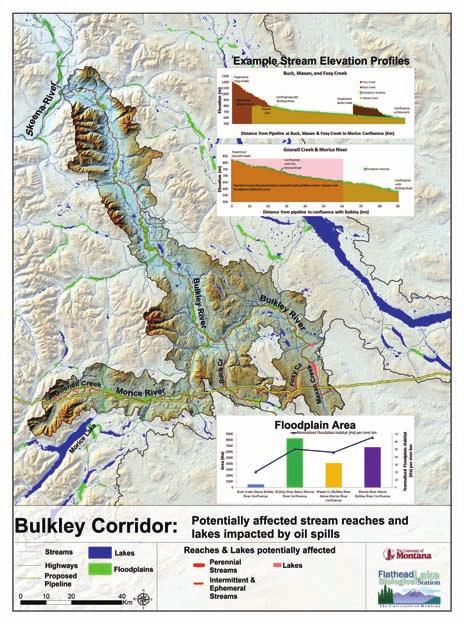
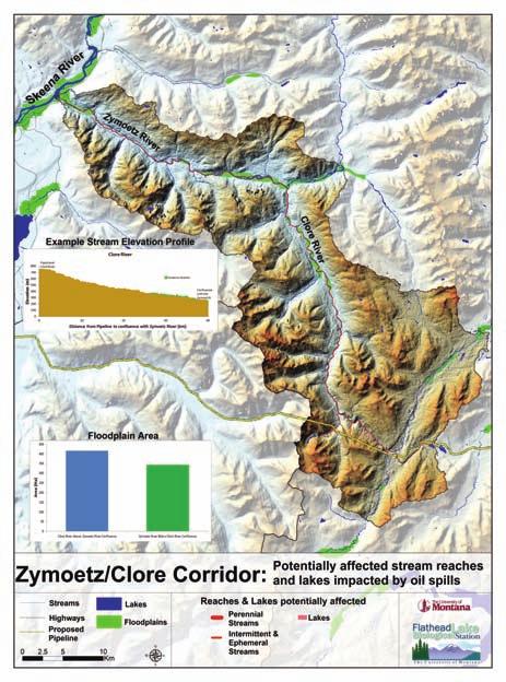
2 important in overall productivity of the river. Although a spill of any magnitude will be toxic regardless of channel morphology for some distance downstream from the spill, the aggraded floodplain reaches are the most vulnerable because these are the areas where the contaminants will attenuate by entraining in the floodplain riparian vegetation, the bed sediments and the alluvial aquifers. The extent of longitudinal, lateral and vertical contamination depends on volume and duration of the spill and the characteristics, such as specific gravity, water solubility, and volatility, of the petrochemicals. But it is a safe bet that a spill of any magnitude will contaminate some portion of the river in all three dimensions over some time period. Hence, we equated vulnerability with floodplain area in this analysis, recognizing, of course, that the most vulnerable reaches are those closest to the spill, regardless of geomorphology. a Headwaters b Headwater Canyon Montane Flood Plain Montane Canyon Piedmont Valley Flood Plain Piedmont Canyon Coastal Flood Plain Delta-Estuary Figure 1. Idealized view of (a) the longitudinal distribution of flood plains and canyons ( beads on a string ) within a river ecosystem from headwaters to the ocean and (b) the 3-D structure of alluvial the flood plains (beads), emphasizing dynamic longitudinal, lateral and vertical dimensions and recruitment of wood debris. The groups of arrows in (a) indicate the expected strength of ground- and surfacewater exchange (vertical), channel and flood plain (lateral) interactions and upstream to downstream or longitudinal (horizontal) connectivity in the context of (b). The floodplain landscape contains a suite of structures produced by the legacy of cut and fill alluviation as influenced by position within the natural-cultural setting of the catchment. The hyporheic zone is defined by penetration of river water into the alluvium and may mix with phreatic ground water from hillslope or other aquifers not directly recharged by the river. Alluvial aquifers usually have complex bed sediments with interstitial zones of preferential groundwater flow (paleochannels). From Stanford et al. (2005). We produced physical metrics that were summarized in 4 maps: a map of the Skeena River catchment showing the proposed pipeline corridor; maps of the Babine, Morice-Bulkley and Clore- Zymoetz corridors. These are the river corridors most likely to be directly affected by 2
3 a pipeline breach. However, a catastrophic spill at or near any of the crossing points could extend through the entire Skeena River system and its estuary. The maps highlight the locations and areas of flood plains where contamination from spills will likely be most pervasive because flood plains and their alluvial aquifers are where river water and materials entrained in the river water is circulated most expansively. Furthermore, these aquatic and riparian habitats determine river biodiversity and productivity and are crucial to successful salmon spawning and rearing. Data sources METHODS The majority of the data used in the analysis were compiled by the Flathead Lake Biological Station within the Riverscape Analysis Project (RAP). RAP data and analysis can be viewed at See Luck et al. (2010) for a detailed description of the database. We used supplemental data from GeoBase Canada ( en/index.html) and Johanna Pfalz at Eclipse GIS to provide detailed base layers for map generation. In addition we downloaded and compiled a 25-m resolution Advanced Spaceborne Thermal Emission and Reflection Radiometer (ASTER) DEM from the National Aeronautics and Space Administration (NASA) Jet Propulsion Laboratory ( /content/03_data/01_data_products/release_dem_relative.htm) to improve our floodplain delineation within the Skeena catchment. Floodplain delineation Flood plains were identified from the Aster 25 m digital elevation model (DEM) using a modified Arc/INFO and Arc Macro Language (AML)/C code program developed by Scott Basset at the University of Nevada, Reno. DEM-derived stream order and elevation information was used to identify flood plains and estimate floodplain areal extent based on lateral distances and maximum elevation thresholds perpendicular to and along the DEM-derived river flow path. For each stream order, buffer distances and maximum elevation thresholds were established to define the corresponding floodplain spatial extent. Buffer distances and maximum elevation thresholds (Table 1) were increased for larger stream order categories to account for larger floodplain areas consistent with larger rivers. Stream elevation profiles We resampled the ASTER 25 m DEM to a coarser 100 m DEM to minimize the elevation variability inherent in the ASTER DEM. We generated stream elevation profiles from this resampled DEM to represent the potential flow paths of petrochemicals and highlighted stream reaches with flood plains and lakes as zones of retention as described above. Although the resampling smoothed out some of the variability within the DEM, some elevation variability remained within the profiles; this variability is expressed as roughness of the profiles. However, the steep versus aggraded (i.e., flat) reaches of the stream profiles were clearly evident. Table 1. Buffers around stream channels were used to set the maximum extent of floodplains during extraction from DEMs. 3
4 Stream Order Elevation (m) Buffer Distance (m) > RESULTS AND DISCUSSION The four maps that we produced are appended to this report, along with a summary table comparing the areas of flood plains in the primary tributaries. Maps should be printed in large format and in color to be most useful. The map of the entire Skeena catchment provides perspective on the distribution of floodplain reaches throughout the system. In general, the headwaters of the system have substantial areas that are low gradient wetlands and small flood plains. The river is very constrained in canyons above and below the Babine confluence, except for lower reaches of the Sustut. The mainstem is mainly confined in canyon reaches until below the Zymoetz confluence near Terrace, BC. From there to the expansive estuary, the mainstem river has broad flood plains with complex channel networks. The Sutherland-Babine, Morice-Bulkley and Clore-Zymoetz corridors were mapped in detail because the pipeline crosses them in the mountainous headwater areas and therefore the points of direct spills into the system would be distributed from these rivers and through their associated flood plains (Table 2). Note that the pipeline is proposed very close to the Gosnell Creek/Morice River for over 60 km. Note also that the Gosnell Creek/Morice River is an expansive floodplain river throughout most of its course and therefore is very vulnerable to spills that could flow into the river anywhere along this 60 km reach. A spill on the Sutherland River could contaminate its floodplain reaches and deliver petrochemicals into Babine Lake. A spill along the tributaries to Helene and Taltapin Lake would greatly impact these lakes, as well as Pinkut Creek (a large sockeye spawning tributary) that drains directly into Babine Lake. A spill on the high gradient Clore system could rapidly move into the flood plains of the Zymoetz and on into the expansive flood plains of the mainstem Skeena. 4
5 Table 2. Comparison of floodplain area and normalized floodplain area per river km for the three potentially affected river reaches. Potentially affected River Reaches Floodplain Area (Ha) Normalized Floodplain area (Ha) per river km Babine Corridor Sutherland River to Babine Lake Above Helene Lake to Babine Lake Above Taltapin Lake to Babine Lake Below Babine Lake to Confluence with Skeena Bulkley Corridor Buck Creek Above Confluence Bulkley River Below Morice River Confluence Maxan Creek/Bulkley River Above Morice River Confluence Gosnell Creek/Morice River Above Bulkley River Confluence Clore/Zymoetz Corridor Clore River Above Zymoetz River Confluence Zymoetz River Below Clore River Confluence Compared with adjacent river systems, the Skeena has a fairly large ratio of flood plains to total catchment area (Figure 2). The Nass and Fraser rivers are very constrained by narrow canyons throughout the catchments. The Stikine has very expansive flood plains in its lower reach; and, even though it also has dramatic canyons, the ratio is quite high (Figure 2). Nonetheless, all four river systems have very high physical complexity values (Table 3). The intent of this comparison is simply to underscore the point that the Skeena s abundant and expansive flood plains operate with the on-channel lakes, notably Babine Lake, to provide a complex array of habitats that drive system biodiversity and productivity, especially for salmon, steelhead, and resident fishes and their food webs. Table 3. Summary of RAP metrics that describe physical complexity of the Skeena River in comparison to adjacent river systems. The term, nodes, refers to channel junctions or places where channels separate or converge. Number of Main Channel Nodes Number of Tributary Nodes Tributary Nodes per river km Nodes per FP river km Nodes per river km Skeena Fraser Nass Stikine
6 Petrochemical spills are problematic for any river system but the impact may be expected to intensify if the rivers are broadly three-dimensional, as is the Skeena. The tributaries crossed by the proposed pipeline are especially vulnerable in this regard. All are well known to function as primary spawning and rearing areas for Skeena fisheries. Indeed, within the Babine catchment, five stream reaches and lake bodies are vulnerable and would be affected by a pipeline spill or rupture. The Babine drainage is the largest tributary to Skeena River and supports diverse stocks of chinook, pink, sockeye, coho, and steelhead salmon. The freshwater fish community is composed of rainbow and cutthroat trout, Dolly Varden, bull trout, and lake char, kokanee, lake and mountain whitefish, lamprey, burbot, sculpins, suckers, and shiners (Gottesfeld and Rabnett 2008). A potential spill from Kilometer Post (KP) 851 to 869 would flow into the Sutherland River and from KP 881 to into the Pinkut Creek system. The Sutherland River supports sockeye salmon and kokanee spawning, as well as spawning, rearing, and holding habitat for coho, steelhead, and rainbow trout. Sutherland River rainbow trout are a singular race of large late-maturing trout, contributing 66% of the rainbow trout found in Babine Lake (Bustard 1990). Pinkut Creek system supports sockeye, coho, and pink salmon spawning, as well as burbot, kokanee, lake trout, lake whitefish, and rainbow trout spawning and rearing. Pinkut Creek is the second most productive salmon tributary to the Babine basin, and over the last 20 years, along with the adjacent spawning channel, has seen an annual average return of 211,165 sockeye spawners (Gottesfeld and Rabnett 2008). Fish values in the Bulkley basin are rated very high due to anadromous coho, sockeye, pink, and chinook salmon, as well as steelhead and Pacific lamprey. Dolly Varden, rainbow trout, and mountain whitefish are present in most fish bearing waters, and bull trout, lake trout, burbot, and a coarse fish community utilize various habitat types in the Bulkley upstream of Morice as well as the Morice system (Gottesfeld and Rabnett 2008). The proposed pipeline crosses through 119 km of the Bulkley drainage, which includes 34 km paralleling the gravel bed Reach 2 of Morice River, which is of high fisheries value (Bustard and Schell 2002). The pipeline is proposed to cross 12 km within the Zymoetz (Copper) River upstream of the Clore Canyon. This generally high elevation area supports bull trout, Dolly Varden, and rainbow trout (Bustard 1996). Downstream of Clore Canyon, the Copper supports coho, chinook, sockeye, pink, chum, steelhead, and a suite of freshwater residents (Gottesfeld and Rabnett 2008). CONCLUSIONS The portion of the Skeena catchment along the proposed pipeline route that was examined in this analysis has an abundance of complex, productive floodplain habitat that is very important for the persistence and production of resident and anadromous fishes. Unfortunately, the characteristics of floodplain habitat that make it productive for fisheries also makes it highly susceptible to impacts from a pipeline breach. Therefore, our conclusions are that a pipeline breach could have severely negative impacts on resident and anadromous fishes. Additionally, all the anadromous fish in the Babine, Bulkley, and Zymoetz systems have already been impacted by 130 years of relatively high exploitation rates due to coastal mixed- 6
7 stock fisheries. As well, all anadromous and freshwater resident fish have had varying degrees of habitat modification due to development activities, including linear perturbations such as railroad, highways, transmission and pipeline corridors, agriculture, urbanization, forestry, and mining, with particular impacts to the productive floodplain habitats. An oil spill or rupture from the proposed pipeline would have significant environmental effects within and beyond the Skeena River system. LITERATURE CITED Bustard, D Sutherland River rainbow trout radio telemetry studies Prepared by Dave Bustard and Associates for British Columbia Ministry of Environment, Smithers, BC. Bustard, D Fisheries assessment of the lower Clore River and tributaries preliminary report. Prepared for Skeena cellulose Inc. Terrace, BC. Bustard, D. and C. Schell Conserving Morice Watershed fish populations and their habitat. Prepared for CFDC Nadina. Gottesfeld, A.S. and K.A. Rabnett Skeena River fish and their habitat. Skeena Fisheries Commission. Hazelton, BC. Luck, M., N. Maumenee, D. Whited, J. Lucotch, S. Chilcote, M. Lorang, D. Goodman, K. McDonald, J. Kimball, and J. Stanford Remote sensing analysis of physical complexity of North Pacific Rim rivers to assist wild salmon conservation. Earth Surface Processes and Landforms 35: Stanford, J. A., M. S. Lorang, and F. R. Hauer The shifting habitat mosaic of river ecosystems. Verh. Internat. Verein. Limnol. 29: Swift, A., N. Lemphers, S. Casey-Lefkowitz, K. Terhune, and D. Droitsch Pipeline and Tanker Trouble. The Impact to British Columbia s Communities, Rivers, and Pacific Coastline from Tar Sands Oil Transport. A Joint Report of the Natural Resources Defense Council, The Pembina Institute, and The Living Oceans Society, New York, 29 pp. 7

8
9
10
11
FISHERIES BLUE MOUNTAINS ADAPTATION PARTNERSHIP
 FISHERIES A warming climate, by itself, substantially affects the hydrology of watersheds in the Blue Mountains. Among the key hydrologic changes projected under all scenarios for the 2040s and beyond
The Calawah River System
 The Calawah River System The Calawah River is the largest tributary of the Bogachiel River and is formed by the confluence of the north and south forks of the Calawah. The two forks of the Calawah, CALAWAH
BULKLEY RIVER ANGLING MANAGEMENT PLAN
 ...-... BHITISH..-..-. COLUMBIA Ministry of Forests, Lands, and Natural Resource Operations BULKLEY RIVER ANGLING MANAGEMENT PLAN This document was published November 19,2013 and endorsed by the Ministry
CHAPTER 4 DESIRED OUTCOMES: VISION, GOALS, AND OBJECTIVES
 CHAPTER 4 DESIRED OUTCOMES: VISION, GOALS, AND OBJECTIVES Vision One of the first steps in developing this Plan was articulating a vision - a clear statement of what the Plan strives to achieve and what
Ecology of Place: What salmon need Eric Beamer Skagit River System Cooperative. November 2010
 Ecology of Place: What salmon need Eric Beamer Skagit River System Cooperative November 2010 Acknowledgements NOAA Fisheries NW Fisheries Science Center Tim Beechie George Pess Correigh Greene Talk overview
Five Counties Salmonid Conservation Program - Fish Passage Design Workshop. February 2013
 Program - Aquatic Organisms and Stream Crossings Ecological Connectivity A watershed is a network of channels that drain a common boundary. Channel characteristics formed by interaction of precipitation,
Steelhead Society of BC. Thompson River Watershed Restoration and Enhancement Project #4 Nicola River Bank Stabilization and Enhancement Project
 Steelhead Society of BC Presents: Thompson River Watershed Restoration and Enhancement Project #4 Nicola River Bank Stabilization and Enhancement Project Application for Funding December 2013 1.0 BACKGROUND
Maintaining biodiversity in mixed-stock salmon fisheries in the Skeena watershed
 Maintaining biodiversity in mixed-stock salmon fisheries in the Skeena watershed A 130-year history Chris C. Wood Principle: Mixed-stock transboundary fisheries impose special requirements on management
Salmon and Migratol~Y Trout of the N,anaimo 'River lind Adjacent Streams (Revised 1,973)
") .. '.' ~! ~j-:-t. ~" I. This s~rie~ includes " unpublished preliminary' reports. ana Glatd rec
.. '.' ~! ~j-:-t. ~" I. This s~rie~ includes " unpublished preliminary' reports. ana Glatd rec
Skeena Salmon. Skeena River Basin. Sockeye Escapement ( ) 1. Average number of spawners. Introduction. Total Accessible Stream Length (km)
 1. Average number of spawners. Introduction. Total Accessible Stream Length (km)") Skeena Salmon Skeena River Basin Version., February 204 Sockeye Escapement (99 200) Average number of spawners Introduction This habitat report card was developed by the Pacific Salmon Foundation with
Skeena Salmon Skeena River Basin Version., February 204 Sockeye Escapement (99 200) Average number of spawners Introduction This habitat report card was developed by the Pacific Salmon Foundation with
1 INTRODUCTION AND SUMMARY
 December 10, 2012 Pacific Booker Minerals 1702 1166 Alberni Street Vancouver, British Columbia V6E 3Z3 Erik Tornquist Executive VP and COO Dear Mr. Erik Tornquist: 1 INTRODUCTION AND SUMMARY This letter
MINISTRY OF ENVIRONMENT ENVIRONMENTAL STEWARDSHIP DIVISION FISH AND WILDLIFE BRANCH. Horsefly River Angling Management Plan
 MINISTRY OF ENVIRONMENT ENVIRONMENTAL STEWARDSHIP DIVISION FISH AND WILDLIFE BRANCH Horsefly River Angling Management Plan January 30 th, 2006 Area/Fishery Description The Horsefly River watershed provides
10 is bounded by wetlands between RM 1.8 and 3.1 on the south shore and more are scattered
 The Ozette System The Ozette watershed is made up of several lakes and large streams that combine to a total drainage area of 88.4 square miles. The most significant feature of the Ozette watershed is
Sub-watershed Summaries
 Project Description The Salmon Drift Creek Watershed Council (SDCWC) has focused their efforts in the Salmon River estuary for the past few years. The multifaceted partnership effort is nearing completion
Okanagan Sockeye Reintroduction
 Okanagan Sockeye Reintroduction Backgrounder Elders accounts, and other forms of Traditional Ecological Knowledge (TEK) tell us that many species of salmon once came into the Okanagan Valley and tell us
FISH PASSAGE IMPROVEMENT in California s Watersheds. Assessments & Recommendations by the Fish Passage Forum
 FISH PASSAGE IMPROVEMENT in California s Watersheds Assessments & Recommendations by the Fish Passage Forum FISH PASSAGE IMPROVEMENT in California s Watersheds The mission of the Fish Passage Forum is
San Lorenzo Valley Water District, Watershed Management Plan, Final Version Part I: Existing Conditions Report
 LIST OF FIGURES Figure 1-1. Map of the San Lorenzo River watershed Figure 2-1. The Santa Cruz Mountains Bioregion Figure 2-2. Protected areas within the San Lorenzo River watershed Figure 2-3. Primary
3. The qualification raised by the ISRP is addressed in #2 above and in the work area submittal and review by the ISRP as addressed in #1.
 Please find attached a response from The Confederated Tribes of the Warm Springs Reservation of Oregon (CTWSRO) for Project # 2008-301-00, Habitat Restoration Planning, Design and Implementation within
SALMONID ACTION PLAN FINAL DRAFT
 SALMONID ACTION PLAN FINAL DRAFT Table of Contents 1 Introduction... 2 2 Overview context... 4 2.1 Fish and Fish Habitat in the Shuswap River... 5 2.2 Impacts and Threats... 6 2.3 Limiting factors... 7
Geomorphic Stream Classification A Classification of Natural Rivers, Rosgen, D.L.
 Geomorphic Stream Classification A Classification of Natural Rivers, Rosgen, D.L. Why is Stream Classification Physical stream channel evolution Essential? Similar stream types manifest similar patterns
For next Thurs: Jackson et al Historical overfishing and the recent collapse of coastal ecosystems. Science 293:
 For next Thurs: Jackson et al. 2001. Historical overfishing and the recent collapse of coastal ecosystems. Science 293: 629-637. Resource: means of supplying a want or deficiency, from French resourdre
Study Update Tailrace Slough Use by Anadromous Salmonids
 Study Update Tailrace Slough Use by Anadromous Salmonids Goals and Objectives Identify what anadromous salmonids use the tailrace slough by: Life Stage (Juvenile, migrating and spawning adults) Timing
STEELHEAD SURVEYS IN OMAK CREEK
 STEELHEAD SURVEYS IN OMAK CREEK 2002 Annual Report Prepared by Chris Fisher John Arterburn Colville Confederated Tribes Fish and Wildlife Department P.O. Box 150 Nespelem, WA 99155 Prepared for Project
OKANAGAN RIVER RESTORATION INITIATIVE - FAQ
 OKANAGAN RIVER RESTORATION INITIATIVE - FAQ Initiative background: The health of the q awsitk w (Okanagan River) has been severely impacted by the channelization works that occurred in the mid-1950 s.
Appendix A Recommended EPA Temperature Thresholds for use in Establishing Thermal Potential and Species Life Stage Numeric Criteria
 Appendix A Recommended EPA Temperature Thresholds for use in Establishing Thermal Potential and Species Life Stage Numeric Criteria 1. Temperature Limits Recommended to Protect Salmonid Guilds In this
Identifying Areas with Potential to Contain High Value Fish Habitat (HVFH) June 2007
 June 2007") Identifying Areas with Potential to Contain High Value Fish Habitat (HVFH) June 2007 1 High Value Fish Habitat INTENT: To apply added precautionary protection to those special areas deemed of high value
Identifying Areas with Potential to Contain High Value Fish Habitat (HVFH) June 2007 1 High Value Fish Habitat INTENT: To apply added precautionary protection to those special areas deemed of high value
COA-F17-F-1343 YEAR END REPORT
 DAVE MARSHALL SALMON RESERVE RESTORATION, MAINTENANCE, AND UPGRADES YEAR END REPORT Prepared for: Fish and Wildlife Compensation Program Prepared by: Edith Tobe, RPBio, Executive Director Box 1791, Squamish,
SALMON FACTS. Chinook Salmon. Oncorhynchus tshawytscha
 SALMON FACTS Chinook Salmon Oncorhynchus tshawytscha Other names: king, tyee, blackmouth (immature) Average size: 10-15 lbs, up to 135 lbs Fall spawner; fall, spring, and summer runs Chinook salmon are
Ned Currence, Nooksack Indian Tribe
 Ned Currence, Nooksack Indian Tribe Problem Status Distribution Habitat Hatcheries Harvest 25000 20000 Natural-Origin Spawners 15000 10000 22500 5000 0 Historic catch Spawners (2011-2015) Problem Status
Trout Unlimited Comments on the Scope of Environmental Impact Statement for the Constitution Pipeline Project, Docket No. PF12-9
 October 9, 2012 Kimberly D. Bose, Secretary Federal Energy Regulatory Commission 888 First Street, NE, Room 1A Washington, DC 20426 RE: Trout Unlimited Comments on the Scope of Environmental Impact Statement
UNIT 4E. SALMON SUPPLEMENTAL INFORMATION
 UNIT 4E. SALMON SUPPLEMENTAL INFORMATION In the STUDENT HANDOUTS/TEACHER PAGES Section of this unit, we have provided you with a host of information from various sources to supplement not only this unit,
Benchmark Statement Respecting the Fish, Fish Habitat and Fisheries of Fish and Little Fish Lake, within the Taseko River Watershed.
 Benchmark Statement Respecting the Fish, Fish Habitat and Fisheries of Fish and Little Fish Lake, within the Taseko River Watershed. Information Supporting the Environmental Assessment of the Prosperity
Recreating Sustainable Fisheries in the Skeena Watershed
 Recreating Sustainable Fisheries in the Skeena Watershed Greg Taylor SkeenaWild Conservation Trust Skeena Watershed Selective Harvesters Association Skeena Fisheries Commission Skeena Sockeye Conservation
Kispiox River Steelhead: Summary of Current Data and Status Review, James S. Baxter 1
 Kispiox River Steelhead: Summary of Current Data and Status Review, 1997 James S. Baxter 1 British Columbia Ministry of Environment, Lands, and Parks Fisheries Branch Skeena Region Box 5000 Smithers, B.C.
The Salmonid Species. The Salmonid Species. Definitions of Salmonid Clans. The Salmonid Species
 The Salmonid Species The Salmonid Species N. American salmon (2 more Asian species) Chinook ( King ) Coho ( Silver ) Sockeye Chum ( Dog ) Pink ( Humpy ) Sea-run trout Steelhead, Cutthroat, Dolly Varden
Climate Change Adaptation and Stream Restoration. Jack Williams;
 Climate Change Adaptation and Stream Restoration Jack Williams; jwilliams@tu.org 1 Goals for this presentation Develop strategies for adapting streams to climate impacts by Thinking like a watershed Understanding
ZYMOETZ RIVER STEELHEAD TROUT: A PRELIMINARY REPORT OF THE 1978 SPORT FISHERY AND SOME ASPECTS OF THEIR LIFE HISTORY. W.E. Chudyk
 ZYMOETZ RIVER STEELHEAD TROUT: A PRELIMINARY REPORT OF THE 1978 SPORT FISHERY AND SOME ASPECTS OF THEIR LIFE HISTORY By W.E. Chudyk P/FR/SK/22 CHUDYK, W. E. ZYMOETZ RIVER STEELHEAD TROUT: A PRELIMINARY
Steelhead Stock Status Review British Columbia
 Steelhead Stock Status Review British Columbia Mark Beere - Senior Fisheries Biologist Skeena Region BC Ministry of Forests, Lands and Natural Resource Operations Overview 1. Stocks and Ecotypes in BC
Restoring the Kootenai: A Tribal Approach to Restoration of a Large River in Idaho
 Restoring the Kootenai: A Tribal Approach to Restoration of a Large River in Idaho Susan Ireland, Kootenai Tribe of Idaho Future of our Salmon Conference Technical Session August 2016 Healthy Floodplains,
Abundance of Steelhead and Coho Salmon in the Lagunitas Creek Drainage, Marin County, California
 scanned for KRIS Abundance of Steelhead and Coho Salmon in the Lagunitas Creek Drainage, Marin County, California Prepared for: Marin Municipal Water District 220 Nellen Drive Corte Madera, California
Skeena Salmon. Skeena Estuary. Estuary location. Introduction. Narrative. Total estuary area 1,802 km 2. Total Accessible Stream Length (km)
") Skeena Salmon Skeena Estuary Version 1.2, February 2014 Introduction This habitat report card was developed by the Pacific Salmon Foundation with technical support from ESSA Technologies. This project
Skeena Salmon Skeena Estuary Version 1.2, February 2014 Introduction This habitat report card was developed by the Pacific Salmon Foundation with technical support from ESSA Technologies. This project
Executive Summary. Map 1. The Santa Clara River watershed with topography.
 Santa Clara River Steelhead Trout: Assessment and Recovery Opportunities December 2005 Prepared By: Matt Stoecker and Elise Kelley, Ph.D. University of California, Santa Barbara Prepared For: The Santa
The Salmon Circle of Life
 The Salmon Circle of Life for millions of years the wild salmon has helped nourish the plant and animal life of the temperate rain forest. Born in the streams and rivers of the forest, the salmon travels
STREAM SURVEY File form No..
 scanned for KRIS THE RESOURCES AGENCY OF CALIFORNIA California Department of Fish and Game STREAM SURVEY File form No.. Date: September 4, 1969. NAME: North Fork Schooner Gulch Creek COUNTY: Mendocino.
WFC 50 California s Wild Vertebrates Jan. 11, Inland Waters (Lakes and Streams) Lisa Thompson
 Lisa Thompson") Inland Waters: Lakes and Streams WFC 50 11 January 2011 Lisa Thompson Fisheries Extension Specialist Wildlife, Fish, & Conservation Biology Department University of California, Davis Take home messages
Inland Waters: Lakes and Streams WFC 50 11 January 2011 Lisa Thompson Fisheries Extension Specialist Wildlife, Fish, & Conservation Biology Department University of California, Davis Take home messages
SALMONID ACTION PLAN FINAL DRAFT DRAFT
 SALMONID ACTION PLAN FINAL DRAFT DRAFT Table of Contents 1. Introduction... 3 2. Overview context... 5 2.1 Salmonids in the Bridge-Seton System... 6 2.2 Impacts and Threats... 7 2.3 Limiting factors...
Minnesota Department of Natural Resources Division of Fish and Wildlife Section of Fisheries. Stream Survey Report. Luxemburg Creek.
 Minnesota F-29-R(P)-24 Area 315 Study 3 March 2016 Minnesota Department of Natural Resources Division of Fish and Wildlife Section of Fisheries Stream Survey Report Luxemburg Creek 2015 Mark Pelham Sauk
Proposed 2018 Fisheries Management Measures to Support Recovery of Interior Fraser River Steelhead
 Proposed 2018 Fisheries Management Measures to Support Recovery of Interior Fraser River Steelhead 22-March-2018 Spawning escapements of two Interior Fraser River steelhead stocks, Thompson and Chilcotin
Searsville Dam Removal
 Searsville Dam Removal A unique opportunity for all Presented by the Beyond Searsville Dam Coalition San Francisquito Creek flows into the San Francisco Bay near the Palo Alto Airport and Golf Course seen
Chadbourne Dam Repair and Fish Barrier
 Chadbourne Dam Repair and Fish Barrier Final Report for the Western Native Trout Initiative Prepared by: Carol Endicott Yellowstone Cutthroat Trout Conservation Biologist Montana Fish, Wildlife & Parks
FINAL REPORT. Yonkers Creek Migration Barrier Removal Project Wonderstump Road Del Norte County. Submitted By:
 FINAL REPORT Yonkers Creek Migration Barrier Removal Project Wonderstump Road Del Norte County Submitted By: Del Norte County Community Development Department Yonkers Creek Migration Barrier Removal Project
Study Update Fish Distribution and Species Composition
 Study Update Fish Distribution and Species Composition Goals and Study Area Gain a better understanding of fish species composition and abundance in waters associated with the Packwood Lake Hydroelectric
Warner Lakes Redband Trout
 Warner Lakes Redband Trout Existing Populations Warner Valley is an endorheic basin that contains a complex series of interconnected lakes, marshes, sloughs, and potholes, all of which are remnants of
Rehabilitation of Grimes Creek, a Stream Impacted in the Past by Bucket-lined Dredge Gold Mining, Boise River Drainage, July 2008 to August 2011.
 Rehabilitation of Grimes Creek, a Stream Impacted in the Past by Bucket-lined Dredge Gold Mining, Boise River Drainage, July 2008 to August 2011. Pam Harrington TU,1020 W. Main Street Suite 440, Boise,
WRIA 20 Inventory and Characterization Report (ICR)
") WRIA 20 Inventory and Characterization Report (ICR) Prepared by Miranda Wecker and Rebekah Gentry UW Olympic Natural Resources Center Revised June 6, 2011 Table of Contents Introduction Introduction...
WRIA 20 Inventory and Characterization Report (ICR) Prepared by Miranda Wecker and Rebekah Gentry UW Olympic Natural Resources Center Revised June 6, 2011 Table of Contents Introduction Introduction...
The Role of the NPAFC in Conservation and Protection of Pacific Salmon
 The Role of the NPAFC in Conservation and Protection of Pacific Salmon Vladimir Fedorenko Executive Director and Shigehiko Urawa Deputy Director North Pacific Anadromous Fish Commission Vancouver, Canada
Project Completion Abstract Fish Passage Activity ( Engineering Activities)
") Project Completion Abstract Fish Passage Activity ( Engineering Activities) SUBMIT COMPLETED FORM TO DISTRICT MANAGER AND FIA ADMINISTRATOR AFTER PROJECT COMPLETION SECTION A GENERAL INFORMATION Recipient:
Project Completion Abstract Fish Passage Activity ( Engineering Activities) SUBMIT COMPLETED FORM TO DISTRICT MANAGER AND FIA ADMINISTRATOR AFTER PROJECT COMPLETION SECTION A GENERAL INFORMATION Recipient:
2012 Bring Back the Natives Awarded Projects
 2012 Bring Back the Natives Awarded Projects EZG # Organization Project Title Project Description Location Description Total Award Amount Grantee Non- Federal Match 31904 Sanctuary Forest, Inc. Mattole
Shovelnose Creek Off-Channel Complex Berm Repair
 Shovelnose Creek Off-Channel Complex Berm Repair Recent high discharge events have put valuable off-channel salmonid rearing and spawning habitat at risk in the upper Squamish River. This document is a
DOWNLOAD OR READ : TROUT STREAMS OF WESTERN NEW YORK PDF EBOOK EPUB MOBI
 DOWNLOAD OR READ : TROUT STREAMS OF WESTERN NEW YORK PDF EBOOK EPUB MOBI Page 1 Page 2 trout streams of western new york trout streams of western pdf trout streams of western new york Interior Redband
Alberta Conservation Association 2017/18 Project Summary Report
 Alberta Conservation Association 2017/18 Project Summary Report Project Name: Abundance, Distribution, Spawning, and Thermal Habitat of Westslope Cutthroat Trout and Bull Trout in the Stimson Creek Watershed
Cold-transitional Small River
 Cold-transitional Small River A Brief Ecological Description of this Michigan River Type Cold-transitional Small River segments are defined (by the Michigan Department of Natural Resources, Fisheries Division)
Managing for Diversity
 Managing for Diversity Pacific Salmon Treaty Workshop: Stanford University, 15 November 2007 John D. Reynolds Tom Buell BC Leadership Chair in Salmon Conservation Department of Biology Simon Fraser University,
Ministry of Environment Response to Working Group Recommendations for Skeena Angling Management Plans. Skeena Quality Waters Strategy April 23, 2010
 Ministry of Environment Response to Working Group Recommendations for Skeena Angling Management Plans Skeena Quality Waters Strategy April 23, 2010 Table of Contents 1.0 Skeena Quality Waters Strategy...
Alberta Conservation Association 2009/10 Project Summary Report. Project Name: North Saskatchewan and Ram Rivers Bull Trout Spawning Stock Assessment
 Alberta Conservation Association 2009/10 Project Summary Report Project Name: North Saskatchewan and Ram Rivers Bull Trout Spawning Stock Assessment Fisheries Program Manager: Peter Aku Project Leader:
Phase 1 Habitat Assessments
 Phase 1 Habitat Assessments CONOR GIORGI ANADROMOUS PROGRAM MANAGER, SPOKANE TRIBE CASEY BALDWIN SENIOR RESEARCH SCIENTIST, COLVILLE CONFEDERATED TRIBES CONTRIBUTIONS FROM: CCT, CDAT, STI, UCUT, & WDFW
2016 Fraser River Stock Assessment and Fishery Summary Chinook, Coho and Chum
 2016 Fraser River Stock Assessment and Fishery Summary Chinook, Coho and Chum 1 Background and Stock Assessment 2 Fraser River Chinook - Background Diverse group of populations exhibit a wide range of
Faith in Nature: The Missing Element in Salmon Management and Mitigation Programs
 Faith in Nature: The Missing Element in Salmon Management and Mitigation Programs Dr. Richard N. Williams Research Associate Department of Biology The College of Idaho -- and -- Jim Lichatowich Alder Fork
1.Mill Creek Watershed Summary Description and Land Use
 1.Mill Creek Watershed Summary Description and Land Use Table xxx: Mill Creek Watershed Overview Watershed Size 31,435 acres/49.1 sq miles/ 127.1 sq km Elevation Range 5,594 feet [4,967-10,561] Stream
Hatcheries: Role in Restoration and Enhancement of Salmon Populations
 Hatcheries: Role in Restoration and Enhancement of Salmon Populations Hatcheries play a large role in the management, ecology, and evolution of Pacific salmon. Why were/are they built? What are the assumptions
Interim Guidance Fish Presence Absence
 Interim Guidance Fish Presence Absence Source: Forest Practices Act Guidance for Division 635 of the forest practices act dealing with stream classification when no fish surveys have been done (referenced
Amendment to a Biological Assessment/Evaluation completed for the Coon Creek Land Disposal completed December Grand Valley Ranger District
 Amendment to a Biological Assessment/Evaluation completed for the Coon Creek Land Disposal completed December 2007 Grand Valley Ranger District Grand Mesa, Uncompahgre, Gunnison National Forests Prepared
"Recommended Improvements for the Next Pacific Salmon Treaty"
 "Recommended Improvements for the Next Pacific Salmon Treaty" Randall M. Peterman School of Resource and Environmental Management Simon Fraser University Burnaby, British Columbia, Canada Web site: http://www.rem.sfu.ca/fishgrp/
Fish Tech Weekly Outline January 14-18
 Fish Tech Weekly Outline January 14-18 TOPICS: salmon, trout, and char in Southeast Alaska salmonid identification overview salmonid life cycle and stages salmonid freshwater and marine distribution/residence
Salmon Escapement to Englishman River, 2005
 Salmon Escapement to Englishman River, 2005 Ian Matthews and Alan Eden 1 South Coast Area Fisheries and Oceans Canada 3225 Stephenson Point Road Nanaimo, BC V9T 1K3 March 2005 1 365 Dunsmuir Rd, Qualicum
Tributary Assessment for Potential Chinook Salmon Rearing Habitat and Recommendations for Prioritizing Habitat Protection and Restoration
 Tributary Assessment for Potential Chinook Salmon Rearing Habitat and Recommendations for Prioritizing Habitat Protection and Restoration Ed Connor and Erin Lowery, Seattle City Light Devin Smith and Kate
STUDY PERFORMANCE REPORT
 STUDY PERFORMANCE REPORT State: Michigan Project No.: F-80-R-4 Study No.: 702 Title: Effects of sediment traps on Michigan river channels Period Covered: October 1, 2002 to September 30, 2003 Study Objectives:
Incorporating Geomorphic Processes and Sediment Dynamics into Salmonid Habitat Restoration Design
 Salmonid Restoration Federation 35 th Annual Salmonid Restoration Conference Davis, CA Incorporating Geomorphic Processes and Sediment Dynamics into Salmonid Habitat Restoration Design Concurrent Session:
A.23 RIVER LAMPREY (LAMPETRA
 A. RIVER LAMPREY (LAMPETRA AYRESII) A.. Legal and Other Status The river lamprey is a Class (Watch List) California Species of Special Concern (Moyle et al., DFG 0). It has no federal status. A.. Species
Statement of Dr. Jack Williams Senior Scientist, Trout Unlimited. Before the
 Statement of Dr. Jack Williams Senior Scientist, Trout Unlimited Before the Subcommittee of Water and Power Energy and Natural Resources Committee United States Senate June 6, 2007 Mr. Chairman, Members
Chinook Salmon. The Yukon River Panel
 Chinook Salmon and The Yukon River Panel Jan Conitz, ADF&G UAF FISH 493 Discussion January 26, 2016 Discussion Outline I. Yukon River context Salmon and Yukon River basics Fishing and history on the Yukon
GEOMORPHIC AND RIPARIAN INFLUENCES ON THE DISTRIBUTION AND ABUNDANCE OF SALMONIDS IN A CASCADE MOUNTAIN STREAM 1
 GEOMORPHIC AND RIPARIAN INFLUENCES ON THE DISTRIBUTION AND ABUNDANCE OF SALMONIDS IN A CASCADE MOUNTAIN STREAM 1 Kelly M. S. Moore and Stan V. Gregory 2 Abstract: Abundance of resident cutthroat (Salmo
Lakelse Sockeye Recovery Program
 Lakelse Sockeye Recovery Program The Ninth Annual BC Interior Stewardship Workshop May 7 th and 8 th, 2013 DFO North Coast Resource Restoration Unit Presentation Overview History/background Stock and habitat
Of the Salmon and For the Salmon
 Of the Salmon and For the Salmon for millions of years the wild salmon has helped nourish the plant and animal life of the temperate rain forest. Born in the streams and rivers of the forest, the salmon
Backgrounder and Frequently Asked Questions
 Backgrounder and Frequently Asked Questions Who Sent the Letter? The 60-day Notice of Intent to File Suit was sent by Conservation Angler, Wild Fish Conservancy, Snake River Waterkeeper, Friends of the
Mountain Snake Province
 Rolling Provincial Review: Implementation 2001-2003 Province 253 Columbia Basin Fish & Wildlife Authority Province FY 2001-2003 Spending Summaries NPCC Recommendations and BPA Spending by Project Category,
Mid-Columbia Fisheries Enhancement Group Annual Report Fiscal Year 06: July 1, 2005 June 30, 2006
 Mid-Columbia Fisheries Enhancement Group Annual Report Fiscal Year 06: July 1, 2005 June 30, 2006 Mission Statement The mission of the Mid-Columbia Fisheries Enhancement Group is to restore self-sustaining
Data Report : Russian River Basin Steelhead and Coho Salmon Monitoring Program Pilot Study
 Data Report 1999-1: Russian River Basin Steelhead and Coho Salmon Monitoring Program Pilot Study Sonoma County Water Agency 215 West College Avenue Santa Rosa, California 951 Prepared by David Cook Senior
MCCAW REACH RESTORATION
 Final Report MCCAW REACH FISH RESTORATION PHASE B Jack McCaw Inland Empire Action Coalition http://www.wwccd.net/ Phone: 509-956-3777 Hours: 8:00-4:30 Walla Walla County Conservation District Snake River
MEMORANDUM. Ron Boyce, ODFW Bob Heinith, CRITFC. Michele DeHart. DATE: November 30, Operations
 FISH PASSAGE CENTER 1827 NE 44 th Ave., Suite 240, Portland, OR 97213 Phone: (503) 230-4099 Fax: (503) 230-7559 http://www.fpc.org/ e-mail us at fpcstaff@fpc.org MEMORANDUM TO: Ron Boyce, ODFW Bob Heinith,
Redd Dewatering and Juvenile Salmonid Stranding in the Lower Feather River,
 Redd Dewatering and Juvenile Salmonid Stranding in the Lower Feather River, 2005-2006 Interim Report for NOAA Fisheries Prepared by: California Department of Water Resources Division of Environmental Services
Cheakamus River IR 11 Floodplain Restoration Final Report Project Number 13.CMS.01
 Cheakamus River IR 11 Floodplain Restoration Final Report Project Number 13.CMS.01 Prepared by: Squamish River Watershed Society Box 1791 Squamish, B.C. V08B 0B3 With financial support of: BC Hydro Fish
Annual Report for Fiscal Year and Future Plans for the Tillamook Bay Watershed Council
 Annual Report for Fiscal Year 2012-2013 and Future Plans for the Tillamook Bay Watershed Council A report prepared for the Tillamook County Board of Commissioners August 2013 Table of Contents: Recently
Kenai River Sockeye Escapement Goals. United Cook Inlet Drift Association
 Kenai River Sockeye Escapement Goals United Cook Inlet Drift Association 2014 Evaluating Sockeye Escapement Goals in the Kenai River Utilizing Brood Tables and Markov Tables This presentation pertains
Ministry of Forests, Lands, and Natural Resource Operations OVERVIEW OF ANGLING MANAGEMENT PLANS FOR THE SKEENA WATERSHED
 Ministry of Forests, Lands, and Natural Resource Operations OVERVIEW OF ANGLING MANAGEMENT PLANS FOR THE SKEENA WATERSHED November 19, 2013 1.0 Intent of this Document This overview provides background
Southern Oregon Coastal Cutthroat Trout
 Species Management Unit Description Southern Oregon Coastal Cutthroat Trout The Southern Oregon Coastal Cutthroat Trout SMU includes all populations of cutthroat trout inhabiting ocean tributary streams
Aquatic Organism Passage at Road-Stream Crossings CHUCK KEEPORTS FOREST HYDROLOGIST ALLEGHENY NATIONAL FOREST WARREN, PENNSYLVANIA
 Aquatic Organism Passage at Road-Stream Crossings CHUCK KEEPORTS FOREST HYDROLOGIST ALLEGHENY NATIONAL FOREST WARREN, PENNSYLVANIA TOPICS COVERED Aquatic Organism Passage (AOP) Benefits of AOP Crossings
Study 9.5 Fish Distribution and Abundance in the Upper Susitna River
 Initial Study Report Meeting Study 9.5 Fish Distribution and Abundance in the Upper Susitna River October 15, 2014 Prepared by R2 Resource Consultants, Inc. 10/15/2014 1 Study 9.5 Objectives 1. Describe
P/FR/SK/54 DE LEEUW, A. D. MAMIN RIVER STEELMEAD: A STUDY ON A LIMITED TAGGING CPOX c. 1 mm SMITHERS MAMIN RIVER STEELHEAD: A STUDY ON A LIMITED
 P/FR/SK/54 DE LEEUW, A. D. MAMIN RIVER STEELMEAD: A STUDY ON A LIMITED TAGGING CPOX c. 1 mm SMITHERS MAMIN RIVER STEELHEAD: A STUDY ON A LIMITED TAGGING STUDY UNDERTAKEN DURING WINTER, 1984 by A.D. de
Fish Habitat Restoration and Monitoring in Southeast Washington. Andy Hill Eco Logical Research, Inc.
 Fish Habitat Restoration and Monitoring in Southeast Washington Andy Hill Eco Logical Research, Inc. Fish Habitat Restoration and Monitoring in Southeast Washington Talk overview: Restoration projects