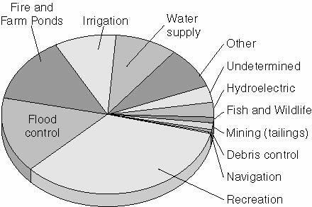
Dams: costs/benefits. Positive. Negative. economic growth food production surface water enhancement recreation enhancement
|
|
|
- Andrea Brooks
- 5 years ago
- Views:
Transcription
1 Dams
2 Dams: costs/benefits Positive economic growth food production surface water enhancement recreation enhancement Negative loss of wildlife habitat destruction of river corridors displaced peoples methyl mercury
3
4

5 F07_03 PRINCIPAL PARTS OF A DAM

6 CLASSIFICATION OF PRINCIPAL STORAGE ZONES IN A CROSS SECTION OF A MULTI-PURPOSE RESERVOUR F07_05
 form a staircase of")

7 F07_14 River dams (locks, levees) form a staircase of reservoirs that stretch the entire length of the Tennessee River
8
9
10 Ratio of the present value of project benefits to the present value of the costs Benefits and costs assigned a dollar value (yr accrued) Develop a ratio (I.e. 2:1) Ration better than 1:1 means positive ratio Determine the present value of the following costs of dam construction. Consider Year 1 as the present year. All values are in the thousands, and the interest is 8% simple interest compounded annually. Year 1 Year 2 Year 3 TOTAL $ $ $ $ The present value cost of Year 1 = $ The present value cost of Year 2 = $ divided by 1.08% = $ ($ invested 8% simple interest for one year = $ ) The present cost of Year 3 = $ divided twice by 1.08% = $ (This means that $ invested at 8% simple interest will be worth $ after two years) Therefore, the present value cost of $ in this example is $ $ $ $ = $

11 Impacts of Dams Farther downstream, the opposite can occur with silt forming islands and sandbars. Dams change behaviour of rivers- sediment load settles behind a dam. Downstream, water released through outlet pipes causes channel erosion
12 Hydroelectricity And The James Bay Project The Quiet Revolution Resulted in Four Major Events: Resurgence of ethnic nationalism (Quebecois) Quebec s joining the urban/industrial world of North America and expansion in the size of its industrial labour force and business class Removal of the old elite State s aggressive role in the province s affairs

13 Hydroelectric Power in Quebec strong physical feature i. heavy annual precipitation ii. high elevations of Can. Shield Huge hydroelectric plants Technology

14 The James Bay Project

15 The James Bay and Northern Quebec Agreement

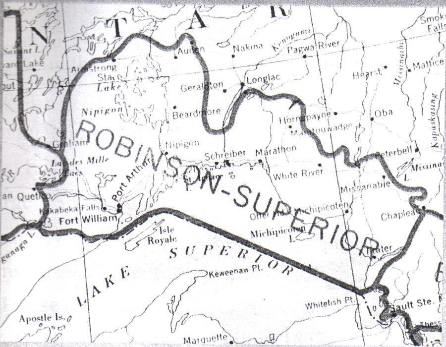
16 The Nipigon River

17 The Nipigon Basin


 1940 Ogoki river diversion begins.")
18 History of the Area Aboriginals are well established in the area Ojibway sign the Robinson Superior Treaty 1900s First log drive attempted down the Nipigon river. Full log drives occurred from WW1 Commercial fishing begins. Construction of hydro dams begin along the Nipigon R. Hydro dams were constructed until the 1950s Europeans arrive and are in awe at the limitless supply of beavers, otters and muskrats. Became huge center for fur trade. Late 1800s The Nipigon Region begins to be identified as a beautiful area internationally. CPR is built through Nipigon. The region is now connected to the rest of the country World Record Brook Trout Caught (14.5 lbs) 1940 Ogoki river diversion begins. Increased flow of Nipigon R. by 50% 2001 Nipigon places a special focus on sustaining bald eagle population in area. Theodore Roosevelt
19 Long Lake and Ogoki Diversions
20 Purpose of the Project To ease fears that energy shortages in the United States would hinder industrial production of material for the World War II defense effort. a) Long Lake Diversion To move water from the Albany River in the James Bay drainage system into the Great Lakes. To redirect Kenogami River flows south into the Aguasabon River that empties into Lake Superior. Its two functions: - Interbasin pulpwood transportation - Power generation in the St. Mary s, Niagara and St. Lawrence rivers b) Ogoki Diversion To divert northeastward flowing Ogoki River southward through Lake Nipigon and into the Great Lakes system. To provide an average 113 m 3 /s flow increment of water for power production at generating stations on the Nipigon, St. Mary s, Niagara and St. Lawrence rivers.
21 History of the projects In 1940, the United States agreed to use 143 m 3 /s of water at Niagara Falls in Ontario, if Canada would rapidly construct the Ogoki and Long Lake diversions.
22 The Process Ogoki Diversion Construction of a diversion dam at Waboose Rapids. Caused water levels at Ogoki River to rise 12 m. Flooded the river valley and Mojikit Lake up to the height of the land. There, a 0.4 km diversion channel was excavated. The Summit Control Dam constructed to regulate southerly flows. The diverted water enlarges the Little Jackfish River which discharges into Ombabika Bay at the north end of Lake Nipigon. Trees were not cleared from the reservoir prior to inundation. The project became operational in July 1943.
23

24 Summit Dam

25 Waboose Dam

26 Diversion Effects
27 Biophysical Change Erosion in Reservoirs, Diversion Channels & Receiving Water Bodies - Erosion has led to... Increased turbidity Degraded water quality Damaged private property & cultural artifacts * Impaired habitats for fish
28 Biophysical Change Trees are in or near reservoirs, Diversion Channels and Lake Nipigon Failure to clear trees has led to... Excess debris (Will take 100s of years to disappear by natural oxidation) Partially submerged standing trees Causes navigation & shoreline access hazards. Degraded natural aesthetic beauty.
29 Biophysical Change Drowned vegetation - Creates a hazard for commercial fishing - Long term impact on fish habitats is unclear - Still an abundant population of walleye and pike in Ogoki Reservoir - Mercury levels in fish flesh are above acceptable levels for consumption - No evidence of detrimental effects on moose, caribou or other animals living in the diverted watershed.
30 Socioeconomic Change Economic Benefits from Hydroelectricity of Long Lake & Ogoki Diversions to 1974 profits exceeded 220 million dollars.
31 Socioeconomic Change Credit for Diverted Water - Canada s right to the diverted water was made permanent by the 1950 Niagara River Treaty to 1972 diversions averaged 18.7 m 3 /s more than expected. - Under the treaty, Canada can use only half of the surplus (9.3 m3 /s). - The United States agreed in principal that the rights of water diverted into the Great Lakes should be vested in the country from whose territory it comes. - This agreement was not approved by the U.S. Senate. - Canada does not receive credit for about 9.3 m3 /s of water at Niagara and for half of the diverted water in the St. Mary s and St. Lawrence rivers. (The result of failing to create an international Great Lakes Basin water agreement)
32 Source
33 Cultural Conflicts History of the Aboriginals Robinson-Superior Treaty Conflicts
34 History The Aboriginals The aboriginals have been situated in the Nipigon region as early as 8000 BCE. They were nomadic hunters and gatherers and they solely relied on fish, wildlife, plants, small and big game in the area.
35 The Aboriginals (cont.) Robinson-Superior Treaty Treaty signed in the Nipigon region, September 7, 1850 Prepared by Crown and Ojibway Indians near Superior Purpose was for the Crown to remove minerals and other items of value on the land In return the Aboriginals are able to live off the land Created Indian reserves The crown will assist the Aboriginals if there are land claim issues.
36 The Robinson-Superior Treaty
37 Proposed Little Jackfish River Hydroelectric
38 The Aboriginals Present Conflict Conflict between the Whitesand Indian Band and Ontario Hydro concerning the proposed Little Jackfish Hydroelectric Project. Whitesand Indian Band is afraid of the same effect the Ogoki Diversion had on their community. The proposed Little Jackfish Hydroelectric Project has the potential of damaging the river system by flooding and destroying the land.
39 The Aboriginals Actions Taken June 4, 1990, Ontario Hydro and the Chief and Council of the Whitesand Indian band announced a comprehensive land use and harvesting study. Highlights from the study included the economic, social, cultural, and spiritual importance of living off the land. Conflicts between Whitesand Indian Band and Ontario Hydro dealt with in a fair and effective manner. The Little Jackfish River Hydroelectric Project has not started construction.
40 Hydro-Electric Dams and Their Effect on Fish Populations

41 Problems Associated with the Damming of the Nipigon River Brief history of the hydro-electric dams Problems with water level fluctuations Effects on fish populations

42 Map of Dams
43 Brief History of Dams in the Nipigon Region Cameron Falls Dam 1920 Alexander Dam 1930 Pine Portage Generating Station 1950

44 Problems Associated with Water Level Fluctuations Water level fluctuations necessary to regulate flow to dams Resulted in flooding of surrounding land and lakes Erosion of stream banks and sediment load Negatively affected fish populations: migrating and spawning patterns.

45 Effects of the Dams on Fish Construction of dams has reduced migration and affected spawning Greatest impact on Brook Trout Fluctuating river levels in combination with competition from other introduced fish species, and extensive fishing caused populations to drop significantly 1989 rehabilitation program put into effect Populations are improving since implementation of program.
The Qamanirjuaq Caribou Herd An Arctic Enigma by Leslie Wakelyn
 The Qamanirjuaq Caribou Herd An Arctic Enigma by Leslie Wakelyn Range location and use: Every year for thousands of years, Qamanirjuaq caribou have migrated from calving and post-calving areas on the tundra,
REPORT TO THE MINISTER OF NATURAL RESOURCES. Pursuant to an appointment made by the Honourable Frank S. Miller, Minister of Natural
 Room 569, Fifth Floor, Mowat Block, Queen's Park, Toronto, Ontario. M7A la2 IN THE MATTER OF The Lakes and Rivers Improvement Act; AND IN THE MATTER OF An application by Rudolph Adam for approval under
What was the historic coaster fishery like?
 1 of 6 1/30/2012 12:25 PM Home About Topics Contact Us Fishing Calendar Fish ID Tips FAQs Hack Noyes Research Vessel Is it a unique strain long lost from Wisconsin's shoreline? Fisheries Reports Tributaries
First Nations Fish Habitat Program Discussion Workbook
 First Nations Fish Habitat Program Discussion Workbook The First Nations Fish Habitat Program is a joint initiative of the Centre for Indigenous Environmental Resources (CIER) and The Southern Chiefs Organization
COA-F17-F-1343 YEAR END REPORT
 DAVE MARSHALL SALMON RESERVE RESTORATION, MAINTENANCE, AND UPGRADES YEAR END REPORT Prepared for: Fish and Wildlife Compensation Program Prepared by: Edith Tobe, RPBio, Executive Director Box 1791, Squamish,
Removal of natural obstructions to improve Atlantic Salmon and Brook Trout habitat in western NL. 26/02/2015 Version 2.0
 Removal of natural obstructions to improve Atlantic Salmon and Brook Trout habitat in western NL 26/02/2015 Version 2.0 1 Table of Contents List of Tables... 2 Introduction... 3 Methods... 4 Preliminary
Decommission Springbank Dam
 Decommission Springbank Dam Prepared for: Ontario Rivers Alliance June 13 th, 2015 Presented by: The Thames River Anglers Association Robert Huber (Pres.) Askunassippi (Antler River) The Thames River is
Implementing the New Fisheries Protection Provisions under the Fisheries Act
 Implementing the New Fisheries Protection Provisions under the Fisheries Act Discussion Paper Fisheries and Oceans Canada April 2013 Contents 1. Introduction 2. Managing Threats to Canada s Fisheries 3.
2012 Wildlife Studies
 2012 Wildlife Studies Prepared by Cardno ENTRIX Agency Meeting on Draft 2012 Study Descriptions December 8, 2011 1 Project Components 2 Project Region ADF&G GMUs 3 Wildlife Studies for 2012 W-S1: Wildlife
SITE C CLEAN ENERGY PROJECT
 SITE C CLEAN ENERGY PROJECT VOLUME 5 APPENDIX A04 PART 6 SUPPLEMENTAL TLUS REPORT: DENE THA FIRST NATION FINAL REPORT Prepared for BC Hydro and Power Authority Prepared for the Dene Tha First Nation by
Okanagan Sockeye Reintroduction
 Okanagan Sockeye Reintroduction Backgrounder Elders accounts, and other forms of Traditional Ecological Knowledge (TEK) tell us that many species of salmon once came into the Okanagan Valley and tell us
Fisheries Management Zone 10:
 Fisheries Management Zone 10: Lake Trout Operational Objectives and Management Photo Credit: www.jamessmedleyoutdoors.com 2 FMZ 10: Lake Trout Operational Objectives and Management Lake trout are the second
N ORTHWEST T ERRITORY M ÉTIS N ATION Box 720 Fort Smith, NT Canada X0E 0P0. 1. An Overview of the NWTMN Historical Context
 1. An Overview of the NWTMN Historical Context The Northwest Territory Métis Nation (NWTMN) is comprised of the Indigenous Métis from the South Slave region in the Northwest Territories. The NWTMN is comprised
Black Sturgeon Regional Plan
 Black Sturgeon Regional Plan This is one of twenty Regional Plans that support implementation of the Lake Superior Biodiversity Conservation Strategy (Strategy). The Strategy, prepared and overseen by
Maryland Chapter Trout Unlimited Brook Trout Conservation Effort
 Maryland Chapter Trout Unlimited Brook Trout Conservation Effort Photo by Matt Kline Portfolio of Recent Work MDTU Brook Trout Conservation Coordinator: Scott C. Scarfone, ASLA sscarfone@oasisdesigngroup.com
ATLANTIC STURGEON. Consultations on listing under the Species at Risk Act
 ATLANTIC STURGEON Consultations on listing under the Species at Risk Act Information summary and questionnaire for consultations on adding two Atlantic Sturgeon populations to the List of Wildlife Species
CONNECTICUT RIVER WATERSHED COUNCIL The River Connects Us
 CONNECTICUT RIVER WATERSHED COUNCIL The River Connects Us Upper Valley: P.O. Box 206, Saxtons River, VT 05154 Electronic Filing UNITED STATES OF AMERICA FEDERAL ENERGY REGULATORY COMMISSION Grafton Hydro,
APPENDIX 2.1 Lake Sturgeon - Mitigation and Enhancement
 APPENDIX 2.1 Lake Sturgeon - Mitigation and This page is intentionally left blank. Lake Sturgeon Mitigation and As a provincial crown corporation providing electric energy and natural gas service, Manitoba
AmericAn PlAice. consultations on listing under the Species at Risk Act
 AmericAn PlAice consultations on listing under the Species at Risk Act Photo: D. Danvoye Information summary and questionnaire for the consultations on adding two American Plaice populations to the List
Caroline Desbiens (2004)
") Hydro Caroline Desbiens (2004) For Quebeckers Hydro-Québec is essential As practical, economic reality As symbolism Hydro Electricity Derives from the topography of northern Quebec Shield country with
Hydro Caroline Desbiens (2004) For Quebeckers Hydro-Québec is essential As practical, economic reality As symbolism Hydro Electricity Derives from the topography of northern Quebec Shield country with
A BLUEPRINT FOR THE PENOBSCOT RIVER WATERSHED
 A BLUEPRINT FOR THE PENOBSCOT RIVER WATERSHED About this series 2 # for a healthy Penobscot watershed M aine rivers used to be full of fish swimming upstream from the ocean every year on their spawning
VIDEO AUDIO Slide 1. Slide 2 Old timey 18 th century map of east coast
 VIDEO AUDIO Slide 1 1A Welcome to the Cooper River Rediversion Project at St. Stephen, Montage of exteriors of facility, South Carolina! Since 1985, this boating, fish runs, fishing, facility has served
Management and Control of Asian Carps in the United States. Greg Conover Asian Carp Working Group, Chair USFWS, Carterville FRO
 Management and Control of Asian Carps in the United States Greg Conover Asian Carp Working Group, Chair USFWS, Carterville FRO Asian Carp 7 carps native to Asia introduced into U.S. Asian carps = bighead,
Dauphin Lake Fishery. Status of Walleye Stocks and Conservation Measures
 Dauphin Lake Fishery Status of Walleye Stocks and Conservation Measures Date: December, 21 Dauphin Lake Fishery Status of Walleye Stocks and Conservation Measures Background: Walleye stocks in Dauphin
FISH COMMUNITIES AND FISHERIES OF THE THOUSAND ISLANDS AND MIDDLE CORRIDOR
 St. Lawrence River Discussion Paper FISH COMMUNITIES AND FISHERIES OF THE THOUSAND ISLANDS AND MIDDLE CORRIDOR Issues Below is a synopsis of fish community issues and proposed management approaches. More
Diversion and the Uncertain Future for the. Young Generations. Living Through the Impacts of Churchill River
 Diversion and the Uncertain Future for the Young Generations Living Through the Impacts of Churchill River Overview of Socio -Economic Impacts of Churchill River Diversion-Augmented Flow Program. 1. Economy
Kuujjua River. Introduction. Route Description. Words of Caution. edition 2012
 Kuujjua River Introduction Victoria Island (part of Western Canada's High Arctic island archipelago) is Canada's third-largest island, divided by an administrative line between the Northwest Territories
At Home on the Elbow River. -Ours to share-
 At Home on the Elbow River -Ours to share- Living in the shed You are part of the Elbow River Watershed. The Elbow River and its tributaries drain over 1,200 km² of land. The source of the Elbow River
Fish Community. Fish Habitat, Streams and Rivers
 Clear, Ston(e)y and White Lake Plan Fish Community The lakes support a cool/warm water fishery including muskellunge, walleye, largemouth and smallmouth bass, yellow perch, pumpkinseed, rockbass, blue
Geology. Key Factors. Overfishing. Great Lakes Fishes. Historical Fishing. About 10,000 years since last glacial retreat very young ecologically
 Great Lakes Fishes Geology About 10,000 years since last glacial retreat very young ecologically Largest surface freshwater system on earth 21% of world s supply 84% of North America s supply Five unique
Highlights of Native Fish Rehabilitation Activities in the Great Lakes. Presented By: Arunas Liskauskas, Ontario Ministry of Natural Resources
 Highlights of Native Fish Rehabilitation Activities in the Great Lakes Presented By: Arunas Liskauskas, Ontario Ministry of Natural Resources In this presentation Focus on activities from 2002 to 2007
Naskapi Perspective on Caribou Harvesting
 Naskapi Perspective on Caribou Harvesting Migratory Caribou Workshop Montréal, January 20-22, 2010 Presented by John Mameamskum Director General Naskapi Nation of Kawawachikamach The Naskapis: Brief History
Angling in Manitoba (2000)
") Angling in Manitoba (2000) TABLE OF CONTENTS Page Introduction 1 Angler Profile 2 Angling Effort 7 Catch and Harvest 10 Angling Expenditures 13 Bait Use 16 Nonresident Trip Characteristics 18 Angling in
Angling in Manitoba (2000) TABLE OF CONTENTS Page Introduction 1 Angler Profile 2 Angling Effort 7 Catch and Harvest 10 Angling Expenditures 13 Bait Use 16 Nonresident Trip Characteristics 18 Angling in
UNIT 4E. SALMON SUPPLEMENTAL INFORMATION
 UNIT 4E. SALMON SUPPLEMENTAL INFORMATION In the STUDENT HANDOUTS/TEACHER PAGES Section of this unit, we have provided you with a host of information from various sources to supplement not only this unit,
There are two types of selective commercial fisheries conducted by Talok Fisheries:
 Lake Babine Nation Inland Fishery The inland commercial fishery on Lake Babine is operated by a private fishing company named Talok that is owned by the Lake Babine Nation (LBN). This company is governed
GSS Engineering Consultants Ltd Dam Removal and LRIA Jeff Graham, P. Eng June, 2017
 GSS Engineering Consultants Ltd Dam Removal and LRIA Jeff Graham, P. Eng June, 2017 Below - Lockerby Dam on North Saugeen River - removed August, 2015 Background Jeff Graham is a life long angler stream
Creation of Fish and Wildlife Habitat on the Closed Salmon Harbour Mine in Minto, NB
 Creation of Fish and Wildlife Habitat on the Closed Salmon Harbour Mine in Minto, NB M. Coleman 1, R. Rutherford 2, RA Currie 3 1 NB Power 2 Thaumas Environmental Consultants Ltd 3 RA Currie Ltd. Location
NYS Coastal Waters. Water Resources of NYS: THE NATURE of the COASTAL ZONE. NYS Coastal Waters. NYS Coastal Atlas. Coastal Zone Management 10/10/2014
 Water Resources of NYS: THE NATURE of the COASTAL ZONE NYS Coastal Waters NYS is the only state to border the Atlantic Ocean and the Great Lakes (Lakes Erie and Ontario). Great Lakes shoreline: 577 miles
Mercury in hydroelectric reservoirs Hydro-Québec and the me...
 hydroquebec.com Mercury in hydroelectric reservoirs Hydro-Québec and the mercury issue 6-8 minutes Sources of mercury Mercury is found everywhere in the environment. It is in the air, soil and vegetation,
Go Home Bay Walleye Re-introduction Project
 Eastern Georgian Bay Stewardship Council www.helpourfisheries.com Go Home Bay Walleye Re-introduction Project Eastern Georgian Bay Stewardship Council July 27, 2010 Walleye summer fingerlings planted in
SCIENCE AND TECHNOLOGY: CANADA COAST TO COAST
 ACTIVITY DESCRIPTION: This activity shows the abundance of water in and around Canada. By identifying and labeling a number of water bodies and courses, students realize the magnitude of Canada s water
DALE HOLLOW LAKE TROOPER ISLAND IMPROVEMENT PROJECT Proposal for Reservoir Fisheries Habitat Partnership (RFHP)
") DALE HOLLOW LAKE TROOPER ISLAND IMPROVEMENT PROJECT Proposal for Reservoir Fisheries Habitat Partnership (RFHP) A. Applicant Information: US Army Corps of Engineers, Dale Hollow Lake POC: Gregg Nivens
DALE HOLLOW LAKE TROOPER ISLAND IMPROVEMENT PROJECT Proposal for Reservoir Fisheries Habitat Partnership (RFHP) A. Applicant Information: US Army Corps of Engineers, Dale Hollow Lake POC: Gregg Nivens
This is America: The Potomac River Flows Through Cities, History
 This is America: The Potomac River Flows Through Cities, History Today we tell about the Potomac River. The Potomac is one of America s most historic waterways. It flows more than 600 kilometers, from
Restoring the Kootenai: A Tribal Approach to Restoration of a Large River in Idaho
 Restoring the Kootenai: A Tribal Approach to Restoration of a Large River in Idaho Susan Ireland, Kootenai Tribe of Idaho Future of our Salmon Conference Technical Session August 2016 Healthy Floodplains,
MINNESOTA DEPARTMENT OF NATURAL RESOURCES DIVISION OF FISHERIES AND WILDLIFE. Gamefish Assessment Report
 Minnesota DNR F-29-R(P) Area F312 February 1, 2013 MINNESOTA DEPARTMENT OF NATURAL RESOURCES DIVISION OF FISHERIES AND WILDLIFE Gamefish Assessment Report Spring Gamefish Assessment on the Mississippi
Eastern Georgian Bay Stewardship Council
 Eastern Georgian Bay Stewardship Council Who / What is the Eastern Geo. Bay Stewardship Council? MNR s community, volunteer, environmental program called the Ontario Stewardship Program Supported by but
Site Tour, August 24, Fish Science - Big Lake Coho Salmon Migration and Habitat Use
 Matanuska-Susitna Basin Salmon Habitat Partnership Site Tour, August 24, 2015 Part 1 of Tour Big Lake watershed Fish Science - Big Lake Coho Salmon Migration and Habitat Use Presenter: Jon Gerken (U.S.
Current projects for Fisheries Research Unit of Minnesota Department of Natural Resources
 Current projects for Fisheries Research Unit of Minnesota Department of Natural Resources MAJOR RESOURCE ISSUES IN THE DIVISION OF FISHERIES Status of Fish Populations To effectively manage fish populations,
OVERVIEW OF MID-COLUMBIA FISHERIES ENHANCEMENT GROUP
 Mid-Columbia Fisheries Enhancement Group MISSION STATEMENT The Mid-Columbia Fisheries Enhancement Group is a non-profit organization dedicated to restoring selfsustaining salmon and steelhead populations
Renseignements supplémentaires. Supplementary Information. Présentation du Ministère des Richesses naturelles de l Ontario
 Deep Geologic Repository Joint Commission d examen conjoint du projet de stockage dans des couches géologiques profondes PMD 13-P1.6B File / dossier : 8.01.07 Date: 2013-10-01 Edocs: 4209085 Supplementary
Angling in Manitoba Survey of Recreational Angling
 Angling in Manitoba 2005 Survey of Recreational Angling TABLE OF CONTENTS Page Introduction 1 Angler Profile 2 Angling Effort 6 Catch and Harvest 9 Angling Expenditures 11 Bait Use 14 Canadian and Nonresident
JAP Additional Information Sheet
 JAP Additional Information Sheet Block 15: Purpose and Need The USACE purpose of the project is to provide a safe and reliable whitewater park for the recreational public in a city park, which will provide
RESILIENCE THROUGH RESTORATION
 RESILIENCE THROUGH RESTORATION RECLAMATION DISTRICT NO. 1601 TWITCHELL ISLAND SAN JOAQUIN RIVER SETBACK LEVEE PROJECT TWITCHELL ISLAND BASICS Nearly 12 miles of levee Storm drainage facilities Protects
STEELHEAD SURVEYS IN OMAK CREEK
 STEELHEAD SURVEYS IN OMAK CREEK 2002 Annual Report Prepared by Chris Fisher John Arterburn Colville Confederated Tribes Fish and Wildlife Department P.O. Box 150 Nespelem, WA 99155 Prepared for Project
Searsville Dam Removal
 Searsville Dam Removal A unique opportunity for all Presented by the Beyond Searsville Dam Coalition San Francisquito Creek flows into the San Francisco Bay near the Palo Alto Airport and Golf Course seen
Adopted Regulation Strategy Lake of the Woods Control Board Regulation Meeting March 12, 2013
 Adopted Regulation Strategy Lake of the Woods Control Board Regulation Meeting March 12, 2013 The Lake of the Woods Control Board held a Regulation Meeting March 12, 2013 in Kenora. The strategy was formulated
TRAPLINE VC34 Land Use Before the La Grande Complex
 SUMMARY OF TRAPLINE LAND USE BEFORE THE LA GRANDE PROJECT TRAPLINE VC34 Land Use Before the La Grande Complex Trapline Background Information The trapline VC34 is located at more than 175 km east of Eastmain,
Chinook Salmon. The Yukon River Panel
 Chinook Salmon and The Yukon River Panel Jan Conitz, ADF&G UAF FISH 493 Discussion January 26, 2016 Discussion Outline I. Yukon River context Salmon and Yukon River basics Fishing and history on the Yukon
Huntington District. For More Information Contact (304)
") Zoar Levee & Diversion Dam are located in the Muskingum River Basin highlighted in green to left. The Muskingum River Basin is the site of Ohio s first multiple purpose water management and land conservation
Zoar Levee & Diversion Dam are located in the Muskingum River Basin highlighted in green to left. The Muskingum River Basin is the site of Ohio s first multiple purpose water management and land conservation
The Case of the Disappearing Shoreline
 Name The Case of the Disappearing Shoreline Humans change the earth's climate in many ways. One change is the increase of carbon dioxide in the atmosphere. As we burn more fossil fuels, we release more
Oregon Department of Fish and Wildlife: Inland Fisheries - Hatchery Management
 Oregon Department of Fish and Wildlife: Inland Fisheries - Hatchery Management Primary Outcome Area: Economy & Jobs Secondary Outcome Area: Healthy Environments Program Contact: Ed Bowles, 503-947-6206
Acknowledgements Frank C. Bellrose & Daniel Holm
 Nesting Ducks of Tennessee Wood Ducks, Mallards, Hooded Mergansers Billy Minser UT FWF Acknowledgements Frank C. Bellrose & Daniel Holm Dick McCabe Featuring Frank Bellrose and Scott Neilson 1 There are
Illinois Lake Management Association Conference March 23, 2018 By Trent Thomas Illinois Department of Natural Resources Division of Fisheries
 Illinois Lake Management Association Conference March 23, 2018 By Trent Thomas Illinois Department of Natural Resources Division of Fisheries Sources of Habitat Impairment Sedimentation Channelization
Regulatory Guidelines for Managing the Muskellunge Sport Fishery in Ontario
 Regulatory Guidelines for Managing the Muskellunge Sport Fishery in Ontario Fisheries Section Fish and Wildlife Branch Ontario Ministry of Natural Resources June 2003 Updated August 2005 Regulatory Guidelines
Project Name: Distribution and Abundance of the Migratory Bull Trout Population in the Castle River Drainage (Year 4 of 4)
") Alberta Conservation Association (ACA) Date: 2014-2015 Project Name: Distribution and Abundance of the Migratory Bull Trout Population in the Castle River Drainage (Year 4 of 4) Fisheries Program Manager:
Alberta Conservation Association (ACA) Date: 2014-2015 Project Name: Distribution and Abundance of the Migratory Bull Trout Population in the Castle River Drainage (Year 4 of 4) Fisheries Program Manager:
Impacts of Aquatic Invasive Species on the Lake Superior Fishery. by Jeff Gunderson Minnesota Sea Grant Program
 Impacts of Aquatic Invasive Species on the Lake Superior Fishery by Jeff Gunderson Minnesota Sea Grant Program Can humans really impact the fishery of such a large waterbody? Lake Superior Fishery Change
Know Your River - River Ogmore Salmon and Sea Trout Catchment Summary
 Know Your River - River Ogmore Salmon and Sea Trout Catchment Summary Introduction This report describes the status of the salmon and sea trout populations in the Ogmore catchments. Bringing together data
A New Ecological Framework for Recreational Fisheries Management in Ontario
 A New Ecological Framework for Recreational Fisheries Management in Ontario FOCUS: New Fisheries Management Zones State of the Resource Reporting Enhanced Stewardship Ministry of Natural Resources Ontario's
Ecological gains through EIA in Parks Canada
 Ecological gains through EIA in Parks Canada Eric Tremblay, Park Ecologist, Kouchibouguac National Park, NB, Canada April 6 th, 2017 1 Integrating SARA and Fisheries Act Aboriginal consultations 2 Kouchibouguac
TRAPLINE CH14 (FG14) Land Use Before the La Grande Complex
 Land Use Before the La Grande Complex") SUMMARY OF TRAPLINE LAND USE BEFORE THE LA GRANDE PROJECT TRAPLINE CH14 (FG14) Land Use Before the La Grande Complex Trapline Background Information The trapline CH14 is located about 140 kms east of Chisasibi
SUMMARY OF TRAPLINE LAND USE BEFORE THE LA GRANDE PROJECT TRAPLINE CH14 (FG14) Land Use Before the La Grande Complex Trapline Background Information The trapline CH14 is located about 140 kms east of Chisasibi
Restoration of Spawning Habitat for Native Fish in the Central Great Lakes
 Restoration of Spawning Habitat for Native Fish in the Central Great Lakes D. H. B E N N I O N 1, E. R O S E M A N 1, B. M A N N Y 1, G. K E N N E D Y 1, J. B O A S E 2, J C R A I G 1 1 U S G S - G R E
Design and Installation of two Permanent Booms at La Romaine-2 to resist Ice, retain Debris and serve as Safety Booms.
 CGU HS Committee on River Ice Processes and the Environment 18 th Workshop on the Hydraulics of Ice Covered Rivers Quebec City, QC, Canada, August 18-20, 2015 Design and Installation of two Permanent Booms
Fisheries Resources in White Pine County
 Fisheries Resources in White Pine County June 22, 2013 Update to the Nevada Board of Wildlife Commissioners Jon C. Sjöberg Chief of Fisheries Comins Lake Located 7 miles south of Ely. Built in 1953 as
Fish and Wildlife Compensation Program Trevor Oussoren, program manager, Columbia region. CRT Workshop, Fauquier, June 15, 2013
 Angus Glass Fish and Wildlife Compensation Program Trevor Oussoren, program manager, Columbia region. CRT Workshop, Fauquier, June 15, 2013 The Fish and Wildlife Compensation Program is a partnership of:
Module 2 Narration What is a watershed?
 Module 2 Narration What is a watershed? Timing Key Narrative Snapshots a) 00:10 Every living thing relies on water to exist. But where does our water come from? The most natural place to look is upstream
Kirt Hughes Washington Department of Fish and Wildlife Region 6 - Fish Program Manager
 Kirt Hughes Region 6 - Fish Program Manager Habitat Hatcheries Harvest Clean Water Act Shorelines Harvest Hydro Habitat Forest Practices Non-regulatory Programs Water Supply & Conservation Growth Management
What you do to Eeyou Istchee (our land), you do to Eeyouch (our people)
, you do to Eeyouch (our people)") What you do to Eeyou Istchee (our land), you do to Eeyouch (our people) The Nishiiyuu Council of Elders stands with the Cree Nation in its strong opposition to uranium development in our territory, Eeyou
What you do to Eeyou Istchee (our land), you do to Eeyouch (our people) The Nishiiyuu Council of Elders stands with the Cree Nation in its strong opposition to uranium development in our territory, Eeyou
Emergent Sandbar Habitat Program Middle Missouri River
 Emergent Sandbar Habitat Program Middle Missouri River Jeremiah Szynskie, P.E. Hydrologic Engineering Branch Introduction Main Stem System Dam Closures Fort Peck 1937 Fort Randall 1952 Garrison - 1953
Nechako white sturgeon are an Endangered Species
 Nechako white sturgeon are an Endangered Species There are likely less than 350 Nechako white sturgeon, and historically there were over 5000 in the Nechako Watershed. Endangered as per the Species at
Gayaza High School Geography Department
 THE DEVELOPMENT OF THE SAINT LAWRENCE SEAWAY This is an inland water way partly artificially constructed from the Gulf of St. Lawrence to the Western end of Lake Superior. It covers a distance of 3,800
Frequently Asked Questions About Revised Critical Habitat and Economic Analysis for the Endangered Arroyo Toad
 Q Frequently Asked Questions About Revised Critical Habitat and Economic Analysis for the Endangered Arroyo Toad Q. What is the arroyo toad? The arroyo toad (Bufo californicus) is a small, light greenish-grey
FACT SHEET I. LOCATION
 STEAMBOAT ISLAND HABITAT REHABILITATION AND ENHANCEMENT PROJECT (HREP) SCOTT COUNTY, IOWA, UPPER MISSISSIPPI RIVER RESTORATION-ENVIRONMENTAL MANAGEMENT PROGRAM ROCK ISLAND DISTRICT FACT SHEET I. LOCATION
Wild Virginia and Heartwood first raised this issue at the May 19, 2014 public meeting.
 June 13, 2014 Karen Stevens Pat Sheridan, District Ranger Warm Springs Ranger District 422 Forestry Road Hot Springs, VA 24445 karenlstevens@fs.fed.us psheridan@fs.fed.us re: Lower Cowpasture Restoration
Western native Trout Status report
 Bull trout (Salvelinus confluentus) Data: Draft Recovery Plan, USFWS, 2002; FR Final Critical Habitat Rule - 2005 Partners: ID, MT, OR, WA, NV, FWS, FS, BLM, NPS, Tribes, AK, Canada Species Status review:
Steelhead Sport Fishing Regulations Proposals Vancouver Island Region for April 1, 2007
 Steelhead Sport Fishing Regulations Proposals Vancouver Island Region for April 1, 2007 Sport fishing regulations governing steelhead fishing have changed many times over the past 30 years. Generally the
Proposed Shuswap River Boating Regulations Open House
 Proposed Shuswap River Boating Regulations Open House Welcome, and thank you for attending this Open House regarding proposed boating regulations for the Shuswap River. A partnership of the Regional District
f Agricultural S c i e n c SMALL EARTH DAMS LLOYD N. BROWN ^ CALIFORNIA AGRICULTURAL CIRCULAR 467 \ Experiment Station Extension Service
 f Agricultural S c i e n c SMALL EARTH DAMS LLOYD N. BROWN ^ CALIFORNIA AGRICULTURAL \ Experiment Station Extension Service CIRCULAR 467 Crest of dam Dry face slope 2 to 1 Downstream toe About 10,000 small
SUBJECT: Provision of Fish or Gametes from the Provincial Fish Culture Program
 SECTION: Aquaculture SUBSECTION: Source of Fish or Gametes SUBJECT: Provision of Fish or Gametes from the Provincial Fish Culture Program POLICY/PROCEDURE: FisPp.9.5.1 ISSUE DATE: August 2004 DEFINITIONS
Swift Current Creek Watershed
 Swift Current Creek Watershed Watershed Boundary Gross drainage area 3939 km 2 973,343 acres Gross creek length 230 km 143 miles Primary water source for 20 000 people Major source of water base recreation
Upper/Lower Owl Creek Reservoir
 Upper/Lower Owl Creek Reservoir Schuylkill County 2018 Largemouth Bass Survey Upper Owl Creek Reservoir and Lower Owl Creek Reservoir are 67-acre and 26-acre impoundments, respectively, created by two
5B. Management of invasive species in the Cosumnes and Mokelumne River Basins
 5B. Management of invasive species in the Cosumnes and Mokelumne River Basins Cosumnes River The Cosumnes River basin has a number of distinct habitat types that require different management strategies
Reduction in Biological Diversity Section 4.1 p Section 4.3 p
 Reduction in Biological Diversity Section 4.1 p. 57-65 Section 4.3 p. 72-78 Review Ecological Diversity A variety of ecosystems (mountains, forests, deserts) and how they interact together. Community Diversity
Wisconsin s Fur Trade Impact Definition: Impact on Native people Impact on Environment Impact on Economy
 Wisconsin s Fur Trade Impact Definition: Important early business involving Native people trading beaver, mink, and otter pelts to European traders for blankets, brass cooking pots, metal axes, woolen
Peace River Water Use Plan. Monitoring Program Terms of Reference. GMSMON-1 Peace River Creel Survey
 Peace River Water Use Plan Monitoring Program Terms of Reference GMSMON-1 Peace River Creel Survey April 10, 2008 Terms of Reference for the Peace River Water Use Plan Monitoring Program: Peace River Creel
Section 2: Biodiversity at Risk
 Section 2: Biodiversity at Risk Preview Classroom Catalyst Objectives Biodiversity at Risk Current Extinctions Species Prone to Extinction How Do Humans Cause Extinctions? Habitat Destruction and Fragmentation
Burns Paiute Tribe Fisheries Department. Evaluate The Life History Of Native Salmonids Within The Malheur Subbasin Project #
 Burns Paiute Tribe Fisheries Department Evaluate The Life History Of Native Salmonids Within The Malheur Subbasin Project # 199701900 Prior to 1990 Technical and/or scientific background Malheur population,
Agenda Item 7.1 For Information. Council CNL(10)24. Annual Report on Actions Taken Under Implementation Plans USA
24. Annual Report on Actions Taken Under Implementation Plans USA") Agenda Item 7.1 For Information Council CNL(10)24 Annual Report on Actions Taken Under Implementation Plans USA Annual Report on actions taken under the US Implementation Plan for the Calendar Year 2009
Agenda Item 7.1 For Information Council CNL(10)24 Annual Report on Actions Taken Under Implementation Plans USA Annual Report on actions taken under the US Implementation Plan for the Calendar Year 2009
Site 4 PEESHOO. Approx. Head = 10 m Design Flow = 70 m 3 /s Capacity = 6 MW. Peeshoo. Kabinakagami River. Rogers Road HWY 11.
 Kabinakagami River Site 4 PEESHOO Rogers Road Peeshoo Approx. Head = 10 m Design Flow = 70 m 3 /s Capacity = 6 MW N 0 2 4 6 HWY 11 Kilometers Site 4 - PEESHOO Looking Downstream Looking Downstream Site
Maintaining biodiversity in mixed-stock salmon fisheries in the Skeena watershed
 Maintaining biodiversity in mixed-stock salmon fisheries in the Skeena watershed A 130-year history Chris C. Wood Principle: Mixed-stock transboundary fisheries impose special requirements on management
Western Pocono Chapter. Trout Unlimited. 67 West Butler Drive fc ^
 February 18,2013 Rosemary Chiavetta, Esq. Secretary Western Pocono Chapter Trout Unlimited 67 West Butler Drive fc Drums, PA 18222 3 m "TJ {"H > ro -< c? O Pennsylvania Public Utility Commission P.O.