Environmental Assessment and Finding of No Significant Impact. Interim Risk Reduction Measures Chena River Lakes Project Fairbanks, Alaska
|
|
|
- Gabriel Peter Adams
- 5 years ago
- Views:
Transcription
1


2 Environmental Assessment and Finding of No Significant Impact Interim Risk Reduction Measures Chena River Lakes Project Fairbanks, Alaska January 2010
3 Finding of No Significant Impact Interim Risk Reduction Measures Chena River Lakes Project Fairbanks, Alaska The Alaska District, U.S. Army Corps of Engineers will revise operating procedures, clear vegetation, and modify project structures to reduce risks and consequences of dam failure at the Chena River Lakes Project near Fairbanks, Alaska. These actions are immediate, interim measures in response to a recent nation-wide evaluation of dams and the risks and failure modes that were identified in that evaluation. The Moose Creek Dam, part of the Chena River Lakes Project, reduces flooding risk to Fairbanks and surrounding areas by temporarily storing or diverting floodwaters of the Chena River. The dam impounds water temporarily during high water events. The Chena River runs free through the project during normal flows. Operating procedures will be revised to minimize floodwater retention time and volume without exceeding authorized discharges in Fairbanks or causing undue flooding along the Chena River. The control sill across the project floodway will be lowered to release more impounded water to the Tanana River earlier during high water events. Accumulated silt will be removed from stilling basins at the Moose Creek Dam control works and at the floodway control sill so they function properly and to facilitate inspection. Vegetation, primarily trees and brush, will be cleared so it will not restrict floodwater discharge, so the dam can be inspected and mitigation actions can be taken during high water events, and so the vegetation does not contribute to dam failure risks. Additional interim and permanent measures may follow. The actions addressed in this Finding are necessary now and do not pre-decide additional measures that might be employed later. These actions will commence in the late winter and early spring of They will not substantially impair air quality in the Fairbanks nonattainment area or water quality in the Chena River. Vegetation removal will not affect endangered plant species or plants that are locally uncommon or of particular value. Vegetation clearing would not discharge into waters of the United States, including wetlands. Changes in operation could, under specific and unusual circumstances, delay salmon returns to the upper Chena River. Lowering the sill could increase the occasional release of floodwaters and juvenile fish into the Tanana River. Vegetation clearing would be timed to avoid taking of nesting birds, their eggs, or young. Approximately 100 acres of locally common bird habitat would be substantially modified by the vegetation clearing. The Alaska District, U.S. Army Corps of Engineers will work with resource agencies to monitor effects of lowering the control sill and modifying operations. Any impacts identified will be mitigated to the maximum extent practicable.
4 The actions addressed in this Finding are defined and discussed in the environmental assessment, Interim Risk Reduction Measures, Chena River Lakes Project, Fairbanks, Alaska, January I have determined that these actions will not significantly affect the human environment and therefore, an environmental impact statement will not be prepared. Reinhard W. Koenig Colonel, Corps of Engineers District Engineer
5 Interim Risk Reduction Measures Chena River Lakes Project Fairbanks, Alaska Table of Contents 1.0 Purpose and Need Alternatives Range of Alternatives No Action Reduce the Volume of Water Entering Chena River Lakes Project Modify Project Operations to Store Less Water Operations for Fish Passage Adjust Operations to Optimize Discharge Rates Modify Project Features to Impound Less Water Remove Sediment and Control Vegetation Affected Environment The Project Area Resources of Concern Environmental Consequences Air Quality Water Quality and River Elevations Vegetation Fish Mammals Birds Historic and Other Cultural Resources Preparers and Acknowledgements Literature Cited List of Tables Table 1. Modeled Chena River flows Table 2. Tanana River percent chance exceedence at the floodway sill Table 3. Chena River Lakes Project High Water Events List of Figures Figure 1. Overview of the Chena River Lakes Project... 1 Figure 2. Overhead View of Chena River Lakes Project... 3 Figure 3. Southern end of the cleared floodway and Tanana River... 4 Figure 4. Floodway control sill structure; Tanana River elevation Figure 5. Northern segment of proposed vegetation clearing at Moose Creek Dam Figure 6. Southern segment of vegetation clearing at Moose Creek Dam and at the control sill Figure 7. PM2.5 Non-attainment area, Fairbanks North Star Borough Figure 8. PM2.5 exceeding standards in Fairbanks Figure 9. Chinook (king) salmon escapement to the Chena River Figure 10. Chum salmon escapement to the Chena River
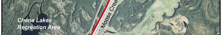
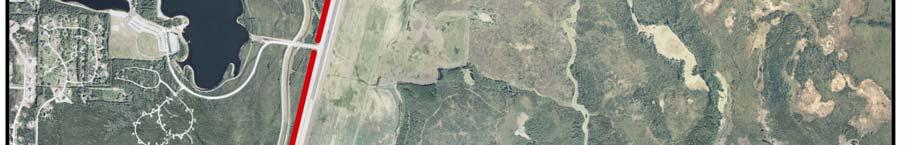
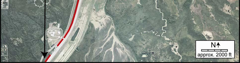
6 1.0 PURPOSE AND NEED 1.1 Proposed Action Chena River Lakes Project is in the Alaska District of the U.S. Army Corps of Engineers (USACE). It is approximately 17 miles east and 35 river miles up the Chena River from Fairbanks, Alaska. Figure 1 shows project vicinity and location. The Alaska District proposes to modify structures and operation of project features at the Chena River Lakes Project to reduce floodwater retention time and flood pool elevations during Chena River flood events. The District also proposes to clear vegetation on and near project features to allow thorough inspection, to reduce risk of dam failure, and to remove obstructions that impede discharge of flood water. The District proposes to take these actions as interim measures to reduce the risk and consequences of dam failure. The District proposes to begin implementation of these measures before the next potential flood season. This environmental assessment focuses on those immediate measures. Further interim and long-term measures may be considered later in separate processes. Figure 1. Overview of the Chena River Lakes Project (modified from USGS Report WRI ) 1.2 Project Features The primary purpose of the project is to provide flood damage reduction for the city of Fairbanks. The project also reduces flood damage in North Pole, Fort Wainwright cantonment area, and unincorporated areas in the vicinity. Much of the greater Fairbanks area is in the floodplains of the Chena and Tanana rivers. The Chena River Lakes Project reduces flood damage from the Chena River by temporarily impounding floodwater behind the Moose Creek Dam and diverting it toward the Tanana River during flood events. Tanana River flooding in the Fairbanks area also is reduced by the Tanana River Levee, another element of the Chena River Lakes Project. The Tanana River Levee is on the 1
7 north bank of the Tanana River. It separates Tanana River flood waters from the south side of the Fairbanks area. It prevents floodwater from the Tanana River from flowing into part the river's natural floodplain around Fairbanks. It was constructed by the Corps of Engineers and is owned and maintained by the Fairbanks North Star Borough. Chena River Lakes Project construction began after a 1967 flood that extensively damaged Fairbanks and surrounding communities. The project was completed in 1979 and was first operated for a test fill in Figure 2 is a project features illustration sheet that shows an overhead view of the Chena River Lakes Project. Major features are labeled. Their roles in flood control are described as follows: Moose Creek Dam - Main Embankment is a 7.5-mile-long earthfill structure that, along with a 0.7-mile extension, extends from an unnamed ridge north of the Chena River southward to the Tanana River. It reaches a maximum height of 50 feet above the Chena River streambed. The upstream side of the embankment is constructed of semi-pervious silty gravel to inhibit seepage. An upstream silt seepage blanket 600 to 1,000 feet wide and constructed of silt and 149 relief wells near the downstream toes of the dam and the toe of the stability berm also control seepage. Moose Creek Dam - Outlet Control Structure, or control works, contains four 25- foot-wide concrete bays divided by piers. Each bay is fitted with a hydraulically operated control gate. Each bay is designed to pass Chena River flows at a maximum of 3,000 cubic feet per second (cfs). Additional water may flow through the fishways on both sides of the control structure. Each fishway is a narrow, artificially roughened channel that provides a low-velocity route for fish passage through the control works until flood control operations begin. A fish ladder is operated in the control structure during high water events above feet mean sea level (MSL) when water velocity through the control gates and the fishways impedes upstream fish migration. 2

8 Figure 2. Overhead view of Chena River Lakes Project 3

9 Project Floodway is an excavated, cleared channel that is a maximum of 2,400 feet wide. It collects Chena River floodwaters for diversion to the Tanana River. The floodway is approximately 6.5 miles long. A 2,000-foot-long sheet pile sill between the floodway and the Tanana River keeps floodwater from the Tanana River from entering the floodway. Figure 3 shows the southern end of the floodway and its juncture with the Tanana River. Figure 3. Southern end of the cleared floodway and Tanana River. East Cutoff Dike is a low embankment about 5,600 feet long that prevents water from the project from entering Moose Creek drainage at high pool elevations. This feature is referred to as the East Saddle Dam in some Chena River Lakes project literature. Low Point Drains are gated structures used to remove trapped water at low points in the floodway after floodwaters have receded. Two low point drains pass through the Moose Creek Dam. They are designated the north (or main) low point drain and the south low point drain. Seepage Collection Channels collect below-dam seepage and water from the north low point drain and relief wells and direct it back to the Chena River downstream of Moose Creek Dam. They are near the dam both north and south of the river. 4
10 Moose Creek Acres Berm is a small levee that protects the community of Moose Creek Acres from water that backs up into Moose Creek during high flows on the Tanana River. Tanana River Levee extends 22 miles west from the south end of Moose Creek Dam and terminates at the confluence of the Tanana and Chena rivers. It protects the greater Fairbanks area from flooding during high water events on the Tanana River. Tanana River Levee has 11 groins and 3 seepage collector channels. Remote meteorological and gaging stations arrayed across the 2,115-square-mile Chena River drainage provide information about rainfall, temperature, snow depth, and stream flows in tributaries to help project operators predict severity and duration of floods. 1.3 Current Operations Chena River Lakes Project structures along the Tanana River are passive; they are periodically repaired and maintained but do not require operation during flood events. Some of the project structures controlling the Chena River are actively operated during flood events. Normal Chena River flows are less than 2,000 cfs, and the project typically is not operated for flood control until necessary to keep discharge in Fairbanks to less than 12,000 cfs. Chena River water is not retained by the project during normal flows; the dam control gates are open and the river flows downstream unimpeded. During flood events, when river discharge in Fairbanks exceeds or is expected to exceed about 12,000 cfs, dam control gates are partially closed to control discharge of floodwaters. Gates may be closed further as the Chena River rises or when other sources of inflow below the dam increase river discharge so that at Fairbanks it approaches 12,000 cfs. Gates also may be lowered when adult salmon are returning to spawn so that the pool fills behind the dam and a fish ladder can be used to let the salmon escape upstream past the dam. Minimum discharge of 1,000 cfs is maintained whenever control gates are lowered to ensure that fish and their habitat downstream from the dam have sufficient water. The project can regulate Chena River floodwater and/or divert it to the Tanana River. This protects low-lying lands in the floodplain downstream of the project. Those lands include most of Fairbanks, the cantonment area of Fort Wainwright, and some unincorporated areas in the vicinity. The maximum recorded flood at Fairbanks was 74,000 cfs in It inundated most of Fairbanks. The second highest recorded Fairbanks flood was 24,000 cfs in 1948, when a 16-year flood event inundated about 30 percent of the city. Operation of the project has avoided an estimated $250 to $275 million in flood-related damages since the project became fully functional after the test fill in This averages $8.9 million per year. During fiscal year 2008, the Chena River Lakes Project received 156,739 visits at the recreation areas near the Moose Creek Dam. At a conservative benefit estimate of $7 per visit, this equates to recreation benefits of about $1.1 million per year. 5
11 All elevations stated in this document are referenced to the North America Vertical Datum of 1929, NAVD29. The Chena River channel bottom at Moose Creek Dam is about 480 feet above mean sea level (MSL). At average summer flows the water surface elevation of the river at the dam is 485 to 490 feet MSL. At elevations of 495 to 496 feet MSL, the Chena River begins to overflow its banks and into the floodway. Floodwaters pool in the eastern part of the floodway until they rise above 502 feet MSL and can flow westward to the floodway control sill at the Tanana River. If floodwaters continue to rise in the floodway to reach feet MSL at the floodway sill, then they begin to flow over the sill into the Tanana River. The highest pool recorded in 30 years of Chena River Lakes Project operation was in May and June 1992, when Chena River water surface elevations rose to feet MSL. This has been only event high enough to overflow the floodway sill. 1.4 Issues and Resources of Concern Principal issues associated with floodwater retention and operation of the Moose Creek Dam control structure are public safety in the inundation area downstream of the dam, potential for flooding downstream property structures, and effects on migratory fish passage. The safety of people who are protected by the Chena River Lakes Project and who could be at risk by failure of any project component are the greatest concern. Their safety is the principal driving force leading to this action and to the decisions that will be made. Issues and concerns can be defined and categorized as follows: Dam Safety. Moose Creek Dam and the smaller and lower East Cutoff Dike were constructed primarily of silty gravel and gravel. The Moose Creek Dam was constructed on soils that are primarily sands and gravels. The East Cutoff Dike was constructed on frozen silts and organic silts that are likely underlain with sands and gravels. Water can migrate beneath both the dam and the East Cutoff Dike when floodwater is retained in the floodway. Water moving beneath both structures can weaken them and can lead to failure. Water beneath the dam or dike also raises groundwater down-gradient from them and may cause flooding in those down-gradient areas. Current risk reduction considerations call for retained floodwaters to be discharged as soon as possible and to be kept at minimum pool elevations behind dams of this type. Other measures are employed in construction and operation to minimize water movement through dams. Upstream silt blankets and relief wells have been installed at the Chena River Lakes Project to prevent water movement from causing damage to the structures and their foundations. Vegetation control may be important to prevent water from piping beneath dams, to ensure unimpeded discharge of flood waters into drainage channels, and to assist in performing effective inspection during flood events. Flooding and Loss of Property. The Chena River Lakes Project has mitigated floodwaters of the Chena River in the greater Fairbanks area for 3 decades and also has reduced flood damage from the Tanana River. The project has been a major factor 6
12 allowing Fairbanks to grow into the city it is now and in the expansion of facilities at Fort Wainwright and the role of Fort Wainwright meeting national military objectives. The project also has made it possible for housing to be constructed near the river in areas so low-lying that they could never have been developed without it. Structures in those lowlying areas could be affected by changes in project structures or operations. Changes in operation also could increase potential for flood damage and affect economic value of real property in the area. Community planning and tax values could be affected. Cultural Resources. Historic structures in Fairbanks and on Fort Wainwright could be affected by flooding or construction resulting from changes in project structures or operation. Traditional and customary uses also could be affected. Fish and Wildlife. The Chena and Tanana rivers are migratory corridors for chum and Chinook Pacific salmon. Both species spawn in the Chena River, primarily upstream of the Chena River Lakes Project. The Chena River is rearing habitat for both species and is one of the best-known grayling sport fishing streams in Alaska. Salmon juveniles and other fish are affected by Chena River flooding. Any event, natural or man-made, that causes the Chena River to overflow its banks may strand juvenile salmon, juvenile grayling, and other fish. Adult salmon pass through the control structure as they return to upstream spawning habitat. As water backs up behind the dam during flood events, water velocity through the gates becomes too great for salmon and other fish to overcome. Returning salmon adults, grayling, and other fish that might be waiting to migrate to the upper Chena River must hold downstream from the control structure until the pool behind the dam is lowered enough so that water velocity is reduced and they can pass upstream through the control structure. Salmon delayed too long during their return migration could be less able to reach spawning habitat and their reproduction could be less successful. A fish ladder can be used to allow upstream migration, but only after a flood pool is formed behind the Moose Creek Dam. Changes in project features or operation that might impede salmon returns or impede critical seasonal upstream migration by other fish would raise concern among resource agencies and others interested in the Chena River salmon fishery. Most birds and mammals that inhabit central interior Alaska are represented at the Chena project. Most are adapted, at least at the population level, to extreme subarctic climatic and floodplain conditions. Construction and operation of the Chena River Lakes Project may have affected wildlife, but effects are not readily apparent. Changes in structures, operation, or maintenance that could affect birds and mammals would be of concern to resource agencies and other interested users. 7
13 2.0 ALTERNATIVES 2.1 Range of Alternatives Four specific, immediate objectives based on the needs identified in Section 1 are as follows: Reduce retention time for floodwaters behind Moose Creek Dam Minimize flood pool elevations behind Moose Creek Dam Minimize water movement through and beneath Moose Creek Dam and the East Cutoff Dike Facilitate inspection during flood events The scope of alternatives considered in detail encompasses measures that can be employed in the near term with reasonably available resources and authorities. National Environmental Policy Act guidelines require that a full range of alternatives be considered for major Federal actions, but they allow the process to be tiered in a series of sequential actions. This environmental assessment addresses interim risk reduction measures to meet immediate needs. It also could become the first tier of a process leading to more extensive changes to facilities and operations at the Chena River Lakes Project. Section 1 also identified issues and concerns related to resources in the project area. Potential for impacts to those resources, and measures to mitigate those impacts, are evaluated for each alternative considered in detail. The single most important objective is to protect the safety of people in the area influenced by the Chena River Lakes Project. The following objectives and constraints for protection of resources were identified in addition to that central objective: Minimize impacts to salmon migrating up the Chena River Minimize stranding of fish during flood events Protect habitat identified as important to fish and wildlife Protect cultural resources Minimize damage to property and economic activities Minimize effects to water quality There also are resource protection laws and regulations that must be considered in planning. They include the Clean Water Act, the Migratory Bird Act, and many others. Any action taken would be implemented to ensure compliance with those statutes. 8
14 Alternatives in the following discussion are roughly grouped in the following objectives to help comparison, but some actions would meet more than one objective: 1. No action 2. Reduce the volume of water entering the Chena River Lakes Project 3. Modify operations to impound less water 4. Modify project features to impound less water 5. Remove vegetation to stop damage and improve inspection and operation 2.2 No Action The no action alternative must be considered in environmental assessments. The no action alternative is to continue operation of the Chena River Lakes Project as it is operated now. Project features would not be altered to lessen risk, vegetation control would not be increased, and operating instructions for the control structure would be unchanged. 2.3 Reduce the Volume of Water Entering Chena River Lakes Project Chena River floodwater could be diverted into another drainage or stored in a new reservoir upstream from the Chena Project. No measures could be implemented under existing legislative authorities to support this alternative. This alternative was studied in the 1970's during feasibility studies for the current Chena River Lakes Project. This alternative would require re-initiation of lengthy feasibility studies. Outcome would be uncertain, and no immediate action could be taken. This alternative is eliminated from detailed consideration in this environmental assessment. Earlier studies also considered diverting or impounding the Little Chena River, which empties into the Chena downstream of Moose Creek Dam. Discharge from the Little Chena adds to the total Chena River water discharge at Fairbanks. The Little Chena alone could discharge more than 12,000 cfs. Controlling discharge from the Little Chena would allow more discharge from Moose Creek Dam during high water events. Re-initiating consideration of that alternative is outside the scope of this environmental assessment but could be reconsidered in evaluations of long-term solutions to flooding in Fairbanks. 2.4 Modify Project Operations to Store Less Water Current operations release all Chena River water through the Moose Creek Dam control structure unless water must be retained or diverted to protect downstream lands from flooding. There is no reason to alter this part of project operation. When the intake structure is operated to retain Chena River water, the Alaska District coordinates with the Alaska Department of Fish and Game (ADF&G) to determine whether returning adult salmon may be in the lower Chena River. Under present operating procedures, floodwaters may be retained so water levels behind the dam are raised and the fish ladder can be used to pass returning salmon upstream. Any time the Moose Creel Dam floodgates are lowered, they are operated to release a minimum flow of 1,000 cfs to preserve downstream aquatic habitat. 9
15 2.4.1 Operations for Fish Passage The project is operated to store only as much water as required to avoid downstream flooding if a high water event is predicted to be of short duration or limited volume. Salmon are assumed to be blocked from migrating upstream at discharges of 8,000 cfs or a pool elevation of approximately 495 feet MSL. Upstream migration of salmon is halted until enough water is discharged to lower the river elevation to less than approximately 495 feet MSL or until the pool behind the dam is raised to at least feet MSL (optimally to 502 feet MSL) so that the project fish ladder can be operated. Raising the pool from 495 feet MSL to 502 feet MSL impounds approximately 14,000 acre-feet of water. The decision of whether to discharge water rapidly as possible or to retain it to allow the fish ladder to pass salmon is made collaboratively by the Corps and ADF&G biologists and hydrologists and is based on observed and predicted runoff in the Chena River drainage, weather forecasts, stage of salmon migration, and other factors. The fish ladder has been operated twice: once during the test fill in June and July 1981 when peak pool elevation reached feet MSL and again in late May and June 1985 when the flood pool reached feet MSL. The fish ladder worked well on both occasions. Fisheries resource managers who were contacted during more recent high water events have agreed that rather than operating the fish ladder, as much water as possible should be released to shorten high water events and to minimize the size and duration of the flood pool behind Moose Creek Dam. The Corps proposes to alter operations so that water would not be impounded behind Moose Creek Dam specifically to enable operation of the fish ladder for upstream fish passage. The fish ladder would be available when the pool reached enough elevation for it to function, but flood water would not be stored solely for the purpose of bringing the fish ladder into operation sooner. Eliminating this intentional impoundment could reduce stored volume by as much as 14,000 acre-feet during flood events. This action would reduce the potential for dam failure and for seepage into ground water beneath the dam. Had this measure been implemented at the beginning of project operations, it would have affected operation of the fish ladder on only two occasions for a total of 20 days. Omitting the test fill, which was not needed to protect Fairbanks, only 6 days of fish ladder operation would have been affected. Larger flood events can be expected to raise pool elevations behind the Moose Creek Dam to 502 feet MSL even if water is discharged as rapidly as possible without exceeding discharge objectives in Fairbanks. The fish ladder would be deployed and operated during any event when the pool elevation was expected to exceed feet MSL and consultation with ADF&G determined that the fish ladder was needed for salmon passage. The fish ladder would be ineffective if pool elevations exceeded 510 feet MSL. The Corps would not attempt to operate it if the flood pool was above that elevation. 10
16 This proposed action would have little effect on the time required to bring the fish ladder into operation during larger high water events. Building the flood pool to 502 feet MSL while water was released at 8,500 cfs during a 10-year flood event would take 23 hours longer and only 5 hours longer during a 100-year event Adjust Operations to Optimize Discharge Rates Water released from Moose Creek Dam downstream into the Chena River channel is restricted to approximately 8,500 cfs. This minimizes flooding in low-lying areas along the river. When the Little Chena River and other tributaries downstream were contributing relatively little water, discharge from Moose Creek Dam could be increased without exceeding the 12,000 cfs discharge objective in Fairbanks. Increasing that discharge rate through the control structure would increase potential for flooding along the river downstream from the dam, but could be implemented if better on-site monitoring at critical locations could prevent flooding in the reach between the dam and Fairbanks. The Corps proposes to modify operating procedures by stationing hydrologists or other qualified observers on the ground at critical locations during flood events when operations need to safely discharge as much water as possible without undue flooding. 2.5 Modify Project Features to Impound Less Water Two alternatives could be implemented so that Moose Creek Dam impounded less water: They are as follows: Modify the control structure so it can release more water. This would flood downstream floodplain lands unless the Chena River channel was extensively modified to contain the additional water. This cannot be implemented as an interim measure and is not considered further in this assessment. Modify the control sill at the junction of the project floodway and the Tanana River. Figure 4 shows the control sill during the highest Tanana River elevation since the sill was constructed. The sill could be lowered or gated to release Chena River floodwater into the Tanana River. Gating would require a series of long, low flood gates that could not be constructed as an interim measure. Lowering the control sill and providing for an alternative measure that could replace the sill's function is considered in detail. 11

17 Figure 4. Floodway control sill structure; Tanana River elevation 500.9, July 30, 2009 The control sill keeps Tanana River floodwater from entering the Chena River Lakes Project and the Chena River. Without the control sill, Tanana River flood waters above approximately 501 feet MSL would enter the lower section of the floodway. At approximately 502 feet MSL, floodwater would flow over the high point in the floodway and into the Chena River, adding suspended sediment to the river, increasing the volume of stored water, and impacting fish habitat. The control sill has not yet been needed. In almost 30 years of project operation, the highest Tanana River water level at the control sill was 501 feet MSL, but the sill could be important during more severe Tanana River flood events. The control sill also retains Chena River floodwater and during many high water events, and in some conditions it substantially affects maximum pool elevation in the Chena River Lakes Project. Lowering the sill from its present crest of feet MSL would lower pool elevation. The largest water volume ever stored by the project was during the 1992 flood event when the pool crested at feet MSL. The maximum pool elevation during that event would have been substantially lower if the control sill had been at 502 feet MSL. Lowering the sill would be a cost effective action to reduce both volume and duration of floodwater retention by the project. It could be implemented as an immediate interim measure. Lowering the sill would divert water into the Tanana River earlier in flood events and would reduce the maximum pool elevation during floods. This action also would reduce the probability that the flood pool would reach the East Cutoff Dike. Reducing pool elevation would reduce the potential for dam failure and lower the probability of an 12
18 uncontrolled release of pool. The smaller volume of water impounded behind the Moose Creek Dam also would reduce consequences of an uncontrolled release. A significantly larger flood would be required to reach the foot MSL pool elevation recorded during the 1992 event. Lowering the control sill would increase the probability that water from the Tanana River could enter the floodway and affect fish and aquatic habitat of the Chena River. Tanana River water in the floodway could affect groundwater in the Lyle/Nelson Road area, although it would take a major Tanana River flood event to produce a substantial pool in the floodway. The Corps would provide alternate measures to keep Tanana River flood water from reaching the Chena River. Low-permeability gravel, blocks, sandbags, and sand or other material would be stockpiled near the floodway and would be placed during floods to create a water barrier at the Richardson Highway crossing to stop Tanana River inflow. The temporary barrier would be removed after each Tanana River flood event. 2.6 Remove Sediment and Control Vegetation The Corps proposes to remove silt and accumulated organic material from stilling basins at the control works and the floodway control sill. The Corps also proposes to remove vegetation that obstructs inspection of Moose Creek Dam and vegetation that impedes water flow out of the project floodway. Those actions would help operators and inspectors identify and mitigate potential problems, reduce potential for dam failure, and expedite floodwater discharge into the Tanana River from the floodway. Removing vegetation also would reduce potential for water to seep along roots and pipe through the voids roots may leave in earthfill structures. Seepage and piping can weaken dams and increase the risk of failure. Approximately 1,500 cubic yards of silt from the Tanana River have accumulated in the stilling basin at the base of the 2,000-foot-long floodway control sill. The stilling basin keeps water flowing over the sill from eroding around and under the base. The accumulated silt and vegetation prevents inspection of the structure and impedes its function. The Corps proposes to remove accumulated material and vegetation with appropriate heavy equipment. All work would be conducted when the Tanana River is low enough so that work can be performed in the dry. Material removed during this action would be placed on upland project lands as topsoil or landscaping fill to meet project objectives. Work would be timed or limited in area to avoid effects to migratory birds. A storm water pollution prevention plan would be prepared if the total area filled with the silty material exceeded 1 acre. Less than 50 cubic yards of silty material would be removed from the control works stilling basins. Removal methods have not been determined. Small amounts of sediment adhered to the outlet structure and basin may be scrubbed off mechanically and allowed to settle to the bottom. Larger amounts would, if necessary, be removed mechanically and used for landscape fill. Dewatering a small area of the Chena River at the control works may be required. Specific plans for in-water work would be coordinated with the 13
19 Alaska Department of Fish and Game. Any timing or operational measures required to protect fish or their habitat would be incorporated into the action. The Corps proposes to clear vegetation along the toe of Moose Creek Dam and the dam extension, in the floodway upstream from the dam, and at the end of the floodway beyond the control sill. Figures 5 and 6 show the areas that would be cleared at the toe of the dam, the toe of the dam extension, and beyond the control sill. Vegetation clearing in the floodway would be at various locations where existing clearing does not extend a full 50 feet upstream from the upstream margin of the silt blanket. Areas to be cleared in the floodway are discontinuous and vary in dimension. Those areas are not shown in figures 5 and 6. Vegetation control is required by dam safety regulations and would substantially improve the Corps' ability to identify and react to events that could lead to dam failure. It also would improve water flow for project operation. Vegetation can be controlled by fire, herbicide, or mechanical methods. The Corps proposes to use only mechanical vegetation removal for interim measures. Trees valuable for firewood would, where feasible, be felled by chainsaw, roughly limbed, and made available to the public. Trees and brush at the end of the floodway past the control sill are all less than 6 inches in diameter and are not salvageable for firewood. Mechanical flails or cutters would be used to clear and chop all woody vegetation in that 31-acre area. The chopped woody vegetation would be left in place. The vegetation clearing would not excavate or grub into the earth during this action. A 50-foot-wide swath along the downstream toe of Moose Creek Dam, including the dam extension at the southern end of the dam, would be cleared for the full 7.5-mile length of the dam and the 0.7-mile length of the extension (figures 5 and 6). This area totals approximately 45 acres. An additional area of about 25 acres would be cleared in the floodway. Trees salvageable for firewood would be felled, limbed, and stacked for public use. Smaller trees and brush would be mechanically chopped or flailed. This work would be accomplished in the winter or early spring while the ground was frozen. Vegetation clearing would not excavate or grub into the earth during this action. Woody debris and felled timber could be stacked, piled, or otherwise collected only into locations that had been inspected and determined not to be waters of the United States including wetlands. Timing and clearing methods would be constrained to avoid the taking of migratory birds. Particular care would be taken near the Chena River and other water bodies to avoid introduction of sediment or woody debris and to ensure compliance with State water quality standards. The Corps will consider a separate, later action to grub or excavate roots in the cleared areas. Jurisdictional wetlands will be identified and their functions and values will be considered in additional documentation before that action is implemented. Appropriate documentation will be prepared to meet requirements of the National Environmental Policy Act and other regulations. 14


20 Figure 5. Northern segment of proposed vegetation clearing at Moose Creek Dam. 15

21 Figure 6. Southern segment of vegetation clearing at Moose Creek Dam and at the control sill. 16
22 3.0 AFFECTED ENVIRONMENT 3.1 The Project Area The Chena River Lakes Project is in central interior Alaska at approximately 64.7 N, W near the community of North Pole (population 2,099), and a short distance from Fairbanks (the second largest city in Alaska, population 30,367). The project also is near Eielson Air Force Base (population 2,858) and Fort Wainwright (population 10,906). Figure 1 shows the location of the Chena River Lake Project and those communities. The project is less than 150 miles south of the Arctic Circle. Climate is typical of interior locations in the far north. Average January temperatures range from -19 to -2 F; average July temperatures range from 49 to 71 F. Extreme temperatures range from more than -60 F to almost 100 F. The area is in discontinuous permafrost with much of the area underlain with perennially frozen ground. Annual precipitation is 11.5 inches, with 67.8 inches of snowfall. Heaviest precipitation generally is in August and September. The Chena River Lakes Project and the surrounding communities are at the border of the broad Tanana Valley. Bedrock is estimated to be about 600 feet beneath Moose Creek Dam. Continuous permafrost often forms hydrologically impermeable barriers in the far north, but groundwater moves readily through thawed gravelly strata that dominates the conditions found beneath Moose Creek Dam. The Chena River drains a total of 2,115 square miles, of which 1,496 are upstream of the Moose Creek Dam. Most of the rest of the drainage flows into the Little Chena River, which joins the Chena River downstream from Moose Creek Dam. Chena River does not receive glacier melt water or water from any other major source of suspended sediment, so water is relatively clear and the stream bottom is gravel or rocky through most of its length. Flows typically are between 1,000 and 2,000 cfs in the summer and less than 100 cfs in the winter. Peak flows generally are in two periods: in the spring when the warming sun and rain melt snow in the highlands that make up much of the Chena River drainage and in late summer, which often is rainy in Alaska. Unusually deep snow in the upper drainage may contribute to larger spring flood events, and heavy rains may exacerbate flooding from the snowmelt. Table 1, based on hydrological modeling, provides information about high water events since the project began operation. Table 1. Modeled Chena River flows Peak Inflow (cfs) 10-year flood 16, year flood 33, year flood 42, flood 19, flood 57, flood 16,600 Standard project flood 74,000 Project maximum flood 186,000 17
23 3.2 Resources of Concern Section 3 provides information about the Chena and Tanana rivers, their floodplains, and their biological and cultural resources that might be affected by alternatives identified in Section 2. It also provides information to illustrate the need for action. Principal identified resources of concern are as follows: Air Quality Water quality and river elevations Vegetation and wildlife habitat Fish, particularly salmon and grayling Mammals and their important habitat Birds and their important habitat Historic and other cultural resources Air Quality. Fairbanks is particularly susceptible to air quality problems during the winter due to increased heating requirements combined with temperature inversions during cold weather. Surrounded by hills on three sides, temperature inversions can trap a layer of cold air close to the ground. Even relatively small amounts of pollution can accumulate to unacceptable levels over periods of days or even weeks at a time. The USEPA designated the urban part of Fairbanks North Star Borough (FNSB) a nonattainment area for carbon monoxide in However, FNSB has not violated the National Ambient Air Quality Standard (NAAQS) for carbon monoxide since Since that time, EPA approved the FNSB's carbon monoxide attainment plan and the area designated in 1999 became a Carbon Monoxide Maintenance Area on September 27, All of the activities proposed in the assessment are well outside the boundaries of the carbon monoxide maintenance area. In December 2009, an expanded segment of the Fairbanks North Star Borough was designated as a nonattainment area due to due to violations of recently promulgated national ambient air quality standards (NAAQS) for particulate matter smaller than 2.5 micrometers in diameter (PM2.5) in the city of Fairbanks. The PM2.5 nonattainment area boundaries extend outside the city and are illustrated in figure 7. The nonattainment area encompasses part of the 8.2-mile-long Moose Creek Dam and extension, but does not extend to the control sill at the Tanana River. Much of the vegetation clearing would take place within the nonattainment area, but the work to lower the control sill and clear vegetation at the Tanana River would take place outside it. 18

24 Figure 7. PM2.5 Non-attainment area, Fairbanks North Star Borough. Most of the PM2.5 in Fairbanks is thought to be generated by combustion of fuel and wood for heat, electricity, and transportation. Typical PM2.5 sources include power plants, vehicles, wood burning stoves, and wildland fires. In Fairbanks, air quality problems are most prevalent during cold weather temperature inversions. Figure 8 illustrates the number of days that PM2.5 concentrations exceeded standards in downtown Fairbanks during recent winters. 19

25 Figure 8. PM2.5 exceeding standards in Fairbanks Water Quality and River Flood Elevation. Chena River is not fed by glacial runoff, and turbidity is relatively low. Principal water quality issues are associated with natural presence of elements from mineralization. Past mining probably has made metals more available to the system. Arsenic, barium, chromium, and zinc concentrations were relatively high in sediments sampled in the lower Chena River (USACE 1998). The Chena River Lakes Project and operation of the project do not appreciably affect Chena River water quality, although sediments may settle out of water impounded during flood events. Before human development in the Fairbanks area, floodwaters of the Tanana and Chena rivers comingled in their shared floodplains and periodically filled remnant channels left by meandering rivers. Silt and bedload material would have been introduced into the lower Chena River during those events. Levees, slough blocks, and drainage modifications now limit Tanana River incursions into the lower Chena River. The Chena River in the project area does not receive water from the Tanana River. Any nutrient benefit it may have gained from Tanana River sediment is lost, but light penetration for photosynthesis and sight feeding by fish and invertebrates is unimpeded by Tanana River suspended solids, and aquatic bottom habitat is not clogged with silt. Exclusion of Tanana River water may have benefited both salmon and grayling. 20
26 The floodway high point is 502 feet MSL, high enough to prevent all but the highest observed Tanana River floods from reaching the Chena River. The 2,000-foot-long control sill was placed at the floodway outlet to create an even higher Tanana River block at elevation feet. The Tanana River has not comingled with the Chena River in the project area since the project was constructed. The Chena River Lakes Project is operated to keep river discharge in Fairbanks to less than 12,000 cfs. It also is operated to minimize flooding in the 35-mile river reach between Moose Creek Dam and Fairbanks. Vegetation. Clearing vegetation would remove diverse woody vegetation from about 100 acres. Grass and herbaceous vegetation might be cut, but would soon return. Approximately 30 acres of the vegetation to be removed would be second-growth alder and poplar in the Tanana River floodplain adjacent to the control sill at the end of the floodway (figure 6). All that vegetation is less than 6 inches in diameter. The remainder, approximately 70 acres, is mixed and diverse woody vegetation along the toe of Moose Creek Dam. The area planned for clearing at the toe of the dam is a narrow strip 50 feet wide and 8.2 miles long, so vegetation varies considerably from one end to the other. The northern 3 miles is approximately 80 percent birch with occasional, scattered large white spruce nearer the Chena River. The area closer to Lake Park and the project office compound is small diameter (2 to 4 inches) black spruce-tamarack with intermittent patches of willow. From the fee booth to the Alyeska oil pipeline, vegetation is mostly dense stands of young spruce, balsam poplar, and aspen, with large spruce around the bridges. The southern 2 miles nearer the Tanana is a young stand of balsam poplar and aspen. Vegetation to be cleared in the floodway is strongly influenced by soil patterns remaining from river channels, permafrost, and other factors. Vegetation types and diversity in the floodway are similar to those along the dam toe. Wetlands are intermittent along the dam toe south of the Chena River, generally where ground water is shallow or in permafrost. There also are scattered areas of potential wetlands in the areas proposed for clearing in the floodway. Fish. Intensive fish collections from above and below the Chena River Lakes Project (USACE 1999) and earlier collections (Van Hulle; 1968, Walker 1983, and USFWS, 1984) identified the following species: Chinook salmon Chum salmon Arctic lamprey Lake chub Arctic grayling Longnose sucker Round whitefish Humpback whitefish Broad whitefish Least cisco 21
27 Sheefish Northern pike Burbot Slimy sculpin Nine spine stickleback Three of those species, Chinook salmon, chum salmon, and arctic grayling are of particular importance in the biology of the Chena River and are highly important in the Tanana River system fishery. Arctic grayling are comparatively large, are abundant in the river, are important predators, and are highly prized in the recreational fishery. Both salmon species transport important nutrient sources into the system. Grayling. Grayling overwinter in deeper water of home rivers or in glacially fed rivers. They are observed during the winter in the lower Chena. They disperse into spawning and feeding habitat as the ice begins to go out in the spring, typically in May. They have been reported to spawn over riffles with relatively small gravel, but are known to spawn on a variety of habitats and have been observed spawning in muddy sloughs of the Chena River. They typically spawn soon after ice-out as water temperatures begin to rise and stream discharges increase. Embryos hatch in about 3 weeks and emerge as fry a few days later. Fry have very little mobility in their first two weeks and flooding may cause high mortality (USACE 1999). Young of year (YoY) are more mobile, but smaller YoY still prefer quieter water where they often form dense schools. Falling water levels may strand fry and in isolated pools (Armstrong 1986). The Chena River Lakes Project floodway emulates a natural pool during flood events when the control structure gates are closed. YoY were observed in impounded water at the Chena River Lakes Project, but limited observations did not find substantial numbers of dead YoY after drawdown. Although specific data are sparse, impounding Chena River floodwater is generally understood to increase potential for mortality to grayling fry and YoY during flood events in late spring and summer. Larger sub-adult and adult grayling may move into the floodway during flood events, but little evidence of post-flood mortality has been reported. Substantially smaller Chena River grayling year classes were noted after the 1967 and 1981 Chena floods, indicating that both natural flooding before the project and flooding into the constructed floodway could have caused substantial mortality. There is no way to determine whether mortality from natural flooding before project construction was comparable with mortality from flooding into the constructed floodway during postconstruction events. Chinook Salmon. Chinook salmon spawning in interior Alaska is limited to relatively few streams. The Chena River is one of the more important spawning rivers in the middle reaches of the Yukon River drainage. Biologists (USACE 1999) estimated that approximately 6 percent of the total Yukon River Chinook harvest between 1987 and 1996 (10,800 average per year) were Chinooks contributed by the Chena River. Estimated escapement to the Chena River from 1986 to 2008 is shown in figure 9. 22
(Revised February,2005) CULVERTS, BRIDGES, AND FORDS
 CULVERTS, BRIDGES, AND FORDS") GUIDE TO STREAM CROSSINGS (Revised February,2005) CULVERTS, BRIDGES, AND FORDS Culverts, bridges, and fords are all methods used to cross-streams. Culverts are the most common stream crossing structure.
GUIDE TO STREAM CROSSINGS (Revised February,2005) CULVERTS, BRIDGES, AND FORDS Culverts, bridges, and fords are all methods used to cross-streams. Culverts are the most common stream crossing structure.
APPENDIX C VEGETATED EMERGENCY SPILLWAY. VERSION 1.0 March 1, 2011
 APPENDIX C VEGETATED EMERGENCY SPILLWAY VERSION 1.0 March 1, 2011 [NOTE: Could use a better photo more clearly showing the emergency spillway in the context of the dam.] SECTION C-1: DESCRIPTION OF PRACTICE
USING A LABYRINTH WEIR TO INCREASE HYDRAULIC CAPACITY. Dustin Mortensen, P.E. 1 Jake Eckersley, P.E. 1
 USING A LABYRINTH WEIR TO INCREASE HYDRAULIC CAPACITY Dustin Mortensen, P.E. 1 Jake Eckersley, P.E. 1 Plum Creek Floodwater Retarding Structure No. 6 is located in an area of Kyle, Texas, that is currently
Huntington District. For More Information Contact (304)
") Zoar Levee & Diversion Dam are located in the Muskingum River Basin highlighted in green to left. The Muskingum River Basin is the site of Ohio s first multiple purpose water management and land conservation
Zoar Levee & Diversion Dam are located in the Muskingum River Basin highlighted in green to left. The Muskingum River Basin is the site of Ohio s first multiple purpose water management and land conservation
Suitable Applications Check dams may be appropriate in the following situations: To promote sedimentation behind the dam.
 Categories EC Erosion Control SE Sediment Control TC Tracking Control WE Wind Erosion Control Non-Stormwater NS Management Control Waste Management and WM Materials Pollution Control Legend: Primary Category
FINAL REPORT. Yonkers Creek Migration Barrier Removal Project Wonderstump Road Del Norte County. Submitted By:
 FINAL REPORT Yonkers Creek Migration Barrier Removal Project Wonderstump Road Del Norte County Submitted By: Del Norte County Community Development Department Yonkers Creek Migration Barrier Removal Project
Illinois State Water Survey
 Illinois State Water Survey HYDROLOGY DIVISION SWS Contract Report 508 COMPARISON OF 1987 AND 1989 BED PROFILE SURVEYS OF THE LOWER CACHE RIVER by Richard Allgire Office of Sediment and Wetland Studies
STRUCTURAL STABILITY ASSESSMENT
 STRUCTURAL STABILITY ASSESSMENT CFR 257.73(d) Fly Ash Reservoir II Cardinal Plant Brilliant, Ohio October, 2016 Prepared for: Cardinal Operating Company Cardinal Plant Brilliant, Ohio Prepared by: Geotechnical
Big Spring Creek Habitat Enhancement and Fishery Management Plans
 Big Spring Creek Habitat Enhancement and Fishery Management Plans November 5, 2012 Big Spring Events and Activities Center Newville, PA Charlie McGarrell Regional Habitat Biologist Pennsylvania Fish and
Searsville Dam Removal
 Searsville Dam Removal A unique opportunity for all Presented by the Beyond Searsville Dam Coalition San Francisquito Creek flows into the San Francisco Bay near the Palo Alto Airport and Golf Course seen
WFC 50 California s Wild Vertebrates Jan. 11, Inland Waters (Lakes and Streams) Lisa Thompson
 Lisa Thompson") Inland Waters: Lakes and Streams WFC 50 11 January 2011 Lisa Thompson Fisheries Extension Specialist Wildlife, Fish, & Conservation Biology Department University of California, Davis Take home messages
Inland Waters: Lakes and Streams WFC 50 11 January 2011 Lisa Thompson Fisheries Extension Specialist Wildlife, Fish, & Conservation Biology Department University of California, Davis Take home messages
JAP Additional Information Sheet
 JAP Additional Information Sheet Block 15: Purpose and Need The USACE purpose of the project is to provide a safe and reliable whitewater park for the recreational public in a city park, which will provide
EXTENT OF OBSERVATION
 scanned for KRIS THE RESOURCES AGENCY OF CALIFORNIA Department of Fish and Game STREAM SURVEY Date: May 25 and 31, 1977. NAME: Unnamed Stream (Tributary to Sonoma Creek) COUNTY: Sonoma. STREAM SECTION:
FISHERIES BLUE MOUNTAINS ADAPTATION PARTNERSHIP
 FISHERIES A warming climate, by itself, substantially affects the hydrology of watersheds in the Blue Mountains. Among the key hydrologic changes projected under all scenarios for the 2040s and beyond
STEELHEAD SURVEYS IN OMAK CREEK
 STEELHEAD SURVEYS IN OMAK CREEK 2002 Annual Report Prepared by Chris Fisher John Arterburn Colville Confederated Tribes Fish and Wildlife Department P.O. Box 150 Nespelem, WA 99155 Prepared for Project
Minnesota Department of Natural Resources Division of Fish and Wildlife Section of Fisheries. Stream Survey Report. Luxemburg Creek.
 Minnesota F-29-R(P)-24 Area 315 Study 3 March 2016 Minnesota Department of Natural Resources Division of Fish and Wildlife Section of Fisheries Stream Survey Report Luxemburg Creek 2015 Mark Pelham Sauk
Applying Engineering Solutions to the Science of Protection and Enhancement of Aquatic Environments. Bill Holman, P.E. Stanley Consultants
 Applying Engineering Solutions to the Science of Protection and Enhancement of Aquatic Environments Bill Holman, P.E. Stanley Consultants Project Development PHASE STAGE TASKS PURPOSE I II III Investigation
Union Pacific Railroad
 Input Questions: 404/401 Pre Application Meeting, December 18, 2013, Portland, Oregon 1. What is the project purpose and need? The purpose of the project is to improve the efficiency and average velocity
Monitoring of Downstream Fish Passage at Cougar Dam in the South Fork McKenzie River, Oregon February 8, By Greg A.
 Monitoring of Downstream Fish Passage at Cougar Dam in the South Fork McKenzie River, Oregon 1998- February 8, 2 By Greg A. Taylor Oregon Dept. of Fish & Wildlife 315 E. Main Street Springfield, OR 97478
COA-F17-F-1343 YEAR END REPORT
 DAVE MARSHALL SALMON RESERVE RESTORATION, MAINTENANCE, AND UPGRADES YEAR END REPORT Prepared for: Fish and Wildlife Compensation Program Prepared by: Edith Tobe, RPBio, Executive Director Box 1791, Squamish,
NEVADA DEPARTMENT OF WILDLIFE STATEWIDE FISHERIES MANAGEMENT
 NEVADA DEPARTMENT OF WILDLIFE STATEWIDE FISHERIES MANAGEMENT FEDERAL AID JOB PROGRESS REPORTS F-20-52 2016 Lake Tahoe Rainbow Trout Study WESTERN REGION NEVADA DEPARTMENT OF WILDLIFE, FISHERIES DIVISION
Redd Dewatering and Juvenile Salmonid Stranding in the Lower Feather River,
 Redd Dewatering and Juvenile Salmonid Stranding in the Lower Feather River, 2005-2006 Interim Report for NOAA Fisheries Prepared by: California Department of Water Resources Division of Environmental Services
STREAM SURVEY File form No..
 scanned for KRIS THE RESOURCES AGENCY OF CALIFORNIA California Department of Fish and Game STREAM SURVEY File form No.. Date: September 4, 1969. NAME: North Fork Schooner Gulch Creek COUNTY: Mendocino.
Plan B Dam Breach Assessment
 Plan B Dam Breach Assessment Introduction In support of the Local Sponsor permit applications to the states of Minnesota and North Dakota, a dam breach analysis for the Plan B alignment of the Fargo-Moorhead
Five Counties Salmonid Conservation Program - Fish Passage Design Workshop. February 2013
 Program - Aquatic Organisms and Stream Crossings Ecological Connectivity A watershed is a network of channels that drain a common boundary. Channel characteristics formed by interaction of precipitation,
SKIATOOK LAKE MANAGEMENT PLAN
 SKIATOOK LAKE MANAGEMENT PLAN Background Skiatook Lake impounds Hominy Creek, 5 miles west of Skiatook in Osage County, Oklahoma (Figure 1). Skiatook Lake covers 10,540 surface acres and was constructed
Columbia Lake Dam Removal Project
 Columbia Lake Dam Removal Project The Columbia Lake dam located 1/4 mile upstream of the Paulins Kill River's confluence with the Delaware River in Knowlton Township, Warren County has been proposed for
X.B WETLANDS ROGUE RIVER ESTUARY
 X.B WETLANDS ROGUE RIVER ESTUARY The Rogue River has a drainage area of 5,100 square miles, yet the estuary of the Rogue River is one of the smallest in Oregon, measuring approximately 1,880 acres during
FACT SHEET MCGREGOR LAKE RESTORATION HABITAT PROJECT POOL 10, UPPER MISSISSIPPI RIVER, WISCONSIN ENVIRONMENTAL MANAGEMENT PROGRAM
 FACT SHEET MCGREGOR LAKE RESTORATION HABITAT PROJECT POOL 10, UPPER MISSISSIPPI RIVER, WISCONSIN ENVIRONMENTAL MANAGEMENT PROGRAM LOCATION McGregor Lake is located within a mid-river island in Pool 10
Interim Guidance Fish Presence Absence
 Interim Guidance Fish Presence Absence Source: Forest Practices Act Guidance for Division 635 of the forest practices act dealing with stream classification when no fish surveys have been done (referenced
Illinois Lake Management Association Conference March 23, 2018 By Trent Thomas Illinois Department of Natural Resources Division of Fisheries
 Illinois Lake Management Association Conference March 23, 2018 By Trent Thomas Illinois Department of Natural Resources Division of Fisheries Sources of Habitat Impairment Sedimentation Channelization
5B. Management of invasive species in the Cosumnes and Mokelumne River Basins
 5B. Management of invasive species in the Cosumnes and Mokelumne River Basins Cosumnes River The Cosumnes River basin has a number of distinct habitat types that require different management strategies
Hard Hat Services ph: hardhatinc.com 932 N. Wright St., Suite 160 Naperville, IL 60563
 Interstate Power and Light Company Ottumwa Generation Station CCR Surface Impoundment Annual Inspection Report 154.018.012.003 Report issued: December 21, 2016 Hard Hat Services ph: 877-630-7428 hardhatinc.com
Sediment Basin 7E-12. Design Manual Chapter 7 - Erosion and Sediment Control 7E - Design Information for ESC Measures BENEFITS.
 7E-12 Design Manual Chapter 7 - Erosion and Sediment Control 7E - Design Information for ESC Measures Sediment Basin BENEFITS Flow Control Erosion Control Sediment Control Runoff Reduction Flow Diversion
Juvenile Steelhead and Stream Habitat Conditions Steelhead and Coho Salmon Life History Prepared by: DW ALLEY & Associates, Fishery Consultant
 Juvenile Steelhead and Stream Habitat Conditions Steelhead and Coho Salmon Life History Prepared by: DW ALLEY & Associates, Fishery Consultant I-1. Steelhead and Coho Salmon Ecology Migration. Adult steelhead
Trout Unlimited Comments on the Scope of Environmental Impact Statement for the Constitution Pipeline Project, Docket No. PF12-9
 October 9, 2012 Kimberly D. Bose, Secretary Federal Energy Regulatory Commission 888 First Street, NE, Room 1A Washington, DC 20426 RE: Trout Unlimited Comments on the Scope of Environmental Impact Statement
Pre-Application Document Kaweah Project (FERC Project No. 298)
") TABLE OF CONTENTS Page 3.12 Aesthetic Resources... 3.12-1 3.12.1 Information Sources... 3.12-1 3.12.2 Setting... 3.12-1 3.12.3 Project Facilities... 3.12-2 3.12.4 Previous Visual Resources Assessment...
TABLE OF CONTENTS Page 3.12 Aesthetic Resources... 3.12-1 3.12.1 Information Sources... 3.12-1 3.12.2 Setting... 3.12-1 3.12.3 Project Facilities... 3.12-2 3.12.4 Previous Visual Resources Assessment...
Final Fish Salvage & Temporary Tailrace Barrier Report for the Wallowa Falls Hydroelectric Project Tailrace. (FERC No. P-308) December 18, 2017
 December 18, 2017") Final for the Wallowa Falls Hydroelectric Project Tailrace (FERC No. P-308) December 18, 2017 Prepared by: Jeremiah Doyle PacifiCorp 825 NE Multnomah Street Portland, OR 97232 December 18, 2017 Page 1
Final for the Wallowa Falls Hydroelectric Project Tailrace (FERC No. P-308) December 18, 2017 Prepared by: Jeremiah Doyle PacifiCorp 825 NE Multnomah Street Portland, OR 97232 December 18, 2017 Page 1
The Calawah River System
 The Calawah River System The Calawah River is the largest tributary of the Bogachiel River and is formed by the confluence of the north and south forks of the Calawah. The two forks of the Calawah, CALAWAH
FACT SHEET I. LOCATION
 STEAMBOAT ISLAND HABITAT REHABILITATION AND ENHANCEMENT PROJECT (HREP) SCOTT COUNTY, IOWA, UPPER MISSISSIPPI RIVER RESTORATION-ENVIRONMENTAL MANAGEMENT PROGRAM ROCK ISLAND DISTRICT FACT SHEET I. LOCATION
Marine Ecosystems. Aquatic Ecosystems Section 2
 Marine Ecosystems Marine ecosystems are located mainly in coastal areas and in the open ocean. Organisms that live in coastal areas adapt to changes in water level and salinity. Organisms that live in
LIFE HISTORY DIVERSITY AND RESILIENCE
 LIFE HISTORY DIVERSITY AND RESILIENCE SPRING CHINOOK IN THE WILLAMETTE RIVER BASIN Kirk Schroeder Brian Cannon Luke Whitman Paul Olmsted Oregon Department of Fish and Wildlife Corvallis Research Lab Thanks
Creation of Fish and Wildlife Habitat on the Closed Salmon Harbour Mine in Minto, NB
 Creation of Fish and Wildlife Habitat on the Closed Salmon Harbour Mine in Minto, NB M. Coleman 1, R. Rutherford 2, RA Currie 3 1 NB Power 2 Thaumas Environmental Consultants Ltd 3 RA Currie Ltd. Location
Climate Change Adaptation and Stream Restoration. Jack Williams;
 Climate Change Adaptation and Stream Restoration Jack Williams; jwilliams@tu.org 1 Goals for this presentation Develop strategies for adapting streams to climate impacts by Thinking like a watershed Understanding
Rehabilitation of Grimes Creek, a Stream Impacted in the Past by Bucket-lined Dredge Gold Mining, Boise River Drainage, July 2008 to August 2011.
 Rehabilitation of Grimes Creek, a Stream Impacted in the Past by Bucket-lined Dredge Gold Mining, Boise River Drainage, July 2008 to August 2011. Pam Harrington TU,1020 W. Main Street Suite 440, Boise,
Restoring the Kootenai: A Tribal Approach to Restoration of a Large River in Idaho
 Restoring the Kootenai: A Tribal Approach to Restoration of a Large River in Idaho Susan Ireland, Kootenai Tribe of Idaho Future of our Salmon Conference Technical Session August 2016 Healthy Floodplains,
EcoLogic Memorandum. TO: Ben Brezell; EDR FROM: Mark Arrigo RE: Possible Impacts of Dredging Snooks Pond DATE: 6/4/07
 EcoLogic Memorandum TO: Ben Brezell; EDR FROM: Mark Arrigo RE: Possible Impacts of Dredging Snooks Pond DATE: 6/4/07 Background EDR P.C. (EDR) has been contracted by a landowner to assess the feasibility
LAKE STOCKING POLICY FOR SPORT FISH DIVISION. Original Policy Authorized in February of 1998 Revised 04/07/2008
 LAKE STOCKING POLICY FOR SPORT FISH DIVISION Original Policy Authorized in February of 1998 Revised 04/07/2008 INTRODUCTION The stocking of lakes with hatchery reared fish was initiated in the 1950 s and
Packwood Lake Intake Screen Velocity Test Report for Energy Northwest's Packwood Lake Hydroelectric Project FERC No Lewis County, Washington
 for Energy Northwest's Packwood Lake Hydroelectric Project FERC No. 2244 Lewis County, Washington Submitted to P.O. Box 968 Richland, Washington 99352-0968 Submitted by EES Consulting 1155 North State
The Salmonid Species. The Salmonid Species. Definitions of Salmonid Clans. The Salmonid Species
 The Salmonid Species The Salmonid Species N. American salmon (2 more Asian species) Chinook ( King ) Coho ( Silver ) Sockeye Chum ( Dog ) Pink ( Humpy ) Sea-run trout Steelhead, Cutthroat, Dolly Varden
Environmental Review and Permitting for Wild Trout
 Environmental Review and Permitting for Wild Trout Tom Shervinskie Wild Trout Summit Watershed Analysis Section August 26, 2017 Division of Environmental Services The mission of the Pennsylvania Fish and
TECHNICAL MEMORANDUM 002 EMORANNO. 001
 TECHNICAL MEMORANDUM 002 EMORANNO. 001 To: Jack Synder, P.E. EES Consulting From: Mort McMillen, P.E. Paul Larson, SE Date: October 13, 2010 Project: Cc: Taylor Bowen Subject: Technical Memorandum (TM)
Frequently Asked Questions About Revised Critical Habitat and Economic Analysis for the Endangered Arroyo Toad
 Q Frequently Asked Questions About Revised Critical Habitat and Economic Analysis for the Endangered Arroyo Toad Q. What is the arroyo toad? The arroyo toad (Bufo californicus) is a small, light greenish-grey
Emergent Sandbar Habitat Program Middle Missouri River
 Emergent Sandbar Habitat Program Middle Missouri River Jeremiah Szynskie, P.E. Hydrologic Engineering Branch Introduction Main Stem System Dam Closures Fort Peck 1937 Fort Randall 1952 Garrison - 1953
Construction Dewatering
 Construction Dewatering Introduction The control of groundwater is one of the most common and complicated problems encountered on a construction site. Construction dewatering can become a costly issue
Hard Hat Services ph: hardhatinc.com 932 N. Wright St., Suite 160 Naperville, IL 60563
 Interstate Power and Light Company Ottumwa Generation Station CCR Surface Impoundment Annual Inspection Report 154.018.015.003 Report issued: July 03, 2017 Hard Hat Services ph: 877-630-7428 hardhatinc.com
Proposed Reclassification of Cherry Creek, North Platte River Basin, Wyoming. October 25, 2010
 Proposed Reclassification of Cherry Creek, North Platte River Basin, Wyoming October 25, 2010 Waterbody: Location: Tributary to: Cherry Creek - Mainstem from headwaters downstream to the confluence with
Annex E Bridge Pier Protection Plan
 Annex E Bridge Pier Protection Plan Table E1 Bridge Types and Locations Table E2 Flow Conditions For River Sections Figure E1 Bridge Abutment Protection Figure E2 Bridge Pier Protection Figure E3 Central
The Blue Heron Slough Conservation Bank
 1 The Blue Heron Slough Conservation Bank CONSERVATION BANKING July 19-23, 2010 CASE STUDY SERIES The Blue Heron Slough Conservation Bank (Washington) I. OVERVIEW & BACKGROUND: Location: Snohomish River
Report prepared for: Prepared by: January 2002 BEAK Ref
 AQUATIC ENVIRONMENTAL STUDY KANATA WEST CONCEPT PLAN Report prepared for: ROBINSON CONSULTANTS Prepared by: BEAK INTERNATIONAL INCORPORATED 14 Abacus Road Brampton, Ontario L6T 5B7 January 2002 BEAK Ref.
Chadbourne Dam Repair and Fish Barrier
 Chadbourne Dam Repair and Fish Barrier Final Report for the Western Native Trout Initiative Prepared by: Carol Endicott Yellowstone Cutthroat Trout Conservation Biologist Montana Fish, Wildlife & Parks
Colusa Basin Drain Watershed Fish Stranding Tour Concept Paper Mike Hendrick and Brycen Swart NMFS
 Colusa Basin Drain Watershed Fish Stranding Tour Concept Paper Mike Hendrick and Brycen Swart NMFS On May 31, 2013 representatives from CDFW, USFWS, and NMFS went on a field tour to look at locations in
San Lorenzo Valley Water District, Watershed Management Plan, Final Version Part I: Existing Conditions Report
 LIST OF FIGURES Figure 1-1. Map of the San Lorenzo River watershed Figure 2-1. The Santa Cruz Mountains Bioregion Figure 2-2. Protected areas within the San Lorenzo River watershed Figure 2-3. Primary
At Home on the Elbow River. -Ours to share-
 At Home on the Elbow River -Ours to share- Living in the shed You are part of the Elbow River Watershed. The Elbow River and its tributaries drain over 1,200 km² of land. The source of the Elbow River
Outline. 1. Overview 2. Population 3. Flooding 4. Land Use 5. References. Overview
 Outline 1. Overview 2. Population 3. Flooding 4. Land Use 5. References Overview The two main rivers in the Cannon River watershed are the Cannon and Straight Rivers. The Cannon River originates in Shields
Regulations. Grabbling season May 1 July 15; only wooden structures allowed.
 Arkabutla Reservoir 219 REEL FACTS Keith Meals, Arthur Dunn, Stanley Turner Fisheries Biologists keithm@wfp.ms.gov, ArthurD@wfp.ms.gov, StanleyT@wfp.ms.gov General Information: Arkabutla Reservoir is one
Final Fish Salvage & Temporary Tailrace Barrier Report for the Wallowa Falls Hydroelectric Project Tailrace. (FERC No. P-308) December 20, 2018
 December 20, 2018") Final Fish Salvage & Temporary Tailrace Barrier Report for the Wallowa Falls Hydroelectric Project Tailrace (FERC No. P-308) December 20, 2018 Prepared by: Jeremiah Doyle PacifiCorp 825 NE Multnomah Street
Final Fish Salvage & Temporary Tailrace Barrier Report for the Wallowa Falls Hydroelectric Project Tailrace (FERC No. P-308) December 20, 2018 Prepared by: Jeremiah Doyle PacifiCorp 825 NE Multnomah Street
Upper/Lower Owl Creek Reservoir
 Upper/Lower Owl Creek Reservoir Schuylkill County 2018 Largemouth Bass Survey Upper Owl Creek Reservoir and Lower Owl Creek Reservoir are 67-acre and 26-acre impoundments, respectively, created by two
FISH PASSAGE ALTERNATIVES ANALYSIS ON PENNYPACK CREEK AT VERREE ROAD DAM AND ROOSEVELT BOULEVARD DAM PHILADELPHIA, PENNSYLVANIA
 FISH PASSAGE ALTERNATIVES ANALYSIS ON PENNYPACK CREEK AT VERREE ROAD DAM AND ROOSEVELT BOULEVARD DAM PHILADELPHIA, PENNSYLVANIA Prepared for: One Parkway, 10 th Floor 1515 Arch Street Philadelphia, PA
D.B. Wilson Station CCR Landfill
 D.B. Wilson Station CCR Landfill Disposal of Coal Combustion Residuals (CCR) from Electric Utilities Final Rule Closure and Post-closure Care Plan October 11, 2016 Prepared By: Project ID: 160030A Big
Abundance of Steelhead and Coho Salmon in the Lagunitas Creek Drainage, Marin County, California
 scanned for KRIS Abundance of Steelhead and Coho Salmon in the Lagunitas Creek Drainage, Marin County, California Prepared for: Marin Municipal Water District 220 Nellen Drive Corte Madera, California
Okanagan Sockeye Reintroduction
 Okanagan Sockeye Reintroduction Backgrounder Elders accounts, and other forms of Traditional Ecological Knowledge (TEK) tell us that many species of salmon once came into the Okanagan Valley and tell us
1.Mill Creek Watershed Summary Description and Land Use
 1.Mill Creek Watershed Summary Description and Land Use Table xxx: Mill Creek Watershed Overview Watershed Size 31,435 acres/49.1 sq miles/ 127.1 sq km Elevation Range 5,594 feet [4,967-10,561] Stream
Guidance Note. Hydropower Guidance Note: HGN 8 Fish Passage. When do you need to install a fish pass?
 Guidance Note Hydropower Guidance Note: This guidance note is not intended as a statement of law. It should be read in combination with, and in the context of, the relevant enactments and EU obligations.
OKANAGAN RIVER RESTORATION INITIATIVE - FAQ
 OKANAGAN RIVER RESTORATION INITIATIVE - FAQ Initiative background: The health of the q awsitk w (Okanagan River) has been severely impacted by the channelization works that occurred in the mid-1950 s.
FINAL Caples Lake Fisheries Management Plan. Version 4.0
 FINAL Caples Lake Fisheries Management Plan Version 4.0 August 15, 2008 Purpose The Caples Lake Fisheries Management Plan (Plan) outlines the stocking plan to reestablish a sport fishery in Caples Lake
Chinook Salmon. The Yukon River Panel
 Chinook Salmon and The Yukon River Panel Jan Conitz, ADF&G UAF FISH 493 Discussion January 26, 2016 Discussion Outline I. Yukon River context Salmon and Yukon River basics Fishing and history on the Yukon
FISH PASSAGE IMPROVEMENT in California s Watersheds. Assessments & Recommendations by the Fish Passage Forum
 FISH PASSAGE IMPROVEMENT in California s Watersheds Assessments & Recommendations by the Fish Passage Forum FISH PASSAGE IMPROVEMENT in California s Watersheds The mission of the Fish Passage Forum is
Steelhead Society of BC. Thompson River Watershed Restoration and Enhancement Project #4 Nicola River Bank Stabilization and Enhancement Project
 Steelhead Society of BC Presents: Thompson River Watershed Restoration and Enhancement Project #4 Nicola River Bank Stabilization and Enhancement Project Application for Funding December 2013 1.0 BACKGROUND
Study 9.5 Fish Distribution and Abundance in the Upper Susitna River
 Initial Study Report Meeting Study 9.5 Fish Distribution and Abundance in the Upper Susitna River October 15, 2014 Prepared by R2 Resource Consultants, Inc. 10/15/2014 1 Study 9.5 Objectives 1. Describe
Fish Community. Fish Habitat, Streams and Rivers
 Clear, Ston(e)y and White Lake Plan Fish Community The lakes support a cool/warm water fishery including muskellunge, walleye, largemouth and smallmouth bass, yellow perch, pumpkinseed, rockbass, blue
Columbia Lake Dam Removal Project
 Columbia Lake Dam Removal Project Major Goals of the Columbia Lake Dam Removal: Reconnect 10 miles of the Paulins Kill River to the Delaware River, restoring natural flow regime and sediment transport.
ALASKA DEPARTMENT OF FISH AND GAME DIVISION OF COMMERCIAL FISHERIES NEWS RELEASE
 ALASKA DEPARTMENT OF FISH AND GAME DIVISION OF COMMERCIAL FISHERIES NEWS RELEASE Sam Cotten, Commissioner Scott Kelley, Director Contact: Pat Shields, Area Management Biologist or Phone: (907) 262-9368
DECISION MEMO. Pursuant to 36 C.F.R (e), the following persons are exempted from this order:
, the following persons are exempted from this order:") DECISION MEMO Forest Supervisor s Orders for the Upper Tellico Off-Highway Vehicle System USDA Forest Service Southern Region Nantahala National Forest Tusquitee Ranger District Cherokee County, North
DECISION MEMO Forest Supervisor s Orders for the Upper Tellico Off-Highway Vehicle System USDA Forest Service Southern Region Nantahala National Forest Tusquitee Ranger District Cherokee County, North
Study Update Tailrace Slough Use by Anadromous Salmonids
 Study Update Tailrace Slough Use by Anadromous Salmonids Goals and Objectives Identify what anadromous salmonids use the tailrace slough by: Life Stage (Juvenile, migrating and spawning adults) Timing
6TH PELLETIER BROOK LAKE T15 R9, Aroostook Co. U.S.G.S. Gardner Pond, Maine (7 1/2 )
") 6TH PELLETIER BROOK LAKE T15 R9, Aroostook Co. U.S.G.S. Gardner Pond, Maine (7 1/2 ) Fishes Brook trout Minnows Blacknose dace Pearl dace Physical Characteristics Area - 27 acres Average depth - 2 feet
6TH PELLETIER BROOK LAKE T15 R9, Aroostook Co. U.S.G.S. Gardner Pond, Maine (7 1/2 ) Fishes Brook trout Minnows Blacknose dace Pearl dace Physical Characteristics Area - 27 acres Average depth - 2 feet
Shovelnose Creek Off-Channel Complex Berm Repair
 Shovelnose Creek Off-Channel Complex Berm Repair Recent high discharge events have put valuable off-channel salmonid rearing and spawning habitat at risk in the upper Squamish River. This document is a
RESILIENCE THROUGH RESTORATION
 RESILIENCE THROUGH RESTORATION RECLAMATION DISTRICT NO. 1601 TWITCHELL ISLAND SAN JOAQUIN RIVER SETBACK LEVEE PROJECT TWITCHELL ISLAND BASICS Nearly 12 miles of levee Storm drainage facilities Protects
Estuarine Shoreline Stabilization
 Estuarine Shoreline Stabilization Property Owner s Guide to Determining the Most Appropriate Stabilization Method Estuarine shorelines are dynamic features that experience continued erosion. Land is lost
What I ve Learned About Dam Safety Good, Bad and Ugly
 What I ve Learned About Dam Safety Good, Bad and Ugly Ron Gruzesky Dam Safety and Floodplain Compliance Kentucky Division of Water Department for Environmental Protection August 26, 2015 What is a Dam?
Regulations. Grabbling season May 1 July 15; only wooden structures allowed.
 Grenada Reservoir 218 REEL FACTS Keith Meals, Arthur Dunn, Stanley Turner Fisheries Biologists keithm@mdwfp.state.ms.us, ArthurD@mdwfp.state.ms.us, StanleyT@mdwfp.state.ms.us General Information: Grenada
Manual of Fisheries Survey Methods II: with periodic updates. Chapter 22: Guidelines for Sampling Warmwater Rivers with Rotenone
 Manual of Fisheries Survey Methods II: with periodic updates : Guidelines for Sampling Warmwater Rivers with Rotenone P. W. Seelbach, G. L. Towns, and D. D. Nelson Suggested citation: Seelbach, Paul W.,
Managing Woodlands for Wisconsin s Coastal Trout Streams
 Protecting Water Quality and Stream Habitat 1 in Wisconsin streams in Lake Superior (left) and Lake Michigan (right) watersheds. Watershed boundaries ONE-THIRD OF WISCONSIN S TROUT STREAMS FLOW INTO LAKE
Coho Salmon 1. COMMON NAMES: Silver salmon, Coho, blue back, silversides, and jack salmon.
 Coho Salmon 1 BACKGROUND 2 COMMON NAMES: Silver salmon, Coho, blue back, silversides, and jack salmon. DESCRIPTION: In the ocean the Coho is metallic blue on its back with silvery sides and white bellies.
Winter Drawdown Issues of Concern
 Winter Drawdown Issues of Concern Wetland Connectivity Amphibians Fisheries Winter Drawdown Wetland Connectivity Wetland complex near Osprey Creek is not responsive to lake level Wetland at upper end of
COLUMBIA LAKE DAM REMOVAL PROJECT
 COLUMBIA LAKE DAM REMOVAL PROJECT Major Goals of the Columbia Lake Dam Removal: Reconnect 10 miles of the Paulins Kill River to the Delaware River, restoring natural flow regime and sediment transport.
REPORT TO THE MINISTER OF NATURAL RESOURCES. Pursuant to an appointment made by the Honourable Frank S. Miller, Minister of Natural
 Room 569, Fifth Floor, Mowat Block, Queen's Park, Toronto, Ontario. M7A la2 IN THE MATTER OF The Lakes and Rivers Improvement Act; AND IN THE MATTER OF An application by Rudolph Adam for approval under
B-36
 B-35 B-36 B-37 B-38 B-39 B-40 B-41 B-42 B-43 B-44 B-45 B-46 From: Oliver, Ross C. Sent: Friday, November 08, 2002 8:41 PM To: Kenneth Sims Cc: Badger, Phil C.; Schaefer, Hillary; Richey, Alan C Subject:
Strategies for mitigating ecological effects of hatchery programs
 Strategies for mitigating ecological effects of hatchery programs Some case studies from the Pacific Northwest Kathryn Kostow Oregon Department of Fish and Wildlife Ecological risks occur when the presence
10 is bounded by wetlands between RM 1.8 and 3.1 on the south shore and more are scattered
 The Ozette System The Ozette watershed is made up of several lakes and large streams that combine to a total drainage area of 88.4 square miles. The most significant feature of the Ozette watershed is