SUMMARY OF FISH INDEX SITE MONITORING IN WATERSHEDS WITHIN MENDOCINO REDWOOD COMPANY'S OWNERSHIP IN MENDOCINO AND SONOMA COUNTIES:
|
|
|
- Cori Douglas
- 5 years ago
- Views:
Transcription
1 SUMMARY OF FISH INDEX SITE MONITORING IN WATERSHEDS WITHIN MENDOCINO REDWOOD COMPANY'S OWNERSHIP IN MENDOCINO AND SONOMA COUNTIES: MENDOCINO REDWOOD COMPANY P.O. BOX 489 FORT BRAGG, CA DECEMBER 1999
2
3 OVERVIEW In response to the lack of information available on trends in juvenile salmonid densities in watersheds within the ownership of Louisiana-Pacific Corporation in Mendocino and Sonoma counties (now Mendocino Redwood Company, [MRC]), electrofishing sites were sampled beginning in Data was collected at these sites to develop baseline data of the salmonid densities; to observe changes over time, and to document distribution offish species throughout the various watersheds. Many of the initial electrofishing sites were sampled to collect data for individual timber harvest plans (THPs). In 1991, in the Albion River watershed, a watershed monitoring plan was developed and implemented which included permanently marking electrofishing sites and adding sites yearly to begin to develop baseline data in this area. Sites in other watersheds were also permanently marked and data collection continued. However, due to a variety of circumstances, gaps exist in data gathered at some electrofishing sites throughout the study area. Doloffet. al. (1993) cite inventories of habitat and fish density trends as primary sources of information for the evaluation of watershed conditions and the management of aquatic resources. With this in mind, MRC wanted to consolidate, analyze and report all existing juvenile salmonid density monitoring data throughout the ownership. Although not all sites were monitored in all years, the value of the collected data is the development of baseline information, which will be used by MRC to look at juvenile salmonid density trends over time. The analysis and consolidation of this data identifies areas where salmonid species numbers show a downward trend in densities. Further investigation offish densities is needed in these areas to determine the cause of declining trends in fish densities and to consider restoration or enhancement work. Areas where salmonid density trends are stable or increasing were also identified. These areas are meaningful in determining important components of fish habitat where production is successful. A semiquantitative electrofishing method is presented as a way to increase the number of sites which can be visited, decrease survey time, and increase reliability of data gathered through wider coverage in particular watersheds. Reports on fish distribution, stream temperature monitoring and habitat typing and several watershed analyses exist for areas, which overlap juvenile salmonid density monitoring sites. With the variety of extraneous factors which can affect fish during different life history stages (e.g. fishing pressure, predation, disease, flow conditions, weather cycles, and ocean cycles) it is critical to use all available information in making management decisions with regards to aquatic resources in forested watersheds.
4 INTRODUCTION Estimating juvenile salmonid numbers in terms of distribution and abundance is an important part of fisheries management, yet actually assessing the number offish in a stream is a difficult problem. Fish are highly mobile, difficult to see, difficult to catch, and live in three dimensions (Overton and McDonald 1998). The abundance of juvenile salmon and trout in streams is a function of many factors including abundance of newly emerged fry, quantity and quality of suitable habitat, abundance and composition of food and interactions with other fishes, birds and mammals (Meehan 1991). The Albion, Garcia, and Big River watersheds as well as Elk, and Willow Creek in Mendocino and Sonoma Counties support populations of coho salmon (Oncorhynchus kisutch) and steelhead trout (0. mykiss). Greenwood Creek in Mendocino County supports a population of steelhead trout '(0. mykiss) both anadromous and resident. Juvenile coho salmon typically rear in freshwater for one year before migrating to the ocean. Steelhead trout can spend several years rearing in freshwater before migrating to the ocean (Everest 1987). To develop a better understanding of fish density trends in these systems, multiple-pass removal method electrofishing was initiated in Drainage descriptions Table 1. Watershed area and percent MRC forestlands. Watershed Watershed Area (sq. mi.) MRC Ownership (sq. mi.) MRC Ownership (%) Garcia River Big River Greenwood Creek Elk Creek Albion River Willow Creek Table 2. Watershed species composition in MRC forestlands. Watershed Coho Salmon Steelhead Other Species * Garcia River X X SCP, TSS, SS, PL Big River X X SCP,TSS, PL Greenwood Creek X SCP,TSS, PL Elk Creek.. X X SCP,TSS, PL Albion River X X SCP,TSS, PL Willow Creek X X SCP,TSS, PL * = SCP- Sculpin (Cottus sp.), TSS- Three spine stickleback (Gasterosteus acluleatus), SS- Sacramento sucker (Castomus occidentalis), and PL- Pacific lamprey (Lampetra tridentatd)
5 The mouth of the Garcia River is approximately 44 miles south of Fort Bragg and just north of the town of Point Arena. This coastal watershed drains into the Pacific Ocean and is located in southwestern Mendocino county, California, at 123 degrees 44' W latitude and 38 degrees 56' N. The Garcia River watershed encompasses an area approximately 114 square mile in size and divided into twelve different planning watersheds. Elevation ranges from sea level to 2,470 feet. Mendocino Redwood Company holds 16% of the Garcia River watershed; however, of the 5,600 acre South Fork Garcia planning watershed (where the fish population index stations were located), MRC owns 92 percent. Coho salmon (0. kisutch) and steelhead (0. mykiss) are currently known to reside in the watershed. In addition, fall run chinook salmon (0. tshawytscha) are reported to have occurred historically in the mainstem Garcia River (The Garcia River Enhancement Plan, 1992). Big River is a coastal watershed that drains into the Pacific Ocean and is located in Mendocino county, California, at 123 degrees 46' W latitude 39 degrees 18' N longitude. The mouth is located on the south side of the town of Mendocino and approximately 10 miles south of Fort Bragg. This watershed is about 118 square miles and includes ten planning watersheds. Big River rises from sea level to 2,810 feet in elevation. MRC ownership contains 45% of the Big River watershed. Coho salmon and steelhead are currently known to reside in the watershed. The South Coast area includes Greenwood and Elk Creek. Greenwood Creek is a coastal stream, which drains into the Pacific Ocean approximately 30 miles south of Fort Bragg and just north of the town of Elk. This watershed is located in Mendocino county, California, at 123 degrees 42' W latitude 39 degrees 07' N longitude. The drainage area encompasses roughly 31 square miles, with elevations ranging from sea level to 1,600 feet above sea level. Three planning watersheds make up the Greenwood WWAA and MRC owns about 48% of the land in this watershed. Steelhead trout are currently known to reside in the watershed. Historic records (California Department of Fish and Game [CDFG]) of Greenwood Creek dating back to the late 1960's show presence of steelhead trout but coho salmon are not believed to have been present in this watershed. Elk Creek is a coastal watershed that drains into the Pacific Ocean and is located in Mendocino county, California, at 123 degrees 42' W latitude 39 degrees 05' N longitude. The mouth is approximately 32 miles south of Fort Bragg and just south of the town of Elk. Elk Creek watershed includes about 29 square miles and comprises two planning watersheds. Elevations in the basin range from sea level to 2,736 feet MRC owns approximately 76% of the watershed. Coho salmon and steelhead are currently known to reside in the watershed. The Albion River is located in Mendocino county, California, at 123 degrees 46' W latitude and 39 degrees 14' N longitude and drains into the Pacific Ocean approximately 17 miles south of Fort Bragg and 125 miles north of San Francisco. The Albion River watershed encompasses roughly 43 square miles. Elevations in this basin range from sea level to 1,120 feet. The Albion River is comprised of four planning watersheds, with MRC's holdings including approximately 54 percent. Coho salmon and steelhead are currently known to reside in the watershed. Willow Creek drains into the Russian River just before the Russian flows into the Pacific Ocean in Sonoma County, California. The mouth of Willow Creek is approximately 60 miles south of the town of Point Arena. The basin is about 18 square miles and elevations range from 80 feet to 1,480 feet. MRC timber-lands comprise approximately 28% of the Willow Creek planning watershed. Coho salmon and steelhead are currently known to reside in the watershed.
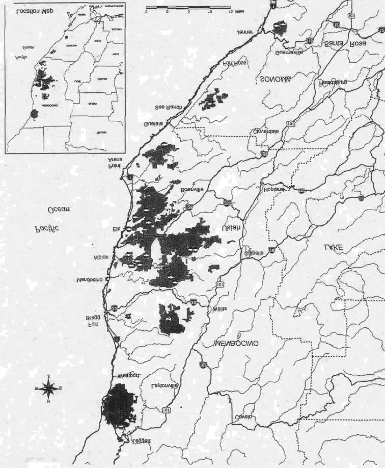
6 GOAL AND OBJECTIVES The original scope of the index station monitoring project was to gather time-series data on relative abundance of fish and evaluate trends within individual streams. Due to personnel changes, variability in resources allocated to continue monitoring all sites, and ultimately the sale of the ownership where juvenile salmonid density monitoring was performed, the progress of this project as well as analysis of the data were not well documented or summarized. The goal of this report was to summarize and evaluate ten years of electrofishing data from juvenile salmonid density monitoring sites and establish base line data to look at trend monitoring in the future. In order to achieve this goal, a database was created to expedite the analysis of a large amount of data and make future data analysis readily accessible. Summaries and analysis of juvenile salmonid density monitoring data are presented in this report as a resource to be used by Mendocino Redwood Company in making informed decisions on land use practices within forested watersheds which might impact fisheries resources. The objective of juvenile salmonid density site sampling is to monitor species composition and relative abundance of species, especially coho salmon and steelhead trout during their juvenile life stage in freshwater, over time. This type of sampling is not an attempt to quantify total fish populations as there are many factors influencing these anadromous populations: such as year class variability, ocean mortalities, parasitism, over fishing, predation, density-dependent effects, and limiting freshwater habitat. METHODS Juvenile salmonid density monitoring was conducted in streams within Louisiana-Pacific Corporation's (L-P) ownership, currently Mendocino Redwood Company, in the Albion, Big River, and Garcia River watersheds in Mendocino County. Smaller South Coast area streams (Elk Creek and Greenwood Creek) in Mendocino County were also monitored. In Sonoma County, electrofishing sites were located in Willow Creek, a tributary to the Russian River (Figures la- Ig). The number of sites surveyed increased from two in 1987 to a high of 19 in Some sites were not surveyed each year. Juvenile salmonid density monitoring stations were demarcated with plastic tags posted on streamside trees. Juvenile salmonid density monitoring was conducted in late summer and early fall when stream discharge was at a minimum and higher summer temperatures have abated. Stations were electro fished with a Smith-Root Model 12-backpack electrofisher (Smith-Root Inc., Vancouver, WA), using a multiple pass removal method. The minimum length for each index monitoring station was 30m, however, stations varied in length because complete habitat units were included to define an index station. Prior to electrofishing, each habitat unit was blocked on the upstream and downstream end with nylon block nets (mesh size 4.8 mm). One field crew-member electrofished while the other crew member(s) netted stunned fish and placed them in five-gallon buckets filled with stream water. Water in the buckets was aerated using a battery-operated (DC) aerator. Upon completion of each electrofishing pass, fork lengths and wet weights were measured for every collected fish. Fork lengths were measured using a plastic tray equipped with a ruler and wet weights were determined with an Ohaus CT600 digital balance (Ohaus Corporation, Fiorham Park, NJ). Prior to 1991, biomass data was gathered by using a graduated cylinder to obtain a displacement measurement for a group of fish rather than individuals. Successive electrofishing passes were made within each habitat unit until a 50 percent reduction in the number offish from the preceding pass was achieved. After all electrofishing passes were completed, fish were released back into the habitat unit from which they were captured.
7 Stream physical parameters (i.e. length, width, depth, and discharge) were measured and recorded for each habitat unit of the survey stations. Width and depth measurements were taken at fixed intervals over the length of each habitat unit and then averaged. Stream discharge was measured with a Marsh- McBimey flow meter (Marsh-McBimey Inc., Gaithersburg, MD) and a top set wading rod. Fish densities were calculated using data attained from multiple-pass removal surveys combined with stream physical parameters. The data from these surveys was analyzed using Microfish 3.0 software (Van Deventer and Platts 1985) which calculated the expected fish densities for individual species at each index station. RESULTS Tables l-9a summarize stream physical parameters and locations of each survey station. Coho salmon (0. kisutch), steelhead trout (0. mykiss), threespine stickleback (Gasterosteus aculeatus), Pacific lamprey (Lampetra tridentata) and sculpin (Cottus spp.) comprised the fish species found at monitoring sites in the Garcia River, Big River, Elk Creek, Greenwood Creek, Albion River, and Russian River watersheds from Not all species were found at every site or stream; Table 2 shows species present by watershed. Salmonids are the focus of this report. Density tables and charts Observed and expected salmonid relative densities (numbers of fish/m 2 ) are shown in Tables lb-9b. Expected relative densities are the site population estimates achieved by running site data through Microfish 3.0. Information in these tables varies by year as not every site was monitored every year. In 1987, monitoring stations ES-16 and 17 in the Garcia River watershed were the only sites monitored. Number of sites monitored per year gradually increased with all nineteen sites being monitored in The Albion River watershed has the most consistent data with all seven sites in this watershed monitored continuously from Figures 2a - 2h compare annual coho and steelhead densities on a watershed basis. These figures are based on observed densities. Steelhead numbers for two index monitoring sites in the Garcia watershed (Fig. 2a) show densities at a high in 1987 then dropping off through 1993 and rising again in High densities ranged from fish/m 2 and low densities from fish/m 2. The last year these sites were monitored was 1994 when densities ranged from fish/m 2. Coho were found at the SF Garcia site in 1987 only. No chart was created, however, coho density was 0.1 fish/m 2. In the Big River watershed, steelhead densities for four monitoring sites are shown in Figure 2b. From , only Gates Cr. - Upper and Lower sites were monitored. Density trends at these sites varied with Gates Cr. - Lower showing an increase in density over the years (from fish/m 2 ) and Gates Cr. - Upper increasing from fish/m 2 and then dropping off to 0.2 fish/m 2 in It is difficult to do much comparison with only two years of data at the Big Rv. and NF Big Rv. sites, however both showed slight declines in density from Six coho salmon were found at the NF Big Rv. site in South Coast Area monitoring sites include two creeks with separate drainages - Elk Creek and Greenwood Creek. Each creek has two monitoring sites, a lower and an upper. Sites were, monitored from , with the exception of 1991 when none of the sites were monitored. Steelhead densities show an overall upward trend from (Figure 2c). All sites showed higher densities in 1994 than in 1990, with Elk Creek - Upper and Greenwood Creek - Lower actually doubling their steelhead
8 densities in 1994 (from fish/m 2 and from fish/m 2, respectively). Coho salmon were found in 1992 only at the Elk Creek - Lower and Upper sites. Densities were 0.3 and 0.0 fish/m 2, respectively. The 0.0 indicates that fish were present in sufficiently low abundance that rounding resulted in 0.0 fish/m 2. The most consistently monitored watershed from the onset of index station electrofishing was the Albion River watershed. Monitoring began here in 1988 with one site and from , all seven of the sites in this watershed were monitored. Overall, steelhead densities in the Albion River are on a downward trend. Density values in 1996 ranged from fish/m 2 for all sites (Figure 2d). However, high densities for these sites were approximately 0.4 fish/m 2 with the exception of Railroad Gulch, which had highs of 1.6 fish/m 2 in 1989, and 0.5 and 0.6 in 1991 and 1992, respectively. The Mainstem Albion - Imile above the conf. site spiked a high of 0.9 fish/m 2 in Coho salmon were consistently present in the Albion River watershed (Figure 2e). Year to year comparisons are difficult for coho as they show a very distinct three-year life history trend. Figure 2f demonstrates this trend. For the most recent year of data (1996) coho are mainly comprised of progeny from the 1993 year-class. Densities remained stable or dropped slightly at three of the sites; Mainstem Albion - Lower, Mainstem Albion - Imile above confluence, and SF Albion - above confluence. More significant declines (between 0.3 and 0.4fish/m 2 ) in density were noted at the Mainstem Albion - at confluence, SF Albion - Imile above confluence, and SF Albion - near Larmer Gulch sites. The Railroad Gulch site showed a 0.3 fish/m 2 increase from 1993 to In comparing 1996 data to 1990, the first year this cohort was measured, density increased at all three sites (Mainstem Albion - at confluence, Mainstem Albion - Imile above confluence, and Railroad Gulch) in Increases in density ranged from fish/m 2. Sites in the Willow Creek watershed were the only sites from Sonoma County. There was an upper and a lower site in Willow Creek and both were monitored from In 1992, the Willow Creek - Upper site was not monitored and in 1994, Willow Creek - Lower was not monitored. Steelhead densities at the two sites demonstrated opposite trends over the years (Figure 2g). The Willow Creek - Lower site increased, then decreased then increased again and on the last survey in 1993, had a steelhead density of 0.4 fish/m 2. Conversely, the Willow Creek - Upper site steelhead density decreased then increased and increased to high of 0.6 fish/m 2 on the last survey in Coho salmon were found in 1990 only at the Willow Creek - Upper site. Coho density was 0.4 fish/m 2. Biomass and length-frequency distributions Salmonid relative biomass and fork length distributions are shown in Tables 1-9C. Length distributions for each species collected during electrofishing are expressed as number offish measured with the range of fork lengths in parentheses. Length-frequency distributions for coho salmon and steelhead are shown by watershed in Figures 3a - 3g. Size-class to age-class breakdowns are similar for coho salmon and steelhead (0-70 mm = 0+, mm = 1+, > 130mm=2+). In the Garcia River watershed, the majority of steelhead found in all years were 0+ age class (Figure 3 a). Numbers offish in the 1+ age class were less than one-third of the 0+ class and there were only one or two fish in the 2+ age class for all years. Steelhead biomass at the Flemming Creek site showed a sharp decrease from 1987(3.5 gm/m 2 ) to 1992 (2.6 g/m 2 ) and then a steady increase to 4.1 g/m 2 in 1994 (Tables 3,4,5, and 9c). The S. Fk. Garcia site showed an overall decrease in biomass from 2.1 g/m 2 (1987) to 1.6 g/m 2 (1993) and finally 1.8 g/m 2 in Ten coho were present in 1987 at the S. Fk. Garcia site and lengths ranged from mm. Coho biomass was 0.3 g/m 2 (Table 9c).
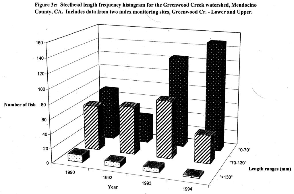
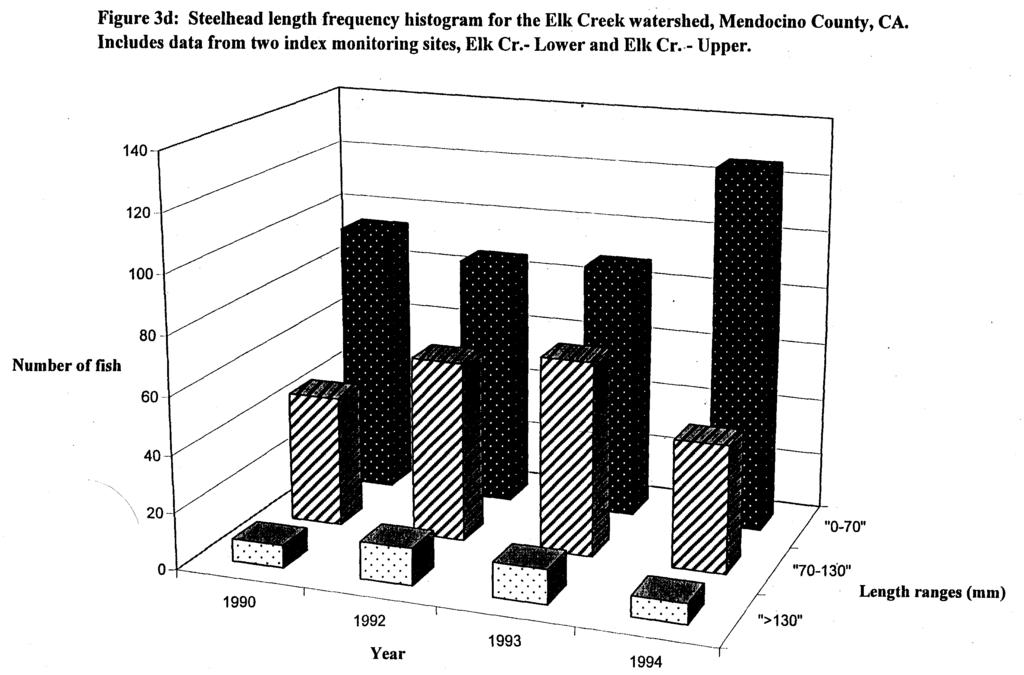
9 In , Gates Cr. - Upper and Lower were the only sites monitored in the Big River watershed. In 1990 and 1991, there were more steelhead in the 1+ age class than in the 0+ age class. This changed dramatically in 1992 and there continued to be 2-3 times more steelhead in the 0+ than in the 1+ age class with the addition of the Big Rv. and N. Fk. Big R. sites in 1993 and 1994 (Figure 3b). Steelhead biomass for both Gates Creek sites showed an overall increasing trend. At the Gates Cr. - Lower site biomass ranged from g/m 2 ( , respectively). Gates Cr. - Upper biomass ranged from g/m 2. Both Gates Creek sites had highs for years studied in regards to steelhead biomass numbers in 1993 (Gates Cr. -Lower, 5.3 g/m 2 and Gates Cr. - Upper, 3.9 g/m 2 ). Steelhead biomass at the Big Rv. site decreased from 2.6 g/m 2 in 1993 to 1.1 g/m 2 in At the N. Fk. Big R. site biomass increased slightly from 3.3 g/m 2 in 1993 to 3.4 g/m 2 in Six coho salmon were found at the N. Fk. Big R. site in 1993 with lengths ranging from mm). Coho biomass was 0.3 g/m 2 (Tables 3-7c). Figures 3c and 3d display the distribution of steelhead lengths for the Greenwood Creek and Elk Creek watersheds. Combined Lower and Upper sites in each of these watersheds had a higher percentage of 1+ steelhead than other monitored watersheds. Numbers of steelhead in the 1+ age class were 50-75% of those in the 0+ age class. For many years biomass showed an upward trend at all sites, with the exception of Greenwood Cr. - Upper, where biomass decreased significantly from 6.5 g/m 2 in 1990 to 2.6 g/m 2 in 1994 (Tables 3,4,5, and 7c). At the Elk Cr. - Lower site, biomass ranged from 0.3 g/m 2 in 1990 to 3.3 g/m 2 in Elk Cr. -Upper site was similar with biomass ranging from 0.4 g/m 2 (1990) g/m 2 (1994). Increases were not as great at the Greenwood Cr. - Lower site where biomass ranged from 1.9 g/m 2 (1990) g/m 2 (1994). Coho were present at both Elk Creek sites in 1992 only. Fifty coho were found at the Elk Cr. - Lower site ranging from mm. Biomass was 1.7 g/m 2 (Table 5c). At the Elk Creek - Upper site, five coho were found ranging in size from mm. Biomass was 0.2 g/m 2. In the Albion River watershed majorities of the steelhead for all survey years were comprised of the 0+ age class (Figure 3e). Numbers of steelhead in the 1+ age class were generally one-third to one-eighth of those in the 0+ age class. There were few (from 1-5) fish in the 2+ age class in each year. Coho salmon found in the Albion River watershed were mainly 0+ age class (Figure 3f). However, the disparity between 0+ and 1+ age class was not as apparent for coho as it was for steelhead. In several years there were more coho in the 1+ age class than the 0+. Tables 1-9c show biomass and length distributions for the Albion watershed. The Willow Creek watershed was the only monitored watershed from Sonoma County included in this report. An Upper and Lower site were electrofished from In 1990,1992, and 1993 the Willow Creek watershed had almost equal numbers of steelhead represented in the 0+ and 1+ age classes. The only year which had many more fish in the 0+ age class was 1991 (Figure 3g). Steelhead biomass at the Willow Cr. - Lower site increased from 1.4 g/m 2 in 1990 to 2.8 g/m 2 in 1993 (Tables 3-7c). This site was not monitored in At the Willow Cr. - Upper site, steelhead biomass decreased from 3.1 g/m 2 in 1990 to 0.8 g/m 2 in In 1994, biomass was up to a high of 4.3 g/m 2. Coho were found at the Willow Cr. - Upper site in 1990 only. Seventeen coho with lengths ranging from mm were found. Biomass was calculated as 1.3 g/m 2. DISCUSSION AND MANAGEMENT RECOMMENDATIONS The primary purpose of collecting salmonid density data in watersheds in Mendocino and Sonoma
10 Counties was to obtain baseline data for comparison of year-to-year trends in fish densities. This data will aid in pinpointing productive areas where habitat protection is a consideration and areas of concern where habitat restoration and improvement projects may prove beneficial. In the Garcia River watershed, coho salmon were found only in 1987 at the SF Garcia monitoring site. Density was calculated at 0.1 fish/m 2. This watershed was monitored until 1994 with no subsequent records of coho. Summary reports showed that surveys were done in 1988 and coho were found with a density of 0.5 fish/m 2, however, the Department of Fish and Game collected this data and data sheets were not available to validate reported densities. Because coho were not found in this watershed in succeeding years of survey, the area is key for further investigation and possible restoration projects. It should be noted that the California Department of Fish and Game planted approximately 30,000 juvenile coho salmon in the South Fork Garcia River on 16 May 1988 and spread 24,000 fish from Flemming Creek to the Mouth of South Fork Garcia on 24 May Plantings were done after electrofishing surveys were performed in Steelhead densities dropped overall in this watershed but were beginning to rise again in the last year of survey. Fish densities should be looked at again in this area as the last year of data was collected five years ago and steelhead densities were rising at that time. As a whole, steelhead densities in the Big River watershed showed stable or increasing numbers. Densities did rise and fall in Gates Creek; however, densities were higher in 1994 than in It would be necessary to perform more surveys at the Big River sites to determine any reliable trends as only two years of data were collected there. The NF Big Rv. site should be surveyed again to determine coho salmon presence or absence. The South Coast Area, Elk Creek in particular, is another area of concern for coho salmon. Coho were found in only one out of five years of survey (1992). Coho densities for 1992 were low, from 0.0 to 0.3 fish/m 2, indicating that progeny from the last three-year cycle were returning in very low numbers. In the years that correspond with 1992 returning coho, 1989 and 1995, no data exists for Elk Creek to determine life cycle trends. Elk Creek is a good candidate for further investigation. Steelhead densities in Elk Creek and Greenwood Creek have either remained stable or increased dramatically. Steelhead in these drainages also showed larger densities of 1+ and 2+ size class fish when compared to other areas. This might indicate that fish habitat conditions in these drainages are conducive to supporting overwintering fish. Habitat conditions should be surveyed in the future to quantify current habitat conditions. The Albion River watershed was the only catchement where coho salmon were found consistently enough to develop relationships of coho densities correlated with juvenile coho life cycle trends. It seems that progeny from the 1988 and 1990 year-class have returned with fairly stable or increasing densities. Progeny from the 1989 year-class did not fair as well with densities dropping dramatically in It is interesting to note that while coho salmon populations have remained stable or increased in the Albion, steelhead densities have demonstrated a downward trend at all sites in this watershed. This could be showing an inverse relationship between coho and steelhead densities. In Sonoma County, data from the Willow Creek watershed highlights another area of concern for coho salmon production. Although this watershed was surveyed for five years, coho were found only in 1990 at one monitoring site. In this case, fish from 1990 would be returning in 1993 and none were detected at either Willow Creek site during this year. Steelhead densities in this watershed generally seemed on an upward trend. The interrelations among salmonid fishes and their habitats are complex; habitat alterations, whether cause by natural processes or by human activities, can dramatically change the diversity and productivity
11 offish densities (Meehan 1991). Thus, it is important to monitor trends in fish densities and to use other available information on habitat, temperature, storm events, etc. while making management decisions involving fisheries resources. The data presented herein gives an overview of coho salmon and steelhead densities in Mendocino and Sonoma Counties (within MRC ownership), however; gaps exist in the data that make it less reliable and harder to draw conclusions from. Bagliniere and Champigneulle (1986) state that rational management of a migratory salmonid population in a drainage system requires a good knowledge of the juvenile population and the development of a method for estimating its production. A semi-quantitative electrofishing approach presented in Crozier and Kennedy (1994) can provide reliable information to fishery managers "on distribution of natural spawning in rivers. This approach is less time consuming than the quantitative approach described above and allows for more sampling sites spread throughout a watershed. The authors believe that semi-quantitative electrofishing would be advantageous in that 0+ numbers derived from surveys provide an indication of the success of spawning in various parts of a catchment as well as overall year-class strength. Kennedy (1981) also found that quantitative sampling of selected short sections of river (index sites) is sensitive to non-uniform distribution of 0+ salmonids and may provide misleading information on stock status as a whole. Semi-quantitative sampling, with the use of broad density classifications throughout a river system instead of point estimates should avoid the problem of non-uniform distribution of0+ salmonids (Crozier and Kennedy, 1994). Juvenile salmonid density data collected to date in Mendocino and Sonoma Counties is valuable to managers and should be continued and improved upon to provide a reliable source of information for making management decisions.
12 REFERENCES Bagliniere, J.L. and A. Champigneulle Population estimates of juvenile Atlantic salmon, Saimo salar, as indices of smolt production in the R. Scorff, Brittany. Journal of Fish Biology 29, Doloff, C. Andrew; Hankin, David G.; Reeves, Gordon H Basinwide estimation of habitat and fish populations in streams. Gen. Tech. Rep. SE-83. Asheville, NC: U.S. Department of Agriculture, Forest Service, Southeastern Forest Experiment Station. 25 pp. California Department of Fish and Game (CDFG) Stream Survey Field observations of Greenwood Creek watershed by CDFG warden Larry Redfem, Dave Netherby, and Kevin Rockwood. Everest, F.H Salmonids of western forested watersheds. In E.O. Salo and T.W. Cundy, editors. PP 3-8. Streamside Management: Forestry and Fisheries Interactions. Contr. No. 57, University of Washington, Institute of Forest Resources, Seattle, WA. Kennedy, G.J.A The reliability of quantitative juvenile salmon estimates using electrofishing techniques. Atlantic Salmon Trust Workshop on Data Acquisition, Windermere, 11 pp. Meehan, W. R., editor Influences of forest and rangeland management on salmonid fishes and their habitats. American Fisheries Society Special Publication 19. Mendocino County Resource Conservation District The Garcia River watershed enhancement plan. Report prepared for California Coastal Conservancy. Overton, S.W. and T.L. McDonald Draft: Regional estimation of fish abundance in streams. West Technical Report #98-5,24 pp. Van Denventer, J.S. and W. E. Platts A computer software system for entering, managing, and analyzing fish capture data from streams. U.S. For. Serv. Res. Note Int-352, Ogden, UT. 12 pp.
13 Table 1-a. Survey parameters offish index monitoring stations in the Albion River watershed, Mendocino Co., California. Summer and Fall [-] Indicates data not recorded. WATERSHED MONITORING STATION LOCATION MAPREF. (MONITORING SURVEY DATE SURVEY METHOD SURVEY EFFORT TOTAL STATION MEAN DEPTH SURFACE AREA(M 2 ) STATION REF.) MM/DD E=ELECTR (MIN.) LENGTH (M) 0- (M) FISHING; D=DIVER OBSVR. ALBION RIVER MAINSTEM ALBION R.- LOWER 1-C (ES-5) 08/22 E ALBION RIVER MAINSTEM ALBION R.- AT CONFLUENCE 1-C (ES-6) 08/23 E ALBION RIVER MAINSTEM ALBION R.- 1 Ml ABOVE CONFLUENCE 1-C (ES-7) 08/23 E ALBION RIVER S. FK. ALBION R.- ABOVE CONFLUENCE 1-C (ES-8) 08/23 E ALBION RIVER S. FK. ALBION R.- 1 Ml ABOVE CONFLUENCE 1-C (ES-9) 08/21 E ALBION RIVER S.FK. ALBION R.- NEAR LARMER GULCH 1-C (E8-10) 08/21 E ALBION RIVER RAILROAD GULCH 1-C (ES-11) 08/24 E
14 Table 1 -b. Number of fish taxa and observed and expected relative density of salmonids at fish index monitoring station^ in the Albion River watershed, Mendocino Co., California. Summer and Fall, [0.0] Indicates fish present in low abundance. MONITORING STATION LOCATION MONITORING STATION REF. NO. OF FISH TAXA OBSERVED RELATIVE DENSITY OF SALMONIDS (NO./ M2) EXPECTED RELATIVE DENSITY OF SALMONIDS (NO./M2) MAINSTEM ALBION R.- LOWER ES MAINSTEM ALBION R.- AT CONFLUENCE ES MAINSTEM ALBION R.- 1 Ml ABOVE CONFLUENCE ES S. FK. ALBION R.- ABOVE CONFLUENCE ES S. FK. ALBION R.- 1 Ml ABOVE CONFLUENCE ES S. FK. ALBION R.- NEAR LARMER GULCH ES RAILROAD GULCH ES SPECIES ABBREVIATION: =STEELHEAD TROUT; =O SALMON.
15 Table 1-c. Relative biomass and length distribution of salmonids at fish index monitoring stations in the Albion River watershed, Mendocino Co., California. Summer and Fall MONITORING STATION LOCATION MONITORING STATION REF. RELATIVE BIOMASS OF SALMONIDS (G WET MASS/M2) LENGTH DISTRIBUTION FOR SALMONIDS (MM) N (RANGE) MAINSTEM ALBION Ft.- LOWER ES (37-119) 33 (50-83) MAINSTEM ALBION R.- AT CONFLUENCE ES (46-177) 20 (55-85) MAINSTEM ALBION R.- 1 Ml ABOVE CONFLUENCE ES (53-144) 34 (55-72) S. FK. ALBION R.- ABOVE CONFLUENCE ES (47-77) 34 (52-70) S. FK. ALBION R.- 1 Ml ABOVE CONFLUENCE ES (41-101) 17 (49-69) S. FK. ALBION R.- NEAR LARMER GULCH ES (37-121) 73 (41-72) RAILROAD GULCH ES (41-102) 26 (45-65) SPECIES ABBREVIATION: =STEELHEAD TROUT; =O SALMON.
16 Table 2-a. Survey parameters of fish index monitoring stations in the Albion River watershed, Mendocino Co., California. Summer and Fall WATERSHED MONITORING STATION LOCATION MAP REF. (MONITORING STATION REF.) SURVEY DATE MM/DD SURVEY METHOD E=ELECTR 0-FISHING; D=DIVER OBSVR. SURVEY EFFORT (MIN.) TOTAL STATION LENGTH (M) MEAN DEPTH (M) SURFACE AREA(M 2 ) ALBION RIVER MAINSTEM ALBION R.- LOWER 1-C (ES-5) 08/22 E ALBION RIVER MAINSTEM ALBION R.- AT CONFLUENCE 1-C (ES-6) 08/23 E ALBION RIVER MAINSTEM ALBION R.- 1 Ml ABOVE CONFLUENCE 1-C (ES-7) 08/23 E ALBION RIVER S.FK. ALBION R.- ABOVE CONFLUENCE 1-C (ES-8) 08/23 E ALBION RIVER 8. FK. ALBION R.- 1 Ml ABOVE CONFLUENCE 1-C (ES-9) 08/21 E ALBION RIVER S.FK. ALBION R.- NEAR LARMER GULCH 1-C (ES-10) 08/21 E ALBION RIVER RAILROAD GULCH 1-C (ES-11) 08/24 E
17 Table 2-b. Number of fish taxa and observed and expected relative density of salmonids at fish index monitoring stations in the Albion River watershed, Mendocino Co., California. Summer and Fall [0.0] Indicates fish present in low abundance. MONITORING STATION LOCATION MONITORING STATION REF. NO. OF FISH TAXA OBSERVED RELATIVE DENSITY OF SALMONIDS (NO./M2) EXPECTED RELATIVE DENSITY OF SALMONIDS (NO./M2) MAINSTEM ALBION R.- LOWER ES MAINSTEM ALBION R.- AT CONFLUENCE ES MAINSTEM ALBION R.- 1 Ml ABOVE CONFLUENCE ES S.FK. ALBION R.- ABOVE CONFLUENCE ES S. FK. ALBION R.- 1 Ml ABOVE CONFLUENCE ES S. FK. ALBION R.- NEAR LARMER GULCH ES RAILROAD GULCH ES SPECIES ABBREVIATION: =STEELHEAD TROUT; =O SALMON
18 Table 2-c. Relative biomass and length distribution of salmonids at fish index monitoring stations in the Albion River watershed, Mendocino Co., California. Summer and Fall MONITORING STATION LOCATION MONITORING STATION REF. RELATIVE BIOMASS OF SALMONIDS (G WET MASS/M2) LENGTH DISTRIBUTION OF SALMONIDS (MM) N (RANGE) MAINSTEM ALBION R.- LOWER ES (32-158) 46(47-85) MAINSTEM ALBION R.- AT CONFLUENCE ES (41-151) 13(55-70) MAINSTEM ALBION R.- 1 Ml ABOVE CONFLUENCE ES (48-200) 7 (59-77) 8. FK. ALBION R.- ABOVE CONFLUENCE ES-S (33-123) 21(48-74) S. FK. ALBION R.- 1 Ml ABOVE CONFLUENCE ES (32-80) 8(56-70) S. FK. ALBION R.- NEAR LARMER GULCH ES (38-72) 25(53-112) RAILROAD GULCH ES (38-135) 2(58-64) SPECIES ABBREVIATION: =STEELHEAD TROUT; =O SALMON.
19 Table 3-a. Survey parameters of fish index monitoring stations in the Garcia River, Big River, Elk Creek, Greenwood Creek, and Albion River watersheds, Mendocino Co. and the Russian River watershed, Sonoma Co., California. Summer and Fall WATERSHED MONITORING STATION LOCATION MAP REF. (MONITORING STATION REF.) SURVEY DATE MM/DD SURVEY METHOD h=electr 0-FISHING; n=diver OBSVR. SURVEY EFFORT (MIN.) TOTAL' STATION LENGTH (M) MEAN WIDTH (M) MEAN DEPTH (M) GARCIA RIVER S. FK. GARCIA R.- BELOW FLEMMING CR. 1-F (ES-16) 09/27 E GARCIA RIVER FLEMMING CR.- ABOVE CONFLUENCE 1-F (ES-17) 09/26 E BIG RIVER GATES CR.- LOWER 1-B (ES-3) 09/20 E BIG RIVER GATES CR.- UPPER 1-B (ES-4) 09/20 E BIG RIVER BIG R.- WILDHORSE OPENING 1-A (ES-2) 09/15 E BIG RIVER N.FK.BIGR.- EAST BRANCH 1-A (ES-1) 09/14 E ELK CREEK ELKCR.- LOWER 1-E (ES-14) 08/23 E ELK CREEK ELKCR.- UPPER 1-E (ES-15) 08/23 E , GREENWOOD CREEK GREENWOOD CR.- LOWER 1-D (ES-12) 08/22 E GREENWOOD CREEK GREENWOOD CR.- UPPER 1-D (ES-13) 08/19 E ALBION RIVER MAINSTEM ALBION R.- LOWER 1-C (ES-5) 08/15 E ALBION RIVER MAINSTEM ALBION R.- AT CONFLUENCE 1-C (ES-6) 08/16 E ALBION RIVER MAINSTEM ALBION R.- 1MI ABOVE CONFLUENCE 1-C ES-7) 08/16 E ALBION RIVER S. FK. ALBION R.- ABOVE CONFLUENCE 1-C (ES-8) 08/17 E 24, ALBION RIVER S. FK. ALBION R.- 1MI ABOVE CONFLUENCE 1-C (ES-9) 08/17 E ALBION RIVER S. FK. ALBION R.- NEAR LARMER GULCH 1-C (ES-10) 08/17 E ALBION RIVER RAILROAD GULCH 1-C (ES-11) 08/18 E RUSSIAN RIVER WILLOW CR.- UPPER 1-G (ES-19) 09/28 E
20 Table 3-b. Number of fish taxa, and observed and expected relative density of salmonids at fish index monitoring stations in the Garcia River, Big River, Elk Creek, Greenwood Creek, and Albion River watersheds, Mendocino Co. and the Russian River watershed, Sonoma Co., California. Summer and fall, [0.0] Indicates fish present in low abundance. MONITORING STATION LOCATION MONITORING STATION REF. NO. OF FISH TAXA OBSERVED RELATIVE DENSITY OF SALMONIDS (NO./M2) EXPECTED RELATIVE DENSITY OF SALMONIDS (NO./M2) S. FK. GARCIA R.- BELOW FLEMMING CR. ES FLEMMING CR.- ABOVE CONFLUENCE ES GATES CR.- LOWER ES GATES CR.- UPPER ES BIG R.- WILDHORSE OPENING ES N.FK.BIGR.- EAST BRANCH ES ELKCR.- LOWER ES ELKCR.- UPPER ES GREENWOOD CR.- LOWER ES GREENWOOD CR.- UPPER ES MAINSTEM ALBION R.- LOWER ES MAINSTEM ALBION R.- AT CONFLUENCE ES MAINSTEM ALBION R.- 1MI ABOVE CONFLUENCE ES S. FK. ALBION R.- ABOVE CONFLUENCE ES S. FK. ALBION R.- 1MI ABOVE CONFLUENCE ES S. FK. ALBION R.- NEAR LARMER GULCH ES RAILROAD GULCH ES WILLOW CR.- UPPER ES SPECIES ABBREVIATION: =STEELHEAD TROUT; =O SALMON.
21 Table 3-c. Relative biomass and length distribution of salmonids at fish index monitoring stations in the Garcia River, Big River, Elk Creek, Greenwood Creek and Albion River watersheds, Mendocino Co., and the Russian River watershed, Sonoma Co., California. Summer and Fall MONITORING STATION LOCATION MONITORING STATION REF. RELATIVE BIOMASS OF SALMONIDS (G WET MASS/M2) S. FK. GARCIA R.- BELOW FLEMMING CR. ES (40-113) FLEMMING CR. ES (38-148) LENGTH DISTRIBUTION OF SALMONIDS (MM) MEDIAN (N, RANGE) GATES CR.- LOWER ES (39-153) GATES CR.- UPPER ES (40-183) BIG R.- WILDHORSE OPENING ES (47-175) N.FK.BIGR.- EAST BRANCH ES (43-168) ELKCR.- LOWER ES (40-173) ELKCR- UPPER ES (41-129) GREENWOOD CR.- LOWER ES (44-132) GREENWOOD CR.- UPPER ES (37-215) MAINSTEM ALBION R.- LOWER ES (33-141) 5(65-79) MAINSTEM ALBION R.- AT CONFLUENCE ES (36-153) 6(69-93) MAINSTEM ALBION R.- 1 Ml ABOVE CONFLUENCE ES (32-145) S. FK. ALBION R.- ABOVE CONFLUENCE ES-fl (55-98) 30(40-96) S. FK. ALBION R.- 1 Ml ABOVE CONFLUENCE ES (38-119) 1(80-80) S. FK. ALBION R.- NEAR LARMER GULCH ES (36-88) 35(62-95) RAILROAD GULCH ES (50-110) 1(83-83) WILLOW CR.- UPPER ES (42-142) SPECIES ABBREVIATION: =STEELHEAD TROUT; =O SALMON.
22 Table 4-a. Survey parameters offish index monitoring stations in the Garcia River, Big River, Elk Creek, Greenwood Creek, and Albion River watersheds, Mendocino Co., and the Russian River watershed, Sonoma Co., California. Summer and Fall [-] Indicates data not recorded. WATERSHED MONITORING STATION LOCATION MAP REF. (MONITORING STATION REF.) SURVEY DATE MM/DD SURVEY METHOD E=ELECTR 0-FISHING; D=DIVER OBSVR. SURVEY EFFORT (MIN.) TOTAL STATION LENGTH (M) MEAN WIDTH (M) MEAN DEPTH (M) GARCIA RIVER S. FK. GARCIA R.- BELOW FLEMMING CR. 1-F (ES-16) 11/22 E GARCIA RIVER FLEMMING CR.- ABOVE CONFLUENCE 1-F (ES-17) 11/22 E BIG RIVER GATES CR.- LOWER 1-B (ES-3) 10/06 E BIG RIVER GATES CR.- UPPER 1-B (ES-4) 10/06 E BIG RIVER BIG R.- WILDHORSE OPENING 1-A (ES-2) 10/13 E BIG RIVER N.FK.BIGR.- EAST BRANCH 1-A (ES-1) 10/12 E ELK CREEK ELKCR.- LOWER 1-E (ES-14) 09/30 E ELK CREEK ELKCR.- UPPER 1-E (ES-15) 09/23 E GREENWOOD CREEK GREENWOOD CR.- LOWER 1-D (ES-12) 09/29 E GREENWOOD CREEK GREENWOOD CR.- UPPER 1-D (ES-13) 09/22 E ALBION RIVER MAINSTEM ALBION R.- LOWER 1-C (ES-5) 08/18 E ALBION RIVER MAINSTEM ALBION R.- AT CONFLUENCE 1-C (ES-6) 08/19 E ALBION RIVER MAINSTEM ALBION R.- 1MI ABOVE CONFLUENCE 1-C (ES-7) 08/23 E ALBION RIVER S. FK. ALBION R.- ABOVE CONFLUENCE 1-C (ES-8) 08/20 E ALBION RIVER S. FK. ALBION R.- 1 Ml ABOVE CONFLUENCE 1-C (ES-9) 08/30 E ALBION RIVER S. FK. ALBION R.- NEAR LARMER GULCH 1-C (ES-10) 08/30 E ALBION RIVER RAILROAD GULCH 1-C (ES-11) 09/02 E RUSSIAN RIVER WILLOW CR.- LOWER 1-G (ES-18) 11/11 E RUSSIAN RIVER WILLOW CR.- UPPER 1-G (ES-19) 11/11 E
23 Table 4-b. Number of fish taxa, and observed and expected relative density of salmonids at fish index monitoring stations in the Garcia River, Big River, Elk Creek, Greenwood Creek, and Albion River v Mendocino Co., and the Russian River watershed, Sonoma Co., California. Summer and Fall MONITORING STATION LOCATION MONITORING STATION REF. NO. OF FISH TAXA OBSERVED RELATIVE DENSITY OF SALMONIDS (NO./M2) EXPECTED RELATIVE DENSITY OF SALMONIDS (NO./M2) S.FK. GARCIA R.- BELOW FLEMMING CR. ES FLEMMING CR.- ABOVE CONFLUENCE ES GATES CR.- LOWER ES GATES CR.- UPPER ES BIG R.- WILDHORSE OPENING ES N.FK.BIGR.- EAST BRANCH ES ELKCR.- LOWER ES ELKCR.- UPPER ES GREENWOOD CR.- LOWER ES GREENWOOD CR.- UPPER ES MAINSTEM ALBION- LOWER ES MAINSTEM ALBION- AT CONFLUENCE ES MAINSTEM ALBION- 1 Ml ABOVE CONFLUENCE ES S, FK. ALBION- ABOVE CONFLUENCE ES S. FK. ALBION- 1 Ml ABOVE CONFLUENCE ES S. FK. ALBION- NEAR LARMER GULCH ES RAILROAD GULCH ES WILLOW CR.- LOWER ES WILLOW CR.- UPPER ES-19 \ SPECIES ABBREVIATION: =STEELHEAD TROUT; =O SALMON; CHK=CHINOOK SALMON; CTT=CUTTROAT TROUT.
24 Table 4-c. Relative biomass and length distribution of salmonids at fish index monitoring stations in the Garcia River, Big River, Elk Creek, Greenwood Creek, and Albion River watersheds, Mendocino Co., and the Russian River watershed, Sonoma Co., California. Summer and Fall MONITORING STATION LOCATION MONITORING STATION REF. RELATIVE BIOMASS OF SALMONIDS (G WET MASS/M2) LENGTH DISTRIBUTION OF SALMONIDS (MM) N (RANGE) S. FK. GARCIA R.- BELOW FLEMMING CR. ES-16 1,6 61 (47-100) FLEMMING CR.- ABOVE CONFLUENCE ES (45-198) GATES CR.- LOWER ES (52-138) GATES CR.- UPPER ES (53-167) BIG R.- WILDHORSE OPENING ES (56-170) N.FK.BIGR.- EAST BRANCH ES (49-160) 6(63-73) ELKCR.- LOWER ES-14 3,4 84 (43-143) ELKCR.- UPPER ES (59-175) GREENWOOD CR.- LOWER ES (60-178) GREENWOOD CR.- UPPER ES (46-184) MAINSTEM ALBION R.- LOWER ES-5 1, (39-133) 51(50-84) MAINSTEM ALBION R.- AT CONFLUENCE ES (37-108) 41(51-86) MAINSTEM ALBION R.- 1 Ml ABOVE CONFLUENCE ES (49-85) 8(54-80) S.FK. ALBION R.- ABOVE CONFLUENCE ES (44-94) 35(47-73) S. FK. ALBION R.- 1 Ml ABOVE CONFLUENCE ES (37-108) 36(49-70) S. FK. ALBION R.- NEAR LARMER GULCH ES (39-125) 83(40-97) RAILROAD GULCH,ES (46-158) 13(52-68) / WILLOW CR.- LOWER / ES (49-165) WILLOW CR.- UPPER ES (55-98) SPECIES ABBREVIATION: =STEELHEAD TROUT; =O SALMON.
25 Table 5-a. Survey parameters of fish index monitoring stations in the Garcia River, Big River, Elk Creek, Greenwood Creek, and Albion River watersheds, Mendocino Co., and the Russian River watershed, Sonoma Co., California. Summer and Fall [-] Indicates data not recorded. WATERSHED MONITORING STATION LOCATION MAPREF. (MONITORING STATION REF.) SURVEY DATE MM/DD SURVEY METHOD E=ELECTR 0-FISHING; D=DIVER OBSVR. SURVEY EFFORT (MIN.) TOTAL STATION LENGTH (M) MEAN WIDTH (M) MEAN DEPTH (M) GARCIA RIVER FLEMMING CR.- ABOVE CONFLUENCE 1-F (ES-17) 10/28 E BIG RIVER GATES CR.- LOWER 1-B (ES-3) 10/09 E BIG RIVER GATES CR.- UPPER 1-B (ES^t) 10/09 E ELK CREEK ELK CR.-LOWER 1-E (ES-14) 9/01 E ELK CREEK ELK CR.-UPPER 1-E (ES-15) 9/01 E GREENWOOD CREEK GREENWOOD CR.- LOWER 1-D (ES-12) 09/04 E GREENWOOD CREEK GREENWOOD CR.- UPPER 1-D (ES-13) 09/10 E ALBION RIVER MAINSTEM ALBION R.- LOWER 1-C (ES-5) 08/19 E ALBION RIVER MAINSTEM ALBION R.- AT CONFLUENCE 1-C (ES-6) 07/31 E ALBION RIVER MAINSTEM ALBION R.- 1 Ml ABOVE CONFLUENCE 1-C (ES-7) 08/18 E ALBION RIVER S.FK. ALBION R.- ABOVE CONFLUENCE 1-C (ES-8) 07/31 E ALBION RIVER S. FK. ALBION R.- 1MI ABOVE CONFLUENCE 1-C (ES-9) 08/18 E ALBION RIVER S. FK. ALBION R.- NEAR LARMER GULCH 1-C (ES-10) 08/18 E ALBION RIVER RAILROAD GULCH 1-C (ES-11) 06/19 E RUSSIAN RIVER WILLOW CR.- LOWER 1-G (ES-18) 11/10 E
26 Table 5-b. Number of fish taxa, and observed and expected relative density of salmonids at fish index monitoring stations in the Garcia River, Big River, Elk Creek, Greenwood Creek, and Albion River watersheds, Mendocino Co., And the Russian River watershed, Sonoma Co., California. Summer and Fall MONITORING STATION LOCATION MONITORING STATION REF. NO. OF FISH TAXA OBSERVED RELATIVE DENSITY OF SALMONIDS (NO./M2) EXPECTED RELATIVE DENSITY OF SALMONIDS (NO./ M2) FLEMMING CR.- ABOVE CONFLUENCE ES GATES CR.- LOWER ES GATES CR.- UPPER ES ELK CR.-LOWER ES NO DATA NODATA ELK CR.-UPPER ES NO DATA NODATA GREENWOOD CR.- LOWER ES GREENWOOD CR.- UPPER ES MAINSTEM ALBION R.- LOWER ES MAINSTEM ALBION R.- AT CONFLUENCE ES MAINSTEM ALBION R.- 1 Ml ABOVE CONFLUENCE ES S. FK. ALBION R.- ABOVE CONFLUENCE ES S. FK. ALBION R.- 1 Ml ABOVE CONFLUENCE ES S. FK. ALBION R.- NEAR LARMER GULCH ES RAILROAD GULCH ES ,7 WILLOW CR.- LOWER ES SPECIES ABBREVIATION: =STEELHEAD TROUT; =O SALMON.
27 Table 5-c. Relative biomass and length distribution of salmonids at fish population index stations in the Garcia River, Big River, Elk Creek, Greenwood Creek, and Albion River watersheds, Mendocino Co., and the Russian River watershed, Sonoma Co., California. Summer and Fall MONITORING STATION LOCATION MONITORING STATION REF. RELATIVE BIOMASS OF SALMONIDS (G WET MASS/M2) LENGTH DISTRIBUTION OF SALMONIDS (MM) N (RANGE.) FLEMMINGCR.- ABOVE CONFLUENCE ES (42-153) - GATES CR.- LOWER ES (46-176) - GATES CR.- UPPER ES-4 0,9-15(41-113) - ELK CR.-LOWER ES-14 5, (31-176) 50(63-84) ELK CR.-UPPER ES (40-179) 5(72-75) GREENWOOD CR.- LOWER ES (57-140) - GREENWOOD CR.- UPPER ES (54-165) - MAINSTEM ALBION R.- LOWER ES (42-165) 70(44-79) MAINSTEM ALBION R.- AT CONFLUENCE ES (47-120) 39 (48-77) MAINSTEM ALBION R.- 1 Ml ABOVE CONFLUENCE ES (38-108) 25(45-65) S. FK. ALBION R.- ABOVE CONFLUENCE ES (38-167) 77(41-74) S. FK. ALBION R.- 1 Ml ABOVE CONFLUENCE ES (39-100) 33(43-68) S. FK. ALBION R.- NEAR LARMER GULCH ES (36-134) 69(40-127) RAILROAD GULCH ES-11 2,4-32(33-135) - WILLOW CR.- LOWER ES-18 1,5-17(55-145) - SPECIES ABBREVIATION: =STEELHEAD TROUT; =O SALMON.
28 Table 6-a. Survey parameters of fish index monitoring stations in the Big River and Albion River watersheds, Mendocino Co., and the Russian River watershed, Sonoma Co., California. Summer and Fall (-] indicates data not recorded. WATERSHED MONITORING STATION LOCATION MAPREF. (MONITORING STATION REF.) SURVEY DATE MM/DD SURVEY METHOD E=ELECTR 0-FISHING; D=DIVER OBSVR. SURVEY EFFORT (MIN.) TOTAL STATION LENGTH (M) MEAN WIDTH (M) MEAN DEPTH (M) BIG RIVER GATES CR.- LOWER 1-B (ES-3) 11/15 E BIG RIVER GATES CR.- UPPER 1-B (ES-4) 11/15 E ALBION RIVER MAINSTEM ALBION R.- LOWER 1-C (ES-5) 07/15 E ALBION RIVER MAINSTEM ALBION R.- AT CONFLUENCE 1-C (ES-6) 07/15 E ALBION RIVER MAINSTEM ALBION R.- 1MI ABOVE CONFLUENCE 1-C (ES-7) 07/16 E ALBION RIVER S.FK. ALBION R.- ABOVE CONFLUENCE 1-C (ES-8) 07/15 E ALBION RIVER S. FK. ALBION R.- 1 Ml ABOVE CONFLUENCE 1-C (ES-9) 07/16 E ALBION RIVER S. PK. ALBION R.- NEAR LARMER GULCH 1-C (ES-10) 07/18 E ALBION RIVER RAILROAD GULCH 1-C (ES-11) 07/01 E RUSSIAN RIVER WILLOW CR.- LOWER 1-G (ES-18) 09/14 E RUSSIAN RIVER WILLOW CR- UPPER 1-G (ES-19) 09/13 E
29 Table 6-b. Number of fish taxa, and observed and expected relative density of salmonids at fish index monitoring stations in the Big River and Albion River watersheds, Mendocino Co., and the Russian River watershed, Sonoma Co., California. Summer and Fall [0.0] Indicates fish present in low abundance. MONITORING STATION LOCATION MONITORING STATION REF. NO. OF FISH TAXA OBSERVED RELATIVE DENSITY OF SALMONIDS (NO./ M2) EXPECTED RELATIVE DENSITY OF SALMONIDS (NO./M2) GATES CR.- LOWER ES ,5 GATES CR.- UPPER ES MAINSTEM ALBION R.- LOWER ES MAINSTEM ALBION R.- AT CONFLUENCE ES MAINSTEM ALBION R.- 1 Ml ABOVE CONFLUENCE ES ,3 S.FK. ALBION R.- ABOVE CONFLUENCE ES ,4 S. FK. ALBION R.- 1 Ml ABOVE CONFLUENCE ES S. FK ALBION R.- NEAR LARMER GULCH ES RAILROAD GULCH ES WILLOW CR.- LOWER ES WILLOW CR.- UPPER ES SPECIES ABBREVIATION: =STEELHEAD TROUT; =O SALMON.
30 Table 6-c. Relative biomass and length distribution of salmonids at fish index monitoring stations in the Big River and Albion River watersheds, Mendocino Co., and the Russian River watershed, Sonoma Co., California. Summer and Fall MONITORING STATION LOCATION MONITORING STATION REF. RELATIVE BIOMASS OF SALMONIDS (G WET MASS/M2) LENGTH DISTRIBUTION OF SALMONIDS (MM) N(RANGE) GATES CR.- LOWER ES (55-170) GATES CR.- UPPER ES (55-135) MAINSTEM ALBION R.- LOWER ES (43-149) 4(70-75) MAINSTEM ALBION R.- AT CONFLUENCE ES (37-104) MAINSTEM ALBION R.- 1 Ml ABOVE CONFLUENCE ES (40-115) S.FK. ALBION R.- ABOVE CONFLUENCE ES (40-88) S. FK. ALBION R.- 1MI ABVOE CONFLUENCE ES (40-72) S. FK. ALBION R.- NEAR LARMER GULCH ES (36-56) 8(80-114) RAILROAD GULCH ES (31-125) WILLOW CR.- LOWER ES (55-135) WILLOW CR.- UPPER ES ( ) SPECIES ABBREVIATION: =STEELHEAD TROUT; =O SALMON.
31 Table 7-a. Survey parameters offish population index stations in the Big River, Elk Creek, Greenwood Creek, and Albion River watersheds, Mendocino Co., and the Russian River watershed, Sonoma Co. California. Summer and Fall (-] Indicates data not recorded. WATERSHED MONITORING STATION LOCATION MAPREF. (MONITORING STATION REF.) SURVEY DATE MM/DD SURVEY METHOD E=ELECTR 0-FISHING; D=DIVER OBSVR. SURVEY EFFORT (MIN.) TOTAL STATION LENGTH (M) MEAN WIDTH (M) MEAN DEPTH (M) BIG RIVER GATES CR.- LOWER 1-B (ES-3) 11/16 E BIG RIVER GATES CR.- UPPER 1-B (ES-4) 11/16 E ELK CREEK ELK CR.-LOWER 1-E(ES-14) 09/06 E ELK CREEK ELK CR.-UPPER 1-E(ES-15) 09/25 E GREENWOOD CREEK GREENWOOD CR.- LOWER 1-D (ES-12) 10/17 E GREENWOOD CREEK GREENWOOD CR.- UPPER 1-D (ES-13) 10/16 E ALBION RIVER MAINSTEM ALBION R.- AT CONFLUENCE 1-C (ES-6) 11/07 E ALBION RIVER MAINSTEM ALBION R.- 1MI ABOVE CONFLUENCE 1-C (ES-7) 11/12 E ALBION RIVER S. FK. ALBION R.- ABOVE CONFLUENCE 1-C (ES-8) 11/07 E ALBION RIVER S. FK. ALBION R.- 1MI ABOVE CONFLUENCE 1-C (ES-9) 11/12 E ALBION RIVER RAILROAD GULCH 1-C (ES-11) 06/08 E RUSSIAN-RIVER WILLOW CR.- LOWER 1-G (ES-18) 10/06 E RUSSIAN RIVER WILLOW CR.- UPPER 1-G (ES-19) 10/05 E
32 Table 7-b. Number of fish taxa, and observed and expected relative density of salmonids at fish index monitoring stations in the Big River, Elk Creek, Greenwood Creek, and Albion River watersheds, Mendocino Co., and the Russian River watershed, Sonoma Co., California. Summer and Fall [0.0] Indicates fish present in low abundance. MONITORING STATION LOCA TION MONITORING STATION REF. NO. OF FISH TAXA OBSERVED RELATIVE DENSITY OF SALMONIDS (NO./M2) EXPECTED RELATIVE DENSITY OF SALMONIDS (NO./M2) GATES CR.- LOWER ES GATES CR.- UPPER ES ELK CR.-LOWER ES NO DATA ELK CR.-UPPER ES NO DATA GREENWOOD CR.- LOWER ES GREENWOOD CR.- UPPER ES MAINSTEM ALBION- AT CONFLUENCE ES MAINSTEM ALBION- 1MI ABOVE CONFLUENCE ES S. FK ALBION- ABOVE CONFLUENCE ES S.FK. ALBION- 1MI ABOVE CONFLUENCE ES INDEX STATION- RAILROAD GULCH ES WILLOW CR.- LOWER ES WILLOW CR.- UPPER ES SPECIES ABBREVIATION: =STEELHEAD TROUT; =O SALMON.
33 Table 7-c. Relative biomass and length distribution of salmonids at fish index monitoring stations in the Big River, Elk Creek, Greenwood Creek, and Albion River watersheds, Mendocino Co., and the Russian River watershed, Sonoma Co., California. Summer and Fall MONITORING STATION LOCATION MONITORING STATION REF. RELATIVE BIOMASS OF SALMONIDS (G WET MASS/M2) LENGTH DISTRIBUTION OF SALMONIDS (MM) N (RANGE) GATES CR.- LOWER ES (55-120) GATES CR.- UPPER ES (65-125) ELK CR.-LOWER ES (46-167) ELK CR.-UPPER ES (52-170) GREENWOOD CR.- LOWER ES (58-147) GREENWOOD CR.- UPPER ES (54-220) MAINSTEM ALBION R.- AT CONFLUENCE ES (42-159) 2(78-96) MAINSTEM ALBION R.- 1 Ml ABOVE CONFLUENCE ES (39-63) 2(79-91) S. FK. ALBION R.- ABOVE CONFLUENCE ES (45-103) S. FK. ALBION R.- 1MI ABOVE CONFLUENCE ES (48-75) RAILROAD GULCH ES (40-151) 8(68-83) WILLOW CR.- LOWER ES (60-130) WILLOW CR.- UPPER ES (55-135) 17(52-70) SPECIES ABBREVIATION: =STEELHEAD TROUT; =O SALMON.
34 Table 8-a. Survey parameters of fish population index stations in the Albion River watershed, Mendocino Co., California. Spring 1989 and (-] Indicates data not recorded. WATERSHED MONITORING STATION LOCATION MAP REF. SURVEY SURVEY SURVEY TOTAL MEAN MEAN (MONITORING DATE METHOD EFFORT STATION WIDTH DEPTH STATION REF./ MM/DD E=ELECTR (MIN.) LENGTH (M) (M) YEAR) 0- (M) FISHING; D=DIVER OBSVR. ALBION RIVER MAINSTEM ALBION R.- AT CONFLUENCE 1-C (ES-6/89) 06/15 E ALBION RIVER S. FK. ALBION R.- ABOVE CONFLUENCE 1-C (ES-8/89) 06/15 E ALBION RIVER RAILROAD GULCH 1-C (ES-1/89) 05/25 E ALBION RIVER RAILROAD GULCH 1-C (ES-11/88) 05/19 E Table 8-b. Number offish taxa, and observed and expected relative density of salmonids at fish index monitoring stations in the Albion River watershed, Mendocino Co., California. Spring 1989 and MONITORING STATION LOCATION MONITORING STATION REF./ YEAR NO. OF FISH TAXA OBSERVED RELATIVE DENSITY OF SALMONIDS (NO./M2) EXPECTED RELATIVE DENSITY OF SALMONIDS (NO./M2) MAINSTEM ALBION R.- AT CONFLUENCE ES-6/ S.FK. ALBION R.- ABOVE CONFLUENCE ES-8/ RAILROAD GULCH ES-11/ RAILROAD GULCH ES-11/ SPECIES ABBREVIATION: =STEELHEAD TROUT; =O SALMON.
35 Table 8-c. Relative biomass and length distribution of salmonids at fish index monitoring stations in the Albion River watershed, Mendocino Co., California. Spring 1989 and MONITORING STATION LOCATION MONITOR ING STATION REF./YEAR RELATIVE BIOMASS OF SALMONIDS (G WET MASS/ M2) LENGTH DISTRIBUTION OF SALMONIDS (MM) N (RANGE) MAINSTEM ALBION R.- AT CONFLUENCE ES-6/ (47-142) 57(32-68) S. FK. ALBION R.- ABOVE CONFLUENCE ES-8/ (33-114) 32(37-65) RAILROAD GULCH ES-11/ (30-125) 43(38-74) RAILROAD GULCH ES-11/ (62-95) 73(35-71) WECIES ABBREVIATION: =STEELHEAD TROUT; =O SALMON.
36 Table 9-a. Survey parameters of fish index monitoring stations in the Garcia River watershed, Mendocino Co., California. Summer [-] Indicates data not recorded. WATERSHED MONITORING STATION LOCATION MAP REF. SURVEY SURVEY SURVEY TOTAL MEAN MEAN (MONITORING DATE METHOD EFFORT STATION WIDTH DEPTH STATION REF./ MM/DD E=ELECTR (MIN.) LENGTH (M) (M) YEAR) 0- (M) FISHING; D=DIVER OBSVR. GARCIA RIVER S. FK. GARCIA R. - BELOW FLEMMING CR. 1-F(ES-16) 08/17 E GARCIA RIVER FLEMMING CR. -ABOVE CONFLUENCE 1-F (ES-17) 08/17 E Table 9-b. Number of fish taxa, and observed and expected relative density of salmonids at fish index monitoring stations in the Garcia River watershed, Mendocino Co., California. Summer MONITORING STATION LOCATION MONITORING STATION REF./ YEAR NO. OF FISH TAXA OBSERVED RELATIVE DENSITY OF SALMONIDS (NO./M2) EXPECTED RELATIVE DENSITY OF SALMONIDS (NO./M2) S. FK. GARCIA R. - BELOW FLEMMING CR. ES-16/ NO DATA FLEMMING CR, -ABOVE CONFLUENCE ES-17/ NO DATA NO DATA SPECIES ABBREVIATION: =STEELHEAD TROUT; =O SALMON Table 9-c. Relative biomass and length distribution of salmonids at fish population index stations in the Garcia River watershed, Mendocino Co., California. Summer MONITORING STATION LOCATION MONITORING STATION REF./YEAR RELATIVE BIOMASS OF SALMONIDS (G WET MASS/M2) LENGTH DISTRIBUTION OF SALMONIDS (MM) N (RANGE) S. FK. GARCIA R. - BELOW FLEMMING CR. ES-16/ (35-130) 10(58-73) FLEMMING CR. - ABOVE CONFLUENCE ES-17/ (31-112) SPECIES ABBREVIA TION: =STEELHEAD TROUT; =O SALMON.
37
38
39
40
41
42
43
44
45
46
47
Abundance of Steelhead and Coho Salmon in the Lagunitas Creek Drainage, Marin County, California
 scanned for KRIS Abundance of Steelhead and Coho Salmon in the Lagunitas Creek Drainage, Marin County, California Prepared for: Marin Municipal Water District 220 Nellen Drive Corte Madera, California
State of San Francisco Bay 2011 Appendix O Steelhead Trout Production as an Indicator of Watershed Health
 State of San Francisco Bay 2011 Appendix O Steelhead Trout Production as an Indicator of Watershed Health Gordon Becker and Katherine Smetak, Center for Ecosystem Management and Restoration 290 Introduction
SECTION F FISH HABITAT CONDITION AND AQUATIC SPECIES DISTRIBUTION
 SECTION F FISH HABITAT CONDITION AND AQUATIC SPECIES DISTRIBUTION INTRODUCTION The fish species currently inhabiting the Gualala River WAU are steelhead trout (Oncorhynchus mykiss), sculpin (Cottus spp.),
1998 Willow Creek Downstream Migrant Trap Report. Draft. Prepared By: C. A. Walker. Lower Trinity Ranger District. Six Rivers National Forest
 1998 Willow Creek Downstream Migrant Trap Report Draft Prepared By: C. A. Walker Lower Trinity Ranger District Six Rivers National Forest September 1998 Executive Summary The downstream migrant trap was
Data Report : Russian River Basin Steelhead and Coho Salmon Monitoring Program Pilot Study
 Data Report 1999-1: Russian River Basin Steelhead and Coho Salmon Monitoring Program Pilot Study Sonoma County Water Agency 215 West College Avenue Santa Rosa, California 951 Prepared by David Cook Senior
California Steelhead: Management, Monitoring and Recovery Efforts
 California Steelhead: Management, Monitoring and Recovery Efforts Jonathan Nelson Steelhead Restoration & Management Program Oncorhynchus mykiss irideus California Steelhead Distinct Population Segments
Job 1. Title: Estimate abundance of juvenile trout and salmon.
 STUDY PERFORMANCE REPORT State: Michigan Project No.: F-53-R-13 Study No.: 461 Title: Population dynamics of juvenile rainbow trout and coho salmon in Lake Superior tributaries Period Covered: April 1,
ELECTRO-FISHING REPORT 2016 UPPER TWEED
 ELECTRO-FISHING REPORT 2016 UPPER TWEED The electro-fishing programme carried out each summer by The Tweed Foundation is part of our management plan, which details the information that is required to manage
THE OREGON PLAN for. Salmon and Watersheds. Smith River Steelhead and Coho Monitoring Verification Study, Report Number: OPSW-ODFW
 THE OREGON PLAN for Salmon and Watersheds Smith River Steelhead and Coho Monitoring Verification Study, 2007 Report Number: OPSW-ODFW-2009-11 The Oregon Department of Fish and Wildlife prohibits discrimination
BOGUS CREEK SALMON STUDIES 2002
 BOGUS CREEK SALMON STUDIES 2002 BY: JEANNINE RICHEY California Department of Fish and Game KLAMATH RIVER PROJECT 303 SOUTH STREET YREKA, CALIFORNIA 96097 (530) 842-3109 California Department of Fish and
San Lorenzo Valley Water District, Watershed Management Plan, Final Version Part I: Existing Conditions Report
 LIST OF FIGURES Figure 1-1. Map of the San Lorenzo River watershed Figure 2-1. The Santa Cruz Mountains Bioregion Figure 2-2. Protected areas within the San Lorenzo River watershed Figure 2-3. Primary
Summer Steelhead Surveys North Fork Trinity River Trinity County, California
 KRIS edition Summer Steelhead Surveys North Fork Trinity River Trinity County, California 1978-1997 By Loren Everest Fishery Biologist Weaverville Ranger District Shasta-Trinity National Forests October
OREGON DEPARTMENT OF FISH AND WILDLIFE ROGUE FISH DISTRICT REPORT
 OREGON DEPARTMENT OF FISH AND WILDLIFE ROGUE FISH DISTRICT REPORT TITLE: Upper Rogue Smolt Trapping Project, 1999 STREAM: Big Butte, Little Butte, South Fork Big Butte, Slate and West Fork Evans Creeks
Redd Dewatering and Juvenile Salmonid Stranding in the Lower Feather River,
 Redd Dewatering and Juvenile Salmonid Stranding in the Lower Feather River, 2005-2006 Interim Report for NOAA Fisheries Prepared by: California Department of Water Resources Division of Environmental Services
Study Update Fish Distribution and Species Composition
 Study Update Fish Distribution and Species Composition Goals and Study Area Gain a better understanding of fish species composition and abundance in waters associated with the Packwood Lake Hydroelectric
Executive Summary. Map 1. The Santa Clara River watershed with topography.
 Santa Clara River Steelhead Trout: Assessment and Recovery Opportunities December 2005 Prepared By: Matt Stoecker and Elise Kelley, Ph.D. University of California, Santa Barbara Prepared For: The Santa
Michigan Department of Natural Resources Status of the Fishery Resource Report Page 1
 Michigan Department of Natural Resources 2008-59 Status of the Fishery Resource Report Page 1 Bowens Manistee County, (T24N R16W Sec. 11, 12, 13, 14, 15, 24, and 30). Last surveyed 2008 Mark A. Tonello
Cemetery Creek Smolt Trap Data Summary What is a smolt? What is a smolt trap? Cemetery Creek Smolt Trap Data:
 Cemetery Creek Smolt Trap Data Summary What is a smolt? A "smolt" is one of the life stages of a juvenile salmon. This life stage occurs when the juvenile salmon begins its migration from freshwater to
Southern Oregon Coastal Cutthroat Trout
 Species Management Unit Description Southern Oregon Coastal Cutthroat Trout The Southern Oregon Coastal Cutthroat Trout SMU includes all populations of cutthroat trout inhabiting ocean tributary streams
Oregon Coast Coastal Cutthroat Trout
 Oregon Coast Coastal Cutthroat Trout Species Management Unit Description The Oregon Coast Coastal Cutthroat Trout Species Management Unit (SMU) includes all populations of cutthroat trout inhabiting ocean
STEELHEAD SURVEYS IN OMAK CREEK
 STEELHEAD SURVEYS IN OMAK CREEK 2002 Annual Report Prepared by Chris Fisher John Arterburn Colville Confederated Tribes Fish and Wildlife Department P.O. Box 150 Nespelem, WA 99155 Prepared for Project
Study Update Tailrace Slough Use by Anadromous Salmonids
 Study Update Tailrace Slough Use by Anadromous Salmonids Goals and Objectives Identify what anadromous salmonids use the tailrace slough by: Life Stage (Juvenile, migrating and spawning adults) Timing
STUDY PERFORMANCE REPORT
 STUDY PERFORMANCE REPORT State: Michigan Project No.: F-80-R-7 Study No.: 230654 Title: Evaluation of brown trout and steelhead competitive interactions in Hunt Creek, Michigan. Period Covered: October
3. The qualification raised by the ISRP is addressed in #2 above and in the work area submittal and review by the ISRP as addressed in #1.
 Please find attached a response from The Confederated Tribes of the Warm Springs Reservation of Oregon (CTWSRO) for Project # 2008-301-00, Habitat Restoration Planning, Design and Implementation within
Blue Creek Chinook Outmigration Monitoring Technical Memorandum
 Blue Creek Chinook Outmigration Monitoring 2012 Technical Memorandum Prepared by: Andrew Antonetti and Erika Partee Yurok Tribe Fisheries Program PO Box 1027 Klamath, California 95548 In Partnership with:
2013 Electrofishing Program Summary. Miramichi Salmon Association In collaboration with the Department of Fisheries and Oceans
 2013 Electrofishing Program Summary Miramichi Salmon Association In collaboration with the Department of Fisheries and Oceans Prepared by: Alex Parker Biologist Miramichi Salmon Association 485, Route
Fish Habitat Restoration and Monitoring in Southeast Washington. Andy Hill Eco Logical Research, Inc.
 Fish Habitat Restoration and Monitoring in Southeast Washington Andy Hill Eco Logical Research, Inc. Fish Habitat Restoration and Monitoring in Southeast Washington Talk overview: Restoration projects
STREAM SURVEY File form No..
 scanned for KRIS THE RESOURCES AGENCY OF CALIFORNIA California Department of Fish and Game STREAM SURVEY File form No.. Date: September 4, 1969. NAME: North Fork Schooner Gulch Creek COUNTY: Mendocino.
Downstream Migrant Trapping in Russian River Mainstem, Tributaries, and Estuary
 Downstream Migrant Trapping in Russian River Mainstem, Tributaries, and Estuary Introduction In September 2008, the National Marine Fisheries Service issued the Russian River Biological Opinion, which
A.23 RIVER LAMPREY (LAMPETRA
 A. RIVER LAMPREY (LAMPETRA AYRESII) A.. Legal and Other Status The river lamprey is a Class (Watch List) California Species of Special Concern (Moyle et al., DFG 0). It has no federal status. A.. Species
Warden Tom Kasnick August 30, 1983
 scanned for KRIS Franz Creek Warden Tom Kasnick August 30, 1983 - Region 3 Franz Creek, Sonoma County - Fish Kill and Pollution Incident On August 3, 1983, you requested that I investigate a reported fish
California Steelhead: Management, Monitoring and Recovery Efforts
 California Steelhead: Management, Monitoring and Recovery Efforts Jonathan Nelson Steelhead Management, Research and Restoration Program Oncorhynchus mykiss irideus California Steelhead - Hot Topics Implementation
Downstream Migrant Trapping in Russian River Mainstem, Tributaries, and Estuary
 Downstream Migrant Trapping in Russian River Mainstem, Tributaries, and Estuary Introduction In September 2008, the National Marine Fisheries Service issued the Russian River Biological Opinion, which
Olema Creek Watershed and
 Olema Creek Watershed and Cheda Creek Fish Surveys The objectives of this limited survey were several. First, we wanted to qualitatively assess changes in fish species composition and relative abundance
The Effects of Stream Adjacent Logging on Downstream Populations of Coastal Cutthroat Trout
 The Effects of Stream Adjacent Logging on Downstream Populations of Coastal Cutthroat Trout. D. S. Bateman 1, R.E. Gresswell 2, Aaron M. Berger 3, D.P. Hockman-Wert 4 and D.W. Leer 1 1 Department of Forest
5B. Management of invasive species in the Cosumnes and Mokelumne River Basins
 5B. Management of invasive species in the Cosumnes and Mokelumne River Basins Cosumnes River The Cosumnes River basin has a number of distinct habitat types that require different management strategies
OREGON DEPARTMENT OF FISH AND WILDLIFE ROGUE WATERSHED DISTRICT REPORT INTRODUCTION
 OREGON DEPARTMENT OF FISH AND WILDLIFE ROGUE WATERSHED DISTRICT REPORT TITLE: Upper Rogue Smolt Trapping Project, 2003 STREAM: Bear, Little Butte, Elk, Slate and West Fork Evans Creeks and the Little Applegate
ASSESSMENT OF THE STATUS OF NESTUCCA RIVER WINTER STEELHEAD
 ASSESSMENT OF THE STATUS OF NESTUCCA RIVER WINTER STEELHEAD Gary Susac and Steve Jacobs Coastal Salmonid Inventory Project Oregon Department of Fish and Wildlife August 21, 2001 INTRODUCTION This report
For next Thurs: Jackson et al Historical overfishing and the recent collapse of coastal ecosystems. Science 293:
 For next Thurs: Jackson et al. 2001. Historical overfishing and the recent collapse of coastal ecosystems. Science 293: 629-637. Resource: means of supplying a want or deficiency, from French resourdre
Final Bull Trout Genetics Monitoring Plan for the Wallowa Falls Hydroelectric Project. (FERC No. P-308) June 2017
 June 2017") Final for the Wallowa Falls Hydroelectric Project (FERC No. P-308) June 2017 Prepared by: Jeremiah Doyle PacifiCorp 825 NE Multnomah Street Portland, OR 97232 June, 2017 Page 1 of 8 Table of Contents 1.0
Final for the Wallowa Falls Hydroelectric Project (FERC No. P-308) June 2017 Prepared by: Jeremiah Doyle PacifiCorp 825 NE Multnomah Street Portland, OR 97232 June, 2017 Page 1 of 8 Table of Contents 1.0
Five Counties Salmonid Conservation Program - Fish Passage Design Workshop. February 2013
 Program - Aquatic Organisms and Stream Crossings Ecological Connectivity A watershed is a network of channels that drain a common boundary. Channel characteristics formed by interaction of precipitation,
FINAL REPORT. Yonkers Creek Migration Barrier Removal Project Wonderstump Road Del Norte County. Submitted By:
 FINAL REPORT Yonkers Creek Migration Barrier Removal Project Wonderstump Road Del Norte County Submitted By: Del Norte County Community Development Department Yonkers Creek Migration Barrier Removal Project
WFC 50 California s Wild Vertebrates Jan. 11, Inland Waters (Lakes and Streams) Lisa Thompson
 Lisa Thompson") Inland Waters: Lakes and Streams WFC 50 11 January 2011 Lisa Thompson Fisheries Extension Specialist Wildlife, Fish, & Conservation Biology Department University of California, Davis Take home messages
Inland Waters: Lakes and Streams WFC 50 11 January 2011 Lisa Thompson Fisheries Extension Specialist Wildlife, Fish, & Conservation Biology Department University of California, Davis Take home messages
Know Your River Conwy Salmon & Sea Trout Catchment Summary
 Know Your River Conwy Salmon & Sea Trout Catchment Summary Introduction This report describes the status of the salmon and sea trout populations in the Conwy catchment. Bringing together data from rod
Strategies for mitigating ecological effects of hatchery programs
 Strategies for mitigating ecological effects of hatchery programs Some case studies from the Pacific Northwest Kathryn Kostow Oregon Department of Fish and Wildlife Ecological risks occur when the presence
ANNUAL PERFORMANCE REPORT FEDERAL AID IN SPORT FISH RESTORATION ACT. Grant Title: Inland and Anadromous Sport Fish Management and Research
 ANNUAL PERFORMANCE REPORT FEDERAL AID IN SPORT FISH RESTORATION ACT State: California Grant Agreement: F-51-R-13 Grant Title: Inland and Anadromous Sport Fish Management and Research Project No. 22: North
Newaukum Watershed Culvert Assessment
 Newaukum Watershed Culvert Assessment Water Resource Inventory Area 23 Lewis County Conservation District Final Report By: Kelly Verd and Nikki Wilson July 2002 Funded by: Chehalis Fisheries Restoration
State of California The Resources Agency DEPARTMENT OF FISH AND GAME
 State of California The Resources Agency DEPARTMENT OF FISH AND GAME FINAL REPORT SHASTA AND SCOTT RIVER JUVENILE SALMONID OUTMIGRATION MONITORING PROJECT Prepared for the Pacific States Marine Fisheries
FISH PASSAGE IMPROVEMENT in California s Watersheds. Assessments & Recommendations by the Fish Passage Forum
 FISH PASSAGE IMPROVEMENT in California s Watersheds Assessments & Recommendations by the Fish Passage Forum FISH PASSAGE IMPROVEMENT in California s Watersheds The mission of the Fish Passage Forum is
Know Your River - Ogwen Salmon & Sea Trout Catchment Summary
 Know Your River - Ogwen Salmon & Sea Trout Catchment Summary Introduction This report describes the status of the salmon and sea trout populations in the Ogwen catchment. Bringing together data from rod
Freshwater Fish Assessment
 Alaska Department of Transportation & Public Facilities Seward Highway MP 7-9 6-7 Freshwater Fish Assessment March 14, 8 Prepared by HDR Alaska C Street, Suite 3 Anchorage, Alaska 993 Project Number: BR-BH-NH-OA3
Monitoring of Downstream Fish Passage at Cougar Dam in the South Fork McKenzie River, Oregon February 8, By Greg A.
 Monitoring of Downstream Fish Passage at Cougar Dam in the South Fork McKenzie River, Oregon 1998- February 8, 2 By Greg A. Taylor Oregon Dept. of Fish & Wildlife 315 E. Main Street Springfield, OR 97478
Know Your River River Afan Salmon and Sea Trout Catchment Summary
 Know Your River River Afan Salmon and Sea Trout Catchment Summary Introduction This report describes the status of the salmon and sea trout populations in the Afan catchments. Bringing together data from
CHAPTER 4 DESIRED OUTCOMES: VISION, GOALS, AND OBJECTIVES
 CHAPTER 4 DESIRED OUTCOMES: VISION, GOALS, AND OBJECTIVES Vision One of the first steps in developing this Plan was articulating a vision - a clear statement of what the Plan strives to achieve and what
ACUTE TEMPERATURE TOLERANCE OF JUVENILE CHINOOK SALMON FROM THE MOKELUMNE RIVER
 ACUTE TEMPERATURE TOLERANCE OF JUVENILE CHINOOK SALMON FROM THE MOKELUMNE RIVER Charles H. Hanson, Ph.D. Hanson Environmental, Inc. SUMMARY A series of static acute tests were performed to determine the
Horse Linto Creek Anadromous Monitoring Project. Funded by: SB-271 California Department of Fish and Game Agreement #P
 2000-2001 Horse Linto Creek Anadromous Monitoring Project Funded by: SB-271 California Department of Fish and Game Agreement #P0010554 Prepared By: Heidi Peura Lower Trinity Ranger District November 2001
NEVADA DEPARTMENT OF WILDLIFE STATEWIDE FISHERIES MANAGEMENT
 NEVADA DEPARTMENT OF WILDLIFE STATEWIDE FISHERIES MANAGEMENT FEDERAL AID JOB PROGRESS REPORTS F-20-52 2016 Lake Tahoe Rainbow Trout Study WESTERN REGION NEVADA DEPARTMENT OF WILDLIFE, FISHERIES DIVISION
Patterns of migration and delay observed in Summer Steelhead from the Upper Columbia and Snake River Basins from PIT tag data
 West Coast Region Patterns of migration and delay observed in Summer Steelhead from the Upper Columbia and Snake River Basins from PIT tag data Blane Bellerud August, 2015 Columbia River Basin Columbia
Know Your River - River Ogmore Salmon and Sea Trout Catchment Summary
 Know Your River - River Ogmore Salmon and Sea Trout Catchment Summary Introduction This report describes the status of the salmon and sea trout populations in the Ogmore catchments. Bringing together data
Garcia and Associates One Saunders Avenue San Anselmo, CA Phone: (415) Fax: (415)
 Fax: (415)") Garcia and Associates One Saunders Avenue San Anselmo, CA 94960 Phone: 415) 458-5803 Fax: 415) 458-5829 To: From: Gregory Andrew, Fishery Program Manager Marin Municipal Water District Rob Aramayo Date:
Garcia and Associates One Saunders Avenue San Anselmo, CA 94960 Phone: 415) 458-5803 Fax: 415) 458-5829 To: From: Gregory Andrew, Fishery Program Manager Marin Municipal Water District Rob Aramayo Date:
Know Your River River Neath Salmon and Sea Trout Catchment Summary
 Know Your River River Neath Salmon and Sea Trout Catchment Summary Introduction This report describes the status of the salmon and sea trout populations in the Neath catchments. Bringing together data
Susitna-Watana Hydroelectric Project (FERC No ) Salmon Escapement Study Study Plan Section 9.7
 Salmon Escapement Study Study Plan Section 9.7") (FERC No. 14241) Salmon Escapement Study Study Plan Section 9.7 Part D: Supplemental Information to June 2014 Initial Study Report Prepared for Prepared by LGL Alaska Research Associates, Inc. & Alaska
(FERC No. 14241) Salmon Escapement Study Study Plan Section 9.7 Part D: Supplemental Information to June 2014 Initial Study Report Prepared for Prepared by LGL Alaska Research Associates, Inc. & Alaska
2 nd Steelhead Summit. October 27 & 28, 2016 in San Luis Obispo, CA
 + 2 nd Steelhead Summit October 27 & 28, 2016 in San Luis Obispo, CA 1 + Session Overview Sponsors: California Trout City of San Luis Obispo Sustainable Conservation California Conservation Corps Cachuma
INLAND LAKE MANAGEMENT REPORT FY Spring 2008
 INLAND LAKE MANAGEMENT REPORT FY 2008 Spring 2008 Prepared by Robert O. Andress District Fisheries Biologist E. Daniel Catchings District Fisheries Supervisor Kevin W. Baswell District Biologist Aide Department
Yakima River Basin Coho Reintroduction Feasibility Study
 Yakima River Basin Coho Reintroduction Feasibility Study Yakima Klickitat Fisheries Project Goals and Mission The purposes of the YKFP are to: enhance existing stocks of anadromous fish in the Yakima and
MINISTRY OF ENVIRONMENT ENVIRONMENTAL STEWARDSHIP DIVISION FISH AND WILDLIFE BRANCH. Horsefly River Angling Management Plan
 MINISTRY OF ENVIRONMENT ENVIRONMENTAL STEWARDSHIP DIVISION FISH AND WILDLIFE BRANCH Horsefly River Angling Management Plan January 30 th, 2006 Area/Fishery Description The Horsefly River watershed provides
Youngs Creek Hydroelectric Project
 Youngs Creek Hydroelectric Project (FERC No. 10359) Resident Trout Monitoring Plan Annual Report 2014 Survey Prepared by: Everett, WA November 2014 Final This document has been prepared for the District.
Kenai River Sockeye Escapement Goals. United Cook Inlet Drift Association
 Kenai River Sockeye Escapement Goals United Cook Inlet Drift Association 2014 Evaluating Sockeye Escapement Goals in the Kenai River Utilizing Brood Tables and Markov Tables This presentation pertains
August 11 Snorkel SCC side channel network (SBA, SCC3) feet 707
 feet 707") Date Survey Type Habitat July 29 Snorkel (reconnaissance) Table 1. Fish use survey schedule 2004 Water temperature 1 (ºC) Estimated Mean visibility 2 discharge 3 (cfs) Mainstem (units #1 42) ND ND 814
Date Survey Type Habitat July 29 Snorkel (reconnaissance) Table 1. Fish use survey schedule 2004 Water temperature 1 (ºC) Estimated Mean visibility 2 discharge 3 (cfs) Mainstem (units #1 42) ND ND 814
Monitoring of sea trout post-smolts, 2012
 Monitoring of sea trout post-smolts, 2012 A report to the West Sutherland Fisheries Trust, Report No. WSFT2/13 January 2013 Shona Marshall Fisheries Biologist West Sutherland Fisheries Trust Gardeners
Know Your River Conwy Salmon & Sea Trout Catchment Summary
 Know Your River Conwy Salmon & Sea Trout Catchment Summary Introduction This report describes the status of the salmon and sea trout populations in the Conwy catchment. Bringing together data from rod
JUVENILE SALMONID POPULATION MONITORING REPORT LAGUNITAS CREEK MARIN COUNTY, CALIFORNIA FALL 1997
 JUVENILE SALMONID POPULATION MONITORING REPORT LAGUNITAS CREEK MARIN COUNTY, CALIFORNIA FALL 1997 Prepared By: Gregory M. Andrew, Fishery Biologist and Michael L. Cronin, Fishery Biologist Aide Marin Municipal
P/FR/SK/54 DE LEEUW, A. D. MAMIN RIVER STEELMEAD: A STUDY ON A LIMITED TAGGING CPOX c. 1 mm SMITHERS MAMIN RIVER STEELHEAD: A STUDY ON A LIMITED
 P/FR/SK/54 DE LEEUW, A. D. MAMIN RIVER STEELMEAD: A STUDY ON A LIMITED TAGGING CPOX c. 1 mm SMITHERS MAMIN RIVER STEELHEAD: A STUDY ON A LIMITED TAGGING STUDY UNDERTAKEN DURING WINTER, 1984 by A.D. de
Chinook salmon (photo by Roger Tabor)
") Stream Residence 1. The choice : emigration vs. residence 2. Food: Abundance, density, and variation 3. Territory and Dominance 4. Fish Responses: Distribution, growth, survival 5. Mortality Migration
Stream Residence 1. The choice : emigration vs. residence 2. Food: Abundance, density, and variation 3. Territory and Dominance 4. Fish Responses: Distribution, growth, survival 5. Mortality Migration
Job Performance Report, Project F-73-R-9 Subproject II: SALMON AND STEELHEAD INVESTIGATIONS Study I: Salmon Spawning Ground Surveys
 FEDERAL AID IN FISH RESTORATION Job Performance Report, Project F-73-R-9 Subproject II: SALMON AND STEELHEAD INVESTIGATIONS Study I: Salmon Spawning Ground Surveys By Judy Hall-Griswold, Fishery Technician
Oregon Hatchery Research Center January 2014 David L. G. Noakes, Professor & Director
 Oregon Hatchery Research Center January 2014 David L. G. Noakes, Professor & Director Research Proposal Homing Homing behavior is a striking feature of the biology of Pacific salmon, and is the basis for
Chinook Salmon Spawning Study Russian River Fall 2005
 Chinook Salmon Spawning Study Russian River Fall 2005 Sonoma County Water Agency 2150 West College Avenue Santa Rosa, California 95401 Prepared by David Cook - Senior Environmental Specialist March 27,
NEVADA DEPARTMENT OF WILDLIFE STATEWIDE FISHERIES MANAGEMENT
 NEVADA DEPARTMENT OF WILDLIFE STATEWIDE FISHERIES MANAGEMENT FEDERAL AID JOB PROGRESS REPORTS F-20-52 2016 REDBAND TROUT EASTERN REGION NEVADA DEPARTMENT OF WILDLIFE, FISHERIES DIVISION ANNUAL JOB PROGRESS
Eradication of Invasive Northern Pike from Alaska s Kenai Peninsula
 Eradication of Invasive Northern Pike from Alaska s Kenai Peninsula Photo Credit: Marc Lester, Anchorage Daily News Kristine Dunker and Robert Massengill Alaska Department of Fish and Game Sport Fish Division
Salmon Escapement to Englishman River, 2005
 Salmon Escapement to Englishman River, 2005 Ian Matthews and Alan Eden 1 South Coast Area Fisheries and Oceans Canada 3225 Stephenson Point Road Nanaimo, BC V9T 1K3 March 2005 1 365 Dunsmuir Rd, Qualicum
JadEco, LLC PO BOX 445 Shannon, IL 61078
 Introduction: With the assistance of Lake Holiday staff and volunteers, we were able to conduct an AC electrofishing survey on May 8, 27. Water temperatures were 2.3 C (8.5 F) and water clarity was decent
COHO SALMON AND STEELHEAD TROUT OF JDSF. Peter Cafferata, Karen Walton and Weldon Jones 1
 COHO SALMON AND STEELHEAD TROUT OF JDSF Peter Cafferata, Karen Walton and Weldon Jones 1 Spawning and rearing habitat for anadromous fish is the dominant use of Jackson Demonstration State Forest's (JDSF)
Aquatic Biological Assessment. Lassen 15 Restoration Project. Modoc National Forest Warner Mountain Ranger District
 Aquatic Biological Assessment Lassen 15 Restoration Project Modoc National Forest Warner Mountain Ranger District Prepared By:_/s/ Marty Yamagiwa Date: December 10, 2015 Marty Yamagiwa, Natural Resources
Proposed 2018 Fisheries Management Measures to Support Recovery of Interior Fraser River Steelhead
 Proposed 2018 Fisheries Management Measures to Support Recovery of Interior Fraser River Steelhead 22-March-2018 Spawning escapements of two Interior Fraser River steelhead stocks, Thompson and Chilcotin
Rogue Winter Steelhead
 Rogue Winter Steelhead Existing Populations The Rogue Winter Steelhead SMU includes eight populations within the Klamath Mountains Province (KMP) in southwest Oregon (Table 93). None of the populations
NATIVE FISH CONSERVATION PLAN FOR THE SPRING CHINOOK SALMON ROGUE SPECIES MANAGEMENT UNIT
 Attachment 4 NATIVE FISH CONSERVATION PLAN FOR THE SPRING CHINOOK SALMON ROGUE SPECIES MANAGEMENT UNIT Figures in Draft Plan of February 28, 27 Figure 1. Map of the Rogue River Basin. PASSAGE ESTIMATES
Juvenile Salmon Use of Knik Arm Estuaries. Hannah N. Ramage
 Juvenile Salmon Use of Knik Arm Estuaries Hannah N. Ramage Literature Review Function of estuaries for juvenile salmon Migration pathway Pink salmon use estuaries as a neutral pathway (Simenstad 1982)
* * * * * * * * * * * *
 Excerpts from Idaho Department of Fish and Game, 2003 Fishery Management Report. Southwest Region Nampa 2003. Brian J. Flatter, Regional Fishery Biologist, Kurtis Plaster, Senior Fishery Technician, Jeff
Willow Creek Road 2 nd Bridge Area Fish Passage Project Jenner, Sonoma County, California Final Fisheries Monitoring Report April 2014
 Willow Creek Road 2 nd Bridge Area Fish Passage Project Jenner, Sonoma County, California Final Fisheries Monitoring Report April 2014 Prepared for: Stewards of the Coast and Redwoods P.O. Box 2 Duncans
Know Your River Dee Salmon & Sea Trout Catchment Summary
 Know Your River Dee Salmon & Sea Trout Catchment Summary Introduction This report describes the status of the salmon and sea trout populations in the Dee catchment. Bringing together data from rod catches,
THE CARRYING CAPACITY FOR JUVENILE SALMONIDS IN SOME NORTHERN CALIFORNIA STREAMS 1
 Calif. Fish and Game, 57(1) : 44-57. 1971. THE CARRYING CAPACITY FOR JUVENILE SALMONIDS IN SOME NORTHERN CALIFORNIA STREAMS 1 JAMES W. BURNS Inland Fisheries Branch California Department of Fish and Game
Ecology of stream-rearing salmon and trout Part II
 Ecology of stream-rearing salmon and trout Part II Individual Feeding territory Habitat use Growth Movement Survival Population Population Abundance Density Variation Movement Individual Relationship between
The Salmon Circle of Life
 The Salmon Circle of Life for millions of years the wild salmon has helped nourish the plant and animal life of the temperate rain forest. Born in the streams and rivers of the forest, the salmon travels
Alberta Conservation Association 2009/10 Project Summary Report. Project Name: Crowsnest Drainage Sport Fish Population Assessment Phase 1
 Alberta Conservation Association 2009/10 Project Summary Report Project : Crowsnest Drainage Sport Fish Population Assessment Phase 1 Fisheries Program Manager: Peter Aku Project Leader: Jason Blackburn
Draft Central Valley Salmon and Steelhead Recovery Plan
 Draft Central Valley Salmon and Steelhead Recovery Plan for Sacramento River winter-run Chinook salmon Central Valley spring-run Chinook Salmon Central Valley Steelhead National Marine Fisheries Service
DRAFT TECHNICAL MEMORANDUM
 DRAFT TECHNICAL MEMORANDUM From: File No.: 213.001 Re: Beaux Arts Village Shoreline - 2016 Introduction The Washington Academy of Beaux Arts (WABA) completed shoreline habitat restoration at three locations
Sub-watershed Summaries
 Project Description The Salmon Drift Creek Watershed Council (SDCWC) has focused their efforts in the Salmon River estuary for the past few years. The multifaceted partnership effort is nearing completion
2012 Summary Report on the Juvenile Salmonid and Stream Habitat Monitoring Program
 2012 Summary Report on the Juvenile Salmonid and Stream Habitat Monitoring Program Prepared by: Kristen Kittleson, Fishery Resource Planner County of Santa Cruz Water Resources Program January 10, 2012
Fish Tech Weekly Outline January 14-18
 Fish Tech Weekly Outline January 14-18 TOPICS: salmon, trout, and char in Southeast Alaska salmonid identification overview salmonid life cycle and stages salmonid freshwater and marine distribution/residence
APPENDIX B. Final reports on chinook salmon spawning surveys - Sultan River, Washington Report
 APPENDX B Final reports on chinook salmon spawning surveys - Sultan River, Washington B-1. B-2. 1987 Report. 1988 Report APPENDX B-l Final report on 1987 chinook spawning survey - Sultan River, Snohomish