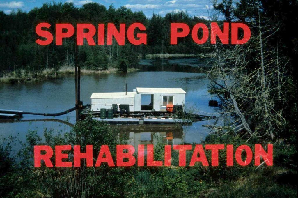
What is a Spring Pond?
|
|
|
- Norman Douglas
- 5 years ago
- Views:
Transcription
1
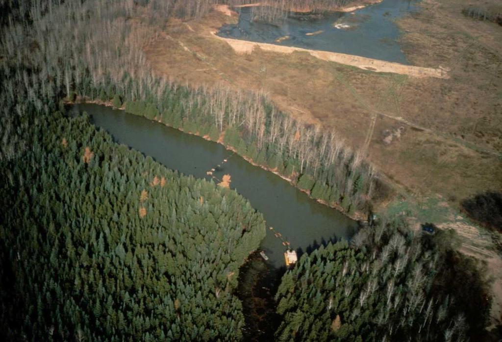
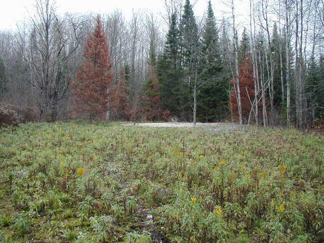
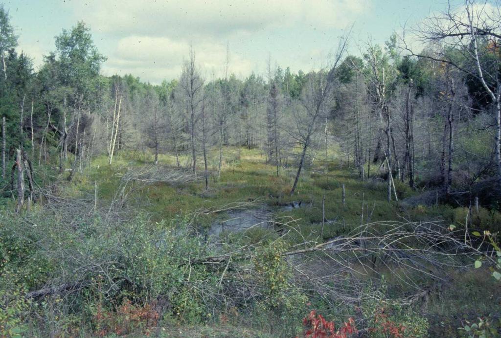
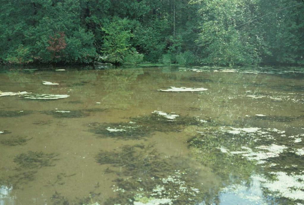
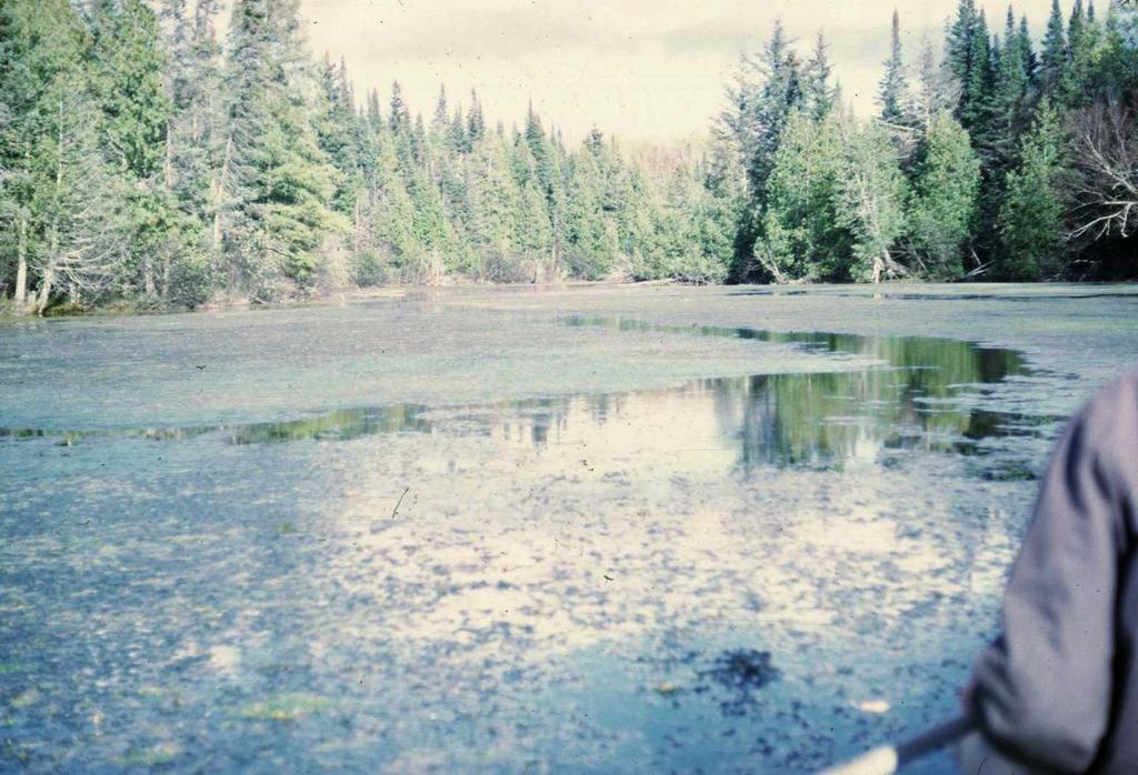
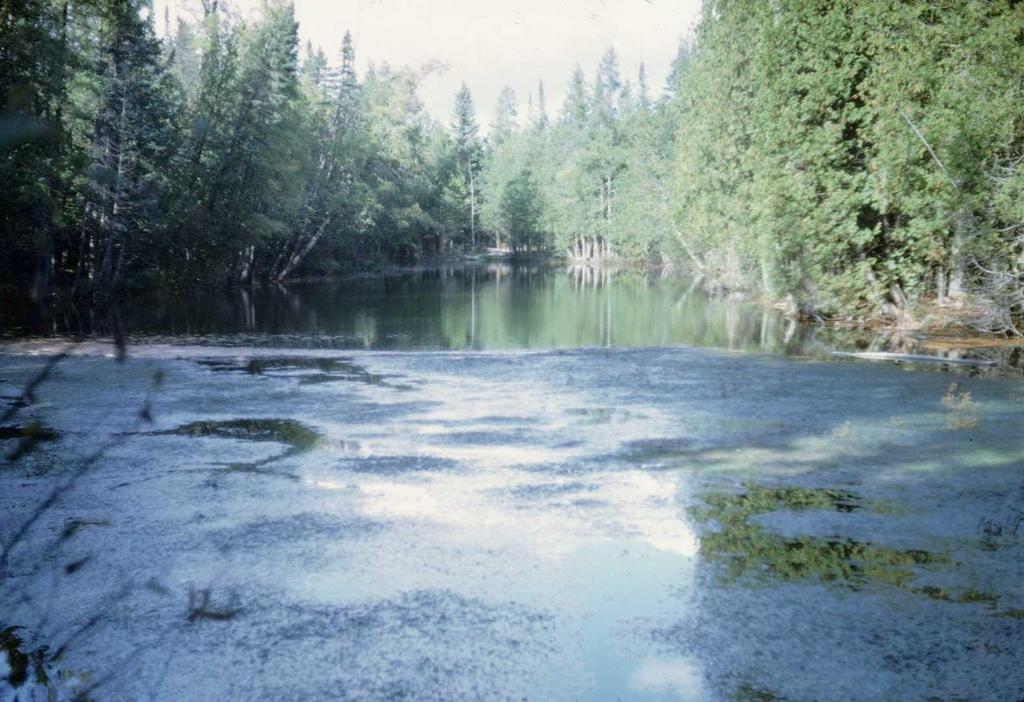
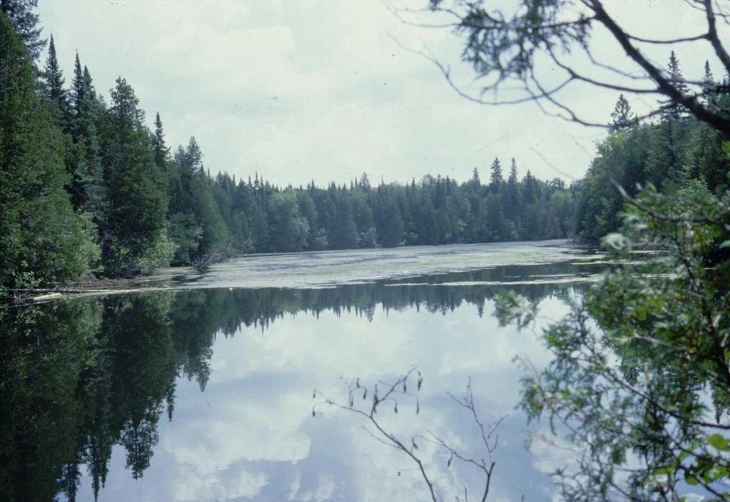
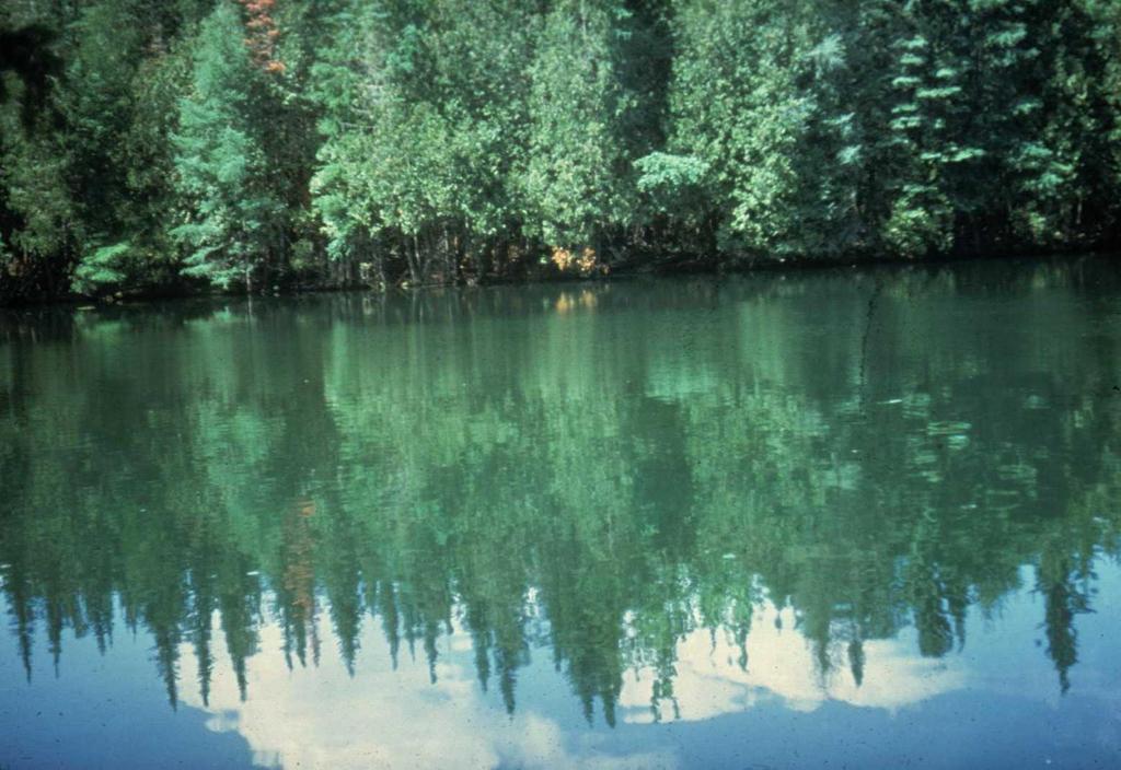
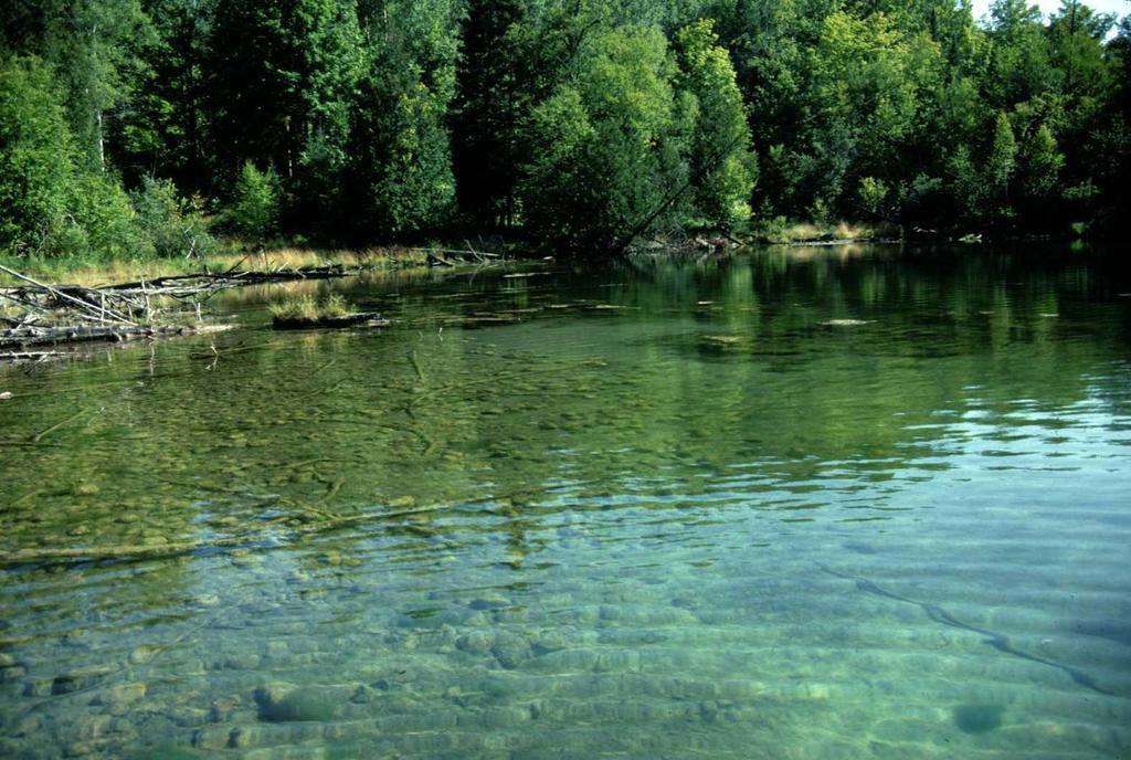
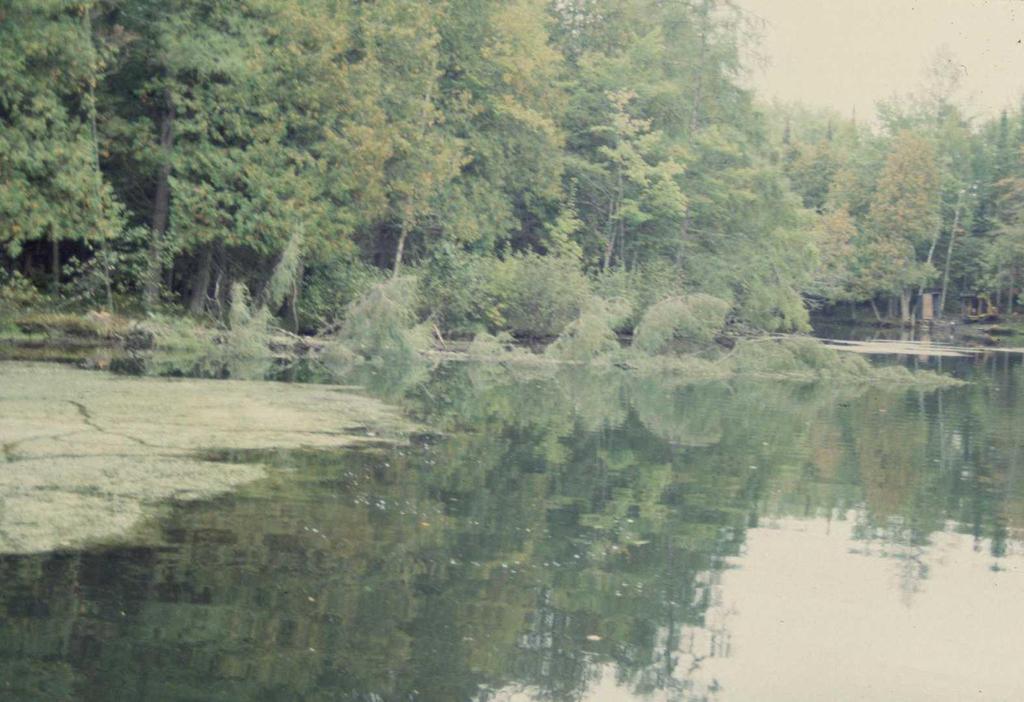
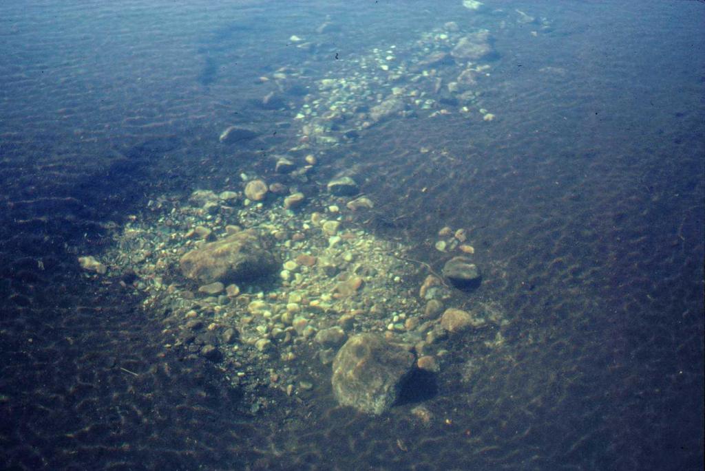
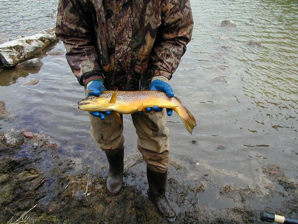
2 What is a Spring Pond? Natural lake Naturally reproducing trout populations Coldwater ecosystem Fed by significant amounts of spring water Always has an outlet creek spring water has to go out somewhere Sometimes has an inlet creek or creeks and if so, they are usually trout water also Associated with trout streams - usually in the headwaters of trout streams Important summer, winter, and spawning habitat for trout
3 What is Not a Spring Pond? Any warmwater ecosystem Any excavated pond managed for trout Any warmwater lake converted to stocked trout management Any system where trout do not naturally reproduce
4 Typical Spring Pond Characteristics Usually small natural lakes less than 5 acres in size Many are less than an acre in size or just a wide spot or flowage portion of a trout stream system McGee Lake is one of the biggest spring ponds at 22.7 acres Significant springs = coldwater ecosystem Naturally reproducing trout populations
5
6

7
8
9
10
11
12
13
14
15
16
17
18
19
20
21
22
23
24
25
26
27
28
29
30
31
32
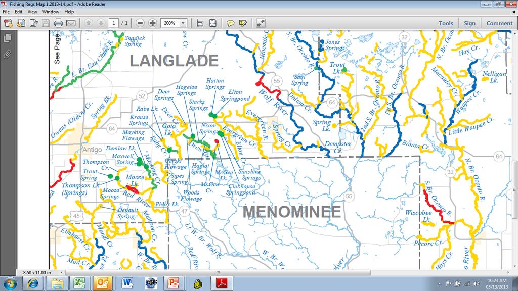
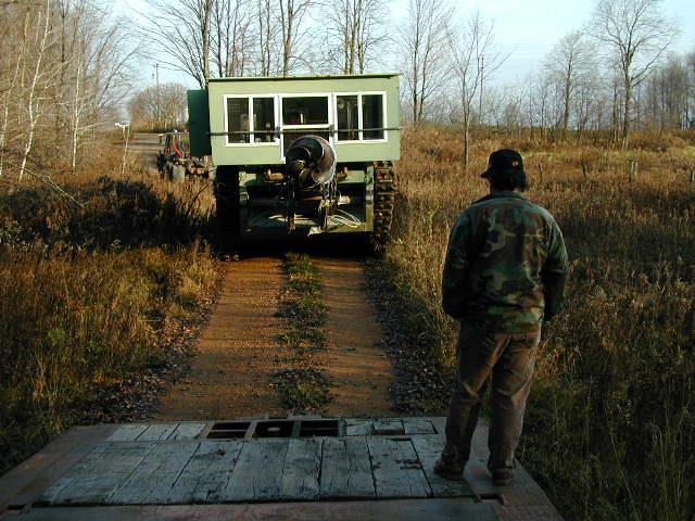
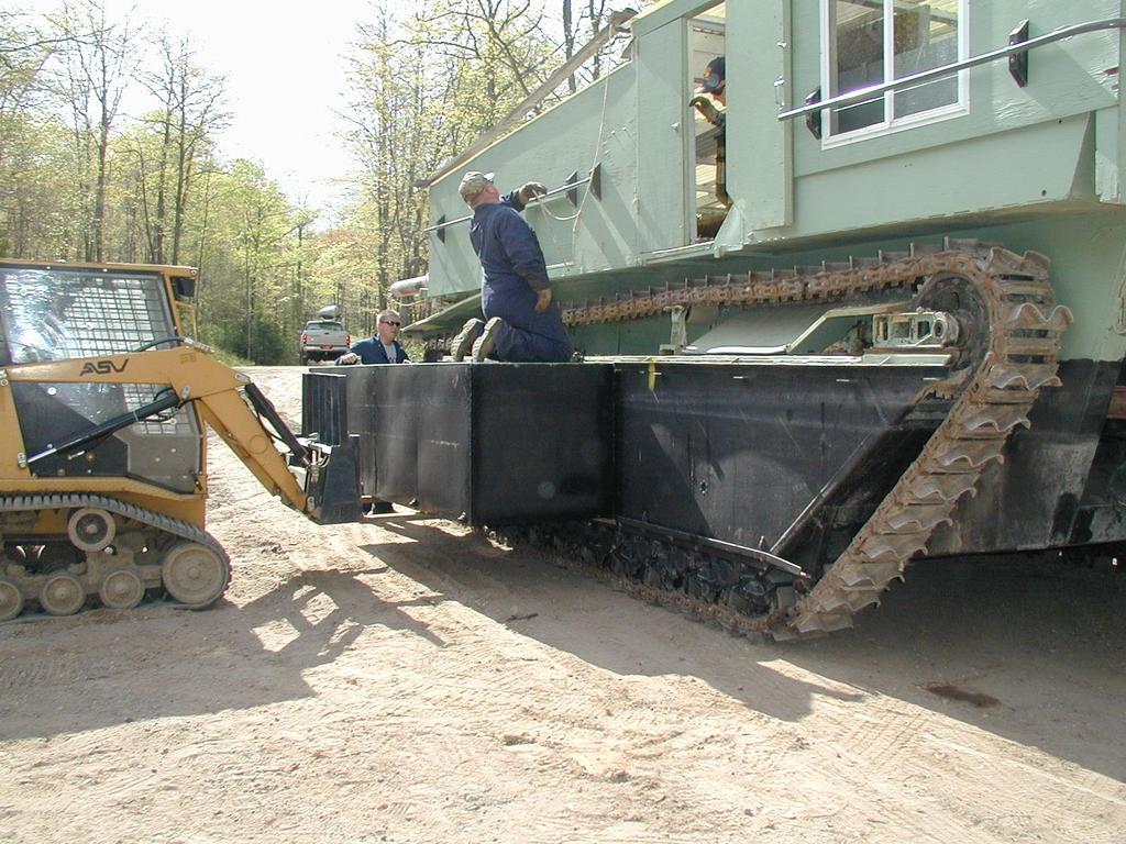
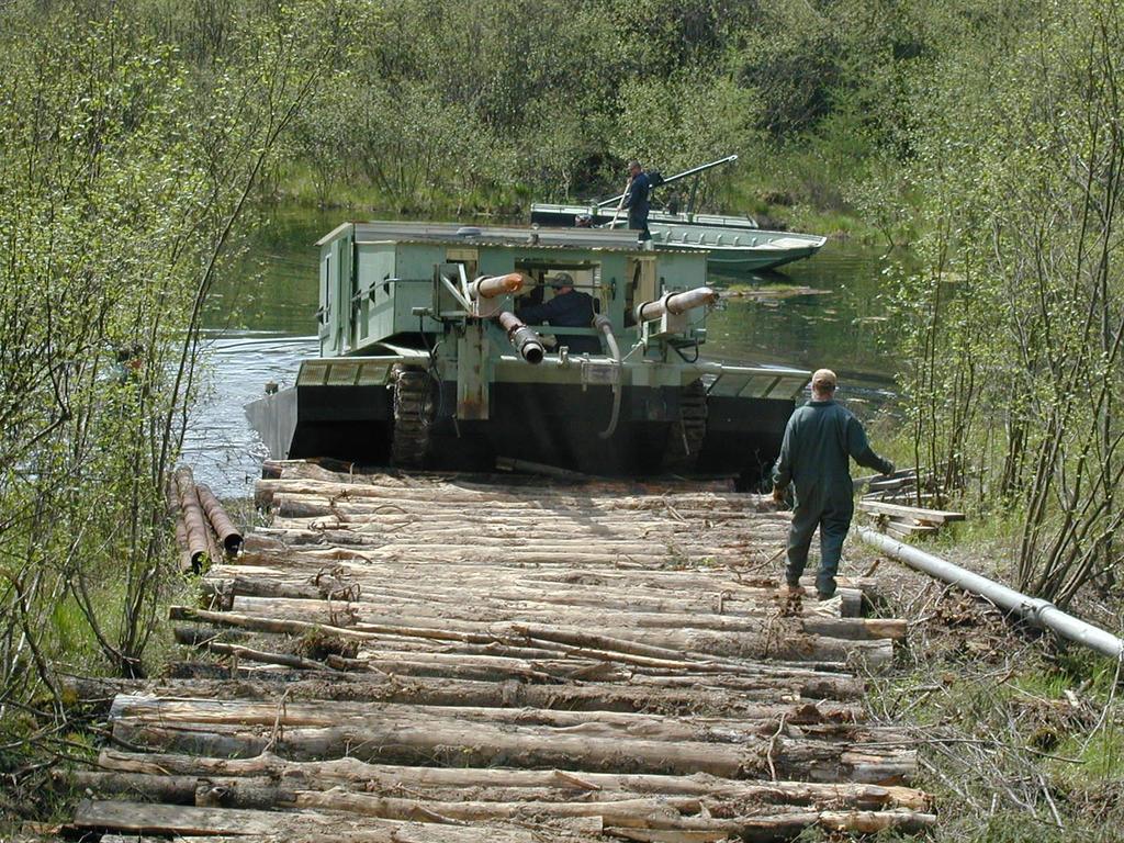
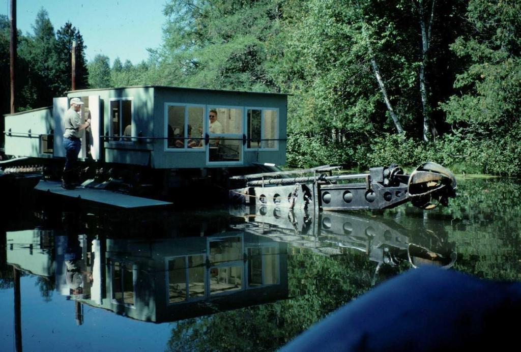
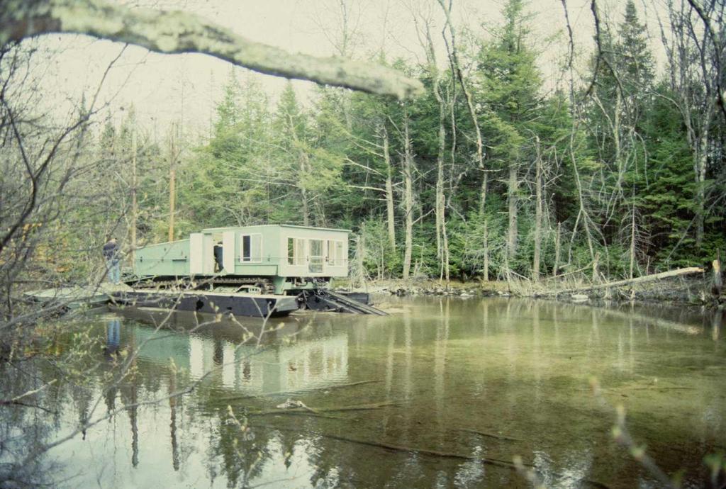
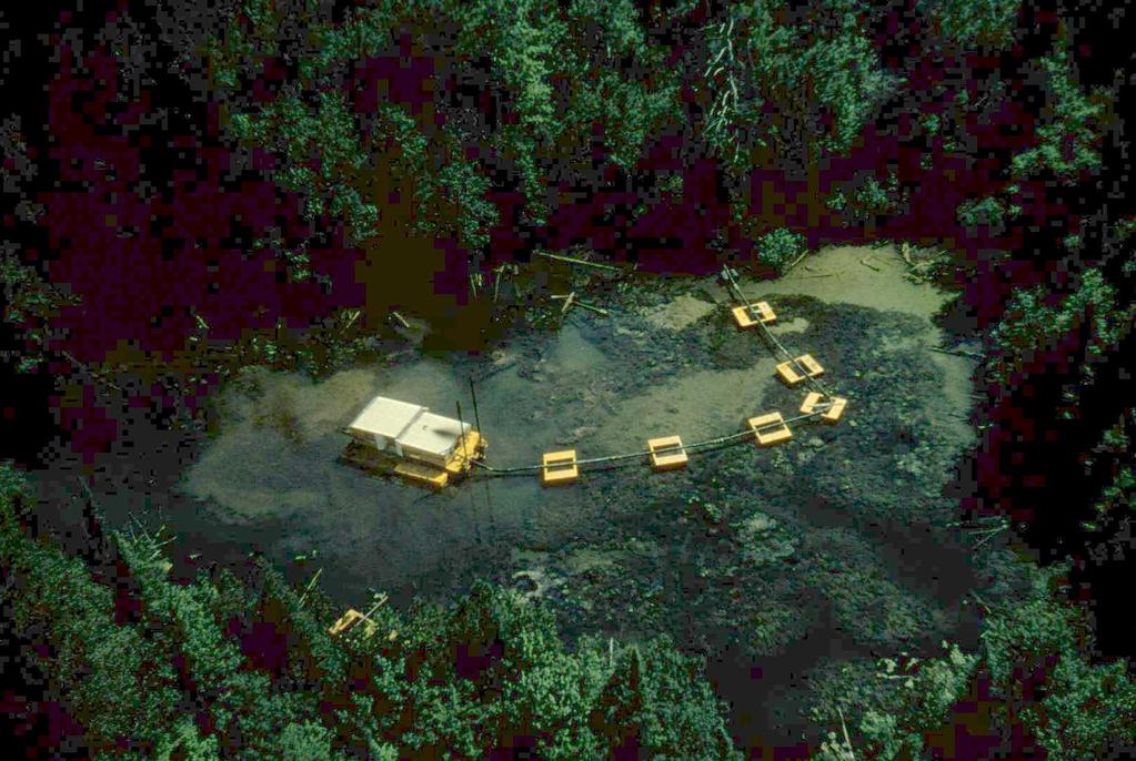
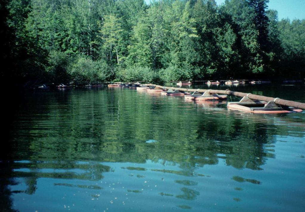
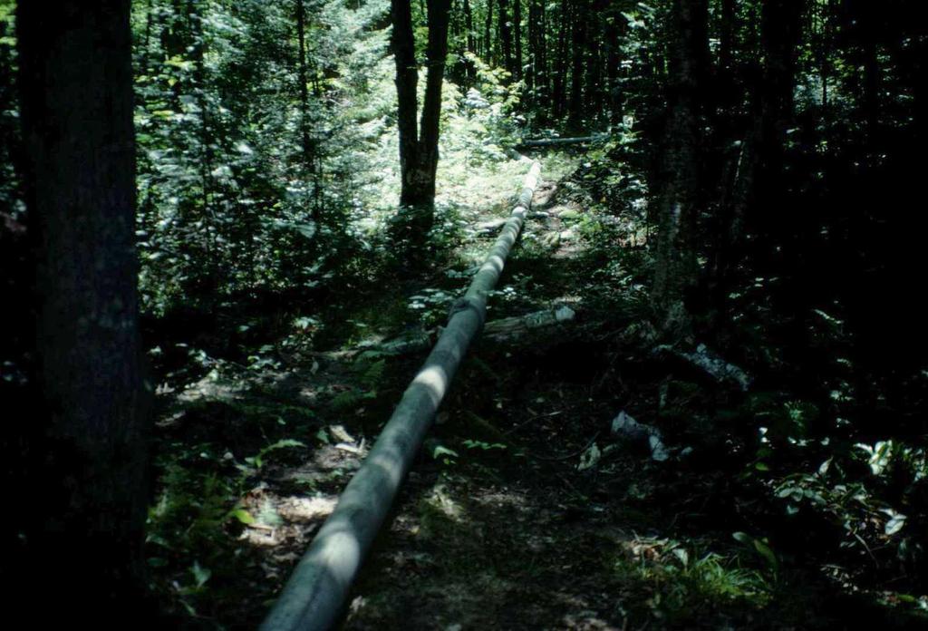
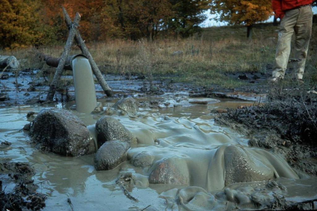
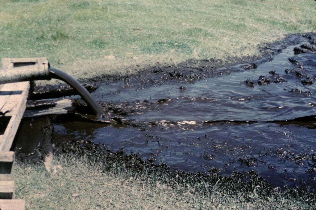
33 DREDGED SPRING PONDS - ANTIGO AREA Year Dredged Name Acres County Location Quarter- Quarter Section Trout Species 1961 Spring Lake 2.4 Lincoln T32N R7E S16 SENE Brook Spiegel Spring 1.2 Marathon T29N R10E S15 NESW Brook & Brown Hoglot Springs 0.9 Langlade T31N R13E S29 SWNW Brook Jones Springs 6.6 Oconto T32N R15E S6-7 SWNW Brook Mercer Spring 0.5 Oneida T39N R5E S11 NWSE Brook Sportsman Lake 2.0 Shawano T28N R11E S12 NWSW Brook Rabe Lake 6.1 Langlade T31N R12E S27 NWNW Brook & Rainbow Hogelee Spring #1 2.6 Langlade T31N R12E S24 SESE Brook Shadick Spring 4.3 Langlade T32N R11E S1 SWNW Brook 1, Wooduck Springs 0.7 Langlade T33N R11E S2 SWSE Brook & Brown King Spring 0.4 Lincoln T33N R7E S13 NWSE Brook Hogelee Spring #2 1.3 Langlade T31N R12E S24 SESE Brook Sunshine Springs 0.4 Langlade T31N R13E S21 NWSE Brook & Brown Clubhouse Springpond 2.1 Langlade T31N R13E S21 NWSE Brook & Brown Lily Springs 1.8 Langlade T33N R13E S13 NWNE Brook Krause Springs 0.9 Langlade T31N R12E S28 NENE Brook Woods Flowage 10.0 Langlade T31N R13E S30 SWNW Brook Totten Spring 1.9 Marathon T29N R10E S15 NESW Brook & Brown Denault Spring 0.5 Langlade T30N R11E S25 SENW Brook Nixon Springs 1.6 Langlade T31N R13E S30 SWNE Brook & Rainbow Sipes Spring 0.7 Langlade T30N R12E S12 NENE Brook Kippenberg Spring 0.1 Lincoln T33N R8E S17 SESE Brook Town Line Springs 2.5 Langlade T31N R13E S13 NENE Brook & Brown Deer Creek (Parsons) Spring 0.8 Langlade T31N R12E S14 SESE Brook Camp One Springs 11.0 Forest T34N R15E S2 SENE Brook Johnson Spring 4.0 Forest T35N R15E S25 NESW Brook Evergreen Spring 0.7 Langlade T31N R14E S30 NENW Brook & Brown Southern Sullivan Spring 3.6 Oconto T33N R16E S36 NWSW Brook West Goodyear Springs 3.9 Vilas T42N R8E S14 NWSE Brook Garski Flowage 15.6 Langlade T31N R12E S35 SWNW Brook Clark Spring 1.3 Marathon T28N R10E S5 NWNE Brook Town (Mountain) Spring 1.8 Oconto T31N R16E S11 SESW Brook 2, Forbes Spring 1.9 Oconto T33N R17E S29 NENE Brook Elvoy Springs 2.1 Forest T41N R13E S20 NESW Brook & Brown 1, Weix Spring 1.6 Langlade T33N R11E S3 NWNW Brook & Brown Drab Spring (Weasel & big dredge) 0.2 Langlade T30N R12E S19 SWSE Brook Koepsell Spring (Weasel) 0.3 Marathon T27N R10E S10 NESW Brook Saul Spring 6.4 Langlade T32N R14E S24 SENE Brook & Brown Brule Spring 11.0 Forest T40N R12E S2 SESW Brook Jacobson Spring 0.8 Marathon T27N R10E S2 NWNE Brook Hatton Springs 0.5 Langlade T31N R13E S8 NWSE Brook & Brown Elton Springpond 6.5 Langlade T31N R13E S9 SWSW Brook & Brown Markgraf Springs 1.8 Langlade T33N R12E S7 NWNW Brook 3, Hoglot Springs 0.9 Langlade T31N R13E S29 SWNW Brook Starks Springs 3.0 Langlade T31N R13E S30 SWNE Brook & Rainbow Willow Springs 4.4 Langlade T33N R11E S11 NWNE Brook & Brown Trout Spring 1.7 Langlade T30N R12E S7 SESE Brook & Brown Maxwell Spring 3.1 Langlade T30N R12E S3 SENW Brook & Brown Woodboro Springs 0.8 Oneida T36N R7E S11 SWSE Brook McGee Lake (2 Spring Areas) 22.7 Langlade T31N R13E S28 SWNW Brook Polar (Page s) Spring 1.7 Langlade T33N R11E S2 NENE Brook & Brown Northern Sullivan Springs (Twins) 3.6 Oconto T33N R16E S36 NWSW Brook Trout Springs 2.1 Vilas T42N R7E S29 SWNW Brook Karbergers Springs 2.1 Langlade T31N R13E S30 SESE Brook Spring 1-9b (Hemlock Springs) 1.6 Oconto T33N R15E S1 NESW Brook Blue Springs 2.0 Langlade T33N R11E S3 NWSE Brook & Brown ? Spring 2-16 (Kedrick Springs) 0.5 Langlade T32N R11E S2 SESE Brook 1 * Access Codes: 1 - Walk-in trail access across public land 2 - Public boat launch with parking area 3 - Walk-in access across public easement 4 Fishing Pier with drive-in access Through 2015: 55 years (1961 Present) 55 ponds acres of trout water improved 8 counties (Forest 4, Langlade 32, Lincoln 3, Marathon 5, Oconto 6, Oneida 2, Shawano 1, Vilas 2) Access*
34 Antigo Area Spring Pond Dredging Program 55 Years ( Present) 55 Spring Ponds Acres of Self Sustaining Trout Water 8 Counties: Langlade - 32 Marathon - 5 Oconto - 6 Forest - 4 Lincoln - 3 Oneida - 2 Vilas - 2 Shawano - 1
35
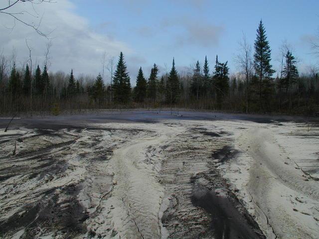
36 High Benefit:Cost Ratio ~ $30,000 per year (one 1-acre or smaller spring pond per year) Improved habitat will last hundreds, very likely thousands of years ($30-$300 annual cost over life of project) Benefits NR trout populations which respond positively More living space for trout especially larger trout Improved habitat supports more pounds of trout per acre Improved spawning habitat can result Highly visible program with much public support (TU and other angler groups)

37
38
39
40
41


42 Acknowledgements: Antigo Fisheries Personnel & Helpers Throughout the Years Trout Unlimited Chapters in Northeast Wisconsin Dave Seibel Wisconsin Department of Natural Resources - Antigo david.seibel@wisconsin.gov Ext. 3112
Appendix D. Special Use Permit Legal Descriptions
 Appendix D Special Use Permit Legal Descriptions TWE Project D-1 Manti-La Sal National Forest 600 kv Transmission Line Long-Term Right-of-Way: T. 13 S., R. 2 E., sec. 8, lot 1; PB 37, unsurveyed protracted.
ALFORDS With Federal Lands in LOUISIANA. Alfords receiving federal lands in Louisiana
 ALFORDS With Federal Lands in LOUISIANA [The original version of this was published in AAFA ACTION #64, Spring 2004, Vol. XVI, No. 4, p. 16-22. While that version is static this online version my be updated
. DELINQUENT 2012 TAXES MINERAL RIGHTS
 DELINQUENT 2012 TAXES MINERAL RIGHTS 1 1S0 290 M $3628* BEAMON, ROBERT C & WILLIAM G N2NE4SE4, SE4NE4, SEC 30 TWP 27 RNG 68 60A 1/2 INT S2SW4, SEC 20 SW4NE4, SEC 30 TWP 27 RNG 67 120A 1/4 INT SE4NE4, NE4SE4,
Real Property. Amanda Bartek-Young Richardson County Treasurer
 NOTICE OF DELINQUENT PROPERTY TAX SALE RICHARDSON COUNTY TREASURER'S OFFICE FALLS CITY, NEBRASKA The following is a list of all lands and lots in Richardson County, Nebraska on which taxes are due and
CO RD T14 R118 SEC 9 PT NW1/4NW1/4 AKA TRACT 80 HIGH POINT RANCH PH II RECORD OF SURVEY 2579 STATE HWY 150 S - KNIGHT HOLLOW SUB BLK 1 LT 2
 CO RD 173 - T14 R118 SEC 9 PT NW1/4NW1/4 AKA TRACT 80 HIGH POINT RANCH PH II RECORD OF SURVEY 2579 STATE HWY 150 S - KNIGHT HOLLOW SUB BLK 1 LT 2 CO RD 164 - T13 R119 SEC 23 N1/2NW1/4NW1/4NW1/4 154 INDIAN
6TH PELLETIER BROOK LAKE T15 R9, Aroostook Co. U.S.G.S. Gardner Pond, Maine (7 1/2 )
") 6TH PELLETIER BROOK LAKE T15 R9, Aroostook Co. U.S.G.S. Gardner Pond, Maine (7 1/2 ) Fishes Brook trout Minnows Blacknose dace Pearl dace Physical Characteristics Area - 27 acres Average depth - 2 feet
6TH PELLETIER BROOK LAKE T15 R9, Aroostook Co. U.S.G.S. Gardner Pond, Maine (7 1/2 ) Fishes Brook trout Minnows Blacknose dace Pearl dace Physical Characteristics Area - 27 acres Average depth - 2 feet
Notice. Proposed Changes to List of Class A Wild Trout Waters September 2017
 Notice Proposed Changes to List of Class A Wild Waters September 2017 The Fish and Boat Commission (Commission) is considering changes to its list of Class A Wild Streams. Under 58 Pa. Code 57.8a (relating
[LLNVC01000.L ET0000; LRORF ; MO# ] Public Land Order No. 7873; Withdrawal of Public Land for Land Management
![[LLNVC01000.L ET0000; LRORF ; MO# ] Public Land Order No. 7873; Withdrawal of Public Land for Land Management](/thumbs/91/105541487.jpg "[LLNVC01000.L ET0000; LRORF ; MO# ] Public Land Order No. 7873; Withdrawal of Public Land for Land Management") This document is scheduled to be published in the Federal Register on 08/31/2018 and available online at https://federalregister.gov/d/2018-18998, and on govinfo.gov 4310 HC DEPARTMENT OF THE INTERIOR
This document is scheduled to be published in the Federal Register on 08/31/2018 and available online at https://federalregister.gov/d/2018-18998, and on govinfo.gov 4310 HC DEPARTMENT OF THE INTERIOR
Michigan Department of Natural Resources Status of the Fishery Resource Report Page 1
 Michigan Department of Natural Resources 2008-59 Status of the Fishery Resource Report Page 1 Bowens Manistee County, (T24N R16W Sec. 11, 12, 13, 14, 15, 24, and 30). Last surveyed 2008 Mark A. Tonello
Crooked Lake Oakland County (T4N, R9E, Sections 3, 4, 9) Surveyed May James T. Francis
 Surveyed May James T. Francis") Michigan Department of Natural Resources Status of the Fishery Resource Report No. 2004-1, 2004 Crooked Lake Oakland County (T4N, R9E, Sections 3, 4, 9) Surveyed May 2002 James T. Francis Environment Crooked
Michigan Department of Natural Resources Status of the Fishery Resource Report No. 2004-1, 2004 Crooked Lake Oakland County (T4N, R9E, Sections 3, 4, 9) Surveyed May 2002 James T. Francis Environment Crooked
NEVADA DEPARTMENT OF WILDLIFE STATEWIDE FISHERIES MANAGEMENT
 NEVADA DEPARTMENT OF WILDLIFE STATEWIDE FISHERIES MANAGEMENT FEDERAL AID JOB PROGRESS REPORTS F-20-50 2014 BILK CREEK RESERVOIR WESTERN REGION 1 NEVADA DEPARTMENT OF WILDLIFE, FISHERIES DIVISION JOB PROGRESS
Trout Unlimited and the Kittatinny Ridge Coalition.
 Trout Unlimited and the Kittatinny Ridge Coalition www.tu.org Trout Unlimited TU works to protect, reconnect, restore and sustain North America s coldwater fisheries and their watersheds. We use science
BIG TWIN LAKE Kalkaska County (T28N, R05W, Section 18, and T28N, R06W, Section 13) Surveyed May 1999
 Surveyed May 1999") Michigan Department of Natural Resources Status of the Fishery Resource Report No. 2001-1, Year 2001 BIG TWIN LAKE Kalkaska County (T28N, R05W, Section 18, and T28N, R06W, Section 13) Surveyed May 1999
Michigan Department of Natural Resources Status of the Fishery Resource Report No. 2001-1, Year 2001 BIG TWIN LAKE Kalkaska County (T28N, R05W, Section 18, and T28N, R06W, Section 13) Surveyed May 1999
Michigan Dept. of Natural Resources Status of the Fishery Resource Report Page 1. Weber Lake Cheboygan County, T34N, R3W, Sec.
 Michigan Dept. of Natural Resources 2012-143 Status of the Fishery Resource Report Page 1 Weber Lake Cheboygan County, T34N, R3W, Sec. 31 Neal Godby, Fisheries Biologist Environment Weber Lake is a 28.5-acre
Choctaw Tribe Subsurface Minerals Database March 1, 2019
 Atoka 01N 13E 33 1/2 INT; S2SE 40 CHOCTAW/CHICKASAW N unlease NO Atoka 01N 15E 29 1/2 INT; SWSWNW 1 CHOCTAW/CHICKASAW N unlease NO Atoka 01S 12E 21 1/2 INT; N2SWNESW 2.5 CHOCTAW/CHICKASAW N unlease NO
IDAHO High Mountain Lake Stocking
 IDAHO High Mountain Lake Stocking The Development and Current Practices of Idaho's High Mountain Lake Stocking Program Brief timeline on when fish stocking began in Idaho. Goals of Fish Management for
Wisconsin s Citizen-Based Monitoring Partnership Program and Trout Unlimited Driftless Area Restoration Effort (TUDARE)
") Wisconsin s 2010-11 Citizen-Based Monitoring Partnership Program and Trout Unlimited Driftless Area Restoration Effort (TUDARE) TUDARE Stream Monitoring Sites Established in 2010-2011 Summary Prepared
Wisconsin s 2010-11 Citizen-Based Monitoring Partnership Program and Trout Unlimited Driftless Area Restoration Effort (TUDARE) TUDARE Stream Monitoring Sites Established in 2010-2011 Summary Prepared
NEVADA DEPARTMENT OF WILDLIFE STATEWIDE FISHERIES MANAGEMENT
 NEVADA DEPARTMENT OF WILDLIFE STATEWIDE FISHERIES MANAGEMENT FEDERAL AID JOB PROGRESS REPORTS F-20-49 2013 SQUAW CREEK RESERVOIR WESTERN REGION Contents NEVADA DEPARTMENT OF WILDLIFE, FISHERIES DIVISION
NEVADA DEPARTMENT OF WILDLIFE STATEWIDE SPORT FISHERIES MANAGEMENT
 NEVADA DEPARTMENT OF WILDLIFE STATEWIDE SPORT FISHERIES MANAGEMENT FEDERAL AID JOB PROGRESS REPORT F-20-50 2014 Urban Sport Fisheries SOUTHERN REGION NEVADA DEPARTMENT OF WILDLIFE, FISHERIES DIVISION ANNUAL
Crawford Reservoir. FISH SURVEY AND MANAGEMENT INFORMATION Eric Gardunio, Fish Biologist Montrose Service Center
 FISH SURVEY AND MANAGEMENT INFORMATION General Information: Crawford Reservoir is a popular fishery that provides angling opportunity for yellow perch, channel catfish, northern pike, rainbow trout, black
NEVADA DEPARTMENT OF WILDLIFE STATEWIDE FISHERIES MANAGEMENT
 NEVADA DEPARTMENT OF WILDLIFE STATEWIDE FISHERIES MANAGEMENT FEDERAL AID JOB PROGRESS REPORTS F-20-49 2013 LAKE TAHOE WESTERN REGION NEVADA DEPARTMENT OF WILDLIFE, FISHERIES DIVISION ANNUAL PROGRESS REPORT
WISCONSIN DEPARTMENT OF NATURAL RESOURCES
 WISCONSIN DEPARTMENT OF NATURAL RESOURCES RESEARCH REPORT187 April 2004 A Compendium of 58 Trout Stream Habitat Development Evaluations in Wisconsin 1985-2000 1 by Ed L. Avery Bureau of Integrated Science
Maple Lake Population Survey
 Maple Lake Survey Located in Willow Springs approximately 1 mile west of Willow Springs Rd. (104 th Ave.) at Wolf Rd. and 95 th St. Constructed in the 1920 s this 60 acre lake drops down to 20.4 feet in
The Cove Run Brook Trout Restoration Project with the Northern Garrett High School AP Environmental Science Class,
 The Cove Run Brook Trout Restoration Project with the Northern Garrett High School AP Environmental Science Class, 2012 2014. Image or Graphic Presented By: Alan W. Klotz, Western Region District I, Inland
Bode Lake - South Population Survey
 Bode Lake - South Survey Located in Hoffman Estates on the north side of Bode Rd. 1 mile west of Barrington Rd. Bode Lake is made up of two lakes along Poplar Creek; the larger and deeper Bode Lake South
NEVADA DEPARTMENT OF WILDLIFE STATEWIDE FISHERIES MANAGEMENT
 NEVADA DEPARTMENT OF WILDLIFE STATEWIDE FISHERIES MANAGEMENT FEDERAL AID JOB PROGRESS REPORTS F-20-52 2016 LAKE TAHOE WESTERN REGION NEVADA DEPARTMENT OF WILDLIFE, FISHERIES DIVISION ANNUAL PROGRESS REPORT
ESTABLISHING A TROUT FISHERY IN MILL CREEK
 ESTABLISHING A TROUT FISHERY IN MILL CREEK PROJECT OVERVIEW ANNARBOR CHAPTER OF TROUT UNLIMITED MILL CREEK FISHERY DEVELOPMENT COMMITTEE Discussion Agenda Project background and goals Project description
NEVADA DEPARTMENT OF WILDLIFE STATEWIDE SPORT FISHERIES MANAGEMENT
 NEVADA DEPARTMENT OF WILDLIFE STATEWIDE SPORT FISHERIES MANAGEMENT FEDERAL AID JOB PROGRESS REPORT F-20-49 2013 Urban Sport Fisheries SOUTHERN REGION NEVADA DEPARTMENT OF WILDLIFE, FISHERIES DIVISION ANNUAL
R & E Grant Application 13 Biennium
 R & E Grant Application 13 Biennium Project #: 13-068 Project Information R&E Project $68,220.00 Request: Match Funding: $185,400.00 Total Project: $253,620.00 Start Date: 8/2/2014 End Date: 6/30/2015
NEVADA DEPARTMENT OF WILDLIFE STATEWIDE FISHERIES MANAGEMENT
 NEVADA DEPARTMENT OF WILDLIFE STATEWIDE FISHERIES MANAGEMENT FEDERAL AID JOB PROGRESS REPORTS F-20-48 2012 LAKE TAHOE WESTERN REGION Contents NEVADA DEPARTMENT OF WILDLIFE, FISHERIES DIVISION ANNUAL PROGRESS
Environmental Review and Permitting for Wild Trout
 Environmental Review and Permitting for Wild Trout Tom Shervinskie Wild Trout Summit Watershed Analysis Section August 26, 2017 Division of Environmental Services The mission of the Pennsylvania Fish and
Quarry Lakes Fisheries Report EBRPD Fisheries Department. Joe Sullivan Fisheries Resource Analyst Peter Alexander Fisheries Program Manager
 Quarry Lakes Fisheries Report 2011 EBRPD Fisheries Department Joe Sullivan Fisheries Resource Analyst Peter Alexander Fisheries Program Manager Introduction The purpose of this report is to give lake supervisors
What was the historic coaster fishery like?
 1 of 6 1/30/2012 12:25 PM Home About Topics Contact Us Fishing Calendar Fish ID Tips FAQs Hack Noyes Research Vessel Is it a unique strain long lost from Wisconsin's shoreline? Fisheries Reports Tributaries
Green Lake Population Survey
 Located next to the Green Lake Aquatic Center in Calumet City on the north side of 159 th St, east of Torrence Ave. Size can be deceiving; this 5 acre lake is the deepest lake in the District with a maximum
Designated Trout Stream Additions Arrowhead Creek
 Designated Trout Stream Additions Arrowhead Creek A small reach of Arrowhead Creek was inadvertently left off the list of sections when the stream was originally designated. This designation would fill
NEVADA DEPARTMENT OF WILDLIFE STATEWIDE SPORT FISHERIES MANAGEMENT
 NEVADA DEPARTMENT OF WILDLIFE STATEWIDE SPORT FISHERIES MANAGEMENT FEDERAL AID JOB PROGRESS REPORT F-20-53 2017 RUBY MOUNTAIN & EAST HUMBOLDT HIGH MOUNTAIN LAKES NEVADA DEPARTMENT OF WILDLIFE, FISHERIES
Previous Stocking Black crappie. Channel catfish. Cutbow. Rainbow trout. Saugeye Black crappie. Channel catfish. Cutbow.
 Runyon Lake FISH SURVEY AND MANAGEMENT DATA Carrie Tucker - Aquatic Biologist (Pueblo) carrie.tucker@state.co.us / 719-561-5312 General Information: Runyon Lake, which is approximately thirty-five acres
Rolling Knolls Pond Population Survey
 Located near the town of Elgin on the west side of Rohrssen Rd. between Illinois Route 58 and U.S.- 20. This small 1.8 acre pond has a maximum depth of 7.5 feet and is occasionally influenced by Poplar
Foy Ranch. Farm & Ranch Real estate Department. Guernsey / Platte County / WY !!!!!!!!!!
 Foy Ranch Guernsey / Platte County / WY Farm & Ranch Real estate Department Coldwell Banker The Property exchange & Burnett Farm and Ranch Location Being just 5 miles west of i-25, and only 10 miles north
Beaver Trapping Questionnaire By Brian Dhuey and John Olson
 Beaver Trapping Questionnaire 2009-2010 By Brian Dhuey and John Olson Abstract An estimated 2,344 people trapped for beaver during the 2009-10 beaver trapping season. They harvested an estimated 31,049
Beaver Trapping Questionnaire By Brian Dhuey and John Olson
 Beaver Trapping Questionnaire 2012-2013 By Brian Dhuey and John Olson Abstract Beaver trappers, days afield, sets made and mean beaver trapped during the 2012-13 season were all down from 2011-12 levels.
2. BACKGROUND. The West Branch Susquehanna River watershed
 2. BACKGROUND 2.1 The Susquehanna River watershed While the WBSR watershed includes several developed areas, forests cover about 83% of the land, and agricultural land makes up about 10%. Most abandoned
Beaver Valley Ranch Steamboat Springs, Colorado
 Beaver Valley Ranch Steamboat Springs, Colorado Introduction Hidden in the heart of one of Colorado s last unspoiled mountain valleys, Beaver Valley Ranch is tailor-made for hunting and fishing of exceptional
Fisheries Resources in White Pine County
 Fisheries Resources in White Pine County June 22, 2013 Update to the Nevada Board of Wildlife Commissioners Jon C. Sjöberg Chief of Fisheries Comins Lake Located 7 miles south of Ely. Built in 1953 as
Wampum Lake Population Survey
 Wampum Lake Survey Located in Thornton on Thornton-Lansing Rd. 1½ mile west of Torrence Ave. Wampum Lake is 35 acres is size and has a maximum depth of 14.1 feet. Northern pike, largemouth bass, bluegill,
Current Wild Trout Classification Overview and Listing Process
 Current Wild Trout Classification Overview and Listing Process Pennsylvania Wild Trout Summit David Nihart - PFBC August 26, 2017 Wild Trout Programs Wild Trout Waters (Natural Reproduction) Class A Wild
Arrowhead Lake Population Survey
 Located in Palos Heights at 135 th St, east of Harlem Ave. Arrowhead Lake is a 13 acre body of water with a maximum depth of 12.6 feet. Fish species found in this lake include largemouth bass, bluegill,
Minnesota Department of Natural Resources Division of Fish and Wildlife Section of Fisheries. Stream Survey Report. Luxemburg Creek.
 Minnesota F-29-R(P)-24 Area 315 Study 3 March 2016 Minnesota Department of Natural Resources Division of Fish and Wildlife Section of Fisheries Stream Survey Report Luxemburg Creek 2015 Mark Pelham Sauk
NEVADA DEPARTMENT OF WILDLIFE STATEWIDE FISHERIES MANAGEMENT
 NEVADA DEPARTMENT OF WILDLIFE STATEWIDE FISHERIES MANAGEMENT FEDERAL AID JOB PROGRESS REPORTS F-20-52 2016 REDBAND TROUT EASTERN REGION NEVADA DEPARTMENT OF WILDLIFE, FISHERIES DIVISION ANNUAL JOB PROGRESS
Robert Weber PA Fish and Boat Commission Fisheries Biologist Fish Management Division
 Robert Weber PA Fish and Boat Commission Fisheries Biologist Fish Management Division Pennsylvania s Flowing Water Resources - Surveyed Stream Sections - Unassessed Stream Sections Pennsylvania s Flowing
Schiller Pond Population Survey
 Located in the town of Schiller Park on Irving Park Rd. just west of Cumberland Ave. This small 6 acre pond has a maximum depth of 6.3 feet. In addition to largemouth bass and bluegill, Schiller Pond is
FINAL Caples Lake Fisheries Management Plan. Version 4.0
 FINAL Caples Lake Fisheries Management Plan Version 4.0 August 15, 2008 Purpose The Caples Lake Fisheries Management Plan (Plan) outlines the stocking plan to reestablish a sport fishery in Caples Lake
LAKES - NACHES RANGER DISTRICT
 United States Department of Agriculture Forest Service Pacific Northwest Region Lakes and Streams Naches Ranger District Consult your current Washington State Department of Fish and Wildlife pamphlet for
Outstanding Iowa Waters, Trout Streams & Value to Northeast Iowa
 Outstanding Iowa Waters, Trout Streams & Value to Northeast Iowa Mike Steuck NE District Fisheries Supervisor Karst, WQ & Livestock: Finding a Balance for a Sensitive Geography May 30, 2017 Healthy Rivers,
Creek, Borders Public Land, Deer & Elk Hunting in the Garnet Mountain Range 160 acres for $195,000
 Granite County Creek, Borders Public Land, Deer & Elk Hunting in the Garnet Mountain Range 160 acres for $195,000 runs through this great Montana property and borders a large block of State Lands for even
Sebec Lake Fisheries Management Plan 2012
 Sebec Lake Fisheries Management Plan 2012 Sebec Lake is a 6,800-acre oligotrophic lake located in northwestern Maine. It has popular fisheries for landlocked salmon, lake trout, and smallmouth bass. Other
Iron Mining In the Penokee Range- What s at Risk Penokee Range
 Iron Mining In the Penokee Range- What s at Risk Penokee Range Dale A. Thomas/NP Studios Introduction The Penokee Gogebic Range extends 25 miles in far northern Wisconsin, through Iron and Ashland counties.
Alberta Conservation Association 2018/19 Project Summary Report. Project Name: North Saskatchewan River Drainage Fish Sustainability Index Data Gaps
 Alberta Conservation Association 2018/19 Project Summary Report Project Name: North Saskatchewan River Drainage Fish Sustainability Index Data Gaps Fisheries Program Manager: Peter Aku Project Leader:
Sag Quarry - West Population Survey
 Located in Lemont on RT 83 and Archer Ave. just north of 111 th St. Like Sag Quarry East, this lake is an old limestone quarry, 14 acres in size and with a maximum depth of 10.3 feet. The species found
Example Applications
 Example Applications The following example applications are intended to present how the tools developed for Trout Unlimited s Brook Trout Conservation Portfolio and Range-wide Assessment of Habitat Condition
NEVADA DEPARTMENT OF WILDLIFE STATEWIDE SPORT FISHERIES MANAGEMENT
 NEVADA DEPARTMENT OF WILDLIFE STATEWIDE SPORT FISHERIES MANAGEMENT FEDERAL AID JOB PROGRESS REPORT F-20-52 2016 Urban Sport Fisheries SOUTHERN REGION NEVADA DEPARTMENT OF WILDLIFE, FISHERIES DIVISION ANNUAL
Maine s Remote Pond Survey Project: A cooperative effort among MDIFW, Maine Audubon and Trout Unlimited
 Maine s Remote Pond Survey Project: A cooperative effort among MDIFW, Maine Audubon and Trout Unlimited Merry Gallagher, Research Fishery Biologist, MDIFW Jeff Reardon, Maine Brook Trout Project Director,
Chickasaw Nation Subsurface Database March 2019
 Atoka 01N 13E 33 1/2 INT; S2SE 40 CHOCTAW/CHICKASAW N unlease NO Atoka 01N 15E 29 1/2 INT; SWSWNW 1 CHOCTAW/CHICKASAW N unlease NO Atoka 01S 12E 21 1/2 INT; N2SWNESW 2.5 CHOCTAW/CHICKASAW N unlease NO
JC Mesa Ranch. Colorado - San Miguel County - Telluride
 Commanding stunning views of Telluride and surrounding peaks, the 2,379 deeded-acre JC Mesa Ranch is one of the only remaining undeveloped and unencumbered ranches in the Telluride area. Surrounded by
Red Cliff Hatchery bolsters Lake Superior coaster population - Stocks walleye in local lakes
 Red Cliff Hatchery bolsters Lake Superior coaster population - Stocks walleye in local lakes By Sue Erickson, Staff Writer Red Cliff,Wis_Rehabilitation of the coaster brook trout population in Lake Superior
Labor Hours per Lane Mile per Severity Index (to date, as of 4/14/16) From Winter Storm Reports,
 From Winter Storm Reports,") Region NC ADAMS $239,584 $341,851 $229,513 $355,706 $445,843 $251,132 $427,062 78.89 107.49 94.17 129.06106.65 84.17 123.39 4.63 6.83 4.79 8.02 7.64 4.49 9.23 0.06 0.06 0.05 0.06 0.07 0.05 0.07 FLORENCE
Region NC ADAMS $239,584 $341,851 $229,513 $355,706 $445,843 $251,132 $427,062 78.89 107.49 94.17 129.06106.65 84.17 123.39 4.63 6.83 4.79 8.02 7.64 4.49 9.23 0.06 0.06 0.05 0.06 0.07 0.05 0.07 FLORENCE
Mogollon Rim and White Mountains Angler Report
 Mogollon Rim and White Mountains Angler Report Becker Lake, Monday, Nov. 6 Blain O.: Becker Lake fished well last week though the water was cold (50- degrees F at the surface). Fish were scattered everywhere
Driftless Trout Resource Management. Vaughn Snook Assistant Fisheries Supervisor DNR Lanesboro Fisheries Office
 Driftless Trout Resource Management Vaughn Snook Assistant Fisheries Supervisor DNR Lanesboro Fisheries Office Topics Stocking Stream Easement Acquisition & Violation Review Habitat Improvement Projects
FOR SALE Sprague River Ranch
 FOR SALE Sprague River Ranch Klamath County, OR 30,620 ± Total acres 15,620 Deeded acres 15,000 Leased acres $23,350,000 The Sprague River Ranch is the quintessential combination of a recreational and
West Branch Susquehanna River Annual Watershed Summit 2018
 West Branch Susquehanna River Annual Watershed Summit 2018 Kathleen Lavelle Field Coordinator Pennsylvania Coldwater Habitat Restoration Program www.tu.org Trout Unlimited Mission: To conserve, protect,
Cold Small River. A Brief Ecological Description of this Michigan River Type
 Cold Small River A Brief Ecological Description of this Michigan River Type Cold Small River segments are defined (by the Michigan Department of Natural Resources, Fisheries Division) as typically having
CASE NO. 2016CW13 (REF NO. 01CW230).
.") IN THE DISTRICT COURT IN AND FOR WATER DIVISION NO. 4 STATE OF COLORADO TO: ALL PERSONS INTERESTED IN WATER APPLICATIONS IN SAID WATER DIVISION NO. 4 Pursuant to C.R.S. 37-92-302, as amended, you are notified
IN THE DISTRICT COURT IN AND FOR WATER DIVISION NO. 4 STATE OF COLORADO TO: ALL PERSONS INTERESTED IN WATER APPLICATIONS IN SAID WATER DIVISION NO. 4 Pursuant to C.R.S. 37-92-302, as amended, you are notified
FISHERIES MANAGEMENT. Georgia Freshwater Fisheries. Department of Natural Resources Wildlife Resources Division
 FISHERIES MANAGEMENT Georgia Freshwater Fisheries Fishing in Georgia 1.4 million resident anglers fish in Georgia. Fishing in Georgia generates $1.3 billion in retail sales and a $2.1 billion ripple effect
BASS LAKE PLANNING UNIT Willow Creek Watershed
 Existing Conditions & Uses Overview Reservoir that is a popular summer recreation destination, with substantial residential and recreation development 1,085 acres in Madera County; 149 acres outside and
WFC 10 Wildlife Ecology & Conservation Nov. 29, Restoration Ecology: Rivers & Streams. Lisa Thompson. UC Cooperative Extension
 Restoration Ecology: Rivers and Streams WFC 10 29 Nov 2010 Restoration of ecosystems often involves creating new systems with only partial resemblance to the original ecosystems Lisa Thompson Fisheries
Tampier Lake Population Survey
 Located in Palos Park on 131 st St. between Wolf and Will-Cook Rd. s. Tampier Lake has 131 acres of fishable water, with a maximum depth of 9.4 feet. Walleye, northern pike, largemouth bass and channel
NEVADA DIVISION OF WILDLIFE STATEWIDE FISHERIES MANAGEMENT FEDERAL AID JOB PROGRESS REPORTS F YELLOWSTONE CUTTHROAT TROUT EASTERN REGION
 NEVADA DIVISION OF WILDLIFE STATEWIDE FISHERIES MANAGEMENT FEDERAL AID JOB PROGRESS REPORTS F-20-48 2012 YELLOWSTONE CUTTHROAT TROUT EASTERN REGION NEVADA DEPARTMENT OF WILDLIFE, FISHERIES DIVISION ANNUAL
Notice. Proposed Changes to List of Class A Wild Trout Waters April 2017
 Notice Proposed Changes to List of Class A Wild Waters April 07 The Fish and Boat Commission (Commission) is considering changes to its list of Class A Wild Streams. Under 58 Pa. Code 57.8a (relating to
Michigan Department of Natural Resources Status of the Fishery Resource Report Page 1
 Michigan Department of Natural Resources 2007-33 Status of the Fishery Resource Report Page 1 Grand Sable Lake Alger County, T49N, R14W, Sec. Many Lake Superior watershed, last year surveyed 2004 James
Maryland Chapter Trout Unlimited Brook Trout Conservation Effort
 Maryland Chapter Trout Unlimited Brook Trout Conservation Effort Photo by Matt Kline Portfolio of Recent Work MDTU Brook Trout Conservation Coordinator: Scott C. Scarfone, ASLA sscarfone@oasisdesigngroup.com
Fraser River. FISH SURVEY AND MANAGEMENT INFORMATION Jon Ewert - Aquatic Biologist (Hot Sulphur Springs)
") Fraser River FISH SURVEY AND MANAGEMENT INFORMATION Jon Ewert - Aquatic Biologist (Hot Sulphur Springs) General Information: The Fraser River is a highly diverse river offering many transitions in habitat
Fraser River FISH SURVEY AND MANAGEMENT INFORMATION Jon Ewert - Aquatic Biologist (Hot Sulphur Springs) General Information: The Fraser River is a highly diverse river offering many transitions in habitat
Trout Unlimited. Next Meeting. President s Corner. Little River Chapter. Monday. January 22nd
 HTTP://LRCTU.ORG MONDAY, JANUARY 22, 2018 Trout Unlimited Little River Chapter Next Meeting Monday January 22nd President s Corner With the New Year comes some changes. We will be meeting at a new location,
OREGON WATER RESOURCES DEPARTMENT
 OREGON WATER RESOURCES DEPARTMENT 725 Summer Street NE Suite A PUBLIC NOTICE OF WATER USE REQUESTS Salem OR 97301 March 19, 2019 This notice is also available on our web page at the following address:
2016 Brook Trout Survey Project Remote Ponds and Coastal Streams Volunteer Angler Survey Results Report to Public
 2016 Brook Trout Survey Project Remote Ponds and Coastal Streams Volunteer Angler Survey Results Report to Public Project Introduction: The Brook Trout Survey Project is an ongoing collaboration between
HUBBARD LAKE Alcona County (T27N, R7E; T28N, R7E) Surveyed May and September Tim A. Cwalinski
 Surveyed May and September Tim A. Cwalinski") Michigan Department of Natural Resources Status of the Fishery Resource Report No. 2003-1, 2003 HUBBARD LAKE Alcona County (T27N, R7E; T28N, R7E) Surveyed May and September 1996 Tim A. Cwalinski Environment
Michigan Department of Natural Resources Status of the Fishery Resource Report No. 2003-1, 2003 HUBBARD LAKE Alcona County (T27N, R7E; T28N, R7E) Surveyed May and September 1996 Tim A. Cwalinski Environment
Rebirth of the Pigeon River: Song of the Morning Dam Removal Project
 Major funding for this project was provided by: Michigan Department of Natural Resources Aquatic Habitat Grant Program $293,000 Golden Lotus, Inc. $100,000 Great Lakes Fishery Trust $46,000 Pigeon River
NEVADA DEPARTMENT OF WILDLIFE STATEWIDE FISHERIES MANAGEMENT
 NEVADA DEPARTMENT OF WILDLIFE STATEWIDE FISHERIES MANAGEMENT FEDERAL AID JOB PROGRESS REPORTS F-20-52 2016 Lake Tahoe Rainbow Trout Study WESTERN REGION NEVADA DEPARTMENT OF WILDLIFE, FISHERIES DIVISION
Practice these CPR steps to give the trout you release their best chance of survival
 Dear Trout Anglers, Thanks for choosing to trout fi sh in Wisconsin and supporting our programs by purchasing a fi shing license and trout stamp. Your investment allows us to improve habitat and conduct
COA-F17-F-1343 YEAR END REPORT
 DAVE MARSHALL SALMON RESERVE RESTORATION, MAINTENANCE, AND UPGRADES YEAR END REPORT Prepared for: Fish and Wildlife Compensation Program Prepared by: Edith Tobe, RPBio, Executive Director Box 1791, Squamish,
Alberta Conservation Association 2018/19 Project Summary Report
 Alberta Conservation Association 2018/19 Project Summary Report Project Name: Ram River Bull Trout Assessment Fisheries Program Manager: Peter Aku Project Leader: Chad Judd Primary ACA staff on project:
Potential Changes to the NJ Division of Fish and Wildlife s Trout Stocking Program for 2005 and 2006
 Potential Changes to the NJ Division of Fish and Wildlife s Trout Stocking Program for 2005 and 2006 At the December 4th Fisheries Forum, our biologists outlined the disturbing trend that the Division
Claytor Lake View of the Claytor Lake dam from Claytor Lake State Park s boat ramp.
 Claytor Lake 2007 Imagine yourself on a waterbody that is more like a wide river than a lake. When you do, you will have a picture of Claytor Lake. Claytor Lake, a 4,475-acre reservoir, stretches northeastward
NEVADA DEPARTMENT OF WILDLIFE STATEWIDE FISHERIES MANAGEMENT
 NEVADA DEPARTMENT OF WILDLIFE STATEWIDE FISHERIES MANAGEMENT FEDERAL AID JOB PROGRESS REPORTS F-20-52 2016 SQUAW CREEK RESERVOIR WESTERN REGION NEVADA DEPARTMENT OF WILDLIFE, FISHERIES DIVISION ANNUAL
Coldwater Fish Production
 Coldwater Fish Production Statewide Hatchery Report 2015 TWRA Fisheries Report No. 16 02 Cory Jones - Erwin Hatchery Manager Travis Scott - Tellico Hatchery Manager Stacy Surgenor - Flintville Hatchery
Lookout Mountain Ranch
 Lookout Mountain Ranch Daniel, Wyoming John Turner, Broker/Partner LiveWaterProperties.com Toll Free 866.734.6100 LOCATION: The Lookout Mountain Ranch is located 15 miles northwest of Daniel Junction in
Frog and Toad Survey, 2000 By Brian Dhuey, and Bob Hay
 Frog and Toad Survey, By Brian Dhuey, and Bob Hay Abstract The number of frog survey routes decreased to 77 in from 95 in 999. The number of sites with Chorus Frog, Copes Gray Tree Frog, Leopard Frog,
Angling in Manitoba (2000)
") Angling in Manitoba (2000) TABLE OF CONTENTS Page Introduction 1 Angler Profile 2 Angling Effort 7 Catch and Harvest 10 Angling Expenditures 13 Bait Use 16 Nonresident Trip Characteristics 18 Angling in
Angling in Manitoba (2000) TABLE OF CONTENTS Page Introduction 1 Angler Profile 2 Angling Effort 7 Catch and Harvest 10 Angling Expenditures 13 Bait Use 16 Nonresident Trip Characteristics 18 Angling in
NEVADA DEPARTMENT OF WILDLIFE STATEWIDE FISHERIES MANAGEMENT
 NEVADA DEPARTMENT OF WILDLIFE STATEWIDE FISHERIES MANAGEMENT FEDERAL AID JOB PROGRESS REPORTS F-20-48 2012 URBAN FISHERIES WESTERN REGION NEVADA DEPARTMENT OF WILDLIFE, FISHERIES DIVISION ANNUAL PROJECT
Manual of Fisheries Survey Methods II: with periodic updates. Chapter 22: Guidelines for Sampling Warmwater Rivers with Rotenone
 Manual of Fisheries Survey Methods II: with periodic updates : Guidelines for Sampling Warmwater Rivers with Rotenone P. W. Seelbach, G. L. Towns, and D. D. Nelson Suggested citation: Seelbach, Paul W.,
Brook Trout Angling in Maine2009 Survey Results
 Maine State Library Maine State Documents Resource Management Documents Inland Fisheries and Wildlife 5-3-2010 Brook Trout Angling in Maine2009 Survey Results Marc Edwards University of Maine Cooperative